Forks of the Credit Provincial Park Management Plan
This document provides direction on the management of Forks of the Credit Provincial Park.
© 1990, Queen’s Printer for Ontario
Printed in Ontario Canada
Additional copies of this publication are obtainable from:
Earl Rowe Provincial Park
P.O. Box 966
Alliston, Ontario
L9R 1W2
705-435-4331
4525
(0.6 k P.R., 90 12 20)
ISBN 0-7729-0556-8
We are pleased to approve the Forks of the Credit Provincial Park Management Plan, as official policy for the management and development of this park. The plan reflects this Ministry’s intent to protect the natural and cultural features of Forks of the Credit and maintain and develop high quality opportunities for outdoor recreation and heritage appreciation for both residents of Ontario and visitors to the Province.
Signed by:
A.S. Holder
Regional Director
Central Region
Signed by:
N.R. Richards
Director, Parks and Recreation Areas Branch
1.0 Introduction
The Forks of the Credit area has been a popular scenic and recreational attraction for many years. As early as 1936, a local newspaper, the Peel Gazette, stated that it was "too bad there isn't a park at the Forks, so thousands could enjoy the beautiful hills".
In 1968 the Niagara Escarpment Study recommended that a park be established in the Forks of the Credit area. This recommendation was accepted by the provincial government, and over time 282 ha has been acquired. Of this area 261 ha were officially regulated as a provincial park in 1985, while the remaining 21 ha will be regulated in the near future.
Forks of the Credit Provincial Park contains an outstanding variety of scenic, recreational, natural and historical values. The Forks of the Credit area is considered to be one of the outstanding scenic attractions in southern Ontario. The Credit River offers a significant cold water fishery. The natural environment includes a swiftly flowing river, upland rolling pasture land, kettle lakes and kame hills, upland and lowland forests, lowland swamp forests, a narrow and deep river gorge, bedrock exposures with a falls and a wide river valley with steeply wooded sides. The ruins of a historic mill and dam contribute to the site’s historical environment.
The park also contains part of the Caledon Meltwater Channel Complex, a large earth science Area of Natural and Scientific Interest (ANSI). The ANSI contains thick deposits of sand and gravel which were deposited by glacial meltwater during the late Wisconsinan period.
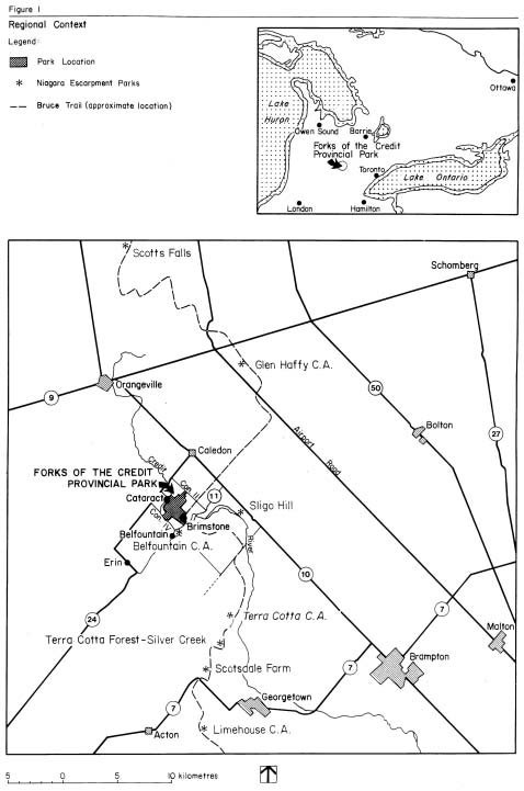
The proximity of the park to several urban centres provides a large pool of potential park visitors. The park is approximately 18 km. southeast of Orangeville, 24 km. northwest of Brampton and 40 km. northwest of Mississauga (See Figure 1).
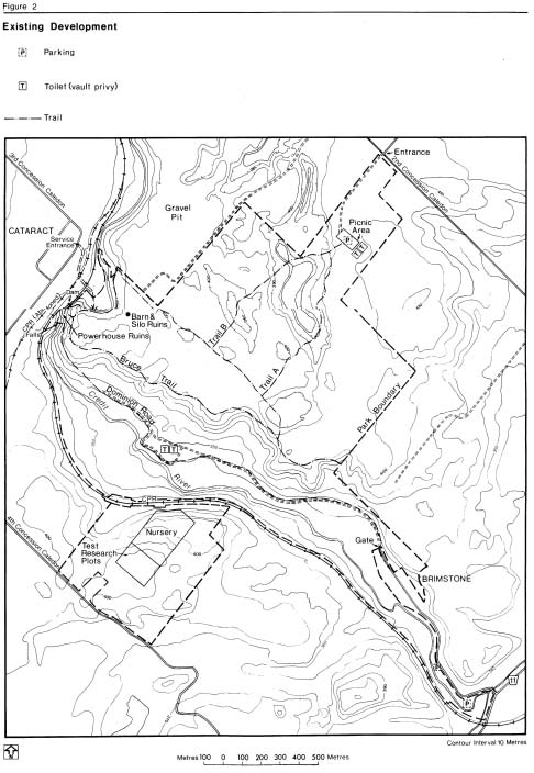
To date, little development has occurred at the park. Parking lots have been developed in several locations, and several trails have been established (See Figure 2).
The park is one of 105 existing and proposed parks in the Niagara Escarpment Parks System. This system is based on public lands acquired by a variety of agencies to protect distinctive features and areas along the Escarpment.
Terra Cotta Conservation Area which is located 12 km. south of the park has been designated as a nodal park with a distinctive role to play within the Niagara Escarpment Parks system. Terra Cotta is intended to serve as a key staging area and interpretive centre for this segment of the escarpment and the major starting place from which to explore other nearby parks including Forks of the Credit Provincial Park. The Bruce Trail, which goes through the Forks of the Credit, is an essential component of the Niagara Escarpment Parks System, linking the park to other public open spaces and scenic attractions along the Escarpment’s 725 kilometres.
This management plan will guide the development and management of the park’s natural, historical and recreational resources.
2.0 Classification
The classification of Forks of the Credit Provincial Park is "Natural Environment" in recognition of the park’s outstanding natural landscape with notable historical features and recreational opportunities. This classification conforms with recommendations for classification from the Niagara Escarpment Plan.
The development and management of Forks of the Credit Provincial Park will adhere to the natural environment class guidelines as set out in the "Ontario Provincial Parks Planning and Management Policies".
3.0 Goal
The goal of Forks of the Credit Provincial Park is to protect the park’s outstanding natural, cultural and recreational environments and to provide a variety of outdoor recreation opportunities.
4.0 Objectives
There are four established objectives of the provincial parks system: protection, recreation, heritage appreciation and tourism. The natural environment class of parks contributes to the achievement of each of these objectives.
4.1 Protection
The protection objective of the Provincial Parks System is to protect provincially significant elements of the natural and cultural landscape of Ontario.
The protection objective of this park is:
- to protect the provincially significant Caledon Meltwater Channel Complex with representative outwash kettle lake and kame hill features. In doing so, Forks of the Credit will contribute to the Ministry’s earth science protection target
- to maintain the provincially significant trout populations of the Credit River
- to protect the park’s six species of vascular plants which are regionally rare
- to protect portions of the powerhouse/mill, Dominion Road and the ruins of a dam
4.2 Recreation
The recreation objective of the Provincial Parks System is to provide outdoor recreation opportunities ranging from high-intensity day-use to low-intensity wilderness experiences.
The recreation objective of this park is to provide year-round high quality day-use recreation opportunities. The main emphasis will be on extensive activities, such as angling on the Credit River, hiking, picnicking, cross-country skiing, snowshoeing, viewing, and nature and cultural appreciation.
Approximately 10 km. of hiking trails, of various levels of difficulty, will be provided. The Bruce Trail is a major component in this trail system.
Approximately 43,000 picnicking opportunities based on 180 picnic tables will be provided. This represents 5% of the projected 811,900 picnicking opportunities for Maple District in the year 2000. The 180 picnic tables recommended by this plan differs from the estimate of 600 tables suggested in the Maple District Land Use Guidelines. This change is the result of more detailed examination of the realistic and desired carrying capacity and level of use for the park. The District Land Use Guidelines will be amended to reflect this change.
4.3 Heritage appreciation
The heritage appreciation objective of the Provincial Parks system is to provide opportunities for exploration and appreciation of the outdoor natural and cultural heritage of Ontario.
The heritage appreciation objective of this park is to provide facilities and visitor service programs that will enable park visitors to explore, interpret and appreciate the Niagara Escarpment landscape and the significant life science, earth science and cultural values of the park.
4.4 Tourism
The tourism objective of the Provincial Parks system is to provide Ontario residents and out-of- province visitors with opportunities to discover and experience the distinctive regions of the Province.
The tourism objective of this park is to provide visitors with day-use opportunities in order that they can discover and experience the Caledon Hills section of the Niagara Escarpment. The benefit of attracting day-use visitors to this site will be the contribution to the local economy through park expenditures and tourist spending.
Figure 1: Regional Context

Enlarge Figure 1: Regional Context
Figure 2: Existing Development

Enlarge Figure 2: Existing Development
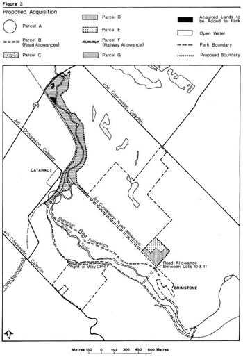
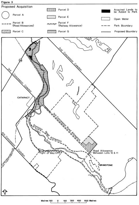
5.0 Boundary
The following are additional parcels of land proposed for purchase that will alter the present park boundary. They appear on Figure 3 and are listed below in order of priority.
Parcel A - Because of the complexity and number of property transactions in this area, acquisition will be subject to clarification of ownership and property lines. The intent of the Ministry is to own as soon as possible all the land base that contains the area’s feature attractions (e.g., powerhouse ruins, Cataract Falls, the gorge and the dam). Included in this parcel is the C.P.R. land between the two railroad tracks, and the portion of the abandoned CNR line immediately to the north of the park.
Parcel B - Opened and unopened road allowances for Dominion Road (within park boundaries), the third Concession and the road allowance between Lots 10 and 11 should be acquired. Acquisition of these allowances will consolidate the park’s land holdings, since the park is currently split into separate parcels by the road allowances. The Dominion Road allowance from the park to Cataract is included as well.
Parcel C - Acquisition of both of these small and isolated parcels, south of the railroad track, will consolidate the park’s land holding in the area. These lands are essential to the provision of pedestrian access from Cataract.
Parcel D - Purchase of this parcel will secure for the park a relatively large portion of the sensitive wooded valley slopes and a route for the Bruce Trail.
Parcel E - Acquisition will consolidate the park’s land holdings. This parcel would also provide an improved location for a key segment of the park’s trail system.
Parcel F - Canadian Pacific Railroad right-of-way within or adjacent to the park. If the railroad is abandoned in the future, acquisition of the right-of-way would be beneficial to the park. This linear stretch of land running the entire length of the park would provide level hiking opportunities, especially suitable for those individuals not physically capable of hiking the park’s other trails.
The above-listed properties represent approximately 34.5 ha (85.3 acres).
Parcel G - This parcel includes several properties along the Credit River valley lands from the park’s northeast corner up to Highway 24. Acquisition will be generally limited to the area between the top of the valley ridge on the east side and the railway tracks on the west side. Acquisition will allow the Ministry management control over the river, its significant fishery, and the flood plain. It will also be possible to provide hiking opportunities. This parcel contains approximately 30.7 ha (107.8 acres).
Because relatively little land in this proposed park extension is currently owned by the Ministry of Natural Resources, no specific proposals for development have been included in the plan.
When land acquisition in this area has been substantially completed, the park plan will be amended to cover this area.
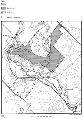
6.0 Zoning
All lands within the park’s existing 282 ha have been zoned (See Figure 4) based on existing and potential environmental qualities, required protection, and the potential for recreational and interpretive use within the context of the four park objectives.
6.1 Development zone
This zone encompasses approximately one- quarter of the park’s land base. The 70 ha area is an old field, located on the eastern upland plateau. This zone will contain the main entrance and day-use area of the park providing parking, picnicking facilities, open space areas for general play, access to trails, interpretive facilities and management/operational facilities.
6.1.1 Development zone policies
To provide day-use recreational facilities in keeping with the natural environment classification of the park.
To enhance the landscape aesthetics and the recreational potential by selective re-establishment of forest cover and landscape plantings in certain areas.
To provide convenient access to the main attractions of the park (e.g., falls, power-house/dam ruins, river gorge, bedrock exposures) and the extensive trail system.
6.2 Natural environment zone
This zone encompasses the majority of the park’s land base. The 205 ha contain the forested valley lands and valley slopes along the Credit River (125 ha), the western upland plateau (35 ha) and the eastern upland plateau (45 ha).
The valley lands and slopes contain a rich assortment of vegetation communities of various ages including lowland forest, wetlands, cleared former pasture land, deciduous forest and upland cedar forest. Two other notable natural features located in this zone are the river gorge bedrock exposure just below the falls and the significant trout population of the Credit River and its tributaries.
The western plateau contains three plant communities: plantation, former pasture lands, and experimental white pine research plots.
The eastern plateau is former pasture land containing the ponds and rolling terrain (kettle lakes in a moraine landscape) that are provincially significant as representative features of the Caledon Meltwater Channel Complex, an earth science Area of Natural and Scientific Interest (ANSI).
6.2.1 Natural environment zone policies
To accommodate extensive forms of recreational use (e.g., nature appreciation) while minimizing environmental impact.
To monitor recreational use to determine whether management actions are necessary to minimize the environmental impact.
To maintain the aesthetics of the zone through vegetation management and to enhance the aesthetics through selective landscape plantings.
To ensure no landscape alterations occur that would have a detrimental impact on the earth science features.
6.3 Historical zone
This zone is the smallest encompassing 6 ha It includes such feature attractions as the ruins of a powerhouse/mill and dam, a bridge, a portion of the old Dominion Road, a portion of the Credit River and valley lands including the falls. The area near the powerhouse ruins provides a vantage point from which to view the impressive river gorge below the falls.
6.3.1 Historical zone policies
To maintain the historical integrity of the zone.
To ensure the safety of those park visitors who visit the ruins.
7.0 Resource management policies
7.1 Landform and water management
Slope instability is a significant concern with respect to the valley slopes at, and immediately downstream from, the power house and water fall. A stability study has been carried out on the powerhouse (see Section 7.5). Engineering consultants have also examined an area of the valley which appears to be susceptible to slope failure. This area, which is located on the old Dominion Road a short distance downstream from the powerhouse, is important because it provides good viewing of the valley and the waterfall, and an important link in the park’s trail system. Further research will be carried out to determine if it is feasible to stabilize this area.
Figure 3: Proposed Acquisition
Enlarge Figure 3: Proposed Acquisition
The numerous springs in the northwest corner of the park, emanating from the escarpment, will be protected from adverse forms of recreational use and development.
Land use permits will not be issued for the former agricultural land on the west side of the park. This land will be allowed to naturally regenerate (with weed control as necessary).
7.2 Vegetation management
All of the recommendations below will be addressed in detail in a Vegetation Management Plan prior to their implementation. The eastern upland (development zone) requires visual buffering plantings, selective small scale reforestation and landscape accent and aesthetic plantings. Native species will be used.
The vegetation of the field in the Natural Environment zone in the eastern plateau will be managed (i.e., periodic mowing and/or burning) to maintain the open character of this rolling landscape. Care must be taken to protect a representative portion of the old field succession, for interpretative purposes, as well as to maintain the regionally rare plant, Aster pilosus (Aster).
Landscaping in and adjacent to the historic zone will be done to enhance the aesthetics of this zone without adversely affecting the views from the private homes situated along the edge of the valley. Permission from C.P.R. will have to be obtained if plants are to be established on their right-of-way.
Efforts will be made to re-establish vegetation on the severely-compacted slopes in the vicinity of the ruins. Controlling pedestrian use through site-planning measures (i.e., boardwalk, stairs, railings) will be essential to the success of this recommendation.
Shade tolerant shrubs will be planted on the forested slopes in areas presently eroded or susceptible to erosion.
Management of the existing forests will be limited to selective cutting of hazardous trees adjacent to trails or development areas.
The open fields in the lower valley will be managed (periodic mowing and/or burning) to maintain the open space character.
The existing tree nursery on the western upland will be left to grow naturally.
7.3 Fisheries management
Credit River management activities intended to maintain and improve the river to a condition that will support a naturally sustaining and significant trout population will be encouraged. The Ministry of Natural Resources and the Credit Valley Conservation Authority in cooperation with interest groups such as Trout Unlimited and Save Our Streams may initiate projects to this end. Possible projects are river assessment studies, creel census, river bank stabilization, boulder replacement, current deflectors, riffle creation, and spawning channel creation.
The ministry is committed to the preservation, protection and enhancement of brook and brown trout populations in the park. The Maple District Fisheries Management Plan proposes the establishment of special angling regulations. Sport fishing in the Credit River will be encouraged within the limits of sustainable use.
7.4 Wildlife management
Sport hunting and commercial trapping will not be permitted.
Control of nuisance animals will be carried out under the supervision of the Ministry. In particular, it may be necessary to control beaver populations if they are having an adverse impact on trout spawning areas or other fisheries habitat.
Development of a diversified wildlife habitat is highly desirable. In order to increase the songbird population, native shrubs may be planted along forest edges, roads, hiking trails, and along the banks of the Credit River. This will be addressed as well in the proposed Vegetation Management Plan. Bluebird boxes may be erected in the old field.
7.5 Cultural resources management
The historic powerhouse ruins and dam, the railway bridge at Cataract, and a portion of the historic Dominion Road have been placed in a historical zone. The heritage aspects of the full length of the Dominion Road will be acknowledged in the park’s visitor services program.
A study by a consulting engineering firm examined the stability and safety of the powerhouse. The study determined that the older portion of the generating station is founded on sound sandstone bedrock, and is in a safe condition from a foundation point of view for many more years.
The consultants also concluded that the newer portion of the powerhouse is in an unsafe condition because of the extensive undermining of the foundation, and could collapse in a relatively short period of time.
Underpinning the addition would be a difficult and dangerous task. Based on these findings it is the intention of the Ministry to remove the newer portion of the power house. Measures may be taken to stabilize the older portion of the ruins from further deterioration and to make them safe for viewing and interpretative purposes. However, no major reconstruction is proposed.
An archaeological survey will be carried out before any major development is initiated.
The barn and silo ruins in the development zone will remain for interpretation of past land uses. The feasibility of converting the silo to a lookout tower will be investigated.
8.0 Operations policies
A Park Operations Plan will be prepared to provide park staff with the necessary information required to operate the park on a day-to-day basis. In addition to addressing the operations policies which follow, the strategy will include such topics as budget, staffing, maintenance schedules, enforcement and emergency service. The provisions of the strategy will be consistent with the approved Ontario Provincial Operating Standards, and will be reviewed annually and updated as required.
8.1 Visitor services
A high-quality public information service in keeping with the planning and management policies for a natural environment park, will be provided. Of the three visitor service components (information, interpretation, and outdoor recreation) the former two will be emphasized.
8.1.1 Information
Objectives of this component include the following:
- inform park visitors about the park, its services, facilities and management concerns;
- promote recreation and interpretative opportunities in the local area, particularly in the context of the Niagara Escarpment Parks System
- instil a sense of respect for the park environment
- describe the role of the Ministry of Natural Resources
- provide a means for visitors to communicate their thoughts and concerns to the Ministry of Natural Resources
The objectives outlined above will be achieved through all or some of the following: publications, signs, media and personal contact.
Figure 4: Zoning
8.1.2 Interpretation
Forks of the Credit Provincial Park contains a variety of significant and interesting features (earth and life science) as well as many historical themes worthy of interpretation.
Historical
The park has nine basic historical themes: the mill/power station and dam, sandstone quarries, Credit Valley Railroad, salt springs, Dominion Road, the Gold Rush, Cataract, area legends and past recreation in the park.
Earth science
Features include the provincially significant kettle lakes and kame hills (Natural Environment Zone), and the Credit River gorge with its significant display of bedrock exposure.
Life science
Features include a diverse range of vegetative communities (with six containing regionally significant plants), the significant trout populations of the Credit River and the animal populations.
Interpretation of the above will be essentially by self-use trails in conjunction with publications and on-site facilities (i.e., plaques, signs, display boards). Proposals for an interpretation program are outlined in the report "Forks of the Credit Provincial Park: A Strategy for Interpretation and a Recreation Trail System".
Over the long term consideration will be given to constructing a small visitor centre. The centre could house displays and facilitate the use of the park for educational programs. However, it is unlikely that a visitor centre will be constructed in the time period covered by this plan.
8.2 Recreation management
Year-round day-use activities will be based on interaction with the natural environment and appreciation of the natural and cultural values of the park. Recreational activities will be low intensity in the natural environment zones. Moderate intensity activities will occur in the development and historical zone.
Extensive forms of recreational activities (e.g., hiking, fishing, cross-country skiing, nature appreciation, viewing) will be encouraged.
Motorized off-road vehicles such as snowmobiles and trail bikes will not be allowed on the trails. Because of the sensitive nature of much of the landscape, and the heavy pedestrian use which is anticipated, bicycles will only be permitted on park roads.
Picnicking, parking and access facilities will be designed so they can expand up to the recommended maximum capacity if needed.
The Ministry will cooperate with the local Bruce Trail Club (Caledon Hills) in providing an appropriate route for the Bruce Trail and any associated side trails. Careful consideration will be given in all trail planning and development to minimizing the environmental impact.
The primary access for park visitors will be from the east through the main park entrance. Access will not be developed from the north and south so as to minimize the impact of park visitors on the communities of Cataract and Brimstone. Pedestrian access will continue to be permitted from the north and south, primarily to serve local residents and Bruce Trail hikers.
No swimming facilities will be provided. The nearby Belfountain Conservation Area provides swimming opportunities.
No developed camping facilities will be provided. Over the long term consideration will be given to providing a walk-in camping area for Bruce Trail campers. This facility would only be provided if there is adequate staffing to monitor its use.
8.3 Marketing
No marketing will be carried out until adequate visitor facilities are provided. Current use periodically exceeds the capacity of the existing interim parking facilities.
A marketing plan will be prepared when development of basic park facilities is initiated. The major focus of the marketing would be to attract visitors during the week, since there is already heavy weekend use. The marketing plan will take advantage of opportunities for cooperative publicity (e.g., Niagara Escarpment Parks system, Chamber of Commerce) and will consider the possibilities for partnerships with agencies and groups such as local school boards.
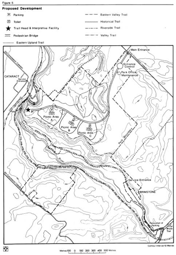
9.0 Development policies
The proposed development (see Figure 5) has been planned according to natural environment provincial park standards. All development will be carried out in accordance with approved site and development plans. Specific site designs will be responsive to environmental sensitivity, accessibility and landscape aesthetics.
9.1 Access
The only public vehicle entrance will be off Concession 2. The entrance road will traverse the development zone providing access along the way to the picnic areas and eventually ending at the proposed trail head. As development proceeds, the existing parking lot on the eastern upland will be removed.
A recently constructed pedestrian bridge over the Credit River permits access from Cataract. This bridge is intended to serve Cataract residents and will provide access to a short trail proposed for the north side of the river.
The entrance from the community of Brimstone will be maintained for park maintenance, emergency and local pedestrian use. The Bruce Trail uses this entrance.
The two existing parking lots at the south end will be retained with minor maintenance. The Ministry will consider a cooperative venture with the Town and the Credit Valley Conservation Authority for the provision of a Town-controlled parking lot in the immediate area of the Forks. The need to continue providing the two existing lots will be re-evaluated once a new parking facility is built.
A service/emergency entrance will be provided on the 4th line west.
9.2 Picnic areas
Three picnic areas are proposed with the largest area (Picnic Area "A") accommodating a maximum of 90 tables (on 12 ha) while the other two areas (Picnic Areas B and C) can handle a maximum of 45 tables each (on 6 ha each). Each picnic area will have a parking lot(s), open space for play, and washroom facilities (exact size to be determined during site planning process). The number of parking spaces will correspond with the number of tables provided. Other facilities (e.g., picnic shelters) may be provided if demand warrants.
The informal picnic area in the lower meadow will be retained. Vault toilets and picnic tables will be provided in this area. Tree planting will be required to screen the picnic areas.
9.3 Trails
Approximately 10 km. of walking trails will provide opportunities to explore and experience the park. Most of the trails have self-use interpretive potential as well as general aesthetic appeal. Interpretation, where appropriate, will be through brochures, signs, display boards and plaques. Detailed proposals have been outlined in the Interpretation Strategy and Trails Plan.
Segments of the Bruce Trail main trail and side trails currently run through the park. Because the appropriate long term route for the Bruce Trail is currently under review, it is probable that there will be some changes in the alignment of the trail within the park. The specific location will be determined through discussion between the Bruce Trail Association and parks staff. It is anticipated that the Bruce Trail will generally follow sections of the park’s trail system.
Figure 5: Proposed Development
Enlarge Figure 5: Proposed Development
The major elements of the proposed trail system are:
- Eastern Upland Trail (2.9 km) is located primarily to explore the provincially significant kame hills and kettle lakes
- Eastern Valley Trail (2.3 km) runs along the top of the valley slope and descends at the south end into the valley. The north end of the trail links with the Historical Trail
- Historical Trail (1 km) runs down the valley slope from the eastern upland and includes the power house/dam ruins, and a portion of the former Dominion Road. The trail traverses a section of the valley slope to allow viewing of the falls and the bedrock exposures. Although much of this trail exists at present, it requires substantial upgrading, in particular the installation of stairs. An extension of this trail provides access to the other side of the Credit River and the area formerly flooded by the head pond
- Valley Trail (2.5 km) runs for the most part along the original Dominion Road road bed. Some sections of this trail require major upgrading because of erosion problems.
- Riverside Trail (1.1 km) runs along the eastern shore of the Credit River and provides a loop off the Valley Trail. This trail will be kept back from the water’s edge as much as possible to minimize erosion, to avoid disturbing sensitive trout spawning areas and significant trout habitat, and to avoid disrupting the fisherman’s experience
- Other Trails. Should demand warrant, consideration will be given to the development of additional trails. However, trails will only be considered in locations where there would no significant negative environmental impact
9.4 Interpretive facilities
The primary interpretation facility will be a series of interpretive panels mounted outdoors at the main entrance to the trails system and along the trails.
Over the long term consideration will be given to constructing a small interpretive centre.
9.5 Operational/maintenance facilities
A combined park office and maintenance garage will be constructed near the entrance to the park. A separate entrance control booth will be provided as well.
10.0 Implementation priorities
All development items may be implemented as funds and priorities permit. Since the park is already attracting a considerable amount of use with resulting environmental impacts, the following items should be implemented in the early stage of development: stabilization and safety of ruins, stairs, elevated walks and railings on the slopes adjacent to the ruins, and upgrading of existing trails and provision of new ones. (This would include the installation of interpretive display boards, signs and plaques).
The next phase of park development would include the main access road, office/maintenance building, entrance control booth, parking lot near the falls and the western most picnic area. As usage increases and funds permit, the interpretive facility may be built and additional picnic areas phased in.
A Vegetation Management Plan will be prepared as soon as possible. In this way, recommended landscape plantings can become established before the park is actually developed.
In the implementation of the park plan the Ministry will actively pursue the opportunities for the involvement of other agencies and groups.
11.0 Summary of public consultation
In the Spring of 1984, notification was sent to interest groups, individuals and government agencies which were known to have an interest in the site. Their input in the planning process was requested. By the fall of 1985, the preliminary management plan and background information document were available for public review. During public review, copies of the management plan and a news release were sent to adjacent landowners and other interested parties. Notification to the general public of the review period and availability of plans for review was carried out by advertisements and news releases in local newspapers. An open house was held in the fall of 1985 at Belfountain, to present the park proposal and to receive feedback from the public. After the review period was over, the steering committee for the preparation of the plan reviewed all public input. Individual letters were sent to those agencies and private individuals who wrote requesting responses to specific questions/inputs.
The major issues which were raised during the public consultation process were:
- location of existing and proposed parking lots
- location of access routes
- location and types of trails
- protection of the Credit River and fisheries
- protection of historic features.
In general, the public comments emphasized the need to maintain the natural character of the park area. As a result of the public input and additional staff review of the proposals the following changes were made to the draft management plan:
- proposals to manage a plantation and forest research plots on the western uplands have been deleted
- the option of redeveloping power generation at Cataract has been deleted
- based on additional geotechnical work the Ministry is proposing to remove the newer portion of the powerhouse
- trail proposals have been deleted in environmentally sensitive areas
- the primary proposed interpretive facility is a series of interpretive panels, although a small interpretive centre could be constructed over the long term
- there is increased emphasis on stabilizing valley slopes near the powerhouse.
This plan reflects the input provided to the ministry during public participation.
12.0 Plan review and amendment
This management plan will be reviewed at least once every ten years to confirm or revise the resource management, operations and development policies. Minor amendments may be made in the interim as required. Major amendments having broad implications for park management will receive public review.
14.0 References
Belan, J. 1989. An Interpretation Strategy and Trail Plan for Forks of the Credit Provincial Park. Ontario Ministry of Natural Resources.
Credit Valley Conservation Authority. 1984. Belfountain Conservation Area Master Plan.
Credit Valley Conservation Authority. Interim Watershed Plan.
Ecologistics Ltd. 1979. Credit River Watershed Environmentally Significant Areas. Prepared for the Credit River Conservation Authority.
Gould, J. 1984. A Reconnaissance Biological Inventory of Credit Forks Provincial Park. Ontario Ministry of Natural Resources.
Greenland, G. 1972. Credit Forks Historical Research. Ontario Ministry of Natural Resources.
Greenland, G. 1973. Resource Inventory Report: Brief History of the Credit Forks Area, Peel County, Ontario. Ontario Ministry of Natural Resources.
Johnson, Sustronk and Weinstein and Associates Ltd. 1973. Forks of the Credit Provincial Park Master Plan. Ontario Ministry of Natural Resources (unapproved).
Kovacevic D. 1973. Proposed Provincial Park at Credit Forks: Historical Architecture Study. Ontario Ministry of Natural Resources.
Niagara Escarpment Commission. 1979. The Niagara Escarpment Plan, Volume 1,2,3.
Ontario Ministry of Culture and Recreation. 1976. Historical Resources in the Niagara Escarpment Planning Area. Historical Planning and Research Branch.
Ontario Ministry of Natural Resources. 1980. An Evaluation of Earth Science Features in the Parks, Parks Reserves and Special Areas of Central and Southwestern Regions.
Ontario Ministry of Natural Resources. 1985. Forks of the Credit Management Plan Background Information Document.
Ontario Ministry of Natural Resources. Credit Forks (Historical Account).
Ontario Ministry of Natural Resources. 1976.
Earth Science Candidate Nature Reserves in the Niagara Escarpment Planning Area. Park Planning Branch.
Ontario Ministry of Natural Resources. 1983. Maple District Land Use Guidelines.
Ontario Ministry of Natural Resources. 1983. Parks and Recreational Areas Branch, Planning Section.
Ontario Ministry of Transportation and Communications. 1974. Appraisal for Access Road to the Forks of the Credit Provincial park.
Pritten, B. Geology of Credit Forks.
Telford and Narin. 1976. Industrial Mineral Resources Inventory of the Niagara Escarpment Planning Area.
Terpstra, P. 1982. Integrated Management at Forks of the Credit Proposed Candidate Park. Ontario Ministry of Natural Resources.
Trow Ltd. 1986. Condition Assessment Cataract Power Plant Caledon, Ontario.