Freeman Township Sugar Maple Forest Conservation Reserve Management Statement
This document provides policy direction for the protection, development and management of the Freeman Township Sugar Maple Forest Conservation Reserve and its resources.
Statement of Conservation Interest (C91)
Ministry of Natural Resources
Parry Sound District
Prepared with the assistance of:
Meteek & Company
Huntsville, Ontario
March 2004
Approval statement
We are pleased to approve this Statement of Conservation Interest for Freeman Township Sugar Maple Forest Conservation Reserve (C91).
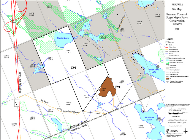
Freeman Township Sugar Maple Forest Conservation Reserve is a 123 hectare area of Crown land located in southern Freeman Ward of the Area Municipality of the Township of Georgian Bay in the District Municipality of Muskoka. The site is about 8 kilometres south of the hamlet of Mactier. It is a short distance west of Silver Sand Lake, northwest of McMaster Lake, and includes most of the shoreline of Fischer Lake. There are privately owned lands to the west, north and east sides of this site. They are not a part of the conservation reserve. Immediately to the south and east of the conservation reserve, portions of Lots 6, 7 and 8, Concession 1 are designated as Forest Reserve, and are currently under the authority of a Crown land Aggregate Permit.
Freeman Township Sugar Maple Forest Conservation Reserve, located in Hills' ecological Site District 5E-7, protects ten representative combinations of vegetation and landforms, including older maple stands on low hills with sandy soils and bare bedrock patches.
Freeman Township Sugar Maple Forest Conservation Reserve is one of 378 new protected areas approved through Ontario’s Living Legacy Land Use Strategy, aimed, in part, at completing Ontario’s system of parks and protec ted areas.
During the "Lands for Life" planning process, the public was widely consulted and provided valuable input into what became Ontario’s Living Legacy Land Use Strategy. Comments received during that time, and during consultation related to the formal Public Lands Act regulation of the boundaries of this conservation reserve, were generally supportive of the protection of this area. Stakeholders who provided comment during the earlier consultation for this site were subsequently consulted regarding the draft Statement of Conservation Interest and their comments were considered in the finalization of this document.
This Statement of Conservation Interest provides guidance for the management of the conservation reserve and provides the basis for the ongoing monitoring of activities. More detailed direction is not anticipated at this time. Should more complex resource management or conservation issues arise or significant facility development be considered, then a detailed Resource Management Plan wi ll be prepared with full public consultation.
Freeman Township Sugar Maple Forest Conservation Reserve is managed under the direction of the District Manager and the Parry Sound Area Supervisor of the Ministry of Natural Resources, Parry Sound District.
Approved by:
R. Griffiths
District Manager
Parry Sound District
Approved by:
Ron Running
Regional Director
Southern Region
1.0 Introduction
Ontario’s Living Legacy, the result of an extensive planning process that began in early 1997, culminated in the approval in July 1999 of a Land Use Strategy that identifies the intended strategic direction for Crown land, including the completion of Ontario’s system of parks and protected areas. This proces s, which included extensive public consultation, resulted in the recommendation for regulation of 378 new protected areas, including Freeman Township Sugar Maple Forest Conservation Reserve (C91).
Freeman Township Sugar Maple Forest Conservation Reserve is located in Freeman Ward in the Area Municipality of the Township of Georgian Bay, in the District Municipality of Muskoka. The site is about 8 kilometres south of the hamlet of MacTier. It borders Crown land to the south. The west, north and east sides border private lands. Highway 69/400 is less than a half kilometre to the west of this site.
The conservation reserve, in Hills' ecological Site District 5E-7, was identified during the Ontario’s Living Legacy selection process for its representation of older age maple stands on low hills with sandy soils and bare bedrock patches. Privately owned lands border the site to the west, north and east sides of this site. They are not a part of the conservation reserve. Immediately south and east of the conservat ion reserve, portions of Lots 6, 7 and 8, Concession 1, are designated as a Forest Reserve . This area is currently under the authority of a Crown land Aggregate Permit. Should the aggregate permit be surrendered in the future through normal processes, the Forest Reserve lands will be added to the regulated conservation reserve.
Conservation reserves are established under the authority of the Public Lands Act, Ontario Regulation 805/94. Freeman Township Sugar Maple Forest Conservation Reserve was established by Ontario Regulation 86/01 on April 6, 2001.
A Statement of Conservation Interest (SCI) is prepared under the direction of Procedural Guideline A – Resource Management Planning (PL. Procedure 3.03.05). The purpose of this SCI is to identify and describe the values of the Freeman Township Sugar Maple Forest Conservation Reserve. The SCI also outlines the activities that currently occur within the conservation reserve and adjacent Forest Reserve and provides guidelines for the management of current and recreational and cultural values.
1.1 Background information:
| Name | Freeman Township Sugar Maple Forest Conservation Reserve (C91) |
|---|---|
| Site Region/District | Georgian Bay 5E-7 |
| OMNR Administrative Region/District/Area | Southern Region/Parry Sound District/ Parry Sound Area |
| Total Area (ha.) | 123 hectares (plus 64 hectares adjacent Forest Reserve) |
| Regulation Date | April 6, 2001 (O. Reg. 86/01) |
| First Nations | Robinson-Huron Treaty and Williams Treaty |
| OBM map sheets | 10 17 5950 49900 |
| Topographic Map | Lake Joseph 31 E/4 |
| UTM co-ordinates | 17T 59680 499270 (Centroid) |
1.2 Representation
Earth science representation:
Bedrock – One of two gneiss associations of the Moon River Domain, Parry Sound Te rrane is represented. The Moon River gneiss association rocks observed (Blackburn, 2003) consist of pink leucogneiss, grey biotite-hornblende gneiss and mafic boudins.
Surficial – Thin till over bedrock predominates, with glaciofluvial outwash deposits at the southeast corner, extending into the adjacent Forest Reserve.
Life science representation:
Freeman Township Sugar Maple Forest Conservation Reserve (C91) was identified during the Ontario’s Living Legacy selection process for its representation of older age maple stands on low hills with sandy soils and bare bedrock patches.
Cultural resources representation:
Neither detailed cultural research nor inventory has been carried out for this conservation reserve. Recent regional evaluation (OMNR 2003) shows that there are areas near this conservation reserve that have potential for cultural heritage sites.
Recreational opportunities:
A recreational inventory report was prepared for this site based on existing knowledge and data sources of MNR staff, recent site visits, and also reflecting the field observations made during the preparation of the life science report. Currently, hunting is the main recreational use made of this site. There may be limited angling potential in Fischer Lake.
1.3 Survey work
| Survey Level | Earth Science | Life Science | Cultural | Recreational | Other |
|---|---|---|---|---|---|
| Reconnaissance | Blackburn, 2003 | Jones, 2003 | OMNR, 2003 | Larson, 2003 | None |
| Detailed | None | None | None | None | None |
| Requirement | None | Monitor the status/presence of significant species and associations. | Research to be encouraged | Monitor use impacts | None |
2.0 Values to be protected
The conservation reserve is located entirely within Hills' (1959) ecological Site District 5E -7. Values include earth science, life science and recreational/aesthetic values, with an emphasis on the life sciences.
2.1 Earth science:
(Earth science information, unless otherwise noted, is taken from Blackburn, 2003)
Bedrock:
Freeman Township Sugar Maple Forest Conservation Reserve lies within the Moon River Domain, Parry Sound Terrane of the Central Gneiss Belt of the Proterozoic Grenville Province.
The Grenville Province is the product of thrusting and imbrication of the earth’s crust to the northwest as it collided with a continental landmass to the southeast. The Grenville Orogeny, circa 1140 to 1070 million years ago, culminated more than 500 million years of crustal evolution. The eroded rocks of the products of these events are displayed in the complexly metamorphosed and deformed rocks of the region (Easton, 1992b).
The Parry Sound Terrane is one of the four lithotectonic terranes of the Central Gneiss Belt. The Moon River Domain is one of three structural domains of the Parry Sound Terrane. The Moon River Domain has been divided into two gneiss associations (Easton 1992a) based on rock type. The Moon River gneiss association rocks underlie this site. Rocks of this association are orthogneiss, voluminous pink leucogneiss and minor supracrustal rocks (Easton 1992a), with the presenc e of grey biotite-hornblende gneiss and mafic boudins.
This geological environment is part of the modern organization of the complex products of the mid-Proterozoic orogenic events (Easton 1992a & b). As such, their representation in Freeman Township Sugar Maple Forest Conservation Reserve contributes to the conservation of the Grenville Province continental accretion theme (Davidson, 1981).
The geological features of the conservation reserve are of local significance in the representation of components of the Moon River Domain, Parry Sound Terrane.
Surficial:
Freeman Township Sugar Maple Forest Conservation Reserve lies mostly in an area of bedrock plain with a thin cover of till. The northern quarter of the site is low, with a cover of organic materials. Glaciofluvial outwash deposits lie outside of this site to the south and east. The adjacent Forest Reserve lies on these deposits.
Surficial geology of the conservation reserve is locally significant.
2.2 Life science:
The conservation reserve is located within Hills' (1959) ecological Site District 5E-7. Life science significance is determined on the basis of the following criteria: representation, diversity, condition, ecological considerations and special features (Crins and Kor 1998).
Representation:
(Life science information, unless otherwise noted, is taken from Jones, 2003)
The predominant vegetation type in Freeman Township Sugar Maple Forest Conservation Reserve and the adjacent Forest Reserve is a species-rich deciduous forest dominated by sugar maple (Acer Saccharum ), usually with a significant component of yellow birch (Betula allegheniensis) and/or American beech (Fagus grandifolia) and a noticeable presence of black cherry (Prunus serotina). The sub-canopy is sugar maple with some beech. This forest has great diversity of herb species in the ground flora, such as purple trillium (Trillium erectum ), rosy twisted-stalk (Streptopus roseus), northern beech fern (Phegopteris connectilis), and long-stalked sedge (Carex pedunculata), in addition to the more widespread species such as sarsaparilla (Aralia nudicaulis) and New York fern (Theylpteris noveboracensis).
There are low areas of water drainage (small creeks in spring and after rains) which are generally filled with fringed sedge (Carex crinita), royal fern (Osmunda regalis) and sensitive fern (Onoclea sensibilis ). Three patches of club-spur orchids (Platanthera clavellata) were seen in one such drainage. Finally, some areas of higher, drier ground occur within the sugar maple forest, where young red oaks (Quercus rubra) are present with a ground cover of bracken fern (Pteridium aquilinum ). Yellow birch becomes dominant in a few places, forming a yellow birch forest with black cherry as an associate, a sub -canopy of sugar maple, and a ground cover of cinnamon fern (Osmunda cinnamomea).
A large wetland, a tamarack (Larix laricina )-black spruce (Picea mariana) bog, lies on the west side of Fischer Lake. Along the lake, the bog is open and on a floating mat, while to the west it is more stable and has small trees. The bog is quite large and extends outside of the conservation reserve. An island of rock with dry white pine forest sits in the middle of this bog. As is typical of most bogs, the species list is short and consists mostly of Virginia chain fern (Woodwardia virginica), cotton-grass (Eriophorum virginicum ), leatherleaf (Chamaedaphne calyculata), and bog rosemary (Andromeda glaucophylloides). White beak -rush (Rhynchospora alba) occurs at the edge of the floating mat along the lake. The bog has a moat of water around the outside where there is a little more diversity including bulrush (Sparganium emursum ), water arum (Calla palustris), waterlily (Nymphaea odorata), and leopard frogs.
The conservation reserve also contains a white pine swamp. This community has 85% cover of white pines 15-18 m tall, with a sub -canopy of red maple and a tall shrub layer of young hemlocks, in an area of wet and spongy ground with Sphagnum mosses and pools of water. This vegetation type may be the provincially rare White Pine Coniferous Mineral Swamp that occurs in Site Regions 6E and 7E, ranked by NHIC as S2 (Bakowsky, 1996).
Finally, there are open rock barrens, some of them very large, on top of bedrock knolls. These areas have scattered white pine and red oak with grassy areas of wavy hair grass (Deschampsia flexuosa), patches of reindeer lichens (Cladina rangiferina and C. mitis), and patches of open bare rock with crustose lichens. In the largest of these areas there were several white oaks (Quercus alba) present. The ubiquitous European sheep sorrel (Rumex acetosella) is common here. The largest of these barrens has an open area of about 8-10 hectares and is the highest point in the reserve, being 14-18 m above the average level of the maple forests and Fischer Lake. Several smaller examples of barrens also occur scattered throughout the site.
In the adjacent Forest Reserve, there are large areas of pure hemlock forest, southeast of the quarry. These forests generally have supra-can opy white pines (Pinus strobus), and a ground cover of cinnamon fern and peat mosses (Sphagnum spp.). On higher ground these hemlock forests may have a dense understory of young balsam fir (Abies balsamea). Also in this area is a small area of white pine- hemlock-red maple (Acer rubrum) forest with scattered white cedar (Thuja occidentalis) present. The pines are fairly tall, to 25 m high, and the ground species include wintergreen (Gaultheria procumbens ), goldthread (Coptis trifolia), wild raisin (Viburnum cassinoides), and partridge berry (Mitchella repens).
Condition:
The forests of the conservation reserve vary in age, ranging from middle age to mature, and there are places where larger trees are present. There is little evidence of disturbance wi th the exception of some scattered rotting stumps. A small area of intense young sugar maple regeneration in the southeast corner of the site is a result of more recent forest harvest.
Diversity:
Ten landform-vegetation types were documented during the one day site inspection. These vegetation types were defined using standard ecological land classifications of Ontario (Chambers et al. 1997, Lee et al. 1998, NHIC 2002 and Harris et al. 1996) which have been applied to create a complete classification for the greater Georgian Bay area by Jalava et al. (2002). The 10 landform-vegetation types provide habitat for at least 119 vascular plant species.
Ecological considerations:
Freeman Township Sugar Maple Forest Conservation Reserve is a small, isolated protected area surrounded on 3 sides by patent lands, within a mostly natural landscape context. The site is only 1-2 kilometres north of the Moon River but is disconnected from the protected part of this water system (Lower Moon River Conservation Reserve C90 and Moon River Conservation Reserve C94) by the Highway 69 corridor. The Forest Reserve, which is under the authority of a Crown land Aggregate Permit, has some features (e.g. a regionally significant witch hazel community) which add to the value of the adjacent conservation reserve.
Special features:
Anecdotal information indicates frequent sightings of eastern massasauga rattlesnake (Sistrurus catenatus catenatus ) in the area. The Ontario Herpetofaunal Summary reports brown snakes and northern water snakes in the vicinity of the conservation reserve near Silver Sand Lake.
A population of witch hazel (Hamamelis virginiana ) was identified in the northeast corner of Lot 6, Concession 1 (Crins, 2003). This is outside of the conservation reserve, but within the adjacent Forest Reserve. This population constitutes the only known location in the Parry Sound District, and is probably the northern-most population in Ontario. As it is one of the few such populations in Ecoregion 5E, it is regionally significant.
2.3 Cultural values:
While no specific cultural studies or inventories have been undertaken within the conservation reserve and adjacent Forest Reserve , and no major cultural resource values have been evaluated or identified to date, recent regional evaluation (OMNR 2003) shows that there are areas near this conservation reserve that have a high potential for cultural heritage sites, and there a several registered cultural heritage site reserves along the nearby Moon River.
2.4 Recreational/aesthetic values:
Hunting appears to be the primary recreational activity that has traditionally occurred within the conservation reserve’s boundaries. There are no recreation camps within the conservation reserve or Forest Reserve. Fischer Lake may have some limited potential for angling.
There is little evidence of all-terrain vehicle or snowmobile use within the conservation reserve. It is expected that there is some use of all-terrain vehicles associated with hunting activity.
There is little evidence of the use of the conservation reserve by hikers, birdwatchers, mountain bikers, skiers, or snowshoers.
The distance of this conservation reserve from urban areas has resulted in a relatively pristine night sky, which enhances the sense of remoteness and wilderness of this site. Pristine night skies are considered a significant value, given the increasingly limited areas of southern and central Ontario which are not heavily affected by light pollution.
3.0 Management guidelines
3.1 Land tenure:
Background:
Freeman Township Sugar Maple Forest Conservation Reserve comprises 123 hectares of Crown land. Private lands abut its boundaries on its north half. It is adjacent to Crown lots on its south half. The south portions of Lots 7 and 8, and much of lot 6, Concession 1, immediately to the south of this site, are a Forest Reserve, under a Crown land Aggregate Permit for the extraction of sand and gravel.
The conservation reserve is not within a Bear Management Area. It lies within one Bait Fish Block (PS0185), and one registered trapline (PS -192). There are no authorized recreation camps within the boundaries of the conservation reserve or Forest Reserve.
A portion of the conservation reserve, south of Fischer Lake was once used for maple syrup production under the authority of a land use permit. This activity ceased about 1992.
Guideline:
The sale of Crown lands within the conservation reserve is not permitted.
There are no plans by the MNR to acquire private lands to add to the conservation reserve.
Should the aggregate permit be surrendered in the future through normal processes the Forest Reserve land will be added to the regulated conservation reserve.
Fur harvest is permitted to continue in the registered trapline area. Bait Fish harvesting is permitted to continue under the authority of the Bait Fish Block.
The conservation reserve is not currently within a Bear Management Area. If current Bear Management Area boundaries change, this site, or portions of it, cannot be incorporated into a Bear Management Area.
New recreation camps are not permitted.
3.2 Development:
Background:
There are no Crown owned buildings or other facilities within the conservation reserve.
No roads or trails are located within the site. Highway 69/400 is within ½ kilometre to the west of this site, and a municipal road, Silver Sands Road runs north-south about the same distance to the east of the site. There is road access by way of Pit Road, from the Highway 69 corridor through the Forest Reserve, providing access to the aggregate pits under the authority of the Aggregate Permit. This access road is scheduled to be closed with the completion of the multi-lane (limited access) highway construction.
Guideline:
Based on prior commitments, an alternative access to the Forest Reserve will be permitted from the municipal road to the east, subject to review by MNR, but this will not pass through any portion of the conservation reserve. New roads for resource extraction and/or private use will not be permitted within the conservation reserve, nor are other new roads permitted in the Forest Reserve . There is no intention to develop roads outside of the conservation reserve to improve access to this site.
New recreational trails may be considered on a case by case basis provided that they meet Procedural Guideline B–Land Uses–Test of Compatibility (see Appendix 1) and the MNR's Environmental Assessment Act requirements. Public consultation will generally be required during the consideration of changes to existing trails, and will always be required for new trails.
New recreational trails for motorized vehicles will not be permitted, unless the following have been demonstrated:
- there is a community need for the trail, as well as community support
- there are no alternative suitable locations outside the conservation reserve
- the trail location would be acceptable and suitable for four-season use
- the trail would meet the requirements applicable to all trails, as identified in the preceding paragraph
Unauthorized works within the conservation reserve will be handled in accordance with the Public Lands Act, and any required removal of improvements will be at the expense of those responsible.
No mineral exploration is permitted within this conservation reserve. This policy decision is based on a commitment made by the Ministry of Natural Resources and the Ministry of Northern Development and Mines in March 2002. This policy direction replaces that identified in the 1999 Ontario’s Living Legacy Land Use Strategy (OMNR 1999), which stated that controlled mineral exploration would be permitted in new conservation reserves which were identified as having provincially significant mineral potential.
Any new development must meet MNR's commitments to protect cultural heritage values (see Section 3.7).
While there is no intent at present to provide or permit any new development in this conservation reserve that would require lighting, should this be considered at some point in the future the MNR will not allow unnecessary, undirected light pollution. This commitment recognizes the wilderness values provided by a pristine night sky.
3.3 Recreational activities:
Background:
Hunting is the only recreation activity that has been documented in the conservation reserve. There may be unauthorized trails used in association with hunting activity. There are no authorized snowmobile or all-terrain vehicle trails within the site.
Fischer Lake has limited potential for angling, but this is a permitted activity.
There is little evidence of the use of the conservation reserve by hikers, birdwatchers, canoeists, mountain bikers, skiers, or snowshoers.
Guideline:
Hunting and angling are permitted to continue within the conservation reserve.
Recreational use such as hiking, wildli fe viewing, snowshoeing, and cross-country skiing, while currently very limited in extent and therefore not managed, will be allowed to occur in the conservation reserve.
The use of all-terrain vehicles and snowmobiles will be monitored to ensure that the conservation reserve values are not being adversely impacted. Off-trail use of snowmobiles and all-terrain vehicles is only permitted for the direct retrieval of game.
As discussed in Section 3.2 Development, new recreational trails may be considered on a case by case basis provided that they meet Procedural Guideline B–Land Uses–Test of Compatibility (see Appendix 1) and the MNR's Environmental Assessment Act requirements. Public consultation will generally be required during the consideration of changes to existing trails, and will always be required for new trails. Any new trails must meet MNR's commitments to protect cultural heritage values (see Section 3.7).
New recreational trails for motorized vehicles will not be permitted, unless the following have been demonstrated:
- there is a community need for the trail, as well as community support
- there are no alternative suitable locations outside the conservation reserve
- the trail location would be acceptable and suitable for four-season use
- the trail would meet the requirements applicable to all trails, as identified in the preceding paragraph
New recreational activities will be considered on a case by case basis provided they are consistent with maintaining the values of the conservation reserve and comply with Procedural Guideline B – Land Uses–Test of Compatibility (Appendix 1) and with MNR's Environmental Assessment Act requirements. Emphasis will be placed on activities that have a low impact on the environment of the conservation reserve.
Monitoring of existing and permitted activities will be undertaken as required to ensure that the conservation reserve values are not being adversely impacted.
3.4 Commercial activities:
Background:
There has been no recent commercial forest harvesting or mining activity within the conservation reserve.
There is currently one registered trapline covering this conservation reserve, and bait fish harvesting is authorized through one Bait Fish Block licence which covers the conservation reserve. There is no Bear Management Area in the vicinity of this site. These activities were discussed in Section 3.1 Land Tenure – Background.
Maple syrup production was allowed in this site until 1992, authorized by land use permit.
The adjacent Forest Reserve is under the authority of an Aggregate Permit, which will continue. The permit does not cover any portion of the conservation reserve.
Guideline:
Fur harvesting and bait fish harvesting operations are allowed to continue within the conservation reserve. New trapline cabins are not permitted within conservation reserves.
Maple syrup production will no longer be authorized in this site.
Aggregate extraction is allowed to continue in the adjacent Forest Reserve, under the authority of the Aggregate Permit, but it will not be permitted within the conservation reserve.
Mineral exploration is not allowed in this conservation reserve, as discussed in Section 3.2.
Conservation reserve regulations do not permit mining, commercial forest harvesting, hydroelectric power development, the extraction of aggregate and peat or other industrial uses (Public Lands Act, Ontario Regulation 805/94). Other new commercial activities must meet the requirements of Procedural Guideline B–Land Uses–Test of Compatibility (see Appendix 1).
3.5 Aboriginal interests:
Background:
This site is known to be of interest to many First Nation communities. There are 2 treaties associated with the area: the Robinson – Huron Treaty of 1850 and the Williams Treaty. A Supreme Court decision in 1994 (Howard) validated that the Williams Treaty surrendered hunting, fishing and trapping rights of those First Nations affiliated with that treaty.
Guideline:
The regulation and management of this conservation reserve will not impede the exercise of existing aboriginal or treaty rights. These rights include hunting, fishing, fur harvesting, gathering of plants for a variety of purposes, and the use of ceremonial sites. It is recognized that the manner in which these rights are carried out is not limited to the manner in which they were carried out in the past, but has evolved over time with changes in technology.
While there are no existing First Nation land claims that extend to this site, it is recognized that at some point in the future there is a possibility of a land claim in this area. If such a land claim is determined to be valid, the Conservation Reserve designation is not irreversible and does not preclude consideration of these lands in the settlement of a claim. If deregulation of part or all of a conservation reserve occurs as part of the settlement of a claim, this will be carried out at no cost to First Nations.
3.6 Natural Resource Stewardship:
Background:
Vegetation management for specific purposes (other than for maple syrup production and some limited logging) is not known to have occurred in the past. Wildlife and fisheries management has been occurring according to the prevailing policies and legislation.
The emphasis will be on ensuring that the natural values of the conservation reserve are not negatively affected by current and future activities. Therefore, applications for new specific uses will be carefully studied and reviewed. Necessary studies may be undertaken by proponents, the Ministry, and/or partner organizations.
The natural values of the Forest Reserve will also be protected subject to the rights of the Aggregate Permit holder, which predate the Ontario’s Living Legacy programme.
Guideline – Vegetation:
The intent of this site is to allow the existing vegetation communities to evolve naturally.
In accordance with existing conservation reserve policy and the Forest Management Strategy for Ontario, forest fire protection will endeavour to use "light on the land" techniques, which do not unduly disturb the landscape, in this conservation reserve. Examples of light on the land techniques may include limiting the use of heavy equipment, and limiting the number of trees felled during fire response efforts. Input from the local MNR Area Supervisor would be solicited if a forest fire threatens the area. Opportunities for prescribed burning to achieve resource management objectives may be considered. Plans for any prescribed burning will be developed in accordance with the OMNR Prescribed Burn Planning Manual.
Programs may be developed to control forest insects and diseases in the conservation reserve where these threaten significant values in or adjacent to the site. Where insects or disease threaten significant values, in or adjacent to the site, and MNR determine s that control is warranted, control within the conservation reserve will be directed by the MNR as narrowly as possible to the specific insect or disease. Biological control will be used wherever possible. In all cases, regard shall be had for Procedural Guideline B–Land Uses–Test of Compatibility (see Appendix 1).
Guideline – Wildlife and fisheries:
The relevant Ontario hunting and fishing regulations will guide hunting and fishing within Freeman Township Sugar Maple Forest Conservation Reserve and the adjacent Forest Reserve . Fur harvesting and bait fish harvesting will be managed through the maintenance of the current licensing system.
The Ministry will monitor the site for potential impacts of activities of snowmobile and all-terrain vehicles on the natural values of the conservation reserve.
3.7 Cultural Resource Stewardship:
Background:
No specific studies or inventories have been undertaken within the conservation reserve, and no specific significant cultural resource values have been eva luated or identified to date. Recent regional evaluation (OMNR 2003) shows that there are areas near this conservation reserve that have potential for cultural heritage sites and there are several registered cultural heritage site reserves along the nearby Moon River.
Guideline:
Should the MNR consider either carrying out or permitting new structural development, significant clearing of vegetation or altering of land within this conservation reserve, the MNR will adhere to the cultural heritage resource screening process as is identified in its Memorandum of Understanding (MOU) with the Ministry of Culture. While the purpose of this MOU is to provide a process to identify and protect cultural heritage resources when the MNR is reviewing work permits or disposing of Crown rights under the authority of the Public Lands Act, the considerations and criteria would also enable the MNR to identify high potential cultural heritage areas for other purposes within conservation reserves. If the screening process indicates that the site of a proposed activity is within an area of high cultural heritage potential, the MNR will consult with the Ministry of Culture to determine the appropriate cultural heritage assessment requirements and will undertake a preliminary archaeological assessment if appropriate.
Interested partners will be encouraged to undertake inventories, studies, and research to document the histories of First Nations, settlement, resource harvest/management and recreation in the area. The MNR will discuss the appropriateness of any proposed archaeological assessment with local First Nations and the Ministry of Culture.
3.8 Client services:
Background:
Access to the conservation reserve has generally been confined to traditional uses for the current commercial and recreational activities. There are no Crown facilities or services developed on or adjacent to the conservation reserve. The information fact sheet for this conservation reserve is currently available to the public through the Parry Sound District Office, Parry Sound Area Office, or via the internet at www.ontarioslivinglegacy.com. (Link no longer active.)
Guideline:
The focus will remain on low key information and self-interpretation of conservation reserve values and features. Consideration will be given to the preparation of an information brochure (with map) to highlight the features for which the area was identified and appropriate uses to ensure the protection of those features.
Consideration will be given to the strategic location of identity signs where the western boundary of the conservation reserve lies adjacent to the highway corridor. There are no other plans for structural development within this conservation reserve.
3.9 Research:
Background:
Research to date has included a number of reconnaissance surveys to document earth science, life science and recreation values.
Guideline:
Research focussing on the assessment of use and activity impacts on sensitive species and habitats will be encouraged.
All research will be carried out in a non-destructive manner. Research proposals must follow Procedural Guideline C – Research Activities in Conservation Reserves (Appendix 3).
3.10 Marketing background:
There has been no marketing of this conservation reserve to date. Promotion and information about this site has been primarily through the Ontario’s Living Legacy planning process and recent MNR Parry Sound District public consultation regarding the boundaries of this site.
Guideline:
Marketing activities of this conservation reserve will be kept to a minimum.
4.0 Implementation
Administrative responsibility for this conservation reserve belongs to the Parry Sound Area Office of the Parry Sound District of the Ministry of Natural Resources. The Area Office will continue to have the cus todial care of Freeman Township Sugar Maple Forest Conservation Reserve. Emphasis will be placed on awareness information highlighting reserve values, and monitoring and managing the current approved uses.
Priorities will include:
- Ensure compliance to prescribed management direction of the approved SCI
- Have the location of the eastern boundary surveyed by an O.L.S. in the area of Fischer Lake
- Monitor and evaluate existing and allowed recreational and commercial use levels and impacts as required to ensure that conservation reserve values are not being adversely impacted
- Encourage further inventory and research of the significant life science resources of the conservation reserve and adjacent Forest Reserve
- Encourage research about use/activity impacts on sensitive species and habitats
- Support cooperative ongoing education of resource users with respect to resource and land stewardship values, in order to maintain the ecological integrity of the site and to provide long term recreational opportunities
- Provide client services (e.g. brochure or fact sheet) at nearby MNR offices
5.0 Review and revision of the Statement of Conservation Interest
This Statement of Conservation Interest will be amended through a standard process of minor and major amendments. Minor amendments will be processed in a relatively informal manner and will require the approval of the Area Supervisor. These amendments will deal with uses and activities that do not affect any of the policies in this SCI (e.g. new uses and/or activities that are consistent with existing permitted uses).
Uses and/or activities that were not anticipated in the approved SCI and which may have an impact on the values of the conservation reserve will require a major amendment. This will include an opportunity for public comment and input, and will require the approval of the District Manager and Regional Director.
6.0 References
Bakowsky, W. D., 1996. Vegetation Communities of Southern Ontario. OMNR Natural Heritage Information Centre, Peterborough.
Blackburn C. E. 2003. C91 Freeman Township Sugar Maple Forest Conservation Reserve. Earth Science Report, OMNR Peterborough.
Chambers, B. A., B. J. Naylor, J. Nieppola, B. Merchant and P. Uhlig. 1997. Field Guide to Forest Ecosystems of Central Ontario; SCSS Field Guide FG-01. Ontario Ministry of Natural Resources.
Crins, W. J. and Kor, P. S. G. 1998. Natural Heritage Gap Analysis Methodologies Used by the Ontario Ministry of Natural Resources. Unpublished Paper. Peterborough: OMNR.
Crins, W. J. 2003. December 5, 2003 e -mail to Dorothy Shaver.
Davidson, R. J. 1981. A framework for the conservation of Ontario’s earth science features. Ontario Ministry of Natural Resources, Toronto, 262 p.
Easton, R. M. 1992a. The Grenville Province and the Proterozoic history of central and southern Ontario; in Geology of Ontario, Ontario Geological Survey, Special Volume. 4, Part 2.
Easton, R. M. 1992b. Tectonic evolution of Ontario. Part 3: Mesoproterozoic evolution of the southeast margin of Laurentia; in Geology of Ontario, Ontario Geological Survey, Special Volume 4, Part 2.
Harris, A. G., S.C. McMurray, P. W. C. Uhlig, J. K. Jeglum, R. F. Foster and G. D. Racey. 1996. Field guide to the wetland ecosystem classification for northwestern Ontario. Ontario Ministry of Natural Resources, Northwest Science and Technology Unit, Thunder Bay. Field Guide FG-01.
Jalava. J. V., W. L. Cooper and R. Ben-Oliel. 2002. Georgian Bay Coast Project – Phase I Summary. The Nature Conservancy of Canada, Toronto.
Hills, G. A. 1959. A Ready Reference to the Description of the Land of Ontario and its Productivity. Ont. Dept. of Lands and Forests, Division of Research, Maple, Ontario.
Jones, J. 2003. Natural Heritage Area – Life Science Checksheet Freeman Township Sugar Maple Forest Conservation Reserve. OMNR, Parry Sound.
Larson, S. 2003 Recreation Resource Inventory Report. Freeman Township Sugar Maple Forest Conservation Reserve. OMNR Parry Sound.
Lee, H. T., W. D. Bakowsky, J. Riley, J. Bowles, M. Puddister, P. Uhlig and S. McMurray. 1998. Ecological Land Classification for Southern Ontario: First Approximation and Its Application. OMNR, Southcentral Science Section, Science Development and Transfer Brancyh. SCSS Field Guide FG-02.
Natural Heritage Information Centre. 2002. Natural Areas and Element Occurrence Databases. Ontario Ministry of Natural Resources, Peterborough.
Noble, T. W 1983. Biophysiographic Analysis, Site Region 5E, Algonquin Region, Ministry of Natural Resources. Algonquin Region, Huntsville.
Ontario Ministry of Natural Resources. 1999. Ontario’s Living Legacy: Land Use Strategy. Queen’s Printer for Ontario. 2003. Cultural Heritage Registered Site Reserves and Areas of High Potential, Parry Sound District, Scale 1:150000.
Appendices
Appendix 1
Procedural Guideline B – Land Uses – Test of Compatibility (PL Procedure 3.03.05)
The conservation reserve policy provides broad direction with regard to the permitted uses. The policy provides only an indication of the variety of uses that will be considered acceptable in conservation reserves. The only caution is that "any new uses, and commercial activities associated with them, will be considered on a case by case basis, and, they must pass a test of compatibility to be acceptable." What does a 'test of compatibility' mean?
An examination of this must start from the premise of why an area is set aside – specifically, its representative natural heritage values. Criteria are then identified to guide compatibility considerations. These criteria apply to the long-term acceptability of both existing uses and new uses.
-
Conformity to SCI/RMP: SCI describe values for which an area has been set aside and the range of appropriate uses that will be permitted in the area. SCI may also speak to the acceptability of other 'new' uses currently not occurring in the
The first 'test' is: "do proposed new land uses and/or commercial activities conform to the direction of the SCI/RMP for the conservation reserve? Would the new use(s) depart from the spirit of appropriate indicator land uses in the SCI/RMP?"
- Impact Assessment: If the proposed use(s) pass test 1 it is important to determine their impact on the area before they are approved. This should include the following:
- Impact on natural heritage values: "will the new use(s) impact any natural values in the area? If so how and to what degree? Is it tolerable?"
- Impact on cultural values: "will the new use(s) impact an historical or archaeological values in the area?"
- Impact on research activities: "will the new use(s) affect research activities in the area?"
- Impact on current uses: "will the new use(s) have any negative impact on the array of current uses?"
- Impact on area administration: "will the new use(s) increase administrative costs and/or complexity?" (For example, the cost of area monitoring, security and enforcement)
- Impact on accommodating the use outside the conservation reserve: "Could the use(s) be accommodated as well or better outside the conservation reserve?"
- Impact on socio-economics of the area: "will the new use(s) affect the community(ies) surrounding the area in a positive or negative way?" (For example, will the new use make an area less remote thereby affecting a local tourism industry that is dependent on the area’s remoteness for its appeal?"
- Impact on area accessibility: "does the new use(s) give someone exclusive rights to the area or a portion of the area to the exclusion of other existing uses?"
The following table (Appendix 2) provides a guide of indicator uses for the consideration of uses that may be permitted within conservation reserves. For any specific conservation reserve that test of compatibility should be applied to determine which specific uses are acceptable.
Appendix 2
Indicator Uses for Conservation Reserves: Generic and specific
Recreation
| Activities | Generic Policy Permitted? Existing | Generic Policy Permitted? New | Specific Application in Freeman Twp Sugar Maple Forest CR | Specific Application in Adjacent Forest Reserve |
|---|---|---|---|---|
| Sport fishing | Yes | Yes | Yes | Yes |
| Sport hunting | Yes | Yes | Yes | Yes |
| Food gathering | Yes | Yes | YesA | YesA |
| Facility infrastructure | Maybe | Maybe | Maybe | Maybe |
| Off-trail snowmobiling | No1 | No1 | No1 | No1 |
| Off-trail all-terrain vehicle use | No1 | No1 | No1 | No1 |
| Rock climbing/caving | Maybe | Maybe | N/A | N/A |
| Canoeing/kayaking | Yes | Yes | Yes | N/A |
| Motorized boating | Yes | Yes | Maybe | N/A |
| Picnicking | Yes | Yes | Yes | Yes |
| Camping | Maybe | Maybe | Yes | Yes |
| Trails: Hiking | Yes | Maybe | MaybeB | MaybeB |
| Trails: Cross country skiing | Yes | Maybe | MaybeB | MaybeB |
| Trails: Cycling | Yes | Maybe | MaybeB | MaybeB |
| Trails: Horse riding | Yes | Maybe | MaybeB | MaybeB |
| Trails: Snowmobiling | Yes | Maybe | MaybeB | MaybeB |
| Trails: All-Terrain Vehicles | Yes | Maybe | MaybeB | MaybeB |
Science, education & heritage appreciation
| Activities | Generic Policy Permitted? Existing | Generic Policy Permitted? New | Specific Application in Freeman Twp Sugar Maple Forest CR | Specific Application in Adjacent Forest Reserve |
|---|---|---|---|---|
| Research | Yes | Yes | Yes | Yes |
| General walking | Yes | Yes | Yes | Yes |
| Photography & Painting | Yes | Yes | Yes | Yes |
| Wildlife viewing | Yes | Yes | Yes | Yes |
| Outdoor Education/Interpretation | Yes | Yes | Yes | Yes |
| Collecting | No | Maybe2 | Maybe2 | Maybe2 |
Commercial activities
| Activities | Generic Policy Permitted? Existing | Generic Policy Permitted? New | Specific Application in Freeman Twp Sugar Maple Forest CR | Specific Application in Adjacent Forest Reserve |
|---|---|---|---|---|
| Food harvesting | Maybe | Maybe | No | No |
| Fishing | Maybe | Maybe | No | No |
| Baitfish harvesting | Yes | Maybe | Yes | Yes |
| Fur harvesting | Yes | Maybe | Yes3 | Yes3 |
| Trap cabins | Yes | No | MaybeC | MaybeC |
| Resort - outpost camp | Yes | No | No | No |
| Outfitting - bear management | Yes | No | No | No |
| Wild rice harvesting | Yes | Maybe | N/A | N/A |
Resource management
| Activities | Generic Policy Permitted? Existing | Generic Policy Permitted? New | Specific Application in Freeman Twp Sugar Maple Forest CR | Specific Application in Adjacent Forest Reserve |
|---|---|---|---|---|
| Inventory monitoring | Yes | Yes | Yes | Yes |
| Featured species management | Maybe | Maybe | Maybe | Maybe |
| Natural systems management | Maybe | Maybe | Maybe | Maybe |
| Insect and disease control | Maybe | Maybe | Maybe | Maybe |
Industrial activities
| Activities | Generic Policy Permitted? Existing | Generic Policy Permitted? New | Specific Application in Freeman Twp Sugar Maple Forest CR | Specific Application in Adjacent Forest Reserve |
|---|---|---|---|---|
| Timber harvesting | No | No | No | No |
| Mineral exploration | No | No | No | No |
| Mining | No | No | No | Yes8 |
| Hydro generation | No | No | No | No |
| Energy transmission corridors | Yes | No4 | No4 | No4 |
| Communications corridors | Yes | No4 | No4 | No4 |
| Public transportation corridors | Yes | No4 | Maybe4 | Maybe4 |
| Resource access roads | Maybe | No | No | Yes7 |
| Private access roads | Maybe | No5 | No5 | No |
Other activities
| Activities | Generic Policy Permitted? Existing | Generic Policy Permitted? New | Specific Application in Freeman Twp Sugar Maple Forest CR | Specific Application in Adjacent Forest Reserve |
|---|---|---|---|---|
| Land Disposition | Maybe6 | No6 | No6 | No6 |
| Recreation Camps | YesC | No | No | No |
Notes:
On generic policy application in conservation reserves:
1 For direct retrieval of game only.
2 Only as a part of an approved research project.
3 Transfer requests will be considered in the context of the Statement of Conservation Interest or Resource Management Plan for each conservation reserve.
4 Existing use is permitted to continue. New transportation corridors, communications lines, and
transmission lines are discouraged in conservation reserves except under unusual circumstances where there are no other viable alternatives.
5 New private roads, including additions to existing roads, will not be permitted except where there are existing commitments.
6 Sale of Crown lands in conservation reserves is not permitted, except for certain minor dispositions (e.g. sale of small parcel of land where adjacent private lot is too small to enable installation of a septic system, or to facilitate legal title to lands where there has been a long-standing encroachment of a dwelling on Crown land) where they do not detrimentally affect the values an area is intended to protect.
7 Roads associated with the Crown land Aggregate Permit are allowed within the Forest Reserve, subject to MNR approval.
8 Removal of sand and gravel is permitted under the authority of a Crown land Aggregate Permit.
On specific policy application in Freeman Township Sugar Maple Forest Conservation Reserve:
A Food gathering is permitted for personal consumption only and must be conducted in a sustainable manner, and such that it does not harm the values of the conservation reserve.
B Additional high impact recreational trails are discouraged, but new trails may be considered on a case by case basis, provided they comply with Procedural Guideline B – Land Uses – Test of Compatibility (Appendix 1), and the MNR’s Environmental Assessment Act requirements.
C Existing authorized uses can continue. New cabins, outpost camps and private recreation camps are not permitted.
Appendix 3
Procedural Guideline C
Research Activities in Conservation Reserves (PL Procedure 3.03.05)
Purpose
To encourage contributions to the goal of conservation reserves by:
- Providing direction for research activities associated with conservation reserves
- Establishing a process for the review and approval of proposals by researchers, which could have an impact on the values protected by the conservation reserve
Definition
Research means any investigation or study of the natural, cultural, economic, management or other features or characteristics of conservation reserves.
Guidelines
Research will be encouraged to provide a better understanding of the natural values protected by a conservation reserve and to advance their protection, planning and management. The Statement of Conservation Interest will define, for each conservation reserve, the key research issues, set out the parameters within which research may occur and identify research needs.
Applications and approvals
Researchers must apply in writing to the Area Supervisor for permission to conduct research. The request letter must contain a statement explaining why the proposed research should be undertaken in the particular conservation reserve in preference to another location.
Proposals will be reviewed and approved by the Area Supervisor, guided by the SCI prepared for each reserve (see Guideline A – Resource Management Planning) and using Guideline B–Land Uses–Test of Compatibility. Permission must be granted in writing, including any conditions to be met in conducting the research, prior to the undertaking of any research project .
Term and conditions
Permission to conduct research under this policy will be valid for a period of 12 consecutive months from the date of issue. Permission to continue a research project for an additional periods of 12 months or less may be granted upon submission of a written request and a progress report. The Ministry may require the posting of collateral to assure that the terms and conditions of granting permission are met.
The Area Supervisor may suspend or revoke permission at any time for failure on the part of the researcher to meet:
- The intent of this policy
- The requirements under the Public Lands Act, Ontario Regulation 805/94 including all amendments, where applicable
- The requirements under any other Act or regulations of Ontario or Canada, including those governing the taking, handling, storing, confining, fur harvesting, excavating and marketing any specimen, artefact, information or action (for example, scientific collector’s permit)
- The conditions and agreements specified in granting permission
Final report
The researcher will submit copies of reports, publications and theses following the results of the project to the Area Supervisor.
Figure 1: Location Map
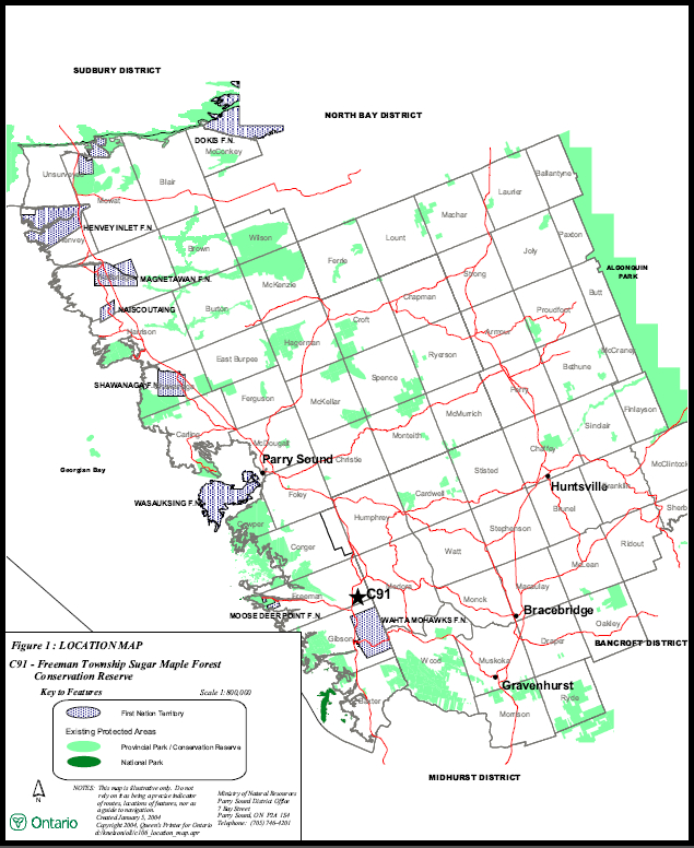
Figure 2: Site Map