French River Provincial Park Management Plan
This document provides direction on the management of French River Provincial Park.
November 1993
©1993 Queen’s Printer for Ontario Printed in Ontario, Canada
For more information or additional copies of this publication contact:
Ontario Ministry of Natural Resources,
199 Larch St.,
Sudbury, Ontario,
P3E 5P9.
Telephone 705-675-4120
Approval statement
We are pleased to approve this revised Management Plan as official policy for the French River Provincial Park. The plan reflects the Ministry of Natural Resources' intent to protect the natural and cultural features of French River Provincial Park while maintaining high quality opportunities for outdoor recreation and heritage appreciation for Ontario’s residents and visitors.
The Park’s original management plan was written in 1986 when the French River became the first Canadian Heritage River in Canada. French River Provincial Park was established in 1989.
The River is unique within Ontario’s Provincial Park system as the largest waterway park draining into the Great Lakes. A drainageway in this part of the Canadian Shield proceeded the last glacial period, which began 45,000 years ago. The Park contains an extensive bedrock delta and a fault controlled main river channel. Shoreline habitats from Georgian Bay to Lake Nipissing including wetlands and upland forests. The waterway is an ancient travel route, which has been used since cultures inhabited this part of Ontario 6,000 years ago. It has been an important recreation and tourism area for 100 years. Today the scenic quality of the River continues to be an outstanding attraction for visitors.
The policies in this Plan are consistent with new implementation details on province wide policies for park planning and management. The policies and direction in the Plan were formed with input from a variety of publics. Ideas for the Park policies were also closely reviewed by an advisory committee, which is comprised of representatives from various interest groups and the Dokis First Nation.
This Plan reaffirms the policies for park planning and management to place a priority on the protection objective for the French River while pursuing the other three objectives for heritage appreciation, recreation and tourism.
A. Stewart
Regional Director
Central Region
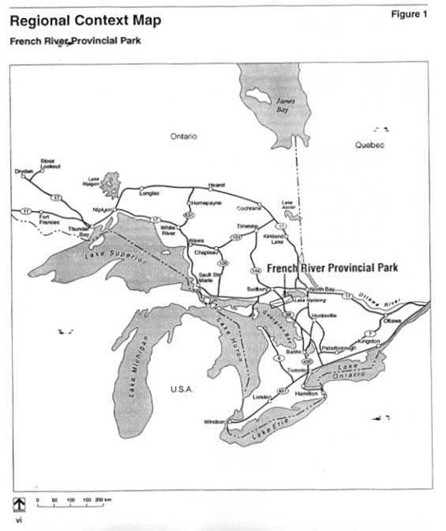
Figure 1: Regional setting
1.0 Introduction
French River Provincial Park will be managed to protect this nationally significant River. It comprises 51,150 hectares, situated 60 kilometres south of Sudbury and 300 kilometres north of Toronto (Figure 1). It flows from Lake Nipissing into Georgian Bay; descending through a series of island-dotted lakes interconnected by channels, rapids and waterfalls. The River is best known as an historical transportation route. Its present use is devoted primarily to water oriented recreational activities such as boating, canoeing and fishing. Although there is considerable cottage, resort and residential development in certain areas, most of the Park is undeveloped. It is the natural quality of the French River, which has remained largely unchanged through time that provides its greatest appeal.
1.1 A significant heritage
The French River contains many significant heritage features that are representative of this area of the Canadian Shield.
The French River lies wholly within rocks of the Grenville Province, which are of Middle to Late Precambrian age (1.6 billion to 900 million years old). Bedrock outcrops along the River display the many characteristics of the Grenville rocks: coarsely recrystalized gneisses with dykes of pegmatites and diabase. Outcrops are characteristically banded and intensely folded in places. Most channels follow fault and fold lines in the bedrock. It is one of a few rivers in Ontario that existed prior to continental glaciation. Continental ice melt in this area 10,000 years ago revealed bedrock controlled channels. Close views of the shoreline show intricately moulded and chattered rock surfaces that have been deeply grooved in some areas. When viewed from the air these sculptured islands on Georgian Bay are oriented parallel to the southward flow of glacial ice creating a striking bedrock delta landform.
The River flows through the Great Lakes St. Lawrence or the Northern Deciduous forests of North America. A variety of vegetation associations have been described for the Park with 450 species of plants documented to date. Rock barrens dominated by open grown pine are the most common plant communities in the Park. Limited pockets of upland hardwood sugar maple, yellow birch and white pine are found on deeper soil sites. Wetlands on the River harbour rare and representative plant species. Osprey and Great Blue Heron nest throughout the Park. Intriguing wildlife such as the Eastern Massasauga Rattlesnake, Wapiti (elk), and Double-crested Cormorants inhabit the mouth area.
The River’s many scenic rapids, chutes and falls were once viewed as obstacles on the exploration and fur trade "route to the west". They are a powerful reminder of the hardships faced by men like Samuel de Champlain and Pierre de La Verendrye as evidenced by many authentic artifacts recovered throughout the River. These same white water sites are an important part of the pickerel habitat that extends out onto the shoals of Georgian Bay.
Aboriginal peoples used the River as a travel route and relied on its productive fisheries while using seasonal campsites. Symbols of these cultures can still be seen at a few small pictograph and petroglyph sites.
1.2 Management planning
The French River Provincial Park Management Plan- provides policies and direction that will guide protection and orderly and effective management of the Park. The policies contained in this Plan are based on the Park’s goal and objectives.
A public advisory group involving representatives of the various users of the River assisted in the development of the 1986 Management Plan. An outgrowth of that advisory group, the Joint Management Committee = advised regional, area and park staff about the planning and management of the River.
Changes made to Provincial Park Policy in 1988 lead to a ministerial commitment for a review of the Management Plan in 1991.
Response to the management plan review
People over and over again raised the concern that the policies in the Plan must reflect the primary objective of protecting the waterway while providing for compatible recreation and tourism uses. The public that commented on the plan pointed out that many of the problems associated with use will continue without sufficient management. The planning and management of the Park will continue to benefit from ongoing input from an advisory committee.
2.0 Park policies
2.1 Park classification
French River Provincial Park is a waterway class park, one of six classes of provincial parks.
Waterway parks are corridors following major water routes and include associated lands that are of particular recreational, historical and natural significance.
French River has several resource and recreational attributes that warrant this special designation. The River is nationally significant as an historic transportation route. It is one of the best examples in Ontario of a preglacial drainage system that is still functioning. Its Woodwardia bogs in the delta may contain the largest population of Virginia Chain Fern in Canada. A provincially significant Eastern Massasauga Rattlesnake and pickerel fishery are noteworthy. The River also provides excellent opportunities for boating and canoeing. Waterway park designation and management reflects a collective vision of residents and visitors that the River’s cultural and natural qualities need to be protected.
The French River Provincial Park Management Plan’s policies comply with waterway class guidelines as set out in the Ontario Provincial Parks Planning and Management Policies (1992). The management plan describes the policies for resource management, client services and Park facilities. The focus of the Plan is on the protection of the waterway environment and existing recreational and resource pursuits. Traditional uses such as boating, fishing and commercial bait fishing will continue. Hunting and snowmobiling will be permitted except within nature reserve zones. Recreation management will support and accommodate canoe tripping and boat-in camping, cruising and mooring. This will involve the provision of directional and educational information; portage and campsite maintenance; and, the establishment of controls as required to protect a high quality park environment.
2.2 A Canadian heritage river
The French Rive r was designated a Canadian Heritage River in 1986.
Canadian Hadtage Rivers are outstanding examples of Canada’s natural heritage, or played a significant role in Canadian history or offer outstanding opportunities for recreation. This national system of protected rivers has emerged over the last two decades as part of a growing concern to ensure that Canadian rivers are managed wisely.
The purpose of the Canadian Heritage Rivers System is to give national recognition to "important" Canadian rivers, to ensure that future management will protect their natural and cultural heritage values while providing opportunities for recreation and heritage appreciation. The Park Management Plan is filed with the Canadian Heritage Rivers Board as part of the requirement s for designation as a Canadian Heritage River. Annual reports on the status of management are submitted to the Board.
2.3 Park goal and objectives
The following are the goal and objectives of the French River Provincial Park.
Goal
To protect the outstanding landscape, natural features, and cultural resources of French River Provincial Park, and to provide high quality recreational and educational experiences.
Objectives
Waterway parks contribute to the achievement of Ontario’s Provincial Park objectives: protection, tourism, recreation, and heritage appreciation.
Park management will respect the rights of landowners adjacent to the Park.
Protection
To protect the natural and cultural environments of the French River.
Protection of the waterway environment is the prime objective, which has priority over all others. Protection of the River’s natural quality is vital to the achievement of other Park objectives. The Park will protect a representative portion of the ancient - biological earth history of the Canadian Shield, modern biological environments and cultural features associated with this area between Lake Nipissing and Georgian Bay.
Tourism
To support the French River tourist industry and encourage its long term viability.
The protection of the natural setting and resources of the River will ensure that tourists continue to enjoy a high quality outdoor environment. The tourism emphasis will be to support the continued viability of the French River tourist industry. Commercial establishments will serve as bases from which to explore the Park.
Recreation
To provide high quality River recreation travel and camping opportunities in an outstanding natural setting.
This will be accomplished by the protection of the Park’s natural environment and the establishment of a recreation management program. The main recreational emphasis of the Park will be on the provision of dispersed recreation opportunities for canoeists and boaters. For the purposes of this plan, this use is referred to as backcountry travel. A target for the number of backcountry opportunities has been identified in Sudbury, Parry Sound and North Bay District Land Use Guidelines (1983). These will be evaluated through the recreation management program and a refined target will be presented, if required, through future plan review.
The management direction will be to maintain low density backcountry travel to ensure high quality experiences while minimizing impact on the Park environment and adjacent private property. The Ministry will support and accommodate canoeing, motorboating, cruising and other traditional River uses. Although some overnight camping and other controls may be established as required, the Park will not impose controls or fees on day use travel.
Heritage appreciation
To provide opportunities for unstructured individual exploration and appreciation of the natural and cultural heritage of the French River.
Due to the importance of the French River to the natural and cultural history of Ontario, heritage appreciation will receive special consideration in Park management efforts. Opportunities will be provided for unstructured individual exploration and appreciation of the natural and cultural heritage of the French River.
2.4 Park boundary
The boundary of the Park includes shorelands on both sides of the River and the waters and all Crown islands between these from Lake Nipissing along the Little French River and Main Channel to the mouth area and the Bustard Islands on Georgian Bay (Figure 2). The Crown shorelands are 200 metres wide above Recollet Falls with the exception of Burnt Island on the Lake Nipissing end where it is 120 metres. The entire bedrock delta is included on Georgian Bay. Privately owned land surrounded by the Park boundary is not included in the Park. As result the 1992 plan review sections of the River shorelands are being evaluated to determine if the Park is wide enough to contain significant vegetation associations.
2.5 Park zoning
Lands and waters within French River Provincial Park are zoned: natural environment, historical and nature reserve zones, and one development zone (Figure 2).
Detailed descriptions of zones are preceded by a general discussion of resource and recreational uses, and the types of facilities permitted on Parklands. Only the main uses of interest are listed there. A more substantive list is provided in the Ontario Provincial Park Planning and Management Policies. Resource and recreational uses will be subject to standard Ministry of Natural Resources regulations and/or French River Provincial Park management policies. These are discussed further in the Resource Management section.
Zone descriptions highlight the location, natural and cultural characteristics, significance and management direction. Statements pertaining t o campsite development potential refer primarily to the designation and management of existing campsites. Subject to the back-country travel target review, it is expected that very few new campsites will be developed along the River.
Natural environment zones
Natural environment zones include sections of the waterway landscape corridor where low density camping occurs. The majority of the Park is zoned to protect the natural environment. The priority for natural environment zones will be resource protect ion followed by recreation management.
Recreational uses:
- canoeing
- motorboating
- hiking
- cross-country skiing
- snowmobiling
- sport fishing hunting
- dispersed camping
- heritage appreciation
- yacht and houseboat mooring
- scuba diving
Facilities :
- trails/portages
- necessary signs for route identification
- access roads (existing only)
- dispersed campsites
- minimal interpretive facilities
- temporary facilities as required for Park research and management
Resource uses:
- commercial fishing (only on Georgian Bay waters as per existing licences)
- commercial bait-fishing
- trapping (non-native commercial trapping to be phased-out by the year 2013)
NE1: Upper French River (7518 ha)
This zone, known as the Upper French River, extends from Lake Nipissing to Chaudière Rapids. It is lake-like in appearance and contains several islands and bays. River aquatic systems, wetlands, immediate shoreline and island plant communities will be protected. Fire origin pine forests dominate shoreline and island plant communities. The zone has many cottages and offers excellent opportunities for boating, yachting, fishing, hunting and canoeing. This zone will be managed to provide dispersed overnight opportunities for small craft boaters, houseboaters, yachters and canoeists. There is some potential campsite development in the zone. Sport fisheries management will be undertaken in conjunction with measures taken for Lake Nipissing.
Figure 2: Park boundary and zoning
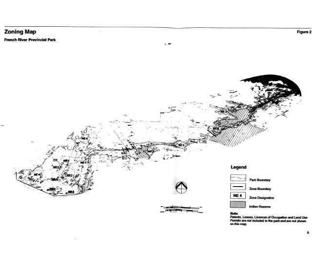
NE2: Chaudière Channel and Little French (3167 ha)
This zone extends from Chaudière Rapids to Five Mile Rapids and includes the Little French River. The majority of the shoreline of this zone is not in the Park as it forms part of the Dokis First Nation Reserve. The Little French River follows a narrow, zigzag folding and faulting pattern of the bedrock. Some glacial potholes, evidence of higher glacial water flows, occur along the Little French River. River aquatic systems, wetlands, immediate shoreline and island plant communities will be protected. Some of the more extensive stands of Cardinal Flower on the River can be seen in this zone. The zone is largely undeveloped and offers an excellent natural setting for small craft boating, fishing, canoeing, hunting and scenic viewing. The Five Finger Rapids on the Little French River is the most scenic attraction of this zone. This zone will be managed to provide dispersed camping and scenic viewing opportunities for canoeists and small craft boaters. There is limited potential for campsite development due to the predominance of First Nation land.
NE3: South Channel (4812 ha)
This zone extends from Five Mile Rapids to the Highway 69 bridge. The eastern portion of the zone is largely undeveloped and natural. A major east-west fault runs from below the Five Mile Rapids to the western end of Eighteen Mile Island. Numerous fault controlled bays occur off the main channel. River shoreline plant communities are typically young open grown pine and cedar forests with scattered poplar and birch. The representation of other forest types in this z one includes mature upland white pine with sugar maple and associations and lowland silver maple swamps. The greatest diversity of plant species documented for the River occurs in this zone. Additional protection to the Park is provided through area of concern designation on adjacent Crown lands. Plant communities represented here will be evaluated to determine if they are adequately represented inside the Park. The western portion of the zone is developed and includes numerous cottages, a transmission line, and railway crossing. This zone offers good canoeing, small craft boating, fishing and hunting opportunities. The most dispersed camping occurs in the eastern portion of the zone.
NE4: Lower French and Mouth Area (34 235 ha)
This zone, the largest in t he Park, extends from Recollet Falls to Georgian Bay. It comprises a series of channels that flow into Georgian Bay. It is the least developed and wildest portion of the River and contains the Park’s nature reserve zones. Among its most interesting features are the River gorge and the confluence of the French, Pickerel and Wahapitei Rivers, the Georgian Bay shoreline and the Bustard Islands. This area is a rock delta of complex fault controlled bedrock channels that were formed in preglacial and glacial times. Shoals, whalebacks and moulded islands occur between low shorelines. Plant communities in this area include a variety of wetlands, open and scattered upland mixed forest and rock barrens. This rugged terrain supports a population of Eastern Massasauga Rattlesnakes. It is a wintering area for moose and elk. This zone offers excellent opportunities for small craft boating and canoeing and good fishing, hunting and wildlife viewing, along with yachting in the bays and channels off Georgian Bay. This zone w ill be managed to protect the intrinsic values of its natural environment and to provide the highest quality waterway experience in the Park. Facilities will be kept to an absolute minimum. Given the size of the area, more River camping may occur here than in other zones, yet use will be at a much lower density than in the rest of the Park.
Nature reserve zones
Nature reserve zones include significant earth and life science features in the waterway corridor, which require management distinct from that in adjacent zones. They comprise five areas, which contain natural features of provincial and/or national significance. Nature reserve zones are for protection, research and heritage appreciation. Resource uses are not permitted. Research proposals will be reviewed through appropriate policies and guidelines. Based on research into the needs of the features to be protected, this zoning may be revised in the future.
Recreational uses:
- heritage appreciation
Facilities:
- existing trail at Coponaning
- portage and existing boat tramway and necessary signs for route identification only in NR3
- minimal interpretive facilities, e.g. outdoor display panels explaining significance of situ
NRI: Virginia Chain Fern Wetlands (14 ha)
This zone comprises two wetland sites situated by the Dallas Rapids and on the Eastern Outlet at the Elbow. The main features of these sites are the nationally significant Virginia Chain Fern and the provincially significant glacial grooving. The zone will be managed to protect the Virginia Chain Fern habitat and the shoreline bedrock surfaces that display glacial grooving.
NR2: Eastern Massasauga Rattlesnake Habitat (6 ha)
This zone is located on the Main Outlet and surrounds the historic Coponaning Townsite. The main feature is the provincially significant Eastern Massasauga Rattlesnake. The zone will be managed to protect rattlesnake habitat - upland mixed forest with natural openings of broken rock exposures and adjoining wetlands. These conditions extend throughout the delta and Bustard Islands. Representative habitat and pressures on rattlesnake populations will be assessed further. This may identify a larger area to protect suitable habitat, which would require enlargement of the zone under a minor amendment to the plan.
NR3: Ice-Moulded Rock Channels (15 ha)
This zone is located at the Bass Creek tramway. Provincially significant glacial grooves and sculpturing occur on the bedrock. The zone will be managed to protect these rock formations. The tramway will be maintained.
NR4: Macoun Rocks (5 ha)
This zone comprises a series of small wave washed bedrock islands called the Macoun Rocks. Plant species rare to Ontario are found here. The zone will protect these species' habitat.
NR5: Gull Rocks (20 ha)
This zone comprises two small rock island groups including the Gull Rocks. They provide nesting sites for the provincially significant Double-crested Cormorants. The colonies also include gull populations. Caspian Terns occur in the area. These sites provide interesting opportunities to study the dynamics of colonial nesting birds and their predators on the Great Lakes. The zone will be managed to protect the nesting sites.
Historical zones
Historical zones include significant cultural resources in the waterway corridor, which require management distinct from that in adjacent zones, and sections where there are outstanding opportunities for identification with historic waterway travelers and their activities. They comprise four sites with historical features of provincial and/or national significance. The priority for historical zones will be protection, heritage appreciation and research.
Recreational uses:
- canoeing and motorboating
- hiking
- cross-country skiing
- snowmobiling (only existing dispersed activity, no designated trails or structures)
- sportfishing
- hunting
- dispersed camping (except for H4)
- heritage appreciation
Facilities:
- trails/portages and an existing boat tramway
- necessary signs for route identification
- dispersed campsites (only in H2)
- visitor information facilities (only in Hi and H3)
- interpretive plaques
- facilities for Park research and management (except in H4)
Resource uses:
- commercial bait-fishing
- trapping (non-native commercial trapprng to be phased-out by the year 2013)
Hi: Chaudière Rapids (295 ha)
This zone is located at the Chaudière Rapids and abuts the Dokis First Nation Reserve. The significance of the site is attributed to the nationally significant voyageur route; regionally significant archaeological sites; rock paintings (pictographs); and a glacial pothole. The zone will be managed to protect and interpret these historical features. Historic plaques and displays may be provided. The two existing bridges will continue but no new structures will be allowed.
H2: Five Mile Rapids (975 ha)
This zone comprises the Five Mile Rapids area. The presence of nine sets of rapids in a short distance reflects complex geological folding and faulting. This very scenic, undeveloped area contains the longest stretch of white water within the French River. Significant historical features include: the nationally significant voyageur route; historic portages; and regionally significant archaeological sites. This zone will be managed to protect these historical features. Historic plaques may be established on portages, however, no displays or other facilities will be developed. Some dispersed campsites will be provided. Recreation management will also occur to ensure that this popular area does not suffer degradation from overuse. Bridges will not be permitted.
H3: Recollet Falls (85 ha)
This zone includes Recollet Falls and immediate surroundings. Significant features include: the nationally significant voyageur routes; the historic Recollet Portage; regionally significant gorge and archaeological sites; rock carvings (petroglyphs); and the scenic falls. The zone will be managed to protect and interpret these historical features. Historic plaques and displays will be provided. Heritage appreciation will be a high priority due to the zone’s proximity to Highway 69 and connection with the DI development zone, which may contain the proposed French River Heritage Centre. The Recollet Falls tramway will be maintained.
H4: Coponaning (2 ha)
This zone comprises the regionally significant historic townsite of Coponaning. Ruins and relics of this abandoned logging town are still in evidence and provide ideal habitat for the Eastern Massasauga Rattlesnake. This zone will be managed to protect Eastern Massasauga Rattlesnake and to interpret the historic townsite. Historical restorations and reconstruction will not be permitted. Camping will not be permitted.
Development zone
Only one development zone occurs in the Park. The Development zone has potential for a major interpretive facility for Park visitors and area tourists. Resource uses are not permitted.
Recreational uses:
- picnicking
- hiking
- heritage appreciation
Facilities:
- picnicking and support infrastructure (i.e. entrance road, parking area, sanitary facilities)
- interpretive building and associated facilities
- highway signs
Dl: Voyageur Lookout (1 ha)
This zone comprises the picnic site at the Highway 69 bridge. It would accommodate the proposed development of a French River Heritage Centre should it become feasible in the future. See Facility section for details.
3.0 Resource management
Resource management of the French River Provincial Park will be carried out in accordance with the Park Management Plan. A Park operating plan has been prepared in keeping with the direction provided in this Plan. The operating plan contains specific operational guidelines on how to carry out the management of the Park’s water, land, natural and cultural features.
3.1 Natural heritage management
The management of natural resources will be directed towards protection and heritage appreciation. Natural heritage sites, particularly those designated as nature reserve zones, and the extensive lands of natural environment zones will be protected. Incompatible resource uses and recreational activities that detract from these sites are prohibited. Where natural heritage features occur on private land along the waterway corridor, the Ministry of Natural Resources will encourage landowners to protect and care for these features.
Significant natural features on Park lands will be monitored. These include Virginia Chain Fern wetlands, Massasauga Rattlesnake populations, Wapiti (elk) range, cormorant nesting sites and rare plants. Management prescriptions and controls will be established as required to ensure their protection. Interpretive information may be provided at some significant sites through outdoor displays. General information will be available in Park literature.
Vegetation management
Commercial forestry operations will not be permitted in t he Park. A Fire Management Plan will be developed to outline priorities in fire response within the Park. Programs may be developed to control forest insects and diseases in the Park where these threaten significant heritage, aesthetic, or economic values . Where control is desirable, it will be directed as narrowly as possible to the specific insect or disease so as to have minimal effects on other components of the Park’s environment. Biological control will be used wherever possible.
Wildlife management
Wildlife will continue to be managed in accordance with policies and regulations prevailing in the area. Commercial trapping will be phased-out of all areas within the Park by the year 2013, with the exception of persons on traplines with First Nation status. Hunting will be permitted except in nature reserve zones. The Ministry will closely monitor the elk population. Elk hunting is not permitted due to the small population. The Ministry will seek to protect Eastern Massasauga Rattlesnake habitat in the Park, and inform and educate Park visitors so as to minimize destruction of snakes and injury to humans. Opportunities for wildlife viewing will be encouraged.
Fisheries management
The fishery will continue to be managed in accordance with policies and regulations prevailing in the area. Commercial fishing is permitted only on the existing licensed areas in Georgian Bay.
- There will be a special emphasis on monitoring and managing the French River fishery to maintain and enhance the health of the fishery and the quality of angling recreation. Specific management direction will be provided in the Sudbury, Parry Sound and North Bay District fisheries management plans.
3.2 Water management
The management of water will promote the maintenance of good water quality and sufficient water flow for fisheries' habitat and recreational purposes.
Development hydroelectric generating facilities will not be permitted within the Park.
The Ministry of Natural Resources will continue to promote good water quality on the French River, and will continue to work with the Ministry of the Environment and other government authorities and landowners to monitor water quality and respond to problem situations.
3.3 Land management
The management of land will be directed towards the maintenance of the natural landscape and riverside environments of the French River.
The existing private land use is very compatible with the French River Provincial Park. As such, private lands will not be expropriated for Park purposes. If a specific patent parcel is desirable for resource protection purposes of Park management a number of alternatives can be examined. Conservation easements may be pursued or lands could be acquired only when offered for sale, and subject to government funding.
Crown land management adjacent to the Park will not detract from Park objectives. Should provincially significant natural resources be found to occur adjacent to the Park their protection may be accomplished through Area of Concern or Areas of Natural and Scientific Interest designation or by expansion of the Park boundary.
In keeping with the Ministry of Natural Resources policies, which have been in place in the French River area for a number of years, there is no intent to dispose of Parkland. However, due to the numerous patent parcels abutting the Park, some land disposition may be required. No disposition will occur if it conflicts with Park values. In no case will Park land be disposed of to other than the adjacent registered landowner, or where it changes the existing use of the adjacent patent hand. Any dispositions that do occur must conform to Ministry policies for Crown land in the area outside of the Park.
Road, rail and utility lines
New roads will not be developed in the Park. Expansion of existing road, rail, and utility line crossings of the French River may be permitted to meet essential public service needs. Before disposing of Parklands for these purposes, the Ministry of Natural Resources will work closely with proponents to ensure that:
- all reasonable alternatives have been considered
- wherever possible, new crossings are located next to existing crossings of the same type;
- impacts on Park heritage values and on the River’s scenic and unspoiled quality are minimized.
Applications for installation of electrical utilities within the Park will be considered. Such applications may be approved if there are no negative impacts to the natural, visual/aesthetic character of the River. The requirements of the Environmental Assessment Act and other pertinent acts will be adhered to.
Solid waste disposal
Efforts will be made to clean up unauthorized dumpsites and to prevent this activity from recurring. Where there is no practical alternative, disposal sites may be considered in the Park but only within natural environment zones and only where there are no negative impacts to the natural, visual/aesthetic character of the River. One authorized site "Keystone dump" is operated in the Park, just east of Satchels Bay. It will continue to function until an alternate facility can be approved.
Mineral exploration
Mineral exploration and development will not be permitted within the Park.
Aggregate
The extraction of aggregate will not be permitted, except for garbage management purposes at the authorized dumpsite as above.
Private lands
Privately owned property within the Park boundary is not part of the Park. Landowners are not restricted in the sale or transfer of private land. There will be no right of first refusal on private lands offered for sale. The use of private lands will continue to he regulated by existing jurisdictions. The Ministry of Natural Resources will continue its formal input role in all plan review and approval on patent lands. First Nations lands do not form part of the Park. Land use on the Dokis and French River First Nations' Reserves will continue to be governed by the Docks and Henvey Inlet First Nations' Councils respectively. While the Ministry of Natural Resources has no formal input into planning and development on First Nations Reserves, the Ministry will seek to maintain a cooperative relationship so as to encourage compatible development of Reserve shorelands.
3.4 Cultural heritage management
The management of cultural resources will be directed to protection and heritage appreciation. The Ministry of Natural Resources will continue to work with the Ministry of Citizenship and Culture to identify archaeological and historical sites, which should be protected along the waterway corridor.
Cultural heritage sites will be protected. Incompatible uses and recreational activities that detract from these sites will be prohibited.
The main historic values include: archaeological seasonal encampment sites; pictographs and petroglyphs; portages along the historic travel routes; underwater canoe spill sites below falls and rapids and at landings; and traditional campsites. These values relate primarily to the River’s long standing use as a transportation route, an activity that is still in place today. In most instances, these values comprise the physical evidence of human impact on the environment and do not require any special protection. Periodic inspections of significant sites will occur with protective controls established as required.
Historical artifacts and constructions such as the pictograph and petroglyph sites and the Coponaning townsite will be closely monitored. The removal of artifacts or destruction of historical features is illegal. Outdoor displays may be provided at significant sites for heritage appreciation. Off-site interpretation of the cultural significance of the French River will be carried out through Park literature.
Where cultural heritage resources occur on private land along the waterway corridor, the Ministry of Natural Resources will encourage landowners to protect and care for these features.
4.0 Client services
Client services will be managed in accordance with this Management Plan. An Operating Plan was approved in 1987 in keeping with the direction provided in the Management Plan. The Operating Plan provides specific operational guidelines on how to carry out client services management. The Ministry will encourage the private sector and the Friends of French River Heritage Park to offer complementary services.
4.1 Visitor services
The primary objective of Visitor Services will be to orient Park visitors to the heritage and recreational attributes of the French River. Self-use approaches, such as publications and displays will be used to deliver Park information, resource interpretation, recreational skills and park management messages.
Park information
A public information program for Park visitors will be established. A Park map has been produced to identify the natural and cultural values and to enable users to safely explore and use the River. Information will be provided that will direct backcountry travelers away from heavily used areas. Low impact camping at dispersed sites will be encouraged. A 'leave no trace' attitude will be promoted in order to minimize human impact on the Park environment.
Visitors will be advised to exercise caution regarding safety hazards. Information will caution visitors regarding travel along the Georgian Bay, particularly as it pertains to severe weather conditions, buoyed yachting routes and exposed open water stretches such as the opening at Dead Island. Visitors will also be informed about avoiding rattlesnakes and measures to take in the event of snakebites.
The importance of respecting other users will be stressed, particularly the rights of private property owners. Park literature will inform visitors about the commercial services and attractions that are available in the area to enhance their stay and generate local tourism expenditures.
Resource interpretation
The natural and cultural history of the French River will be interpreted to the Park visitor through the use of the 'historic transportation" theme. This broad theme encompasses the following sub-themes: "glacial geology"; "the River as a plant and animal migration corridor"; and "water travel". The water travel cultural sub-theme will be divided into the following components; native people; early explorers and missionaries; voyageurs; loggers and farmers; and early tourists. Innovative ways of cooperative portrayal of the River’s broad heritage will be pursued with other agencies and business interests. This could include the construction of a Heritage Centre on Highway 69. Interpretation of historic portages will receive priority.
Recreational skills
Recreation information will acquaint Park visitors with the recreational attributes of the Park and the skills required for minimum impact river travel. The Park map will provide basic information for this purpose. With improved skills, visitors will make better use and enjoyment of the Park while minimizing their impact on the environment.
4.2 Recreation management
The management of recreation will be directed through a comprehensive recreation management program. Low density, backcountry travel along the River with river camping by boat or canoe is a traditional activity associated with fishing and canoe tripping. Access to the River will be through the existing entry locations. A cooperative arrangement will be sought with the private sector to ensure an adequate provision of River access opportunities. Car camping use of the Little French River access point will be monitored and managed as required for proper use with priority given to its boat access function. Car campgrounds will not be established in the Park.
The following are general ground rules that will direct the recreation management program:
- the program will be developed gradually with public involvement and as measures are needed and can be supported;
- low density camping will be maintained on the River;
- Park facilities will be kept to a minimum;
- use of houseboats, yachts, jet skis and boat caches will be reviewed;
- strategies will be developed to integrate all uses to ensure that the objective of protection is not compromised;
- existing effective stewardship activities of River users will be encouraged to continue; and,
- involvement of the public in River management will reduce reliance on limited Ministry funding.
The initial task of the recreation management program will be to determine levels of use and evaluate and refine use targets as presented in the Sudbury, Parry Sound and North Bay District Land Use Guidelines (1983). A multi year user survey was initiated in 1992. The survey will collect important data on the type and density of the variety of uses by River section, user origin, user likes and dislikes, party size, length of stay, main entry locations, and travel routes. In addition, existing and potential camping and mooring sites will be identified. Information will continue to be gathered on the condition of camping, mooring sites and portages. These surveys will assist in determining the River’s actual carrying capacity for use. Based on carrying capacity and space standards, a target for the number of backcountry travel opportunities will be determined. This process will be carried out in the context of the Park Management Plan and may require plan amendment.
Overnight use happens within the Park associated with canoeing, small craft boating, houseboating and yachting. The intent of planning policies is to establish acceptable levels of use wherein Park values are not compromised and high quality diverse recreation activities are maintained. Controls on overnight use will only be required if there are areas deemed to be set aside from this use or if signs of degraded park environments and visitor experiences can be related to overuse. If controls are needed they will be reviewed with the public and gradually phased in and directed at resolving a specific need. Canoe-in and boat-in campsites will be designated by unobtrusive signs. Group camping and mooring will be monitored and restrictions may be established if required to protect the Park environment and the experience of other River users.
Maintenance standards for campsite and day use picnic site clean-up, garbage disposal, portage clearing and signage have been established in the Park operating plan. The feasibility of utilizing the private section and implementing these aspects of the Park operation will be examined. In areas w here firewood is in short supply or during periods of extreme fire hazard, campers may be required to carry portable stoves. In the future, based on the findings of research, restrictions may be placed on overnight stay within the Park.
The pattern of use of three activities is central to understanding the impact of these uses on Park environments and the quality of extensive recreation travel in the Park: houseboats, yachts and personal watercraft. The terms houseboat and yacht are used to describe any boat designed, fitted or employed as a dwelling whether temporary or permanent. This definition includes yachts - sailboats and cruisers. Personal watercraft is a term for a vessel of four meters or less in overall length that is inboard powered, water jet driven and designed to be operated at high speeds while sitting, standing or kneeling on rather than sitting in as in a conventional vessel. Their operation under high speeds and maneuverability within narrow sections of the Park is a concern of other users . The use of personal watercraft will be restricted subject to the terms of the recreation management program which will take into account the protection needs for natural and cultural resources and continued allure and safety of other users of the Park.
Maintaining boat caches on remote lakes by commercial lodges and cottage owners has been a traditional practice. Boat cache use will continue to be permitted until the need for restrictions is identified in the recreation management program.
The measures of the recreation management program will be subject to review.
4.3 Commercial services
The Ministry will work closely with the Ministry of Tourism and Recreation and commercial tourist operators to support the tourist industry and encourage its long-term viability. All facility-based accommodation will be providing the commercial tourist operators and cottagers.
New commercial development on existing private lands will be confined to the minimum that is required having due regard for Park values. Minor proposals to expand existing commercial establishments onto adjacent Parkland will be considered on a case-by-case basis. Such facility expansions would be encouraged to occur in a manner that complements resource protection and recreational use in t he Park.
4.4 Marketing
Peak season marketing and promotion of River camping will be kept to a minimum. Park marketing efforts will be directed at providing park users with quality information about heritage resources and compatible recreation uses. The Ministry will assist in informing park visitors about the services of commercial establishments. In addition to River camping, Park visitors will also be encouraged to use commercial establishments in the off-season as bases from which to explore the Park.
4.5 Co-operative association
A co-operative association; the Friends of the French River Heritage Park, has been established (1992) to assist in the promotion of heritage appreciation within the Park. This group involves resort and property owners and interested persons based on the theme of "shared responsibility" in River management. This association formally recognizes and ensures the continuation of the custodial role that property owners and others have traditionally played in the maintenance of the natural quality of the River.
The Friends' Objectives:
- To encourage and support the goal and objectives of French River Provincial Park.
- To further public awareness, understanding and appreciation of the Park’s natural, historic and cultural resources.
- To organize special events and undertake special projects related to the Park.
- To develop high quality, park-specific, theme-related items and materials for distribution and/or sale to the public.
- To further the objectives of the organization by seeking donations and memberships.
4.6 Scientific research
Scientific research by qualified individuals which contributes to knowledge of natural and cultural history and to environmental and recreational management will be encouraged in the Park. Subjects of particular research interest are: water quality and quantity; fisheries; archaeology, as it pertains to occupation sites; early exploration and fur trade history; significant plant associations, in particular, the Virginia Chain Fern wetlands; and significant fauna such as the Double-crested Cormorants, Eastern Massasauga Rattlesnake habitat and population dynamics; and, Wapiti. All research programs will require Ministry of Natural Resources' approval and must also meet other applicable provincial and federal government requirements.
5.0 Development
New facilities within the Park will be kept to a minimum with the only exception being the small Development Zone. The location, design and materials of all facilities constructed within French River Provincial Park will, to the greatest extent possible, reflect its waterway character. Development will only occur with approved site and development plans. The requirements of the Environmental Assessment Act and other pertinent acts will be adhered to. Once a development is in place, it will be managed according to the Park Operating Plan. The following facilities will be proposed through the Ministry of Natural Resources work program planning and special funding initiatives.
5.1 Park sign system
A sign system will be established to provide a consistent identity and co-ordinated approach to inform and direct visitors to facilities and services offered in the Park. This will involve the integration of provincial highway signs as well as provincial park and heritage River signs. The Ministry of Natural Resources will work with the Ontario Ministry of Transportation and Communications to comply with their guidelines in the case of signs along highways and secondary roads leading to the Park. Campsites and portages along the River will be marked by unobtrusive signs.
5.2 French River Heritage Centre
A heritage appreciation facility would be an appropriate means to inform the Park visitors and travelling public about the national and provincial significance of the French River. The Ministry of Natural Resources will encourage the undertaking of a study to determine the feasibility of constructing a Heritage Centre in the development zone southwest of the Highway 69 bridge. The study would also consider alternative locations along the Highway 69 corridor outside the Park and would evaluate the impact of development on Park use.
This facility would be designed for heritage appreciation based on the "historic transportation theme". Visitors would be introduced to the natural and cultural history of the French River through a variety of means including interactive displays, historic maps, paintings, old photos, historic implements, artifacts, and audio-visual presentations.
This facility would provide tourist information and Park interpretation and would be an attraction along the heavily traveled Highway 69 corridor. It would complement the Science North centre in Sudbury and tie in with historic Fort William in Thunder Bay.
5.3 Historic and nature display exhibits
Some self-use outdoor displays may be developed at natural and cultural heritage sites, e.g. Recollet Falls. Displays would be unobtrusive and intended for educational purposes.
5.4 Dispersed individual campsites
Where required to meet Park objectives, the Ministry will designate campsites along the River once the existing backcountry travel opportunity target has been evaluated. The vast majority will be existing sites; however, a few new sites may be developed. The rights of adjacent property owners will be respected in the designation of campsites. Some existing sites may be temporarily or permanently closed.
5.5 Portages
Some portages may be rerouted if deemed necessary for public safety, etc. The two existing tramways in the H3 and NR3 zones will be maintained. No additional tramways will be constructed.
6.0 Plan implementation and review
6.1 Plan implementation
Implementation of the management plan will involve resource protection, client services, and the development of approved facilities. Implementation of the plan will be based on work program planning and funding.
The following briefly summarizes the main priorities-for implementation over the next ten (10) years.
Resource protection
This will involve:
- protection of significant Park features: bedrock delta and ice moulded rock landforms; Eastern Massasauga Rattlesnake habitat; Double-crested Cormorant, Osprey and Great Blue Heron nesting sites; Virginia Chain Fern wetlands; aquatic, shoreline and upland vegetation associations; the habitat of several rare plant species; seasonal range of Elk; and, the historic Coponaning townsite, pictographs and petroglyphs, portages and rapids
- input into resource management plans for Sudbury North Bay and Parry Sound Districts
- resource inventory and monitoring of earth and life science and cultural heritage values
- development of a Fire Management Plan
Areas identified in the Plan review (199110 1993) as potentially contributing to the Park’s biological representation will be evaluated and as warranted the best mechanism for protection will be implemented.
Client services
This will involve:
- an information, interpretation and outdoor education program for Park visitors;
- user surveys and campsite inventories; campsite and portage maintenance; public relations and enforcement.
Recreation management program
A recreation management program, tailored to the specific needs of the different zones of the River will be developed to describe acceptable limits for the following:
- ongoing baseline and follow-up recreation survey needs;
- Park entry location’s identification (continuing private sites and one public location)
- dispersed individual camping, portages and tramways;
- hazardous small craft boating and swimming areas;
- trails;
- houseboat and yacht use and support;
- limitations on personal watercraft use;
- boat cache use,
- snowmobile use.
Facilities
The following facilities will be developed as funds permit:
- Park sign system;
- historic and nature display exhibits;
- dispersed individual campsites;
- portages (if required);
- possible development of French River Heritage Centre.
6.2 Plan review
This version of the French River Provincial Park Management Plan and implementation of it’s policies may require that other management plans and documents be amended to reflect the policies in the Park Management Plan (Timber Management Plans, Fisheries Management on Lake Huron). Other resource management plans must complement the overall objectives and policies in the Park Management Plan. Where discrepancies occur, the Park Management Plan will take precedence.
To ensure that park management plans keep pace with changing needs, plan reviews are undertaken every 10 years, or as the need arises. Additional research may be conducted on natural and cultural resources and park users as funds and priorities permit.
A plan review will result in a re-written management plan where required. All management plan reviews are approved by the Regional Director and the Director of the Provincial Parks and Natural Heritage Policy Branch.
Plan amendment
During the term of any park management plan, circumstances may require the plan to be amended. This can be done if the proposed changes do not alter the overall intent of the plan and are consistent with the Park’s classification, zoning, goal and objectives. Proposed changes must conform to existing management policies and would not affect specific park targets.
If the Ministry of Natural Resources staff or the public wishes to seek an amendment to the Park Management Plan, an explanation of the requirements for, and nature of, the proposed amendment must initially be submitted to the Regional Park Operations Manager, who deter mines whether the proposed amendment should proceed. If the Regional Park Operations Manager’s decision is favourable, the planning, review and approval requirements for the amendment will depend on whether the proposed amendment is considered to be major or minor.
Minor amendment
A minor amendment would involve changes to development or management policies that are housekeeping in nature. Examples would include the addition of a new nature reserve zone or historical zone based on new information; a change in emphasis in the visitor services program; changes to development concepts; etc.
Minor amendments do not require public consultation, but must be kept on file in the Park Office as a matter of record. Minor amendments will be brought forward for public information during a future plan review. Minor amendments are reviewed by the Regional Director and approved by the Regional Park Operations Manager.
Major amendment
A major amendment is characterized by a proposed change that would have a potentially significant impact on the environment; involves a contentious issue; affects or conflicts with park users; or, is likely to result in significant public reaction locally, regionally or provincially. Examples would include a major tourist development proposal, changes to the hunting area or alteration of resource management objectives.
A major amendment requires public consultation and will result in an addendum to the original plan consisting of the revised policies. Major amendments are approved by the Regional Director.
7.0 Select references
Brunton, D.F., French River: Life Science and Interpretive Potentials. CHRS Pilot Study. Phase I, OMNR, Sudbury: 1979.
Coopersmith, P., French River: Man-Made Heritage Resource Identification and Evaluation. CHRS Pilot Phase II, OMNR, Sudbury: 1979.
Huang, J.C., French River: Landscape Evaluation. CHRS Pilot Study Phase I, OMNR, Sudbury: 1979.
Kershaw, W.L., French River: Preliminary Assessment of Recreation-Tourism and Other Uses. CHRS Pilot Study. Phase II, OMNR, Sudbury: 1979.
Kershaw, W.L., French River: Summary of Resource Significance and Planning Issues CHRS Pilot Study. Phase II, OMNR, Sudbury: 1979.
Kershaw, W.L., French River: Directions for the Future. CHRS Pilot Study Phase III, OMNR, Sudbury: 1980.
McKenzie, D.L. French Riven Assessment of Earth Science Processes and Features CHRS Pilot Study. Phase 1, OMNR, Sudbury: 1979.
Ontario Department of Lands and Forests, North Georgian Bay Recreational Reserve: A Summary Report, ODLF, Toronto: 1971.
Ontario Ministry of Natural Resources, French River Management Plan Review - Phase III: Preliminary ~ OMNR, Sudbury: 1992
Ontario Ministry of Natural Resources, French River Management Plan Review - Phase II: Issues and Policy Options OMNR, Sudbury: 1992
Ontario Ministry of Natural Resources, French River Management Plan Review - Phase I: Background Information and Issues, OMNR, Sudbury: 1991.
Ontario Ministry of Natural Resources, Sudbury District Fisheries Management Plan, OMNR, Sudbury: 1990.
Ontario Ministry of Natural Resources, Georgian Bay Crown Management Unit Timber Management Plan: 12 QA, OMNR, Parry Sound.
Ontario Ministry of Natural Resources, Trout Lake and Killarney Crown Management Unit Timber Management Plan 1990 -1995, OMNR, Sudbury.
Ontario Ministry .of Natural Resources, French River Provincial Park Operating Plan, OMNR, Sudbury: 1987.
Ontario Ministry of Natural Resources, Northbay District Fisheries Management Plan, OMNR, North Bay: 1986.
Ontario Ministry of Natural Resources, French River Provincial Park Management Plan , OMNR, Sudbury: 1985.
Ontario Ministry of Natural Resources, Public Involvement Summary of French River Candidate Provincial Waterway Park Management Plan, OMNR, Sudbury: 1985.
Ontario Ministry of Natural Resources, French River Candidate Provincial Waterway Park Management Plan, OMNR, Sudbury: 1984.
Ontario Ministry of Natural Resources, Sudbury District Land Use Guidelines , OMNR, Sudbury: 1983.
Ontario Ministry of Natural Resources, North Bay District Land Use Guidelines , OMNR, North Bay: 1983.
Ontario Ministry of Natural Resources, Preliminary Evaluation of Ontario Waterways for Provincial Park Purposes OMNR, Toronto: 1978.
Parks Canada, Guidelines for the Preparation of the Canadian Heritage Rivers System Management Plan, Parks Canada, Ottawa: 1980.
Parks Canada, Canadian Heritage Rivers System: Concept Outline, Parks Canada, Ottawa: 1979.
Provincial Parks and Natural Heritage Policy Branch, Provincial Park Planning and Management Policies (update), OMNR, Toronto: 1992.