Friday and Scotia Lakes Conservation Reserve Management Statement
This document provides policy direction for the protection, development and management of the Friday and Scotia Lakes Conservation Reserve and its resources.
Statement of Conservation Interest
Ontario Ministry of Natural Resources
Information and Resource Management, Sudbury District
January 2006
Ce document est seulement disponsible en anglais.
Approval statement
I am pleased to approve this Statement of Conservation Interest (SCI) for Friday and Scotia Lakes Conservation Reserve (C327).
Friday and Scotia Lakes Conservation Reserve consists of two lakes surrounded by a 120 meter wide area. Both lakes contain lake trout and have archaeological and cultural significance. Friday Lake is important for local recreational users, while Scotia Lake is managed for lake trout and remote tourism with fly-in access only. The main forest communities surrounding the lakes consist of white birch, poplar, black spruce and jack pine. Regulated on November 22, 2002, this 1,930-hectare conservation reserve is situated in Scotia, Dunbar, Rhodes and Botha townships and is located in Sudbury and Timmins OMNR Districts.
Direction for establishing, planning and managing conservation reserves is defined under the Public Lands Act, the Crown Land Use Policy Atlas, the Ontario’s Living Legacy Land Use Strategy and other applicable policies. The specific direction for managing this conservation reserve is in the form of a basic SCI, which defines the area to which the plan applies, provides the purpose for which the conservation reserve has been proposed, and outlines the Ministry of Natural Resources' management intent for the protected area. This SCI has been created with input from program specialists within the Sudbury and Timmins Districts. It will provide both the foundation for the continued monitoring of activities and guidance for the management of the conservation reserve. More detailed direction is not anticipated at this time. However, should significant facility development be considered or complex issues arise requiring additional studies, more detailed management direction in the form of special protection measures, or a detailed Resource Management Plan, will be prepared with full public consultation.
Public and Aboriginal consultation occurred prior to the regulation of this conservation reserve. Additional public and aboriginal consultation provided stakeholders an opportunity to comment on the draft SCI, which began in November 2004. Following the completion of this consultation period, additional changes were made to the draft SCI and the associated Crown Land Use Policy Atlas Policy Report for this site. A second public and aboriginal consultation period, related to the revised draft SCI and the associated amendments, took place between February and March 2005. Comments from both reviews have been considered in the finalization of this document.
The management guidelines outlined in this SCI will be implemented by the Sudbury Area Supervisor, and will be reviewed every five years and amended as required by the Sudbury District Planner in consultation with the Timmins District Planner Ministry of Natural Resources.
Prepared by: Rebecca Zeran and Mike Jackson (Crown Land & Protected Areas Planning Assistants) Recommended for Approval by:
Signed by: Stephen DeVos
Sudbury Area Supervisor
Date: Jan. 31, 2006
Signed by: David King
A/District Manager Sudbury
Date: Jan. 31, 2006
Signed by: Rick Carbino
Watershed Area Supervisor
Date: Feb. 9, 2006
Signed by: Randy Pickering
A/District Manager Timmins
Date: Feb. 7, 2006
Approved by: Rob Galloway
Regional Director, Northeast Region
Date: Feb. 21, 2006
Executive summary
The purpose of this Statement of Conservation Interest is to identify and describe the natural, recreational, and cultural values of Friday and Scotia Lakes Conservation Reserve and to outline and guide the Ministry of Natural Resources' management intent for this area.
Friday and Scotia Lakes Conservation Reserve consists of two lakes surrounded by a 120 meter wide area. Both contain lake trout and have archaeological and cultural significance. Friday Lake is important for local recreational users, while Scotia Lake is managed for lake trout and remote tourism with fly-in access only. The main forest communities surrounding the lakes consist of white birch, poplar, black spruce and jack pine. Regulated on November 22, 2002, this 1,930-hectare conservation reserve is situated in the Townships of Scotia, Dunbar, Rhodes and Botha and is located in Sudbury and Timmins OMNR Districts.
Table 1: Administrative details for Friday and Scotia Lakes Conservation Reserve (C327).
| OMNR Administrative Region/District/Area | Northeast Region/Sudbury District/Sudbury Area and Timmins District/Watershed Area |
|---|---|
| Site Region – Site District (Hills 1959) | 4E-3 |
| Ecoregion – Ecodistrict (Crins and Uhlig 2000) | 4E-3 (Mississagi) |
| Township | Scotia, Dunbar, Rhodes, Botha |
| Topographical Map Number & Name | 41P/03 Thor Lake 41I/14 Venetian Lake |
| UTM Co-ordinates | Zone 17 (NAD 83) 472281 E, 5208522 N |
| Latitude/Longitude | 47° 01 '51" N / 81 ° 22 '03" W |
| OBM Numbers | 2017470051900, 2017470052000, 2017470052100 |
| Nearest Town | Cartier, Levack |
| Altitude | 400-460 m |
| Area | 1,930 ha |
| Wildlife Management Unit | 39 |
| Forest Management Unit | Spanish Forest |
| Watershed | Lake Huron basin 2CF and 2DA |
| Regulated | November 22, 2002 |
| Ontario Gazette | December 7, 2002 |
| SCI Completed | January 30, 2005 |
1.0 Introduction
The following document is a Statement of Conservation Interest (SCI) for Friday and Scotia Lakes Conservation Reserve (C327). The purpose of this SCI is to identify and describe the natural, recreational, and cultural values of Friday and Scotia Lakes Conservation Reserve and to outline the Ministry of Natural Resources' management intent for this area. The first three sections of this document highlight the provincial context in which it was produced, state its goal and objectives, and summarize the planning process for conservation reserves. Sections 4.0 through 7.0 are specific to Friday and Scotia Lakes Conservation Reserve and provide background information and management direction for the site. Section 8.0 outlines the requirements for continued implementation and review of this document.
Management direction specified in this SCI will serve to protect the conservation reserve for the benefit of all Ontario residents. This direction will comply with the land use intent and guidelines stated in the Crown Land Use Policy Atlas (CLUPA) on the internet at /page/crown-land-use-policy-atlas. The CLUPA is a consolidation of existing local land use policies for Crown lands within the Ontario Living Legacy Land Use Strategy (LUS) (1999) planning area, an area that covers 45 percent of the province and that extends from Lake Simcoe in the south to the Albany River in the north. Additionally, this conservation reserve will be managed under the Public Lands Act (R.S.O. 1990, c.P.43), and will comply with all legal requirements as specified under the Environmental Assessment Act (R.S.O. 1990, c.E.18).
Friday and Scotia Lakes Conservation Reserve consists of two lakes surrounded by a 120 meter wide area. Both lakes contain lake trout and have archaeological and cultural significance. Friday Lake is important for local recreational users, while Scotia Lake is managed for lake trout and remote tourism with fly-in access only. The protection of these features is considered paramount and future management decisions that affect these values will require a thorough evaluation to ensure that the values remain protected.
The Ontario Ministry of Natural Resources, Sudbury District (Sudbury Area) and Timmins District (Watershed Area) will be responsible for implementing the management policies and guidelines for Friday and Scotia Lakes Conservation Reserve. Their primary role will be to provide public information and compliance monitoring to ensure adherence to current policies and guidelines.
2.0 Goal and objectives of the SCI
2.1 Goal
The goal of this SCI is to provide the framework and the direction to guide management decisions affecting Friday and Scotia Lakes Conservation Reserve.
2.2 Objectives
The following objectives are identified as the means to achieve the above stated goal:
2.2.1 Short term objectives
- To describe the site’s current state of the resource in terms of its values and existing uses and activities
- To outline the Ministry of Natural Resources' management intent for the protected area
- To determine the land use compatibility of current land uses, and to develop specific guidelines and prescriptions to manage these uses
- To provide direction for the evaluation of proposed new uses or economic ventures subject to the Class Environmental Assessment (EA) for Provincial Parks and Conservation Reserves
2.2.2 Long Term Objectives
- To maintain the conservation reserve in a natural state
- To identify research and/or monitoring strategies that may contribute to sound long-term management of the conservation reserve
- To create public awareness of the values within this conservation reserve by providing information on the resources it contains and protects, and to support responsible stewardship through partnerships with local stakeholders
3.0 Management planning
3.1 Provincial context
Ontario’s network of protected areas has been established to conserve representative areas of the province’s natural diversity (which includes species, habitats, landforms, and ecological systems). Protected natural heritage areas are a key component in the sustainable management of natural resources, ensuring that representative sites within the larger managed landscape are retained in as natural a state as possible.
On July 16, 1999, the Ontario’s Living Legacy Land Use Strategy (LUS) (OMNR 1999) was released to guide the planning and management of much of Ontario’s Crown lands. Extensive consultation was conducted during the development of the LUS. The objectives of the LUS were to complete Ontario’s system of parks and protected areas; recognize the land use needs of the resource-based tourism industry; provide forestry, mining and other resource industries with greater certainty around land and resource use; and, enhance hunting, angling and other Crown land recreational opportunities.
These areas are considered to have significant features and values or are representative of major landforms and vegetation types. As such, they require protection from incompatible activities in order for their values to endure over time. The Friday and Scotia Lakes Conservation Reserve was created during this expansion and now forms part of Ontario’s network of natural heritage areas. Both contain lake trout and have archaeological and cultural significance. Friday Lake is important for local recreational users, while Scotia Lake is managed for lake trout and remote tourism with fly-in access only. The main forest communities surrounding the lakes consist of white birch, poplar, black spruce and jack pine.
The Ontario Ministry of Natural Resources has established conservation reserves as a tool to protect natural heritage values on Crown lands, while permitting most traditional Crown land uses to continue. These uses include recreational activities, such as hunting and fishing. Lands designated as conservation reserves in the LUS (OMNR 1999) are removed from the Sustainable Forest License area and mining and surface rights are withdrawn from staking under the Mining Act (RSO 1990 Chapter M.14).
The CLUPA, available on the internet at /page/crown-land-use-policy-atlas, is a consolidation of existing Crown land use policies and is now the official source for guidance on the management of Crown land and protected areas.
3.2 Planning for a Conservation Reserve
The planning process for a conservation reserve consists of regulating the site and preparing a site-specific management plan. Consultation with the public, aboriginal communities and industry occur during site identification, boundary finalization, and management planning. Regulation of a conservation reserve involves the preparation of a legal description of site boundaries, the removal of the site from the Sustainable Forest Licence area, and the withdrawal of the site from staking under the Mining Act (RSO 1990 Chapter M.14). Once a conservation reserve is regulated, the level of management planning required to fulfill the protection targets is determined, and a basic Statement of Conservation Interest (SCI), enhanced SCI or a Resource Management Plan (RMP) is prepared.
A basic SCI is prepared when there is no deviation from the land use direction provided in the LUS (OMNR 1999) and there are few to no issues that require resolution. Alternatively, a RMP is prepared in situations where one or more complex issues have to be addressed, and/or where there is widespread public interest in a site. An enhanced SCI is an intermediary document which is used when a site requires more detailed management direction than would be provided by a basic SCI, but does not have issues significant enough to warrant the preparation of a RMP. Whichever the determination, the plan should be completed within three years of the conservation reserve’s regulation date. The guidelines for the preparation of these documents are provided in Procedural Guidelines A – Resource Management Planning (OMNR 1997a) and the Northeastern Region Guidelines on the Planning Process for Conservation Reserves: Statement of Conservation Interest and Resource Management Plan (Thompson 2001).
A SCI is a management plan guided by the policy direction contained in the CLUPA. The purpose of a SCI is to identify the state of the resource in terms of the site’s values and its current land use activities, and to outline the Ministry of Natural Resources' management intent for the conservation reserve. Basic SCIs typically have a 30-day public consultation period, whereas enhanced SCIs and RMPs have a longer consultation period. Upon completion of this public review, the SCI or RMP is revised as necessary and approved by the Regional Director, MNR Northeast Region.
Existing permitted uses within conservation reserves may continue, unless they are shown to have a significant negative impact on the values protected by the site. A review/evaluation mechanism is in place to address new permitted uses or land use proposals. The subject to the Class Environmental Assessment (EA) for Provincial Parks and Conservation Reserves will be used to screen most project proposals and management activities occurring within the conservation reserve.
Where cultural resources may be impacted, proposals may be screened through Conserving a Future for our Past: Archaeology, Land Use Planning & Development in Ontario, Section 3 (MCzCR 1997).
Public comment may be solicited during a review of any future land use proposals that require new decisions to be made. Appropriate Environmental Assessment Act (R.S.O. 1990, c.E.18) requirements and amendment processes (e.g., Environmental Bill of Rights posting, CLUPA amendment) will apply to any future proposal and/or any significant change in management direction being considered for a site.
3.3 Planning process for Friday and Scotia Lakes Conservation Reserve
3.3.1 Boundary refinement and regulation
The Friday and Scotia Lakes Conservation Reserve was proposed as a conservation reserve in the LUS (OMNR 1999). A letter, fact sheet and proposed boundary map were mailed to stakeholders and to interested members of the public during the boundary consultation process. Consultation occurred with the general public, Aboriginal communities, and industry, and the boundary of the site was regulated through an amendment to Ontario Regulation 805/94 of the Public Lands Act on November 22, 2002, by Ontario Regulation 313/02. The official Ontario Gazette amendment is available on the internet at http://www.ontariogazette.gov.on.ca/ in volume 135, issue 49 on December 7, 2002.
3.3.2 Planning Area
The planning area for this SCI consists of the regulated boundary for Friday and Scotia Lakes Conservation Reserve (see Figure 1). However, to fully protect values within the conservation reserve, the area beyond the regulated boundary may require additional consideration through landowner outreach programs when adjacent land uses pose potential negative impacts on the conservation reserve. Crown land areas beyond the regulated boundary may also require additional consideration when larger land use planning initiatives, such as forest management planning, pose potential negative impacts on the site. Section 5.3.3- Ecological Considerations and section 7.0- Recommendations discuss management implications with areas outside the regulated boundary.
3.3.3 Consultation and significant land use issues
During preparation of the preliminary draft Statement of Conservation Interest (SCI) no significant issues related to land use in this area were identified. For that reason, it was determined that a basic SCI adequately identified the site’s significant features and served as the appropriate format for providing management direction. Following preparation of the preliminary draft SCI it was noted that there were land use issues that would need to be dealt with during planning, and resolution of these issues would need to be consulted on, and incorporated into the final SCI. This document only addresses those issues or land use proposals currently known to the Ministry of Natural Resources, Sudbury District and Timmins District. The direction provided by this SCI, and future management decisions, will work to resolve any potential land use conflicts and ensure that identified values continue to be adequately protected.
This SCI has been created with input from program specialists from the area, district, regional and provincial levels of the Ministry of Natural Resources. Local and regional stakeholders as well as Sudbury area First Nations were provided the opportunity to comment on the preliminary draft SCI. Public consultation took place November 12, 2004 to December 13, 2004. First Nation consultation took place between November 12, 2004 and January 12, 2004. During the notification period it became apparent that the management prescriptions for the northern portion of Friday and Scotia Lakes Conservation Reserve had not been incorporated into the policy report and consequently the draft SCI. Following consultation, a proposal was initiated to edit the Crown Land Use Policy Atlas through a minor amendment to incorporate these changes. These changes were concurrently incorporated into a revised SCI with many of the other changes recommended by stakeholders during the review of the preliminary draft SCI. A second consultation period was held to review the proposed amendment to the policy report and review the revised second draft SCI. Local and regional stakeholders as well as First Nations were notified via mailout in both the Sudbury and Gogama areas. The consultation period took place between February 14, 2005 and March 15, 2005. Newspaper ads were also posted the week for February 7, 2005 in both Sudbury and Timmins and an Environmental Bill Rights (EBR) posting was also posted from February 11, 2005 to March 13, 2005. All comments that were received were considered in the refinement of this document and the proposed policy report.
4.0 Background information
4.1 Location and site description
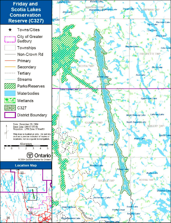
The Friday and Scotia Lakes Conservation Reserve is located approximately 53 kilometers northwest of the City of Greater Sudbury. The conservation reserve is situated 9 kilometers east of the Onaping Lake Conservation Reserve, and 33 kilometers east of Spanish River Provincial Park. Supplies, food and accommodation can be obtained in the Towns of Cartier, Levack or in the City of Greater Sudbury. Figure 1 illustrates the general location of the Friday and Scotia Lakes Conservation Reserve.
Figure 1: Site location map for Friday and Scotia Lakes Conservation Reserve.
Enlarge figure 1: Site location map for Friday and Scotia Lakes Conservation Reserve.
Whenever possible, recognizable natural and cultural features, such as creeks, shorelines or old roads were used to delineate conservation reserve boundaries to facilitate on-the-ground identification. The entire conservation reserve is surrounded by Crown land. The boundaries of the conservation reserve are comprised mainly of a 120-meter wide area around the shoreline of Friday and Scotia Lakes.
The conservation reserve consists of two lakes (Friday Lake and Scotia Lake) and an approximately 120 meter wide area surrounding these lakes. Friday Lake can be accessed by turning east on the Camp 700 road from Highway 144 and then following a series of secondary/tertiary roads towards Mule Lake, and up along Towchain Lake, Sandfly Lake, South Lake and North Lake. The Friday Lake access point is located at the south end of the lake; however, restrictions regarding camping and parking near the lake’s access point exist (see Section 6.3.1a - Roads). Scotia Lake can only be accessed via air or by canoe.
Friday and Scotia Lakes Conservation Reserve is located within Ecodistrict
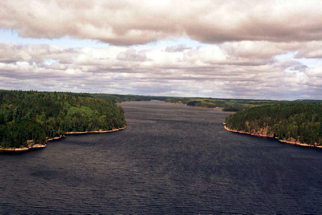
Figure 2: An aerial photo of the northern portion of Scotia Lake. Photograph B. Burkhardt, August 27/03
4.2 Site History
Friday and Scotia Lakes have traditionally been used for hunting and fishing. Much of the forest area in this Ecodistrict has been influenced by logging operations since the turn of the century. Forest fires occurred at the north end and east side of Scotia Lake in 1923 and 1932 (Burkhardt et al. 2004). Cultural heritage values have also been identified within the conservation reserve, suggesting Aboriginal people have used the lakes historically.
4.3 Socio-economic interest
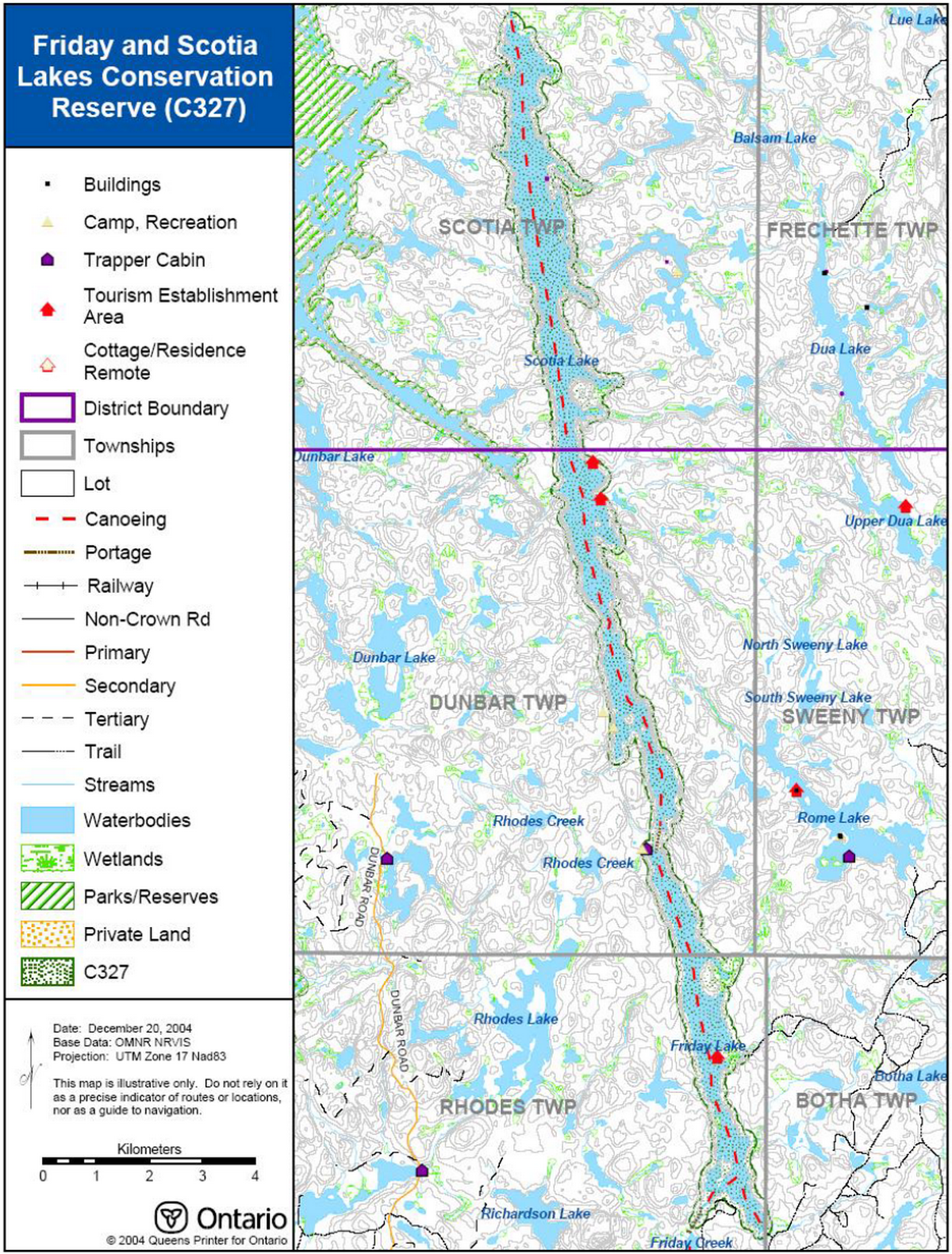
The Friday and Scotia Lakes Conservation Reserve is located reasonably close to the municipality of the City of Greater Sudbury, allowing local recreational users access to the lake. The conservation reserve can be considered relatively remote, especially the northern portion of the site, and thus provides excellent opportunities for commercial tourism. Several outpost camps operate on Friday and Scotia Lakes and provide fly-in access to hunters, anglers and tourists. Two bear management areas (BMAs) and four traplines exist in the site. Hunting is also a long-standing traditional activity in this area. These activities are a vital part of the local economy. The conservation reserve is also located along a provincially recognized canoe route.
The designation of this area as a conservation reserve allows for the permanent protection of the province’s natural heritage values. Friday and Scotia Lakes Conservation Reserve consists of the two lakes surrounded by a 120 meter wide area. Both lakes contain lake trout and Scotia Lake has archaeological and cultural significance. The main forest communities surrounding the lakes consist of white birch (Betula papyrifera), poplar (Populus species), black spruce (Picea mariana) and jack pine (Pinus banksiana).
The conservation reserve lies within the Robinson-Huron Treaty Area of 1850. Protection of this area ensures that activities traditionally carried out by First Nation communities in both the Sudbury and Gogama areas will continue. The protection of this area as a conservation reserve and this Statement of Conservation Interest are not meant to infringe on Treaty and Aboriginal Rights.
4.4 Inventories
Table 2 indicates the current status of natural heritage inventories that have occurred for Friday and Scotia Lakes Conservation Reserve. Recommendations for future inventory needs are located in Table 3, subsection 7.0- Recommendations.
Table 2: Inventory and survey information for Friday and Scotia Lakes Conservation Reserve.
| Type of Inventory | Inventory Method | Date(s) of Inventory | Report |
|---|---|---|---|
| Life Science | Aerial reconnaissance | 27 Aug. 2003 | Burkhardt B., Shaver M. and Longyear S. 2004. Friday and Scotia Lakes Conservation Reserve (C327) Natural Heritage Area - Life Science Checksheet. Unpublished Information. Ontario Ministry of Natural Resources. |
| Earth Science | Aerial photo interpretation | May 2004 | Kristjansson, R.J. 2004. Earth Science Inventory Checklist for C327 Friday and Scotia Lakes Conservation Reserve. Unpublished Information. Ontario Ministry of Natural Resources. (In prep.) |
| Recreation | Ground and aerial reconnaissance | Air: 27. Aug. 2003 | Zeran, R. and Jackson, M. Friday and Scotia Lakes Conservation Reserve (C327) Recreation Resource Inventory Report. Unpublished Information. Ontario Ministry of Natural Resources. |
5.0 State of the resource
Descriptions in this section are not necessarily complete. If new key values or otherwise are identified, they will be added to this document as an amendment. If any new value is considered significant, management guidelines may be modified, if required, to ensure its protection.
5.1 Key values
Key values are values that make this site unique and have led to its designation as a conservation reserve. Their protection is paramount. The key values of Friday and Scotia Lakes Conservation Reserve includes the following:
- Two lake trout lakes providing habitat for fish and wildlife, as well as excellent recreational and tourism opportunities
- An area of cultural/archaeological significance along the shoreline of the two lakes
- Habitat for moose (aquatic feeding areas in bays and late wintering area in forest along the mid-eastern border of the conservation reserve)
- Friday and Scotia Lakes are located along a provincially significant canoe route
Additional values, listed in subsection 5.2- Natural Heritage Values, are also important features and activities identified within the site.
5.2 Natural heritage values
5.2.1 Earth science values
5.2.1a Regional landforms
Friday and Scotia Lakes Conservation Reserve is found within Mississagi Ecodistrict 4E-3 of Ecoregion 4E (Lake Timagami) (Hills 1959; Crins & Uhlig 2000). Ecodistrict 4E-3 is characterized by bedrock covered with stony/sandy till along with frequent flats and ridges of water-laid sand (Burkhardt et al. 2004). Materials are commonly of granitic origin with a few local areas of low-base materials (Burkhardt et al. 2004). Landforms include Precambrian hills mantled by rolling till which are dissected by deep fault valleys in the west and east; the central portions are sectioned with moderately developed valleys that grade into a sedimentary Palaeozoic plain in the northeastern corner (Burkhardt et al. 2004). The conservation reserve is also located within section L.9 (Timagami) of Rowe’s (1972) Great Lakes – St. Lawrence Forest Region. Topography in the western portion is moderately rolling, while in the east, it is more rugged and broken (Burkhardt et al. 2004). Hills are usually covered with shallow till, but the section also has extensive areas of exposed bedrock (Burkhardt et al. 2004). Soils are sandy and gravelly and are of glaciofluvial and fluvial origin (Burkhardt et al. 2004). Rock-cored drumlins are present in the western and eastern parts of this section (Burkhardt et al. 2004).
5.2.1b Surficial geology
The conservation reserve is composed mainly of Bedrock-Drift Complex (Unit 2). Localized organic deposits (Unit 9) are also present. At the north end of the site, areas of either ice-contact stratified drift (Unit 4) or sand-gravel glaciofluvial outwash drift (Unit 5) deposits occur (Kristjansson as cited in Burkhardt et al. 2004).
5.2.1c Bedrock geology
The Friday and Scotia Lakes Conservation Reserve is underlain by undifferentiated grantitic rocks of the Abitibi Subprovince, Superior Province, Precambian Shield (Kristjansson 2004).
5.2.2 Life science values
5.2.2a Regional ecology
The conservation reserve is found in Ecoregion 4E (Lake Timagami) (Hills 1959; Crins & Uhlig 2000). Vegetation in this region is typically boreal with pine being a common component of well to excessively drained sites. Red pine (Pinus resinosa) is common on the shallow exposed ridges and white pine (Pinus strobus) can be found on the deeper more retentive sites. Jack pine can be found in areas recently disturbed by fire. Forest climate for this area is moist-humid, warm-boreal. The Ecoregion is located in the transitional zone between the Boreal and Great Lakes-St.Lawrence Forest Regions and contain a variety of vegetation species from both regions throughout (Burkhardt et al. 2004). The area is also located in section L.9 (Timagami) of Rowe’s (1972) Great Lakes – St. Lawrence Forest Region. This section commonly consists of eastern white pine with scattered white birch and white spruce (Picea glauca) (Burkhardt et al. 2004). Another common forest type includes a mixture of white birch, white pine, white spruce, balsam fir (Abies balsamea), trembling aspen (Populus tremuloides) and largetooth aspen (Populus grandidentata) (Burkhardt et al. 2004). Red pine is often prominent in bluffs along ridges and jack pine is usually restricted to dry sandy or rocky sites (Burkhardt et al. 2004). The prevalent forest cover in upland areas of this section is generally white pine, red pine and jack pine, mainly due sandy soils and periodic past fires (Burkhardt et al. 2004). On lowland areas, in poorly-drained depressions and in swamps, black spruce, tamarack (Larix laricina) and eastern white cedar (Thuja occidentalis) occur (Burkhardt et al. 2004).
5.2.2b Vegetation and forest communities
According to the Forest Resource Inventory (FRI), the Friday and Scotia Lakes Conservation Reserve contains thirty-three different forest communities (Burkhardt et al. 2004). The main forest communities contained within the conservation reserve are white birch mixedwood (8.4% of total area), poplar mixedwood (5.4%), black spruce mixedwood (3.0%) and jack pine mixedwood (2.7%) (Burkhardt et al. 2004). White pine supercanopy trees are scattered throughout the conservation reserve (Burkhardt et al. 2004). The bulk of the site is stocked from 41-60% and the majority of forest stands are greater than 60 years of age (Burkhardt et al. 2004). Approximately half of all forest stands within the conservation reserve are candidate old growth areas and almost every species-dominated stand can be considered old growth (Burkhardt et.al. 2004).
5.2.2c Fish and wildlife
Over 50% of the area included in the conservation reserve is composed of open water. Shorelines and bays provide excellent habitat for a variety of fish species. Both Friday and Scotia Lakes are used by local recreational users and tourists for angling and hunting. Scotia Lake contains lake trout (Salvelinus namaycush), smallmouth bass (Micropterus dolomieu), northern pike (Esox lucius), burbot (Lota lota), yellow perch (Perca flavescens) and sticklebacks (family Gasterosteidae). Friday Lake contains lake trout, northern pike, yellow perch and white sucker (Catostomus commersoni).
A wetland complex at the north end of Scotia Lake consists of open water marsh, meadow marsh and low shrub shore fen and provides a good quality moose aquatic feeding area (Burkhardt et al. 2004). The many bays and open water marsh areas along Friday and Scotia Lakes also provide aquatic feeding areas for moose (Burkhardt et al. 2004). A moose late wintering area is located along the mid-eastern border of the conservation reserve. Most of the stands within the conservation reserve are mixedwood or deciduous-dominated stands of low stocking and would thus be ideal as an early winter habitat. The open canopy would contribute to shrub productivity, providing food for browsing, protection from wind, and concealment from predators (Burkhardt et al. 2004). In addition to moose (Alces alces), other wildlife species likely inhabiting or utilizing portions of the conservation reserve include beaver; (Castor canadensis), bear (Ursus americanus), mink (Mustela vison), river otter (Lontra canadensis), marten (Martes americana), fisher (Martes pennanti), and lynx (Lynx canadensis).
5.2.2d Wetlands and watersheds
The conservation reserve is located in the tertiary watersheds 2CF (south end) and 2DA (north end) of the Lake Huron Basin (Burkhardt et al. 2004). Over 50% of the area in the conservation reserve is open water. Scotia Lake is clear in colour with shoreline consisting of either cobble/boulder or cliffs/bedrock outcrops (Burkhardt et al. 2004). The shoreline of Friday Lake is composed mainly of cobble (Burkhardt et al. 2004). Both lakes are at the height of land and considered large headwater lakes for their respective watersheds (Burkhardt et al. 2004). Interestingly, the lakes flow in opposite directions – Scotia Lake flows north, while Friday Lake flows south (Burkhardt et al. 2004).
Wetlands in the conservation reserve are located mainly in small bays and are comprised of meadow marshes or shore fens with some open water marsh (Burkhardt et al. 2004). A wetland complex at the north end of Scotia Lake consists of open water marsh, meadow marsh and low shrub shore fen. The complex provides a good quality moose aquatic feeding area and is dominated by leatherleaf (Chamaedaphne calyculata), sweet gale (Myrica gale), marsh cinquefoil (Potentilla palustris), herbaceous plants, sedges and mosses (Burkhardt et al. 2004). A creek located within the wetland complex contained pond lily (Nuphar variegatum), tapegrass (Vallisneria americana) and bulrush (Scirpus species) (Burkhardt et al. 2004). FRI data indicate that open muskeg; treed muskeg and brush alder comprise 2.8% of the total area (Burkhardt et al. 2004).
5.2.2e Species at Risk
No Species at Risk have been identified or documented within the conservation reserve.
5.2.3 Recreational values
Friday Lake is accessed by local recreational users for angling, boating, hunting and other water-related activities. Scotia Lake is managed for lake trout and remote tourism. A fly-in outpost camp on the lake provides numerous angling and hunting opportunities. Several recreational camps are present on Friday Lake. A canoe route runs from the south end of Friday Lake through to the north end of Scotia Lake and various portages lead to nearby lakes, including Onaping Lake to the west and Rome Lake to the east. The site provides excellent habitat for game including black bear and moose. The area also provides habitat to fur-bearing mammals. Recreational activities occurring within the conservation reserve include: hunting, boating, canoeing, angling, ice fishing, snowmobiling, swimming, Crown land camping and nature and cultural appreciation.
5.2.4 Cultural values
The area within the conservation reserve has traditionally been utilized for hunting and trapping. The area contains archaeological/cultural heritage areas.
Little else is known about the cultural or traditional values of the area within this conservation reserve. The conservation reserve is located within the Robinson-Huron Treaty Area. Several First Nations have identified numerous recreational and cultural activities that occur throughout this Treaty area, including areas designated as conservation reserves, such as Friday and Scotia Lakes Conservation Reserve.
See section 4.2 – Site History for a more detailed discussion on historical occurrences within the conservation reserve.
5.2.5 Research values
Research activities occurring within the boundaries of Friday and Scotia Lakes Conservation Reserve include spring littoral index netting and a study documenting/investigating a historic cultural site.
5.3 Quality of the resource
5.3.1 Site condition
The level of disturbance
5.3.2 Diversity
Diversity
Several features not captured by FRI and aerial photo interpretation add to the diversity of the site, including many bedrock outcrops/cliffs along the shores of Scotia Lake (Burkhardt et al. 2004). Wetlands, although only accounting for a small area of the conservation reserve (2.8%) also add to the site’s diversity. Wetlands include open water marsh, meadow marsh, shore fen, and poor fen/open bog (Burkhardt et al. 2004). Successional stage of the forest stands also adds to the diversity of the conservation reserve, with many stands represented by young, mature and old growth forest stages (Burkhardt et al. 2004).
5.3.3 Ecological considerations
Whenever possible, the boundaries of a protected area should include the greatest possible diversity of earth and life science features to provide maximum ecological integrity. For example, the site should be ecologically self-contained, bounded by natural features and include protection for the core ecosystem from intrusive influences (OMNR 1992 as cited in Burkhardt et al. 2004). The core areas protected by this conservation reserve are the waterbodies of Friday and Scotia Lakes. A 120-meter wide area surrounding the lakes is also protected by the conservation reserve.
A portion of the conservation reserve is located within the Onaping/Friday/Scotia Lakes Enhanced Management Areas (E190a), an area that will be managed to ensure the lakes continue to provide only remote access. The area will be managed to protect remote tourism opportunities and high quality recreational values (Burkhardt et al. 2004). A five year Resource Stewardship Agreement is under development for Scotia Lake between the Sustainable Forest Licence (SFL) holder and a tourist outpost operator, which ensures that tourism values, including remote access and an undisturbed viewshed, are preserved.
6.0 Management guidelines
All management guidelines in this SCI are based on the policy direction contained in the Crown Land Use Policy Atlas (CLUPA). For the most up-to-date version of this policy report, please refer to the CLUPA on the internet at /page/crown-land-use-policy-atlas, or contact your local Ministry of Natural Resources office.
The management guidelines outlined in this section are specific to the Friday and Scotia Lakes Conservation Reserve and are intended to protect the site’s key values. The guidelines in this document are subject to change and may be amended as necessary. If a conflict between management guidelines exists, the conservation reserve will be managed to protect the integrity of its natural values, while permitting compatible land use activities (OMNR 1997).
Proposed new uses and/or development, including research and education activities, will be reviewed on a case-by-case basis. All new proposals will be subject to evaluation under at least one of the following processes: the Environmental Assessment Act (R.S.O. 1990, c.E.18); or Conserving a Future for our Past: Archaeology, Land Use Planning & Development in Ontario, Section 3 (MCzCR 1997). The Class Environmental Assessment for Provincial Parks and Conservation Reserves (OMNR 2003) will be used to screen most proposals and management activities occurring within the conservation reserve.
6.1 First Nations
Traditional activities and existing Aboriginal and Treaty Rights, as defined in the Robinson-Huron Treaty of 1850, and other applicable legislation, is not intended to be infringed upon by the boundaries of this conservation reserve.
Any First Nation land claims within this area will be addressed according to appropriate Ministry of Natural Resources' procedures. When possible, the Ministry of Natural Resources will work with the Ontario Ministry of Culture to identify archaeological and/or cultural sites to ensure protection of those sites/values.
6.2 Industrial activities
6.2.1 Commercial timber harvest
The terrestrial area contained within this conservation reserve (556 ha) has been withdrawn from the Spanish Forest Sustainable Forest License area and no commercial timber harvesting will be permitted. Please refer to subsection 6.5.3- Non-Commercial Consumptive Resource Use for information regarding non-commercial wood harvesting.
6.2.2 Mining and exploration
There are no existing mining claims or leases within the area regulated as the Friday and Scotia Lakes Conservation Reserve. Mining and surface rights within the conservation reserve’s boundaries have been withdrawn from staking under the Mining Act (RSO 1990 c.M.14). Mineral exploration is not permitted.
6.2.3 Extraction of peat, soil, aggregate and other material
No extraction operations currently occur within the conservation reserve. New activities for the extraction of peat, soil, aggregate or other material will not be permitted within the conservation reserve.
6.2.4 Energy generation
No energy generation facilities exist within the conservation reserve. New hydro power development and wind power generation operations are not permitted.
6.3 Existing and proposed development
6.3.1 Transportation corridors
6.3.1a Roads
Under the Public Lands Act, section 48 (OMNR 2003a), a road is defined as ":a travel corridor that is reasonably capable of allowing travel by motor vehicles licensed to operate on a King’s Highway as defined in the Highway Traffic Act (e.g., personal or commercial cars and trucks)."
No private access roads have been identified within the conservation reserve. New private access roads proposed after March 29, 1999 and, for which MNR did not make a commitment, will not be permitted within the conservation reserve.
According to the LUS (OMNR 1999), new roads for resource extraction will not be permitted except for those identified in Forest Management Plans prior to March 31, 1999 and those required for necessary access to mining claims and leases for future mineral exploration and/or development where there are no other viable alternatives. The development of these new roads would be subject to the Class Environmental Assessment for Provincial Parks and Conservation Reserves.
In accordance with commitment #20 of the Ontario Forest Accord, an amendment was proposed to alter the land use direction for 23 provincial parks and conservations reserves to allow for road access to timber harvest areas that would otherwise be uneconomical to access (see EBR posting PB04E4001 for additional information). Friday and Scotia Lakes Conservation Reserve was one of the proposed 23 protected areas where possible future road access would have been permitted between Friday Lake and Scotia Lake. Following a detailed review and analysis of the situation including the review of public comments, it was noted that both Friday Lake and Scotia Lake are designated as naturally reproducing lake trout lakes and as such are high priorities for protective management. Scotia Lake is also considered a tourism lake, with an outpost camp, which is being managed to protect its remote character. A Resource Stewardship Agreement (RSA) is being finalized between the resource-based tourism operator and the Sustainable Forest Licence (SFL) holder. On the basis of these identified values, the MNR decided to remove the road crossing proposal from further consideration. Thus, no road crossing will be permitted between Friday and Scotia Lakes as originally proposed through Forest Accord #20.
A tertiary road providing public access to the south end of Friday Lake is located within the conservation reserve. Although local recreational users frequently use this road to access Friday Lake, to preserve remote tourism values, a zone was established under the Public Lands Act decreeing that camping and parking are not permitted within 150 meters of the Friday Lake Access Point. Minor maintenance (as defined under Policy PL 3.03.04 [OMNR 2003b]) of the existing resource access road will be permitted provided maintenance activities do not negatively impact the values being protected by the conservation reserve. Future upgrading of the resource access road may also be permitted provided the values for which the conservation reserve was protected are not negatively impacted and will be subject to the Class Environmental Assessment (EA) for Provincial Parks and Conservation Reserves.
To protect lake trout and remote tourism values (e.g., access, aesthetics and viewscape), a 400 meter ‘no roads zone' exists around Friday and Scotia Lakes. This zone means that no resource roads will be created within 400 meters of the high water mark on these lakes. A 1000 meter area of concern has also been applied, which includes timing restrictions and viewshed management. See the current Approved Forest Management Plan for the Spanish Forest for further details and any new or revised current prescriptions surrounding the Friday and Scotia Lakes Conservation Reserve.
6.3.1b Trails
Under Ontario Regulation 453/96 (OMNR 2003a), a trail is defined as ":a path over public lands not used for mineral exploration or extraction." A trail is minor in nature compared to a road, allowing passage of pedestrians, ATVs, snowmobiles or the like (OMNR 2003b).
A canoe route passes from the south end of Friday Lake to the north end of Scotia Lake. Several portage trails are associated with this canoe route, including one between Friday Lake and Scotia Lake, one from Little Friday Lake (part of Onaping Lake Conservation Reserve) to Friday Lake, and one from Scotia Lake to Laforest Creek to Rome Lake. In the winter, these and other existing trails are used for snowmobiling.
Existing use of these trails is permitted to continue provided this use is compatible with the key values of the conservation reserve. If there are negative environmental impacts on the conservation reserve or the values for which the site was protected, then the MNR will re-evaluate the situation and may need to redirect or potentially eliminate their use.
Minor maintenance (as defined under Policy PL 3.03.04 [OMNR 2003b]) of existing trails will be permitted provided maintenance activities do not negatively impact the values being protected by the conservation reserve.
New trails will not be permitted within the boundaries of the Friday and Scotia Lakes Conservation Reserve.
6.3.2 Other corridor development/Maintenance
No communications or energy transmission corridors are present within the conservation reserve. New corridor developments will be actively discouraged. Should no other alternatives exist; proposals for new corridors will be subject to the Class Environmental Assessment (EA) for Provincial Parks and Conservation Reserves.
6.3.3 Natural heritage appreciation facilities/Recreational structures
There are currently no existing natural heritage appreciation facilities or recreational structures (i.e. boardwalks, bird viewing platforms, kiosks, ski shelters, or interpretative signs) located within the conservation reserve. New public natural heritage appreciation facilities and recreation structures are permitted, subject to the Class Environmental Assessment (EA) for Provincial Parks and Conservation Reserves. Facility development should take into account the key characteristics of this site and must be compatible with the site’s key values.
6.3.4 Land disposition
Sale of land is not permitted within this conservation reserve.
Existing leases or LUPs may be renewed or transferred subject to MNR approval. Private recreation camps may be eligible for enhanced tenure but may not be sold. Minor dispositions in support of existing uses (i.e. reconstruction of a septic system) may be permitted subject to Class Environmental Assessment for Provincial Parks and Conservation Reserves. Permit holders for outpost camps or tourism facilities (e.g., main base lodges) can apply to upgrade tenure from a LUP to a lease.
Three Land Use Permits (LUPs) are currently issued within this conservation reserve, two commercial land use permits on Scotia Lake and one private land use permit on Friday Lake. No new leases or LUPs will be issued and no new private recreation camps will be permitted within the Friday and Scotia Lakes Conservation Reserve. Leases and LUPs can be considered for enhanced tenure subject to the Class Environmental Assessment (EA) for Provincial Parks and Conservation Reserves and applicable Ministry of Natural Resources' policies and procedures.
Enhanced tenure is defined as anything beyond the term and form of current tenure. All requests for transfer or enhanced tenure will be subject to the following screening criteria:
- Is the transfer or enhanced tenure consistent with the conservation reserve’s land use intent, which is the protection and enhancement of the site’s natural, recreational and cultural values?
- Is it consistent with the land disposition policies outlined in the District Land Use Guidelines, the Crown Land Use Policy Atlas, this SCI and any other applicable document?
- Does it adversely affect the values as identified in Section 5.0, and/or conflict with other uses?
- Does the transfer or enhanced tenure clash with traditional Aboriginal uses, land claims or Treaty agreements?
- Are all rents, taxes, fees, rates or charges paid up for the existing LUP or lease?
6.4 Commercial activities
6.4.1 Commercial bait harvesting
Three commercial baitfish harvest areas (Rhodes, Dunbar and Scotia Townships) are associated with the conservation reserve. New operations may be considered subject to the Class Environmental Assessment (EA) for Provincial Parks and Conservation Reserves.
New trails for baitfish harvesting purposes are not permitted within the boundaries of the conservation reserve. Please refer to subsection 6.3.1b – Trails for further information on the development and maintenance of trails and subsection 6.5.5 – ATV and Snowmobile Use for further information on their usage.
6.4.2 Commercial fishing
There are currently no commercial fisheries operating within the conservation reserve. New operations will not be permitted within the Friday and Scotia Lakes Conservation Reserve.
6.4.3 Commercial fur trapping
Four registered traplines (SU-11, SU-22, SU-23, and GO-58) overlay the boundaries of this conservation reserve. Existing traplines are permitted to continue. Each registered trapline area is currently allocated to a head trapper. If a head trapper surrenders a registered trapline, or the head trapper’s privileges are revoked, the registered trapline may be transferred to another trapper following established allocation procedures. If the registered trapline is not transferred in due course, or remains unallocated for ten years, reallocation of the trapline may occur following applicable district screening processes. New traplines may be considered but will be subject to the Class Environmental Assessment for Provincial Parks and Conservation Reserves.
New trails for the purposes of commercial fur trapping are not permitted within the boundaries of the conservation reserve. Please refer to subsection 6.3.1 – Trails for further information on the development and maintenance of trails and to subsection 6.5.5 – ATV and Snowmobile Use for further information on their usage.
One trap cabin is currently located within Friday and Scotia Lakes Conservation Reserve. Repair and replacement of the existing cabin will normally be permitted, providing that the scale and function of the cabin is not significantly altered. The relocation of the existing trap cabin may be permitted subject to the Class Environmental Assessment (EA) for Provincial Parks and Conservation Reserves. The establishment of new trap cabins will not be permitted.
6.4.4 Bear Management Areas
Two active Bear Management Areas (SU-39-006 and GO-39-006) are currently associated with this conservation reserve. The policies regarding BMAs (OMNR 2003a) states that the issuance of Licences to Provide Bear Hunting Services will be allowed where areas have been licensed or authorized under agreement for the activity since January 1, 1992. Thus, existing authorized operations are permitted to continue. New operations will not be permitted.
New trails for the purposes of bear hunting are not permitted within the boundaries of the conservation reserve. Please refer to subsection 6.3.1b – Trails for further information on the development and maintenance of trails and to subsection 6.5.5 – ATV and Snowmobile Use for further information on their usage.
6.4.5 Commercial food collection
There is currently no existing commercial food harvesting ventures within the conservation reserve. New commercial food harvesting operations, including wild rice harvesting, will not be permitted within conservation reserve.
6.4.6 Commercial non-timber forest products
Currently, there is no explicit policy direction towards the commercial harvesting of non-timber forest products. New ventures may be considered subject to the Class Environmental Assessment (EA) for Provincial Parks and Conservation Reserves. Such ventures should be discouraged within the conservation reserve wherever possible, as they do not necessarily coincide with the intent of protecting the area as a conservation reserve.
6.4.7 Sunken log retrieval
The retrieval of sunken trees will not be permitted within the conservation reserve. Such practices are not consistent with the protection of the waterway nor do they coincide with the management intent for this area.
6.4.8 Outpost camps/Main base lodges
There are currently three authorized outpost camps situated within the conservation reserve. Existing outpost camps, resorts and lodges will be permitted to continue unless there are significant demonstrated conflicts. New outpost camps and main base lodges are not permitted except for those associated with the maintenance or re-location of existing infrastructure. Any such changes will be subject to the Class Environmental Assessment (EA) for Provincial Parks and Conservation Reserves. There will be no net increase in capacity for the site. Sale of Crown land for new outpost camps or main base lodges will not be permitted. Existing outfitting services will be permitted to continue and new operations may be considered subject to a Class Environmental Assessment for Provincial Parks and Conservation Reserves.
6.5 Non-commercial activities
6.5.1 Nature appreciation/Low-impact recreation activities
Off-trail hiking, cross-country skiing, snow shoeing, and other non-motorized activities will be permitted within this conservation reserve. However, should the impact of these activities degrade the landscape, the Ministry of Natural Resources will re-evaluate these permitted uses and decide upon a new strategy for this site. Please refer to subsection 6.3.1b- Trails for more details related to trail development.
6.5.2 Camping
There are no maintained campsites or campgrounds within this conservation reserve. The development of new campgrounds will not be permitted. Crown land camping policies apply, unless significant adverse effects on protected values necessitate further planning and management for this activity. Existing traditional campsites should be used in order to avoid disturbance of new areas within the conservation reserve.
6.5.3 Non-commercial consumptive resource use
Cutting of trees for non-commercial purposes may be authorized by the local Ministry of Natural Resources, subject to review and determination of the impact that such cutting would have on the values identified in section 5.0- State of the Resource. Such permits are intended only for leaseholders and land use permit holders within the conservation reserve who do not have road access to their property and who do not have an alternate wood source outside of the conservation reserve. Property owners adjacent to the conservation reserve will not be issued permits for areas within the protected area. Such permits are intended to cover fuelwood, dock stringers, and other occasional small-scale uses.
Non-commercial harvesting of non-timber forest products such as berries and mushrooms can occur provided the values of the site, identified in section 5.0- State of the Resource, are not jeopardized.
6.5.4 Hunting and fishing
In conjunction with current hunting regulations (Wildlife Management Unit 39), hunting is permitted to continue within the conservation reserve.
Recreational fishing is also permitted to continue in compliance with current fishing regulations.
Please refer to subsection 6.3.1b (Trails) for information on the construction of new trails or the maintenance of existing trails. Subsection 6.5.5 (ATV and Snowmobile Use) details the use of all-terrain vehicles and snowmobiles for hunting, fishing and trapping purposes.
6.5.5 ATV and snowmobile use
No recreational trails designated specifically for snowmobile use (i.e. OFSC designated trails) or ATV use have been identified within the conservation reserve. However, a variety of portage trails and canoe routes connect various waterbodies in the area are used by recreationists (snowmobile users and potentially ATV users) to move from one lake to another. Existing use of these trails is permitted to continue, provided this use is compatible with the sites key values. If there are negative environmental impacts on the conservation reserve or the values for which the site was protected, then the MNR will re-evaluate the situation and may need to redirect or potentially eliminate use. Please refer to section 6.3.1b (Trails) for more information on trails.
In general, off-trail use of ATVs and snowmobiles is not permitted; however, in some cases off-trail use is permitted for licensed trappers to access their traplines, for licensed bait harvest operators to conduct bait harvest operations and for use in bear management areas (BMA's). Hunters are also allowed off-trail ATV and snowmobile use for the direct retrieval of large game. In all these cases, any formal intensive off-trail use is discouraged. Should the impact of off-trail ATV and snowmobile use degrade the natural values; the Ministry of Natural Resources will re-evaluate these permitted uses and determine a new strategy.
6.6 Resource management activities
Resource management activities refer to those tools used to protect and enhance the values of this conservation reserve. Some management activities may require the use of intrusive techniques. Under normal circumstances, some of these techniques would not be permitted to occur in the conservation reserve; however, if they are found to be necessary, they may be applied under controlled conditions, to achieve a desired result. Infrastructure such as roads, trails and buildings may need to be constructed to support activities such as prescribed burns, forest regeneration, wildfire control, and insect and disease control. Activities described in this section will be deemed acceptable if the ultimate outcome is in compliance with the management intent for this conservation reserve.
6.6.1 Insect and disease control
This conservation reserve will be maintained in a natural state. Insect and disease control measures should only be considered if the identified values of the conservation reserve or adjacent forest values on Crown Land are significantly threatened. If such measures are proposed, they will be subject to the Class Environmental Assessment (EA) for Provincial Parks and Conservation Reserves.
6.6.2 Exotic and/or Invasive species
The management intent of the conservation reserve is to maintain the site in a natural state. The deliberate introduction of exotic and/or invasive species will not be permitted. If the key values of the site are threatened, new management strategies to control exotic/invasive species may be considered and will be subject to the Class Environmental Assessment (EA) for Provincial Parks and Conservation Reserves.
6.6.3 Species at risk management
Any species identified within the conservation reserve that is considered to be either endangered or threatened (as designated by either the national Committee on the Status of Endangered Wildlife in Canada, COSEWIC, or the Committee on the Status of Species at Risk in Ontario, COSSARO) will be given protection under the Fish and Wildlife Conservation Act (1997, S.O. 1997, c.41), the Endangered Species Act (R.S.O. 1990, c.E15) and/or the federal Species at Risk Act (June 2003). Recovery plans, consisting of both a recovery strategy and a recovery action plan, prepared for nationally endangered and threatened species under the Accord for the Protection of Species at Risk will be implemented within the conservation reserve if deemed necessary by the Ontario Ministry of Natural Resources and/or the Government of Canada.
6.6.4 Fish and wildlife management
New fish and wildlife management activities (e.g., fish stocking, habitat enhancement/ rehabilitation, population control) may be considered but will be subject to the Class Environmental Assessment (EA) for Provincial Parks and Conservation Reserves. Existing previously approved fish and wildlife management activities will be permitted to continue but may be subject to the Class Environmental Assessment (EA) for Provincial Parks and Conservation Reserves.
6.6.5 Vegetation management
New vegetation management activities (e.g., the restoration of natural environments) may be considered but will be subject to the Class Environmental Assessment (EA) for Provincial Parks and Conservation Reserves. Such activities may also require the development of a separate vegetation management plan. Specific management prescriptions, as outlined by the new management plan, must be either referenced within this SCI or attached as an amendment to this document.
6.6.6 Fire management
The Ministry of Natural Resources recognizes fire as an essential process fundamental to the ecological integrity of conservation reserves. In accordance with existing conservation reserve policy and the Forest Fire Management Strategy for Ontario, forest fire protection will be carried out as on surrounding lands.
Whenever feasible, the Ministry of Natural Resources' fire program will endeavour to use ":light on the land" techniques, which do not unduly disturb the landscape, in this conservation reserve. Examples of light on the land techniques may include limiting the use of heavy equipment or limiting the number of trees felled during fire response efforts.
Opportunities for prescribed burning to achieve ecological or resource management objectives may be considered but will be subject to the Class Environmental Assessment (EA) for Provincial Parks and Conservation Reserves. Such activities may also require the development of a separate vegetation management plan developed in accordance with the Ministry of Natural Resources Prescribed Burn Planning Manual (OMNR 1997b).
6.6.7 Forest renewal
Forest renewal is an activity associated with commercial timber harvest and with vegetation, restoration projects involving tree species. Such practices would only be considered if the area within the conservation reserve had been recently cut prior to becoming regulated or following approval of vegetation management activities as outlined in Section 6.6.5.
Forest loss within the conservation reserve due to wind (i.e., blowdown), fire or insect damage will not be considered for forest renewal – such areas will be left to regenerate naturally. Should unauthorized forest harvest occur within the boundaries of the conservation reserve, forest renewal will be considered.
Any possible renewal project will be subject to the Class Environmental Assessment (EA) for Provincial Parks and Conservation Reserves would be carried out to replicate natural conditions as much as possible.
6.7 Research
Scientific research by qualified individuals or institutions is encouraged, especially if the research contributes to a better understanding of the natural and cultural values protected by this conservation reserve or if it advances the protection, planning and management of these values. The District Planner, Sudbury or Timmins District should be contacted for information on research and/or monitoring opportunities within this conservation reserve. Proposals to conduct research should be directed to the Sudbury Area Supervisor, Sudbury District or Watershed Area Supervisor, Timmins District and will be subject to the Class Environmental Assessment (EA) for Provincial Parks and Conservation Reserves and relevant Ministry of Natural Resources' policies, procedures and conditions, as well as any applicable Environmental Assessment Act (R.S.O. 1990, Chapter E.18) requirements. Any site that is disturbed during research activities is to be rehabilitated as closely as possible to its original condition. Collecting may only be permitted as part of an authorized research project and may be subject to appropriate permits and conditions.
Existing research and monitoring activities currently occurring within the conservation reserve are permitted to continue, but may be subject to the Class Environmental Assessment (EA) for Provincial Parks and Conservation Reserves should detrimental impacts to the values protected by the conservation reserve be detected.
7.0 Recommendations
It is recognized that not all features or uses occurring within the Friday and Scotia Lakes Conservation Reserve have been identified during the current planning process. This section outlines future activities, which might be conducted to ensure that features of the site are protected or to better develop our understanding of the natural features protected by this conservation reserve. Table 3 highlights future needs and considerations for Friday and Scotia Lakes Conservation Reserve.
Table 3: Future needs and considerations for Friday and Scotia Lakes Conservation Reserve.
| Future Needs/Considerations | Details |
|---|---|
| Detailed Life Science Inventory | A gap analysis of the site could be completed using provincial data sets. This analysis should be used to review the landforms/vegetation information presented in this SCI and the life science checksheet to determine more fully the site’s significance and contribution to the parks and protected areas program. |
| Adjacent Forest Management | A viewscape of 1 kilometre (from the high water mark) should be considered during current and future Forest Management Planning. Visibility of cutovers could seriously impact the site’s value as a tourist destination. |
| Remote Access | Periodic monitoring of the Friday Lake access point should be carried out to ensure that the restriction on parking and camping within 150 m of the Lake is respected. This will aid in ensuring that the needs of the tourism industry are considered. This would also include maintenance of the sign at the access point. |
8.0 Implementation, review and revisions
The Sudbury Area and Watershed Area teams will be responsible for implementing the management policies and guidelines for the Friday and Scotia Lakes Conservation Reserve. The primary role of the Sudbury Area team will be to perform compliance monitoring and provide public information to ensure adherence to current policies and guidelines.
8.1 Monitoring
Periodic monitoring of human activities and/or their impacts within this conservation reserve will be conducted. The Sudbury Area Supervisor and the Sudbury District Enforcement Supervisor as well as the Timmins Area Supervisor and the Timmins District Enforcement Supervisor will oversee these activities.
Approved inventory, monitoring and/or assessment activities that are compatible with protection objectives are encouraged. Any area that is disturbed during such monitoring activities must be rehabilitated to restore the affected area as closely as possible to its original condition. If at any time human activities are deemed to be negatively impacting the protected features, the activities will be reviewed and measures taken to mitigate any disturbance.
8.2 Marketing
No active marketing of this conservation reserve is anticipated.
8.3 Review and revisions
The Friday and Scotia Lakes Conservation Reserve SCI will be reviewed every five years by the District Planner, Sudbury District with input from the Timmins District Planner to confirm and update the information in this document. Revisions to this document will be subject to requirements as specified in the Environmental Assessment Act (R.S.O. 1990, Chapter E.18). If changes in management direction are needed at any time, the significance of the changes will be evaluated. Minor amendments to the plan that do not alter the overall protection objectives may be considered and approved by the appropriate Area Supervisor without further public consultation. All minor amendments to the SCI will be documented in Appendix C. In assessing major amendments, the need for a more detailed Resource Management Plan (RMP) will first be considered. Where a RMP is not considered necessary or feasible, a major amendment to management direction may be considered with public consultation. Major amendments will be recommended by the appropriate District Manager and approved by the Regional Director, and will follow the appropriate guidelines (OMNR 2001).
9.0 References
Burkhardt B., Shaver M. and Longyear S. 2004. Friday and Scotia Lakes Conservation Reserve (C327) Natural Heritage Area - Life Science Checksheet. Unpublished Information. Ontario Ministry of Natural Resources.
Crins, W.J. and Uhlig, P.W.C. 2000. Ecoregions of Ontario: Modification to Angus Hills' Site Regions and Site Districts – Revisions and Rationale.
Hills, G. A. 1959. A Ready Reference for the Description of the Land of Ontario and its Productivity. Preliminary Report. Ontario Department of Lands and Forests. Maple. Ontario.
Kristjansson, R.J. 2004. Earth Science Inventory Checklist for C327 Friday and Scotia Lakes Conservation Reserve. Unpublished Information. Ontario Ministry of Natural Resources.
Ministry of Citizenship, Culture and Recreation. 1997. Conserving a Future for Our Past: Archaeology Land Use Planning and Development in Ontario, Section 3.
Ontario Ministry of Natural Resources. 1983. Gogama District Land Use Guidelines (DLUG) and associated amendments.
Ontario Ministry of Natural Resources. 1983. Sudbury District Land Use Guidelines (DLUG) and associated amendments.
Ontario Ministry of Natural Resources. 1989. Gogama District Fisheries Management Plan (1989-2000).
Ontario Ministry of Natural Resources. 1990. Sudbury District Fisheries Management Plan (1990-2000).
Ontario Ministry of Natural Resources. 1997a. Conservation Reserves Policy PL 3.03.05.
Ontario Ministry of Natural Resources. 1997b. Prescribed Burn Planning Manual. AFFMB Publication No. 313. Ontario Ministry of Natural Resources.
Ontario Ministry of Natural Resources. 1999. Ontario’s Living Legacy Land Use Strategy. Queen’s Printer for Ontario, Ontario, Canada.
Ontario Ministry of Natural Resources. 2000. Conservation Reserve Policy-As Amended by the
Ontario Living Legacy Land Use Strategy. Unpublished document. September 2000.
Ontario Ministry of Natural Resources. 2001. Procedures for the Amendment of Ministry of Natural Resources Land Use Direction. Ontario Ministry of Natural Resources.
Ontario Ministry Natural of Resources. 2003a. Direction for Commercial Resource Use Activities in Provincial Parks and Conservation Reserves. June 2003.
Ontario Ministry of Natural Resources. 2003b. Public Lands Act Work Permits (Section 14) PL 3.03.04. August 13, 2003.
Ontario Ministry of Natural Resources. 2003c. Silviculture Guide to Managing Spruce, Fir, Birch and Aspen Mixedwoods in Ontario’s Boreal Forest. Version 1.0. Ontario Ministry of Natural Resource, Queen’s Printer for Ontario. 286 pp + Appendices.
Ontario Ministry of Natural Resources. 2004. Friday and Scotia Lakes Conservation Reserve (C327) – Crown Land Use Policy Atlas Policy Report, [Accessed: September 1, 2004], http://crownlanduseatlas.mnr.gov.on.ca/pdfs/C327.pdf [link is no longer active]
Rowe, J.S. 1972. Forest regions of Canada. Dept. of Fisheries and the Environment. Canadian Forestry Service. Publication No. 1300. 172pp.
R.S.O. 1990, Chapter E.15. Endangered Species Act. [Accessed: September 1, 2004], http://www.e-laws.gov.on.ca/DBLaws/Statutes/English/90e15_e.htm. [link is no longer active]
R.S.O. 1990, Chapter E.18. Environmental Assessment Act. [Accessed: September 15, 2003] http://www.e-laws.gov.on.ca/DBLaws/Statutes/English/90e18_e.htm. [link is no longer active]
R.S.O. 1990, Chapter M.14. Mining Act. [Accessed: September 15, 2003] http://www.e-laws.gov.on.ca/DBLaws/Statutes/English/90m14_e.htm.[link is no longer active]
R.S.O. 1997, Chapter 41. Fish and Wildlife Conservation Act. [Accessed: September 1, 2004]. http://www.e-laws.gov.on.ca/DBLaws/Statutes/English/90c41_e.htm. [link is no longer active]
Thompson, J. 2001. Northeast Region Guidelines on the Planning Process for Conservation Reserves: Statements of Conservation Interest and Resource Management Plan. Unpublished Information. Ontario Ministry of Natural Resources.
Thompson, J. and Noordhof, J. 2003. Edit Model for N.E. Region Life Science Checksheets. Internal Report. Ontario Ministry of Natural Resources.
Uhlig, P., A. Harris, G. Craig, C. Bowling, B. Chambers, B. Naylor and G. Beemer. 2001. Old Growth Forest Definitions for Ontario. Ontario Ministry of Natural Resources, Queen’s Printer for Ontario, Toronto. ON. 27p.
Zeran, R. and Jackson, M. Friday and Scotia Lakes Conservation Reserve (C327) Recreation Resource Inventory Report. Unpublished Information. Ontario Ministry of Natural Resources.
10.0 Appendices
Appendix A: Friday and Scotia Lakes Conservation Reserve Maps
Map 1: Recreational Values of Friday and Scotia Lakes Conservation Reserve

Enlarge map 1: Recreational Values of Friday and Scotia Lakes Conservation Reserve
Map 2: Landforms in Friday and Scotia Lakes Conservation Reserve
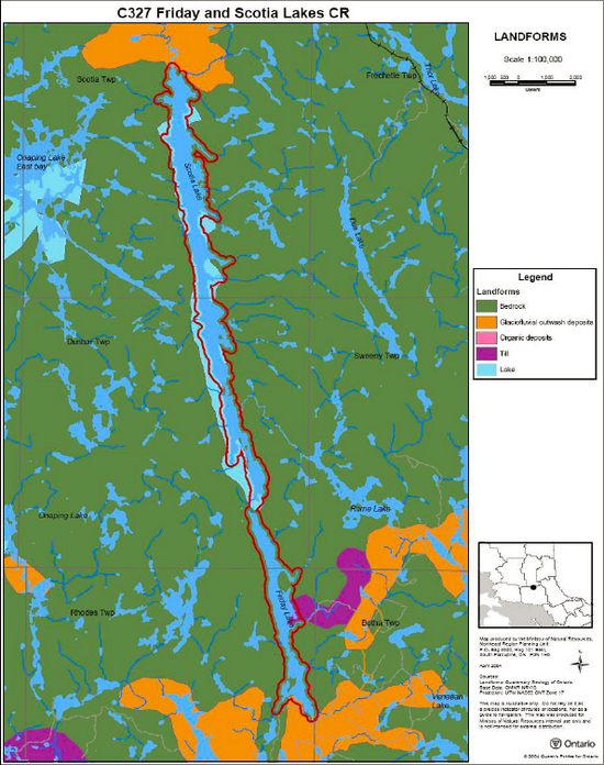
Enlarge map 2: Landforms in Friday and Scotia Lakes Conservation Reserve
Map 3: Forest Communities within Friday and Scotia Lakes Conservation Reserve
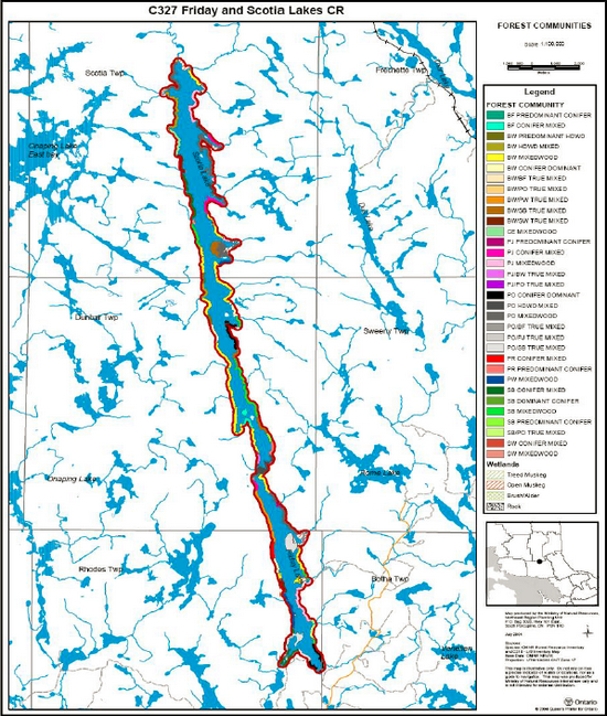
Enlarge map 3: Forest Communities within Friday and Scotia Lakes Conservation Reserve
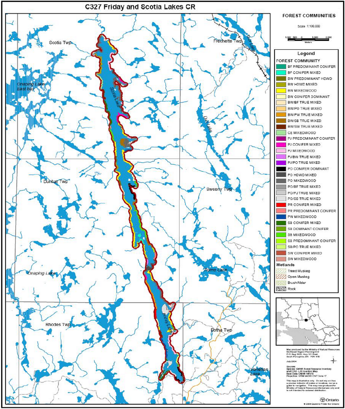
Map 4: Wetland Communities within Friday and Scotia Lakes Conservation Reserve
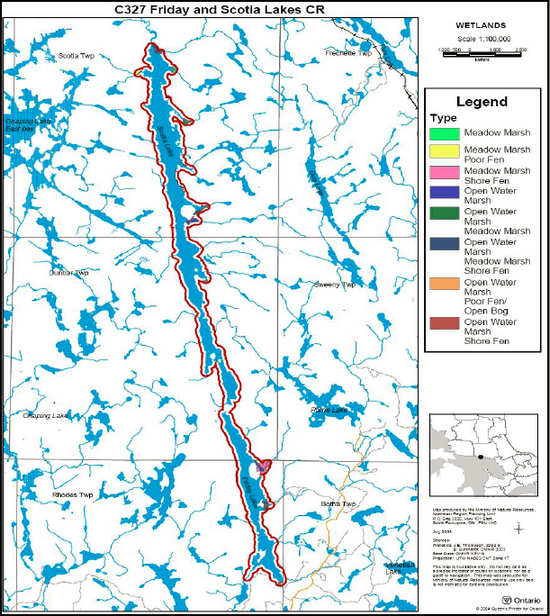
Enlarge map 4: Wetland Communities within Friday and Scotia Lakes Conservation Reserve
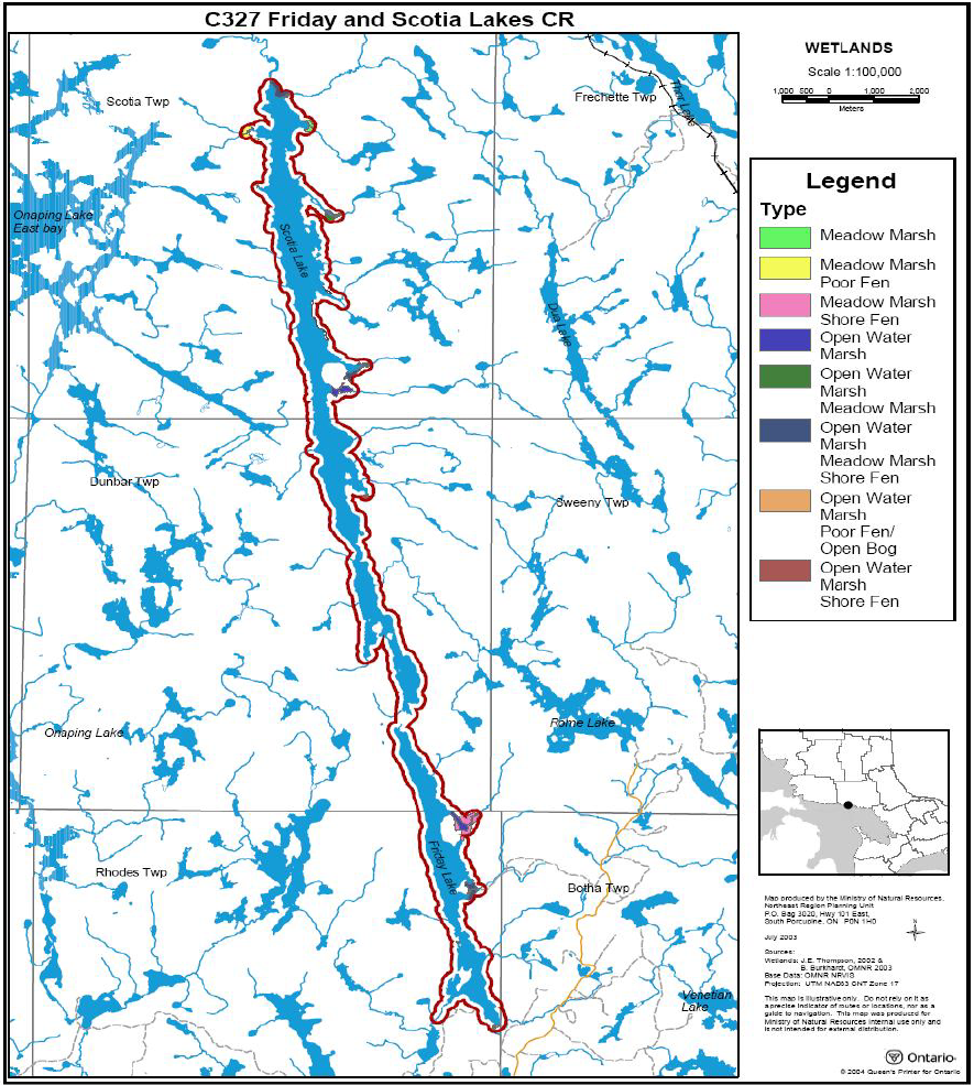
Appendix B: Friday and Scotia Lakes Conservation Reserve Photos
Appendix C: Amendments to the SCI
Photo 1: Island in the middle of Scotia Lake, facing northwest. A mix of white pine, white birch and black spruce, not captured in the FRI data. Boulder and cobble shoreline. Photo by B. Burkhardt, August 27/03
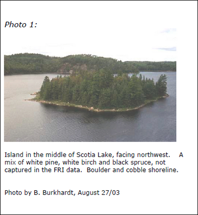
Photo 2: Scotia Lake, as seen from the south end. A mix of cobble, boulder & bedrock outcrop shorelines. Poplar and white birch declining and/or affected by tent caterpillar infestation. Photo by B. Burkhardt, August 27/03
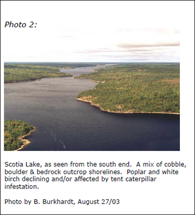
Photo 3: Friday Lake, as taken from the south end. Cobble shoreline with some bedrock. Dominant forest communities include poplar, black spruce, jack pine and white pine. Photo by B. Burkhardt, August 27/03
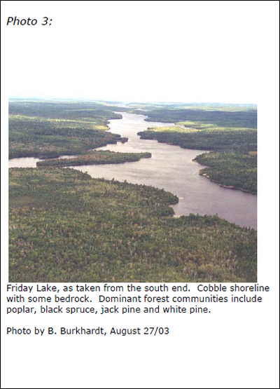
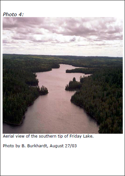
Photo 4: Aerial view of the southern tip of Friday Lake. Photo by B. Burkhardt, August 27/03
Footnotes
- footnote[1] Back to paragraph Ecodistricts are areas characterized by physiographic (landform) similarities, and by the successional trends exhibited by the predominant vegetation types on those physiographic features, see section 5.0 - State of the Resource (Hills 1959; Crins and Uhlig 2000).
- footnote[2] Back to paragraph Disturbance rating is based on the amount of conservation reserve area currently under some form of known disturbance: >20%, high; 10-20%, medium; <10%, small (Cudmore and Longyear 2004).
- footnote[3] Back to paragraph Diversity rating is based on the size of the protected area versus the number of landforms: vegetation (SFU/HU) combinations. For conservation reserves <500 ha in size, >25 L:V combinations is considered to have high diversity, >15 L:V combinations is considered to have medium diversity, and <15 L:V combinations is considered to have low diversity. For areas 500 – 2000 ha, diversity is rated as high if there are >30 L:V combinations, medium if there are >20 L:V combinations and low if there are < 20 L:V combinations (Thompson and Noordhof 2003)