Galbraith Peatland Conservation Reserve Management Statement
This document provides policy direction for the protection, development and management of the Galbraith Peatland Conservation Reserve and its resources.
Statement of Conservation Interest
Ministry of Natural Resources
Sault Ste. Marie District
Northshore Area
January 30, 2004
Ontario
Ce document est seulement disponsible en anglais.
Approval Statement
I am pleased to approve this Statement of Conservation Interest (SCI) for Galbraith Peatland Conservation Reserve (C266).
Galbraith Peatland Conservation Reserve protects provincially significant deep organic deposits found in a wetland complex of swamps, bogs and fens. The site is also historically unique. From the mid-1970s to the mid-1990s peat was extracted by the Ministry of Natural Resources for horticultural use at the Kirkwood Tree Nursery near Thessalon. Regulated on December 7, 2002, this 121 hectare conservation reserve is situated approximately 50 kilometres east of the City of Sault Ste. Marie, in Galbraith Township.
Direction for establishing, planning and managing conservation reserves is defined under the Public Lands Act, the Ontario’s Living Legacy Land Use Strategy and other applicable policies. The specific direction for managing this conservation reserve is in the form of a basic SCI, which defines the area to which the plan applies, provides the purpose for which the conservation reserve has been proposed, and outlines the Ministry of Natural Resources' management intent for the protected area. This SCI has been created with input from program specialists within Sault Ste. Marie District. It will provide both the foundation for the continued monitoring of activities and guidance for the management of the conservation reserve. More detailed direction at this time is not anticipated. However, should significant facility development be considered or complex issues arise requiring additional studies, more detailed management direction in the form of special protection measures, or a detailed Resource Management Plan, will be prepared with full public consultation.
Public and Aboriginal consultation occurred prior to the regulation of this conservation reserve. An additional 15-day consultation period took place in December, 2003 that provided stakeholders with an opportunity to comment on the draft SCI. Comments from the review period have been considered in the development of this document.
The management guidelines outlined in this SCI will be implemented by the Northshore Area Supervisor, and will be reviewed every five years and amended as required by the District Planner, Sault Ste. Marie District, Ministry of Natural Resources.
Written by:
Joey Young, OLL Intern
Date: January 30, 2004
Submitted by:
Erin Nixon, District Planner
Date: January 30, 2004
Recommended for approval by:
Dick Hagman
Northshore Area Supervisor
Date: February 11, 2004
Serge Tenaglia R.P.F.
District Manager, Sault Ste. Marie District
Date: February 19, 2004
Approved by:
Rob Galloway
Regional Director, Northeast Region
Date: April 02, 2004
1.0 Introduction
The following document is a Statement of Conservation Interest (SCI) for Galbraith Peatland Conservation Reserve (C266). The purpose of this SCI is to identify and describe the natural, recreational, and cultural values of Galbraith Peatland Conservation Reserve and to outline the Ministry of Natural Resources' management intent for this area. The first three sections of this document highlight the provincial context in which it was produced, state its goal and objectives, and summarize the planning process for conservation reserves. Sections 4 through 7 are specific to Galbraith Peatland Conservation Reserve and provide background information and management direction for the site. Section 8 outlines the requirements for continued implementation and review of this document.
Management direction specified in this SCI will serve to protect the conservation reserve for the benefit of all Ontario residents. This direction will comply with the land use intent stated in the Ontario’s Living Legacy Land Use Strategy (LUS) (OMNR 1999) and associated policy clarification statements. Additionally, this conservation reserve will be managed under the Public Lands Act (OMNR 1997a), and will comply with all legal requirements as specified under the Environmental Assessment Act (R.S.O. 1990, Chapter E.18).
1.1 Provincial context
Ontario’s network of natural heritage areas has been established to protect and conserve areas representative of the diversity of the natural regions of the province, including the species, habitats, features, and ecological systems which comprise that natural diversity. Protected natural heritage areas are a key component in the sustainable management of natural resources. They ensure that representative sites within the larger managed landscape are retained in as natural a state as possible.
On July 16, 1999, the Land Use Strategy (LUS) (OMNR 1999) was released to guide the planning and management of much of Ontario’s Crown lands. Extensive consultation was conducted during the development of the Land Use Strategy. The objectives of the Land Use Strategy are to complete Ontario’s system of parks and protected areas; recognize the land use needs of the resource-based tourism industry; provide forestry, mining and other resource industries with greater certainty around land and resource use; and, enhance hunting, angling and other Crown land recreational opportunities.
The LUS (OMNR 1999) contributes to completing Ontario’s system of protected natural heritage areas by designating 378 new areas to be protected. These areas are considered to be significant and require protection from incompatible activities in order for their values to endure over time. Galbraith Peatland Conservation Reserve was created during this expansion and now forms part of Ontario’s network of natural heritage areas. The site was selected to protect a wetland complex of swamps, bogs and fens. These deep organic deposits are located on an ancient lake bottom and are designated as provincially significant. Another special feature of the site is its history. From the mid-1970s to the mid-1990s, peat was extracted by the Ministry of Natural Resources (MNR) for horticultural use at the Kirkwood Tree Nursery near Thessalon. Evidence of this historic operation is still visible when visiting the site.
The Ministry of Natural Resources has established conservation reserves as a tool to protect natural heritage areas on public lands, while permitting most traditional public land uses to continue. These uses include recreational activities, such as hunting and fishing, and the traditional activities of Aboriginal communities, as defined under applicable Aboriginal treaties. Lands designated as conservation reserves in the LUS (OMNR 1999) are removed from the Sustainable Forest License area, and mining and surface rights are withdrawn from staking under the Mining Act (RSO 1990 Chapter M.14).
The LUS (OMNR 1999) and subsequent policy clarification statements outline the general land use policy and management direction for new conservation reserves. Each new conservation reserve will have a planning document, either a SCI or, in more complex situations, a Resource Management Plan, that details site-specific management direction.
2.0 Goal and objectives of the SCI
2.1 Goal
The goal of this SCI is to provide the framework and the direction to guide management decisions affecting Galbraith Peatland Conservation Reserve.
2.2 Objectives
The following objectives are identified as the means to achieve the above stated goal:
- To describe the site’s current state of the resource in terms of its values and existing uses and activities.
- To outline the Ministry of Natural Resources' management intent for the protected area.
- To determine the land use compatibility of current land uses, and to develop specific guidelines and prescriptions to manage these uses.
- To create public awareness of the values within this conservation reserve by providing information on the resources it contains and protects, and to support responsible stewardship through partnerships with local stakeholders.
- To identify research, client services, and/or marketing strategies that may contribute to sound long-term management of the conservation reserve.
- To identify the monitoring and/or research necessary to maintain the integrity of protected values.
- To provide direction for the evaluation of proposed new uses or economic ventures through the application of the Test of Compatibility (Appendix C) and applicable Environmental Assessment Act legislation. This test will evaluate the impact of suggested use(s), either positive or negative, on the protected values of the conservation reserve.
3.0 Management planning
3.1 Planning for a conservation reserve
The planning process for a conservation reserve consists of regulating the site and preparing a site specific management plan. Consultation with the public, aboriginal communities, and industry occur during site identification, boundary finalization, and management planning. Regulation of a conservation reserve involves preparing a legal description of site boundaries, removing the site from the Sustainable Forest Licence area, and withdrawing the site from staking under the Mining Act (RSO 1990 Chapter M.14). Once a conservation reserve is regulated, the level of management planning required to fulfill the protection targets is determined, and either a basic or enhanced SCI or a Resource Management Plan is prepared.
A basic SCI is prepared when there is no deviation from the land use direction provided in the LUS (OMNR 1999) and there are few to no issues that require resolution. Alternatively, a Resource Management Plan (RMP) is prepared in situations where one or more complex issues have to be addressed, and/or where there is widespread public interest in a site. An enhanced SCI is an intermediary document which is used when a site requires more detailed management direction than would be provided by a basic SCI, but does not have issues significant enough to warrant the preparation of a RMP. Whichever the determination, the plan must be completed within three years of the conservation reserve’s regulation date. The guidelines for the preparation of these documents are provided in Procedural Guidelines A - Resource Management Planning (Conservation Reserves Procedure PL3.03.05, Public Lands Act) and the Northeastern Region Guidelines on the Planning Process for Conservation Reserves: Statement of Conservation Interest and Resource Management Plan (Thompson 2001).
A SCI is essentially a management plan, which receives its direction from the LUS (OMNR 1999) and associated policy clarification statements. The purpose of a SCI is to identify the state of the resource in terms of the site’s values and its current land use activities, and to outline the Ministry of Natural Resources' management intent for the conservation reserve. Basic SCIs typically have a 15-day public consultation period, whereas enhanced SCIs and RMPs have a longer consultation period. Upon completion of this public review, the SCI, or RMP, is revised as necessary and approved by the appropriate Regional Director.
Existing permitted uses within conservation reserves may continue, unless they are shown to have a significant negative impact on the values protected by the site. A review/evaluation mechanism is in place to address new permitted uses or land use proposals. The Test of Compatibility (Appendix C) as outlined in the Public Lands Act Policy PL 3.03.05 (OMNR 1997a), and/or other standard Ministry of Natural Resources' environmental screening processes, are used to screen future proposals. Where cultural resources may be impacted, proposals may be screened through Conserving a Future for our Past: Archaeology, Land Use Planning & Development in Ontario, Section 3 (MCzCR 1997).
Public comment may be solicited during a review of any future land use proposals that require new decisions to be made. Appropriate Environmental Assessment Act (R.S.O. 1990, Chapter E.18) requirements and amendment processes will apply to any future proposal and/or any significant change in management direction being considered for a site.
3.2 Planning process for Galbraith Peatland Conservation Reserve
Galbraith Peatland Conservation Reserve was proposed as a conservation reserve in the LUS (OMNR 1999). Consultation has occurred with the public, aboriginal communities, and industry, and the boundary of the site has been regulated through an amendment to Ontario Regulation 805/94 of the Public Lands Act on December 7, 2002, by Ontario Regulation 313/02. A copy of public consultation documents can be found in Appendix E.
To date, no significant issues related to land use in this area have been identified. For this reason, it was determined that a basic SCI will adequately identify the site’s significant features and serve as the appropriate format for providing the management guidelines. It should be noted that this document addresses only those issues or land use proposals currently known to the District Manager. The direction provided by this SCI, and future management decisions, will work to resolve any potential land use conflicts and to ensure that identified values continue to be adequately protected.
3.2.1 Planning area
The planning area for this SCI consists solely of the regulated boundary for Galbraith Peatland Conservation Reserve (see Appendix A, Map 1). However, to fully protect values within the conservation reserve, the area beyond the regulated boundary may require additional consideration through land owner outreach programs when adjacent land uses pose potential negative impacts on the conservation reserve. Crown land areas beyond the regulated boundary may also require additional consideration when larger land use planning initiatives, such as forest management planning, pose potential negative impacts on the site. Section 7.1 discusses management implications with areas outside the regulated boundary.
4.0 Background information
4.1 Location and site description
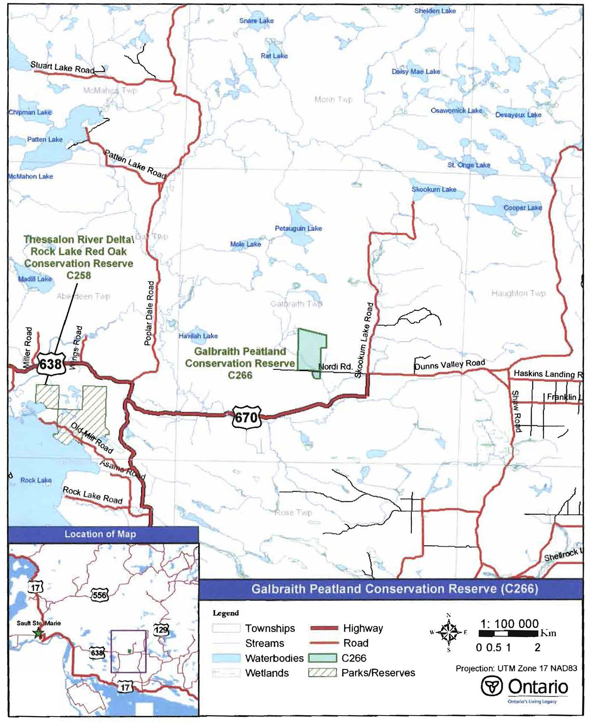
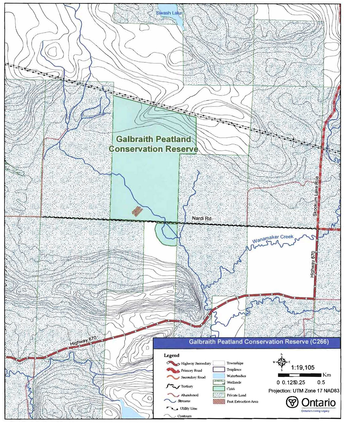
Galbraith Peatland Conservation Reserve is located approximately 50 km east of the City of Sault Ste. Marie and 20 km north of the Town of Bruce Mines, in Galbraith Township (see Figure 1). This site was regulated on December 7, 2002 and is 121hectares in size. Table 1 summarizes the administrative details of the site.
Whenever possible, recognizable natural and cultural features, such as creeks, shorelines or old roads have been used to delineate conservation reserve boundaries to facilitate on-the ground identification (see Map 1, Appendix A). Galbraith Peatland Conservation Reserve is divided into two portions, which are separated by a tertiary access road (Nardi Road). The east-west boundary of the northern, larger portion of the site follows the lot lines of patented, private lands. Cultural features, consisting of Nardi Road and a transmission line, form the southern and northern boundaries respectively (encompassing most of Lot 7, Concession 3). The southern, smaller portion of the site uses a setback from Nardi Road to form the northern boundary and patented lands to form the eastern boundary. The west boundary of the south portion consists of an 80 m buffer from the creek’s edge.
Galbraith Peatland Conservation Reserve is a fairly accessible site. The conservation reserve can be found by traveling north from Bruce Mines via Highway 638(South) or east from Echo Bay via Highway 638(West) to Highway 670. At the end of Highway 670, turn left onto Nardi Road (see Map 1, Appendix A).
Figure 1: Site Location for Galbraith Peat/and Conservation Reserve.

Enlarge Figure 1: Site Location for Galbraith Peat/and Conservation Reserve.
The main access into the site is located off of Nardi Road at the entrance to the old peat extraction site. Since Nardi Road is a tertiary, gravel road, its condition may change throughout the year. As illustrated in Appendix B, Photo 1, there is permanent drainage into the ditches on the north and south sides of Nardi Road and flooding of the road can occur during the spring and fall. Furthermore, the bog/fen complex is very wet. The peat layer has a depth of up to 6 m and is highly unstable.
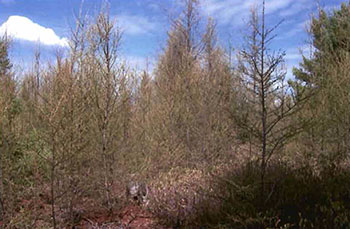
Galbraith Peatland is located within Site District1 SE-1(Hills 1959), an ecological unit extending along the St. Mary’s River and North Channel of Lake Huron, roughly from Gras Cap on Lake Superior eastward to the Spanish River. The conservation reserve is a provincially significant wetland complex of swamps, bogs and fens. The site also features previous peat extraction lines and drainage ditches, as well as a bedrock ridge that rises quickly from the black spruce (Picea mariana [P. Mill.] B.S.P.) bog areas. Black spruce and tamarack (Larix Iareina [Du Roi] K. Koch) are the major coniferous species, and dominate the treed bog and treed fen areas (Burkhardt et al. 2003). Poplar (Populus sp.) and sugar maple (Acer saccharrum Marsh.) stands are associated with the bedrock ridge on the north side of the site.
An unnamed creek flows through the southern section of the site into Wanamaker Creek. Ditches were created adjacent to the creek in 1982 for the drainage of the extraction area and are still visible today (see Figures 2 and 5). Other photos of the conservation reserve can be found in Appendix B.
Table 1: Administrative details for Galbraith Peatland Conservatton Reserve.
| Name | Galbraith Peatland Conservation Reserve (C266) |
|---|---|
| Site Region - Site District (Hills 1959) | 5E-1 Thessalon |
| Ecoregion - Ecodistrict (Crins and Uhlig 2000) | 5E-1 |
| OMNR Administrative Region/District/Area | Northeast Region/Sault Ste. Marie District/Northshore Area |
| UTM co-ordinates | Zone 17 (NAD 83) 296250 E, 5149600 N |
| SCI Completed | January 30,2004 |
| Regulated | December 7, 2002 |
| Area | 121 ha |
| Nearest Town | Approximately 50 km east of the City of Sault Ste. Marie; approximately 22 km north of the Town of Bruce Mines |
| Township | Galbraith |
| OBM Numbers | 20172900S1500, 2017290051400 |
| Topographical Map Number/ Name | 41 J 5 Bruce Mines |
| Wildlife Management Unit | 36 |
| Forest Management Unit | Northshore Forest |
4.2 History of the site
According to Ministry of Natural Resources' records, during the winter of 1974/75, 1,800 cubic metres (1,200 tons) of peat were extracted from the site for horticultural use at the Kirkwood Tree Nursery near the Town of Thessalon. In 1975, the bogs and fens of Galbraith Peatland Conservation Reserve were identified as an abundant source of peat. Plans in 1977 to supply the growing nursery and other northeast regional Ministry of Natural Resources' interests required an increase in extraction to 2,300 cubic metres (1,500 tons) of peat.
Due to the rising demand for peat and other alternative fuel sources (as a result of the first global oil crisis in the mid-1970s), many studies and surveys were conducted during the early 1980s to examine the quantity, quality and commercial potential of the peat resources in Ontario. Areas of fuel-grade peat and horticultural-grade peat2 were identified within Galbraith Peatland. During this time, the Ministry of Natural Resources and the Ministry of Energy were also evaluating the potential of using the peat as a fuel source in multi-fuel boilers. The quantity of the resource was estimated to be between 360,000-450,000 m3 (235,000-294,000 tons) and the energy equivalent to be approximately 325,000-405,000 megawatt hours (OMNR 1981). In terms of an average home in 1980, requiring 7.4 tons of peat annually (Monenco Ontario Limited 1981), the fuel resource within the peatland would be enough to heat one thousand homes for over 35 years.
In 1982, peripheral drainage ditches were started along the unnamed creek to divert water from the harvesting areas to allow for increased extraction (see Figure 2). The bog, however, was only partially drained and the cost of completing the ditches was estimated at $250,000. The Ministry of Natural Resources continued to extract the peat resource every 2-3 years up to the mid-1990s, when the closure of the Kirkwood Tree Nursery halted all extraction. A series of air photos in Figure 4 illustrate the progression of extraction at the site from 1974 to 2000.
Figure 2: Aerial view of ditch construction in 1982.
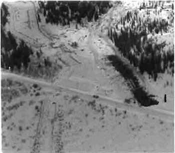
The costs associated with completing the drainage ditches and conducting an extensive Figure 2: Aerial view of ditch construction in 1982. Environmental Assessment made any further government development of the site unfeasible. However, private commercial businesses continued to show some interest in peat extraction into the late 1990s. In the 1999 LUS, the bog was identified as a recommended conservation reserve.
4.3 Inventories
Table 2 indicates the current status of natural heritage inventories that have occurred for Galbraith Peatland Conservation Reserve. Recommendations for future inventory needs are located in Table 3, Section 7.2.
Table 2: Inventory and Survey Information for Galbraith Peatland Conservation Reserve.
| Type of Inventory | Inventory Method | Date(s) of Inventory | Report |
|---|---|---|---|
| Life Science | Aerial reconnaissance | 9 Sept. 2002 | Burkhardt, B., Longyear 5., & King, L. 2003. Galbraith Peatland Conservation Reserve, Natural Heritage Area: Life Science Checksheet. Unpublished Information. Ontario Ministry of Natural Resources (in prep.) |
| Earth Science | Aerial reconnaissance | 9 Sept. 2002 | Kristjansson, F.J. 2003. Earth Science Checksheet for Galbraith Peatland Conservation Reserve. Unpublished Information. Ontario Ministry of Natural Resources (in prep.). |
| Recreation | Ground and aerial reconnaissance | Ground: 15 Aug. 2002 15 May 2003 7 Oct. 2003 Air: 9 Sept. 2002 | Latulippe, T. & Hall, M. 2003. Recreation Checksheet for Galbraith Peatland Conservation Reserve. Unpublished Information. Ontario Ministry of Natural Resources. |
5.0 State of the resource
5.1 Key values
Key values are those values that make this site unique and have led to its designation as a conservation reserve. Their protection is paramount. The key values found within Galbraith Peatland Conservation Reserve include the following:
- A provincially significant wetland complex of swamps, bogs, and fens located on a weakly broken lacustrine plain.
- Sugar maple trees located on moderately broken shallow sandy till uplands.
- The unique history of the site, as the area was an important peat deposit for extraction by the Ministry of Natural Resources from the mid-1970s to the mid-1990s.
Additional values as listed in Section 5.2 through Section 5.6 are also important. Descriptions in this section are not necessarily complete. If new values, key or otherwise, are identified, they will be added to this section. If any new value is considered significant, management guidelines may be modified, if required, to ensure its protection.
5.2 Earth science values
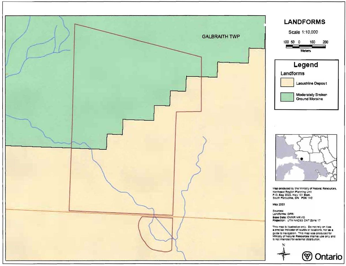
Galbraith Peatland Conservation Reserve is situated in a rolling landscape. The conservation reserve is found within ecological Site District 5E-1, which is characterized by two major physiographic landforms (Noble 1993). The first landform type consists of weakly broken terraced lacustrine clay, silt and sand plains broken by bedrock. The second type is comprised mostly of broken bedrock-controlled, till-covered uplands backing lacustrine flatlands (Noble 1993). Both of these landform types are evident within the conservation reserve (see Map 2, Appendix A).
Within the conservation reserve, the surficial geology varies from moderately broken ground moraine in the northwest to lacustrine deposits in the southeast (Kristjansson 2003). The ridge in the northern section of the site is classified by Noble (1993) as being moderately broken shallow sandy till uplands (bedrock). Also, Noble (1993) classified the wetland portions of the site as being comprised of a weakly broken lacustrine silt and clay plain (organic). During an aerial reconnaissance survey of the site, Kristjansson (2003) verified Noble’s classifications and also identified an underlying bedrock-drift complex in the northcentral/northeast section of the site, the surface of the bedrock-drift complex being in a bedrock ridge or bedrock knob form.
According to Ministry of Natural Resources' records and a study of the area by Graham (1979), the organic deposits are located over a light grey-blue to grey clay formation, are up to 6 m in depth, and cover an area approximately 85 ha in size.
5.3 Life science values
Galbraith Peatland Conservation Reserve is located in the Algoma section of the Great Lakes St. Lawrence Forest Region (Rowe 1972), in ecological Site District 5E-1 (Hills 1959). This region is typified by a mid-humid, warm-boreal climate and supports a variety of tree communities, ranging from softwoods in the cool valleys to hardwoods associated with higher altitudes. Drainage in this site district is generally to the west and southwest through preglacial valleys, some of which have been filled with deep glacial-fluvial material (Burkhardt et al. 2003).
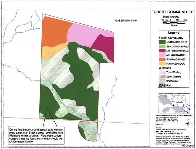
The main forest community within the conservation reserve is black spruce dominant stands (Burkhardt et al. 2003), which are prevalent through the central area of the conservation reserve. Mixedwood stands of poplar and sugar maple are limited to the upland areas of the northern section of the site (see Map 3, Appendix A). No possible old growth stands are evident within the conservation reserve. Most of the forest stands in the site are between 60 to 89 years old, with 61 to 80% stocking 3 of the hardwood communities and less than 60% stocking of the black spruce communities (Burkhardt et al. 2003).
A small unnamed creek, whose headwaters are immediately northwest of the site, drains through the southwest portion of the conservation reserve into Wanamaker Creek, as part of a tertiary watershed of the Lake Huron Basin.
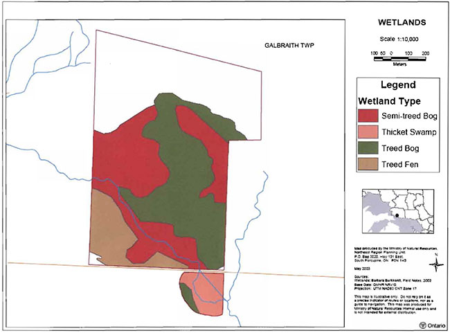
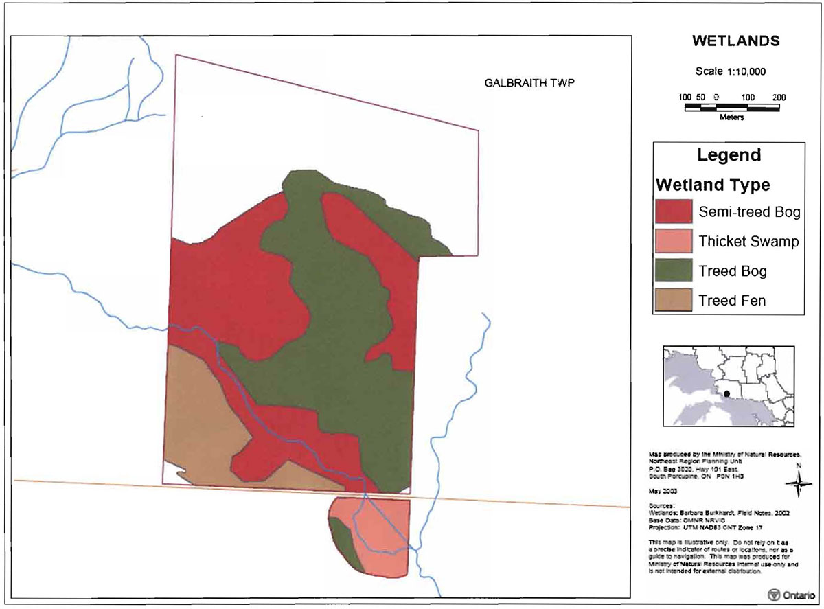
Additionally, more than 30% of the conservation reserve is classified as wetland area (Burkhard et al. 2003). The wetland communities (Map 4, Appendix A) are comprised of tree, shrub and herb species that include black spruce, tamarack, eastern white cedar (Thuja occidentalis L.) sphagnum moss (Sphagnum <abbr title="multiple species">spp.</abbr>), labrador tea (Ledum groenlandicum Oeder), leatherleaf (Chamaedaphne calyculata [L.] Moench), wild sarsaparilla (Aralia nudicaulis L.) and goldthread (Coptis trifolia [L.] Salisb.) (Bergsma 1998). Appendix B, Photo 6 is a typical snapshot of the wetland area in the southwestern section of the conservation reserve. A detailed analysis of the wetlands within the conservation reserve is required to determine the site’s biotic significance. Furthermore, there is currently no information on aquatic species in the site.
Sandhill cranes (Grus canadensis) were observed during the aerial reconnaissance survey of the site in 2002 (Burkhardt et al. 2003). Also, black bears (Ursus americanus) potentially use this site due to the large quantity of blueberries (Vaccinium sp.) available during the summer months (Burkhardt et al. 2003).
5.4 Recreational values
Although the conservation reserve is easily accessible, the small size of the site and its wetland landscape limits its recreational uses. As indicated by Burkhardt et al. (2003), only low intensity recreational activities such as berry picking, bird watching and small-game hunting are thought to occur. Please refer to Section 4.1 for information on access.
Recreational users of the site should be aware of the potentially hazardous conditions of the extraction areas, due to the depth and instability of the peat. Photo 2, Appendix B, shows the warning sign located at the former entrance, which also indicates that previous peat mining took place on the site.
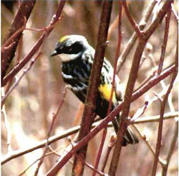
Waterfowl hunting and bird watching are the two main activities occurring in the conservation reserve. Yellow-rumped warblers (Dendroica coronata, see Figure 3), yellow warblers (Dendroica petechia) and American redstarts (Setophaga ruticilla) are examples of probable breeding birds found at the site. Other activities that exist or have potential within Galbraith Peatland are blueberry picking and nature studying.
5.5 Cultural values
This site falls within the Robinson-Huron Treaty area. To date, no First Nation community has identified any specific Aboriginal values within this conservation reserve.
Figure 3: Yellow-rumped warbler in alder thicket.
(J.Young, May 15, 2003. OMNR)
5.6 Research values
Conducted in the late 1970s and early 1980s, an evaluation of the type and quantity of peat within the Galbraith Peatland is the only known on-site research activity to have occurred. Concurrently, the Ministry of Natural Resources and Ministry of Energy were evaluating the potential of using fuel grade peat as an alternative fuel source in multi-fuel boilers. Recommendations to study the economic viability and environmental impacts were addressed, by way of monitoring the performance and assessing the impacts of peat as the primary fuel resource at the Kirkwood Nursery (Middleton Associates 1982).
5.7 Site condition
Interpretation of aerial photographs and visits to the site indicate that disturbance is high within Galbraith Peatland Conservation Reserve north of the Nardi Road. The major disturbances are the visible trench lines, the peripheral drainage ditches, and the drainage channel which are all associated with past peat extraction activities. Figure 4 illustrates the progression of the extraction trenches.
Figure 4: Aerial photos (from left to right: 1973, 1981, 1986, 1997 and 2000) showing the progression of drainage ditch construction and peat extraction.
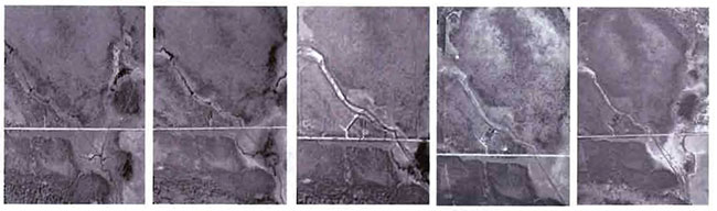
A wire fence and danger sign were erected at the entrance to discourage entry and use of the site. All old roads that were used for the Ministry of Natural Resources' operations within the site have since been abandoned. Vegetation on the roads has naturally regenerated, primarily in the form of alder thickets. However, due to the sensitivity and slow growing nature of the wetlands, much of the disturbance will be evident for many more years (as illustrated by the peripheral ditches in Figure 5). The areas most highly impacted by extraction activities will probably not return to their natural state, unless active rehabilitation is undertaken.
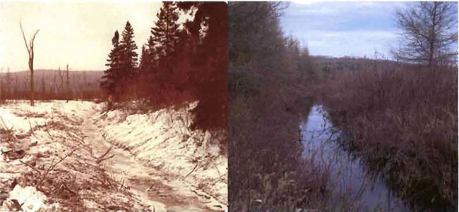
Figure 5: Photos of peripheral ditching along creek in 1982 (left) and 2003 (right).
(Photo by Ministry of Natural Resources. 1982) (Photo by Marjorie Hall, Ministry Natural Resources. 2003)
6.0 Management guidelines
All management guidelines in this SCI are based on direction contained in the LUS (OMNR 1999) and associated policy clarification statements. The management guidelines outlined in this section are specific to Galbraith Peatland Conservation Reserve and are intended to protect the site’s unique values. The guidelines in this document may be subject to change and may be amended as necessary. If a conflict between management guidelines exists, the conservation reserve will be managed to protect the integrity of its natural values, while permitting compatible land use activities (Public Lands Act, PL 3.03.05).
Proposed new uses and/or development, as well as research and education activities, will be reviewed on a case-by-case basis. Before new proposals can be permitted, the Test of Compatibility (Appendix C) must be passed as well as consideration of cultural values according to Conserving a Future for our Past: Archaeology, Land Use Planning & Development in Ontario, Section 3 (MCzCR 1997). In addition, all new proposals are subject to applicable Environmental Assessment Act (R.S.O. 1990, Chapter E.18) requirements.
The following management strategies have been devised to achieve the goal and objectives of the SCI for Galbraith Peatland Conservation Reserve. A summary table of the management guidelines for this site can be found in Appendix D. For the most up-to-date version of this policy report, please refer to the Crown Land Use Atlas on the Internet at http://crownlanduseatlas.mnr.gov.on.ca, or contact your local Ministry of Natural Resources office. The Crown Land Use Atlas is a consolidation of existing local land use policies for Crown lands within the OLL planning area, an area that covers 45 percent of the province and that extends from Lake Simcoe in the south to the Albany River in the north.
6.1 Industrial activities
6.1.1 Commercial timber harvest
The area contained within this conservation reserve (121 ha) has been withdrawn from the Northshore Sustainable Forest License area and no commercial timber harvesting will be permitted. Please refer to Section 6.4.3 for information regarding non-commercial wood harvesting.
6.1.2 Mining and exploration
There are no existing mining claims or leases within this conservation reserve. Mining and surface rights within the conservation reserve’s boundaries have been withdrawn from staking under the Mining Act (RSO 1990 Chapter M.14). Mineral exploration is not permitted.
6.1.3 Extraction of peat, soil, aggregate and other material
Extraction of peat, soil, aggregate and other material is not permitted.
6.1.4 Energy generation
Hydropower development and windpower generation are not permitted.
6.2 Existing and proposed development
6.2.1 Transportation corridors
6.2.1.1 Roads
According to the LUS (OMNR 1999}, new roads for resource extraction will not be permitted except for those identified in Forest Management Plans prior to March 31, 1999. No new or existing roads for resource extraction were identified.
6.2.1.2 Trails
Currently, no organized winter or summer trails have been identified within the conservation reserve. Old roads north of the Nardi Road that were created in support of peat extraction by the Ministry of Natural Resources have since been rehabilitated, and function only as walking trails through the southern section of the site.
Any proposed new trails are subject to the Test of Compatibility (Appendix C) and applicable Ministry of Natural Resources' policies and procedures. Trail development should take into account the unique characteristics of this site and must be compatible with the site’s key values. All existing and new trail heads and trail routes must be recorded using new technologies (i.e. global positioning systems) to ensure an accurate record of the location of the feature. This location information must be provided to the Sault Ste. Marie District, Ministry of Natural Resources.
6.2.2 Other corridor development/maintenance
No communication, energy transmission, or other non-road corridors are located within this conservation reserve. The transmission line right-of-way that forms the northern boundary of the site is excluded. New corridor developments will be actively discouraged. Proposals for new corridors will be subject to the Test of Compatibility (Appendix C) and applicable Ministry of Natural Resources' policies and procedures.
6.2.3 Natural heritage appreciation facilities/recreational structures
There are currently no existing authorized natural heritage appreciation facilities or recreational structures (i.e. boardwalks, bird viewing platforms, kiosks, ski shelters, or interpretative signs). New natural heritage appreciation facilities and recreation structures are permitted, subject to the Test of Compatibility (Appendix C) and applicable Ministry of Natural Resources' policies and procedures.
Facility development should take into account the unique characteristics of this site and must be compatible with the site’s key values
6.2.4 Land disposition
Sale of land is not permitted, except for those situations described in the policy clarification tables (OMNR 2000).
No Land Use Permits (LUPs) are currently issued within this conservation reserve. New leases or LUPs may be issued for approved public uses (i.e. not for private recreation camps), subject to the Test of Compatibility (Appendix C) and applicable Ministry of Natural Resources' policies and procedures. These leases/permits will not be sold but may be eligible for enhanced tenure or transfer.
LUPs may be renewed or transferred, subject to normal screening criteria (see list below). While these LUPs cannot be sold, enhanced tenure can be considered subject to the Test of Compatibility (Appendix C) and applicable Ministry of Natural Resources' policies and procedures.
Enhanced tenure is defined as anything beyond the term and form of current tenure. All requests for transfer or enhanced tenure will be subject to the following screening criteria:
- Is the transfer or enhanced tenure consistent with the conservation reserve’s land use intent, which is the protection and enhancement of the site’s natural, recreational and cultural values?
- Is it consistent with the land disposition policies outlined in the District Land Use Guidelines, the Crown Land Use Atlas, this SCI and any other applicable document?
- Does it adversely affect the values as identified in Section 5.0, and/or conflict with other uses?
- Is land needed by the Crown to protect significant natural or recreational values outlined in this SCI?
- Does the transfer or enhanced tenure clash with traditional Aboriginal uses, land claims or agreements?
- Are all rents, taxes, fees, rates or charges paid up for the existing LUP or lease?
6.3 Commercial activities
6.3.1 Commercial bait harvesting
Galbraith Township is currently allocated for one commercial bait harvesting operation. New operations can be considered subject to the Test of Compatibility (Appendix C) and applicable Ministry of Natural Resources' policies and procedures.
Under Public Lands Act PL 3.03.08 "Buildings for Bait Harvesting Management" (OMNR 2002), cabins for the purposes of bait harvesting may be constructed on Crown land. However, such buildings should be avoided within this conservation reserve and established on Crown land outside of the protected area.
6.3.2 Commercial fishing
There are currently no commercial fisheries. New operations may be considered subject to the Test of Compatibility (Appendix C) and applicable Ministry of Natural Resources' policies and procedures.
6.3.3 Commercial fur trapping
Registered Trapline Area BL003 encompasses the boundary of this conservation reserve. This registered trapline area is currently allocated to a head trapper. If a head trapper surrenders a registered trapline, or the head trapper’s privileges are revoked, the registered trapline may be transferred to another trapper following established allocation procedures. If the registered trapline is not transferred in due course, or remains unallocated for a significant period of time, reallocation of the trapline may occur following applicable district screening processes.
The establishment of new trapline trails will be considered following the procedure and criteria for new trails as outlined in Section 6.2.1.2. No trap cabins currently exist within Galbraith Peatland Conservation Reserve. The establishment of new trap cabins will not be permitted.
6.3.4 Bear management areas
No Bear Management Area (BMA) is associated with this conservation reserve.
Clarification on the policies regarding BMAs (OMNR 2003) states that the issuance of Licences to Provide Bear Hunting Services will be allowed where areas have been licensed or authorized under agreement for the activity since January 1, 1992. Since a BMA was still active after the above date, the area of the conservation reserve may be eligible for future operations should the land be considered for establishing a new BMA. However, due to the extensive private lands surrounding the conservation reserve, the establishment of a new BMA for this area is not being considered at this time.
6.3.5 Commercial food collection
There is currently no existing commercial food harvesting ventures. Any new ventures requiring permits from the Ministry of Natural Resources will be subject to the Test of Compatibility (Appendix C) and applicable Ministry of Natural Resources' policies and procedures.
6.3.6 Commercial non-timber forest products
Commercial harvesting of non-timber forest products is not consistent with the intent of the conservation reserve and will not be approved.
Extraction of peat is not permitted.
6.3.7 Outpost camps/main base lodges
There are currently no existing authorized outpost camps or main base lodges. New outpost camps and main base lodges may be considered through planning and will be subject to the Test of Compatibility (Appendix C) and applicable Ministry of Natural Resources' policies and procedures. The form of land tenure for these new uses will remain as a land use permit or lease. Sale of Crown land for new outpost camps or mainbase lodges will not be permitted.
6.4 Non-commercial activities
6.4.1 Nature appreciation/recreation activities
Off-trail hiking, cross-country skiing, snowshoeing, and other non-motorized activities will be permitted within this conservation reserve. However, should the impact of these activities degrade the landscape, the Ministry of Natural Resources will re-evaluate these permitted uses and decide upon a new strategy for this site. New trails to support these activities may be considered. Please refer to Section 6.2.1.2 for more details related to trail development.
Recreational users of the site should be aware of the potentially hazardous conditions of historic peat extraction areas.
6.4.2 Camping
There are no maintained campsites or campgrounds within this conservation reserve. Crown land camping policies apply, unless significant adverse effects on protected values necessitate further planning and management for this activity. Existing campsites should be used where they exist and campers should avoid sensitive areas.
6.4.3 Non-commercial consumptive resource use
Cutting of trees for non-commercial purposes may be authorized via a permit issued by the local Ministry of Natural Resources, subject to review and determination of the impact that such cutting would have on the values identified in Section 5.0. Such permits are intended only for leaseholders, Land Use Permit holders, cottagers and other property owners within the conservation reserve who do not have road access to their property and who do not have an alternate wood source outside of the conservation reserve. This permit is intended to cover fuelwood, dock stringers, and other occasional small scale uses.
Non-commercial harvesting of non-timber forest products such as berries and mushrooms can occur provided the values of the site, identified in Section 5.0, are not jeopardized. Extraction of peat is not permitted.
6.4.4 Hunting and fishing
Hunting is a traditional activity within this conservation reserve. In conjunction with current hunting regulations and conservation reserve policy, hunting is permitted to continue.
Recreational fishing is also permitted to continue in compliance with current fishing regulations.
6.4.5 ATV and snowmobile use
No authorized ATV or snowmobile trails have been identified. Please refer to Section 6.2.1.2 for more information on trails. In general, off-trail use of ATVs and snowmobiles is not permitted, due to the depth and instability of the peat as well as the sensitivity of the area. However, in some cases off-trail use is permitted for licenced trappers to access their traplines and for licenced bait harvest operators to conduct bait harvest operations. Off-trail ATV and snowmobile use are also permitted for the direct retrieval of large game by hunters. In all these cases, any formal intensive off-trail use is discouraged. Should the impact of off-trail ATV and snowmobile use degrade the landscape, the Ministry of Natural Resources will reevaluate these permitted uses and determine a new strategy.
6.5 Resource management activities
Resource management activities refer to those tools used to protect and enhance the values of this conservation reserve. Some management activities may require the use of intrusive techniques. Under normal circumstances, some of these techniques would not be permitted to occur in the conservation reserve; however, if they are found to be necessary, they may be applied under controlled conditions, to achieve a desired result. Infrastructure such as roads, trails and buildings may need to be constructed to support activities such as prescribed burns, forest regeneration, wildfire control, and insect and disease control. Activities described in this section will be deemed acceptable if the ultimate outcome is in compliance with the management intent for this conservation reserve.
6.5.1 Insect and disease control
This conservation reserve will be maintained in as natural a state as possible. Insect and disease control measures should only be considered if the identified values are significantly threatened.
6.5.2 Fire management
The Ministry of Natural Resources recognizes fire as an essential process fundamental to the ecological integrity of conservation reserves. In accordance with existing conservation reserve policy and the Forest Fire Management Strategy for Ontario, forest fire protection will be carried out as on surrounding lands.
Whenever feasible, the Ministry of Natural Resources' fire program will endeavor to use "light on the land" techniques, which do not unduly disturb the landscape, in this conservation reserve. Examples of light on the land techniques may include limiting the use of heavy equipment or limiting the number of trees felled during the fire response efforts. In cases of peat fires, however, it may be necessary to dig ditch lines down to the mineral soil in order to contain the spread of the fire.
Opportunities for prescribed burning to achieve ecological or resource management objectives may be considered. These management objectives will be developed with public consultation prior to any prescribed burning, and will be reflected in the document that provides fire management direction for this conservation reserve. Plans for any prescribed burning will be developed in accordance with the Ministry of Natural Resources Prescribed Bum Planning Manual (OMNR 1997b) and the Environmental Assessment Act (R.S.O. 1990, Chapter E.18).
6.5.3 Fish and wildlife management
New fish and wildlife management activities may be considered but will require the approval of a separate fish/wildlife management plan, which must be referenced in this SCI or an amendment made to this SCI to include specific management prescriptions. New fish and wildlife management activities are also subject to the Test of Compatibility (Appendix C) and applicable Ministry of Natural Resources' policies and procedures.
6.5.4 Vegetation management
New vegetation management activities may be considered but will require the approval of a separate vegetation management plan, which must be referenced in this SCI or an amendment made to this SCI to include specific management prescriptions. New vegetation management activities are also subject to the Test of Compatibly (Appendix C) and applicable Ministry of Natural Resources' policies and procedures.
Any new water management strategy must consider the implications on peat and wetland sustainability.
6.5.5 Forest renewal
Preference will be given to natural regeneration following any disturbance in the conservation reserve. In some cases, regeneration may be artificially assisted when it is deemed appropriate to mitigate against human disturbances (e.g. illegal occupation and trespass). Management for the conservation reserve should consider the very slow regenerative capabilities of the site.
6.6 Research
Scientific research is encouraged, by qualified individuals or institutions, that contributes to a better understanding of the natural and cultural values protected by this conservation reserve or that advances the protection, planning and management of these values. The Sault Ste. Marie District Planner should be contacted for information on research and/or monitoring opportunities within this conservation reserve. Proposals to conduct research should be directed to the Northshore Area Supervisor, Ministry of Natural Resources, Blind River Area Office, and will be subject to the Test of Compatibility (Appendix C) and applicable Ministry of Natural Resources' policies and procedures. Any site that is disturbed during research activities is to be rehabilitated as closely as possible to its original condition. Collecting may only be permitted as part of an authorized research project and may be subject to appropriate permits and conditions.
Existing Forest Resource Inventory surveys and approved resource monitoring activities are permitted to continue.
6.7 Marketing
No active marketing of this conservation reserve is anticipated.
6.8 First nations
Traditional activities and Aboriginal rights, as defined in the Robinson-Huron Treaty and other applicable legislation, will not be affected within or by the boundaries of this conservation reserve.
Any First Nation land claims within this area will be addressed according to appropriate Ministry of Natural Resources' procedures. When possible, the Ministry of Natural Resources will work with the Ontario Ministry of Culture to identify archaeological sites to be protected.
7.0 Recommendations
7.1 Additions to the reserve
Although the site is small, the boundary for Galbraith Peatland Conservation Reserve captures most of the wetland complex that was proposed for protection by Bergsma (1998). However, portions of this provincially significant peatland extend beyond the conservation reserve boundary onto adjacent private lands. As the conservation reserve is largely surrounded by private lands, the MNR should attempt to work with neighboring landowners to ensure that the values of the site are sustained.
Crown lands north of the transmission corridor should be considered for any additions to the site (see Map 1, Appendix A). The addition of these areas would further protect the featured maple trees on moderately broken shallow sandy till uplands, as well as possibly incorporate stands of hemlock (302+ years of age) that were identified by Bergsma (1998).
7.2 Future needs and considerations
The values protected by the site should be considered in land use management activities on adjacent properties to ensure sufficient protection of the site’s core values. Table 3 highlights future needs and considerations for Galbraith Peatland Conservation Reserve.
Table 3: Future Needs and Considerations for Galbraith Peat/and Conservation Reserve.
| Future Needs/ Considerations | Details |
|---|---|
| Detailed Life Science Inventory | A gap analysis of the site should be completed using provincial data sets. This analysis should be used to review the landforms/vegetation information presented in this SCI and the life science checksheet to determine more fully the site’s significance and contribution to the parks and protected areas program. A detailed evaluation of the wetlands within the conservation reserve should be completed. |
| Adjacent Property Owner Involvement | Efforts should be made to work with landowners of adjacent private lands. Specific consideration should be given to peatlands that extend both east and west of the conservation reserve. |
| Public Education | Educate the public about the key values in this site and how their activities may impact sensitive features within the conservation reserve. |
| Partnership Development | Efforts should be made to work with partners (such as the Ontario Forest Research Institute (OFRI), Sault College of Applied Arts and Technology) to gather baseline data on this site to assist with future monitoring and inspection activities. |
| Signage/Boundary Marking | Replacement of the "Danger…Do not enter" sign at the entrance to the CR should be considered. The vectored boundaries of the conservation reserve should also be marked to protect the site from adjacent land use activities. |
| Funding | Efforts should be made to obtain funding to support the above listed items, including monitoring, assessment, and inspection requirements for this site. |
7.3 Monitoring
Periodic monitoring of human activities and/or their impacts within this conservation reserve will be conducted. A schedule for cursory field monitoring will be identified within the District’s annual compliance plan and an Integrated Field Monitoring (IFM) inspection report will be filed at the Blind River Area Office. The Northshore Area Supervisor will oversee these activities. In addition, Conservation Officers will complete periodic compliance monitoring to ensure the protection mandate is maintained. If at any time human activities are deemed to be negatively impacting the protected features, the activities will be reviewed and measures taken to mitigate any disturbance.
Approved inventory, monitoring, assessment, or research activities that are compatible with protection objectives are encouraged. Any area that is disturbed during research activities is to be rehabilitated as closely as possible to its original condition. The Northshore Area Supervisor may apply additional conditions.
8.0 Implementation, review and revisions
8.1 Responsibility
The Blind River Area Team will be responsible for implementing the management policies and guidelines for Galbraith Peatland Conservation Reserve (C266). The primary role will be to provide public information and compliance monitoring to ensure adherence to current policies and guidelines.
8.2 Review and revisions
The Galbraith Peatland Conservation Reserve SCI will be reviewed every five years by the District Planner to confirm and update the information in this document.
Revisions to this document will be subject to requirements as specified in the Environmental Assessment Act (R.S.O. 1990, Chapter E.18). If changes in management direction are needed at any time, the significance of the changes will be evaluated. Minor amendments to the plan that do not alter the overall protection objectives may be considered and approved by the Area Supervisor without further public consultation. All minor amendments to the SCI will be documented in Appendix F. In assessing major amendments, the need for a more detailed Resource Management Plan (RMP) will first be considered. Where a RMP is not considered necessary or feasible, a major amendment to management direction may be considered with public consultation. Major amendments will be recommended by the District Manager and approved by the Regional Director, and will follow the appropriate guidelines (OMNR 2001).
Literature cited
Bergsma, B. 1998. Life Science Gap Analysis for Site District 5E-1. 251 pp.
Burkhardt, B., Longyear, S. and King, L. 2003. Galbraith Peatland Conservation Reserve, Natural Heritage Area - Life Science Checksheet. Unpublished information. Ontario Ministry of Natural Resources.
Crins, W.J. and Uhlig, P.W.C. 2000. Ecoregions of Ontario: Modification to Angus Hills' Site Regions and Site Districts - Revisions and Rationale.
Graham, R. B. 1979. Some Peat Moss and Peat Deposits in Selected Areas: Districts of Nippissing, Sudbury, Algoma, Thunder Bay, and Kenora; Ontario Geological Survey MDC 19, 132p.
Hills, G. A. 1959. A Ready Reference for the Description of the Land of Ontario and its Productivity. Preliminary Report. Ontario Department of Lands and Forests. Maple. Ontario.
Kristjansson, F.J. 2003. Earth Science Checksheet for Galbraith Peatland Conservation Reserve. Unpublished information. Ontario Ministry of Natural Resources.
Latulippe,T. 2002. Recreation Inventory for Galbraith Peatland Conservation Reserve. Unpublished information. Ontario Ministry of Natural Resources.
Noble, T.W. 1993. Site District 5E-1 Gap Analysis. Ontario Ministry of Natural Reources report.
Middleton Associates. 1982. Evaluation of the Use of Peat as a Source of Energy at the Kirkwood Nursery; Ontario Ministry of Natural Resources. Unpublished Document.
Monenco Ontario Limited. 1981. Evaluation of the Potential of Peat in Ontario; Ontario Ministry of Natural Resources, Occasional Paper 7. Carswell Printing Co.
Ontario Ministry of Citizenship, Culture and Recreation. 1997. Conserving a Future for Our Past: Archeology Land Use Planning and Development in Ontario, Section 3.
Ontario Ministry of Natural Resources. 1981. Peat Production Plan for the Galbraith Bog. Unpublished document. October 1981.
Ontario Ministry of Natural Resources. 1997a. Conservation Reserves. Lands and Waters Branch Policy. Public Lands Act, PL 3.03.05. Date Issued: February 11, 1997.
Ontario Ministry of Natural Resources. 1997b. Prescribed Burn Planning Manual. AFFMB Publication No. 313. Ontario Ministry of Natural Resources.
Ontario Ministry of Natural Resources. 1999. Ontario’s Living Legacy Land Use Strategy. Queen’s Printer for Ontario: Ontario, Canada.
Ontario Ministry of Natural Resources. 2000. Conservation Reserve Policy-As Amended by the Ontario Living Legacy Land Use Strategy. Unpublished document. September 2000.
Ontario Ministry of Natural Resources. 2001. Procedures for the Amendment of Ministry of Natural Resources Land Use Direction. Ontario Ministry of Natural Resources.
Ontario Ministry of Natural Resources. 2002. Buildings for Bait Harvesting Management. Public Lands Act, PL 3.03.08.
Ontario Ministry Natural Resources. 2003. Direction for Commercial Resource Use Activities in Provincial Parks and Conservation Reserves. June 2003.
Rowe, J.S. 1972. Forest regions of Canada. Dept. of Fisheries and the Environment. Canadian Forestry Service. Publication No. 1300. 172pp.
R.S.O. 1990, Chapter E.18. Environmental Assessment Act. [Accessed: September 15, 2003] http://www.e-laws.gov.on.ca/DBLaws/Statutes/English/90e18_e.htm.
R.S.O. 1990, Chapter M.14. Mining Act. [Accessed: September 15, 2003] http://www.elaws.gov.on.ca/DBLaws/Statutes/English/90m14_e.htm.
Thompson, J. 2001. Northeast Region Guidelines on the Planning Process for Conservation Reserves: Statements of Conservation Interest and Resource Management Plan. Unpublished information. Ontario Ministry of Natural Resources.
Appendix A: Galbraith Peatland Conservation Reserve Maps
Map 1: Recreational Values of Galbraith Peatland Conservation Reserve
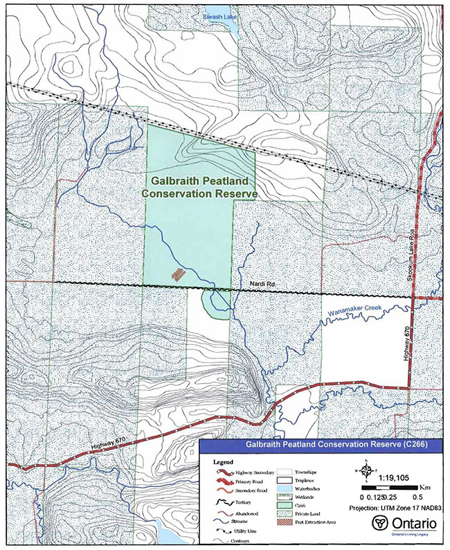
Enlarge Map 1: Recreational Values of Galbraith Peatland Conservation Reserve
Map 2: Landforms in Galbraith Peatland Conservation Reserve
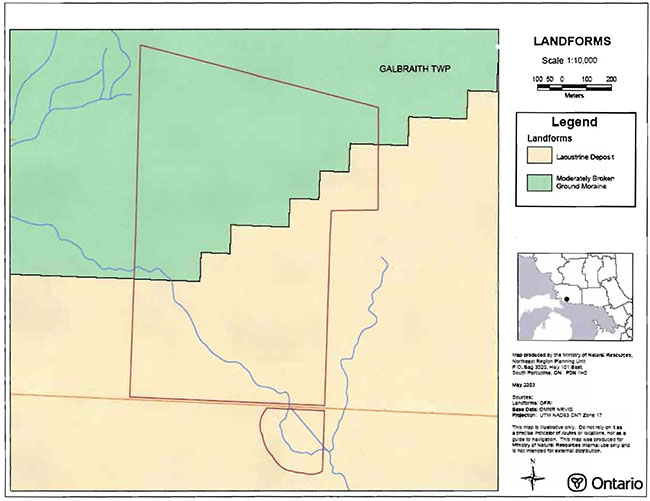
Enlarge Map 2: Landforms in Galbraith Peatland Conservation Reserve
Map 3: Forest Communities of Galbraith Peatland Conservation Reserve
Enlarge Map 3: Forest Communities of Galbraith Peatland Conservation Reserve
Map 4: Wetlands of Galbraith Peatland Conservation Reserve
Enlarge Map 4: Wetlands of Galbraith Peatland Conservation Reserve
Appendix B: Galbraith Peatland Conservation Reserve photos
Photo 1: North ditch of Nardi road from entrance.
(Photo taken by Marjorie Hall during site visit, OMNR; May 15/2003)
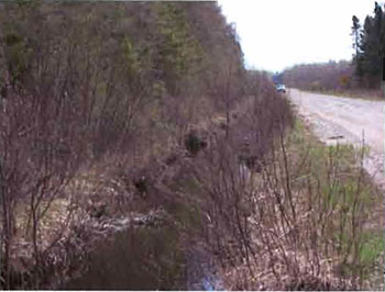
Photo 2: Peat extraction signage.
(Photo taken by Marjorie Hall during site visit, OMNR; May 15/2003)
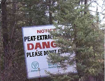
Photo 3: Southern edge of site near Nardi Road.
(Photo taken by Marjorie Hall during site visit, OMNR; May 15/2003)
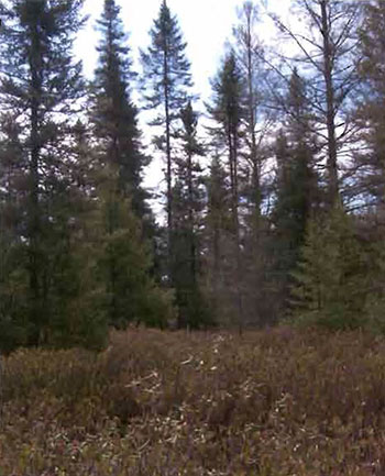
Photo 4: View looking southeast along drainage canal from bridge into southern part of C.R
(Photo taken by Marjorie Hall during site visit, OMNR; May 15/2003)
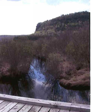
Photo 5: Extraction Trenches.
(Photo taken by Marjorie Hall during site visit, OMNR; May 15/2003)
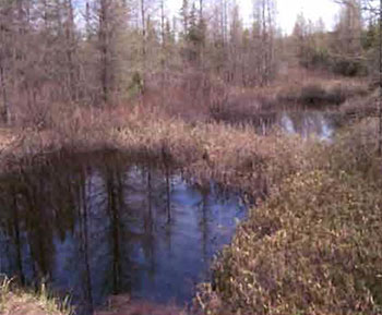
Photo 6: Typical view across southwest area.
(Photo taken by Marjorie Half during site visit, OMNR; May 15/2003)
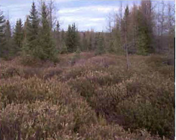
Photo 7: Budding Tamarack.
(Photo taken by Marjorie Hall during site visit, OMNR; May 15/ 2003)
Appendix C: Test of Compatibility
Test of Compatibility
The Conservation Reserve policy provides broad direction with regard to the permitted uses. The policy provides only an indication of the variety of uses that will be considered acceptable in conservation reserves. Any new uses, and commercial activities associated with them, will be considered on a case by case basis, and, subject to the following test of compatibility. To ensure a standard screening process is followed, reviews of all current and new activities will be subject to the screening criteria as specified by the Environmental Assessment Act (R.S.O. 1900, Chapter E.18).
The following outlines the two steps involved in performing a Test of Compatibility. An assessment of current activities would only follow step two, which focuses on the impacts. An assessment of any new activity would consider the impact of the activity and its conformity to the SCI/RMP.
1. Conformity to SCI/RMP: SCI describe values for which an area has been set aside and the range of appropriate uses that will be permitted in the area. SCI may also speak to the acceptability of other 'new' uses currently not occurring in the area.
The first 'test' is: "do proposed new land uses and/or commercial activities conform to the direction of the SCI/RMP for the conservation reserve? Would the new use(s) depart from the spirit of appropriate indicator land uses in the SCI/RMP?"
2. Impact Assessment: If the proposed use(s) pass test 1 it is important to determine their impact on the area before they are approved. This should include the following:
- Impact on natural heritage values: "will the new use(s) impact any natural values in the area? If so how and to what degree? Is it tolerable?"
- Impact on cultural values: "will the new use(s) impact an historical or archaeological values in the area?"
- Impact on research activities: "will the new use(s) affect research activities in the area?"
- Impact on current uses: "will the new use(s) have any negative impact on the array of current uses?"
- Impact on area administration: "will the new use(s) increase administrative costs and/or complexity?" (For example, the cost of area monitoring, security and enforcement).
- Impact on accommodating the use outside the conservation reserve: "Could the use(s) be accommodated as well or better outside the conservation reserve?"
- Impact on socio-economics of the area: "will the new use(s) affect the community(ies) surrounding the area in a positive or negative way?" (For example, will the new use make an area less remote thereby affecting a local tourism industry that is dependent on the area’s remoteness for its appeal?"
- Impact on area accessibility: "does the new use(s) give someone exclusive rights to the area or a portion of the area to the exclusion of other existing uses?"
Appendix D: summary of permitted uses
The following Policy Report was obtained from the Crown Land Use Atlas website during completion of this SCI (fall 2003). Changes may have been made to this policy report since that time. For the most recent version of this policy report, please refer to the Crown Land Use Atlas on the Internet at http://crownlanduseatlas.mnr.qov.on.ca or contact your local Ministry of Natural Resources office.
Crown Land Use Atlas- policy report
Identification:
ID: C266
Area Name: Galbraith Peatland
Area (ha): 121
Designation: Conservation Reserve (Ontario’s Living Legacy)
District(s): Sault Ste. Marie
Description:
Prehistoric lake sediments form the base of this wetland of bog and swamp habitats in Site District SE-1. Cedar, spruce, sedges and shrubs such as leatherleaf and Labrador tea dominate the wetland, which is surrounded by bedrock knolls and ridges.
Galbraith Peatland was regulated as a conservation reserve on December 7, 2002.
Land use intent:
Management of this area is also governed by the general policies contained in the Land Use Strategy (1999).
Management direction:
Those uses and management activities not listed in the following table are governed by existing conservation reserve policy. Over time the management direction will be elaborated in a Statement of Conservation Interest or Resource Management Plan. Any new uses, and commercial activities associated with conservation reserves, will be considered on a case by case basis, and they must pass a test of compatibility to be acceptable. Compatibility is normally determined through a planning process.
Commercial activities
M
| Activity | Permitted | Guidelines |
|---|---|---|
| Aggregate Extraction | No | N/A |
| Bait Fishing Existing: | Yes | Existing use permitted to continue, unless there are significant demonstrated conflicts. |
| Bait Fishing New: | Maybe | New operations can be considered, subject to the "test of compatibility" |
| Commercial Fishing Existing: | Yes | Existing use permitted to continue, unless there are significant demonstrated conflicts. |
| Commercial Fishing New: | Maybe | New operations can be considered, subject to the "test of compatibility". |
| Commercial Fur Harvesting Existing: | Yes | Existing use permitted to continue, unless there are significant demonstrated conflicts. Existing trap cabins can continue; new cabins are not permitted. |
| Commercial Fur Harvesting New: | Maybe | New operations can be considered, subject to the "test of compatibility". |
| Commercial Hydro Development | No | N/A |
| Commercial Timber Harvest | No | N/A |
| Commercial Tourism Existing: | Yes | Existing authorized facilities can continue, unless there are significant demonstrated conflicts. |
| Commercial Tourism New: | Maybe | New tourism facilities can be considered during the planning for an individual reserve. |
| Bear Hunting by Non residents (guided) Existing: | Yes | Existing authorized operations permitted to continue. |
| Bear Hunting by Non residents (guided) New: | No | New operations not permitted. |
| Outfitting Services Existing: | Yes | Existing authorized operations permitted to continue. |
| Outfitting Services New: | Maybe | New operations can be considered during the planning for an individual reserve. |
| Outfitting Services Existing: | Yes | Existing authorized operations permitted to continue. |
| Outfitting Services New: | Maybe | New operations can be considered during the planning for an individual reserve. |
| Outpost Camps Existing: | Yes | Existing authorized facilities permitted to continue. |
| Outpost Camps New: | Maybe | New facilities can be considered during the planning for an individual reserve. |
| Resorts/lodges Existing: | Yes | Existing authorized facilities permitted to continue. |
| Resorts/lodges New: | Maybe | New facilities can be considered during the planning for an individual reserve. |
| Boat Caches (Managed) Energy Transmission and Communications Corridors Existing: | Yes | These facilities should avoid conservation reserve lands wherever possible. |
| Boat Caches (Managed) Energy Transmission and Communications Corridors New: | No | N/A |
| Food Harvesting (Commercial) Existing: | Maybe | N/A |
| Food Harvesting (Commercial) New: | Maybe | N/A |
| Mineral Exploration and Development | No | N/A |
| Peat Extraction | No | N/A |
| Wild Rice Harvesting Existing: | Yes | N/A |
| Wild Rice Harvesting New: | Maybe | N/A |
Land and resource management activities
| Activity | Permitted | Guidelines |
|---|---|---|
| Crown Land Disposition Private Use: | Maybe | Sale of lands is not permitted, except for minor dispositions in support of existing uses (e.g. reconstruction of a septic system). Renewals of existing leases and land use permits are permitted. Requests for transfer of tenure will be considered in the context of the Statement of Conservation Interest or Resource Management Plan. |
| Crown Land Disposition Commercial Use: | Maybe | New leases or land use permits permitted for approved activities. Tourism facilities can apply to upgrade tenure from LUP to lease. |
| Fire Suppression | Yes | Fire suppression policies are similar to adjacent Crown lands, unless alternative fire policies have been developed through a planning process. |
| Fish Habitat Management | Maybe | N/A |
| Fish Stocking | Maybe | Existing authorized operations permitted to continue. New operations not permitted. |
| Inventory/disease Suppression | Maybe | N/A |
| Inventory/Monitoring | Maybe | N/A |
| Prescribed Burning Roads (Resource Access) Existing: | Yes | Existing roads can continue to be used. Continued use will include maintenance and may include future upgrading. |
| Prescribed Burning Roads (Resource Access) New: | Maybe | New roads for resource extraction will not be permitted, with the exception of necessary access to existing forest reserves for mineral exploration and development. |
| Vegetation Management | Maybe | Conservation Reserves policy indicates that Featured Species Management and Natural Systems Management may be permitted. Vegetation management can be considered in a planning process. |
| Wildlife Population Management | Maybe | N/A |
Science, education and heritage appreciation
| Activity | Permitted | Guidelines |
|---|---|---|
| Collecting | No | N/A |
| Historical Appreciation | Yes | N/A |
| Nature Appreciation | Yes | N/A |
| Photography and Painting | Yes | N/A |
| Research | Yes | N/A |
| Wildlife Viewing | Yes | N/A |
Recreation activities and facilities
| Activity | Permitted | Guidelines |
|---|---|---|
| All Terrain Vehicle Use On Trails: | Yes | Existing use permitted to continue where it does not adversely affect the values being protected. ATV use off trails is not permitted except for direct retrieval of game. |
| All Terrain Vehicle Use Off Trails: | No | N/A |
| Campgrounds | Maybe | N/A |
| Food Gathering | Yes | N/A |
| Horseback Riding (trail) | Yes | Existing use on trails permitted. |
| Hunting | Yes | N/A |
| Mountain Bike Use | Yes | Existing use on trails permitted. |
| Motor Boat Use Commercial: | Yes | N/A |
| Motor Boat Use Private: | Yes | N/A |
| Non-motorized Recreation Travel | Yes | N/A |
| Private Recreation Camps (Hunt Camps) Existing: | Yes | Existing camps permitted to continue, and may be eligible for enhanced tenure, but not purchase of land. |
| Private Recreation Camps (Hunt Camps) New: | No | N/A |
| Rock Climbing | Maybe | N/A |
| Snowmobiling On Trails: | Yes | Existing use permitted to continue where it does not adversely affect the values being protected. |
| Snowmobiling Off Trails: | Maybe | Snowmobile use off trails is not permitted, except that snowmobiles may be used for direct retrieval of game. |
| Sport Fishing | Yes | N/A |
| Sport Fishing Trail Development Existing: | Yes | Development of trails for a variety of activities (e.g. hiking, cross-country skiing, cycling, horseback riding, snowmobiling) can be considered as part of planning for an Individual reserve. |
| Sport Fishing Trail Development New: | Maybe | N/A |
Note: The policies outlined in this table do not supersede any Aboriginal or treaty rights that may exist,or other legal obligations.
Management of this conservation reserve is carried out within the context of Conservation Reserve policy as amended by the policies for new conservation reserves outlined in the Ontario’s Living Legacy Land Use Strategy.
Source of direction:
Ontario’s Living Legacy Land Use Strategy (1999)
Conservation Reserves Policy (1997)
Blind River District Land Use Guidelines (1983)
Appendix E: Regulation Public Consultation Material
Note that some information in these materials is no longer current- the documents are provided here as a matter of historical record.
June 1, 2001
To: Ontario Living Legacy Stakeholders
Dear Sir/Madam:
On July 16, 1999, the Ontario Government released the Ontario’s Living Legacy Land Use Strategy, a broad land use approach to the planning and management of much of the Crown lands in central and parts of northern Ontario. A major part of the Ontario’s Living Legacy Land Use Strategy was a government commitment to the biggest expansion of provincial parks and conservation reserves in Ontario’s history. Ontario intends to add 378 new areas to its protected areas system. Ontario’s Living Legacy is a momentous achievement that will be recognized around the world as a significant contribution to sustaining our natural environment. A copy of the Land Use Strategy is available from our office upon request.
In accordance with the recommendations in the Land Use Strategy, the Ministry of Natural Resources (MNR) is now implementing the process of establishing these 378 new protected areas. The first step in this process is for the Ministry to consult on the boundaries of these areas. In the past two years, the MNR, Sault Ste. Marie District, has held boundary consultations on 29 sites within the District. To date, 16 of those sites have been regulated. At this time, Sault Ste. Marie District has prepared 9 more sites for boundary refinement consultation. In future years, the remaining recommended protected areas from the Land Use Strategy will be put forward for similar consultations.
As stated in the Land Use Strategy, the boundary refinement process will consider local ecological information and will attempt to establish regulated boundaries along features that can be identified on the ground. The boundary refinement process may result in modest increases or decreases in the sizes of the protected areas. Any existing commitments for the areas, which were considered during the land use planning process, will be considered in defining the final boundary.
Following is a list of the 9 sites in Sault Ste. Marie District scheduled for boundary consultation this year. One of these sites, P238 Mississagi River Provincial Park Addition, was put forward during last fall’s public consultation. The boundary for that site has since been modified, in part to incorporate public comments, as well as to better achieve the protection intended for this park. As a result of these modifications, we are asking again for public comment on the proposed boundary. The list of 9 sites includes both provincial parks and conservation reserves. The Land Use Strategy established the Ministry’s intent to add these Crown lands to Ontario’s protected areas system, following the extensive public consultation associated with Ontario’s Living Legacy and the Lands for Life land use planning initiatives between 1997 and 1999. The Ministry is inviting public comment on the proposed boundaries of these protected areas prior to their finalization and ultimate regulation under the Provincial Parks Act or the Public Lands Act.
P191 - Mississagi Provincial Park Addition
P221 - Matinenda Provincial Park
P238 - Mississagi River Provincial Park Addition
C257 - Basswood Lake Conservation Reserve
P261 - Little White River Provincial Park
P265 - Blind River Waterway Provincial Park
C266 - Galbraith Peatland Conservation Reserve
P269 - North Channel Inshore Waterway Provincial Park
P319- Aubinadong River Provincial Park
Your name and address have been included within a Ministry mailing list of persons potentially interested in these boundary consultations. The mailing list includes a range of individuals and groups, such as nearby landowners, resource users, persons with other rights or tenure (e.g. Land Use Permit, Mining Act rights), municipalities, and others who may have an interest in the area. Accompanying this letter, you will find background information (factsheets, maps) for the site(s) we have determined to be of interest to you. More detailed maps and information about the proposed boundaries for all 9 sites are available from this office, or from the Blind River Area Office (62 Queen Ave., Blind River, Ontario).
In the future and subject to the intended regulation of these areas as provincial parks and conservation reserves, Ontario Parks and the Ministry of Natural Resources will undertake a management planning process to determine the long-term management of these protected areas. Depending upon the complexity of issues related to the provincial parks, management planning may take the form of a simple Interim Management Statement or a more detailed Park Management Plan. In the case of planning for conservation reserves, a simple Statement of Conservation Interest or a more detailed Resource Management Plan will result. Please let us know if you would like to be notified when planning begins. Planning, management and permitted uses within these provincial parks and conservation reserves will be consistent with the commitments of the Ontario’s Living Legacy Land Use Strategy.
The Ministry is collecting comments and information regarding these proposed provincial park and conservation reserve boundary reviews under the authority of the Provincial Parks Act and the Public Lands Act respectively. These comments will assist the Ministry in making decisions and determining further public consultation needs. Comments and opinions will be kept on file and may be included in study documentation that is made available for public review. Under the Freedom of Information and Protection of Privacy Act (1987), personal information will remain confidential unless prior consent is obtained. However, the Ministry may use this information as public input on other resource management surveys or projects. For further information regarding this Act, please contact Heather Barnes, Acting Information Management Supervisor, Ministry of Natural Resources, Sault Ste. Marie District Office at 705-949-1231.
If you would like to discuss the proposed boundaries and the protection of these areas under the Provincial Parks Act and/or the Public Lands Act, please contact:
Sheila Walsh, OLL Resource Planner, Sault Ste. Marie District MNR, 64 Church Street, Sault Ste. Marie, Ontario, P6A 3H3 (phone 705-949-1231 ext. 215; fax 705-949-6450) or
Mark Austin, OLL Intern, Blind River Area Office MNR, 62 Queen Ave., Blind River, Ontario, P0R 1B0 (phone 705-356-2234 ext.228; fax 705-356-7441).
Further information on Ontario’s Living Legacy is available in our office or by visiting the Ministry’s internet website at www.ontarioslivinglegacy.com. All comments related to these proposed site boundaries must be received by June 30, 2001.
Thank you for your interest.
Yours sincerely,
Tom Mispei-Beyer
A/District Manager
Sault Ste. Marie District
TMB/sw
Attachments- Provincial Park and/or Conservation Reserve Factsheet(s)
Proposed Site Boundary Map(s)
Key Map
Permitted Uses Table(s) for Provincial Parks and/or Conservation Reserves
Galbraith Peatland Conservation Reserve (C266): Fact Sheet
June 2001
Background
On July 16, 1999, the Ontario Government released the Ontario’s Living Legacy Land Use Strategy to guide the planning and management of Crown lands in central and parts of northern Ontario. A major part of the Ontario’s Living Legacy Land Use Strategy was a government intent to establish 378 new protected areas. This commitment marks the biggest expansion of provincial parks and conservation reserves in Ontario’s history.
The proposed Galbraith Peat/and Conservation Reserve is part of this significant expansion of Ontario’s protected areas system.
Size and location
The Galbraith Peatland Conservation Reserve is located approximately 25 km northwest of Thessalon and 22 km north of Bruce Mines. The site is located in Galbraith Township and is approximately 64 hectares in size. It protects an organic deposit that has been recommended as provincially significant.
Area highlights
The Galbraith Peatland Conservation Reserve is located within ecological site district 5E-1, a 25-km deep band of land extending from Sault Ste. Marie to Spanish along the St. Mary’s River and Lake Huron shoreline. This site district is characterized along the coast by lacustrine plains interrupted by small bedrock knolls, and inland by bedrock controlled, till-covered uplands. Natural vegetation communities that develop within this area combine species from both the Great Lakes I St. Lawrence and Boreal forest regions.
The Galbraith Peatland lies on a prehistoric lake bottom which is characterized by silt- and claydominated soils. Overlying this mineral base is a deep organic layer composed mainly of sphagnum moss supporting a shrub layer of Labrador tea and leather leaf and a sparse cedar overstory. The site performs significant hydrological functions including serving as a carbon sink.
This site is surrounded by private farmland and commercial peat extraction has occurred in areas adjacent to this site. Public access can be gained by a secondary road that forms the southern boundary of the conservation reserve.
Land use intent
Conservation reserves are areas of Crown land set aside by regulation under the Public Lands Act. Conservation reserves complement provincial parks in protecting representative natural areas and special landscapes. Most recreational (e.g. hiking, skiing, tourism related uses, nature appreciation) and non-industrial (e.g. fur harvesting, commercial fishing and bait harvesting) activities that have traditionally been enjoyed in the area will continue, provided that these uses do not impact on the natural features needing protection. Hunting and fishing are also permitted within all new conservation reserves recommended through Ontario’s Living Legacy.
Commercial timber harvesting, mining, aggregate extraction and commercial hydroelectric development are prohibited in conservation reserves. Careful mineral exploration may occur in specific new conservation reserves proposed through Ontario’s Living Legacy, in areas that have provincially significant mineral potential. If a portion of a new conservation reserve is to be developed for a mine, it would be removed from the reserve, and appropriate replacement lands would be placed in regulation. Please refer to Table 4 from the Land Use Strategy for a detailed summary of permitted uses in conservation reserves.
Next steps
The Land Use Strategy established the Ministry’s intent to add these Crown lands to Ontario’s protected areas system, following the extensive public consultation associated with the Ontario’s Living Legacy and Lands for Life land use planning initiatives between 1997 and 1999. Prior to the finalization of the boundary of this conservation reserve proposed for regulation under the Public Lands Act, the Ministry is inviting public comment on the proposed boundary from all potentially affected stakeholders and First Nations. Boundary consultations will commence June 1,2001. In the interim, the area has been withdrawn and protected from resource extraction activities such as timber harvesting, hydroelectric development, aggregate extraction and new mineral exploration.
In the future and subject to the intended regulation of the area as a conservation reserve, the Ministry of Natural Resources will prepare a long term management plan for this area. Depending upon the complexity of issues within this conservation reserve, management planning may take the form of a simple Statement of Conservation Interest or a more detailed Resource Management Plan. Please let us know if you would like to be notified when planning begins.
Planning, management and the uses permitted within this conservation reserve will be consistent with the commitments of the Ontario’s Living Legacy Land Use Strategy.
For more information
For further information on the proposed Galbraith Peat/and Conservation Reserve, please contact: Sheila Walsh, OLL Resource Planner, Sault Ste. Marie District MNR ( 705-949-1231 ext. 215) or Mark Austin, OLL Intern, Blind River Area Office MNR ( 705-356-2234 ext. 228).
You may also visit the Ministry’s Internet website at www.ontarioslivinglegacy.com for information about Ontario’s Living Legacy.
Appendix F: amendments to the SCI
1 Ecological site districts are areas characterized by physiographic (landform) similarities, and by the successional trends exhibited by the predominant vegetation types on those physiographic features, see Section 5.0 (Hills 1959; Crins and Uhlig 2000).
2 Horticultural-grade peat is typically lowly humified sphagnum peat that is used to increase the humus content of soil, thereby enhancing its ability to hold moisture and to improve aeration. Fuel-grade peat generally has a higher degree of humification, relatively low ash content, low content of potential pollutants (i.e. sulphur) and a higher calorific value (Monenco Ontario Limited 1981).
3 Stocking is defined as follows: a qualitative measure of the density of tree cover in a forest stand. Stocking represents the density of forest stems based on average age, height, and the working group (the dominant tree species) in a forest stand. (OMNR 2001).