Geary Township Shoreline Bluff Conservation Reserve Management Statement
This document provides policy direction for the protection, development and management of the Geary Township Shoreline Bluff Conservation Reserve and its resources.
Statement of Conservation Interest
Version 1.0
November 2004
Approval statement
I am pleased to approve this Statement of Conservation Interest for the Geary Township Shoreline Bluff Conservation Reserve.
The management direction for this conservation reserve is in the form of a Statement of Conservation Interest. The Statement of Conservation Interest defines the area that is being planned, the purpose for which the conservation reserve has been proposed, and it outlines the Ministry of Natural Resources' intent for the protected area. This Statement of Conservation Interest will provide guidance for the management of the conservation reserve and the basis for the ongoing monitoring of activities.
Direction for establishing, planning and managing conservation reserves is defined under the Public Lands Act and current policy. "Ontario’s network of natural areas has been established to protect and conserve areas representative of the diversity and the natural regions of the province, including species, habitats, features and ecological systems which comprise that natural diversity" (OMNR, 1997). Detailed direction and defined management will be incorporated into this Statement of Conservation Interest as well as public and aboriginal consultation.
The direction herein is consistent with the Ministry of Natural Resources' Ontario’s Living Legacy Land Use Strategy (OMNR, 1999). Decisions made at this time further clarify the permitted uses within the Geary Township Shoreline Bluff Conservation Reserve. The site has been regulated under the Public Lands Act and the public and First Nations were informed and consulted during the preparation and review of this Statement of Conservation Interest. This SCI was reviewed by different specialists and the Mattagami Area Team within Timmins District.
The Geary Township Shoreline Bluff Conservation Reserve will be managed under the jurisdiction of the Timmins District Ministry of Natural Resources under the supervision of the Mattagami Area Supervisor as designated by the District Manager.
Written and Submitted by:
Daraleigh Irving
Recommended for approval by:
Original signed by:
Grant Ritchie
Timmins District Manager
Date: November 17, 2004
Approved by:
Original signed by:
Rob Galloway
Northeast Regional Director
Date: December 20, 2004
1.0 Introduction
In 1999, Ontario’s Living Legacy Land Use Strategy identified 378 natural areas that contribute to the representation of the spectrum of the province’s ecosystems and natural features, including both biological and geological features, while minimizing impacts on other land uses. Protecting areas, species, habitats, special features and ecological systems is essential to the sustainable management of natural resources in the Province of Ontario. By ensuring representative sites are retained in their natural state, these areas can continue to contribute to Ontario’s natural environment for present and future generations (PL 3.03.05; OMNR, 1997).
Conservation reserves have been established to preserve sensitive areas requiring protection from incompatible uses to ensure their values will endure over time. This designation permits many traditional land uses to continue while excluding activities such as commercial timber harvest, mining, and hydroelectric development that negatively impact the conservation reserve.
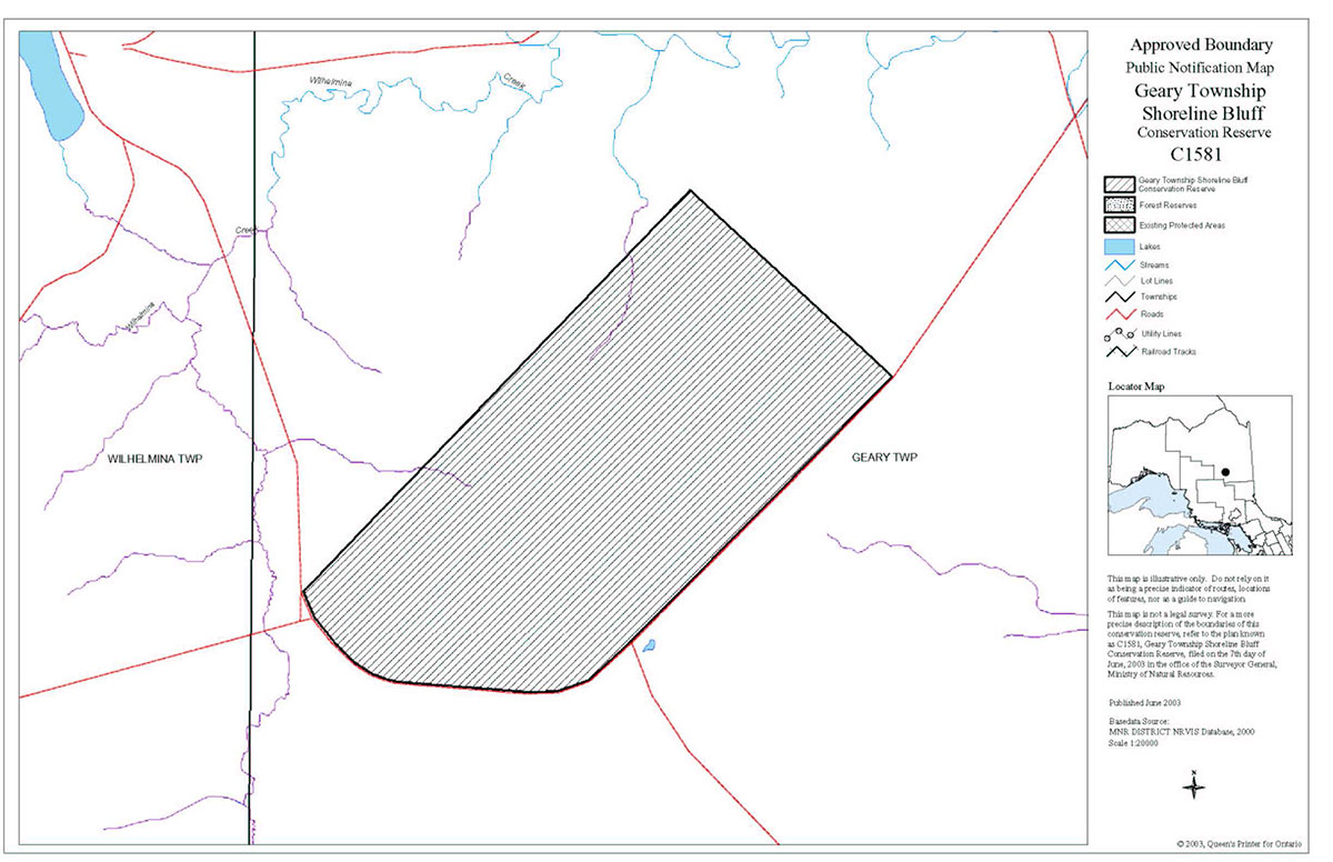
The 610 hectare Geary Township Shoreline Bluff Conservation Reserve is located approximately 45 kilometres northwest of the city of Timmins, Ontario, in the southeast corner of Geary Township, Ministry of Natural Resources (MNR) Timmins District, MNR Northeast Region in the Territorial District of Cochrane. The Geary Township Shoreline Bluff Conservation Reserve protects a provincially significant earth science feature, a shoreline bluff. It is thought that this erosional shoreline feature represents a water level of Glacial Lake Barlow – Ojibway or an earlier Glacial Lake Ojibway. The Geary Township shoreline bluff is a good example of a raised erosional shoreline (OMNR, 1999).
An approved Statement of Conservation Interest (SCI), an Enhanced Statement of Conservation Interest (Enhanced SCI), or a Resource Management Plan (RMP) will guide the management and administration of each conservation reserve. This SCI will provide the management direction for Geary Township Shoreline Bluff Conservation Reserve.
2.0 Goals and objectives
2.1 Goal
This Statement of Conservation Interest will be used to identify needs and guide key management activities towards protecting site-specific values and the overall ecological integrity of the Geary Township Shoreline Bluff Conservation Reserve. The management direction will protect the site’s natural heritage values and demonstrate its compatibility within the larger sustainable landscape. This direction will comply with the land use intent as stated by the Ontario’s Living Legacy Land Use Strategy (OMNR, 1997; OMNR, 1999).
2.2 Objectives
2.2.1 Short term objectives
The short-term objectives of this SCI are:
- To define the purpose of Geary Township Shoreline Bluff Conservation Reserve;
- To define the management intent for Geary Township Shoreline Bluff Conservation Reserve; and,
- To create public awareness of the values within Geary Township Shoreline Bluff Conservation Reserve and promote responsible stewardship of the protected area and surrounding lands.
This will be accomplished by:
- Identifying the state of the resource with respect to the protection of natural heritage values and current land use activities occurring within the Geary Township Shoreline Bluff Conservation Reserve; and,
- Determining land use compatibilities, thus creating the best management strategy to protect the integrity of identified values.
2.2.2 Long term objectives
The Statement of Conservation Interest (SCI) will determine the long-term management goals of the conservation reserve by identifying tourism and recreational use opportunities, research needs, client services and marketing strategies. By comparing scientific values found within Geary Township Shoreline Bluff Conservation Reserve to provincial benchmarks, representative targets (e.g. future forest conditions) can be determined for this site. Further monitoring or research needed to identify and to maintain the integrity of these characteristics can then be established.
The SCI will also provide direction to evaluate proposed new uses or economic ventures. To accomplish this, the Test of Compatibility shall be undertaken to determine the impact of the suggested use(s), either positive or negative, on the protected values and administrative needs of the conservation reserve (OMNR 1999; OMNR, 1997). The Test of Compatibility will provide rationale for decision-making within the entire site, further clarifying permitted uses within the Geary Township Shoreline Bluff Conservation Reserve.
3.0 Management planning
3.1 Planning context
3.1.1 Planning area
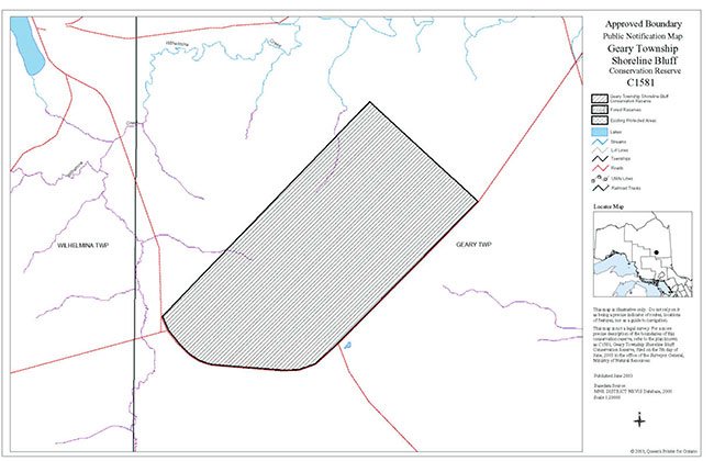
The planning area is the regulated boundary of Geary Township Shoreline Bluff Conservation Reserve (Map 8.1).
The planning area will form the area directly influenced by this Statement of Conservation Interest. The plan will recognize the protection of values within the planning area, however, to fully protect values within the conservation reserve additional consideration within larger land use or resource management plans may be required. Any strategies noted within this plan related to the site’s boundary or beyond will need to be presented for consideration within a larger planning context.
3.1.2 Management planning context
The need to complete the Parks and Protected Areas system has long been recognized as an important component of ecological sustainability (OMNR, 2000). This was reaffirmed in 1997 when the Lands for Life planning process was announced. Previous gap analysis studies were used to propose where candidate areas would protect additional representative life and earth science features. The Geary Township Shoreline Bluff was identified for its provincially significant earth science value (Kritjansson and Kor, 1997) and was subsequently identified in Ontario’s Living Legacy Land Use Strategy as C1581 (OMNR, 1999).
Conservation reserves are governed under Section 4 of the Public Lands Act and their lands and waters, as described in the Schedules, shall not be used for mining, commercial forest harvest, hydro-electric power development, the extraction of aggregates or peat or other industrial purposes (OMNR, 1997).
Permitted uses in conservation reserves follow the direction expressed in the Land Use Strategy while ensuring prior commitments made by Timmins District, Ministry of Natural Resources are met (OMNR, 1999). In time, the Land Use Strategy will be superceded by MNR's online Crown Land Use Atlas. The Permitted Uses Table (Appendix B) illustrates the variety of uses that could potentially occur in a conservation reserve. In cases where a use already occurs, it will be permitted to continue as per the Land Use Strategy (OMNR, 1997). Where a permitted use does not already exist in a specific conservation reserve, the permitted use would be considered a new use and subjected to the Test of Compatibility. Most recreational (e.g. hiking, boating, bird watching, hunting, fishing) and non-industrial resource uses (e.g. fur harvesting and bait harvesting) traditionally enjoyed in the area are permitted to continue.
Reflective of the management intent for Geary Township Shoreline Bluff Conservation Reserve, future uses or developments proposed for this conservation reserve will be reviewed using the Procedural Guideline B - Land Uses - Test of Compatibility found in Policy PL3.03.05 (OMNR, 1997). The Test of Compatibility is conducted to weigh the future use against the potential impacts to site values. Proposed uses and/or developments may also be screened using A Reference Manual for MNR Class Environmental Assessments: Resource Stewardship and Facility Development Projects.
Consideration for proposals pertaining to the development/ use of cultural resources may be screened through Conserving a Future For Our Past: Archaeology, Land Use Planning & Development In Ontario, Section 3 (Ministry of Citizenship, Culture and Recreation, 1997). Where necessary, the Ministry of Natural Resources will establish Area of Concern (AOC) descriptions and prescriptions for cultural heritage resources within forest management planning (FMPs).
These planning tools will help refine the review process once the proposal satisfies the direction and intent of the Public Lands Act, associated policies and this planning document.
3.2 Planning process
Following the completion of the land use regulation process, a planning exercise has occurred to determine the management direction for Geary Township Shoreline Bluff Conservation Reserve. Management of the conservation reserve includes, as a minimum, regulation, provision of public information, stewardship, and security. It also includes authorization and setting conditions on permitted uses and ongoing monitoring and compliance. Management of conservation reserves is the responsibility of the Ministry of Natural Resources at the District level, and will be done in accordance with Policy PL 3.03.05 (OMNR, 1997) and an approved management document.
A Statement of Conservation Interest is the minimum level of management direction established for any conservation reserve. If during the planning process major issues arise and/or it is recognized that decisions will need to be made beyond what is directed in the Land Use Strategy, a Statement of Conservation Interest increases to an Enhanced Statement of Conservation Interest or a Resource Management Plan. In either elevated management direction, specific permitted uses will be passed through the Test of Compatibility and decisions on future uses may be made beyond what is directed in the Land Use Strategy. To date, no issues have been identified in the Geary Township Shoreline Bluff Conservation Reserve that would require decisions to be made beyond what was previously determined in the Land Use Strategy.
This SCI will govern the lands and waters within the regulated boundary of the conservation reserve. To ensure Ministry of Natural Resources protection objectives are being fully met within the conservation reserve, the surrounding landscape and related activities must consider the site’s objectives and heritage values.
First Nations and the public were notified when the draft SCI was ready for review. Public review period began on January 17th, 2004 for a 15 day period. Notification occurred via mail-out to the First Nations and stakeholders. As well, an advertisement was placed in four local newspapers: Timmins Daily Press, Timmins Times, Les Nouvelles and Northern Daily News. 2 responses were received, focusing on the permitted uses within the site.
Where future reviews and revisions are necessary, public and First Nation consultation would occur and notification on the Environmental Bill of Rights Registry will be required. The Ministry of Natural Resources Timmins District will be responsible for ensuring this occurs.
4.0 Background information
4.1 Location and site description
4.1.1 Location and access
The Geary Township Conservation Reserve is located approximately 45 kilometres northwest of the city of Timmins in the southwest corner of Geary Township. This conservation reserve is bounded by both vectored and cultural boundaries. This site is accessible from Abitibi Main Road to the Red Pine Road (also known as Loveland Road). An old road/trail system running from the north in a southwest direction stops short of the site’s southern boundary road. Existing access by snowmobile, ATV, vehicle and aircraft are still permitted.
Table 1: Location and Administrative Details for Geary Township Shoreline Bluff Conservation Reserve
| MNR Administrative Region/District/Area | Northeast/ Timmins/ Mattagami |
|---|---|
| Total Area | 610 hectares |
| Regulation Date | May 21, 2003 |
| First Nations Interests | Flying Post First Nation |
| OBM Map Sheets | 20 17 4400 54000/ 20 17 4400 54100 / 20 17 4500 54000 |
| Canada Map Series | Manning Lake 42 A/13 |
| UTM Coordinates Centroid | 17 448697 5408419 |
| Territorial District | Cochrane |
| Municipality | Unorganized |
| Township | Geary |
| Status | 100% Crown Lands |
| Forest | Smooth Rock Falls Forest |
4.1.2 Physical site description
The Geary Township Shoreline Bluff Conservation Reserve is 610 hectares in size. Originally the conservation reserve was classified as Cochrane Site District 3E-3 (Hills, 1959) and has since been reclassified as Smokey Falls Ecodistrict 3E-1 in Lake Abitibi Ecoregion 3E (Crins and Uhlig, 2000) (Appendix A). It is also found in tertiary watershed 4LB of the Moose River Basin.
Key values are those values that make this site unique and have led to its designation as a conservation reserve. The key value within the Geary Township Shoreline Bluff Conservation Reserve is the:
- Provincially significant shoreline bluff earth science value.
This shoreline bluff is comprised of a provincially significant beach and lagoon earth science feature. The shoreline bluff trends approximately SW-NE and has been cut into a till covered upland area. The upland area is immediately underlain by a compact, fissile, gravelly, silt till. Furthermore, the white birch mixedwood stands found on the earth science feature may also be provincially significant (Kor, 2001).
4.1.3 Administrative description
The legal description of the Geary Township Shoreline Bluff Conservation Reserve has been regulated as Schedule 181 in Ontario Regulation 208/03 under the Public Lands Act on May 21, 2003 and amended Ontario Regulation 805/94.
4.2 Site history
The preliminary analysis suggests that the Geary Township Shoreline Bluff Conservation Reserve includes the western side of what was once an island in glacial Lake Barlow-Ojibway or an earlier glacial lake while the erosional shoreline bluff represents a water level of glacial Lake Barlow-Ojibway or an earlier glacial lake. This island or upland area is composed of a silty clay to clayey silt till which divides the shoreline bluff in a southwest-northeast trend. The lowland area below the shoreline bluff, which historically contained the glacial lake, is composed of a glaciolacustrine plain made of silt and fine sand (Noordhof et al., 2003).
4.3 Inventories
Three inventories have been completed for the Geary Township Shoreline Bluff Conservation Reserve:
- Earth science checksheet by Ontario Parks (Kor, 2001)
- Recreation inventory checklist by Timmins District MNR (Baker and Thompson, 2001)
- Life science checksheet by MNR Northeast Region (Noordhof et al., 2003).
5.0 State of the resource
The natural heritage of Ontario contributes to the economic, social and environmental well-being and health of the province and its people. Protecting areas of natural heritage is therefore important for many reasons, such as maintaining ecosystem health and providing habitat in order to maintain species diversity and genetic variability. Protected areas also provide scientific and educational benefits. They generate tourism, thereby bolstering local and regional economies, and provide places where people can enjoy and appreciate Ontario’s natural
5.1 Representation
The Geary Township Shoreline Bluff Conservation Reserve has been identified to protect a provincially significant shoreline bluff. The Geary Township Shoreline Bluff Conservation Reserve has provincial significance and is considered an important representative feature of Ontario’s glacial history and earth science diversity.
5.1.1 Life science
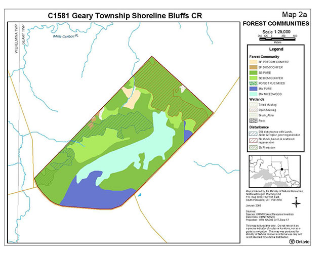
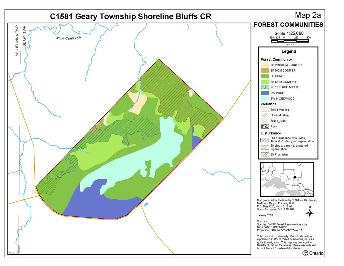
The Forest Resource Inventory (FRI) data and the reconnaissance survey differ on what is present within Geary Township Shoreline Bluff Conservation Reserve. The FRI data shows pure black spruce stands occupying the majority of the conservation reserve. However, during the reconnaissance survey, it was noted that western and northeastern harvested areas of the conservation reserve are regenerating poorly as larch, alder shrubs, and poplar in the west and black spruce shrub in the northeast (Photo 1). Black spruce dominant conifer stands are also present within the site but to a lesser degree and are situated in pockets in the northern and southeastern parts of the conservation reserve.
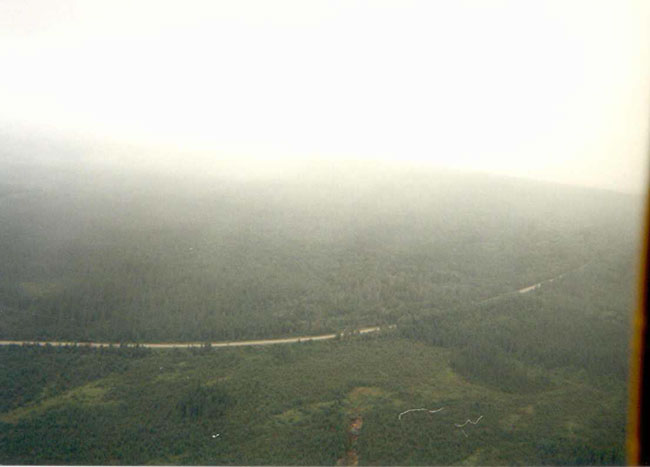
White birch is the second most common species living within this conservation reserve and emerges as pure and mixedwood stands (Map 8.2.1). Pure white birch stands are found in the southwest corner of the site and a small area in the southeast along the southern boundary. To its east, white birch mixedwood stand extends in a southeast direction almost reaching the southeast corner of the site (Photo 2). Balsam fir also occurs as predominant conifer and dominant conifer stands along the northern boundary and in association with wetland communities. A 0.01 hectare poplar/black spruce true mixed stand also exists within the boundaries of the conservation reserve. The shoreline bluff feature divides the white birch communities and the lowland black spruce communities where the white birch communities are situated along the shoreline bluff feature and extend onto the till deposits while the balsam fir stands are confined to the glaciolacustrine deposits below the shoreline bluff feature.
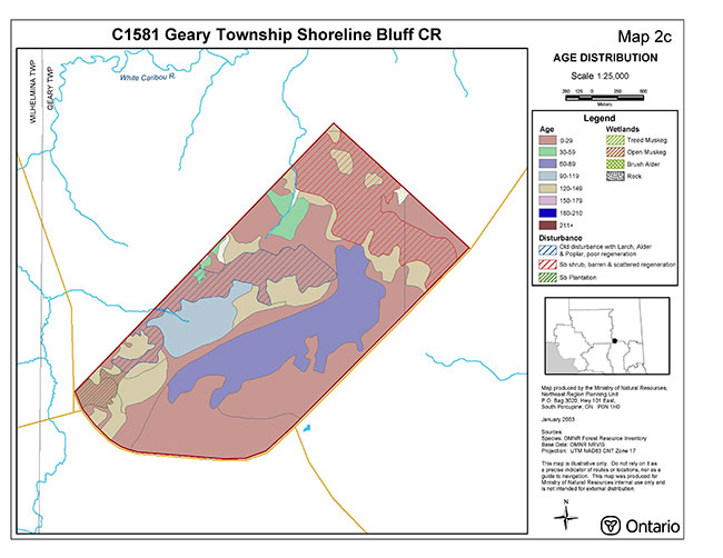
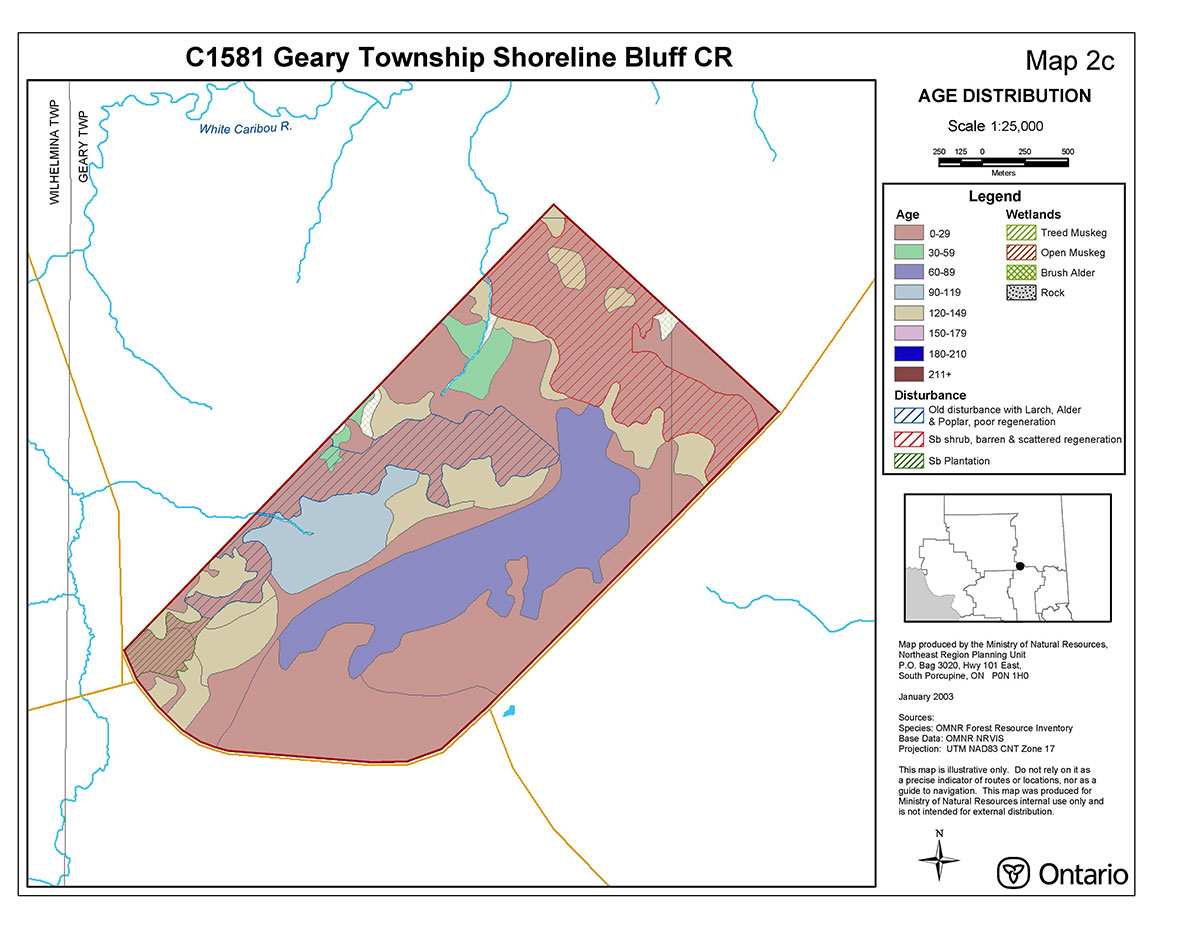
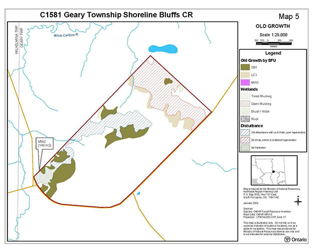
Within the Geary Township Shoreline Bluff Conservation Reserve, the majority of the tree stands were aged between 0-29 years (Map 8.2.2), reflecting past harvesting activities. These disturbed areas are regenerating poorly and are composed of sparse shrubs and young poplar and larch communities. Less disturbed areas include stands aging 30-59, 60-89, and 90-119 years. Old growth communities comprised in the site are 120-149 years of age and include black spruce stands (Map 8.2.3). During the reconnaissance survey, old growth white pine was observed east of the beach ridge, which was not picked up in the FRI data (Noordhof et al., 2003).
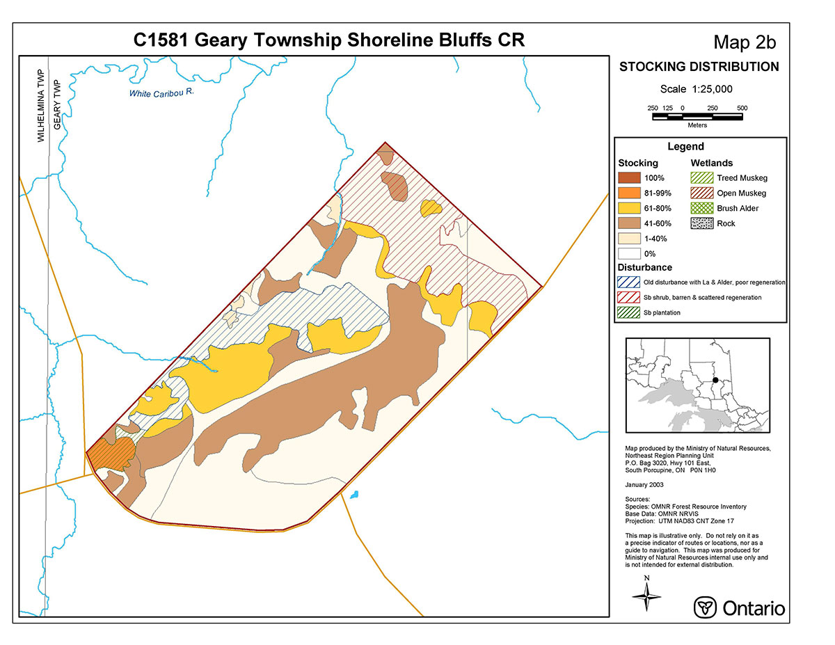
Previous harvesting has impacted stocking within the conservation reserve as these areas are regenerating sparsely and are stocked between 1 and 40 percent (Map 8.2.4). The majority of the remainder of the site is stocked between 41 and 80 percent although a small stand of pure black spruce in the northwest corner is stocked between 81 and 99 percent (Noordhof et al., 2003).
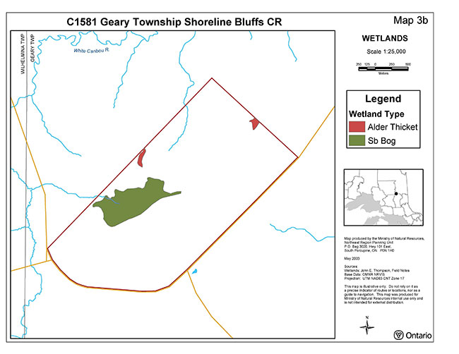
The Geary Township Shoreline Bluff Conservation Reserve falls within the Moose River Basin in tertiary watershed 4LB (OMNR, 2002). This conservation reserve does not contain, or border, any lakes however, two small creeks in the northeastern corner feed north into White Caribou River. Wetland communities include small alder thickets located in northeast and northwestern portions of the conservation reserve (Map 8.2.5). In the western part of the conservation reserve there is a black spruce dominant conifer stand that is considered to be better represented as a black spruce bog.
Photo 1: Eastern boundary
(John Thompson, 2001)
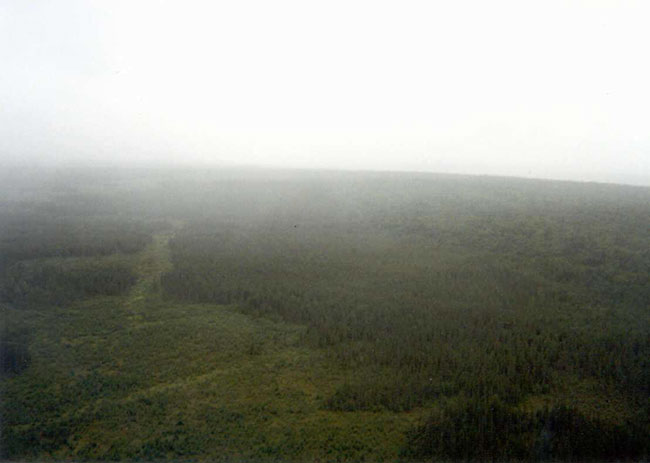
Photo 2: Eastern boundary along Abitibi Main Road
(John Thompson, 2001)
5.1.2 Earth science
The Geary Township Shoreline Bluff Conservation Reserve is found within the Abitibi upland physiographic region. This region contains broad rolling surfaces that reach about 1500 feet near its southern borders and is underlain by crystalline Archean rocks (Bostock, 1970). The provincial landform coverage shows this conservation reserve to be completely covered by lacustrine deposit.
The Geary Township Shoreline Bluff Conservation Reserve has been identified for its provincially significant earth science representation of a beach and lagoon feature formed on an island in glacial Lake Barlow-Ojibway/Ojibway. Although other such beach features occur scattered throughout the region, the features in C1581 are relatively accessible, interpretable, and occur north of the drainage divide, where such features are not as common (Kor, 2001).
A small shoreline bluff (Photo 3) and beach bar occur at the base of a till-covered (compact, clast-poor, carbonate till) bedrock knoll (Kor, 2001). The till was deposited during the Cochrane Events of the Holocene Postglacial and Recent Environmental Theme. A small lagoon is enclosed by this beach feature at the southern end of this knoll and represents a shoreline feature formed on an island in glacial Lake Barlow-Ojibway, or early glacial Lake Ojibway (Photo 4). Mafic and felsic metavolcanic rocks underlie but are not exposed in the site. Diamond drilling of these rocks in the vicinity has yielded numerous base metal mineral showings (Bright and Hunt, 1971).
Photo 3: Shoreline bluff
(Daraleigh Irving, October 2003; Joel Holder, August 2003)
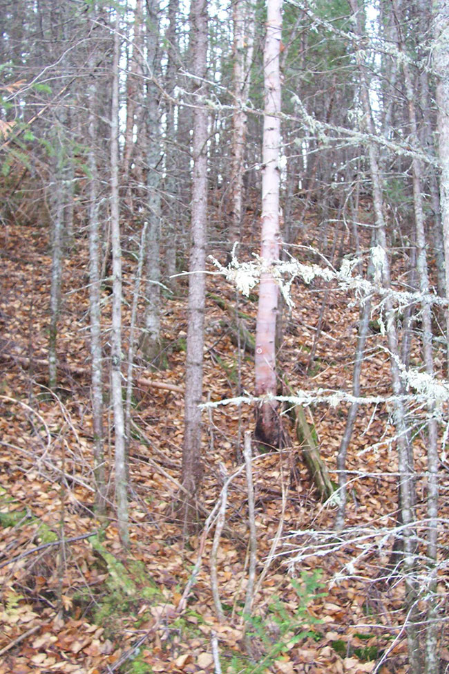
Photo 4: Beach feature at southern end of shoreline bluff
(Daraleigh Irving, October 2003; Joel Holder, August 2003)
5.1.3 Quality of present representation
The quality of the representation or the current characteristics of the natural features found within the conservation reserve are as important as the overall representative features that are being protected. A number of criteria are considered in evaluating a site including: diversity, ecological factors, condition, special features and current land use activities.
a) Diversity
Diversity is a measure of the site’s life and earth science heterogeneity. It is based on the number and range (variety) of the natural landscape features and landforms of earth science values and the richness and evenness of the life science component. No life science gap analysis was conducted for this conservation reserve, since the site was originally identified as a provincially significant earth science site protected for the shoreline bluff value (Kristjansson and Kor, 1997). Consequently, a historical diversity rating is not available.
Based on the forest communities map, seven forest communities exist within Geary Township Shoreline Bluff Conservation Reserve. The Black spruce forest community dominates over half the area within the conservation reserve (Noordhof et al., 2003). From these observations and considering the lack of wetland representation, the diversity of this conservation reserve is considered to be low.
With further analysis, the conservation reserve remains dominated by black spruce communities and also shows the good dispersion of the black spruce communities. The site maintains a low diversity rating with a ranking of 8.
The original analysis of the conservation reserve showed the conservation reserve as having 7 landform:vegetation combinations at the site’s original size of 571 hectares. All 7 vegetation classes were found on lacustrine deposits. At the larger size (610 hectares), the preliminary analysis of landform coverage suggests the conservation reserve consists of till-covered upland areas, glaciolacustrine deposits in the lowland areas and a shoreline bluff. After combining all recent analyses, 10 landform: vegetation combinations were found within Geary Township Shoreline Bluff Conservation Reserve and the site maintains a low diversity rating (Noordhof et al., 2003).
b) Ecological factors
Ecological factors refer to current design of the conservation reserve including its size, shape and the ability of the site to maintain itself over time (Thompson, 1999). The ability of a site to buffer the core areas from adjacent land uses, its general location and its location within the greater managed ecosystem will influence the site’s viability over time and be important factors in maintaining overall ecosystem health.
The Geary Township Shoreline Bluff Conservation Reserve is small (610 hectares), thereby less than the 2000 hectare minimize size established by Ontario Parks (OMNR 1992) to protect representative landscapes as well as allow for low intensity recreational activities. Two boundaries clearly identify the southern and eastern boundaries. The western and northern boundaries are vectored and decrease the site’s ability to protect representative values.
Since the shoreline bluff is relatively small and found in the centre of Geary Township Shoreline Bluff Conservation Reserve, the boundaries still protect the site from adjacent land uses; thereby, ensuring core values are protected.
c) Condition
Condition is the degree of past human and natural disturbances observed or recorded for the site. A low-use ATV trail exists within Geary Township Shoreline Bluff Conservation Reserve, yet the beach feature (i.e. shoreline bluff) described is still well-preserved. The beach feature may be susceptible to erosion if the vegetation cover is further disturbed because of the fine grain size and poor drainage (Kor, 2001).
Geary Township Shoreline Bluff Conservation Reserve has been previously harvested and is slowly regenerating. The northeastern and western boundaries along with portions of the conservation reserve’s interior have been impacted heavily as little regeneration has occurred in the old harvest blocks. In the western portions of the conservation reserve, minimal regeneration is represented as larch, alder shrubs and poplar whereas the cut in the northeast is poorly regenerating as black spruce shrub. The spruce plantation in the southwest corner of the site has regenerated well. The old road/trail system found primarily at the base of the shoreline bluff emerges from the southeast and runs westwardly through the centre of the site has also contributed to disturbance within the conservation reserve. Both southern and western boundaries are well-developed roads (Noordhof et al., 2003).
d) Special features
Special features may include interesting landscapes, habitats or vistas, Species at Risk (SAR) and other earth and life science features such as broader landscape elements that contribute to the natural heritage richness of Ontario. For Geary Township Shoreline Bluff Conservation Reserve, the special features include a provincially significant shoreline bluff. No SAR have been identified to date within the site.
e) Current land use activities
Current land uses include hunting and trapping.
5.2 Social/economic interest
This section addresses the contribution of the Geary Township Shoreline Bluff Conservation Reserve to the local economy and society through the opportunities it represents and the importance of these opportunities.
5.2.1 Local communities
The Geary Township Shoreline Bluff Conservation Reserve is south of the community of Smooth Rock Falls and north of the city of Timmins. This area provides minimal recreational/commercial opportunities for the residents of and visitors to the area.
During the hunting season, tourism brings economic benefits to the Community of Smooth Rock Falls and the City of Timmins as well as to the local outfitters. Other recreational/commercial activities that may be found within the Geary Township Shoreline Bluff Conservation Reserve include snowmobiling, hunting, ATVing, nature study, big tree observation, viewing and exploring (Baker and Thompson, 2001).
5.2.2 First nations
Geary Township Shoreline Bluff Conservation Reserve is located within James Bay, Treaty #9. Flying Post First Nation has the closest reserve to Geary Township Shoreline Bluff Conservation Reserve. Aboriginal Treaty and Traditional Rights will be adhered to.
5.2.3 Ministry of Northern Development and Mines and the Mining Industry
In March 2002, the Ministry of Northern Development and Mines and the Ministry of Natural Resources came to a joint decision regarding mining issues and Ontario’s Living Legacy sites. No new exploration will be permitted on Crown land within OLL sites in the future.
5.2.4 Other government agencies, departments or crown corporations
Ministry of Natural Resources Timmins District is working with the East Fire Region – Timmins Fire Management Headquarters to develop a fire management direction that protects the values found within the conservation reserve. The current fire management strategy identifies Geary Township Shoreline Bluff Conservation Reserve within the intensive zone. Within the intensive zone, full suppression mandates that every fire must receive a response and is actioned aggressively.
5.2.5 Non government organizations and other industry interests
Both the Partnership for Public Lands (PPL) and the Ontario Federation for Anglers & Hunters (OFAH) have identified an interest in the Geary Township Shoreline Bluff Conservation Reserve.
5.3 Natural heritage stewardship
The Geary Township Shoreline Bluff Conservation Reserve’s distinct contribution is a combination of earth science/glacial history preservation, and educational and recreational opportunities. The Geary Township Shoreline Bluff Conservation Reserve also offers scientists, educators and recreational opportunities to learn about the site and enjoy its value. Geary Township Shoreline Bluff Conservation Reserve should be recognized for its provincially significant earth science feature and measures should be considered to minimize further impacts to the site (Kor, 2001).
By allocating these lands to the parks and protected areas system through regulation, the province has ensured permanent protection for the conservation reserve and its values from industrial activities that may exist in the larger general use or more extensively managed landscape.
5.4 Fisheries and wildlife
Geary Township Shoreline Bluff is found within Wildlife Management Unit (WMU) 30. Game and furbearer species which inhibit WMU 30 include furbearers (e.g. beaver, lynx, weasel, fisher and marten), large mammals (e.g. moose and black bear) and birds (e.g. ruffed and spruce grouse).
Wildlife values for this site include a trapline (CC61), a bear management area (CC-30-015) and a moose early wintering area. Unnamed streams entering the north of the site have unknown fisheries.
5.5 Cultural heritage stewardship
There are no known cultural heritage values within the Geary Township Shoreline Bluff Conservation Reserve though no detailed research has been conducted as of this date to document possible cultural heritage values. Cultural heritage values may be present within the conservation reserve.
5.6 Land use/current or past development
Mining and surface rights have been withdrawn from staking within the conservation reserve boundaries under the Mining Act (RSO 1990 Chapter M.14).
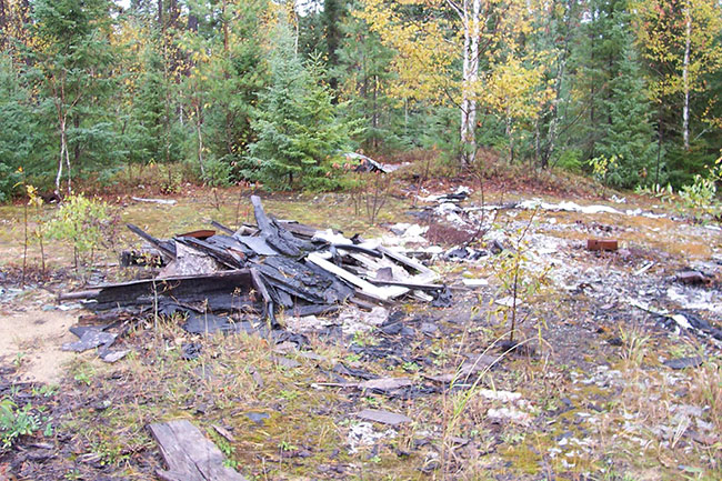
One old trapping cabin exists within the southeast corner of the conservation reserve, along the main road. This old trapper’s cabin has been burned to the ground and a shed and garbage remains at the site (Photo 5 & 6).
Photo 5: Garbage in shed
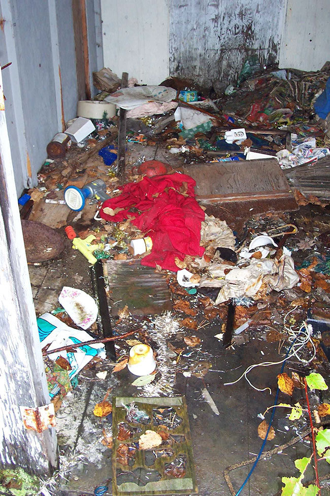
Photo 6: Burned down cabin
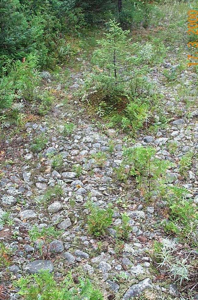
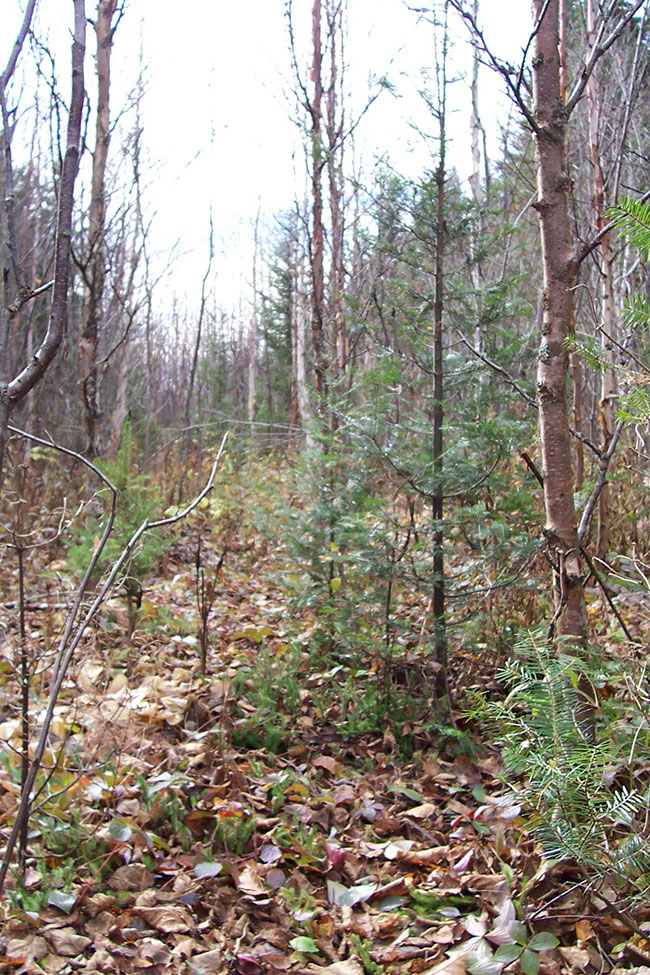
The old road/trail system is still present within the site, although it is extremely difficult to locate. In time, immature alder, balsam fir, black spruce, and tamarack will overtake the road/trail system (Photo 7).
Photo 7: Trail regenerating
(Daraleigh Irving, October 2003)
5.7 Commercial use
The commercial use of the Geary Township Shoreline Bluff Conservation Reserve includes hunting and fur harvesting. Other commercial uses such as forestry, hydroelectric development, mining activities and aggregate operations do not occur within this site and are no longer permitted within the conservation reserve.
5.8 Tourism/recreational use/opportunities
Current recreational uses and opportunities of the site include snowmobiling, ATVing, hiking, nature study, big tree observation, viewing and exploring (Baker and Thompson, 2001). There are currently no new proposals for recreational or tourism uses for this site.
Under Management Guidelines for future proposals, an evaluation of any proposal should include the following:
- Ensure natural heritage values identified herein are protected and the Test of Compatibility from PL 3.03.05 (OMNR, 1997) is used,
- Different options are proposed for the development including the null option
- No change in use to be considered without public and Aboriginal consultation.
5.9 Client services
Visitor services will primarily deal with responding to inquires about the basic level of information such as natural heritage representation and appreciation, wildlife viewing opportunities, access and boundaries. The role of Geary Township Shoreline Bluff Conservation Reserve within the greater provincial parks and protected area system will be addressed when meeting with clients.
6.0 Management guidelines
6.1 Management planning strategies
Once established, protected areas will be managed to retain and/or restore natural features, processes and systems. They will also meet previous commitments identified in Ontario’s Living Legacy Land Use Strategy and provide opportunities for compatible research, education and outdoor recreation activities (OMNR, 1999). Management and protection of the site will be under the direction of the Timmins District MNR Mattagami Area Supervisor. The management of this conservation reserve will meet the goal of protecting the natural heritage features while permitting compatible activities to continue by screening proposals through the Test of Compatibility. Other types of proposed development would require a detailed Test of Compatibility to be conducted to ensure that the features would not be impacted in any way. These types of assessments would occur on a case-by-case basis by the Mattagami Area Team, Timmins District MNR. Management strategies will also be consistent with the objectives of increasing public awareness, promoting responsible stewardship, providing marketing opportunities, and identifying inventory, monitoring, assessment and reporting potential.
6.2 "State of the resource" management strategies
The following section will describe specific management strategies to maintain, protect and enhance the existing natural heritage values and land use activities of the Geary Township Shoreline Bluff Conservation Reserve. A complete list of permitted activities can be found in the permitted use tables (Appendix B).
6.2.1 Natural heritage stewardship
Natural heritage values will be managed in such a way as to mitigate and prevent any further damage to either the earth science features or the life science values. All earth science and life science features will be protected by defining compatible uses, enforcing regulations and monitoring and mitigating issues.
No additional construction, maintenance, or further upgrade to trails will be permitted.
The MNR recognizes fire as an essential process in the maintenance and renewal of ecological and ecosystem health of conservation reserves. In accordance with existing Conservation Reserve Policy and the Forest Fire Management Strategy for Ontario, forest fire protection will be carried out as on surrounding lands.
Whenever feasible, the MNR fire program will endeavour to use "light on the land" techniques, which do not unduly disturb the landscape, in the Geary Township Shoreline Bluff Conservation Reserve. Examples of "Light on the land" techniques may include, and are not limited to:
- Using natural openings for helicopters pads
- Ensuring camp locations are built outside the conservation reserve; and/or
- Limiting the use of heavy equipment within the conservation reserve
Fire and resource managers will identify those areas in which, and the specific conditions under which prescribed fires may be used to meet ecological or resource management objectives. These management objectives will be developed with public consultation prior to any prescribed burning, and reflected in future refinements of this SCI. Plans for any prescribed burning will be developed in accordance with the MNR Prescribed Burn Planning Manual, and the Class Environmental Assessment for Provincial Parks and Conservation Reserves (approval pending) (OMNR 2003b).
The introduction of exotic and/or invasive species will not be permitted. Programs may be developed to control forest insects and diseases in the conservation reserve where these threaten significant heritage, aesthetics, or economic values. Where control is desirable and possible, it will be directed as narrowly as possible to the specific insect, disease or plant. Where action is necessary, biological control will be the preferred option whenever feasible.
Vegetation communities should not be disturbed any further through unnecessary clearing or fuelwood collection. Natural succession will be allowed to occur through passive management.
The collection/removal of native vegetation and parts thereof will not be permitted. However, subject to the Test of Compatibility, the Area Supervisor may authorize the collection of plants and/or parts for the purposes of rehabilitating degraded sites within the reserve if required and for research or scientific study.
For this site to continue to contribute as a heritage estate through its permanent protection of our earth science/glacial history, the permitted uses need to be enforced. The site should be promoted for its educational opportunities. The role of this landform as a provincial benchmark should be studied further and studies should be conducted to determine possible rare, vulnerable or threatened species habitat. Natural forest succession could be monitored to determine the natural climax community.
Timmins District MNR will provide leadership and direction for maintaining the integrity of this site as a protected area. Research, protection, education and interpretation of natural heritage features of the site will be encouraged and fostered through local and regional natural heritage programs and initiatives.
6.2.2 Fisheries and wildlife
Fisheries and wildlife resources will continue to be managed in accordance with policies and regulations prevailing in the area and under the direction of the Area Supervisor. Provincial legislation and policies will dictate management and enforcement objectives for this conservation reserve.
Existing trapping and hunting will be permitted to continue by local outfitters and the general public. First Nation Treaty Rights with respect to fish and wildlife activities will be respected as described in Section 6.2.8 Aboriginal Interests. New commercial outfitting, outpost, hunting camps or trap cabins will not be permitted within the boundaries of the conservation reserve.
6.2.3 Cultural heritage values
It is not known if cultural heritage values exist in the Geary Township Shoreline Bluff Conservation Reserve, however, if values are confirmed, management would be consistent with Conserving a Future For Our Past: Archaeology, Land Use Planning & Development In Ontario (Ministry of Citizenship, Culture and Recreation, 1997). Research and studies should be conducted to determine the potential and/or existence of cultural or archeological resources.
6.2.4 Social/economic interest
The economic contribution of the Geary Township Shoreline Bluff Conservation Reserve to the local communities will be minimal.
Socially, this area provides recreational opportunities for the local people and tourists to enjoy for their own health and well-being. The people of Ontario will generally benefit from this conservation reserve through direct enjoyment of the area or through the knowledge that a component of our earth science and glacial history has been preserved. Other interest groups, such as colleges and universities, can benefit from this conservation reserve as a place to study natural features and processes.
6.2.5 Land use/past and existing development
No road realignments, telecommunications and resource networks will be allowed to cross the Geary Township Shoreline Bluff Conservation Reserve and interrupt its natural state.
The sale of land and creation of new recreation camps will not be permitted within the conservation reserve.
The burned down trap cabin will be removed and the site will be rehabilitated.
6.2.6 Commercial activities
Commercial activities such as fur harvesting, baitfish harvesting and bear management areas will be managed according to prescriptions in the Land Use Strategy (OMNR, 1999). Trapline operations will be permitted to continue since there are no demonstrated conflicts between these activities and the values being protected. Existing bear management areas will be permitted to continue, including license transfer; however, new operations will not be permitted as per the Land Use Strategy (OMNR, 1999).
Commercial forest harvest, hydroelectric development, mining activities and aggregate extraction are not permitted within the conservation reserve.
6.2.7 Tourism/recreation
The tourism and recreation opportunities present in the Geary Township Shoreline Bluff Conservation Reserve will be managed by permitting current activities to continue unless shown to have significant impact on site values as per the Land Use Strategy (OMNR, 1999). Current activities include bird watching, hunting, hiking, camping, ATVing and snowmobiling.
6.2.8 Client services
Under the direction of the Mattagami Area Supervisor, Timmins District staff will respond to public, non-government organizations (NGOs), industry and MNR partner requests for basic information on Geary Township Shoreline Bluff Conservation Reserve. Interpretative pamphlets may be developed and made available at Timmins District office.
6.3 Promoting inventory, monitoring, assessment, reporting and research
The Geary Township Shoreline Bluff Conservation Reserve provides educational opportunities through its existence. Scientific research by qualified individuals or institutions, which contributes to the knowledge of natural and cultural history and to environmental and recreational management, will be encouraged. Requests or applications to conduct research will be filtered through the Timmins District MNR Mattagami Area Team, to ensure that the studies are non-invasive and that no values will be damaged in the research process. Research programs will be subject to ministry policies and other legislation.
Approved research activities and facilities will be compatible with the protection objective. Permanent plots or observation stations may be established for long-term trials. The Ministry of Natural Resources may approve the removal of any natural or cultural specimen by qualified researchers. Any materials removed will remain the property of the Ministry of Natural Resources. Any site that is disturbed will be rehabilitated as closely as possible to its original state.
Other specific research projects that could be undertaken may include: the effects of human disturbance on the landform, determination of the existence of any rare, vulnerable or threatened species, vegetation climax community, or wind throw and harvest area re-growth. Additional life and earth science inventories may be completed.
6.4 Implementation and plan review
This Statement of Conservation Interest will take effect immediately following approval by the Northeast Regional Director. Implementation activities will primarily involve monitoring to ensure adherence to the management guidelines. Other implementation activities will include the removal of the abandoned trap cabin, the potential creation of a fact sheet or pamphlet to be placed at the MNR District office, and responding to any inquiries about the site. Implementation of this Statement of Conservation Interest and management of the conservation reserve are the responsibility of the Mattagami Area Supervisor and area staff in Timmins. Compliance activities will be identified and prioritized in the Timmins District Annual Compliance Operation Plan.
This Statement of Conservation Interest should be reviewed in 5 years to determine if it is providing adequate direction and protection for the natural heritage values. If changes in management direction are needed at any time, the significance of the changes will be evaluated. Minor changes, which do not alter the overall protection objectives, may be considered and approved by the Area Supervisor without further public consultation and the management direction will be amended accordingly. In assessing major changes, the need for a more detailed Enhanced SCI or Resource Management Plan (RMP) will first be considered. Where a management plan is not considered necessary or feasible, a major amendment may be considered with public consultation. The Regional Director will be required to approve major amendments. The SCI or future RMP, if required, plus the Land Use Atlas will be amended to reflect any changes in management direction.
Inventory, monitoring, assessment, and reporting should be ongoing and findings should be amended to the Statement of Conservation Interest as the studies are completed or at the time of the 5 year review. After the initial review, and dependent on study findings, a new schedule for review will be determined. Additional planning will be linked to the inventory, monitoring, assessment, reporting, research findings and any new information. Adaptive management strategies will be used when new information has a significant effect on the current Statement of Conservation Interest.
6.5 Marketing
The Geary Township Shoreline Bluff Conservation Reserve will be marketed as a distinctive protected area having a provincially significant earth science shoreline bluff. Fact sheets may be prepared to inform the public about these values, the permitted uses and the restrictions, which will then become available at the Timmins District MNR office. Marketing efforts to increase use are not an objective and will be kept to a minimum.
7.0 References
Baker, R. and Thompson, J.E., 2000. Recreation Inventory Checklist: C1581 Geary Township Shoreline Bluff Conservation Reserve. Ontario Ministry of Natural Resources.
Bostock, H.S., 1970. Geology and economic minerals of Canada – Part A.
Bright, E.G., and Hunt, D.S., 1971. Pamour Sheet, District of Cochrane; Ontario Department of Mines and Northern Affairs, Preliminary Map P.698, scale 1" = 2 miles.
Crins, W.J., and Uhlig, P.W., 2000. Ecoregions of Ontario: Modifications to Angus Hills' Site Regions and Districts. Ontario Ministry of Natural Resources.
Hills, G.A., 1959. A Ready Reference to the Description of the Land of Ontario and its Productivity. Ontario Department of Lands and Forests.
Kor, F.J., 2001. Earth Science Inventory Checklist – Geary Township Shoreline Bluff Conservation Reserve C1581. Ontario Ministry of Natural Resources.
Kristjansson, F.J. and Kor, P.S.G., 1997. Conservation Geology of Selected Sites in Northeastern Ontario. Ontario Ministry of Natural Resources.
MCZCR, 1997. Conserving a Future For Our Past: Archaeology, Land Use Planning & Development in Ontario. Ministry of Citizenship, Culture and Recreation.
Noordhof, J., Thompson, J.E., King, L., and Longyear, S., 2003. Geary Township Shoreline Bluff Conservation Reserve (C1581): Life Science Checksheet – Step 4. Ontario Ministry of Natural Resouces.
OMNR, 1997. Conservation Reserves Policy 3.03.05. Ontario Ministry of Natural Resources.
OMNR, 1999. Ontario’s Living Legacy Land Use Strategy. Ontario Ministry of Natural Resources.
OMNR, 2000. Beyond 2000 MNR Strategic Direction. Ontario Ministry of Natural Resources. Peterborough, Ontario.
OMNR, 2002. MNR districts and major basins of Ontario. Ontario Ministry of Natural Resources.
OMNR, 2003a. A Class Environmental Assessment for MNR Resource Stewardship and Facility Development Projects. Ministry of Natural Resources Environmental Assessment Report Series. Ontario Ministry of Natural Resources. Queen’s Printer.
OMNR, 2003b. A Class Environmental Assessment for Provincial Parks and Conservation Reserves. Ministry of Natural Resources Assessment Report Series. Ontario Ministry of Natural Resources. Queen’s Printer.
Poser, S.F., 1992. Report on the Status of Provincial Parks in Site Regions and Districts of Ontario. Ontario Ministry of Natural Resources.
Rowe, J.S., 1972. Forest Regions of Canada. Department of Fisheries and the Environment, Canadian Forestry Service.
Thompson, J.E., 1999. Cheatsheet "Building the System". Ontario Ministry of Natural Resources.
8.0 Maps
8.1 Planning area
8.2 Life science checksheet maps
8.2.1 Species composition
Enlarge Species composition map
8.2.2 Age distribution
8.2.3 Old growth
8.2.4 Stocking

8.2.5 Wetlands
9.0 Appendices
9.1 Appendix A: physical site description
Table 2: Physical site description
| Site Region | Lake Abitibi Site Region / Ecoregion – 3E |
|---|---|
| Characteristics | Moderately to gently rolling bedrock, generally covered by deep deposits of clay, silt and sand (Hills, 1959). |
| Site District | Cochrane Site District 3E-3 (Hills, 1959), redefined as Smokey Falls Ecodistrict 3E-1 (Crins, 2000) |
| Characteristics | Smooth plain of clay and loam, moderate to high in lime, shallow to moderately deep over bedrock with a fairly high percentage of muskeg (Hills, 1959; Poser, 1992). |
| Climate | Mid-humid, mid-boreal (Hills, 1959; Poser, 1992). |
| Forest Section | Northern Clay Boreal Forest Section |
| Vegetation | Black spruce stands dominate rising uplands; co-inhabit with sedge fens and sphagnum-heath bogs; tamarack occasionally found with black spruce; in swamp areas, cedar dominants along borders, black spruce also exists; areas with shallowly buried coarse drift or river or lake edges have pockets of hardwood or mixed wood communities comprising trembling aspen, balsam popular, balsam fir, white spruce and black spruce; on sandy soils, stands of jack pine and white birch are found; drier sites such as old beaches, eskers, and outwash deposits exhibit stands of jack pine and white birch are found on sandy soils (Rowe, 1972). |
9.2 Appendix B: conservation reserves policy
Amended by Ontario’s living legacy land use strategy, september 26, 2000
Introductory notes:
- According to conservation reserve policy, and statements made in the Ontario’s Living Legacy Land Use Strategy (LUS), all uses within conservation reserves are subject to a "test of compatibility", that is, the use must be compatible with the conservation of the ecological features for which the site was identified (e.g., landforms, vegetation communities, hydrology, species, etc);
- The following detailed clarification of conservation reserve policies should be read in the context of the general policies, and notes on Aboriginal rights, that are outlined at the beginning of the paper.
Definitions:
- Existing Policy: Statements of policy for conservation reserves established prior to the OLL-LUS, primarily as outlined in the Conservation Reserve Policy and Procedure, February 1997.
- OLL-Land Use Strategy Policy: Statements of policy in the LUS applicable to the recommended conservation reserves in the OLL planning area.
- Policy Clarification: Statements that clarify policy direction with respect to new and/or existing OLL conservation reserves within the OLL planning area.
Industrial activities
| Issue and Activity | Existing Policy | OLL: Land Use Strategy Policy | Policy Clarification |
|---|---|---|---|
| Commercial timber harvest | Not permitted | Not permitted | Consistent with existing policy |
| Cutting of trees by leaseholders, cottagers and other property owners for fuelwood and other small-scale uses | No explicit policy | No policy stated | No fuelwood permit will be authorized by the Mattagami Area Team. |
| Timber salvage/sunken log retrieval | No explicit policy | No policy stated | If provided for in an SCI or RMP, standing, fallen or sunken trees may be removed for resource management purposes. Such trees may be marketed if economical. |
| Mineral exploration | Not permitted | Not permitted | Consistent with existing policy. |
| Mining | Not permitted | Not permitted | Consistent with existing policy. |
| Extraction of peat, soil, aggregate, other materials | Not permitted | No policy stated; existing policy applies | N/A |
| Forest renewal | Forest renewal is not directly addressed in existing policy as it is an activity associated with commercial timber harvesting which is not permitted in conservation reserves. | Not directly addressed | This issue arises where a new conservation reserve was cut recently, and there is a question as to whether the forest company should carry out planned forest renewal work. MNR's position is that the companies have harvested the areas, and have an obligation to proceed with renewal, unless this requirement is waived by MNR. If renewal is to occur, the work should normally be carried out by the forest company. Any possible renewal should be reviewed to determine the nature of the renewal proposal and the possible implications for protected area values. Renewal can be conducted where it will be of net benefit to the protected area. To the greatest extent possible, the renewal should be designed to replicate natural conditions (e.g., if planting is carried out, the more random the planting, the better), although the company cannot be expected to carry out renewal that would be beyond the cost of normal renewal activities. Tending should be considered on a case-by-case basis and be driven by the desired outcome of renewal. In all cases of proposed renewal activities, there must be prior review and approval of the proposals by appropriate silvicultural and program staff responsible for the management of the protected area, in order to determine what actions would best support the long-term ecological integrity of the area. |
| Hydro power generation | Not permitted | Not permitted | N/A |
| Communications corridors | Existing use permitted to continue; new corridors to be discouraged through planning. | No policy stated; existing policy applies | The intent of the policy is to actively discourage these uses, but it is recognized that in some circumstances there will be no alternatives; this will be determined through planning. |
| Energy transmission corridors | Existing use permitted to continue; new corridors to be discouraged through planning. | No policy stated; existing policy applies | The intent of the policy is to actively discourage these uses, but it is recognized that in some circumstances there will be no alternatives; this will be determined through planning. |
| Transportation corridors | Existing use permitted to continue; new corridors to be discouraged through planning. | No policy stated; existing policy applies | The intent of the policy is to actively discourage these uses, but it is recognized that in some circumstances there will be no alternatives; this will be determined through planning. |
| Resource access roads | Existing resource access roads can continue to be used. New resource access roads will not be permitted. | Existing forest access roads may occur within areas identified as recommended conservation reserves. These roads may be essential for continued access beyond the recommended conservation reserve for forest management or recreational purposes. Where alternative access does not exist or road relocation is not feasible, these roads will continue to be available for access. Continued use will include maintenance and may include future upgrading. | MNR has made a commitment through the Ontario Forest Accord that, in the case of new linear shaped conservation reserves, provision will be made for the timely implementation of a limited number of crossings to provide access to timber harvest areas that would otherwise be uneconomical to access. These crossings should be identified by December 31, 1999. Once the protected areas are in regulation, decisions on crossings will normally be made as part of the management planning process. |
| New resource access roads will not be permitted with the exception of necessary access to existing mining claims and leases or for future mineral exploration and/or development. | New roads for resource extraction will not be permitted, except for those identified in Forest Management Plans before March 31, 1999 and for which no viable alternative exists. | ||
| Private access roads | No explicit policy | No explicit policy The general policy on honouring "existing commitments" applies to commitments made to private access roads prior to 29 March 1999. |
New private access roads, including additions to existing roads, will not be permitted except where there are existing commitments. The maintenance of existing private access roads will be permitted, however, the upgrading of existing private access roads will not be permitted. Where MNR made a commitment, prior to March 29, 1999, to permit a private access road within a recommended protected area, the road proposal will be subject to completion of a public planning process. The Field Environmental Planning Procedure from the Small Scale Class E.A. is recommended as a suitable process. In addition, the Ministry will concurrently prepare an Interim Management Statement (IMS) or a Statement of Conservation Interest (SCI), depending on whether the area in question is a park or a conservation reserve. |
Recreational activities
| Issue and Activity | Existing Policy | OLL: Land Use Strategy Policy | Policy Clarification |
|---|---|---|---|
| Sport fishing | Existing and new uses permitted | Existing and new uses permitted | The Ontario fishing regulations will continue to govern fishing in conservation reserves. |
| Sport hunting | Existing and new uses permitted | Existing and new uses permitted | N/A |
| Facility development | Existing facilities/use may be permitted. New facilities may be considered. | No policy stated; existing policy applies | N/A |
| Non-trail snowmobiling | Use may be permitted for direct retrieval of game only | No policy stated; existing policy applies | N/A |
| Non-trail ATV use | Use may be permitted for direct retrieval of game only | No policy stated; existing policy applies. | N/A |
| Motorized boating | Existing and new uses permitted | No policy stated; existing policy applies | N/A |
| Camping | Use may be permitted | No policy stated; existing policy applies | N/A |
Trails:
|
Existing use permitted to continue. New trails may be permitted. | Existing authorized trails can continue unless there are significant demonstrated conflicts. New trails can be considered through planning. | LUS is consistent with existing policy |
| Private recreation camps | Existing camps permitted to continue. New camps will not be permitted. Transfer requests will be considered in the context of an SCI or RMP for the conservation reserve | Existing authorized recreation camps permitted to continue, and may be eligible for enhanced tenure, but not for purchase of land. | As the LUS is silent on establishment of new seasonal recreation camps, the existing policy will apply (new camps not permitted). In conservation reserves in the OLL planning area, existing private recreational camps, including hunt camps, are eligible for enhanced tenure, but not purchase of lands. Enhanced tenure is defined as anything beyond the term and form of current tenure. Enhanced tenure is not guaranteed. If lands were needed to protect significant natural or recreational values, enhanced tenure would not be granted. A decision to grant enhanced tenure, or to transfer recreational camps will be addressed through a screening process, and preferably in the context of a Statement of Conservation Interest. In the absence of an SCI, decisions arising from the application of screening criteria will be limited to an extension of the term only (up to 10 years) and will not include any change in the nature of the tenure from that existing at the time of the request. Requests for the transfer of recreation camp tenure may be approved subject to the application of the screening criteria. If an existing recreation camp holder wishes to relinquish their tenure and to sell any existing improvements, MNR will consider purchase of the improvements. |
Commercial activities
| Issue and Activity | Existing Policy | OLL: Land Use Strategy Policy | Policy Clarification |
|---|---|---|---|
| Fishing | Existing use may be permitted to continue. New operations may be permitted. | Existing use permitted to continue, unless there are significant demonstrated conflicts. New operations can be considered subject to the 'test of compatibility'. | The LUS is consistent with existing policy. The existing policy and the LUS are both silent, however, on transfer requests. Under existing policy, requests for transfer will be considered within the context of the SCI or RMP prepared for the conservation reserve. For the new conservation reserves recommended in the LUS, transfer requests will be dealt with on an ongoing basis, and not deferred until completion of a SCI or RMP. |
| Bait-fish harvesting | Existing use permitted to continue. Transfer requests will be considered in the context of the SCI or RMP for each conservation reserve. New operations may be permitted. | Existing use permitted to continue, unless there are significant demonstrated conflicts. New operations can be considered subject to the 'test of compatibility'. | The LUS is consistent with existing policy. The LUS is silent, however, on transfer requests; Requests for transfer will be dealt with on an ongoing basis, and not deferred until completion of a SCI or RMP. |
| Commercial fur trapping | Existing use permitted to continue. Transfer requests will be considered in the context of the SCI or RMP for each conservation reserve. New traplines may be permitted. | Existing use permitted to continue unless there are significant demonstrated conflicts. New operations can be considered, subject to the "test of compatibility". | The LUS is consistent with existing policy. The LUS is silent, however, on transfer requests. Requests for transfer will be dealt with on an ongoing basis, and not deferred until completion of a SCI or RMP. As part of the determination of whether new trapping would be permitted, the associated trails that would be required should be considered. |
| Trapping cabin | Existing use permitted to continue. New cabins not permitted | Existing policy applies | Repair and replacement of existing cabins should normally be permitted, as long as the scale and function are not significantly altered. The relocation of existing cabins may be permitted if consistent with the protection of natural heritage values and other uses/activities. |
| Outpost camps/tourism facilities | Existing outpost camps permitted to continue. Transfer requests will be considered in the context of an SCI or RMP for the conservation reserve. New outpost camps not permitted | Existing authorized tourism facilities can continue unless there are significant demonstrated conflicts. The operators of tourism facilities can apply to upgrade tenure from LUP to lease. New tourism facilities can be considered during planning for a conservation reserve. | The LUS differs from existing policy in several areas: LUS implies more than outpost camps in discussion of tourism facilities (for eg., main base lodges) new tourism facilities can be considered through planning permit holders can apply to upgrade tenure from LUP to lease. In addition, the LUS is silent on transfer requests. Requests for transfer will be dealt with on an ongoing basis, and not deferred until completion of an SCI or RMP. |
| Commercial bear hunting (tourist operators providing bear- hunting services to non-resident hunters) | Existing use permitted to continue. Transfer requests will be considered in the context of the SCI or RMP for the conservation reserve. New operations not permitted. | Existing use permitted. New operations not permitted. | The LUS is consistent with existing policy. The LUS is silent, however, on transfer requests. Requests for transfer will be considered on an ongoing basis, and not deferred until completion of a SCI or RMP. Bear management areas that have never been active should not be activated. Where BMAs have lapsed, their use should not be reinstated. |
| Wild rice harvesting | Existing use permitted to continue. New operations may be considered. | Existing use permitted to continue, unless there are significant demonstrated conflicts. New operations can be considered, subject to the 'test of compatibility'. | The LUS is consistent with existing policy. The LUS is silent, however, on transfer requests. Requests for transfer will be considered on an ongoing basis, and not deferred until completion of a SCI or RMP. |
| Food harvesting | Existing use may be permitted to continue. New operations can be considered. | No policy stated. Existing policy applies. | N/A |
Resource management activities
| Issue and Activity | Existing Policy | OLL: Land Use Strategy Policy | Policy Clarification |
|---|---|---|---|
| Resource inventory | Existing and new inventory activity permitted | No policy stated; existing policy applies | N/A |
| Resource monitoring | Existing and new monitoring activity permitted | No policy stated; Existing policy applies | N/A |
| Issue and Activity | Existing Policy | OLL: Land Use Strategy Policy | Policy Clarification |
| Fire protection | Forest fire protection will be carried out in accordance with approved Fire Management Strategies unless alternative direction for fire suppression or fire management is approved through an SCI or RMP | No policy stated; existing policy applies | Regional fire management strategies vary across the province. Where aggressive fire suppression is undertaken, a 'light-on-the-land' approach to fire management in conservation reserves is desirable (i.e., minimal use of heavy equipment, trenching, camp construction, tree cutting, etc.). If habitat regeneration becomes an issue in future, prescribed burning could be considered on a per-site basis. |
| Insect and disease | Control of insects and diseases will be addressed on a site basis | No policy stated; existing policy applies | N/A |
| Featured species management | Existing and new featured species management may be permitted | No policy stated; existing policy applies. Some area-specific policies address this activity. | New featured species management activity will not be permitted until a SCI or RMP is prepared. Existing habitat management practices will be reviewed to ensure that they are consistent with the protection of identified natural heritage values. |
Other activities
| Issue and Activity | Existing Policy | OLL: Land Use Strategy Policy | Policy Clarification |
|---|---|---|---|
| Research | Research will be encouraged to provide a better understanding of the natural values protected by a conservation reserve and to advance their protection, planning and management. | No policy stated; existing policy applies. | N/A |
| Collecting | Collecting is not permitted | No policy stated; existing policy applies. | Collecting may be permitted as part of an authorized research project. The issuance of permits will be considered on a per-site basis. |
| Food gathering | Existing and new use are permitted | No policy stated; existing policy applies. | N/A |
| Land disposition | Sale and lease of lands is not permitted. Permitted uses may be authorized by land use occupational authority excluding a sale or lease. Where incompatible uses are currently permitted through land use occupational authority, such uses will be phased out either by cancellation of occupational authority or acquisition as funds are available. | Sale of lands is not permitted with the exception of some types of minor dispositions (for eg., the sale of road allowances in front of an existing cottage, the sale of small parcels of land to provide adequate area for the installation of a septic system) where it does not detrimentally affect the values an area is intended to protect. Renewals of existing leases or land use permits are permitted. Requests for transfer of tenure will be considered in the context of the SCI or RMP. New leases or land use permits will be allowed for approved activities. | Commitments to sell or lease Crown land within new conservation reserves in the OLL planning area made prior to the release of the proposed LUS will proceed, subject to meeting all other necessary requirements. |
| Habitat management for wildlife | No explicit policy | No policy stated | Specific management prescriptions will be identified in SCIs and RMPs. No new habitat management will be permitted until an SCI or RMP is prepared. Existing habitat management practices will be reviewed to ensure that they are consistent with the protection of identified natural heritage values. |