Goose Island Provincial Park Management Statement
This document provides direction on the management of Goose Island Provincial Park.
©2005, Queen’s Printer for Ontario
Approval statement
This Interim Management Statement will provide interim direction for the management of Goose Island Provincial Park (Nature Reserve Class) until a comprehensive Park Management Plan is prepared.
This statement will provide the basis for the subsequent preparation of the Park Management Plan.
I am pleased to approve this Interim Management Statement for Goose Island Provincial Park (Nature Reserve Class).
Tim P. Sullivan
Zone Manager, Ontario Parks
Northwest Zone
Prelude
The purpose of this Interim Management Statement is to identify:
- park values, which are to be protected
- resource management prescriptions necessary to protect these values in their current state
- restrictions, according to existing park policy, on use of natural resources within the park
This Interim Management Statement is not intended to replace a Park Management Plan. Rather it is intended to guide the use of natural resources and related activities within the park until such a time as a Park Management Plan is prepared.
Park management planning for Goose Island Provincial Park will be scheduled as issues and development needs arise and as staff and resources become available. Park management planning is a comprehensive public process intended to provide a 20-year horizon for management activities and to set the context for routine park operations.
The guidelines that have been developed are based upon information contained in the Ontario Provincial Parks Planning and Management Policies (1992) and Ontario’s Living Legacy Land Use Strategy (1999).
Background information
| Name: | Goose Island |
|---|---|
| Classification: | Nature Reserve |
| MNR District: | Fort Frances |
| MNR Region: | Northwest |
| Total Area (ha): | 75.45 |
| Ecoregion/District | 4S-6 |
| Date in Regulation: | 2005 (target) |
*Refer to the maps at the end of the document
Targets
Life science representation
| Site type / Landscape Unit | Species / Communities |
|---|---|
Mixed forest – mainly coniferous (68%) Dense deciduous forest (26.3%) Dense coniferous forest (3.3%) Sparse deciduous forest (2.0%) Mine tailings, quarries and bedrock outcrops (3.8%) |
Bald Eagle Northern Pin Oak Cope’s Gray Treefrog |
Earth science representation
| Geological Theme | Feature(s) |
|---|---|
|
|
Cultural resource representation
| Cultural Resource Representation | Theme Segment |
|---|---|
|
|
Recreational opportunities
| Day use | Car Camping | Wilderness/Backcountry |
|---|---|---|
| Nature appreciation Blueberry picking Picnics |
N/A | N/A |
Inventories
| Level/Type | Reconnaissance/Completion Date | Detailed/Completion Date | Required |
|---|---|---|---|
| Earth Science | Yes -2001 | No | Yes - detailed |
| Life Science | Yes -2001 | 2004 | No |
| Cultural | No | No | Yes |
| Recreational | No | No | Yes |
| Other | N/A | N/A | N/A |
Goose Island Provincial Park (Nature Reserve Class) Interim Management Statement
I Introduction
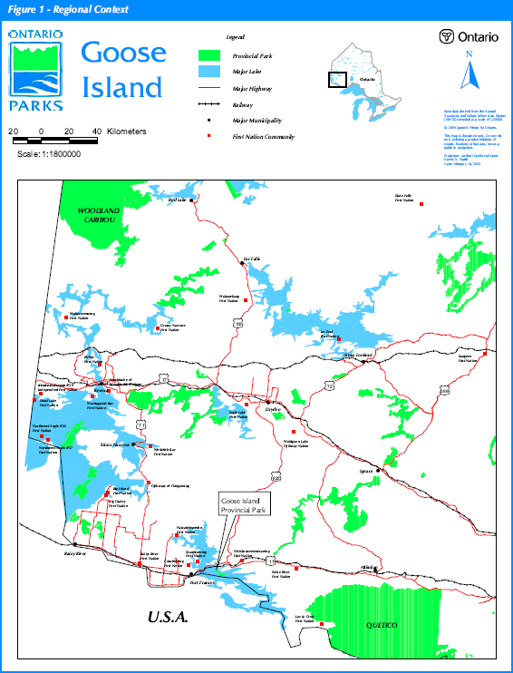
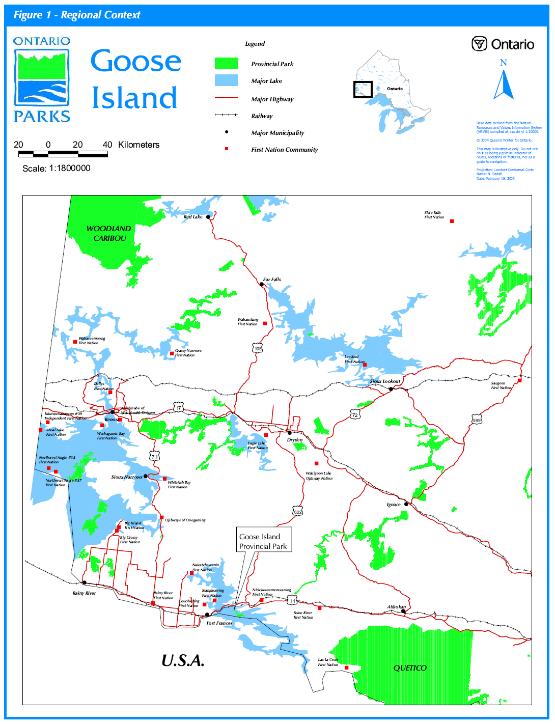
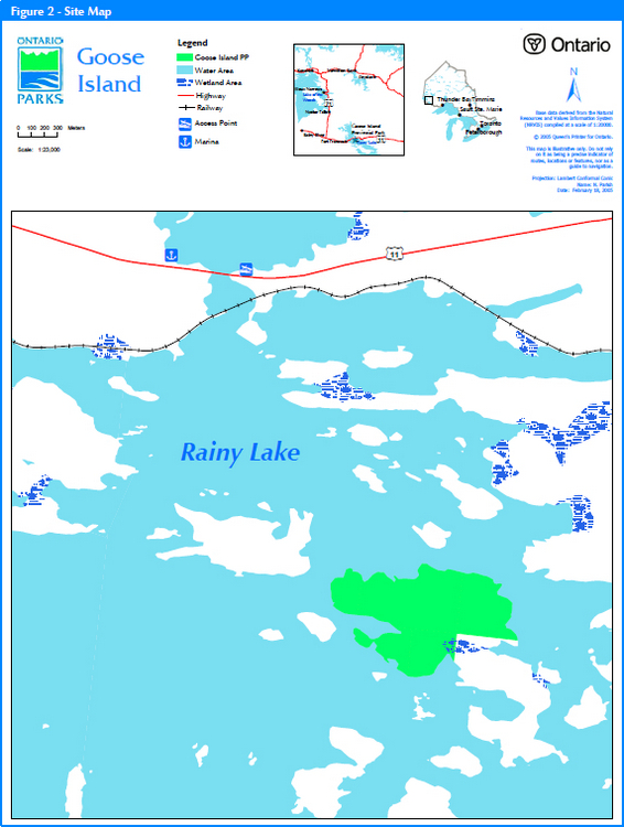
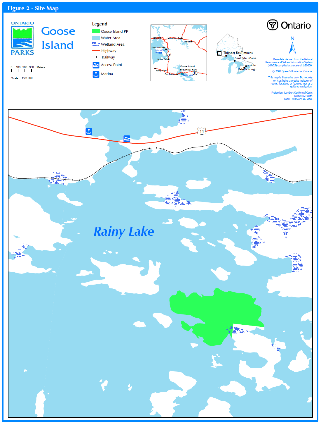
Goose Island is located in Rainy Lake in northwestern Ontario. The portion of the 125-hectare island owned by the Nature Conservancy of Canada is 75.45 hectares and extends only to the high water mark (Figure 2). This part will be managed as a Nature Reserve Class Provincial Park. The Goose Island property is a provincially significant ecological area due to its biological diversity, special beauty, and educational and scientific interest. The park is located approximately 12 kilometres northeast of Fort Frances on Rainy Lake (Figure 1).
When the Goose Island property was put up for sale in the late 1990s, local cottagers became concerned that the quality of life on the lake would be negatively affected by increased traffic, noise and environmental impacts should a plan of subdivision and cottage development occur. In addition, this kind of development could encourage other private island owners to subdivide their land.
This group of concerned cottagers raised the money to purchase the Goose Island property in partnership with The Nature Conservancy (TNC) (US). The TNC purchased Goose Island and transferred it to the Nature Conservancy of Canada (NCC). The NCC and Ontario Parks agreed to undertake a joint initiative, the Ontario Parks Legacy 2000 Program, aimed at acquiring private lands to create new Provincial Nature Reserves and other parklands to further mutual objectives and celebrate the millennium. In May 1999, the cottagers formed the Rainy Lake Conservancy as an ongoing commitment to conservation on Rainy Lake. In 2000, the NCC signed a lease agreement with MNR to administer, protect and manage the Goose Island property as part of the parks and protected areas system. The Rainy Lake Conservancy will continue to be involved in the protection and management of this property for conservation purposes and for the benefit of the people of Ontario.
II Aboriginal interests
There are no land claims regarding Goose Island at this time. The First Nations in this Treaty 3 Area of Rainy River are Couchiching, Stanjikoming and Nicickousemenecaning. These three First Nations are known as Pwi-d-goo-zing-ne-yaa-zhing (The Fort Frances Area Tribal Council).
Guideline:
Any management guidelines will reflect the Ontario government’s approach to aboriginal rights.
All decisions related to the identification, planning or disposition of provincial parklands or other lands set aside to protect significant natural or cultural heritage values, will be the subject of public consultation. Aboriginal peoples who identify traditional ties to those lands will be integral to the consultation decision-making processes. In some cases there may be need for separate consultation or negotiation processes to address Aboriginal interest in parklands. If required, some issues regarding how this land is managed, may also be the subjects of negotiation with Aboriginal people.
The Government of Ontario will consider all the available options when seeking to determine the land component, if any, during negotiations involving land claim settlements with First Nations. Options for uses which involve lands that are not to be considered for provincial park purposes will be preferred.
As described in the Province’s Interim Enforcement Policy (1991), aboriginal people hunting or fishing in provincial parks will be subject to all relevant treaties and laws. However, an agreement reached between the Province and a First Nation may modify the application of those treaties and laws. (Ontario Provincial Parks: Planning and Management Polices 1992)
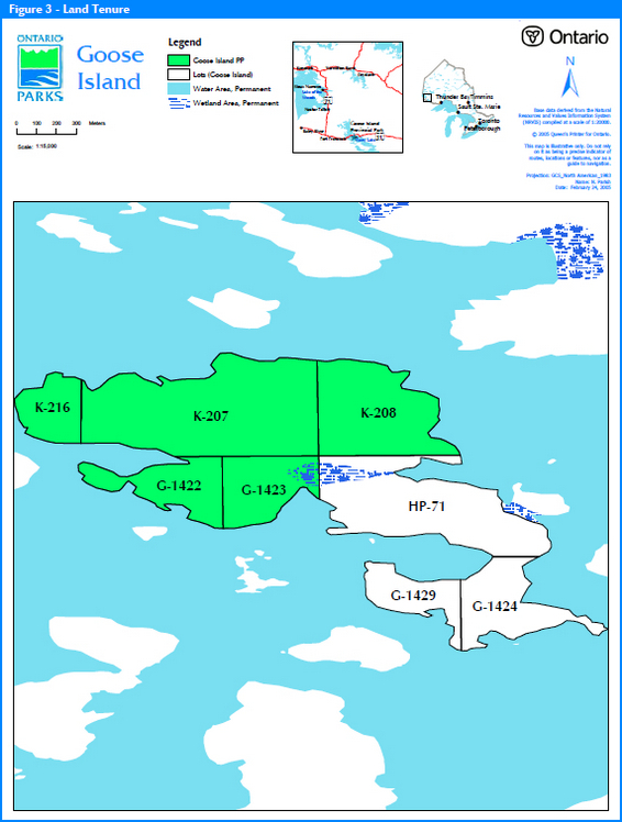
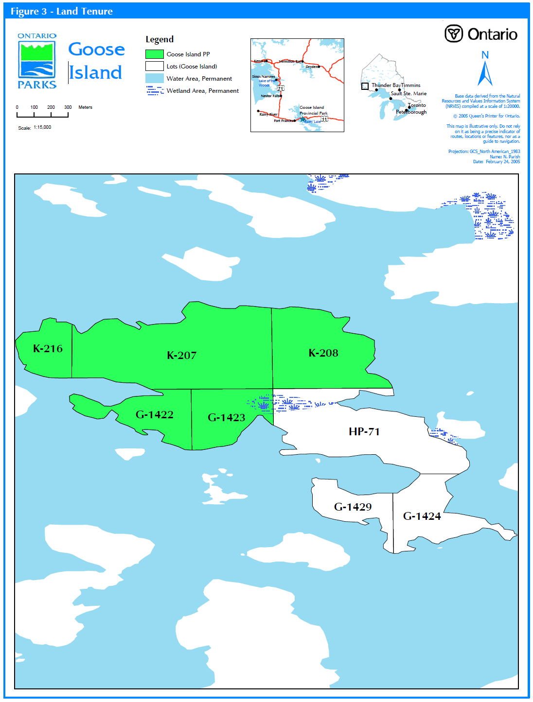
III Land tenure/acquisition/dispositon
The north two-thirds of the island is owned by the Nature Conservancy of Canada (Locations K-208, G-1422, G-1423, K-216 and K-207). The existing Lease Agreement directs Ontario Parks to protect and manage the Goose Island property in accordance with the policies of provincial nature reserves within the parks and protected areas system.
The remaining one third, (Locations G1424, Hp 71 and G1429) is presently owned by Mr. Theodore Hamm.
Guideline:
- No land disposition for the private use of individuals or corporations will be considered within the park
- If any portions of the adjacent patent land become available, they will be considered for an addition to the park on a willing-seller-willing-buyer basis pending the park management plan
IV Natural resource stewardship
Goose Island is located in the Lake Wabigoon Site Region (Ecoregion 4S) and represents the characteristic ecosystem and landform features of Ecodistrict 4S-6.
Due to a lack of detailed geological information for Goose Island, a comprehensive representation analysis of the contribution of the site’s landform-vegetation (LV) types towards benchmarks for Ecodistrict 4S-6 are not available.
Earth science
The island terrain is gentle Precambrian, typical of the area with the highest point being a cliff on the southwest corner. Outcrops of granitic composition are present along the shoreline. Goose Island lies within the Fort Frances-Mine Center greenstone belt, which is part of the Wabigoon Subprovince. The rocks on and around the site are all Precambrian in age at around 2.7 billion years. The site is completely underlain by amphibolite-grade metamorphosed sedimentary rocks (wacke and mudstones) as represented by biotite schist. The surficial geology of the area developed during the Cenozoic Era (last glacial period occurred approximately 10,000 years ago). Bedrock terrain best describes the site; relief varies from 0 to 30 metres with very little glacial deposits. The shoreline is primarily bedrock or fractured rock with some boulder/cobble areas.
Lands and waters
The island is located on Rainy Lake which is a major lake within the Winnipeg River Drainage Basin. This boundary lake between Ontario and Minnesota is 92,100 hectares (75% in Ontario) with 1,600 islands and 1,495 kilometers of shoreline. The lake is comprised of three main basins, the North Arm, the South Arm and Red Gut Bay. Rainy Lake is a warm water lake with a mean depth of 9.8 metres and a maximum depth of 49.1 metres.
Guideline:
- Mineral exploration or development is not permitted
- Aggregate extraction is not permitted
- Commercial hydro development, including solar and wind power, is not permitted
Life science
Although the relatively small natural Life Science areas found on Goose Island may not substantially alter the degree of representation within Ecodistrict 4S-6, its designation as a provincial park will certainly contribute towards the protection of local biodiversity. Goose Island contains high-quality areas of conifer, mixedwood, and hardwood-dominated upland forest habitat, as well as a marsh area that provides refuge for many bird species in a region becoming increasingly settled. Conservation of this habitat area will increase the connectivity of the regional landscape and allow species (particularly birds) to move more easily between larger protected areas.
Because neighbouring land uses can have severe impacts on natural features of adjacent parks, it is fortunate that Goose Island is adjacent to other islands that comprise the proposed Rainy Lake Islands Conservation Reserve. Thus it is well-positioned to function as a key component of the local protected areas network.
Vegetation management
As is typical of Ecoregion 4S, both Boreal and Great Lakes-St. Lawrence species are well-represented in high-quality areas of pine, mixedwood, and hardwood forest types, bedrock outcrops, and marsh/wetland habitats. Forest vegetation is characterized by uneven-aged stands of Red Pine, White Pine and Jack Pine on the drier, thin soiled, rocky upland sites, with White Spruce and Balsam Fir in the understory. Common boreal hardwoods in this transitional forest area include Paper Birch, Green and Speckled Alder, Northern Pin Oak, Trembling Aspen, and some Red and Sugar Maple in warmer areas. One field investigation revealed four types of mixedwood forest across the island, two of which were dominated by hardwood species, and two dominated by conifer species. Forested areas are also typically rich in shrubs (e.g., Acer spicatum, Sorbus decora, Diervilla lonicera, Linnea borealis, Vaccinium angustifolium) and herbs (Clintonia borealis, Cornus canadensis, Maianthemum canadense, Trientalis borealis). In addition, Goose Island contains approximately 10.5 ha of varied regionally significant wetland areas, including some shoreline wetlands and inland marshes.
Recent fieldwork revealed five vegetation types, five different ecosite types, and a wide range of soils within this small park area. A significant Black Ash stand is present, and the provincially rare Northern Pin Oak also occurs on Goose Island; this species occurs more often further west on Lake Superior shorelines and on Rainy Lake, and is not widespread in northern boreal forests. Approximately 117 vascular plant species have been recorded at Goose Island, from all sources, and considerable diversity potential exists for additional species, given the variety of vegetation types present such as upland forests, swampy forests, and wetlands.
Fire appears to have caused little change to vegetation, and there is no documented forest fire history on the island, which is in the intensive protection zone for wildfire suppression.
Guideline:
- Commercial forest operations are not permitted
- Fuelwood cutting is not permitted
- In the absence of a fire management plan, fire management objectives for the surrounding fire zone will apply
- Management will be directed toward ongoing natural succession. Vegetation management may be considered through planning
- Insect/disease suppression of non-native species is permitted
- Commercial wild rice harvesting does not occur. New operations will not be permitted
Fish & wildlife management
Fieldwork on Goose Island in 2001 revealed 14 birds, 4 mammals, 4 amphibians, 2 reptiles and 1 butterfly, although these should not be considered exhaustive species lists as accurate observation data remains scarce for most taxonomic groups, because of time constraints and logistics. Deer, moose and bear use the island habitat although they are thought to be transient species. Active beaver lodges are present along the shoreline.
The 14 bird species identified during the field visit are typical of the transition zone between the Great Lakes St. Lawrence and Boreal Forests. Goose Island provides important habitat for the provincially endangered Bald Eagle, which is currently found in only a fraction of its original range across the province. Cope’s Gray Treefrog has been reported at Goose Island and this rare species is officially recognized as occurring only in the Rainy River region in Ontario.
Common sport fish species in Rainy Lake include walleye, northern pike, perch and bass. Intense sportfishing is concentrated around a number of active and flourishing tourist operations and fishing lodges operating in the region.
There is a registered non-aboriginal trapline on Goose Island -- FF-04N028. The island is also located in Bear Management Area (BMA) FF-11A-02 and Bait Harvest Agreement Area FF0038.
Guideline:
- Non-invasive wildlife monitoring may be encouraged.
- Wildlife management may be encouraged pending park management planning.
- Sport fishing along the shoreline is permitted subject to the Ontario Sport Fishing Regulations
- Commercial bait harvesting is not permitted and will be phased out by December 31, 2009
- Sport hunting is not permitted. The park area will be removed from BMA #FF11A-02 as soon as possible
- Commercial trapping is not permitted. This activity will be phased out by December 31, 2009 except for trapping by Status Indians exercising Treaty rights
V Cultural resources
There is an old stone chimney that still stands on the northwest corner of the island within the park. It was apparently part of an old mining cabin; however, there is no documented record
Guideline:
- Further inventory is required to assess the cultural resources of Goose Island Provincial Park as funds become available
- The locations of any archaeological sites will not be public information. Necessary measures (access/development restrictions) to protect the integrity of any archaeological sites will be implemented
- The need for a Cultural Resources Plan/Strategy to protect the integrity of cultural features/sensitive areas will be determined with park management planning
VI Existing development
There is presently no development on Goose Island or the adjacent patent land.
Guideline:
- Park management planning will determine policies for recreational management, including trails and observation blinds
- No roads will be permitted
VII Recreation activities
Goose Island Provincial Park has limited potential for high intensity, structured recreational activities. There are a few minor trails used by blueberry pickers. Hiking, viewing and nature appreciation are possible future recreational pursuits. Boating and angling are popular activities in the area now, although they are not possible in the park.
Guideline:
- Low intensity day use activities such as blueberry picking, picnicking, wildlife viewing, nature appreciation, painting and photography are all activities which enhance appreciation of the park and will be permitted
- The use of motorized vehicles is not permitted
- Overnight camping is not permitted
- Overnight mooring of boats is not permitted
VIII Access
Goose Island is accessible by water from either Hudson’s Marina or Windy Point Public Access (Figure 2). Both are located north of Hwy. 11, approximately three kilometres from Goose Island.
Guideline:
- Access zones within the park, and any facilities required to support access, will be determined through park management planning
IX Client services
There are currently no client services for Goose Island Park.
Guideline:
- Client services will be limited to a map/brochure until an approved park management plan is complete
X Research and inventories
Life science and earth science reconnaissance inventories were completed in August 2001. A
detailed life science inventory was completed in 2004.
Guideline:
- Detailed cultural and recreational value inventories will be undertaken when funding permits
- Additional research/inventories to document park values will be permitted if not in conflict with park values and consistent with Ontario Parks research and Information Strategy
- OMNR, Ontario Parks or partnered groups and individuals may undertake research projects The Zone Manager must approve all research applications.
XI Marketing
Goose Island Provincial Park will not be actively marketed as the primary goal is to protect park values.
Guideline:
- For any type of publicity, the parties of Ontario Parks and the Nature Conservancy Canada shall give each other notice according to the lease agreement
- The public will be notified regarding regulation of the Goose Island property under the Provincial Parks Act
- A park management plan may direct that a Marketing Plan be developed.
XII Sources/references
Crins, W.J., and P. Gray. 2001. The ecozones and ecoregions of Ontario. Draft manuscript.
Page, R., L. Ng, S.R. Kingston and G. Lipsett-Moore, 2004. Goose Island: Detailed life science report. Ontario Ministry of Natural Resources, Northwest Zone of Ontario Parks.
Ontario Ministry of Natural Resources, Ontario Provincial Parks Planning and Management Policies, 1992 Update
Roed, MA. 1980: Rainy Lake area (NTS 52C/NW), District Rainy River; Ontario Geological Survey, Northern Ontario Engineering Geology Terrain Study 53, 14p.Accomapnied by Map 5069, scale 1:100000. Area Geologists Peter Hinz and Allan Roaual
Poulsen, K.H. 2000. Archean metallogeny of the Mine Centre-Fort-Frances area; Ontario Geological Survey, Report 266, 121p.
Lease Agreement re Goose Island Property, Between The Nature Conservancy of Canada and Her Majesty the Queen (represented by the Minister of Natural Resources). January 26, 2000.
Appendix A
Land use activity
Goose Island Provincial Park
Commercial activities
| Activity | Permitted | Guideline |
|---|---|---|
| Aggregate Extraction | No | |
| Bait Fishing (commercial) Existing: | Yes | Existing use to be phased out no later than December 31, 2009. |
| Bait Fishing (commercial) New: | No | |
| Commercial Fishing Existing: | No | No activity exists. |
| Commercial Fishing New: | No | No activity exists. |
| Commercial Fur Harvesting Existing: | Yes | Existing use to be phased out no later than December 31, 2009, except for Status Indians exercising Treaty rights. |
| Commercial Fur Harvesting New: | No | |
| Commercial Hydro Development: | No | |
| Commercial Timber Harvest: | No | |
| Commercial Tourism (e.g. outfitting services, outpost camps, resorts/lodges) Existing: |
No | No activity exists. |
| Commercial Tourism (e.g. outfitting services, outpost camps, resorts/lodges) New |
No | |
| Bear Hunting by Non-residents (guided): | No | Hunting is not permitted. |
| Energy Transmission and Communications Corridors (new): |
No | |
| Mineral Exploration and Development: | No | |
| Wildrice Harvesting - existing | No | No activity exists. |
| Wildrice Harvesting - New: | No |
Land and resource management activities
| Activity | Permitted | Guideline |
|---|---|---|
| Crown Land Disposition (new) - Private Use: | No | No tenure has been issued by the Crown for private use. |
| Crown Land Disposition (new) - Commercial Use | No | |
| Fire Suppression: | Maybe | In the absence of a fire management plan, fire management objectives for the surrounding fire zone will apply. |
| Fish Habitat Management: | No | There are no inland lakes in the park. |
| Fish Stocking Native Species: | No | There are no inland lakes in the park. |
| Fish Stocking Non-native Species: | No | |
| Insect/Disease Supression | Maybe | Insect/disease suppression of non-native species is permitted. |
| Inventory/Monitoring: | Yes | |
| Prescribed Burning: | Maybe | May be considered through planning. |
| Roads (non-park use) Existing: | No | No road currently exist. |
| Roads (non-park use) New: | No | |
| Vegetation Management: | Maybe | May be considered through planning. |
| Water Control Structure Existing: | No | No structures exist. |
| Water Control Structure New: | No | |
| Wildlife Population Management: | Maybe | May be considered through planning. |
Science, education and heritage appreciation
| Activity | Permitted | Guideline |
|---|---|---|
| Demonstration Areas: | No | |
| Historical Appreciation (self-guided): | Maybe | Support facilities to be identified through planning. |
| Nature Appreciation(self-guided): | Maybe | Support facilities to be identified through planning. |
| Photography and Painting: | Yes | |
| Research: | Yes | Subject to authorization. |
| Wildlife Viewing: | Maybe | Support facilities to be identified through planning. |
Recreation activities and facilities
| Activity | Permitted | Guideline |
|---|---|---|
| Aircraft Landing (water): | No | The park contains no suitable waters. |
| All Terrain Vehicle Use On Trails: |
No | |
| All Terrain Vehicle Use Off Trails: |
No | |
| Camping: | No | |
| Horseback Riding (trail): | No | No trails exist. |
| Hunting: | No | |
| Mountain Bike Use: | No | |
| Motor Boat Use Commercial: |
No | The park contains no suitable waters. |
| Motor Boat Use Private: |
No | |
| Non-motorized Recreation Travel (canoeing, kayaking, hiking, cross-country, skiing, snowshoeing): | Maybe | Long-term direction will be determined through planning. |
| Private Recreation Camps (Hunt Camps) Existing: | No | No camps exist. |
| Private Recreation Camps (Hunt Camps) No: | No | |
| Rock Climbing: | ||
| Sailing and Sailboarding: | ||
| Scuba and Skin Diving: | ||
| Snowmobiling On Trails: | No | |
| Snowmobiling Off Trails: | No | |
| Sport Fishing | No | The park contains no suitable waters. |
| Trail development | Maybe | Long-term direction will be determined through planning. |
Figure 1: Regional Context
Enlarge Figure 1: Regional Context map
Figure 2: Site Map
Figure 3: Land Tenure