Greenbelt maps
Learn about the boundaries of the Greenbelt and how the natural systems of the Protected Countryside, Urban River Valley areas, Oak Ridges Moraine and Niagara Escarpment are interconnected.
Overview
The Greenbelt was established in 2005. It includes over 800,000 hectares of land and extends 325 km from the eastern end of the Oak Ridges Moraine, near Rice Lake, in the east, to the Niagara River in the west.
The Greenbelt Act, 2005 designates the Greenbelt Area referencing a series of maps. This area is governed by the Greenbelt Plan.
Current land use designation maps (2023)
The Greenbelt Plan applies to the lands designated in section 2 of the Greenbelt Act, 2005 as the Greenbelt Area.
The Greenbelt Area is shown on Schedules 1-4 and Appendices I-II of the Greenbelt Plan, which also show the land use designations, including the Protected Countryside and Urban River Valley areas.
- Schedule 1 (PDF) - The Greenbelt Area. This includes the Protected Countryside, Urban River Valleys, Niagara Escarpment Plan Area and Oak Ridges Moraine Area
- Schedule 2 (PDF) - Niagara Peninsula Tender Fruit and Grape Specialty Crop Area
- Schedule 3 (PDF) - Holland Marsh Specialty Crop Area
- Schedule 4 (PDF) - Natural Heritage System
- Appendix 1 (PDF) - Schematic showing natural system connections among the Protected Countryside, Niagara Escarpment and Oak Ridges Moraine
- Appendix 2 (PDF) - Schematic showing settlements within the Greenbelt Area
Current land use designations interactive map
Boundary regulation maps (2005–2022)
- The Protected Countryside (2005)
- Additions to the Protected Countryside (2022)
- Removals from the Protected Countryside (2022)
- Additions to the Urban River Valley areas (2022)
- Additions to the Protected Countryside (2017)
- Removals from the Protected Countryside (2017)
- Urban River Valley areas (2017)
- Glenorchy lands (2013)
The boundary of the Greenbelt Area is defined in section 2 of the Greenbelt Act, 2005.
This map series provides the information for establishing the Greenbelt boundary by a Licensed Ontario Land Surveyor, under instructions from the Surveyor General for the Province of Ontario including changes made in 2023. The following maps should be read in conjunction with section 2 of the Greenbelt Act, 2005.
The maps are digital representations of the official signed versions which are available through the Office of the Surveyor General and at the offices of the Ministry of Municipal Affairs and Housing.
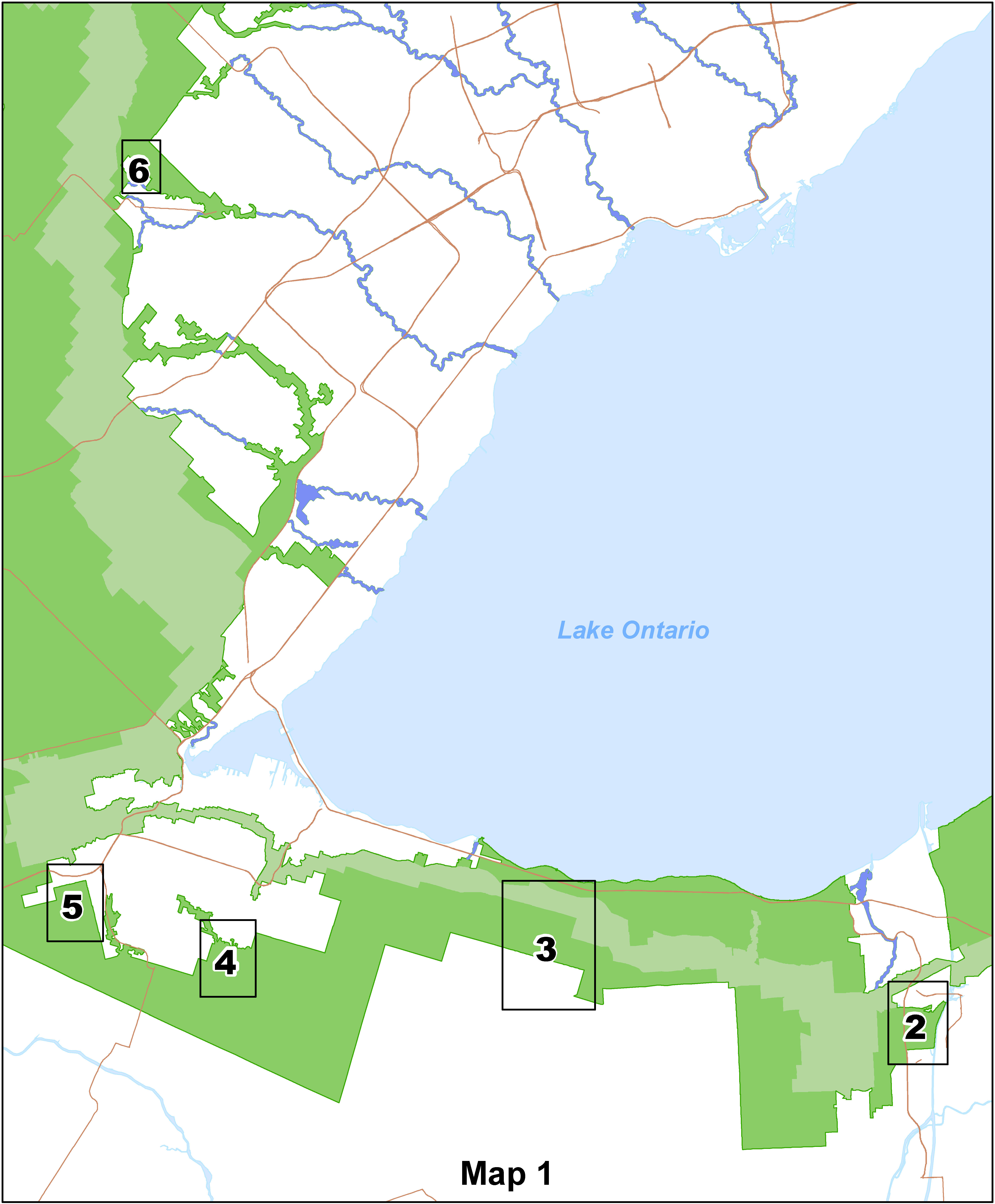
The Protected Countryside (2005)
These maps show the prescribed legal boundary of the Protected Countryside.
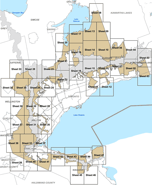
A key map detailing the Protected Countryside separated into 46 smaller areas.
The key map (Sheet 1) (PDF) shows the Plan of the Boundary of the Protected Countryside separated into 46 smaller geographic areas listed below:
- Sheet 2 (PDF) - Municipality of Clarington
- Sheet 3 (PDF) - Municipality of Clarington
- Sheet 4 (PDF) - City of Kawartha Lakes
- Sheet 5 (PDF) - Municipality of Clarington
- Sheet 6 (PDF) - Township of Scugog
- Sheet 7 (PDF) - Municipality of Clarington, City of Oshawa, Township of Scugog, and Town of Whitby
- Sheet 8 (PDF) - Township of Brock
- Sheet 9 (PDF) - County of Simcoe and Township of Brock
- Sheet 10 (PDF) - Township of Brock, Township of Scugog, and Township of Uxbridge
- Sheet 11 (PDF) - City of Pickering, Town of Whitby, Town of Ajax, City of Oshawa, and Township of Scugog
- Sheet 12 (PDF) - Town of Ajax and Town of Whitby
- Sheet 13 (PDF) - Township of Brock, Township of Uxbridge and Town of Georgina
- Sheet 14 (PDF) - Township of Brock, Township of Uxbridge, Township of Scugog, Town of Georgina, Town of East Gwillimbury and Town of Whitchurch-Stouffville
- Sheet 15 (PDF) - City of Pickering, City of Markham, and Town of Whitchurch-Stouffville
- Sheet 16 (PDF) - City of Pickering, City of Toronto, Town of Ajax, and City of Markham
- Sheet 17 (PDF) - Town of Georgina, Town of East Gwillimbury and Township of Uxbridge
- Sheet 18 (PDF) - Town of Whitchurch-Stouffville, Town of East Gwillimbury, Township of Uxbridge and Town of Georgina
- Sheet 19 (PDF) - City of Markham, Town of Richmond Hill, and Town of Whitchurch-Stouffville
- Sheet 20 (PDF) - Town of East Gwillimbury, Town of Georgina, Township of King, and Town of Innisfil
- Sheet 21 (PDF) - Township of King and Town of East Gwillimbury
- Sheet 22 (PDF) - Township of King
- Sheet 23 (PDF) - Town of Caledon and Township of King
- Sheet 24 (PDF) - City of Brampton, Town of Caledon, Township of King and City of Vaughan
- Sheet 25 (PDF) - City of Brampton, Town of Halton Hills, Town of Milton, and Town of Caledon
- Sheet 26 (PDF) - City of Burlington, Town of Halton Hills, Town of Milton and City of Oakville
- Sheet 27 (PDF) - City of Hamilton and City of Burlington
- Sheet 28 (PDF) - Town of Mono and Town of Caledon
- Sheet 29 (PDF) - Town of Caledon and Town of Erin
- Sheet 30 (PDF) - Town of Halton Hills, Town of Milton, City of Brampton, Town of Caledon, and Township of Erin
- Sheet 31 (PDF) - City of Hamilton, City of Burlington, Town of Halton Hills, Town of Milton and Township of Puslinch
- Sheet 32 (PDF) - City of Hamilton
- Sheet 33 (PDF) - Township of East Garafraxa, Town of Mono, Town of Orangeville, and Town of Caledon
- Sheet 34 (PDF) - Township of East Garafraxa and Town of Erin
- Sheet 35 (PDF) - Town of Erin, Township of East Garafraxa, Town of Caledon and Town of Orangeville
- Sheet 36 (PDF) - Town of Milton, Town of Erin and Town of Halton Hills
- Sheet 37 (PDF) - City of Hamilton, Town of Milton, and Township of Puslinch
- Sheet 38 (PDF) - City of Hamilton and Township of North Dumfries
- Sheet 39 (PDF) - City of Hamilton
- Sheet 40 (PDF) - City of Hamilton
- Sheet 41 (PDF) - City of Hamilton
- Sheet 42 (PDF) - Town of Grimsby
- Sheet 43 (PDF) - Town of Pelham and Town of Lincoln
- Sheet 44 (PDF) - Town of Pelham, City of Thorold, City of St Catharines, and Town of Lincoln
- Sheet 45 (PDF) - Town of Pelham
- Sheet 46 (PDF) - City of Thorold and Town of Pelham
- Sheet 47 (PDF) - City of St Catharines and City of Thorold
- Sheets 48-57 (PDF) - UTM coordinates required for surveying the Plan of the Boundary of the Protected Countryside
Additions to the Protected Countryside (2022)
These maps show the prescribed legal boundary of additions to the Protected Countryside in 2022.
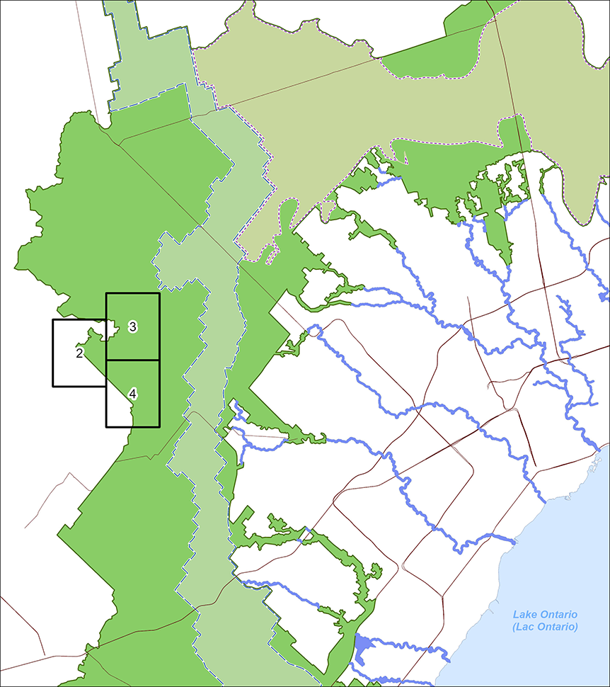
A key map detailing additions to the Protected Countryside separated into three smaller areas.
Sheet 1 (PDF) shows a key map detailing additions to the Protected Countryside separated into three smaller areas listed below:
- Sheet 2 (PDF) - Lands in the Paris Galt Moraine, Town of Erin (west)
- Sheet 3 (PDF) - Lands in the Paris Galt Moraine, Town of Erin (north-east)
- Sheet 4 (PDF) - Lands in the Paris Galt Moraine, Town of Erin (south-east)
Removals from the Protected Countryside (2022)
These maps show the prescribed legal boundary of removals from the Protected Countryside in 2022. Note that all of these lands were returned to the Protected Countryside of the Greenbelt Area through the changes made to the Greenbelt Act, 2005 on December 6, 2023.
A key map detailing removals to the Protected Countryside separated into 15 smaller areas.
Sheet 1 (PDF) shows a key map detailing removals from the Protected Countryside separated into 15 smaller areas listed below:
- Sheet 2 (PDF) - Land located in the Township of King east of Dufferin Street, south of Miller’s Sideroad and west of Bathurst Street
- Sheet 3 (PDF) - Land located in City of Vaughan north and east of Teston Road and Pine Valley Drive
- Sheet 4 (PDF) - Land located in City of Richmond Hill east of Leslie Street, north of Elgin Mills Road East, west of Highway 404
- Sheet 5 (PDF) - Land located in the Town of Whitchurch-Stouffville at 11861 and 12045 McCowan Road and land located in City of Markham at 5474 19th Ave. at the northeast corner of 19th Ave. and McCowan Road
- Sheet 6 (PDF) - Land located in the City of Markham at 10379 Kennedy Road
- Sheet 7 (PDF) - Land located in City of Markham at 10235, 10378 and 10541 Hwy 48
- Sheet 8 (PDF) - Land located in the City of Pickering south of Highway 407, west of West Duffins Creek and north of the CP Belleville rail line
- Sheet 9 (PDF) - Land located in the City of Pickering south of Highway 407, west of West Duffins Creek and north of the CP Belleville rail line
- Sheet 10 (PDF) - Land located in the City of Pickering south of Highway 407, west of West Duffins Creek and north of the CP Belleville rail line
- Sheet 11 (PDF) - Land located in the City of Pickering south of Highway 407, west of West Duffins Creek and north of the CP Belleville rail line
- Sheet 12 (PDF) - Land located in Town of Ajax located at 765 and 775 Kingston Road East
- Sheet 13 (PDF) - Land located in Clarington at the northeast corner of Nash Road and Hancock Road
- Sheet 14 (PDF) - Land located in the City of Hamilton south of Garner Road West, west of Fiddlers Green Road, east of Shaver Road in the vicinity of Book Road
- Sheet 15 (PDF) - Land located in the City of Hamilton south of White Church Road East, west of Ferris Road, north of Chippewa Road East, east of Upper James Street
- Sheet 16 (PDF) - Land in the Town of Grimsby south of the GO rail line, west of Oakes Road North, north of Main Street West, east of Kelson Ave North and Land, located in the City of Hamilton at 331 and 339 Fifty Road
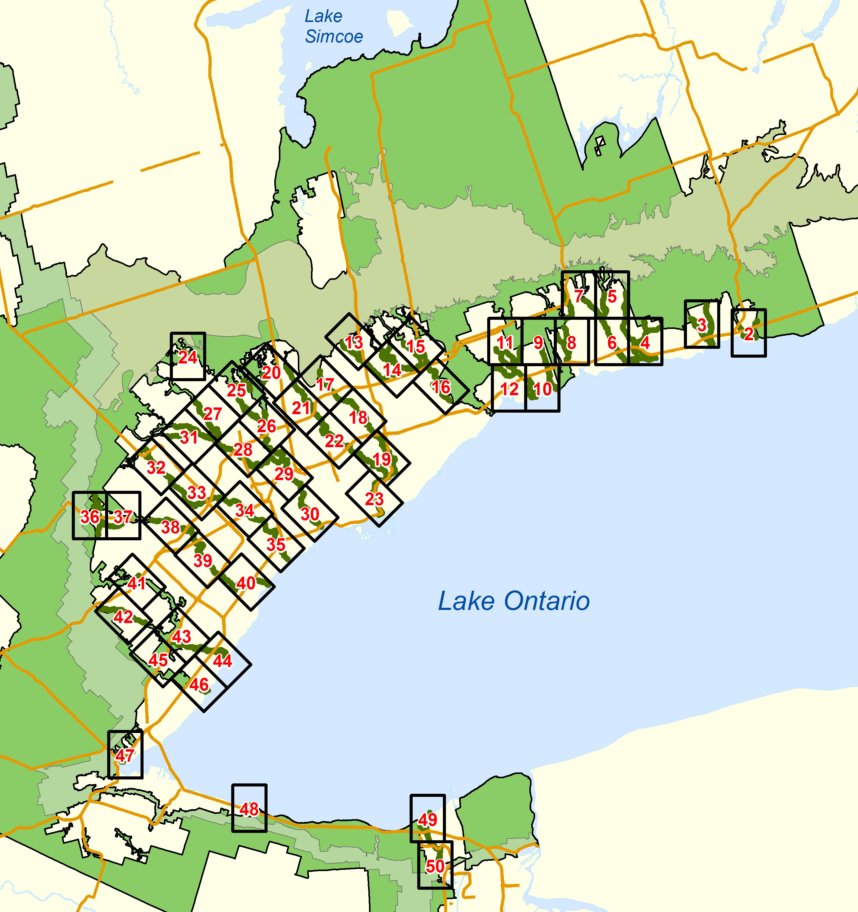
Additions to the Urban River Valley areas (2022)
These maps show the prescribed legal boundary of additions to the Urban River Valley areas in 2022.
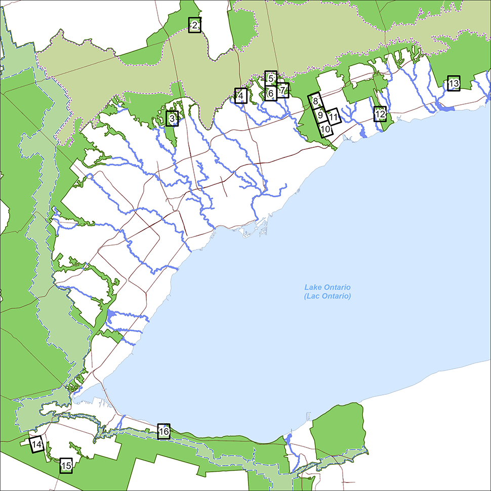
A key map detailing additions to the Urban River Valley areas separated into 12 smaller areas.
Sheet 1 (PDF) shows a key map detailing additions to the Urban River Valley areas separated into 12 smaller areas listed below:
- Sheet 2 (PDF) - Stoney Creek and Battlefield Creek in the City of Hamilton
- Sheet 3 (PDF) - Extension of Fourteen Mile Creek in the Town of Oakville
- Sheet 4 (PDF) - Humber Creek in the City of Toronto
- Sheet 5 (PDF) - Black Creek in the City of Toronto
- Sheet 6 (PDF) - Black Creek in the City of Toronto
- Sheet 7 (PDF) - Wilket Creek and Burke Brook in the City of Toronto
- Sheet 8 (PDF) - Burke Brook, Wilket Creek, and Taylor/Massey Creek in the City of Toronto
- Sheet 9 (PDF) - Taylor Creek in the City of Toronto
- Sheet 10 (PDF) - Extension of Oshawa Creek in the City of Oshawa
- Sheet 11 (PDF) - Darlington Provincial Park in the City of Oshawa and the Municipality of Clarington
- Sheet 12 (PDF) - Westside Marsh and area in the Municipality of Clarington
- Sheet 13 (PDF) - Wilmot Creek additional wetlands in the Municipality of Clarington
Additions to the Protected Countryside (2017)
These maps show the prescribed legal boundary of additions to the Protected Countryside in 2017.
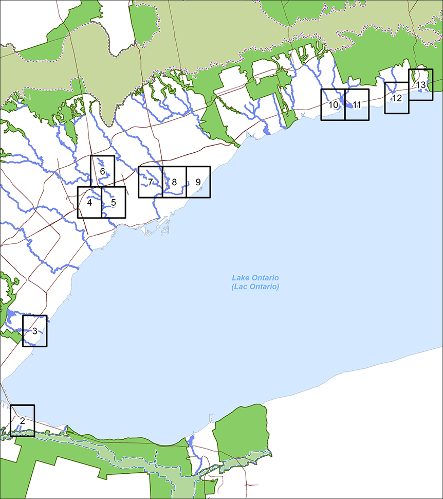
A key map detailing additions to the Protected Countryside separated into 5 smaller areas.
Sheet 1 (PDF) shows a key map detailing additions to the Protected Countryside separated into 5 smaller areas listed below:
- Sheet 2 (PDF) - Lake Gibson in the City of Thorold in Niagara Region
- Sheet 3 (PDF) - Town of Grimsby in Niagara Region
- Sheet 4 (PDF) - Nebo Road in the City of Hamilton
- Sheet 5 (PDF) - Book Road in the City of Hamilton
- Sheet 6 (PDF) - area next to the Glen Williams Hamlet in the Town of Halton Hills
Removals from the Protected Countryside (2017)
These maps show the prescribed legal boundary of removals from the Protected Countryside in 2017.
A key map detailing removals to the Protected Countryside separated into 16 smaller areas.
Sheet 1 (PDF) shows a key map detailing removals from the Protected Countryside separated into 16 smaller areas listed below:
- Sheet 2 (PDF) - Bowmanville in the Municipality of Clarington near Nash Road and Regional Rd. 57, containing the intersection of Nash Road and Green Road
- Sheet 3 (PDF) - City of Oshawa to the northwest of Winchester Road East and Ritson Road North (part of 2770 and 2830 Ritson Road North)
- Sheet 4 (PDF) - Town of Whitby to the southwest of Winchester Road West and Ashburn Road (5200 Ashburn Road, part of 5640 Ashburn Road, and part of 555 Winchester Road West)
- Sheet 5 (PDF) - City of Pickering on the east side of the Rouge Park
- Sheet 6 (PDF) - City of Pickering on the east side of the Rouge Park
- Sheet 7 (PDF) - City of Markham to the southeast of Major MacKenzie Drive East and Donald Cousens Parkway
- Sheet 8 (PDF) - City of Markham to the northwest of Major Mackenzie Drive East and Kennedy Road (part of 1006 Kennedy Road)
- Sheet 9 (PDF) - City of Markham at the northeast corner of 19th Avenue and Highway 404 (part of 2780 19th Avenue)
- Sheet 10 (PDF) - Town of East Gwillimbury to the southwest of Queensville Sideroad (part of 641 Queensville Sideroad East)
- Sheet 11 (PDF) - City of Vaughan to the northeast of Teston Road and Jane Street (part of 2700 Teston Road)
- Sheet 12 (PDF) - City of Vaughan to the southeast of Kirby Road and Highway 27 (part of 11191 Highway 27)
- Sheet 13 (PDF) - City of Vaughan near Highway 27 and Nashville Road (Kleinburg-Nashville Area)
- Sheet 14 (PDF) - Greenbelt Area associated with the Glen Williams Hamlet boundary adjustment in the Town of Halton Hills
- Sheet 15 (PDF) - City of Burlington located at 3270 Harrison Crescent
- Sheet 16 (PDF) - Greenbelt Area in Stoney Creek in the City of Hamilton south of Barton Street, near Glover Road
- Sheet 17 (PDF) - Greenbelt Area in Stoney Creek in the City of Hamilton northwest of Fifty Road and Barton Street
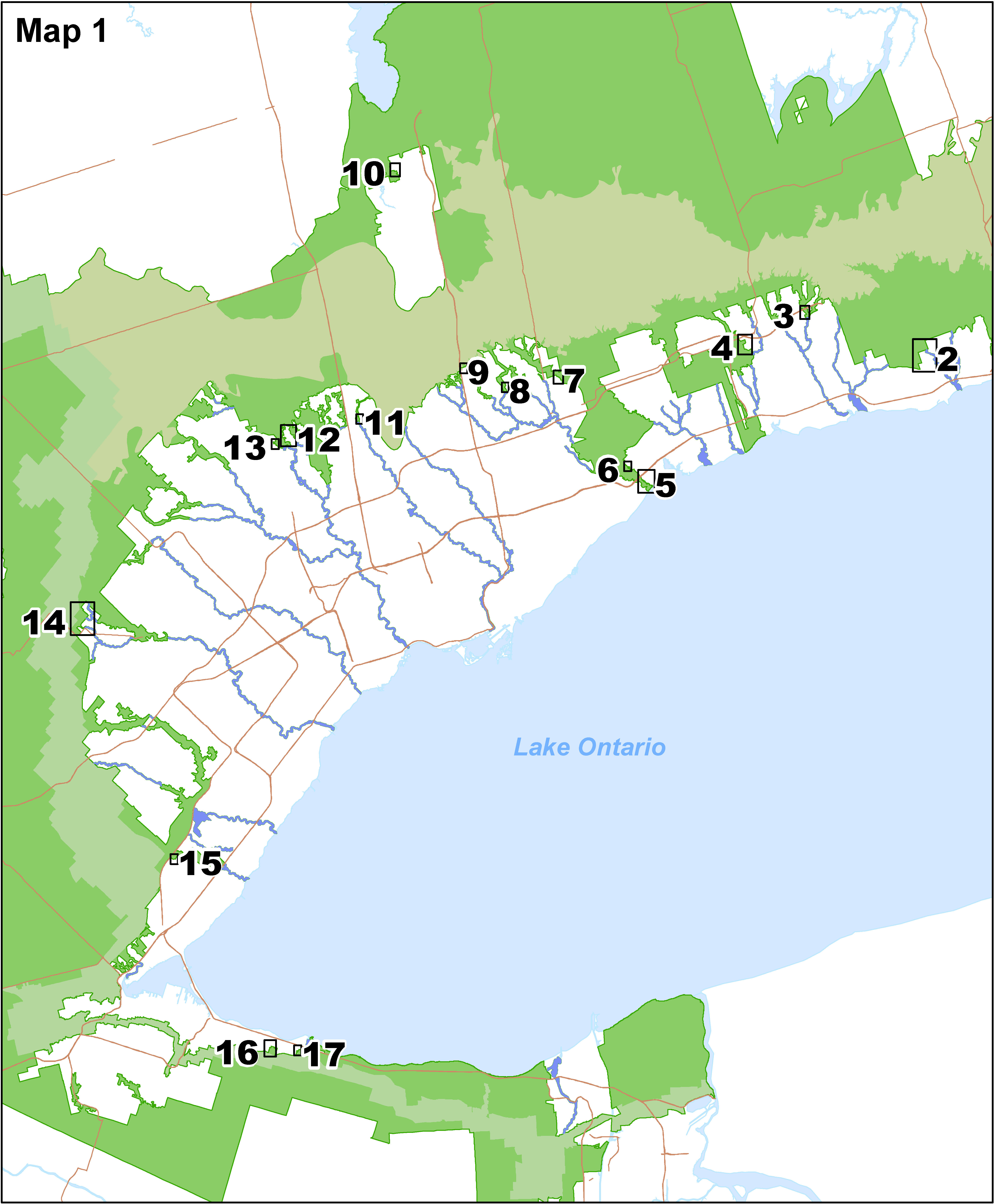
Urban River Valley areas (2017)
These maps show the prescribed legal boundary of Urban River Valley areas, added to the Greenbelt Area in 2017. The Greenbelt Plan’s policies only apply to publicly-owned lands in these areas.
A key map detailing the Urban River Valley areas separated into 49 smaller areas.
Sheet 1 (PDF) shows a key map detailing the Urban River Valley areas separated into 49 smaller areas listed below:
- Sheet 2 (PDF) - Graham Creek and Wilmot Creek in the Municipality of Clarington
- Sheet 3 (PDF) - Soper Creek and Bowmanville Creek in the Municipality of Clarington
- Sheet 4 (PDF) - Farewell Creek, Harmony Creek and Oshawa Creek in the Municipality of Clarington and the City of Oshawa
- Sheet 5 (PDF) - Harmony Creek and Oshawa Creek in the City of Oshawa
- Sheet 6 (PDF) - Harmony Creek and Oshawa Creek in the City of Oshawa
- Sheet 7 (PDF) - Oshawa Creek and Lynde Creek in the City of Oshawa and the Town of Whitby
- Sheet 8 (PDF) - Lynde Creek in the Town of Whitby
- Sheet 9 (PDF) - Boundary map showing portions of the Urban River Valley area along Carruthers Creek in the Town of Ajax
- Sheet 10 (PDF) - Carruthers Creek and Duffins Creek in the Town of Ajax and the City of Pickering
- Sheet 11 (PDF) - Duffins Creek in the City of Pickering
- Sheet 12 (PDF) - Duffins Creek in the Town of Ajax and the City of Pickering
- Sheet 13 (PDF) - Rouge River in the Town of Richmond Hill and the City of Markham
- Sheet 14 (PDF) - Rouge River in the City of Markham
- Sheet 15 (PDF) - Rouge River in the City of Markham
- Sheet 16 (PDF) - Morningside Creek and the Rouge River in the City of Toronto and the City of Markham
- Sheet 17 (PDF) - Don River in the City of Markham, the Town of Richmond Hill and the City of Vaughan
- Sheet 18 (PDF) - Don River in the City of Toronto, the City of Markham and the City of Vaughan
- Sheet 19 (PDF) - Don River in the City of Toronto
- Sheet 20 (PDF) - Don River and Humber River in the City of Vaughan
- Sheet 21 (PDF) - Don River in the City of Vaughan
- Sheet 22 (PDF) - Don River in the City of Toronto and the City of Vaughan
- Sheet 23 (PDF) - Don River in the City of Toronto
- Sheet 24 (PDF) - Humber River in the Town of Caledon
- Sheet 25 (PDF) - Humber River in the City of Vaughan
- Sheet 26 (PDF) - Humber River in the City of Vaughan and the City of Toronto
- Sheet 27 (PDF) - Humber River in the City of Brampton
- Sheet 28 (PDF) - Humber River in the City of Brampton and the City of Toronto
- Sheet 29 (PDF) - Humber River in the City of Toronto
- Sheet 30 (PDF) - Humber River in the City of Toronto
- Sheet 31 (PDF) - Humber River in the City of Brampton
- Sheet 32 (PDF) - Etobicoke Creek in the Town of Caledon and the City of Brampton
- Sheet 33 (PDF) - Etobicoke Creek in the City of Brampton and the City of Mississauga
- Sheet 34 (PDF) - Etobicoke Creek in the City of Mississauga and the City of Toronto
- Sheet 35 (PDF) - Etobicoke Creek in the City of Mississauga and the City of Toronto
- Sheet 36 (PDF) - Credit River in the Town of Halton Hills
- Sheet 37 (PDF) - Credit River in the Town of Halton Hills
- Sheet 38 (PDF) - Credit River in the City of Brampton and the City of Mississauga
- Sheet 39 (PDF) - Credit River in the City of Mississauga
- Sheet 40 (PDF) - Credit River in the City of Mississauga
- Sheet 41 (PDF) - Sixteen Mile Creek in the Town of Halton Hills
- Sheet 42 (PDF) - Sixteen Mile Creek in the Town of Milton
- Sheet 43 (PDF) - Sixteen Mile Creek in the Town of Oakville
- Sheet 44 (PDF) - Sixteen Mile Creek in the Town of Oakville
- Sheet 45 (PDF) - Fourteen Mile Creek in The Town of Oakville
- Sheet 46 (PDF) - Bronte Creek and Fourteen Mile Creek in the Town of Oakville
- Sheet 47 (PDF) - Grindstone Creek in the City of Burlington
- Sheet 48 (PDF) - Fifty Creek in the City of Hamilton and the Town of Grimsby
- Sheet 49 (PDF) - Twelve Mile Creek in the City of St. Catharines
- Sheet 50 (PDF) - Twelve Mile Creek in the City of St. Catharines
Glenorchy lands (2013)
This map (PDF) shows the prescribed legal boundary of the Glenorchy Lands in Oakville, added as an Urban River Valley area in 2013.
Greenbelt open data (2023)
Get GIS data of the Greenbelt land use designations and regulatory boundaries as described in section 2 of the Greenbelt Act, 2005:
- land use designations (2023)
- boundary regulations (2023)
Oak Ridges Moraine (2023)
See maps related to the Oak Ridges Moraine.
Niagara Escarpment area (MNRF)
The Niagara Escarpment Commission is responsible for administering the Niagara Escarpment Plan and a system of development control since the approval of the plan in 1985.
See maps of the Niagara Escarpment.
Active offer of assistance
If you require this information in an alternative format or need assistance using our interactive maps, please contact mininfo@ontario.ca. We will:
- acknowledge your request within three business days
- let you know when we are able to fulfil the request