Hammell Lake Conservation Reserve Management Statement
This document provides policy direction for the protection, development and management of the Hammell Lake Conservation Reserve and its resources.
Statement of Conservation Interest
Prepared For OMNR, Red Lake District
Joanne M. Stanley and Angie McLellan
OLL Interns
June 24, 2003
Approval statement
I am pleased to approve this Statement of Conservation Interest for the regulated Hammell Lake Conservation Reserve.
The Hammell Lake Statement of Conservation lnterest provides guidance for the management of the Conservation Reserve and the basis for the ongoing monitoring activities. Should significant facility development or resource management be considered, or complex issues arise requiring additional studies, a more detailed Conservation Reserve Management Plan will be prepared with full public consultation.
The public was widely consulted during the original regulation process for this site, and further consultation is not required at this time. Treaty 3 First Nation People’s and representatives of Lac Seul First Nation have been consulted with.
The Conservation Reserve will continue to be managed by the Red Lake North Area, Red Lake District, Ministry of Natural Resources.
Signed by:
Graeme Swanwick
District Manager
Red Lake District
Date: July 17, 2003
Signed by:
Charlie Lauer
Regional Director
Northwest Region
Date: July 22, 2003
Figure 1: Hammell Lake Conservation Reserve: Regional Setting
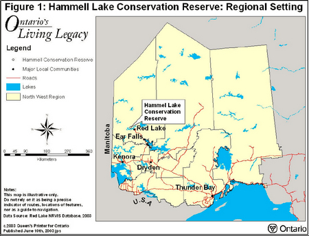
Enlarge Figure 1: Hammell Lake Conservation Reserve: Regional Setting
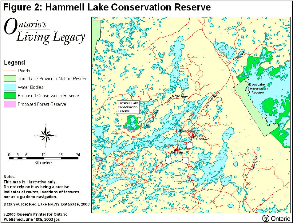
Figure 2: Hammell Lake Conservation Reserve
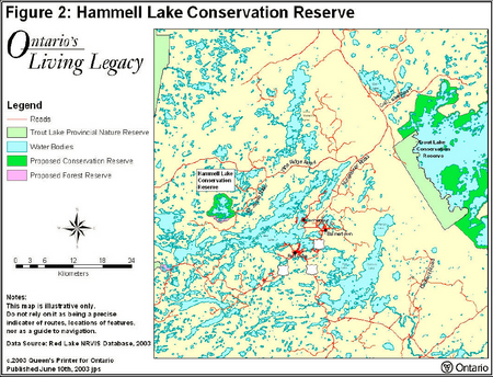
Enlarge: Figure 2: Hammell Lake Conservation Reserve
1.0 Background information
The purpose of this document is to identify the natural heritage values of the Hammell Lake Conservation Reserve, as well as identify the type and extent of current recreational use on-site. A set of management guidelines will define the activities that may or may not be permitted and the overall management direction for the area. For more information on a Statement of Conservation Interest, please refer to the Conservation Reserves Policy and Procedure PL3.03.05.
| Name | Hammell Lake Conservation Reserve |
|---|---|
| Site Region / Site District | 4S-2 |
| OMNR Administrative Region / District / Area |
Northwest Region – Red Lake District – Red Lake North Area |
| Total Area (ha) | 2,182 ha, with a 252 ha Forest Reserve |
| Regulation Date | December 7, 2002 |
| First Nations | Hammell Lake is within the traditional land use area of Lac Seul First Nation. Local First Nations Peoples living off Reserve in Red Lake have some interest in this area. However, no concern has been expressed regarding this site. |
| Latitude / Longitude | 51° 08' N / 94° 10' W |
| Basemap | 54565 and 54566 |
| Forest Resource Inventory Stand Numbers |
77, 117, 151, 164, 181, 370, 955, 958, 964 and others (2000 inventory) |
| General Location Description |
The Conservation Reserve is located approximately 20 km northwest of Red Lake in the Red Lake Forest Management Unit. |
| Access | To reach Hammell Lake Conservation Reserve from Highway 125, follow the Nungesser Road north. Turn west on Pine Ridge Road. Next turn south on Mount Jamie Mine Road. Mount Jamie Mine Road runs close to the south end of this Conservation Reserve. From this road a snowmobile trail runs approximately 3.25 km to the lakeshore. A summer portage also exists where the Mount Jamie Road intersects an unnamed lake east of Hammell Lake and west of Para Lake. The portage is approximately 400 m long from the northern end of the small lake to Hammell Lake. |
1.1 Targets
This section provides a summary of the earth science, life science and cultural resource values as well as any present or possible recreational opportunities.
| Life Science Representation | Representative boreal forest and wetland communities are found in the Hammell Lake Conservation Reserve. Fire regenerated Jack Pine and bedrock, shore fens, conifer swamps, aspen mixed woods, and beach communities are also present. Evidence from a 1986 burn is visible through much of the northwest boundary of the Conservation Reserve. Hammell Lake has been identified as a calving area for woodland caribou. |
|---|---|
| Earth Science Representation | There is greater than 50 % bedrock exposure found. Glacial features include roche moutonnees and glacial striac. Sand beaches are of recent origin. |
| Cultural Resource Representation | No documented cultural heritage values have been identified. |
| Recreational Opportunities | Remote wilderness recreation opportunities exist for both summer and winter seasons. Ice fishing is currently the predominant activity. Other recreational activities potentially include; exploring, hunting and nature study. |
1.2 Survey information
This section provides an overview of the completed inventories, their level of detail, and any further inventories that are needed.
| Survey Level | Reconnaissance | Detailed | Additional Survey Required |
|---|---|---|---|
| Life Science | Completed Autumn 2001 | No | |
| Earth Science | Completed Summer 2001 | No | |
| Cultural | No | No | |
| Recreational Check Sheet | Completed Summer 2001 | No |
2.0 Values to be protected
This section provides a description of the key natural heritage values on the Conservation Reserve site, their condition relative to past resource use, management activities and their sensitivity to future land use, and management activities.
2.1 Values identified on the site
| Life Science | Boreal forests and wetland areas comprise the Conservation Reserve. Lapland buttercup (northern affinity) and dragonhunter (near northern limit of its range) are the most notable flora and fauna observed. Caribou and wolverine habitat and use are documented for this area. |
|---|---|
| Earth Science | Glacial landforms; roche moutonees and glacial striac were observed. Extensive exposed bedrock and recent sand beaches are present. |
| Cultural | None Identified. |
| Aboriginal | Lac Seul First Nation Peoples, Treaty # 3. |
| Tourism | A commercial outpost existed from 1960-1985. The commercial operation was relocated to another Lake (in the interest of the sensitive Lake Trout fishery). |
| Recreational Fishing | Hammell Lake supports an active winter sport fishery for lake trout as well as providing some summer angling opportunities. The lake also contains walleye and northern pike. |
| Recreational Hunting | The Conservation Reserve may be used for moose and small game hunting (access from the Mount Jamie Mine Road). |
| Mining | There are several mining claims located in the south. These areas have been designated as a Forest Reserve. The claims will remain active until forfeited by the claimant. The Hammell Lake Conservation Reserve has been withdrawn from staking. |
| Aggregates | No past or existing operations. |
| Forest Harvest | The Conservation Reserve is part of the Red Lake Forest Management Unit; unallocated within the Forest Management Plan area and removed from the Sustainable Forest License. |
| Trapping | There are two registered traplines, RL60 and RL66 that are active and permitted to continue. |
| Bear Management Area | One active BMA runs through a small portion of the northern border. RL-02-15 is active and permitted to continue. |
| Commercial Fish | None. Other commercial fish species are present including lake whitefish. |
2.2 Values to be protected
The intent of this Statement of Conservation Interest is to protect values by establishing management guidelines for existing and potential uses in this area, given the level of past disturbance and the nature of the existing features.
Major Representative Values: The Hammell Lake Conservation Reserve provides critical representation of conifer on bedrock for Site 4S-2. The Conservation Reserve is also representative of ten other vegetation types on weakly to moderately broken bedrock. Islands within the Conservation Reserve serve as calving areas for vulnerable woodland caribou.
Forest Values: The Hammell Lake Conservation Reserve is located in the Red Lake Forest and has been withdrawn from the Sustainable Forest Licence (SFL). The forest located in the Conservation Reserve is to be protected from future harvest operations.
Forest Reserves (FR): A Forest Reserve containing active mining claims is located along the southern boundary of the Hammell Lake Conservation Reserve. Forest Reserves are areas where protection of natural heritage and special landscapes are a priority, however, some resource use can occur when managed sustainably. Access to existing claims will be permitted throughout the Conservation Reserve where negative impacts do not affect special features. A forfeited claim or lease in the Forest Reserve will resume to the Crown, be withdrawn from any future staking and added to the Conservation Reserve.
Recreational Values: The Hammell Lake Conservation Reserve offers limited access (i.e. roads, navigable waters). There is a trail leading to the shore from Mount Jamie Mine Road, which can be used by hunters or anglers. Popular sport fish are found in Hammell Lake and fishing is the most popular recreational use of this lake presently. Four private boat caches agreements are currently registered within the boundary of the Conservation Reserve. This lake is closed to new boat caches, and will remain closed. Existing boat cache agreements are also conditional to withdrawal if necessary for resource management purposes. There are no recreational development plans proposed or existing for this area.
Tourism Values: Sport fishing on this attractive, remote lake is an important day-use tourism value. Accessibility is limited, however, not completely restrictive. Use of tertiary roads, summer access trails and/or winter access trails provides accessibility. Over night camping by non-residents of Canada is prohibited.
3.0 Management guidelines
3.1 Land tenure
The Hammell Lake Conservation Reserve will remain Crown land. One private recreation camp is located on the south shore of Hammell Lake and is contained in the Conservation Reserve. No new dispositions for private use (including Land Use Permits or Licences of Occupation) will be issued in the Conservation Reserve. The existing land use permit is not transferable.
3.2 Existing and proposed development
To date there is no existing or proposed development within this Conservation Reserve. Development that would alter or disturb this site will not be permitted.
3.3 Recreational activities
Recreational activity is permitted, although access is restricted to two trails. Angling opportunities for sport fish do exist within the Hammell Lake Conservation Reserve, gaining access from Mount Jamie Mine Road, air or waterway. Hunting is permitted within the Conservation Reserve.
There are 4 private boat caches identified on Hammell Lake. Owners of these caches are permitted to continue usage within the Conservation Reserve boundaries, under their boat cache agreements.
3.4 Commercial activities
The Hammell Lake Conservation Reserve is within the boundaries of the Red Lake Forest Management Unit and has been permanently removed from the Sustainable Forest Licence held by the Red Lake Forest Company. An examination of the possible impact of their activities on adjacent lands should be evaluated through the forest management planning process.
The Ministry of Northern Development and Mines (MNDM) has withdrawn all mineral exploration and activities from this site.
There are two registered traplines located within the Conservation Reserve. RL60 and RL66 are active and permitted to continue.
The Hammell Lake Conservation Reserve has one active BMA running through a small portion of the northern border. RL-02-15 is active and permitted to continue.
Hammell Lake is located entirely within an active commercial baitfish block.
No other commercial activities exist in the area. New activities, such as mining, aggregate or peat extraction, commercial logging, hydroelectric power development, utility corridors, highways or roads, will not be permitted.
3.5 Aboriginal interests
Traditional land use in the Hammell Lake Conservation Reserve involves the Lac Seul First Nation. The Hammell Lake Statement of Conservation of Interest is not intended to affect Aboriginal rights and treaty rights.
3.6 Natural resource stewardship
3.6.1 Vegetation management
The Hammell Lake Conservation Reserve is part of the Red Lake Forest Management Unit and within the Boreal Zone of the West Fire Region. In 1986 a large fire occurred within the west, southwest portion of the Conservation Reserve. This area is continuing to regenerate back to a Jack Pine dominated forest.
Fire occurrences will be considered a high priority for action, however, in order to maintain the ecological integrity of this site, the role of fire must be considered. The Ministry of Natural Resources recognizes fire as an essential process in the maintenance and renewal of ecological sustainability and ecosystem health. Fire will occur naturally within the Conservation Reserve and fire and resource managers will need to identify the specific areas and conditions under which, prescribed and natural fires may be used to meet resource management objectives.
Prescribed burning will be used in accordance with Ministry of Natural Resources policies and guidelines to achieve resource management objectives within the Conservation Reserve. Flexibility in suppressing low-risk fire occurrences within the Hammell Lake Conservation Reserve will also be evaluated through a more detailed local natural resource management plan or fire management plan. Until a fire management plan is prepared all natural and prescribed fire will be dealt with according to the fire management objectives of the surrounding fire management zone.
3.6.2 Fish and wildlife management
The existing wildlife management unit, sport fishing regulations and their management activities will apply to facilitate the management of fish and wildlife in this Conservation Reserve.
The Hammell Lake Conservation Reserve shoreline and islands provide a summer refuge and calving habitat for woodland caribou. Through the forest management planning process this habitat value within and adjacent to the Conservation Reserve is identified and accommodated for. The Conservation Reserve is adjacent to suitable wintering habitat that is part of the woodland caribou habitat mosaic for the Red Lake Forest and referred to in the forest management plan as, Block C. This block currently sustains caribou populations on the southern edge of the caribou range. The management intent is to ensure a large tract of mature forest is always associated with the Hammell Lake Conservation Reserve. Block C is scheduled for harvest when the 1986 burn, which abuts the western shore of Hammell Lake, becomes mature forest (in approximately 40 yrs). The 1986 burn also separates winter use to the north in the Valhalla Lake area (outside the managed forest) and the calving habitat on Hammell Lake.
The Ministry of Natural Resources' intent is to maintain a north-south corridor through the 1986 burn to accommodate this movement of animals. Caribou have been documented using the burn for travel and it appears that the burn has sufficient height to provide cover. Wetlands within the burn also contribute toward the ease of travel through this area. The forest management planning process is key to maintaining caribou habitat and population linkages to the Hammell Lake area. Emulating fire occurrences through prescribed burning should also be considered for the management of woodland caribou. The development of even aged stands using prescribed burns, along with adjacent timber operations, will aid in maintaining high caribou habitat value for both the Conservation Reserve and adjoining landscape units.
Currently, summer recreational activities are not a threat to caribou use of the area, however, these activities will be monitored through routine enforcement efforts in this area.
3.6.3 Landforms
No management activity is required except protection.
3.7 Cultural resources stewardship
No management planning is required at this time based on existing information.
Cultural, historical and archaeological features were not identified when reviewing background information and research, nor were they identified during the site visit.
3.8 Client services
There are no established client services for this Conservation Reserve at this time, nor are there any immediate plans for developing such client services. Information on resources of this Conservation Reserve is available from the Red Lake District Office.
3.9 Research
Non-destructive research related to the study of earth and life sciences will be encouraged in this Conservation Reserve.
3.10 Marketing
No marketing activity is required at this time.
4.0 Implementation
Implementation of management guidelines is the responsibility of the Red Lake North Area Supervisor, Red Lake District. Any affected interest groups or clients will be immediately informed of proposed changes to this Statement of Conservation Interest.
5.0 Review and revisions
The Hammell Lake Conservation Reserve Statement of Conservation Interest will be reviewed on an ongoing basis.
If changes in management direction are needed at any time, the significance of the changes will be evaluated. The need for public notice or more formal consultation will be assessed. Major amendments will require full public consultation and the approval of the District Manager and the Regional Director.
6.0 Public consultation
6.1 Results of past consultation
The Land Use Strategy established the Ministry’s intent to add these Crown lands to Ontario’s protected areas system, following the extensive public consultation associated with the Ontario’s Living Legacy and Lands for Life land use planning initiatives between 1997 and 1999.
6.2 Present and future consultation
Prior to the finalization of the boundary of the Hammell Lake Conservation Reserve, an open house was initiated to invite public comment from potential stakeholders and First Nations communities from June 15 – July 15, 2001 to discuss the proposed boundary.
The Grand Council Treaty 3 First Nation Peoples received an information package and invitation to participate in the consultation process for the Hammell Lake Conservation Reserve.
Initially, consultation discussions occurred between First Nations communities and regional Chiefs. Discussions followed between First Nations communities and the Ministry of Natural Resources, and ultimately First Nations community Chiefs and council members were consulted. Community staff members, trappers and business people were invited to participate. Overall, there was a limited response. A meeting was held March 2001 in Dryden with representatives of Lac Seul First Nation, for the Trout Lake Watershed. No issues were raised concerning the Hammell Lake Conservation Reserve. Consultation with Lac Seul First Nation is ongoing and will continue as Aboriginal interests arise.
Newspaper advertisements and a district information package were also distributed to known stakeholders and affected people to initiate public consultation.
Feedback received during the public consultation were general inquiries with no actual issues raised concerning the Hammell Lake Conservation Reserve.
Further widespread consultation is not deemed necessary at this time, as there has been an absence of proposals for significant resource management or development activities.
7.0 References
Noble, T.W. Site Region 3S Gap Analysis. Draft Copy. Ontario Ministry of Natural Resources, Northwest Region, Thunder Bay, Ontario, 1998.
Ontario Ministry of Natural Resources Red Lake District, Hammell Lake Survey, 1976.
Ontario Ministry of Natural Resources, Conservation Reserves Policy and Procedure (PL 3.03.05). 1997.
Ontario Ministry of Natural Resources, Ontario’s Living Legacy - Land Use Strategy, July 1999.
Ontario Ministry of Natural Resources, Ontario Provincial Parks Planning and Management Policies, 1992 Update.
Appendix A: Life Science Check Sheet
C2354 Hammell Lake Conservation Reserve
Natural Heritage Area - Life Science Check Sheet
| Name | C2354 Hammell Lake |
|---|---|
| Map Name | Pipestone Bay |
| Map Number | 52M/1 |
| UTM Ref. | Zone 16 E 61400 N 545700 |
| County | Kenora District |
| Latitude | 49° 15' N |
| Longitude | 91° 25" W |
| NAD | 83 |
| Minimum Altitude | 450 m |
| Maximum Altitude | 500 m |
| Locality | Approximately 15 km NW of Red Lake |
| Township | Unorganized |
| Area | 2181 ha |
| Ownership | Crown |
| MNR Region | Northwest |
| Ecoregion and Ecodistrict | 4S-1 |
| Landform Unit | Unavailable |
| MNR District | Red Lake |
| Aerial Photographs | Year-Roll-Flight Line-Numbers 1997-5103C 27-182 to 1184 another flight light to N, #'s cut off |
*For images of Hammell Lake Conservation Reserve please see Figures 1& 2.
Physical and biological Features
Hammell Lake is located between Alford Lake and Red Lake (Martin Bay). The Conservation Reserve encompasses the islands and waters of Hammell Lake and the mainland area within approximately 500 m of its shoreline. Approximately 252 ha of mining patent lands south of Hammell Lake are Forest Reserve where mineral exploration is permitted. These lands are included in the life science assessment for this factsheet.
Hammell Lake covers 835 ha. Three smaller lakes (3 to 8 ha in size) are found along the periphery of the Conservation Reserve. The shoreline of Hammell Lake is very convoluted with deep bays and 36 islands, ranging in size from exposed rocks to 12 ha. Approximately 50 km of shoreline is generally rocky. There are sand beaches (1-2 m wide) on a number of broad bays and there is little development of beach communities. Hammell Lake is a clear, shallow (mean depth 10 m), oligotrophic lake (MEI=2.4) with a fish community dominated by lake trout, lake whitefish, northern pike, white sucker, and burbot.
The entire Conservation Reserve is classed as bedrock, moderately broken in the northern area and weakly broken in the south. Near-vertical rock faces with rock polypody and rock tripe are found in small areas, despite the only 30 m change in elevation in the Conservation Reserve. Conifer forests and conifer dominated mixedwoods cover approximately half the Conservation Reserve landbase, with burn accounting for a further 15%. Approximately 313 ha of predominately conifer forest was burned in 1986, representing about 15% of the Hammell Lake Conservation Reserve.
Jack pine and black spruce on bedrock comprise much of the conifer forests of the Hammell Lake Conservation Reserve. Ecosite 12 predominates on very dry shallow soils, with a sparse understory of bearberry and reindeer lichen (Cladina). Where there is a thin veneer of fine to coarse sandy soil, jack pine – black spruce Ecosite 13 is typical; green alder, blueberry, twinflower, and shreber’s moss are common understory species. Where white birch is also present, conifer mixedwoods such as ES14 are found. Ecosite 13 typically grades into Ecosite 22 on lower and toe slopes with moist to very moist sands. Here, the black spruce component increases relative to jack pine, and sphagnum cover gradually replaces schreber’s moss. Dense Labrador tea, creeping snowberry, and other ericaceous shrubs are common, along with bunchberry and woodland horsetail. Northern species near the southern edge of their continuous range such as mountain cranberry, lapland buttercup, and cloudberry were found in this community.
Deciduous mixedwood is primarily limited to south-facing slopes in the south-eastern corner of the Conservation Reserve. Large (30 cm DBH) trembling aspen are dominant with a few jack pine, and abundant balsam fir in the understory. Soils are shallow, silty loams of morianal origin over bedrock. These stands are overmature and starting to break up, releasing the balsam fir. Ground cover is primarily ericaceous shrubs, wild rose, and feathermoss.
There are approximately 10 small pockets of organic deposits that have accumulated in depressions in the bedrock. They cover only 33 ha in total and were not were identified in the Ontario Living Legacy Gap Analysis, likely due to their small size. Treed fen (ES40) and bog (ES34) communities have developed on these peaty deposits.
Open-water marshes (ES49) with floating bur-reed and yellow pond lily are found in sheltered environments such as the slow-moving stream flowing into Hammell Lake from the small lake to the north and some of the longer bays. Low-shrub shore fens (ES45) dominated by leatherleaf, creeping sedge, and Sphagnum are found.
Representation
The Hammell Lake Conservation Reserve has critical representation for Site 4S-1 of conifer on moderately broken bedrock, and is representative of 10 other LV-types on weakly or moderately broken bedrock as well. Representation of treed wetland on bedrock is possibly overestimated since organic deposits underlying these communities are often greater than 1 m; these areas should likely be considered another LV-type (treed wetland: organic deposit).
There are some discrepancies between the land cover and LV-type data layers used in the Ontario Living Legacy Gap analysis. It appears that conifer mixedwood in the Landcover 28 (164 ha) was reclassified as conifer in the LV-type data, resulting in a much lower area (30 ha) for the conifer mixed LV-types. Field reconnaissance indicates that some of these stands were actually conifer mixedwood with white birch, so representation of conifer LV-types may be somewhat exaggerated in the Ontario Living Legacy Gap Analysis.
The potential representation of the Hammell Lake Conservation Reserve is misleading approximately 43% of the Conservation Reserve is water (Hammell Lake). The Conservation Reserve does provide representation of aquatic habitats, and the Conservation Reserve designation of the waters will allow a greater degree of management control, such as prohibiting mineral extraction from the lake bottom.
Condition
Hammell Lake is generally undisturbed, with only one private camp on the southern shore. Two private boat caches are located on the bay at the southeast corner of Hammell Lake. They are accessed by a 700 m trail from the forest access road that passes within 60 m of the Conservation Reserve’s eastern border.
Tertiary forest access roads penetrate up to 300 m into the Conservation Reserve in the south where timber harvesting was recently occurring. Timber harvest occurred within 50 m of the shoreline on one of the southern bays on Hammell Lake, and there are approximately 47 ha of recent clear-cut within the Conservation Reserve (primarily on mining patent lands). Timber harvest is not allowed within the Conservation Reserve, however, it continues to occur in adjacent areas to the south and north of the Conservation Reserve.
A trail from Hammell Lake to the small lake in the southwest corner of the Conservation Reserve provides access to minnow traps used for private baitfish.
Diversity
The Hammell Lake Conservation Reserve has a low diversity of LV-types and species. Only a few LV-types account for most of the Conservation Reserve: moderately broken bedrock or ground moraine dominated by conifer or burn. At this latitude, these habitats are strongly boreal in character and are not particularly species-rich, however, the tributaries, wetlands, riparian areas, and waters of Hammell Lake do add to the diversity of habitats and species.
Ecological considerations
Fire history maps indicate that nearly all of the Conservation Reserve burned in the 1920s and 1930s. The 1986 fire burned approximately 300 ha of fire-origin conifer forest. Wildfire is the dominant disturbance in the Conservation Reserve and Site 4S-1. Frequent small and occasional large fires that burn proportionally more of the landbase are typical of the fire regime for this Site District. Extensive bedrock exposure and the predominately dry, shallow soils likely contribute to lightning strikes and associated wildfire.
Since 1993, much of the Conservation Reserve has experienced moderate to high spruce budworm-induced defoliation of balsam fir and, to a lesser extent, white spruce. Approximately 10 ha in the extreme southeastern part of the Conservation Reserve experience significant mortality (1994).
No major blowdown events are documented for the Conservation Reserve, although individual windthrow, particularly budworm-killed balsam fir or shallow rooted trees (e.g. on bedrock) were observed in the field.
The waters of Hammell Lake have strong ecological linkages with the surrounding terrestrial habitats of the Conservation Reserve. In particular, the waters provide isolation and protection from predators for caribou calving. Wetlands provide moose aquatic feeding areas.
Due to its configuration i.e., a narrow (500 m) strip of land surrounding Hammell Lake, the Conservation Reserve is vulnerable to edge effects and lacks the core area to sustain area- sensitive species. Activities and disturbance in the surrounding landscape will greatly impact the value of this Conservation Reserve for larger mammals, particularly woodland caribou and wolverine. Recent forest harvesting may be contributing to an apparent decline in use of these islands for calving (Joe Romaniuk, pers. comm.).
Special features
Woodland caribou, considered vulnerable by COSSARO (S4), use some of the islands of the Conservation Reserve for calving.
Hammell Lake is within the range of wolverine (Gulo gulo) and wolverine have been observed in the Conservation Reserve (Joe Romaniuk, pers. comm.). This vulnerable species (S2) requires large, sparsely inhabited wilderness areas with adequate year-round food supplies. There are occasional sightings of wolverine in the Red Lake area and the Hammell Lake Conservation Reserve could potentially contribute towards wolverine habitat requirements in a landscape context.
No rare plants were observed during fieldwork.
Recommendations
Woodland caribou surveys should continue to be conducted to document their use of the Conservation Reserve and adjacent landscapes.
Conduct surveys for wolverine to verify their presence and use of the Conservation Reserve. Wolverine survey methods could include photographic bait stations, track plates, and/or snow track surveys. Track surveys could potentially be combined with moose and caribou aerial surveys.
Significance level and summary of major representative values
Hammell Lake Conservation Reserve provides critical representation of conifer on bedrock for Site 4S-2. The Conservation Reserve is also representative of ten other vegetation types on weakly to moderately broken bedrock. Islands within the Conservation Reserve serve as calving areas for vulnerable woodland caribou.
Major information sources
Dawson, N. 2000. Draft report on the status of the wolverine (Gulo gulo) in Ontario. Report prepared for the Committee on the Status of Species at Risk in Ontario (COSSARO). Ontario Ministry of Natural Resources, Thunder Bay, ON. 38p.
Harris, A.G. 1997. Report on the status of woodland caribou in Ontario. Unpublished report for Committee on the Status of Species at Risk in Ontario. 27 pp.
Harris, A.G., S.C.McMurray, P.W.C.Uhlig, J.K.Jeglum, R.F.Foster and G.D. Racey. 1996. Field guide to the wetland ecosystem classification for northwestern Ontario. Ontario Ministry of Natural Resoures, Northwest Science & Technology Thunder Bay, Ont. Field Guide FG-01. 74 pp. + Append.
Noble, T. 1995. Site Region 5S-1 Gap Analysis. Unpublished report for Ontario Parks, Ont. Min. Natur. Resour. Thunder Bay, Ont. 23 p. + appendices.
Ontario Ministry of Natural Resources (OMNR). 1999. Forest management guidelines for the conservation of woodland caribou: A landscape approach. Version 1.0
Ontario Ministry of Natural Resources. 1999. Ontario’s Living Legacy – Land Use Strategy. Queen’s Printer, Toronto.
Racey, G.D., A.G. Harris, J.K.Jeglum, R.F.Foster and G.M.Wickware. 1996. Terrestrial and wetland ecosites of northwestern Ontario. Ontario Ministry ofNatural Resources, Northwest Sci. & Technol. Thunder Bay, Ont. Field Guide FG-02. 88 pp. + Appendix.
Sims, R.A., W.D. Towill, K.A. Baldwin, P. Uhlig and G.M. Wickware. 1997. Field guide to the forested ecosystem classification for northwestern Ontario. Ontario Ministry ofNatural Resources, Northwest Science & Technology Thunder Bay, Ont. Field Guide FG-03. 176 p.
Date Compiled:
28/07/03
Compiler(s):
Robert Foster, Allan Harris
Northern Bioscience
Appendix B: Earth Science Check Sheet
Prepared by Northern Bioscience Ecological Consulting, Summer 2001
Detailed information for site c2354 Hammell Lake
Protection history:
This Conservation Reserve was identified under the provincial Lands for Life - Ontario’s Living Legacy Program. It was principally identified for its life science representation with no previous earth science significance assigned.
Setting:
The Hammell Lake Conservation Reserve incorporates the lands and islands in and around Hammell Lake. It comprises 2182 hectares of Crown land, some of which in the southern portion is presently held as mining claims under the Mining Act, RSO. The Conservation Reserve lies in Red Lake MNR District. Elevations range from 385 m to 415 m a.s.l.
Earth science features:
Bedrock geology
The Hammell Lake Conservation Reserve lies within the Archean age Uchi subprovince. Rock outcrop beneath shallow overburden is extensive throughout the Conservation Reserve (station 8: photo 1), in places enhanced by forest fire burn (photo 2). Most of the area is underlain by granitic rocks of the Hammell Lake stock (Stone et al 1993), however, the southern portion (about one fifth of the Conservation Reserve) includes volcanic and possibly sedimentary rocks of the Red Lake greenstone belt (Riley 1978a, b). The Hammell Lake stock, as depicted on geologic maps (Stone et al 1993) is an irregular, lobate body comprised of pink quartz monzonite. A porphyritic phase predominates, with a minor equigranular phase in the southeast. In the predominant phase, pink potassic feldspars, some in excess of 3 cm in size, are contained in a coarse crystalline matrix, with grains on the order of 0.5 cm in size (station 5: photo 3). This texture is known as seriate. The matrix is pink potassic feldspar, grey sodic feldspar, colourless quartz and black hornblende. Remnants of the greenstone belt rocks are included in the quartz monzonite, some occurring as quite large raft-like bodies (station 11: photo 4), particularly within a kilometre of the contact with the greenstone belt to the south. Previous mapping (Riley 1978a, b) indicates rocks of the greenstone belt to include volcanic and sedimentary varieties, though in places it is difficult to distinguish between them. For example, a 500 m wide east trending unit mapped as sedimentary by Riley (1978a, b) may be in part or wholly volcanic in origin. Within the unit, a fine grained grey rock seen at station 2 may be of volcanic flow origin, and a small sub-unit previously mapped as conglomerate seen at station 3 may be of volcanic pyroclastic origin. At station 12, a coarse fragmental rock containing clasts up to 20 by 10 cm in size may also be pyroclastic in origin. Within the Conservation Reserve, rocks to the south of Riley’s sedimentary unit are basalts, in which definitive pillow structures were seen at station 4. Small gabbroic bodies have been mapped (Riley 1978a, b) but were not visited during the field work for the present inventory.
Mineral occurrences (gold, silver, chalcopyrite) are indicated on Riley’s maps to have been found in the greenstone belt rocks in the Conservation Reserve. It would be expected in such a prolific gold-bearing greenstone belt that the greenstone belt rocks would have been prospected in the past. There is evidence of considerable mineral exploration by companies having been conducted over the greenstone belt rocks (Minorex Ltd. 1979, 1981; Goldquest Exploration Inc. 1983-84; Noramco Exploration Inc. 1987; Inlet Resources Ltd. 1987-88: Assessment Files, Resident Geologist Office, Red Lake). Much of the belt within the Conservation Reserve is presently held as mining claims under the Mining Act, RSO.
Surficial geology
A thin veneer of ground moraine overlies bedrock in Hammell Lake Conservation Reserve. Although not prominent, roche moutonnee landforms and glacial striations and chattermarks (station 1: photos 5, 6 and 7) indicate movement of glacial ice during the Pleistocene toward the southwest (azimuth 240° measured at station 1 only). Recent organic material is present in the few low lying areas adjacent to the lake and associated streams. Narrow sand beaches (station 6: photo 8) and bars (photo 9) represent present activity. No systematic mapping of surficial deposits has been conducted over the Conservation Reserve. The area immediately to the east of longitude 94° mapped (Prest 1981), around Para Lake in Fairlie Township, is indicated to exhibit similar surficial geology to that in the Conservation Reserve.
Significance:
The Hammell Lake Conservation Reserve is situated in the southern half of the Hammell Lake stock, a comparatively uniform granitic intrusion characterized by its seriate texture in which potassic feldspar phenocrysts lie in a coarse grained matrix. This texture is characteristic of a group of plutons in the Archean of Ontario that are commonly of quartz monzonite composition. The Conservation Reserve encompasses about 50% of the stock, and outcrops are plentiful and well exposed. This value may certainly be considered to be of regional significance. Comparison with similar plutons at other sites elsewhere in the Province may justify provincial significance.
The rocks of the Red Lake greenstone belt in the southern portion of the Conservation Reserve, currently largely held as mining claims, are not well exposed. The other portion of the Red Lake greenstone belt incorporated in an Ontario Living Legacy site is a portion within Pipestone Bay-McIntosh Enhanced Management Area E2359a and Woodland Caribou Provincial Park Addition P2370, at the west end of the belt, assessed as being of regional significance (Blackburn Geological Services 2001). Taken together, these two small portions provide limited representation of this prolific gold-bearing greenstone belt. The portion in Hammell LakeConservation Reserve may be considered to be of regional significance.
Sensitivity
Currently, none of the earth science values identified above are in danger of being negatively affected by natural or cultural impacts.
Recommendations:
The incorporation of rocks from the Hammell Lake stock in the Conservation Reserve give adequate protection of this earth science value. Should the portion of the Conservation Reserve presently held under mining claims become open under the Mining Act, RSO, the lands could become part of the Conservation Reserve in perpetuity.
References:
Blackburn Geological Services 2001. Earth Science Inventory of Additions to Woodland Caribou Provincial Park - P2370 Woodland Caribou Provincial Park Addition; E2359a Pipestone Bay-McIntosh Enhanced Management Area; C2405 Eagle- Snowshoe Conservation Reserve; Ontario Ministry of Natural Resources, unpublished report, 53 p.
Prest, V.K. 1981. Quaternary Geology of the Red Lake Area, District of Kenora (Patricia Portion); Ontario Geological Survey, Preliminary Map P.2398, Geological Series, Scale 1:50 000.
Riley, R.A. 1978a. Todd Township, Kenora District; Ontario Geological Survey, Map 2406, scale 1:12 000.
Riley, R.A. 1978b. Fairlie Township, Kenora District; Ontario Geological Survey, Map 2407, scale 1:12 000.
Stone, D., Atkinson, B.T. and Fogal, R. 1993. Precambrian Geology, Pipestone Bay area; Ontario Geological Survey, Preliminary Map P.3223, scale 1:50 000.
Date Compiled:
Summer 2001
Compiler(s):
Robert Foster, Allan Harris
Northern Bioscience
Appendix C: Recreation Check Sheet
| Name | Hammell Lake Conservation Reserve |
|---|---|
| Map Name | G1789, G3731, G1 |
| NTS Number | 52M/1 |
| UTM Reference | E426627, N5660648 |
| OBM Number | 54565, 54566 |
| Latitude | 51° 08' N |
| Longitude | 94° 10' W |
| Area (ha) | 2,182.00 |
| Ownership | Crown |
| MNR Region | Northwest |
| MNR District | Red Lake |
| Park Zone | Northwest |
| Count | |
| Township | Todd/Fairlie/Grave |
| Recreation Features |
|
| Recreation Activities |
|
| Recreation Factors | Features | Rating: Very High, High, Moderate, Low, N/A |
|---|---|---|
| Most Scarce Feature: | 7 | |
| Feature Scarcity: | High | |
| Most Unique Feature: | 4 | |
| Activitity Attraction Capability: | Low | |
| Scenic Attractiveness: | Moderate | |
| Geographic Significance: | Low | |
| Feature Significance: | Moderate | |
Most Sensitive Feature to Recreation Use : |
1 |
|
| Feature Sensitivity to Recreation Use: | High | |
| Most Sensitive Feature to Resource Development: | 1 | |
| Feature Sensitvity to Resource Development: | Very High | |
| Cultural/Historic and Archaelogical Features: | N/A |
Comments:
Date Compiled:
Tuesday, August 28, 2001
Compiler:
Lisa Soloman & Joanne Stanley
Appendix D: Crown Land Atlas Policy Report
Crown Land Use Atlas – Policy Report
C2354
Hammell Lake
Updated: June 24, 2003
Identification:
ID: C2354
Area Name: Hammell Lake
Area (ha): 2182 with a 252 ha Forest Reserve
Designation: Conservation Reserve (Ontario’s Living Legacy)
District(s): Red Lake
Description:
The Hammell Lake Conservation Reserve includes the shoreline of Hammell Lake back 500 meters from the shoreline, all islands and the bed of the lake. The site contains representative landform and vegetation types, including mixed and sparse forests on weakly to moderately broken bedrock. Active mining claims exist along the southern boundary of the Conservation Reserve, see Forest Reserve F2354. Hammell Lake is a designated lake trout lake.
Land use intent:
The intent is to regulate this area as a Conservation Reserve. Management of this area is also governed by the general policies contained in the Land Use Strategy (1999).
Management direction:
Uses and management activities not listed in the following table are governed by the existing Conservation Reserve policy and the Hammell Lake Statement of Conservation Interest (June, 2003). Any new uses, and commercial activities associated with Conservation Reserves, will be considered on a case by case basis, and they must pass a test of compatibility to be acceptable. Compatibility is normally determined through a planning process.
Commercial activities
| Activity | Permitted | Guidelines |
|---|---|---|
| Aggregate Extraction | No | |
| Bait Fishing Existing: | Yes | Existing use permitted to continue, unless there are significant demonstrated conflicts. |
| Bait Fishing New: | Maybe | New operations can be considered, subject to the "test of compatibility". |
| Commercial Fishing Existing: | No | |
| Commercial Fishing New: | No | |
| Commercial Fur Harvesting Existing: | Yes | Existing use permitted to continue, unless there are significant demonstrated conflicts. Existing trap cabins can continue; new cabins are not permitted. |
| Commercial Fur Harvesting New: | Maybe | New operations can be considered subject to the "test of compatibility". |
| Commercial Hydro Development | No | |
| Commercial Timber Harvest | No | |
| Commercial Tourism Existing: | No | No tourism facilities exist within the site. |
| Commercial Tourism New: | No | No new tourism facilities will be permitted. |
| Bear Hunting by Non-residents (guided) Existing: | Yes | Existing authorized operations permitted to continue. |
| Bear Hunting by Non-residents (guided) New: | No | New operations not permitted. |
| Outfitting Services Existing: | No | Outfitting services do not exist within the site. |
| Outfitting Services New: | No | New operations not permitted. |
| Outpost Camps Existing: | No | No outpost camps exist within the site. |
| Outpost Camps New: | No | New tourism facilities will not be permitted. |
| Resorts/Lodges Existing: | No | No resorts or lodges exist within the site. |
| Resorts/Lodges New: | No | New tourism facilities will not be permitted. |
| Energy Transmission & Communications Corridors Existing: | No | None on site. These facilities should avoid Conservation Reserve lands wherever possible. |
| Energy Transmission & Communications Corridors New: | No | None on site. These facilities should avoid Conservation Reserve lands wherever possible. |
| Food Harvesting(Commercial) Existing: | Maybe | |
| Food Harvesting(Commercial) New: | Maybe | New operations can be considered, subject to the "test of compatibility". |
| Mineral Exploration and Development | No | |
| Peat Extraction | No | |
| Wild Rice Harvesting Existing: | No | No known capability on the site. |
| Wild Rice Harvesting New: | Maybe | No known capability on the site. |
Land and resource management activities
| Activity | Permitted | Guidelines |
|---|---|---|
| Crown Land Disposition Private Use: | No | Sale of lands is not permitted. No private land or development currently exists in the area; no future disposition or development will be permitted. |
| Crown Land Disposition Commercial Use: | No | No commercial land or development currently exists in the area; no future disposition or development will be permitted. |
| Fire Suppression | Yes | All fire occurrences will be aggressively suppressed. |
| Fish Habitat Management | Maybe | |
| Fish Stocking | Maybe | Conservation Reserves policy indicates that Featured Species Management may be permitted. |
| Insect/Disease Suppression | Maybe | |
| Inventory/Monitoring | Yes | |
| Personal Use Permits for Wood Harvesting | No | No requirement for personal wood harvesting exists on the Conservation Reserve. |
| Prescribed Burning | Maybe | |
| Roads (Resource Access) Existing: | No | No roads exist in this site. |
| Roads (Resource Access) New: | No | New roads for resource extraction will not be permitted. |
| Vegetation Management | Maybe | Conservation Reserves policy indicates that Featured Species Management and Natural Systems Management may be permitted. Vegetation management can be considered in a planning process. |
| Wildlife Population Management | Maybe |
Science, education and heritage appreciation
| Activity | Permitted | Guidelines |
|---|---|---|
| Collecting | No | |
| Historical Appreciation | Yes | |
| Nature Appreciation | Yes | |
| Photography and Painting | Yes | |
| Research | Yes | |
| Wildlife Viewing | Yes |
Recreation activities and facilities
| Activity | Permitted | Guidelines |
|---|---|---|
| All Terrain Vehicle Use On Trails: | Yes | Existing use permitted to continue where it does not adversely affect the values being protected. |
| All Terrain Vehicle Use Off Trails: |
No | ATV use off trails is not permitted, except for direct retrieval of game. |
| Campgrounds | No | |
| Food Gathering | Yes | |
| Horseback Riding (trail) | Yes | Existing use on trails permitted. |
| Hunting | Yes | |
| Mountain Bike Use | Yes | Existing use on trails permitted. |
| Motor Boat Use Commercial: | Yes | |
| Motor Boat Use Private: | Yes | |
| Non-motorized Recreation Travel | Yes | |
| Private Recreation Camps (Hunt Camps) Existing: | Yes | One private recreation camp currently exists in the Conservation Reserve; this site is currently under a LUP and will not be transferable. |
| Private Recreation Camps (Hunt Camps) New: |
No | No future development will be permitted. |
| Rock Climbing | Maybe | No known capability in the Conservation Reserve |
| Snowmobiling On Trails: | Yes | Existing use permitted to continue where it does not adversely affect the values being protected. |
| Snowmobiling Off Trails: | No | Snowmobile use off trails is not permitted, except for direct retrieval of game. |
| Sport Fishing | Yes | |
| Trail Development | Maybe | Development of trails for a variety of activities (e.g.,hiking, cross-country skiing, cycling, horseback riding, and snowmobiling) can be considered where it does not adversely affect the values being protected. |
Note: The policies outlined in this table do not supercede any Aboriginal or Treaty rights that may exist, or other legal obligations.
Source of direction:
Ontario’s Living Legacy Land Use Strategy (1999)
Conservation Reserves Policy (1997)
Red Lake District Fisheries Management Plan (1987)
Hammell Lake Statement of Conservation Interest (2003)