Harmony Forest Conservation Reserve Management Statement
This document provides policy direction for the protection, development and management of the Harmony Forest Conservation Reserve and its resources.
Ministry of Natural Resources
Algoma Area
Sault Ste. Marie District
January 20, 2003
Ce document est seulement disponsible en anglais.
Approval statement
I am pleased to approve this Statement of Conservation Interest (SCI) for the Harmony Forest Conservation Reserve (C298), prepared by Gerry Morin.
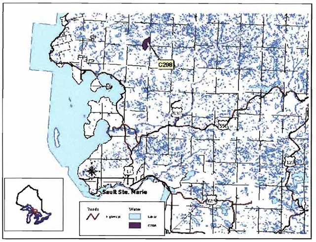
Harmony Forest Conservation Reserve protects rugged topography with stands of mature sugar maple and yellow birch mixed-woods dominating the landscape between the rock knobs, bedrock ridges and barren and scattered rock faces. Regulated on December 21, 2000, this 1,012 hectare conservation reserve is situated approximately 65 kilometers north of the City of Sault Ste. Marie, in the townships of Brule and Olsen.
Direction for establishing, planning and managing conservation reserves is defined under the Public Lands Act and current policy. The direction for managing this conservation reserve is in the form of a SCI, which defines the area that is being planned, provides the purpose for which the conservation reserve has been proposed, and outlines the Ministry of Natural Resources’ intent for the protected area. This SCI will provide both guidance for the management of the conservation reserve and the basis for ongoing monitoring of activities. More detailed direction at this time is not anticipated. However, should significant facility development be considered or complex issues arise requiring additional studies, more detailed management direction in the form of special protection measures, or a detailed Resource Management Plan, will be prepared with full public consultation.
Public and Aboriginal consultation occurred prior to the regulation of this conservation reserve during the planning for Ontario’s Living Legacy. Furthermore, there was a 15-day review period in November, 2002 concerning a draft of this SCI. Comments from the review period have been considered in the development of this document.
This SCI will be implemented by the Algoma Area Supervisor, and will be reviewed every five years and amended as required by the District Planner, Sault Ste. Marie District, Ministry of Natural Resources.
Submitted by: Erin Nixon Date: February 26, 2003
Recommended for Approval by:
Serge Tenaglia R.P.F
District Manager
Sault Ste. Marie District
Date: March 4, 2003
Approved by:
Rob Galloway
Regional Manager
Northeast Region
Date: May 30, 2003
1.0 Introduction
The following document is a Statement of Conservation Interest (SCI) for Harmony Forest Conservation Reserve (C298). The purpose of this SCI is to identify and describe the natural, recreational and cultural values of Harmony Forest Conservation Reserve and to outline the Ministry of Natural Resources’ management intent for this area. The first portion of this document highlights the provincial context in which it was produced, states its goal and objectives, and summarizes the planning process for conservation reserves. The second portion of this document is specific to Harmony Forest Conservation Reserve. Management direction provided in this SCI will serve to protect the conservation reserve for the benefit of all Ontario residents. This direction will comply with the land use intent stated in the Ontario’s Living Legacy Land Use Strategy (OMNR 1999).
1.1 Provincial context
Ontario’s network of natural heritage areas has been established to protect and conserve areas representative of the diversity of the natural regions of the province, including species, habitats, features and ecological systems which comprise that natural diversity. Protected natural heritage areas are a key component in the sustainable management of natural resources. They ensure that representative sites within the larger managed landscape are permanently retained in their natural state. Harmony Forest Conservation Reserve is part of Ontario’s network of natural heritage areas.
On July 16, 1999, the Ontario Government released the Ontario’s Living Legacy Land Use Strategy to guide the planning and management of Ontario’s Crown lands. Extensive consultation was conducted during the development of the Land Use Strategy. The objectives of the Land Use Strategy are to complete Ontario’s system of parks and protected areas; recognize the land use needs of the resource-based tourism industry; provide forestry, mining and other resource industries with greater certainty around land and resource use; and enhance hunting, angling and other Crown land recreational opportunities.
The Land Use Strategy (OMNR 1999) demonstrated the government’s commitment to completing Ontario’s system of protected natural heritage areas by designating 378 new areas to be protected. These areas are considered to be significant and require protection from incompatible activities in order for their values to endure over time. The addition of these 378 new areas marks the largest expansion of parks and protected areas in Ontario’s history. Harmony Forest Conservation Reserve was created as part of this expansion. It protects a dramatically rugged landscape of bedrock knobs and ridges with stands dominated by mature and old growth sugar maple (Acer saccharum Marshall) and yellow birch (Betula alleghaniensis Britton) mixed-woods covering the valley and upland sites.
The Ministry of Natural Resources has established conservation reserves as a tool to protect natural heritage areas on public lands, while permitting traditional public land uses to continue. These uses include recreational activities, such as hunting and fishing, and the traditional activities of Aboriginal societies, as defined under applicable Aboriginal Treaties. Lands designated as conservation reserves in the Land Use Strategy (OMNR 1999) are removed from the Sustainable Forest License, and mining and surface rights are withdrawn from staking under the Mining Act (RSO 1990 Chapter M.14).
[missing text] auspices of a SCI. It should be noted that this SCI addresses only those issues or land use proposals currently known to the District Manager. The direction provided by this SCI, and future management decisions, will resolve any future land use conflicts and will ensure that identified values continue to be adequately protected.
3.2.1 Planning area
The planning area for this SCI consists of the regulated boundary for the Harmony Forest Conservation Reserve (see Section 10.0, Map 1). However, to fully protect values within the conservation reserve, additional consideration within larger land use planning initiatives may be required. The forest management planning process is an example of how adjacent land management may consider sensitive features within the conservation reserve boundary.
3.3 Guiding principles
All current or planned activities within this conservation reserve should be in compliance with the following guiding principles. If a conflict between management guidelines exists, the following guiding principles will be used to discern management intent and resolve the issue.
- All management guidelines will be based on maintaining the long-term ecological integrity of the area.
- No new or existing uses will be permitted if it is deemed that they compromise the protected values.
- All attempts will be made to maintain traditional uses while protecting the values as per Section 5.0, and maintaining the long-term ecological integrity of the site.
- This conservation reserve was chosen to represent vegetation and landscape types unique to this site district and to Ontario. All efforts will be made to maintain those values identified in Section 5.0.
- Overall, management strategies will focus on maintaining the conservation reserve in as natural a state as possible.
4.0 Background information
4.1 Location and site description
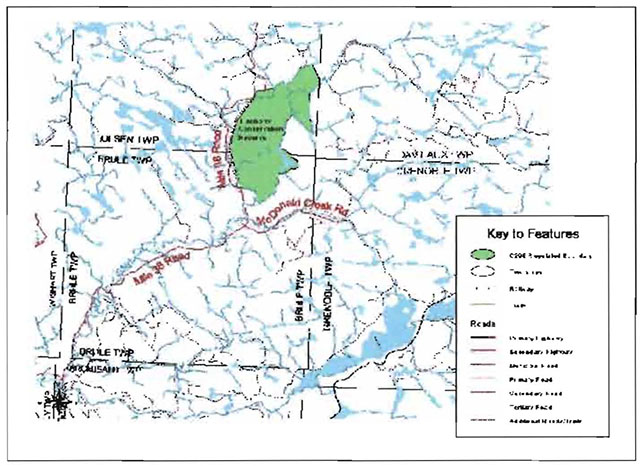
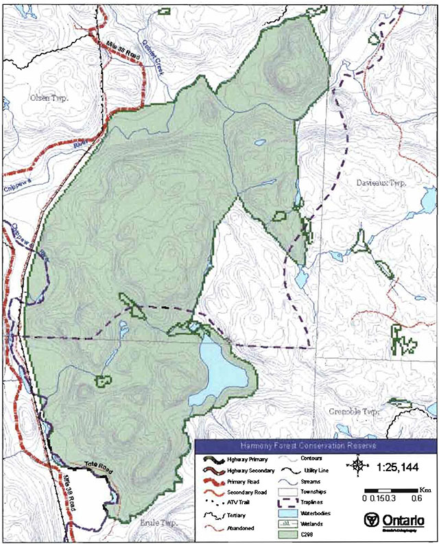
Harmony Forest Conservation Reserve is located approximately 65 km north of the City of Sault Ste. Marie, in Brule and Olsen Townships (Section 10, Map 1a). Whenever possible, natural and/or artificial features have been used to delineate site boundaries to facilitate on-the-ground identification of the boundaries. A hydro transmission corridor makes up the western boundary of the conservation reserve while the majority of the south, east and north boundaries follow the Chippewa River or its tributaries. Also, a portion of the northwest boundary follows the Mile 38 Road for a short distance.
Table 1 describes the location and administrative details of the site.
Table 1. Location and administrative details for the Harmony Forest Conservation Reserve
[Table 1 converted to a list]
- Name: Harmony Forest Conservation Reserve (C298)
- Site Region - Site District (Hills 1959): 4E-2 Batchawana
- Site region - Site District (Crins and Uhlig 2000): SE-13
- OMNR Administrative Region/District/Area: Northeast Region/Sault Ste. Marie District/Algoma Area
- UTM co-ordinates: 252708 E 5216765 N
- SCI Completed: January 20, 2003
- Regulated: December 21, 2000
- Area: 1012 ha
- Nearest Town/Municipality: Approximately 65km north of the City of Sault Ste. Marie
- Township(s): Olsen and Brule
- OBM Numbers: 2016700052100, 2016710052100
- Topographical Map Name/Number: 41N/1 Batchewana
- Wildlife Management Unit: 36
- Forest Unit: Algoma
4.2 History of the site
Stump evidence throughout the site indicates that all of the conservation reserve was logged for white pine (Pinus strobus L.) during the early 1900s. The logs were cut and stored by the Chippewa River during the winter months and floated downstream during the high water conditions of early spring. Horses hauled the logs to the river’s edge during the frozen, winter conditions, leaving little evidence of this activity. (P. Nenonen, M. Kalliojarvi, pers. comm.).
Two historic white pine logging camps were located within the conservation reserve’s boundaries. One camp was located along the periphery of the site, next to the Chippewa River in the southwest corner. The second camp in the northern section of the conservation reserve was nestled in a fork of the Chippewa River, at the junction between the river and a tributary coming from the south. Earthen piles at the latter site can still be seen today where the land is reclaiming the remains of the buildings. Both of these camps were serviced by a tote road which generally followed the east side of the Chippewa River wherever conditions allowed. Gradually, the white pine harvest faded as accessible tree numbers declined. Following World War II, the area once again experienced increased forest harvesting activity as the loggers moved in seeking valuable yellow birch veneer logs. During the 1950s, a small portion of the reserve was logged between the Mile 38 Road, which had reached McGovern Creek by this time, and the Chippewa River, east of the transmission line. The southern tip was also harvested during the same time frame. Yellow birch was found mainly on the lower reaches of the hills, so no attempt was made to access the rugged terrain of the upper slopes where less desirable maples dominated. (P. Nenonen and M. Kalliojarvi, pers. comm.).
During the late 1920s, the first power line was installed along what is now the west boundary of Harmony Forest Conservation Reserve. Hydro poles, supplies and equipment were brought in along roads leading from Mile 53 of the Algoma Central Railway. A second power line was put through the same corridor during the 1940s. The tote road, east of the Chippewa River, was used prior to the construction of the Mile 38 Road, located west of the river, for access along these lines. The Mile 38 Road, which terminated around McGovern Creek in the 1950s, was used for the next installment of the power line during the 1950s. This road was extended beyond the creek at the end of the 1960s and into the 1970s (M. Kalliojarvi, pers. comm.).
Remnants of various logging trails lead into the conservation reserve from the tote road or appear in places in the interior of the site. Just south of the northernmost logging camp location, a section of corduroy road is still visible. It was constructed over a boulder field that was too rough for horses to traverse. Cedar stringers, used to support the logs, remain on top of boulders that average approximately 3 to 4 cubic metres in size. (M. Kalliojarvi, pers. comm.).
Fire has played a minor role in shaping the landscape of this site. Evidence can be found in the northeast section of a very old fire, which likely burned prior to Ministry of Natural Resources’ records of fire occurrences in this area (M. Kalliojarvi, pers. comm.). In addition, lightning sparked a 9-hectare fire in the southeast section in 1998. This fire burned up a very steep slope charring magnificent white pine, sugar maple and red oak. Tree mortality occurred on the steep slope as the shallow soil that nourished the trees was burned away. Scar damage was more common on the trees at the top of the slope where the fire burned quickly across the soil surface.
4.3 Inventories
Table 2 indicates the current status of natural heritage inventories that have occurred and/or are required for Harmony Forest Conservation Reserve.
Table 2: Inventory and survey information for the Harmony Forest Conservation Reserve
| Survey level | Earth science | Life science | Cultural | Recreational |
|---|---|---|---|---|
| Reconnaissance | Fall 2001 | Fall 2001 | Fall 2001 | Fall 2001 |
| Detailed | Not required | Detailed life science inventory should be completed to assess the representation of the site within the site region and province. | Not required | Not required |
| Further Requirements | N/A | Assessment and analysis should be completed to further classify vegetation communities and ascertain the presence of Braun’s holly fern. Gather current baseline data on the mature hardwood maple/birch communities approaching the old growth stage and on the forest stand recently classified as old growth, in order to ascertain ecological changes over time. | N/A | N/A |
5.0 State of the resource
Interpretation of 1994 air photos indicates that Harmony Forest Conservation Reserve is largely undisturbed. An aerial reconnaissance survey completed in 2001 by the Ministry of Natural Resources showed no observable human disturbances despite records of selective harvesting in the southern tip of the conservation reserve during the early 1950s. Further cross-reference also indicates extensive logging for white pine throughout the area during the early 1900s. Please refer to Section 4.2 for more historical information.
The condition of the land surrounding the conservation reserve was considered to be healthy as well, with good connectivity to stands beyond the site’s boundaries in three directions. The western boundary is comprised of a hydro transmission corridor. While this corridor does provide a well-established cultural boundary, it also artificially separates the site from the communities west of the conservation reserve and leads to ecological fragmentation.
The key values (geological features and/or featured species) found within Harmony Forest Conservation Reserve include the following:
- Exquisite range of topography with steep ridges, cliffs and rock knobs harbouring extensively forested valleys, nestled between the Chippewa River on the west and north sides and a tributary north of MacDonald Creek in the south. In all, 32 landform/vegetation combinations create a rich diversity, unusual for such a small area.
- Dense, mature and old growth, sugar maple mixed-wood communities.
The key values are those values that make this site unique and have led to its designation as a conservation reserve. Their protection is paramount. Additional values as listed in Section 5.1 through to Section 5.5 are also important. This description is not necessarily complete. If new values are identified, they will be added to this section. If any new value is considered significant, management guidelines may be modified, if required, to ensure its protection.
5.1 Earth sciences
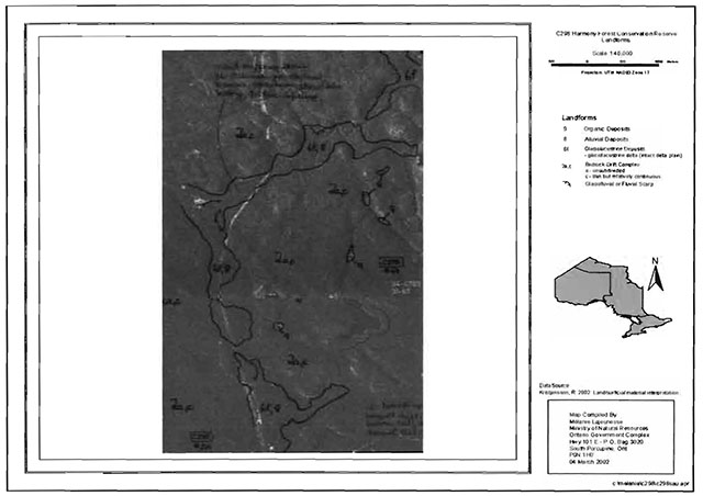
Harmony Forest Conservation Reserve is located in a very scenic area of Ontario. Situated approximately 17 kilometres inland from the Lake Superior coastline, this site falls within the Batchawana Site District 4E-2 (Hills 1959). This site district is known for its rugged topography that is a result of numerous geological structures, such as faults, joints, and diabase dikes. The bedrock uplands have a thin layer of sandy soil on the upper slopes and deeper soils in the valleys. Exposed bedrock is common in the area and dates back billions of years to the Precambrian and Cambrian periods. Pockets of “lacustrine deposits”, soils that were formed long ago in lakes, are also found in the area. The lowland areas in the site district are associated with Lake Superior and Lake Huron shorelines and are backed by a series of ridges that run east to west. The conservation reserve also contains glaciolacustrine and alluvial deposits associated with the Chippewa River, and small pockets of organic material affiliated with shorelines, small tributaries and wetland communities (Kristjansson, in prep., 2002).
Bedrock knobs and ridges as well as a high density of hardwood tree species, characterize this conservation reserve. Included with the five major landform features represented within this site are bedrock-drift cover complex, alluvial and glaciolacustrine deposits and isolated organic deposits (Lajeunesse and Thompson 2002).
5.2 Life sciences
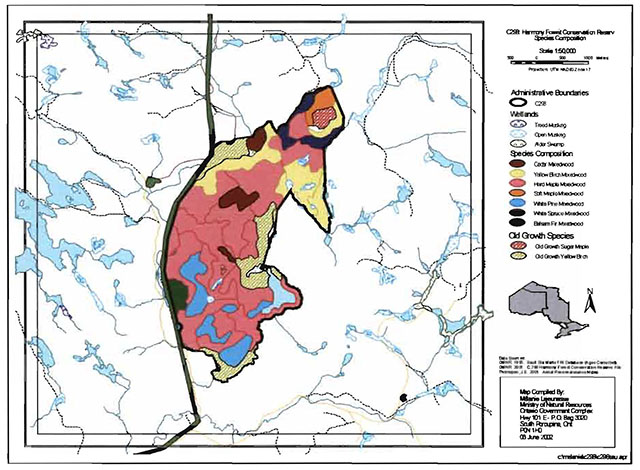
Harmony Forest Conservation Reserve can be characterized as having bedrock knobs and ridges with a high density of tolerant hardwood tree species dispersed throughout. The uplands and valleys of this conservation reserve are covered by mature and old growth stands dominated by sugar maple (Acer saccharum Marshall) and yellow birch (Betula alleghaniensis Britton). Most of the sugar maple communities are classified as mature with ages ranging from 97 to 137 years old. There is also one old-growth maple dominated community over 140 years old. Oldgrowth yellow birch (greater than 150 years) mixed-woods occur in large pockets along the eastern and northern borders of the site (Lajeunesse and Thompson 2002). The northeast corner of the site is comprised of an impressive landscape of bedrock knobs and ridges. One large rock knob and its associated slopes support maple, yellow birch, and white spruce (Picea glauca Moench) with white cedar (Thuja occidentalis L.), white pine (Pinus strobus L.) and occasionally white birch (Betula papyrifera Marshall) and balsam fir (Abies balsamea L.). Its southern face contains barren and scattered white spruce that abruptly falls towards a spruce, maple and yellow birch community along a small tributary of the Chippewa River.
White pine dominated forests cover many of the southern ridges. White pine and associated conifers clump together along rock faces and ridge edges while mixed stands of white pine and sugar maple colonize the tops of ridges. Maple dominated stands tend to be present in the lower elevations and valleys. The site’s extensive mature stands and one old growth (> 140 years) stand of sugar maple, are comprised with excellent stocking, between 60 and 100%. Stocking of less than 60% occurs only in white pine dominated stands, especially along the southern ridges or where rock faces resulted in barren and scattered coniferous dominated communities (Lajeunesse and Thompson 2002).
An isolated patch of mature red oak (Quercus rubra L.) with associated red oak regeneration has been identified close to the centre of the conservation reserve (M. Kalliojarvi, pers. comm.).
There are numerous lakes, ponds and feeder streams associated with the Chippewa River. Wetlands within the conservation reserve range from shoreline fen and sheltered marsh wetlands to more isolated bogs. Brook trout (Salvelinus fontinalis) is found in most of the creek systems throughout the area. One creek in the interior provides an excellent example of beaver channeling: as beaver dam construction did not raise water levels sufficiently to provide year-round access to the beaver houses, the beavers have dug numerous deep channels to bring water from the main stream to the houses (M. Kalliojarvi, pers. comm.). More field-based research and assessment is required to better understand the aquatic values and wetland features within the site.
Harmony Forest Conservation Reserve is located within Site District 4E-2. This district is known to provide suitable microclimates for the provincially significant Braun’s Holly Fern. This fern often grows on rocky slopes and moist cliffs in deciduous woods. It requires cool shaded areas to grow and is sensitive to logging activities (Wisconsin Department of Natural Resources 2001). To date, the occurrence of this species within this conservation reserve remains unknown.
Thirty-two landform/vegetation combinations have been identified throughout the small area of Harmony Forest Conservation Reserve. This, combined with the presence of old growth and mature forest communities, high stand stocking levels and water and wetland features, creates a high level of diversity, and an impressive degree of representation within this site region.
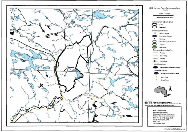
5.3 Recreational values
Very little recreational activity occurs within this site. Fishing for brook trout is a common activity in the Chippewa River along the periphery of the conservation reserve, and some hunting has occurred in the interior. Suitable habitat limits the availability of game and the absence of continuous trails creates obstacles to game retrieval (M. Kalliojarvi, pers. comm.).
The dramatically rugged topography of the Harmony Forest Conservation Reserve, with some elevations in excess of 450 metres, offers numerous opportunities for recreational activities. Features such as cliffs and rock outcrops, a river system, small, scattered wetlands and a small lake, are of high value. These features offer opportunities for photography, bird and wildlife viewing, rock climbing, hiking, snowshoeing, canoeing, kayaking, fishing and camping. With no roads and no established trails inside the conservation reserve, hunting opportunities also exist for the wilderness seeker.
While access to the west boundary of the site, via Mile 38 Road, is excellent, access into the conservation reserve itself requires ingenuity, local knowledge and resolve. Once accessed however, the rugged terrain and spectacular vistas can provide an exhilarating experience.
5.4 Cultural values
This site falls within the Robinson-Huron Treaty area. To date, no First Nation community has identified any specific cultural values within this conservation reserve.
5.5 Research values
Currently no known research and/or monitoring activities have occurred within this conservation reserve.
6.0 Management guidelines
All management guidelines in this SCI are based on policy and direction outlined in the Ontario Living Legacy Land Use Strategy (OMNR, 1999) and associated policy clarification statements. Management policies in this document may be subject to change and may be amended as necessary. These guidelines are specific to Harmony Forest Conservation Reserve, and provide for protection of the site’s unique features.
New proposed uses and development as well as research and education will be reviewed on a case-by-case basis. The Test of Compatibility (Appendix A – PL 3.03.05, Public Lands Act) must be passed with reference to Conserving a Future for our Past: Archaeology, Land Use Planning & Development in Ontario, Section 3 (MCzCR 1997) before new proposals will be permitted. In addition, all new proposals are subject to the Class Environmental Assessment for Parks and Conservation Reserves.
The following management strategies have been created to achieve the goal and objectives of Harmony Forest Conservation Reserve’s SCI.
6.1 Industrial activities
6.1.1 Commercial timber harvest
The area contained within this conservation reserve (1,013 ha) has been withdrawn from the Algoma Sustainable Forest License area and no commercial timber harvesting will be permitted. Please refer to Section 6.4.3 for information regarding non-commercial wood harvesting.
6.1.2 Mining and exploration
There are no known current mining interests within this conservation reserve. Mining and surface rights within the conservation reserve’s boundaries have been withdrawn from staking under the Mining Act (RSO 1990 Chapter M.14). Mineral exploration is not permitted.
6.1.3 Extraction of peat, soil, aggregate and other material
Extraction of peat, soil, aggregate and other material is not permitted.
6.1.4 Energy generation
Hydropower development and windpower generation is not permitted within the conservation reserve.
6.2 Existing and proposed development
6.2.1 Transportation corridors
6.2.1.1 Roads
According to the Land Use Strategy (OMNR 1999), new roads for resource extraction will not be permitted, except for those identified in Forest Management Plans prior to March 31, 1999. No new or existing roads for resource extractions were identified within this site.
6.2.1.2 Trails
Currently, no Voyageur Trail Association, or Ontario Federation of Snowmobile Clubs trails have been identified within this conservation reserve. The old tote road, which follows along the east side of the Chippewa River, still exists, with ease of access dependent upon windfall trees and maintenance by area users (M. Killiojarvi, pers. comm.). Any future trail development must consider the conservation reserve’s core values, specifically the earth science features that are protected within the boundaries of this site. Trail development in low-lying areas and wetlands will be discouraged as will trail development over shallow soils on rock outcrops and the fragile vegetation that grows on these sites. Any proposed new trails will be subject to the district work permit review process and the Test of Compatibility screening process (Appendix A). All new and existing trail heads and trail routes must be identified using new technologies (i.e. global positioning systems) to ensure the most accurate record of the feature. If new trails are approved, an amendment to this SCI will occur.
6.2.2 Other corridor development/maintenance
No communication, energy transmission, or other non-road corridors are located within this conservation reserve. New corridor developments will be actively discouraged through planning. Proposals for new corridors will be subject to the Test of Compatibility (Appendix A) and other applicable district policies.
6.2.2 Land disposition
No land will be sold within the boundaries of this conservation reserve.
6.2.3 Land tenure
Presently, one Land Use Permit (LUP) exists within this conservation reserve. Renewals of existing leases or Land Use Permits are permitted. With the exception of private recreation camps, new leases or land use permits may be issued for other approved uses, subject to the Test of Compatibility (Appendix A) and applicable district policy. These forms of land tenure will neither be patented nor phased out and may be eligible for enhanced tenure or transfer. Enhanced tenure is defined as anything beyond the term and form of current tenure. All requests for transfer or enhanced tenure will be subject to the following screening criteria:
- Is the transfer or enhanced tenure consistent with the conservation reserve’s land use intent, which is the protection and enhancement of the site’s natural, recreational and cultural values?
- Is it consistent with the land disposition policies outlined in the District Land Use Guidelines, the Crown Land Use Atlas, this SCI and any other applicable document?
- Does it adversely affect the values as identified in Section 5.0, and/or conflict with other uses?
- Is land needed by the Crown to protect significant natural or recreational values outlined in this SCI?
- Does the transfer or enhanced tenure clash with Aboriginal traditional uses, land claims or agreements?
- Are all rents, taxes, fees, rates or charges paid up for the existing LUP or lease?
6.3 Commercial activities
6.3.1 Commercial bait harvesting
No active commercial bait harvest operations or licences currently exist within this conservation reserve. However, Brule and Olsen Townships have been set aside for First Nation commercial bait harvest. At this time it is not known whether a local First Nation community or individual First Nation members, will obtain a commercial bait harvest licence in these townships. New operations can be considered within the conservation reserve subject to the Test of Compatibility (Appendix A) and applicable district policies.
Under the Public Lands Act and in conjunction with PL 3.03.08 “Buildings for Bait Harvesting Management”, cabins for the purposes of bait harvesting may be constructed on Crown land. However, the approval of such buildings within this conservation reserve should be avoided, and Crown land outside of the protected area used wherever possible.
6.3.2 Commercial fishing
There are no commercial fisheries within this conservation reserve.
6.3.3 Commercial fur trapping
Portions of Registered Trapline Areas SS12 and SS20 fall within the boundary of this conservation reserve. These registered trapline areas are currently allocated to head trappers. If a head trapper surrenders a registered trapline, or the head trapper’s privileges are revoked, the registered trapline may be transferred to another trapper following established allocation procedures. If the registered trapline is not transferred in due course, or remains unallocated for a significant period of time, reallocation of the trapline may occur following applicable district screening processes.
The establishment of new trapline trails will be considered following the procedure and criteria for new trails as outlined in Section 6.2.1.2. No trap cabins currently exist within Harmony Forest Conservation Reserve. The establishment of new trap cabins is not permitted within conservation reserves.
6.3.4 Bear management areas
This conservation reserve is located within Bear Management Area (BMA) SS-36-002. Guided hunting activities associated with a BMA may continue within this conservation reserve. Transfer of the BMA within this conservation reserve may be permitted in cases where the current operator sells his/her bear hunting business to another operator and the BMA transfer is approved. If an operator surrenders the BMA or the BMA is revoked, reallocation of the BMA may occur following applicable district screening processes.
6.3.5 Commercial food collection
There are no existing commercial food harvesting ventures within the site. New ventures will be subject to the Test of Compatibility (Appendix A) and the appropriate Ministry of Natural Resources’ policies and procedures.
6.3.6 Commercial non-timber forest products
Policy is currently being developed by the Planning and Research Section of Ontario Parks regarding commercial non-timber forest products. In the interim, proposals will be reviewed on a case-by-case basis, subject to the Test of Compatibility and applicable district policies.
6.3.7 Outpost camps/main base lodges
There are no existing authorized outpost camps or main base lodges within this conservation reserve. New outpost camps and main base lodges may be considered through planning and will be subject to the Test of Compatibility (Appendix A) and applicable district policies.
6.4 Non-commercial activities
6.4.1 Nature appreciation/recreation activities
Off-trail hiking, cross-country skiing, snowshoeing and other activities will be permitted within this conservation reserve. However, should the impact of these activities degrade the landscape of the conservation reserve, the Ministry will reevaluate these permitted uses and decide upon a new strategy for this site. New trails to support these activities may be considered. Please refer to Section 6.2.1.2 for more details related to trail development.
While camping is permitted within the conservation reserve, campers should make use of established campsites, where they exist, and avoid sensitive areas such as wetlands.
6.4.2 Natural heritage appreciation facilities/recreational structures
Within this conservation reserve, there are no existing authorized natural heritage appreciation facilities or recreational structures, such as boardwalks, bird viewing platforms, kiosks, ski shelters, or interpretative signs. New natural heritage appreciation facilities and recreation structures are permitted and encouraged, subject to the Test of Compatibility (Appendix A).
6.4.3 Non-commercial consumptive resource use
Cutting of trees for non-commercial purposes within this conservation reserve may be authorized by permit issued by the local Ministry of Natural Resources’ Office, subject to a review and determination of the impact that such cutting would have on the values identified in Section 5.0. This flexibility is intended only for leaseholders, Land Use Permit holders, cottagers and other property owners within the conservation reserve who do not have road access to their property and have no alternative wood source outside of the conservation reserve area. This permit is intended to cover fuelwood, dock stringers, and other occasional small scale uses.
It should be noted that the mature sugar maple and yellow birch mixed-wood communities found in the southwest section of this conservation reserve have been identified as significant features and harvesting in this area is prohibited.
Non-commercial harvesting of non-timber products such as berries, mushrooms, sphagnum moss (Sphagnum spp.) and wild rice (Zizania L.) can occur provided the values of the site (Section 5.0) are not jeopardized.
6.4.4 Hunting and fishing
Hunting is a traditional use of this conservation reserve and has been identified as an important value. In conjunction with current hunting regulations and adherence to the guiding principles (Section 3.3), hunting is permitted to continue.
Recreational fishing is also permitted to continue in compliance with current fishing regulations.
6.4.5 ATV and snowmobile use
No authorized snowmobile trails have been identified within this conservation reserve. Please refer to Section 6.2.1.2 for more information on trails. In general off-trail use of ATVs and snowmobiles is not permitted within this conservation reserve. However, off-trail use is accepted for licenced trappers to access their traplines and for licenced bait harvest operators while conducting bait harvest operations. Off-trail ATV and snowmobiling is also accepted for the direct retrieval of large game by hunters. In all cases, off-trail use is only permitted provided the protection of the site’s values, as per Section 5.0, is not compromised. Should the impact of off-trail ATV and snowmobile use degrade the landscape of the conservation reserve, the Ministry of Natural Resources will re-evaluate these permitted uses and determine a new strategy.
6.5 Resource management activities
Resource management activities refer to those tools used to protect and enhance the values of this conservation reserve. Some management activities may require the use of intrusive techniques. Under normal circumstances, some of these techniques would not be permitted to occur in the conservation reserve; however, if they are found to be necessary, they may be applied under controlled conditions, to achieve a desired result. Infrastructure such as roads, trails and buildings may need to be constructed to perform activities such as prescribed burns, forest regeneration, wildfire control, and insect and disease control. Activities described in this section will be deemed acceptable if the ultimate outcome is in compliance with the guiding principles of this SCI.
6.5.1 Fish stocking
No waterbodies within this conservation reserve have been stocked, or are currently being considered for stocking.
6.5.2 Insect and disease control
In accordance with the guiding principles, this conservation reserve will be maintained in as natural a state as possible. Insect and disease control measures should only be considered if the identified values are significantly threatened.
6.5.3 Fire management
Fire protection will be carried out in accordance with current Ministry of Natural Resources’ fire management strategies. When aggressive fire suppression is undertaken, techniques that may excessively damage the site, such as heavy equipment use, trenching, camp construction, tree cutting, etc., should be avoided within the conservation reserve except where an excavation is required due to the occurrence of a deep-seated peat fire. If it is deemed that human life or property is in jeopardy, all necessary fire suppression measures should be undertaken regardless of potential damage to any of the protected values in this conservation reserve.
Due to the exposure of large trees located on rock knobs in areas of high elevation, Harmony Forest Conservation Reserve is prone to fires caused by lightning strikes. Prescribed burning may be considered if fire has not occurred for a sustained period of time and it is determined that the features of this site would benefit from controlled burning (e.g. to promote regeneration).
6.5.4 Management for key values
Management that maintains or improves the conditions of the site’s key values is permitted on a case-by-case basis and is subject to the Test of Compatibility (Appendix A). Please refer to Section 5.0 for a list of the site’s key values. Management may also include habitat or ecosystem management.
6.5.5 Forest renewal
The preferred regeneration option after any natural disturbance is natural regeneration. In some cases, regeneration may be artificially assisted when it is deemed appropriate to mitigate against human disturbances (e.g. illegal occupation and trespass).
6.6 Research
Scientific research is encouraged, by qualified individuals or institutions, that contributes to a better understanding of the natural and cultural values protected by this conservation reserve or that advances the protection, planning and management of these values. The Sault Ste. Marie District Planner should be contacted for information on research and/or monitoring opportunities within this conservation reserve. Proposals to conduct research should be directed to the Algoma Area Supervisor, Ministry of Natural Resources, Sault Ste. Marie District Office, and will be subject to the Test of Compatibility (Appendix A), to ensure that no values will be damaged in the process. Any site that is disturbed during research activities is to be rehabilitated as closely as possible to its original condition. Research programs will also be subject to Ministry policies and other legislation. Collecting may only be permitted as part of an authorized research project.
Existing Forest Resource Inventory surveys and approved resource monitoring activities are permitted to continue.
The Harmony Forest Conservation Reserve has potential as a research and monitoring site. With 32 recognized landform/vegetation types occurring within such a small area, together with old growth and mature forest communities, further investigation to determine the extent of the species diversity on this site is encouraged.
Based on comments received in the fall of 2002 from a local area user, there is concern that brook trout populations are in decline in the portion of the Chippewa River bordering the northern section of the conservation reserve. This individual’s observations indicate that over a 15 year period from the mid-1970s through to 1990, summer water temperatures in that section of the river have shifted from very cold to quite warm. This information leads to speculation that the trout populations may be receding in concert with increased water temperatures. Efforts should be made to work with partner research institutions to gather baseline data from which future monitoring can be based or an investigation can be undertaken.
6.7 Marketing
No active marketing of this conservation reserve is anticipated.
6.8 First nations
Traditional activities and Aboriginal rights, as defined in the Robinson-Huron Treaty and other relevant acts, will not be affected within or by the boundaries of this conservation reserve.
Any First Nation land claims within this area will be addressed according to appropriate Ministry of Natural Resources’ procedures. When possible, the Ontario Ministry of Natural Resources will continue to work with the Ontario Ministry of Tourism, Culture and Recreation in identifying archaeological sites to be protected.
7.0 Recommendations
7.1 Additions to the reserve
Many of the landforms and forest communities present within Harmony Forest Conservation Reserve extend beyond the site’s boundaries onto surrounding Crown and private land. Specifically, some of the forest stands approaching old growth status extend beyond the present boundary to the east and south of the conservation reserve. As well, high elevation slopes with exceptionally steep grades can be found just north of MacDonald Creek, south of the current southern boundary. Additional protection of these forest communities and topographical features may result from their consideration within a broader planning process. This may also be accomplished by the addition of adjacent Crown lands into the conservation reserve, although no specific areas have been identified to date.
7.2 Future needs and considerations
The following recommendations should be considered in any future planning initiatives for this conservation reserve:
- Partnership Development - Efforts should be made to work with partners (such as the Ontario Forest Research Institute (OFRI), Sault College of Applied Arts and Technology) to gather baseline data on this site. This data will be used for future monitoring and inspection activities.
- Research and Monitoring - It is recommended that the conservation reserve be considered as a potential research and/or monitoring site, by the Ministry of Natural Resources or its partners. This is due to the presence of 32 landform/vegetation types in addition to the mature and old growth stands of sugar maple and yellow birch. Also suggested is a project to gather baseline data on brook trout populations and water temperatures of the Chippewa River in the northern reaches of the conservation reserve. It is recognized that the site’s limited access could be problematic for future research initiatives.
- Boundary Delineation - Boundaries of the conservation reserve should be clearly marked as well as identified using Global Positioning System technology, specifically along the vectored boundaries to ensure protection of core values.
- Any future trail development must consider the conservation reserve’s core values, especially the earth science features that are protected within the boundaries of the conservation reserve. Trail development in low-lying areas and wetlands should be discouraged.
- Values Protection -The values of the site should be considered in land use management activities on Crown lands adjacent to the site to ensure sufficient protection of the site’s core values.
- Flora and Fauna Assessment - To complement the aerial reconnaissance completed in 2001, a field assessment should be completed to further classify and analyze the vegetative communities with special attention to the aquatic communities present. Because this site is located within the northern portion of the Great Lakes St. Lawrence forest region, vegetation and key faunal species lists should be expanded.
- Water Levels- Recognizing that community and species diversity in wetlands is maintained by fluctuating water levels, efforts should be made to ensure natural water level fluctuations continue undisturbed within this site.
- Funding - Efforts will be made to obtain funding to support further inventory, monitoring, assessment, research or inspection requirements for this site.
7.3 Monitoring
Periodic monitoring of human activities within this conservation reserve will be conducted. A schedule for cursory field monitoring will be identified within the District’s annual compliance plan and an IFM (Integrated Field Monitoring) inspection report will be filed at the Sault Ste. Marie District Office. The Algoma Area Supervisor will oversee these activities. If at any time human activities are deemed to be negatively impacting the protected features, the activities will be reviewed and measures taken to mitigate any disturbance.
Approved inventory, monitoring, assessment or research activities that are compatible with protection objectives are encouraged. Any area that is disturbed during research activities is to be rehabilitated as closely as possible to its original condition. The Algoma Area Supervisor may apply additional conditions.
8.0 Implementation, review and revisions
8.1 Responsibility
The Sault Ste. Marie District will be responsible for implementing the management policies and guidelines for Harmony Forest Conservation Reserve (C298). The primary role will be to provide public information and compliance monitoring to ensure adherence to current policies and guidelines.
8.2 Review and revisions
The Harmony Forest Conservation Reserve SCI will be reviewed every five years by the District Planner to confirm and update the information in this document. Revisions to this document will be subject to the requirements as specified in the Class Environmental Assessment for Provincial Parks and Conservation Reserves. If changes in management direction are needed at any time, the significance of the changes will be evaluated. Minor amendments to the plan that do not alter the overall protection objectives may be considered and approved by the Area Supervisor without further public consultation. In assessing major amendments, the need for a more detailed Resource Management Plan (RMP) will first be considered. Where a RMP is not considered necessary or feasible, a major amendment may be considered with public consultation. Major amendments will be recommended by the District Manager and approved by the Regional Director, and will follow the appropriate guidelines (OMNR 2001).
9.0 Literature cited
Crins, W.J. and P.W.C. Uhlig. 2000. Ecoregions of Ontario: Modification to Angus Hills’ Site Regions and Site Districts - Revisions and Rationale.
Hills, G.A. 1959. A Ready Reference for the Description of the Land of Ontario and its Productivity. Preliminary Report. Ontario Department of Lands and Forests. Maple. Ontario.
Kristjansson, R. 2002. Earth Science Checksheet, in prep. and aerial landform/surficial deposit photo interpretation. Unpublished information.
Lajeunesse, M. and J.E. Thompson. 2002. Harmony Forest Conservation Reserve, Natural Heritage Area - Life Science Checksheet. Unpublished information. OMNR.
Ministry of Citizenship, Culture and Recreation. 1997. Conserving a Future for Our Past: Archeology Land Use Planning and Development in Ontario, Section 3.
Ministry of the Environment. 2001. Guide to Eating Ontario Sport Fish. 21st edition. Queen’s Printer for Ontario.
Nathwani, N. 2001. Recreation Inventory Checklist for Harmony Forest Conservation Reserve. Unpublished information. Ontario Ministry of Natural Resources. Sault Ste. Marie District.
Ontario Ministry of Natural Resources, 1997. Conservation Reserves. Lands and Waters Branch Policy PL 3.03.05. Date Issued: February 11, 1997.
Ontario Ministry of Natural Resources, 1999. Ontario’s Living Legacy Land Use Strategy. Queen’s Printer for Ontario. Ontario.
Ontario Ministry Natural Resources, Sept 2000. Policy Clarification for Conservation Reserves. Unpublished document.
Ontario Ministry Natural Resources, 2000. Harmony Forest Conservation Reserve. Ontario Ministry of Natural Resources, Sault Ste. Marie District.
Ontario Ministry Natural Resources(c), 2001. Application, Review and Land Disposition - Building for Bait Harvesting Management. Public Lands Act, PL4.02.01, Schedule A.
Ontario Ministry Natural Resources, 2001. Procedures for the Amendment of Ministry of Natural Resources Land Use Direction. Ontario Ministry of Natural Resources.
Uhlig, P., A. Harris, G. Craig, C. Bowling, B. Chambers, B. Naylor and G. Beemer. 2001. Old growth forest definitions for Ontario. Ontario Ministry of Natural Resources Report.
10.0 Maps
Map 1a: Location of the Harmony Forest Conservation Reserve (C298)
Map 1b: Location of the Harmony Forest Conservation Reserve (C298)
Map 1c: Location of the Harmony Forest Conservation Reserve (C298)
Map 2: Air photo showing landforms in Harmony Forest Conservation Reserve (C298)
Map 3: Harmony Forest Conservation Reserve (C298): Tree species composition map
Map 4: Harmony Forest Conservation Reserve (C298): Recreation values map
11.0 Photos
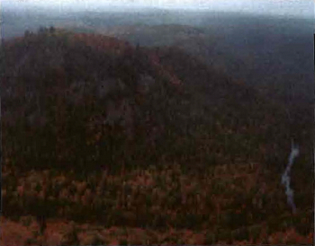
Photo 1: Northeast Corner. View of bedrock knob with incidental white birch, white pine and white spruce and in the lower reaches, a predominantly yellow birch/maple mixed-wood. (Photo taken by John E. Thompson during aerial reconnaissance survey, OMNR; 26 Sep 2001)

Photo 2: Southwest Boundary. View of very steep, exposed rock face of southernmost ridge. Portion of rock face burned by wildfire 1999. (Photo taken by John E. Thompson during aerial reconnaissance survey, OMNR; 26 Sep 2001)
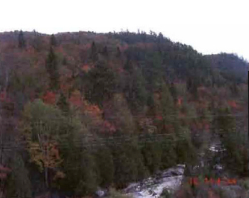
Photo 3: Southwest Boundary. View of mixed species composition at lower slopes along the Chippewa River. (Photo taken by Gerry Morin OMNR; 10 Oct 2002)
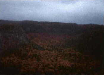
Photo 4: Southeast Boundary. View of valley with yellow birch/maple/cedar mixed-woods. (Photo taken by John E. Thompson, OMNR; 26 Sep 2002)
Appendix A: SCI Test of Compatibility
Test of Compatibility
-
Conformity to SCI/RMP: SCI describe values for which an area has been set aside and the range of appropriate uses that will be permitted in the area. SCI may also speak to the acceptability of other ‘new’ uses currently not occurring in the area.
The first ‘test’ is: “do proposed new land uses and/or commercial activities conform to the direction of the SCI/RMP for the conservation reserve? Would the new use(s) depart from the spirit of appropriate indicator land uses in the SCI/RMP?”
- Screening Process - proposed uses for the area must be assessed before they are approved. To establish a minimum standard, Northeast Region (NER) recommends that the Screening Process identified in Section 4.2 of A Class EA for Provincial Parks and Conservation Reserves Phase IIb: Draft Class EA (subject to approval by MOE) be used to screen projects and options.
- Impact Assessment: If the proposed use(s) pass test 1 it is important to determine their impact on the area before they are approved. This should include the following:
- Impact on natural heritage values: “will the new use(s) impact any natural values in the area? If so how and to what degree? Is it tolerable?”
- Impact on cultural values: “will the new use(s) impact an historical or archaeological values in the area?”
- Impact on research activities: “will the new use(s) affect research activities in the area?”
- Impact on current uses: “will the new use(s) have any negative impact on the array of current uses?”
- Impact on area administration: “will the new use(s) increase administrative costs and/or complexity?” (For example, the cost of area monitoring, security and enforcement).
- Impact on accommodating the use outside the conservation reserve: “Could the use(s) be accommodated as well or better outside the conservation reserve?”
- Impact on socio-economics of the area: “will the new use(s) affect the community(ies) surrounding the area in a positive or negative way?” (For example, will the new use make an area less remote thereby affecting a local tourism industry that is dependent on the area’s remoteness for its appeal?"
- Impact on area accessibility: “does the new use(s) give someone exclusive rights to the area or a portion of the area to the exclusion of other existing uses?”
The class EA (Table 4.1) presents similar values and concepts under the following considerations:
- Natural environment
- Land use, resource management
- Social, cultural and economic
- Aboriginal
The above considerations and classes of values are meant to assist planning staff in answering the following questions for any potential use:
- Will the new use impact any values within the Conservation Reserve?
- If so how?
- To what degree?
- Is it tolerable?
Appendix B: Summary of permitted uses
Crown Land Use Atlas policy report
Updated: September 25, 2002
Identification:
- ID: C298
- Area Name: Harmony Forest
- Area (ha): 1,012
- Designation: Conservation Reserve (Ontario’s Living Legacy)
- District(s): Sault Ste. Marie
Description:
This conservation reserve, in Site District 4D-2 contains a lacustrina landform with hardwood forests that include old stands of sugar maple, yellow birch and red maple.
Harmony Forest was regulated as a conservation reserve on December 21, 2000.
Land Use Intent:
Management of this area is also governed by the general policies contained in the Land Use Strategy (1999).
Management direction:
Those uses and management activities not listed in the following table are governed by existing conservation reserve policy. Over time the management direction will be elaborated in a Statement of Conservation Interest or Resource Management Plan. Any new uses, and commercial activities associated with conservation reserves, will be considered on a case by case basis, and they must pass a test of compatibility to be acceptable. Compatibility is normally determined through a planning process.
Commercial activities
| Activity | Permitted | Guidelines |
|---|---|---|
| Aggregate Extraction | No | N/A |
| Bait Fishing - Existing: | Yes | Existing use permitted to continue, unless there are significant demonstrated conflicts. |
| Bait Fishing - New: | Maybe | New operations can be considered, subject to the “test of compatibility” |
| Commercial Fishing - Existing: | Yes | Existing use permitted to continue, unless there are significant demonstrated conflicts. |
| Commercial Fishing - New: | Maybe | New operations can be considered, subject to the “test of compatibility”. |
| Commercial Fur Harvesting - Existing: |
Yes | Existing use permitted to continue, unless there are significant demonstrated conflicts. Existing trap cabins can continue; new cabins are not permitted. |
| Commercial Fur Harvesting - New: |
Maybe | New operations can be considered, subject to the “test of compatibility”. |
| Commercial Hydro | No | N/A |
| Commercial Timber Harvest |
No | N/A |
| Commercial Tourism - Existing: | Yes | Existing authorized facilities can continue, unless there are significant demonstrated conflicts. |
| Commercial Tourism - New: | Maybe | New tourism facilities can be considered during the planning for an individual reserve. |
| Bear Hunting by Nonresidents (guided) - Existing: | Yes | Existing authorized operations permitted to continue. |
| Bear Hunting by Nonresidents (guided) - New: | Maybe | New operations not permitted. |
| Outfitting Services - Existing: | Yes | Existing authorized operations permitted to continue. |
| Outfitting Services - New: | Maybe | New operations can be considered during the planning for an individual reserve. |
| Outpost Camps - Existing: | Yes | Existing authorized facilities permitted to continue. |
| Outpost Camps - New: | Maybe | New facilities can be considered during the planning for an individual reserve. |
| Resorts/lodges - Existing: | Yes | Existing authorized facilities permitted to continue. |
| Resorts/lodges - New: | Maybe | New facilities can be considered during the planning for an individual reserve. |
| Energy Transmission and Communications Corridors - Existing: | Yes | These facilities should avoid conservation reserve lands wherever possible. |
| Energy Transmission and Communications Corridors - New: | No | These facilities should avoid conservation reserve lands wherever possible. |
| Food Harvesting (Commercial) - Existing: | Maybe | N/A |
| Food Harvesting (Commercial) - New: | Maybe | N/A |
| Mineral Exploration and Development | No | N/A |
| Peat Extraction Wild Rice Harvesting - Existing: | Yes | N/A |
| Peat Extraction Wild Rice Harvesting - New: | Maybe | N/A |
Land and resource management activities
| Activity | Permitted | Guidelines |
|---|---|---|
| Crown Land Disposition - Private Use: | Maybe | Sale of lands is not permitted, except for minor dispositions in support of existing uses (e.g. reconstruction of a septic system). Renewals of existing leases and land use permits are permitted. Requests for transfer of tenure will be considered in the context of the Statement of Conservation Interest or Resource Management Plan. New leases or land use permits permitted for approved activities. Tourism facilities can apply to upgrade tenure from LUP to lease. |
| Crown Land Disposition - Commercial Use: | Maybe | Sale of lands is not permitted, except for minor dispositions in support of existing uses (e.g. reconstruction of a septic system). Renewals of existing leases and land use permits are permitted. Requests for transfer of tenure will be considered in the context of the Statement of Conservation Interest or Resource Management Plan. New leases or land use permits permitted for approved activities. Tourism facilities can apply to upgrade tenure from LUP to lease. |
| Fire Suppression | Yes | Fire suppression policies are similar to adjacent Crown lands, unless alternative fire policies have been developed through a planning process. |
| Fish Habitat Management | Maybe | N/A |
| Fish Stocking | Maybe | N/A |
| Insect/disease suppression | Maybe | N/A |
| Prescribed Burning | Maybe | N/A |
| Roads (Resource Access) - Existing: | Yes | Existing roads can continue to be used. Continued use will include maintenance and may include future upgrading. |
| Roads (Resource Access) - New: | Maybe | New roads for resource extraction will not be permitted, with the exception of necessary access to existing forest reserves for mineral exploration and development. |
| Vegetation Management | Maybe | Conservation Reserves policy indicates that Featured Species Management and Natural Systems Management may be permitted. Vegetation management can be considered in a planning process. |
| Wildlife Population Management | Maybe | N/A |
Science, education and heritage appreciation
| Activity | Permitted | Guidelines |
|---|---|---|
| Collecting | No | N/A |
| Historical Appreciation | Yes | N/A |
| Nature Appreciation | Yes | N/A |
| Photography and Painting | Yes | N/A |
| Research | Yes | N/A |
| Wildlife Viewing | Yes | N/A |
Recreation activities and facilities
| Activity | Permitted | Guidelines |
|---|---|---|
| All Terrain Vehicle Use - On Trails: | Yes | Existing use permitted to continue where it does not adversely affect the values being protected. |
| All Terrain Vehicle Use - Off Trails: | No | ATV use off trails is not permitted except for direct retrieval of game. |
| Campgrounds | Maybe | N/A |
| Food Gathering | Yes | N/A |
| Horseback Riding(trail) | Yes | Existing use on trails permitted. |
| Hunting | Yes | N/A |
| Mountain Bike Use | Yes | Existing use on trails permitted. |
| Motor Boat Use - Commercial: | Yes | N/A |
| Motor Boat Use - Private: | Yes | N/A |
| Non-motorized Recreation Travel | Yes | N/A |
| Private Recreation Camps (Hunt Camps) - Existing: | Yes | Existing camps permitted to continue, and may be eligible for enhanced tenure, but not purchase of land. |
| Private Recreation Camps (Hunt Camps) - New: | No | N/A |
| Rock Climbing | Maybe | N/A |
| Snowmobiling - On Trails: | Yes | Existing use permitted to continue where it does not adversely affect the values being protected. |
| Snowmobiling - Off Trails: | Maybe | Snowmobile use off trails Is not permitted, except that snowmobiles may be used for direct retrieval of game. |
| Sport Fishing Trail Development - Existing: | Yes | Development of trails for a variety of activities (e.g. hiking, cross-country skiing, cycling, horseback riding, snowmobiling) can be considered as part of planning for an Individual reserve. |
| Sport Fishing Trail Development - New: | Maybe | Development of trails for a variety of activities (e.g. hiking, cross-country skiing, cycling, horseback riding, snowmobiling) can be considered as part of planning for an Individual reserve. |
Note: The policies outlined in this table do not supersede any Aboriginal or treaty rights that may exist, or other legal obligations.
Management of this conservation reserve is carried out within the context of Conservation Reserve policy as amended by the policies for new conservation reserves outlined in the Ontario’s Living Legacy Land Use Strategy.
Source of direction:
Ontario’s Living Legacy Land Use Strategy (1999)
Conservation Reserves Policy (1997)
Appendix C: Public consultation handouts
64 Church Street
Sault Ste. Marie. ON
P6A 3H3
Telephone:
Fax:
November 10, 1999
As stated in the Land Use Strategy, the boundary refinement process will consider local ecological information and will attempt to locate regulated boundaries along features that can be identified.
64 Church Street
Sault Ste. Marie, ON P6A3H3
Facsimile:
E-mail: serge.tenaglia@mnr.gov.on.ca
November 10, 1999
To: Ontario Living Legacy Stakeholders
Dear Sir/Madam:
On July 16, 1999, the Ontario Government released Ontario Living Legacy Strategy, a broad land use strategy for the planning and management of much of me Crown lands in central and parts of northern Ontario. A major part of Ontario’s Ontario Living Legacy Strategy was a government commitment to the biggest expansion of provincial parks and conservation reserves in Ontario’s history. Ontario intends to add 378 new areas to its protected area’s system. Ontario Living Legacy is a momentous achievement that will be recognized around the world as a significant contribution to sustaining our natural environment. A copy of the Land Use Strategy is available from our office upon request.
In accordance with the recommendations in Ontario’s Living Legacy Land Use Strategy, the Ministry of Natural Resources is now beginning the process of establishing the first set of 64 protected areas from the Land Use Strategy. The first step in this process is consultation on the boundaries of these 64 areas. The remaining 314 proposed protected areas will be consulted upon in the future.
As stated in the Land Use Strategy, the boundary refinement process will consider local ecological information and will attempt to locate regulated boundaries along features that can be identified on the ground. This boundary refinement process may result in modest increases or decreases in the sizes of the areas. Any existing commitments for the areas which were considered during the land use planning process, will be considered in defining the final boundary.
This list of 64 areas includes the proposed Wabos North and Wabos South, Jollineau, La Verendrye/Ogidaki, Garden River Forest, Tilley Creek West, O’Connor and Harmony Conservation Reserves.
The Land Use Strategy established the Ministry’s intent to add these Crown lands to Ontario’s protected area’ system. Following the extensive public consultation associated with Ontario’s Living Legacy and the Lands for Life land use planning initiatives between 1997 and 1999. Prior to the finalization of me boundary of these conservation reserves proposed for regulation under the Public Lands Act, the Ministry is inviting public comment on the proposed boundaries.
Your name and address have been included within a Ministry mailing list to advise potentially Interested persons about these new conservation reserves. This mailing list includes a broad group such as nearby landowners, resource users, persons with other rights or tenure (e.g. land use permit, Mining Act rights), municipalities and others who may have an interest in these areas.
Information describing these proposed areas is attached. More detailed mapping and information about the proposed boundaries are available from this office.
In the future and subject to the intended regulation of these areas as conservation reserves, the Ministry of Natural Resources will undertake a management planning process to determine the long-term management of these protected areas. Depending upon the complexity of issues related to conservation reserves, management planning may take the form of a simple Statement of Conservation Interest or a more detailed Resource Management Plan. Please let us know if you would like to be notified when planning begins.
Planning, management and permitted uses within these conservation reserves would be consistent with the commitment of Ontario’s Living Legacy Strategy.
The Ministry is collecting comments and information regarding these proposed conservation reserve boundary reviews under the authority of the Public Lands Act to assist in making decision determining further public consultation needs. Comments and opinions will be kept on file and may be included in study documentation that is made available for public review. Under the Freedom of Information and Privacy Act (1987), personal information will remain confidential unless prior consent is obtained. However, the Ministry may use this information as public input on other resource management surveys or projects. For further information regarding this Act, please contact Wayne Fiset, Information Management Supervisor, Ministry of Natural Resources, Sault Ste, Marie District
If you would like to discuss the proposed boundaries and the protection of these areas under the Public Lands Act, please contact Erin Nixon, Community Planner, Ministry of Natural Resources, 64 Church St., Sault Ste. Marie, P6A 3H3, telephone:
Thank you for your interest.
Yours sincerely,
Signed by:
Serge Tenaglia
District Manager
Harmony Forest Conservation Reserve (C298) fact sheet
January, 2001
Background
On July 16, 1999, the Ontario Government released Ontario’s Living Legacy Land Use Strategy to guide the planning and management of Crown lands in central and parts of northern Ontario. A major part of Ontario’s Living Legacy Land Use Strategy was a government intent to establish 378 new protected areas. This commitment marks the biggest expansion of provincial parks and conservation reserves in Ontario’s history.
The Harmony Forest Conservation Reserve is part of this significant expansion of Ontario’s protected areas system. Following public and aboriginal consultation in late 1999 and early 2000 on refining the boundary of this protected area, Ontario Regulation 805/94 of the Public Lands Act was amended on January 6, 2001, by Ontario Regulation 686/00, to formally establish this conservation reserve.
Size and location
The 1,012-ha Harmony Forest Conservation Reserve is approximately 65 km north of the City of Sault Ste. Marie. Located in the townships of Brule and Olsen, this reserve is situated south of the Chippewa River and north of McDonald Creek.
Area highlights
The Harmony Forest Conservation Reserve is located in a scenic area of Ontario along the Lake Superior coastline between Agawa Bay and Gros Cap that is known by resource managers as “ecological site district 4E-2”. Extending inland for approximately 60-90 km, this ecological unit has a rugged topography and elevations exceeding 450 metres. Its topography is the result of numerous geological structures such as faults, joints, and diabase dikes that dissect the area. The bedrock uplands have a thin layer of sandy soil on the upper slopes and thicker soils in the valleys. Exposed bedrock is common, and dates back billions of years to the Precambrian and Cambrian periods. Pockets of “lacustrine deposits”, soils that were formed long ago in a lake, are also found in the area.
Located within the Algoma Forest Section of the Great Lakes-St. Lawrence Forest Region, the Harmony Forest Conservation Reserve is characterized by a high proportion of tolerant hardwood trees. Old sugar maple and yellow birch stands cover the valleys and uplands of the reserve, as well as mixed stands of sugar and red maple. A number of small ponds and streams that feed into the Chippewa River system are also present.
While a detailed biological study has not been conducted within the conservation reserve, a number of significant species are known to be present within site district 4E-2. The provincially significant wood turtle has been recorded here, while the increasingly rare snapping turtle reaches the northern limits of its range. The endangered bald eagle breeds here as well as the provincially significant least bittern, red-shouldered hawk, American coot, and long-eared and short-eared owls. Many rare vascular plants have been recorded, including Braun’s holly fern, the limestone oak fern, the lance-leaved coreopsis, and the monkey flower.
Land use intent
Conservation reserves are areas of Crown land set aside by regulation under the Public Lands Act.
Conservation reserves complement provincial parks in protecting representative natural areas and special landscapes. Most recreational activities (e.g. hiking, skiing, tourism related uses, nature appreciation) and non-industrial activities (e.g. fur harvesting, commercial fishing and bait harvesting) that have traditionally been enjoyed in the area will continue, provided that these uses do not impact on the natural features needing protection. Hunting and fishing are also permitted within all new conservation reserves proposed through Ontario’s Living Legacy.
Commercial timber harvesting, mining, aggregate extraction and commercial hydroelectric development are prohibited in conservation reserves. Careful mineral exploration may occur in specific new conservation reserves proposed through Ontario’s Living Legacy, in areas that have provincially significant mineral potential. If a portion of a new conservation reserve is to be developed for a mine, it would be removed from the reserve, and appropriate replacement lands would be placed in regulation. Please refer to Table 4 from the Land Use Strategy for a detailed summary of permitted uses in conservation reserves.
Next steps
This regulated area has been withdrawn and protected from resource extraction activities such as timber harvesting, hydroelectric development, aggregate extraction and new mineral exploration.
In the future, the Ministry of Natural Resources will prepare a long-term management plan for this area. Depending upon the complexity of issues within this conservation reserve, management planning may take the form of a simple Statement of Conservation Interest or a more detailed Resource Management Plan. Please let us know if you would like to be notified when planning begins.
Planning, management and the uses permitted within this conservation reserve would be consistent with the commitments of Ontario’s Living Legacy Land Use Strategy.
For more information
For further information on the Harmony Forest Conservation Reserve, please contact Erin Nixon, District Planner, Ministry of Natural Resources, Sault Ste. Marie District
Harmony Forest Conservation Reserve Statement of Ontario’s Living Legacy
64 Church Street
Sault Ste. Marie, ON P6A 3H3
August 22, 2001
Regulation of Ontario’s Living Legacy Protected Areas in Sault Ste. Marie District
In July 1999, the Ontario Government released the Ontario’s Living Legacy Land Use Strategy, a broad land use approach to the planning and management of Crown lands in central and parts of northern Ontario. A large component of the Ontario’s Living Legacy Land Use Strategy was a government commitment to add 378 new provincial parks and conservation reserves to Ontario’s protected areas system.
In November 1999 and again in September 2000, we provided you with the opportunity to comment on the proposed boundaries for the park and the conservation reserves in Sault Ste. Marie District. I am pleased to inform you that, as of January 2001, the park and fifteen of these conservation reserves have been regulated. The new park and conservation reserves in the District are:
- P285 Sandy Islands Provincial Nature Reserve
- C243 Wagong Lake Forest Conservation Reserve
- C244 Rawhide Lake Conservation Reserve
- C245 Jollineau Conservation Reserve Conservation Reserve
- C246 Echo River Hardwoods Conservation Reserve
- C258 Thessalon River Delta/Rock Lake Red Oak Conservation Reserve
- C260 Rose Lake Dune Peat/and Complex Conservation Reserve
- C262 Stuart Lake Wetland Conservation Reserve
- C263 Garden Lake Forest Conservation Reserve
- C281 Tilley Creek West Conservation Reserve
- C284 Wabos North Conservation Reserve
- C286 Wabos South Conservation Reserve
- C289 Searchmont South Forest Conservation Reserve
- C294 O’Connor Conservation Reserve
- C298 Harmony Forest Conservation Reserve
- C307 Ile Parisienne Conservation Reserve
Regulation means the park and conservation reserves are now legally mapped and recognized as protected areas of crown land under the jurisdiction of the provincial government. As such, these areas will be protected from industrial activities, including commercial forestry, hydroelectric development, mining, and aggregate and peat extraction. Traditional recreational and resource uses such as hunting, fishing, hiking, canoeing, boating, and fur trapping, will generally be permitted to continue within the conservation reserves. In nature reserve class provincial parks (e.g. P285, Sandy Islands), hunting and fur trapping are not permitted; other traditional recreational uses (fishing, hiking, canoeing, boating) may continue.
Ontario Parks staff is responsible for the planning and management of Sandy Islands
Provincial Nature Reserve and they will prepare an Interim Management Statement
Harmony Forest Conservation Reserve Statement of Conservation Interest to guide the management of this property. Sault Ste. Marie District is responsible for the management of the conservation reserves and will develop Statements of Conservation Interest (SCI) to guide the management of each new conservation reserve. There will be opportunity for the public to review and comment on draft SCIs for each conservation reserve. Depending upon the complexity of issues related to the sites and their management, more detailed Management Plans may, in due course, be required.
Detailed maps of the regulated boundaries for these new protected areas are available for viewing in the Sault Ste. Marie District office and the Blind River Area office of the Ministry of Natural Resources.
If you have any questions or concerns about the management of Sandy Islands Provincial Nature Reserve, please contact Chris Caldwell, Ontario Parks at the Sault Ste. Marie District Office. Concerns regarding any of the conservation reserves, should be addressed to Sheila Walsh (OLL Resource Planner) also at the Sault Ste. Marie District Office.
Thank you for your interest in Ontario’s Living Legacy.
Yours truly,
Tom Mispel-Beyer
A/District Manager
Sault Ste. Marie District
Telephone:
Facsimilie:
E-mail: [inactive] tom.mispelbeyer@mnr.gov.on.ca
TMB/gm
Footnotes
- footnote[1] Back to paragraph This Test of Compatibly is taken from both Procedural Guidelines B-Land Uses - Test of Compatibility PL 3.03.05 and from the Planning Process for Conservation Reserve Statement of Conservation Interest and Resource Management Plan Northeast Region Guidelines Version 2.1 September 17, 2001.