Hawkins Property Conservation Reserve Management Statement
This document provides policy direction for the protection, development and management of the Hawkins Property Conservation Reserve and its resources.
Hawkins Property (Proposed) Conservation Reserve (C42)
Statement of Conservation Interest
Approval statement
We are pleased to approve this Statement of Conservation Interest (SCI) for the proposed Hawkins Property Conservation Reserve. It is one of 378 new protected areas approved through Ontario’s Living Legacy, a land use strategy aimed, in part, at completing Ontario’s system of parks and protected areas.
Originally a farm homestead, the proposed Hawkins Property Conservation Reserve is a 332-hectare area, located approximately 32 kilometers southeast of Pembroke near Muskrat (Cobden) Lake. The property is situated in ecological site district 6E-16 (formerly 5E-12) and consists primarily of early to mid-successional mixedwoods of poplar, red maple, white spruce and balsam fir. The Provincially Significant Wetland (PSW), Muskrat River Complex (#3) comprises most of the proposed Hawkins Property Conservation Reserve and approximately 20% of the site is covered by marshes, swamps and ponds. An active heronry can be found near the eastern corner of the site.
This proposed conservation reserve is situated within an area of eastern Ontario encompassed by the Algonquin Nation land claim. The Ministry of Natural Resources and the Algonquin Nation are developing a protocol to guide discussions on a number of land use matters, including implementation of Ontario’s Living Legacy Land Use Strategy.
The proposed Hawkins Property site has unique values that would benefit from protection at this time. The values at this site may be expanded in the future with the identification of other unique values through the protocol consultation process with the Algonquins. This SCI will protect the values of this site during the consultation process.
This Statement of Conservation Interest provides guidance for the management of the proposed Hawkins Property Conservation Reserve and provides the basis for the ongoing monitoring of activities. More detailed direction is not anticipated at this time.
The proposed Hawkins Property Conservation Reserve is managed under the jurisdiction of the Madawaska River Area Supervisor, Pembroke District, Ontario Ministry of Natural Resources.
Approved by:
Ray Bonenberg
District Manager
Pembroke District
Approved by:
Ron Running
Regional Director
Southcentral Region
1.0 Introduction
Originally a farm homestead, the proposed Hawkins Property Conservation Reserve was purchased in 1973 through funding provided by the Agriculture Rehabilitation Development Act (ARDA). The property consists of gently rolling topography varying from exposed bedrock knobs, grassy openings, mid-successional mixed forests and lower lying marshes, swamps and ponds (Merchant, 2002). The site is located on Lot 3, Concession 2, part of Lot 4, Concession 1 and parts of Lots 4, 5 and 6, Concession 1 and 2 in Bromley Geographical Township (OMNR 2000). Situated in ecological site district 6E-16 (formerly 5E-12), it is almost entirely encompassed by the larger Provincially Significant Wetland (PSW), Muskrat River Complex (#3). Approximately 20% of the property is covered by marshes, swamps and ponds and an active heronry can be found near the eastern corner of the site.
The proposed reserve itself lies within the Ottawa Valley Clay Plains and Muskrat Lake Ridges (Chapman and Putnam, 1984) as well as the Great Lakes - St. Lawrence Forest Region (Chambers et al. 1996). The relatively low elevation of the Ottawa Valley has moderated the climate of the area, allowing for the occurrence of plants which typically grow in more southerly locations (Chambers et al., 1996). Additionally, the area is influenced by a rain shadow effect owing to its position on the lee side of the Algonquin Highlands, and as a result, the Renfrew County area of the Ottawa Valley has the driest climate of the region (Chambers et al. 1996).
The Hawkins property is a part of the rocky uplands of the Muskrat Lake Ridges, which are actually high fault blocks composed chiefly of gneiss and granite, with large areas of crystalline limestone. Dolomite/magnesium is mined at Haley’s Station, a short distance away. These ridges exhibit a sparse overburden of sand and gravel, and for the most part, are non-agricultural (Chapman and Putnam, 1984). Some land has been cleared, but a great deal of farm abandonment has taken place, which has played a role in the present nature of the site. The rocky ridges of the Hawkins Property remain forested while the surrounding clay plains have been cleared for agricultural use. As a testament to the questionable agricultural capability of this land, remnants of an old abandoned homestead are still visible in the form of foundations, domestic garden plants, stone piles and refuse areas.
The Hawkins Property was identified by the Great Lakes - St. Lawrence Round Table as a candidate conservation reserve during the Lands for Life planning process, February 1997 to May 1999. This conservation reserve was one of 378 new provincial parks and conservation reserves which the government of Ontario announced its intention to regulate with the July, 1999 release of Ontario’s Living Legacy Land Use Strategy (LUS). The LUS, in addition to recognizing the proposed new parks and conservation reserves, identifies permitted uses and sets out land use intent for the site.
The purpose of this Statement of Conservation Interest (SCI) is to identify and describe the values of the proposed Hawkins Property Conservation Reserve. The SCI also outlines the activities that occur within the proposed reserve and provides guidelines for the management of current and future activities in the context of protecting the natural and cultural values.
Conservation reserves are established by Regulation under the Public Lands Act. Statements of Conservation Interest are prepared under the authority of Procedural Guideline A – Resource Management Planning (PL Procedure 3.03.05).
Prior to the finalization of the boundaries of the proposed Hawkins Property Conservation Reserve, Pembroke District MNR staff sent out boundary consultation packages to potentially affected stakeholders (such as adjacent landowners, resource users, municipalities and interest groups and organizations), inviting comment on the proposed boundaries. Provincial interest groups and organizations were sent boundary consultation packages as well. Public notices were also placed in local newspapers during this period.
There were no significant issues raised during public consultation and only one response was received. The TransCanada Pipeline currently has easement rights on these properties and will be referred to later in this document.
Figure 1: Location Map
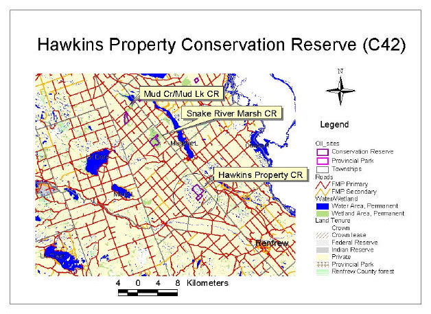
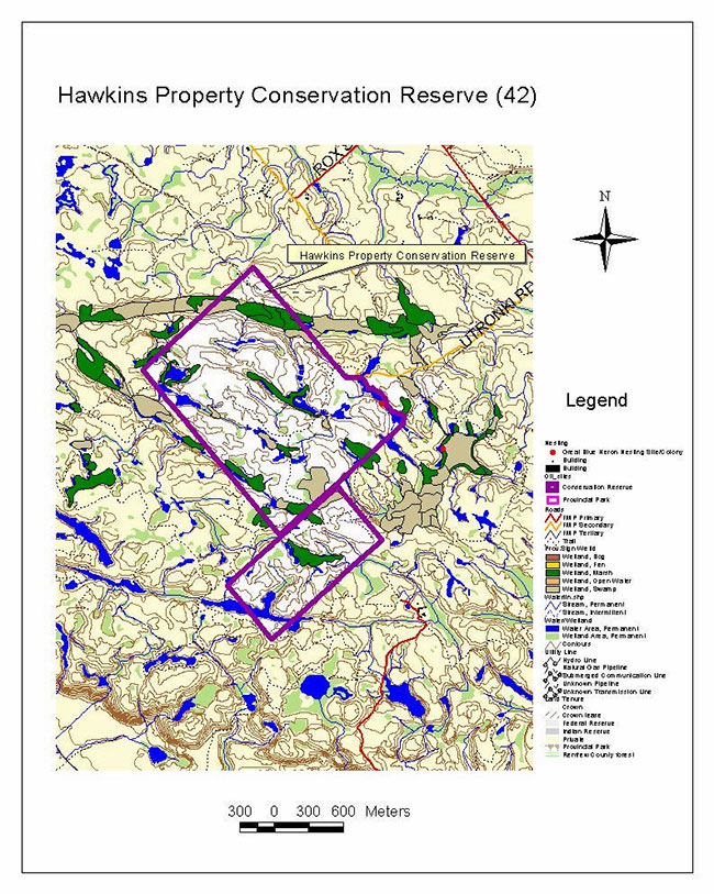
Figure 2: Site Map
1.1 Background information
| Name | Hawkins Property (Proposed) Conservation Reserve |
|---|---|
| Ecological Site Region / Site District | 6E-16 (formerly 5E-12) |
| OMNR Administrative Region/District/Area | Southcentral Region / Pembroke District / Madawaska River Area |
| Total Area (hectares) | 332 ha |
| Regulation Date | Pending |
| First Nations Interests | Algonquins |
| OBM map sheets (2) | 10 18 3500 50450 10 18 3550 50450 |
| UTM Coordinates | 10 18 355500 E / 5047500 N / (NAD 83) |
1.2 Representation/targets
Earth science representation:
According to the Earth Science report by Duba & Frey (2001), the bedrock geological features of the proposed reserve have regional significance in their representation of certain components of the Bancroft Terrane, while the surficial geology is locally significant.
Life science representation:
While the site contributes to the life science representation of ecological Site Region 6E-16 (formally known as 5E-12), it primarily serves to protect the Crown land portion of a Provincially Significant Wetland (PSW) – Muskrat River Complex (#3).
Cultural resources representation:
A nearby portage route known by local residents as the Champlain Trail was used by both Aboriginal peoples and by fur traders/courier-du-bois. This route began below Portage du Fort on the Ottawa River and bypassed large rapids (Rocher Fendu) by following the water corridor along Coldingham, Olmstead and Muskrat Lakes. The portage continued across again to the Ottawa River below Morrison’s Island. An astrolabe thought to be Samuel de Champlain’s was found at Green (Astrolabe) Lake, a few kilometers from the proposed conservation reserve (Price & Kennedy, 1961).
The remains of an old abandoned homestead are still visible in the form of foundations, domestic garden plants, stone piles and refuse areas. When the property was originally purchased with ARDA funding in 1973, red pine seedlings were planted in the abandoned fields throughout the site.
1.3 Survey information
This section provides an overview of the inventories completed, their level of detail and any further inventory work required.
| Survey Level | Earth Sciences | Life Sciences | Cultural | Recreational | Other |
|---|---|---|---|---|---|
| Reconnaissance | Frey and Duba, (2001). | Moore & Hiscock (2001); Merchant and Hiscock (2001); Jessup & Davis (2000). Life Science Check -sheet (Merchant 2002) |
None known | Moore & Hiscock known (2001); Moore , Davis & Hiscock (2001); Coulson, 2002. Recreation Inventory Report (Hiscock, 2002) |
Wetland Evaluation (Pollard Environmental Consulting- 1994); Final Technical Reports: Highway 17 (Dillon Consulting Limited- 1995); |
| Detailed | No | No | No | No | No |
| Requirement | No | Yes | Yes | No | No |
2.0 Values to be protected
This section provides a description of the key natural heritage values of the site and their condition relative to past and present resource use and management activities. It also addresses the sensitivity of these values to future land use and management activities.
This proposed conservation reserve is located within Hills (1959) ecological Site District 6E-16 (formerly 5E-12). Values include earth science, life science and recreational features.
2.1 Earth science
Earth science values are focused on features (bedrock and surficial) that represent the chronology of earth history in the province (Davidson 1981).
According to the Earth Science report by Duba & Frey (2001), the dominant rock types of the proposed Hawkins Property Conservation Reserve are mafic gneiss of probable metavolcanic protolith, pyroxene syenite and late granite pegmatite dikes of the Bancroft Terrane in the northeastern part of the Central Metasedimentary Belt of the Proterozoic Grenville Province.
Within Ontario’s protected areas system, the bedrock geological features of the proposed reserve have regional significance in their representation of the metavolcanic supracrustal and undersaturated felsic plutonic components of the Bancroft Terrane (Duba & Frey, 2001).
The surficial geology is locally significant. The till, ice-contact stratified drift of moraine crest and glaciofluvial deposits are typical components of the Wisconsinan Stage of the Quaternary Era in the southeastern Ontario (Duba & Frey, 2001).
2.2 Life science
Representation:
The Hawkins property is located in the Muskrat Lake Ridges, an area of raised Precambrian bedrock surrounded by the Ottawa Valley Clay Plains. (Chapman and Putnam, 1984). The tops of these ridges were not covered with silt and clay as was the surrounding bottom of the Champlain Sea, but with shallow sand and gravel. The gently rolling topography here varies from exposed bedrock knobs to grassy openings, mixedwoods on fresh slopes, and low er-lying marshes, swamps and ponds. Wetlands are usually long and narrow, running in an east-west direction. Soils range from sandy to silty to organic. The Hawkins Property is abandoned farmland, acquired in 1973, and is one of the few pieces of Crown land in the mainly agricultural Ecodistrict 6E-16 (formerly 5E-12).
The forested uplands appear to be of fire origin, and are early to mid-successional mixedwoods on rich fresh coarse loamy to silty soils. Most of these are poplar stands succeeding to red maple, white spruce and balsam fir (ES17 and 18 in the Forest Ecosystem Classification for Central Ontario (Chambers et al, 1996)). Associated species are diverse, with most of the mid-tolerant Great Lakes-St. Lawrence tree species forming part of the overstory and understory in different areas including red oak, white elm, cherry trees, basswood, ironwood, white ash, white pine, and white cedar. Understory vegetation of these areas is typical of medium to rich mixedwoods. Notably lacking are the tolerant hardwood species, sugar maple, yellow birch, beech and their coniferous associate, hemlock. Conifers are dominant only in red pine plantations and in a few small low-lying areas of white cedar. The poplar and birch are beginning to give way to disease and blow down in many areas, creating an abundance of snags and downed woody debris.
Approximately 20% of the site is covered by wetland complexes (two wetland types-marsh and swamp). Part of the provincially significant Muskrat Lake Wetland Complex #3 lies within the boundaries. These wetlands provide Class 3 Moose aquatic feeding areas (Pollard Environmental Consulting, 1994) as well as habitat for beaver, mink, otter muskrat, small fish, minnows and turtles.
The open areas are either very shallow/exposed bedrock openings in the woods, or small grassy areas with introduced species (e.g. rhubarb and currants). Some abandoned fields have been planted with red pine.
While the site contributes to the life science representation of ecological Site Region 6E-16 (formally known as 5E-12), it primarily serves to protect the Crown land portion of a Provincially Significant Wetland (PSW) – Muskrat River Complex (#3).
Condition:
The nature and age of the stands indicate that they are of fire origin in the 1920's. The property was partly cleared, and introduced species remain: rhubarb, currants, spiraea, thistles, grasses and vetch. Red pine was planted in 1974 and chemically tended in 1974 and 1992/3. Those plantations within the reserve are to be abandoned. A number of old roads and ATV trails enter the area, but none traverse it due to the wetlands. The forests and wetlands show little human disturbance.
A cottage property abuts on the eastern boundary, but otherwise the proposed reserve is in the middle of a larger area of natural landscapes. The natural gas pipeline crosses the northern corner, possibly providing wildlife with a corridor to other natural areas, as there is an abundance of wildlife sign in this isolated natural area.
Diversity:
The area is highly diverse, with varying sizes and types of ecosites well interspersed including upland forests, open areas, wetlands, ponds and creeks. The intolerant hardwood stands give indications of succeeding to a variety of forest types. Open areas within the forest are bedrock knobs, with juniper and lichen dominating. The abandoned field, once containing a house and yard, add to the diversity: grasses dominate, and other introduced species are common. Food sources include: highbush cranberry, alternate-leaved dogwood, currants and raspberries. Wetlands, creeks and ponds are of varying sizes.
Wildlife species noted include moose, beaver, raccoon, muskrat, Canada geese, great blue heron, pileated woodpecker, rose-breasted grosbeak, and numerous songbirds.
Ecological considerations:
The proposed reserve is higher in elevation than surrounding agricultural land, and is protected from agricultural runoff. The ecosites observed are not particularly susceptible to damage by trampling. The network of trails already present gives this proposed reserve good potential for recreational uses.
Special features:
The proposed reserve contains the best representation of the upland mixedwood forests of the Muskrat Lake Ridges, a physiographic region recognized by Chapman and Putnam (1984).
Most of the upland ecosites are poplar stands, succeeding to red maple, white spruce and balsam fir with numerous species forming the under and overstories. Notably lacking in the understory of these forests are the tolerant hardwood species of sugar maple, yellow birch, beech and hemlock. Poplar and birch are beginning to give way to disease, creating an abundance of snags and tree cavities (Merchant, 2002). These forests provide habitat for wildlife species such as deer, moose, bear, ruffed grouse, woodcock, wild turkeys and hare. This dense cover is considered locally significant to wildlife during the winter months (Pollard Environmental Consulting, 1994). A deer wintering area can be found in close proximity to the proposed reserve.
A large population of painted turtles (15) was noted in the 1994 wetland evaluation of the site and a Blandings turtle was observed during a field visit in the spring of 2001. Waterfowl also utilize the small ponds and the potential for breeding, staging or migration habitat is present, however the significance is unknown (Pollard Environmental Consulting, 1994). An active heronry is also found on the site (current status to be confirmed). Numerous songbirds and migratory birds, five species of frogs and toads, and various species of dragonflies and butterflies were observed during field visits.
Although wetland vegetation is abundant and diverse, there are no known provincially significant plant species present on the site. A large population of two types of orchids (Cypripedium reginae (Queen’s lady slipper), and Spiranthes sp. (Ladies tresses sp.) were noted during the wetland evaluation assessment in 1994.
Significance:
The Hawkins Property is a locally significant natural area and part of a provincially significant wetland. It is a representative site of poplar mixedwoods.
2.3 Cultural values
None identified on site, although known to be present in surrounding area.
2.4 Recreational values
The Hawkins Property site is a popular hunting area. It is used frequently by local residents for big game species such as deer (some moose and bear), as well as the smaller game species of hare, ruffed grouse and wild turkey.
The network of trails and old roads within the site allows for the current use of all terrain vehicles (ATV), four wheel driving and horseback riding as well as hiking, mountain biking and trail bike riding. There are also abundant opportunities for cross-country skiing, snow shoeing and snowmobiling. A "TOP" (Trans-Ontario Provincial) trail passes within approximately 0.5 km of the north, east and south sides of the proposed conservation reserve.
The site’s easy access provides for many additional recreation opportunities such as landscape viewing, natural heritage appreciation and bird watching, which are presumed to be underutilized.
3.0 Management guidelines
3.1 Land tenure
Background:
Originally a farm homestead, the proposed Hawkins Property Conservation Reserve was purchased in 1973 through funding provided by the Agriculture Rehabilitation Development Act (ARDA). It comprises the Crown land portion of a provincially significant wetland complex. The site is located in Lot 3, Concession 2, part of Lot 4, Concession 1 and parts of Lots 4, 5 and 6, Concession 1 and 2 in Bromley Geographical Township.
The unopened road allowances within the property are municipally owned and are not considered part of the proposed reserve.
Completely surrounded by private land, the proposed Hawkins Property Conservation Reserve is accessed from Trans-Canada Hwy 17 by two-wheel drive vehicles via a municipal road (Utronki). This road is not open during the winter months. A TransCanada Pipeline easement is located the northeastern corner of the property, and a "TOP" (Trans Ontario Provincial) s nowmobile trail passes within approximately 0.5 km of the north, east and south sides of the proposed reserve, providing additional access.
Within the property itself, old roads and numerous ATV trails transect the site providing many for recreational opportunities. Local residents commonly use these seasonal trails and the site is not presently known to be a direct tourism destination.
There are currently no land use permits (LUP's) associated with this site, however, Crown land fur harvesting occurs and the site is part of a commercial baitfish harvesting area.
There were no significant issues raised during public consultation and only one response received which concerned TransCanada Pipeline easement rights in the northern corner of the proposed reserve.
Guideline:
Sale of Crown lands within the proposed conservation reserve is not permitted, with the exception of some types of minor dispositions in support of existing uses (e.g., Land Use Permits or Licenses of Occupation). Renewals of existing land use permits are permitted. New leases or land use permits will be allowed for approved activities (see Appendix 1).
Leasing of Crown lands within the proposed conservation reserve for the development of private camps is not permitted. Leasing of Crown lands to new commercial outfitting services, outpost camps, resort or lodges can be considered during future planning, however, it is very unlikely that such use will be proposed in this site, due to its small size and unsuitability for such activities. Currently, there are no "remote" based tourism lodges or camps on Crown land with exclusive tenure to an area in Pembroke District. There are numerous lodges, resorts, motels and cottages on private land which house tourists who use nearby Crown land and lakes for recreation activities (Yaraskavitch, ca. 1997-98).
Lands that would enhance the proposed conservation reserve, by incorporating more of the provincially significant wetland, or by providing more public access to the site, may be purchased if funding and/or contributing partners become available. Should the municipality be willing, the acquisition by the Crown of the unopened municipal road allowances within the proposed reserve would benefit the consolidation and long term protected area management of this property.
Unauthorized occupations of lands within the proposed conservation reserve will be handled in accordance with approved policy, and any required structural removal will be undertaken at the owner’s expense.
3.2 Existing/Proposed development
Background:
The existing network of old roads and ATV trails provides this proposed reserve with many opportunities for recreational use. Potential exists for the development of interpretive, self-guiding nature trails on existing corridors. The ecos ites observed are not particularly vulnerable to damage by trampling however the bedrock exposures of the proposed conservation reserve are susceptible to graffiti, uncontrolled sampling and unplanned disturbances (appropriate cautionary warnings or controls should be implemented if increased access is promoted). These activities however, may conflict with hunting activity during certain times of the year.
Guideline:
New trails are discouraged, however, they may be considered when compatible with other recreational uses, the maintenance of environmental integrity, and the requirements of Procedural Guideline B – Test of Compatibility (Appendix 1). Any new trails will be designed to avoid those areas identified as sensitive to disturbance, or supporting provincially, regionally, or locally important plant species.
Construction of minimal facilities for the development of recreational and/or educational purposes may be considered in the future if there is a demonstrated demand for such facilities. A more detailed management plan would be required at that time.
All provincial policies that guide development (i.e. water hazard management, wetlands) are applicable in conservation reserves as on Crown land.
3.3 Recreational activities
Background:
The Hawkins Property site is a popular hunting area, frequently used by local residents for big game species such as deer and bear, and small game species such as hare, ruffed grouse, wild turkeys and waterfowl.
The network of trails within the site allows for the current use of ATV's, four wheel driving and horseback riding. It is unknown to what degree the area is actually being used for hiking or walking, backpacking and/or camping, mountain biking or trail bike riding, however the potential exists for these opportunities as well. Snowmobiling has become a very significant winter activity in eastern Ontario and its importance to the local economy is increasing (Dillon Consulting, 1995). One of the "TOP" (Trans -Ontario Provincial) trails passes within approximately 0.5 km of the north, east and south sides of the proposed conservation reserve. Although there are no known groomed trails within the proposed reserve, there are abundant opportunities for snowmobiling on the numerous trails and old roads within the site. In the same vein, there is enjoyment of some cross-country skiing and snow shoeing within the site, although to what extent, is unknown.
Although primarily used for hunting and trail-riding, the site’s easy access provides for many additional eco-tourism opportunities. Day-use activities such as wildlife viewing, natural heritage appreciation, birdwatching, photography, nature study and interpretation (opportunities presumed to be underutilized); all in relative solitude could easily be a future draw to the site.
Guideline:
Most recreational activities that have traditionally been enjoyed in this area can continue provided they pose little threat to the natural ecosystems and features protected by the proposed conservation reserve. Permitted uses include such things as wildlife viewing, hiking, hunting, horseback riding, snowshoeing, cross-country skiing, exploring and fishing. Activities such as snowmobiling and the use of all-terrain vehicles (ATV's) will generally be permitted to continue where they do not adversely affect the values being protected.
It must be noted that mechanized travel (e.g., ATV's, snowmobiles) is permitted only on existing roads and trails. Off-trail mechanized travel is permitted only for the direct retrieval of game.
3.4 Commercial activities
Background:
Crown land fur harvesting occurs within the site for beaver, mink, otter and muskrat and the proposed conservation reserve is also part of a commercial baitfish harvesting area.
The proposed reserve is not part of a Bear Management Area (BMA), nor are there any outpost camps, resorts, outfitting services or commercial food harvesting (e.g., wild rice) operations occurring within the site.
Guideline:
Commercial activities such as commercial fishing and fur harvesting are permitted in conservation reserves provided they do not impact the natural heritage values for which the area is established. Existing bait fishing use and Crown land fur harvesting are permitted to continue within the Hawkins site unless there are demonstrated conflicts. New baitfish and fur harvesting operations can be considered subject to the test of Compatibility (see Appendix 1). No new fur harvesting cabins are permitted. New authorized non-resident bear hunting operations are not permitted, however new outpost camps, resorts, outfitting services or commercial food harvesting operations may be considered within the proposed reserve. It is unlikely that these activities would be proposed for the Hawkins property.
Mineral exploration and mining are not permitted within the proposed Hawkins Property Conservation Reserve.
Conservation reserves do not permit commercial forest harvesting (thus new resource access roads within the mandate of OMNR), hydroelectric power development, the extraction of aggregate, peat, soils, or other industrial uses. (Public Lands Act, Ontario Regulation 805/94).
Other new commercial activities must meet the requirements of Procedural Guideline B – Test of Compatibility, Appendix 1. New transmission lines (e.g. power or communications), pipelines, highways and road corridors are discouraged through existing planning processes.
3.5 Aboriginal interests
Background:
The proposed conservation reserve is located within the Algonquin Nation land claim area.
Records indicate that a wide range of Aboriginal cultures have utilized this general area in the past (Jessup & Davis, 2000). There are no known archeological sites within the proposed Hawkins Property Conservation Reserve itself, however there are Native artifact sites found within 20 km of the property (OMNR, 2002). These sites reflect a span of 5000 to 6000 years of occupation (Archaic; Early, Middle and late Woodland; early Historic) (Dillon Consulting, 1995). As mentioned previously, a nearby portage route known as the Champlain Trail was used by both aboriginal peoples and by fur traders and courier-du-bois (Price & Kennedy, 1961).
Guideline:
The Ministry of Natural Resources and the Algonquin Nation are developing a protocol to guide discussions on a number of land use matters, including implementation of the Ontario’s Living Legacy Land Use Strategy. The Hawkins Property site has unique values that would benefit from protection at this time. The values at this site may be expanded in the future with the identification of other unique values through the protocol consultation process with the Algonquins/ Algonkians. Hunting and fishing are permitted uses in proposed conservation reserves.
3.6 Natural resource stewardship
3.6.1 General
This proposed conservation reserve will be managed with an emphasis on ensuring that the natural ecosystems and processes of the conservation reserve are not negatively affected by current and future activities. Therefore, applications for specific uses will be carefully studied and re viewed. The Ministry, partner organizations, and/or the proponents may undertake such studies.
3.6.2 Vegetation
Background:
The proposed Hawkins Property Conservation Reserve’s landscape is highly diverse, ranging from exposed bedrock knobs to grassy openings and from mid-successional mixed forests to lower lying marshes, swamps and ponds.
Almost entirely encompassed by a larger PSW, approximately 20% of proposed reserve is covered by wetland complexes (two wetland types-marsh and swamp). The stable, gently sloping shorelines of these wetlands provide Class 3 Moose aquatic feeding areas. Potential for waterfowl breeding, staging or migration habitat is present, however the significance is unknown (Pollard Environmental Consulting, 1994).
The Hawkins Property is interspersed with wetland complexes including swamps and small ponds with marshes. These wetland areas tend to be long and narrow and run in an east-west direction. Although wetland vegetation is abundant and diverse, there are no known provincially significant plant species present on the site. A large population of two types of orchids (Cypripedium reginae (Queen’s lady slipper), and Spiranthes sp. (Ladies tresses sp.) however, were noted by Pollard Environmental Consulting during the wetland evaluation assessment (1994).
The remains of an old abandoned homestead gives rise to many introduced species commonly found in meadows, fields and disturbed sites including garden plants such as tiger lilies, sedum and honey locust. Wildlife food sourc es include high-bush cranberry, alternate-leaved dogwood, currants and raspberries. When the property was originally purchased with ARDA funding in 1973, red pine seedlings were planted in the abandoned fields throughout the site.
The nature and age of the forested uplands indicate that they are of fire origin from the 1920's. Most of these are poplar stands succeeding to red maple, white spruce and balsam fir with numerous species forming the understory and overstory. Notably lacking in the understory of these mixedwoods are the tolerant hardwood species of sugar maple, yellow birch, beech and hemlock. Poplar and birch are beginning to give way to disease; creating an abundance of snags and tree cavities (Merchant, 2002). This dense cover is considered locally significant to wildlife during the winter months (Pollard Environmental Consulting, 1994).
The proposed reserve is situated in the middle of a larger natural landscape area. The site is higher in elevation than surrounding agricultural land, therefore protected from agricultural runoff.
Guideline :
As stated in the Ontario’s Living Legacy Land Use Strategy (1999), the red pine plantation on the eastern boundary of the site will not be included in the conservation reserve.
The proposed conservation reserve will be managed by allowing natural ecosystems, processes and features to operate normally, with minimal human interference or alteration.
Conservation reserve policy states that forest fire protection will be carried out in the proposed reserve as on surrounding public lands, unless it is determined through management planning that another approach should be undertaken. Pembroke District MNR has a policy of aggressively suppressing all fires. The MNR would appropriately respond to any fire as per policy or municipal agreements at any such time, with a "light on the land" approach (i.e., no bulldozers, no camp construction, minimal cutting).
Programs may be developed to control forest insects and diseases in the proposed conservation reserve where these threaten significant natural heritage, aesthetic, or economic values. Where control is desirable, it will be directed as narrowly as possible to the specific insect or disease. The methods selected will be subject to the requirements of Procedural Guideline B – Test of Compatibility (Appendix 1).
Any habitat alterations would be reviewed on a case by case basis, with consideration given to the protection of natural heritage values, OMNR's environmental assessment responsibilities and provincial conservation reserve policy.
Invasive species which are deemed to threaten the natural heritage values of the proposed conservation reserve will be managed using acceptable and approved controls which protect natural heritage values and are subject to Procedural Guideline B – Test of Compatibility (Appendix 1).
The Ministry of Natural Resources will continue to work with municipalities and private landowners to protect private land portions of the provincially significant wetland by way of land tax incentives, co-stewardship opportunities and through municipal land use planning. Landowners with property in a provincially significant wetland may be eligible for the Conservation Land Tax Incentive Program, providing they meet the program criteria and agree to protect the natural heritage values of their property. Protection of the wetland can also be promoted by municipal consideration of the Provincial Policy Statement and Planning Act within planning documents and through development review.
3.6.3 Wildlife management
Background:
The mid-successional mixed forests of the proposed Hawkins Property Conservation Reserve provide habitat for large game species such as deer, moose, bear as well as upland species such as hare, ruffed grouse, woodcock and wild turkeys (which have been recently re-introduced into the area). A deer wintering area can also be found approximately 14 km northwest of the proposed conservation reserve (OMNR, 2002b).
Interspersed with wetland complexes, the site provides habitat for small aquatic mammals such as beaver, mink, otter and muskrat as well as small fish, minnows and turtles. A large population of painted turtles (15) was noted in the 1994 wetland evaluation of the site (Pollard Environmental Consulting, 1994) and a Blanding’s turtle was observed during a field visit in the spring of 2001. Waterfowl (e.g. wood ducks, mergansers, teal, Canada geese) utilize the small ponds and marshes and an active heronry is also found on the site (current status to be verified) (Pollard Environmental Consulting, 1994). Evidence of porcupines and raccoons as well as numerous songbirds and migratory birds, five species of frogs and toads and many species of dragonflies and butterflies were observed during field visits. In addition one unidentified raptor was sighted.
The Hawkins Property site is frequently used by local residents for hunting small and large game species and waterfowl. Crown land fur harvesting occurs within the site and the proposed conservation reserve is also part of a commercial baitfish harvesting area.
Although primarily used for hunting and trail riding, the proposed reserve also provides many additional recreational opportunities. Day-use activities such as wildlife viewing, natural heritage appreciation, birdwatching, photography, nature study and interpretation (opportunities presumed to be underutilized); all in relative solitude could easily be a future draw to the site.
Guideline:
Hunting within the proposed conservation reserve may continue and will be guided by the relevant Ontario hunting regulations. Although bait-fish harvesting and Crown land fur harvesting currently exist in the proposed reserve, new bait-fish harvesting operations and commercial fur harvesting operations could be considered if necessary, subject to the requirements of Procedural Guideline B – Test of Compatibility (Appendix 1). Fur harvesting and bait-fishing would be managed through the current licencing system.
Activities such as nature appreciation, photography and wildlife viewing are all permitted uses.
Any habitat alterations would be reviewed on a case by case basis, with consideration given to protection of natural heritage values, OMNR's environmental assessment responsibilities and provincial conservation reserve policy.
Invasive species which are deemed to threaten the natural heritage values of the proposed conservation reserve will be managed using acceptable and approved controls which protect natural heritage values while being subject to Procedural Guideline B – Test of Compatibility (Appendix 1).
3.7 Cultural resource stewardship
Background:
The protection and conservation of cultural heritage resources is governed by the Ontario Heritage Act and administered by the Ministry of Culture. Cultural features (e.g., abandoned homestead) have been identified on site while archeological and historic values have only been identified in the surrounding area.
Guideline:
Interested partners with the appropriate qualifications would be allowed to undertake inventories and studies of the area, consistent with Procedural Guideline C - Research Activities in conservation reserves (Appendix 2). The specific location of cultural heritage sites will be kept confidential to protect the resources.
3.8 Client services
Background:
No services or facilities are presently provided within the site boundaries. Potential exists however, for the development of interpretive, self-guiding nature trails (including displays, brochures etc.) which could highlight the natural heritage and geology of the area. At the present time, a brief information fact sheet for the proposed Hawkins Property Conservation Reserve developed during the public consultation phase in 1999 is available to the public through the Pembroke District MNR office or via the internet at www.ontarioslivinglegacy.com (link no longer active).
Guideline:
Given the present focus on low key management, client information will be provided on an inquiry-only basis and will deal with the basic level of information with respect to access, natural heritage appreciation, recommended activities, and boundaries.
3.9 Research
Background:
Pollard Environmental Consulting completed the wetland evaluation of the PSW, Muskrat River Complex (#3) in 1994. As mentioned, the proposed Hawkins Property Conservation Reserve is almost entirely encompassed by this wetland. As part of the responsibilities associated with the regulation of the proposed reserve, three additional reports were completed and can be found on file with the Ministry of Natural Resources at the Pembroke District office. They are as follows:
- Natural Heritage Area – Life Science Checksheet (Merchant, 2002)
- Recreation Resource Inventory Report (Hiscock, 2002)
- Earth Science Report (Frey & Duba, 2001)
Guideline:
A detailed geological inventory of the proposed Hawkins Property Conservation Reserve is not warranted unless the Ministry intends to promote more visitation and eco-tourism. Future inventory work should focus on the identification of additional components of the Bancroft Terrane that may occur on the property (Frey & Duba, 2001).
As well, cultural/historical inventories should be conducted within the site in order to determine the extent of Native archeological features.
In general, non-destructive research by qualified individuals will be encouraged to:
- provide a better understanding of the natural values protected by the proposed Hawkins Property Conservation Reserve
- monitor impacts of recreational use of the site
- advance protection, planning and management of the proposed conservation reserve
Research proposals and activities must follow Procedural Guideline C – Research Activities in Conservation Reserves (PL. Procedure 3.03.05) (Appendix 2).
All research programs will require the approval of the Ministry of Natural Resources as will the removal of any natural or cultural specimen. The establishment of permanent plots, observation points or facilities must also be approved and be compatible with the conservation reserve protection objective. Any site disturbed by research activities must be rehabilitated as closely as possible to its previous state. The researcher will submit copies of reports, publications, theses and results to the OMNR Madawaska Area Supervisor in Pembroke District.
3.10 Marketing
Background:
There has been no direct marketing of the proposed Hawkins Property Conservation Reserve to date. Promotion and information about this site has been distributed primarily through the Ontario’s Living Legacy planning process. This includes recent public consultation regarding the proposed regulation and boundary refinement of the site and through the Living Legacy website at www.ontarioslivinglegacy.com (link no longer active).
Guideline:
Although potential may exist for additional eco-tourism opportunities, intensive marketing activity to increase recreational use of the proposed Hawkins Property Conservation Reserve is not required at this time. The fact sheets concerning this proposed conservation reserve will continue to be available to inform the public about the special values of this area its role in Ontario’s protected area system.
4.0 Implementation
Administrative responsibility for the proposed Hawkins Property Conservation Reserve lies with the Madawaska Area, Pembroke District office of the Ministry of Natural Resources.
The district office will continue with the custodial care of the proposed conservation reserve and will also seek out partnerships where appropriate. Implementation of this Statement of Conservation Interest will primarily involve monitoring activities to ensure adherence to the management guidelines.
Implementation priorities include:
- consultation with Algonquin First Nation representatives and communities, as a basis of proceeding with final boundary refinement and regulation of this proposed conservation reserve
- updating this SCI upon final regulation as a conservation reserve
- encourage the undertaking of additional life science, geological, recreational and/or cultural/historical inventories, assessment and research to provide a better understanding of the natural values protected by the proposed Hawkins Property Conservation Reserve
- monitor impacts of recreational use upon the site
- examining the potential opportunities of acquiring additional lands adjacent to or in close proximity of the proposed reserve as well as unopened municipal road allowances
- examining the potential for the development of interpretive, self-guiding nature trails or displays
- providing client services (e.g. brochure or fact sheet) at nearby MNR Offices
- proceeding with minor development (e.g. trail maintenance, signage, resource management activities, etc.) as funding permits
- ongoing education of resource users with respect to resource and land stewardship values (e.g., brochures, engaging in partnership opportunities, working with adjacent landowners, municipalities, etc.) in order to provide long term recreational opportunities and maintain the ecological integrity of the site
5.0 Review and revision of the statement of conservation interest
The proposed Hawkins Property Conservation Reserve’s Statement of Conservation Interest will be reviewed on an ongoing basis.
If changes are required in the Statement of Conservation Interest, they will occur through a standard process of minor and major amendments. Minor amendments will be processed in a relatively informal manner and will require the approval of the Area Supervisor. These amendments will deal with uses and activities that do not affect any of the policies in this SCI, such as new uses and/or activities that are consistent with existing uses.
Uses and/or activities that were not anticipated in the approved SCI and which have the potential to have a negative impact on the values of this proposed conservation reserve will require a major amendment. This will include an opportunity for public comment and input, and will require the approval of the District Manager and Regional Director.
References
Chambers, Brenda. Legasy, Karen. and Bentley, Cathy V. 1996. Forest Plants of Central Ontario, Lone Pine and Queen’s Printer for Ontario.
Chapman L.J. and D.F. Putman. 1984. Physiography of Southern Ontario, Third Edition, Ontario Geological Survey of Special Volume 2.
Chapman L.J. and D.F. Putman. 1984. Physiography of Southern Ontario, Ontario Geological Survey Map P.2715, Ontario Ministry of Natural Resources. Scale 1:600,000.
Davidson R. J. 1981. A Framework for theConservation of Ontario’s Earth Science Features. Ontario Ministry of Natural Resources, Toronto.
Dillon Consulting Limited. March 7, 1995. Final Technical Reports: Highway 17 - Haley Station to Meath Hill Environmental Assessment and Route Planning Study.
Frey, Edward and Duba, Daria. January, 2002. Earth Science Report – C42 Hawkins Property Conservation Reserve.
Jessup, Carol Ann and Davis, Mike G. January 2001. Recreation Inventory Report – Mud Lake/Mud Creek Conservation Reserve (C59), OMNR.
Hills, G. A. 1959. A ready reference to the description of the land of Ontario and its productivity. Ontario Department of Lands and Forests, Division of Research, Maple, Ontario.
Hiscock, N. March, 2002. Recreation Resource Inventory Report: Hawkins Property Conservation Reserve (C44), OMNR.
Merchant, Barb. February, 2002. Natural Heritage Area- Life Science Checksheet, Proposed Hawkins Property Conservation Reserve.
Noble T. W. 1983. Biophysiographic Analysis of Site Region 5E. Central (Algonquin) Region, Ontario Ministry of Natural Resource.
Ontario Ministry of Natural Resources. September 2000. Hawkins Property Conservation Reserve (C42) Fact Sheet.
Ontario Ministry of Natural Resources. February, 2002. Natural Resources Values Information System (NRVIS), Pembroke District.
Ontario Ministry of Natural Resources. July 1999. Ontario’s Living Legacy, Land Use Strategy, Ontario Ministry of Natural Resourc es, Peterborough.
Ontario Ministry of Natural Resources. 1983. Pembroke District Land Use Guidelines. Pembroke District, Algonquin Region, Ontario Ministry of Natural Resources.
Ontario Ministry of Natural Resources. 1987. (M. Davis- May, 2001).Pembroke District. Forest Resource Inventory Mapping (FRI).
Pollard Environmental Consulting. August 27, 1994. Muskrat River Wetland # 3 Wetland Evaluation, Ontario Ministry of Natural Resources.
Price, Mrs. Carl and Kennedy, Clyde C. 1961. Notes on the History of Renfrew County for the Centennial 1961. Renfrew County Council, Pembroke, Ontario, for the Centennial 1961.
Yaraskavitch, Joe. Circa 1997-98. Pembroke District-Resource Based Tourism (excerpts from), OMNR.
Appendix 1: Procedural Guideline B – Land Uses – Test of Compatibility (PL procedure 3.03.05)
The conservation reserve policy provides broad direction with regard to the permitted uses. The policy provides only an indication of the variety of uses that will be considered acceptable in conservation reserves. The only caution is that "any new uses, and commercial activities associated with them, will be considered on a case by case basis, and, they must pass a test of compatibility to be acceptable."
What does a 'test of compatibility' mean? An examination of this must start from the premise of why an area is set aside – specifically, its representative natural heritage values. Criteria are then identified to guide compatibility considerations. These criteria apply to the long-term acceptability of both existing uses and new uses.
-
Conformity to SCI/RMP: SCI describes values for which an area has been set aside and the range of appropriate uses that will be permitted in the area. SCI may also speak to the acceptability of other 'new' us es currently not occurring in the area.
The first 'test' is: "do proposed new land uses and/or commercial activities conform to the direction of the SCI/RMP for the conservation reserve? Would the new use(s) depart from the spirit of appropriate indicator land uses in the SCI/RMP?"
- Impact Assessment: If the proposed use(s) pass test 1 it is important to determine their impact on the area before they are approved. This should include the following:
- Impact on natural heritage values: "will the new use(s) impact any natural values in the area? If so how and to what degree? Is it tolerable?"
- Impact on cultural values: "will the new use(s) impact an historical or archaeological values in the area?"
- Impact on research activities: "will the new use(s ) affect research activities in the area?"
- Impact on current uses: "will the new use(s) have any negative impact on the array of current uses?"
- Impact on area administration: "will the new use(s) increase administrative costs and/or complexity?" (For example, the cost of area monitoring, security and enforcement).
- Impact on accommodating the use outside the conservation reserve: "Could the use(s) be accommodated as well or better outside the conservation reserve?"
- Impact on socio-economics of the area: "will the new use(s) affect the community (ies) surrounding the area in a positive or negative way?" (For example, will the new use make an area less remote thereby affecting a local tourism industry that is dependent on the area’s remoteness for its appeal?"
- Impact on area accessibility: "does the new use(s) give someone exclusive rights to the area or a portion of the area to the exclusion of other existing uses?"
Indicator uses for Conservation Reserves
Industrial activities
| Activity | Generic OLL Policy Permitted Existing |
Generic OLL Policy Permitted New |
Specific Application In Proposed Hawkins Property Conservation Reserve Exsiting | Specific Application In Proposed Hawkins Property Conservation Reserve New |
|---|---|---|---|---|
| Commercial timber harvest | No | No | No | No |
| Cutting of trees by leaseholders and property owners for fuelwood and small-scale uses | Maybe | Maybe | Maybe | Maybe |
| Timber salvage/sunken log retrieval | Maybe | Maybe | Maybe | Maybe |
| Mineral exploration | No | No | No | No |
| Mining | No | No | No | No |
| Extraction of peat, soil, aggregate, other materials | No | No | No | No |
| Forest renewal | Maybe |
Maybe |
Maybe |
Maybe |
| Hydro power generation | No | No | No | No |
| Communications corridors | Yes | No |
Yes | No |
| Energy transmission corridors | Yes | No |
Yes | No |
| Transportation corridors | Yes | No |
Yes | No |
| Resource access roads | Maybe |
Maybe |
Maybe |
Maybe |
| Private access roads | Yes | No |
Yes | No |
Recreation activities
| Activity | Generic OLL Policy Permitted Existing |
Generic OLL Policy Permitted New |
Specific Application In Proposed Hawkins Property Conservation Reserve Exsiting | Specific Application In Proposed Hawkins Property Conservation Reserve New |
|---|---|---|---|---|
| Sport fishing | Yes | Yes | Yes | Yes |
| Sport hunting | Yes | Yes | Yes | Yes |
| Facility development | Maybe | Maybe | Maybe | Maybe |
| Non-trail snowmobiling | Maybe |
Maybe |
Maybe |
Maybe |
| Non-trail ATV use | Maybe |
Maybe |
Maybe |
Maybe |
| Motorized boating | Yes | Yes | Yes | Yes |
| Camping | Maybe | Maybe | Yes | Yes |
Trails:
|
Yes | Maybe | Yes | Maybe |
| Private recreation camps | Yes |
No | Yes |
No |
Commercial activities
| Activity | Generic OLL Policy Permitted Existing |
Generic OLL Policy Permitted New |
Specific Application In Proposed Hawkins Property Conservation Reserve Exsiting | Specific Application In Proposed Hawkins Property Conservation Reserve New |
|---|---|---|---|---|
| Fishing | Yes |
Maybe | Yes |
Maybe |
| Bait-fish harvesting | Yes |
Maybe | Yes |
Maybe |
| Commercial fur trapping | Yes |
Maybe | Yes |
Maybe |
| Trapping cabin | Yes | No | Yes | No |
| Out-post camps/tourism facilities | Maybe |
Maybe |
Maybe |
Maybe |
| Commercial bear hunting (tourist operators) | Yes | No | Yes | No |
| Wild rice harvesting | Yes |
Maybe | Yes |
Maybe |
| Food harvesting | Maybe | Maybe | Maybe | Maybe |
Resource management activities
| Activity | Generic OLL Policy Permitted Existing |
Generic OLL Policy Permitted New |
Specific Application In Proposed Hawkins Property Conservation Reserve Exsiting | Specific Application In Proposed Hawkins Property Conservation Reserve New |
|---|---|---|---|---|
| Resource inventorying | Yes | Yes | Yes | Yes |
| Resource monitoring | Yes | Yes | Yes | Yes |
| Fire protection | Yes | Yes | Yes | Yes |
| Insect and disease | Maybe | Maybe | Maybe | Maybe |
| Featured species management | Maybe | Maybe | Maybe | Maybe |
Other activities
| Activity | Generic OLL Policy Permitted Existing |
Generic OLL Policy Permitted New |
Specific Application In Proposed Hawkins Property Conservation Reserve Exsiting | Specific Application In Proposed Hawkins Property Conservation Reserve New |
|---|---|---|---|---|
| Research | Yes | Yes | Yes | Yes |
| Collecting | Maybe |
Maybe |
Maybe |
Maybe |
| Food gathering | Yes | Yes | Yes | Yes |
| Land disposition | Yes |
Maybe |
Yes |
Maybe |
| Habitat management for wildlife | Maybe |
Maybe |
Maybe | Maybe |
Appendix 2: Procedural Guideline C – Research Activities in Conservation Reserves
Purpose
To encourage contributions to the goal of Conservation Reserves by:
- providing direction for research activities associated with conservation reserves
- establishing a process for the review and approval of proposals by researchers, which could have an impact on the values protected by the conservation reserve
Definition
Research means any investigation or study of the natural, cultural, social, economic, management or other features or characteristics of conservation reserves.
Guidelines
Research will be encouraged to provide a better understanding of the natural values protected by a conservation reserve and to advance their protection, planning and management. The Statement of Conservation Interest will define, for each conservation reserve, the key research issues, set out the parameters within which research may occur and identify research needs.
Applications and approvals
Researchers must apply in writing to the Area Supervisor for permission to conduct research. The request letter must contain a statement explaining why the proposed research should be undertaken in the particular conservation reserve in preference to another location.
Proposals will be reviewed and approved by the Area Supervisor, guided by the Statement of Conservation Interest prepared for each reserve (see Guideline A – Resource Management Planning) and using Guideline B – Land Uses – Test of Compatibility. Permission must be granted in writing, including any conditions to be met in conducting the research, prior to the undertaking of any research project .
Terms and conditions
Permission to conduct research under this policy will be valid for a period of 12 consecutive months from date of issue. Permission to continue a research project for additional periods of 12 months or less may be granted upon submission of a written request and progress report. The Ministry may require the posting of collateral to assure that the terms and conditions of granting permission are met.
The Area Supervisor may suspend or revoke permission at any time for failure on the part of the researcher to meet:
- The intent or conditions of this policy
- The requirements under the Public Lands Act, including all amendments, where applicable
- The requirements under any other Act or Regulations of Ontario or Canada, including those governing the taking, handling, storing, confining, fur harvesting, excavating and marketing any specimen, artifact, information or action (for example, scientific collector’s permit)
- The conditions and agreements specified in granting
Final report
The researcher will submit copies of reports, publications and theses following from the results of the project to the Area Supervisor.
Footnotes
- footnote[1] Back to paragraph If a new conservation reserve has been recently cut, companies have an obligation to proceed with renewal. It can be conducted where it will be of net benefit to the protected area and to, the greatest extent possible, it should be designed to replicate natural conditions.
- footnote[2] Back to paragraph The intent is to actively discourage these uses, but it is recognized that in some circumstances these will be no alternative; this will be determined through planning.
- footnote[3] Back to paragraph New private access roads, including additions to existing roads, will not be permitted except where there are previous commitments that were made prior to March 29, 1999. Such commitments will be subject to the completion of a public planning process.
- footnote[4] Back to paragraph Use may be permitted for the direct retrieval of game only.
- footnote[5] Back to paragraph Existing private recreation camps are eligible for enhanced tenure but not for the purchase of lands. A decision to grant enhanced tenure, or to transfer recreational camps will be addressed though a screening process.
- footnote[6] Back to paragraph Existing use permitted to continue, unless there are significant demonstrated conflicts. New operations can be considered, subject to the 'test of compatibility.'
- footnote[7] Back to paragraph Existing authorized tourism facilities can continue unless there are demonstrated conflicts. The operators of tourism facilities can apply to upgrade tenure from LUP to lease. New tourism facilities can be considered during planning for a conservation reserve.
- footnote[8] Back to paragraph Must be part of an authorized research project.
- footnote[9] Back to paragraph Sale of lands is not permitted with the exception of some minor types of dispositions where it does not detrimentally affect the values an area is intended to protect. Renewals of existing leases or land use permits are permitted. Requests for transfer of tenure will be considered in the context of the SCI. New leases or land use permits will be allowed for approved activities.
- footnote[10] Back to paragraph A specific policy was not identified in the OLL Land Use Strategy, although specific management prescriptions will be identified in the context of an SCI.