Hope Bay Forest Provincial Park Management Statement
This document provides direction on the management of Hope Bay Provincial Park.
Interim Management Statement
November 3, 1995
Approval statement
This Interim Management Statement will provide interim direction for the management of Hope Bay Forest Provincial Nature Reserve until such time as a comprehensive Park Management Plan is prepared.
This statement will provide the basis for the subsequent preparation of the Park Management Plan.
I am pleased to approve the Hope Bay Forest Provincial Nature Reserve Interim Management Statement.
Additional copies of this document are obtainable from:
Park Superintendent
MacGregor Point Provincial Park
R.R. #1
Port Elgin, Ontario N0H 2C0
Telephone: 1-519-389-9056
or
Park Planning Specialist
Southcentral Parks Zone, Parks Ontario
Ministry of Natural Resources
Midhurst, Ontario
L0L 1X0
Telephone: 1-705-725-7600
Signed by:
Norm Richards
Managing Director
Parks Ontario
Background information
| Name: | Hope Bay Forest Provincial Nature Reserve |
|---|---|
| Total Area: | 353 ha. (regulated) |
| Site District: | 6-14 |
| Regulation: | Ont. Reg. 45/85 |
| Proposed Class: | Nature Reserve |
| MNR Region: | Southern |
| MNR Parks Zone: | Southcentral |
Regional setting map scale 1:250,000
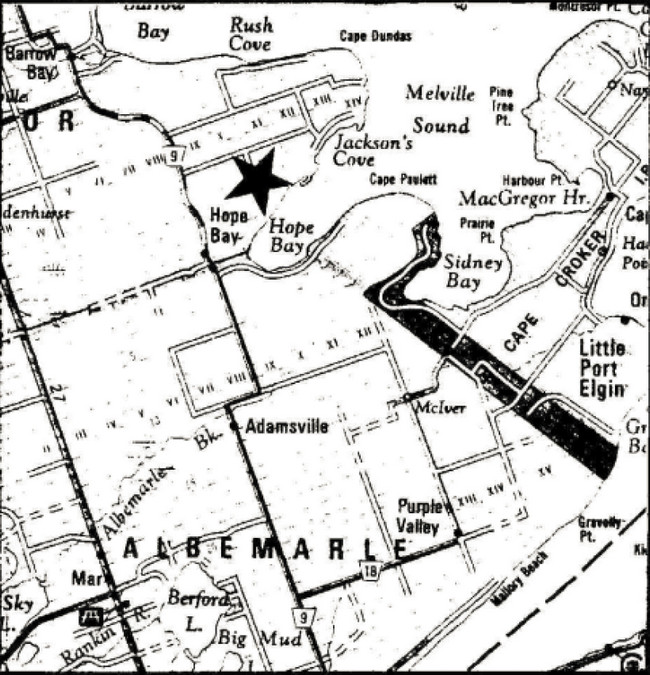
Enlarge: Regional setting map of Hope Bay Forest Provincial Nature Reserve
Targets
1. Life science representation (Provincial significance)
| Site type/landscape unit | Feature |
|---|---|
| Georgian Bay shore/escarpment complex inland rock pavement/wetlands | Backshore wet-dry, rock pavements, backshore cliffs, and mesic, forested talus slope rich escarpment plain forests, open cliffs, open talus, cobble beach, alvar fen, etc. |
2. Earth science representation (Provincial significance)
| Geological theme | Feature |
|---|---|
| Lower-middle Silurian | Limestone plain, shingle beaches, escarpment, wave cut and solution caves, flowstones, and potholes. |
3. Cultural resources representation
| Theme | Theme segment |
|---|---|
| Post contact tribes and bands. Early settlements. | Settlement of Bruce Peninsula. |
4. Recreational opportunities
| Day use | Car camping | Back country |
|---|---|---|
| Hiking (Bruce Trail) nature appreciation | n/a | n/a |
Inventories
| Level/type | Earth science | Life science | Cultural | Recreational | Other |
|---|---|---|---|---|---|
| Check sheet | Blachut, 1977 Kor, 1992 |
Cuddy, 1976 | n/a | n/a | n/a |
| Reconnaissance | n/a | n/a | (required) | n/a | n/a |
| Detailed | Kor, 1992 | Jalava, 1994 | n/a | n/a | n/a |
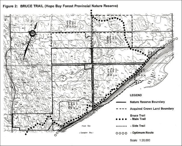
Figure 1: Hope Bay Forest Provincial Nature Reserve
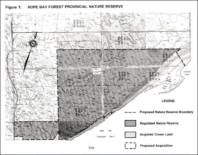
Enlarge: Map of Hope Bay Forest Provincial Nature Reserve
Management guidelines
I. Land tenure
A total of 353 hectares (872 acres) of land have been regulated under the Provincial Parks Act as part of Hope Bay Forest Provincial Nature Reserve. As shown in Figure 1, the park boundary includes part of Lot 2, Concession 9, part or all of Lots 2 to 6, Concession 10, part or all of Lots 3 to 6, Concession 11, and part of Lots 5 and 6, Concession 12, East of Bury Road (EBR), Township of Eastnor, County of Bruce. Acquired Crown lands adjacent to Hope Bay (Georgian Bay) are located within the proposed nature reserve boundary, but are not regulated.
87 hectares of land are presently rented out for grazing and crop growing under the authority of land use permit.
The park is located within the area of the Niagara Escarpment Plan and has been allocated among three land use designations: Escarpment Protection Area, Escarpment Natural Area and Escarpment Rural Area. The park is classified as a Nature Reserve in the Niagara Escarpment Parks and Open Space System.
Guideline:
Conditions permitting (see section IX.), acquired Crown lands located within the proposed nature reserve boundary may be regulated.
The issuance of the agricultural land use permit will be reviewed on an annual basis and during the preparation of a park management plan.
II. Land acquisition and disposal
Certain lands and road allowances within the proposed park boundary (see Figure 1) have yet to be acquired. Acquisition of these lands and road allowances would facilitate park management and protection of significant natural values.
Acquired Crown lands located outside the proposed nature reserve boundary presently include part of Lot 7, Concession 10, and Lots 7 and 8, Concession 11.
Guidelines:
Private lands located within the proposed nature reserve boundary may be acquired, subject to the availability of funding and the willingness of owners to sell. Acquired lands may eventually be regulated as part of the provincial nature reserve (see section IX.).
Subject to Niagara Escarpment Plan policy and other factors permitting (see section IX.), provincial lands adjacent to the provincial nature reserve which are declared surplus may be exchanged for private lands with a higher acquisition priority, or disposed of.
III. Existing and proposed development
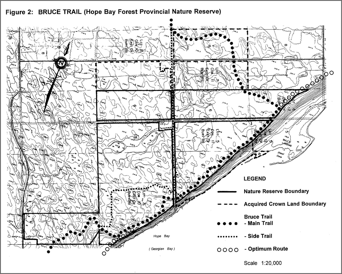
The Bruce Trail travels along the edge of the Niagara Escarpment through the Hope Bay Forest Provincial Nature Reserve. Existing facilities consist of signs identifying the property as a provincial nature reserve. A parking lot maintained by the local Bruce Trail Club exists outside of the nature reserve between Lots 1 and 2, Concession 10, within the community of Hope Bay. Aside from the Bruce Trail, there is no development within the nature reserve.
Guidelines:
The Bruce Trail will continue to be maintained by the Peninsula Bruce Trail Club.
Aside from the erection of signs (including interpretive panels), gates and fencing as required, no other development is proposed.
Construction of additional parking area and related facilities will be reviewed during the preparation of a park management plan.
Development will be kept to a minimum to protect and preserve the provincially and nationally threatened species found at Hope Bay Forest.
IV. Recreation activities
Hiking, photography, and nature appreciation are the only recreational activities permitted in the nature reserve.
Guidelines:
Rock climbing, mountain biking and motorized vehicles will not be permitted.
Spelunking (caving) will not be encouraged.
Recreation programs will not be promoted.
V. Commercial activities
Guideline:
No commercial activity (including trapping or logging) will be permitted in the nature reserve.
VI. Natural resources
Life Science - A Biological Inventory and Evaluation of Hope Bay Forest Area of Natural and Scientific Interest (Jalava, 1994) indicates a Life Science ANSI that encompasses a 1340 hectare (3311 acre) area. The ANSI contains three provincially rare species of ferns, 532 vascular plant species (including six nationally and provincially rare), 20 regionally rare and 29 locally rare species. The cliffs, talus slope escarpment complex, flat lying wet bedrock plain below and above the escarpment and the inactive shingle beach are home to many rare and sensitive plant species.
Earth Science - Hope Bay Forest has been identified as an Earth Science ANSI covering 339 hectares (837 acres) of land. An Earth Science Inventory and Evaluation for Hope Bay Forest (Kor, 1992) identified the following features:
- One of the most extensive and best developed ancient shore cave/undercut notch systems in Ontario
- Shoal Cove, created by a recurved cuspate foreland shingle spit, is a rare present day shoreline feature identified as provincially significant
- The excellent development and preservation of Amabel reefs is also provincially significant
- Sculpted bedforms (s-forms) and remnants of subglacial fluvial processes which occurred during glaciation are some of the other significant features present
Guidelines:
Hiking should be restricted to designated trails. Access to significant and sensitive earth and life science features beyond trail boundaries should not be encouraged.
The location of a solution cave will not be publicized and caving will not be encouraged.
VII. Cultural resources
- Pre-history: While very little information exists pertaining to the pre-history of the park area, archaeological evidence dates the earliest human occupation back to the arrival of the Amerindians nearly 2,500 years ago. The Bruce Peninsula was originally settled by the Odawa of Algonquin background. Rock fish weirs are present in the Manitoulin bedrock platform at Shoal Cove. A date of origin has not yet been determined, but the weirs are of native origin. Recent studies of the Hunter’s Point site, near Jackson’s Cove, indicate it is likely Algonkian in origin (perhaps older than 2,000 years) and apparently served as a ceremonial and burial ground as well as a fishing and hunting camp or village (Fitzgerald et al. 1995)
- History: In 1616, Samuel de Champlain visited the Bruce Peninsula. Logging and fishing became the predominant activities in this area in the late 1800's
Figure 2: Bruce Trail (Hope Bay Forest Provincial Nature Reserve)
Enlarge: Figure 2 map of Bruce Trail (Hope Bay Forest Provincial Nature Reserve)
Guideline
Both pre-history and historical surveys should be completed prior to preparation of a park management plan.
VIII. Natural heritage education
A self use, interpretive program may be set up to provide opportunities for exploration and appreciation of the significant Earth and Life Science features at Hope Bay Forest while informing visitors of the management of the area.
Guideline:
No interpretative or recreation programming will be provided. Self-guided nature study will be permitted.
IX. Native interests
Guideline:
Subject to the status of native land claim negotiations and/or government policy, the status of provincially owned lands will not be changed.
X. Marketing
Guideline:
This nature reserve will not be promoted aside from general information provided in the fact sheet and as identified in information presented to the public in the Niagara Escarpment Plan and the Bruce Trail Reference. A marketing plan will not be required.
XI. Client services
Guideline:
A fact sheet providing basic information about the nature reserve will be made available upon request and will be updated as required.
XII. Research
Both earth and life science inventories have been completed.
Guideline:
Other scientific research and inventory projects will be encouraged, particularly in subject areas required to assist in preparation of a park management plan and to assist in identifying and protecting sensitive natural features or cultural resources in the park.
XIII. References
Bruce Trail Association. Bruce Trail Reference, 19th Edition. Hamilton, 1994.
Fitzgerald, W.R., Johnston, D., and Romanowski, R.E. "NO-CHE-MO-WENA-ING: Place of Healing, Place of Hope." Expanded version of presentation at Leading Edge '95 (Niagara Escarpment conference), Collingwood, 1995.
Jalava, J.V., B. Larson, C.A. Schaefer and S. Varga. Biological Inventory and Evaluation of the Hope Bay Forest Provincial Nature Reserve and Area of Natural and Scientific Interest. Ontario Ministry of Natural Resources, 1994.
Jalava, J.V., S. Varga and J.L. Riley. Ecological Survey of the Niagara Escarpment Biosphere Reserve (Preliminary). Ontario Heritage Foundation and Ontario Ministry of Natural Resources, 1995.
Kor, P.S.G. An Earth Science Inventory and Evaluation of the Hope Bay Forest Provincial Nature Reserve and Area of Natural and Scientific Interest. Ontario Ministry of Natural Resources, 1992.
Niagara Escarpment Commission. The Niagara Escarpment Plan. Ontario Ministry of Environment and Energy, Toronto, 1994.
Ontario Ministry of Natural Resources. Hope Bay Forest Provincial Nature Reserve Interim Management Statement (draft), Owen Sound, 1986.
Ontario Ministry of Natural Resources. Hope Bay Forest Earth and Life Science Area of Natural and Scientific Interest (Fact Sheet), Owen Sound. 1994.
Ontario Ministry of Natural Resources. Ontario Provincial Parks: Planning and Management Policies, Staff Reference. 1992.
Ontario Ministry of Natural Resources. Owen Sound District Land Use Guidelines. Owen Sound, 1983.
Tovell, W.M. Guide to the Geology of the Niagara Escarpment, with Field Trips. The Niagara Escarpment Commission with the Assistance of the Ontario Heritage Foundation. Concord, 1992.