Hungry Lake Conservation Reserve Management Statement
This document provides policy direction for the protection, development and management of the Hungry Lake Conservation Reserve and its resources.
Statement of Conservation Interest
August 23, 2001
Approval statement
We are pleased to approve this Statement of Conservation Interest (SCI) for the proposed Hungry Lake Conservation Reserve.
The proposed Hungry Lake Conservation Reserve is 3,518 hectares in size and lies within ecological Site District 5E-11 in Southeastern Ontario. It is one of 378 new protected areas approved through Ontario’s Living Legacy, a land use strategy aimed in part, at completing Ontario’s system of parks and protected areas. This proposed conservation reserve is situated in Frontenac County, about 12 kilometers northwest of Sharbot Lake Provincial Park.
During the preparation of Ontario’s Living Legacy, the public was consulted widely and provided input into what became the Ontario’s Living Legacy Land Use Strategy. Public comments received during that time and during the consultation done in 2000 on refining the proposed boundaries of this site were generally supportive of the protection of this area.
This proposed conservation reserve is situated within an area of eastern Ontario encompassed by the land claim of the Algonquin Nation. The Ministry of Natural Resources and the Algonquin Nation are developing a protocol to guide discussions on a number of land use matters, including implementation of Ontario’s Living Legacy Land Use Strategy.
The Hungry Lake site has unique values that would benefit from protection at this time. The values at this site may be expanded in the future with the identification of other unique values through the consultation protocol with the Algonquins. This SCI will protect the values of this site during the consultation process.
The proposed Hungry Lake Conservation Reserve is managed jointly by the Ministry’s Peterborough and Bancroft District Offices.
Approved by:
Lois Deacon
District Manager
Peterborough District
Approved by:
Monique Rolf von den Baumen-Clark
District Manager
Bancroft District
Approved by:
George Ross
Regional Director
Southcentral Region
1.0 Introduction
The proposed Hungry Lake Conservation Reserve is located in southeastern Ontario in Frontenac County and is found north of Highway # 7 approximately 12 km northwest of Sharbot Lake Provincial Park. It covers an area of approximately 3,518 hectares and has been recognized for having provincially significant life science values since 1990. These values were acknowledged again in 1999, as it was among the 378 new protected areas recommended through Ontario’s Living Legacy Land Use Strategy (Ontario Ministry of Natural Resources (OMNR) 1999).
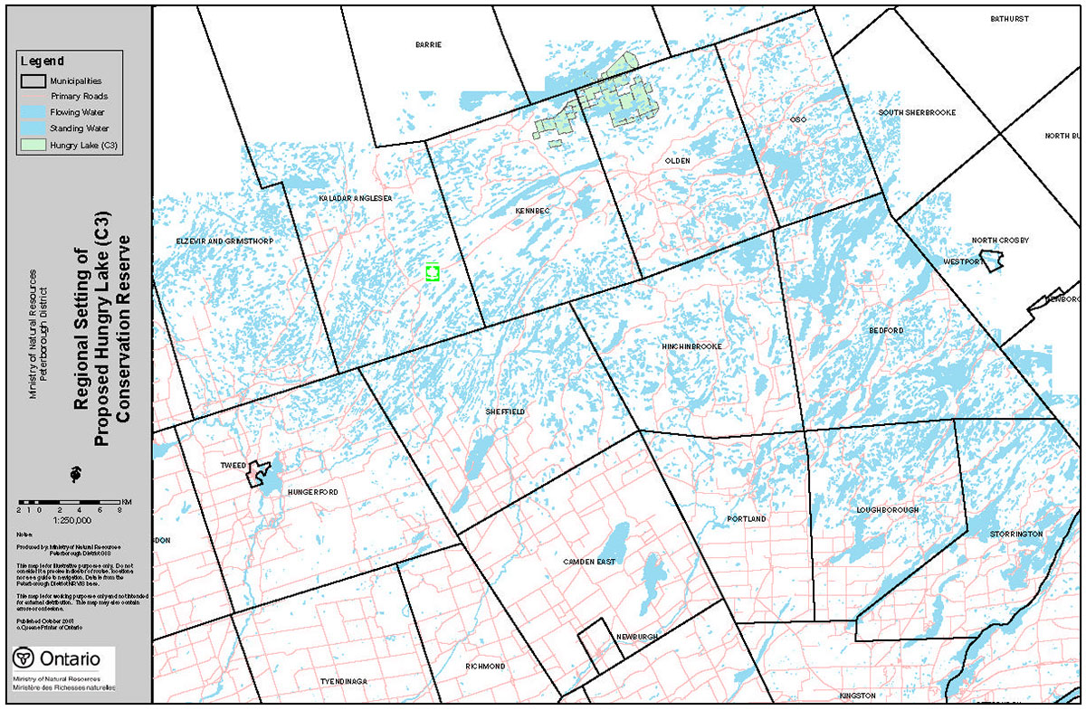
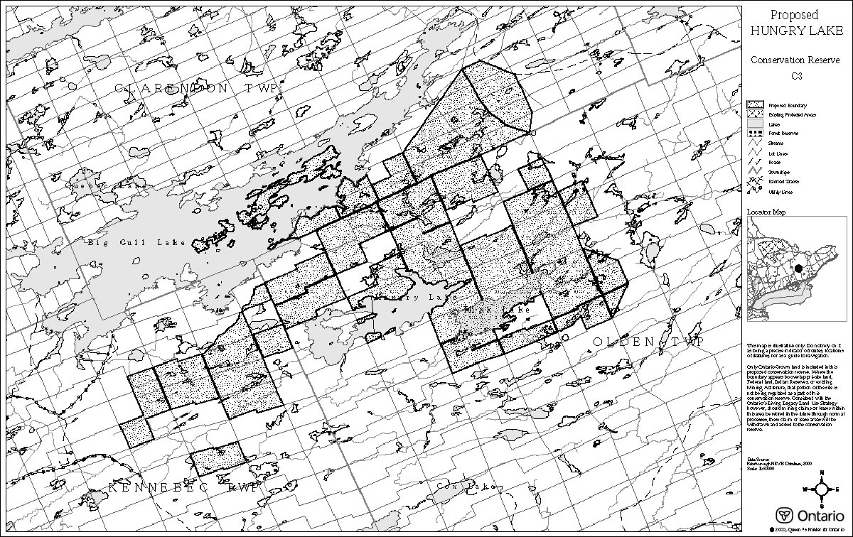
The regional setting for the proposed Hungry Lake Conservation Reserve and the proposed boundary for this Conservation Reserve are shown in Figures 1 and 2 respectively.
As a proposed conservation reserve, the Hungry Lake Conservation Reserve will be regulated under the Public Lands Act, (R.S.O. 1990) with a Statement of Conservation Interest (SCI) prepared in accordance with the Procedural Guideline A – Resource Management Planning, Conservation Reserves Policy and Procedure 3.03.05 (OMNR 1997).
The purpose of this SCI is to identify the various values present in the proposed Hungry Lake Conservation Reserve, including those that have been derived from the geology, ecology and recreation potential of the area. The SCI also outlines the activities that occur within the proposed reserve and provides guidelines for the management of current and future activities in order to protect its natural values.
Figure 1: Setting of the Proposed Hungry Lake Conservation Reserve
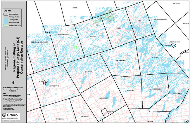
Enlarge: Map for Setting of the Proposed Hungry Lake Conservation Reserve
Figure 2: Boundary of the Proposed Hungry Lake Conservation Reserve
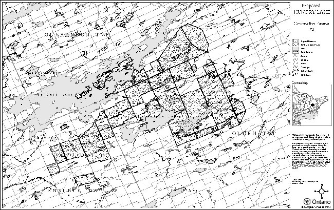
Enlarge: Map for Boundary of the Proposed Hungry Lake Conservation Reserve
1.1 Background information
| Name | Proposed Hungry Lake Conservation Reserve |
|---|---|
| Site Region / Site District | Georgian Bay / 5E-11 |
| OMNR Administrative Region / District / Area | Southcentral Region / Peterborough District / Kingston Area |
| Total Area (ha) | 3518 |
| Regulation Date | Pending |
1.2 Representation targets
Earth science representation:
Located in the Mazinaw Terrane of the Central Meta-sedimentary Belt. The dominant rock type is Northbrook Tonalite, although granitic pegmatite masses and dikes are also abundant.
Life science representation:
Vegetation associations in the site can be grouped into 16 types based on the dominant species, microclimate, soil type and moisture regime:
- Upland vegetation
- Coniferous forest – Hemlock/White Pine/ Red Pine – normal-warmer/loam/mesic-dry mesic
- Mixed forest – Red Oak/White Pine/Red Maple/White Oak – normal-warmer/loam/mesic-dry mesic
- Mesic Deciduous Forest – Sugar Maple/Basswood/White Birch – normal/loam/wet mesic
- Dry Deciduous Forest – White Oak/Red Oak/Red Maple – normal-warmer/loam/dry-dry mesic
- Rock Barrens – variable – normal-warmer/sand-loam/dry-dry mesic
- Cliff – Wavy Hair Grass/Rock Polypody/Rusty Woodsia – colder-warmer/sand/very dry
- Graminoid Meadow – Bracken Fern/Poverty Grass/Common Milkweed – normal/sand/dry mesic
- Wetland
- Shoreline – colder-warmer/sand-rock/mesic-very wet
- Deciduous Swamp – Red Maple – normal/organic/wet mesic-very wet
- Thicket Swamp – Speckled Alder/Meadowsweet/Black Chokeberry – normal/organic/wet mesic
- Open Bog – Black Spruce/Leatherleaf/Beaked Sedge – normal-colder/organic/wet mesic-very wet
- Treed Bog – Black Spruce/Leatherleaf/Labrador Tea – normal/organic/wet
- Treed Fen – Larch/Red Maple – normal/organic/very wet
- Meadow Marsh – Sedges/Wool-grass/Canada Blue-joint – normal/organic/mesic-wet mesic
- Emergent Marsh – Canadian Blue-joint/Cattail/Wool-grass – normal/organic/wet mesic-very wet
- Aquatic Marsh – Water Shield – normal/organic/<1 m water
Cultural resources representation:
No research has been conducted to date, although past logging has occurred in portions of the proposed conservation reserve.
Recreational opportunities:
The proposed conservation reserve supports both consumptive and non-consumptive uses. Current and potential activities include fishing, hunting, camping, ATV use, canoeing and snowmobiling.
1.3 Inventories
| Survey Level | Earth Science | Life Science | Cultural | Recreational |
|---|---|---|---|---|
| Reconnaissance | Duba & Frey, 2000. Site Checksheet | Brunton, 1990. Site District ANSI Report | None | None |
| Detailed | None | White, 1995. Site Survey and Evaluation | None | Barry and Smith, 2000. Recreation Inventory |
| Potential Future Studies | Detailed Inventory | Mammal and Breeding Bird Inventories | Reconnaissance Survey | Impact Study |
2.0 Values to be protected
2.1 Earth science
The proposed Hungry Lake Conservation Reserve is within the Central Meta-sedimentary Belt of the Proterozoic Grenville Province. The Central Meta-sedimentary Belt has been further subdivided into five lithotechtonic terranes and the site is situated in the Mazinaw Terrane, which is characterized by a linear, northeast-trending, accumulation of supracrustral rocks that have been invaded by compositionally diverse plutons of various ages. The dominant rock type of the proposed Hungry Lake Conservation Reserve is Northbrook Tonalite, although younger, cross-cutting, very coarse granitic pegmatite masses and dikes are also abundant.
The earth science features of the proposed Hungry Lake Conservation Reserve indicate that it contributes to the conservation of the Grenville continental accretion theme, as outlined by Davidson (1981). Furthermore, the site is considered to be of regional significance in its representation of an early plutonic component of the Mazinaw Terrane (Duba & Frey 2000).
2.2 Life science
The site is located within the ecological site district 5E-11 and is dominated by two landform types: VIIa-20 [moderately broken bedrock uplands (sandy till, organic)] and VIIa-9 [weakly broken bedrock plain (sandy till, organic)]. The life science values in the proposed Hungry Lake Conservation Reserve, which were assessed using the five standard criteria (representation, condition, diversity, ecological considerations, and special features), were found to be provincially significant. The findings of the Hungry Lake Life Science Checksheet (Barry 2000) are summarized below.
Representation:
The proposed reserve contains the undulating pattern of bedrock ridges and narrow wetlands that are characteristic of the site district, although these features are more extensive and support a larger area of natural scrub vegetation in the Hungry Lake site. Vegetation communities found in the site include extensive rock barrens, dry-site deciduous and mixed forests, and a range of bedrock-controlled peatlands.
Condition:
The area is considered to be relatively free from major disturbances. Limited timber harvesting occurred in the past. Agricultural land use likely occurred on some adjacent private lands. The proposed conservation reserve does, however, experience some of the pressures of recreational use. Snowmobiling may be of particular concern, as the negative effects of this activity have been observed on the rock barrens.
Diversity:
The mosaic of rock barren, wetland and forested habitats contributes to the amount of community diversity that is found in the site. A total of 15 types of vegetative associations were found in the site and within these communities there are 468 species of flora, 136 birds, 35 mammals, and 28 reptiles and amphibians (White 1995).
Ecological considerations:
The proposed Hungry Lake Conservation Reserve lies in close proximity to several existing and proposed protected areas. The presence of the Dead Creek Conservation Area is also important, as it connects the southwest portion of the proposed conservation reserve to the rest of the site. In addition to this high degree of connectivity, the shape of the site is also considered to be beneficial as it is relatively large and has a high proportion of interior habitat. The proposed conservation reserve also has natural buffering capabilities and contains a large amount of headwaters.
Special features:
A large number of species of flora and fauna has been recorded in or adjacent to the site, with some of regional or provincial significance. The provincially significant species are summarized in the table below. In addition to the significant species, there are also four communities that are thought to be of regional, if not provincial, significance. These four communities are large rock barrens, unique peatland associations, undisturbed shorelines and extensive intact forest communities.
| Type of Species | Species Richness | Rare Species |
|---|---|---|
| Flora | 468 species (3 P Rare) | Carey’s Knotweed Virginia St. John’s-wort Discoid Beggarticks |
| Fauna | 136 birds (5 P Rare) | Bald Eagle Red-shouldered Hawk Black Tern Cerulean Warbler Prairie Warbler |
| Fauna | 35 mammals (3 P Rare) | Smoky Shrew Long-eared Bat Southern Lemming |
| Fauna | 28 reptiles and amphibians (1 P Rare) | Five-line Skink |
3.0 Management guidelines
The management guidelines for the proposed Hungry Lake Conservation Reserve have been developed in accordance with the policies and permitted uses described in Conservation Reserves Policy and Procedure 3.03.05 (OMNR 1997) and as a mended by the Ontario’s Living Legacy Land Use Strategy, (OMNR 1999). Appendix A, Indicator Uses For Conservation Reserves – Generic and Specific shows permitted and restricted activities within Conservation Reserves in general as well as within the proposed Hungry Lake Conservation Reserve.
3.1 Land tenure
Background:
The proposed Hungry Lake Conservation Reserve is composed entirely of Crown Land. During the review of the reserve’s proposed boundaries, it was noted that there were some blocks of private land located in the interior of the site. These private lands are not part of the proposed conservation reserve. Unopened road allowances and shoreline road allowances within and adjacent to the proposed conservation reserve boundary are owned by the local municipalities and are also not part of the site.
A number of recreation camps are located on Crown land within the proposed reserve. There is also a fur harvester who works out of the area and has a cabin on Mink Lake. Both the recreational camps and the fur harvester’s cabin are authorized through Land Use Permits.
Guidelines:
Sale of Crown lands within the reserve shall not be considered. Should adjacent lands become available for acquisition, this activity will need to be examined in the context of future planning.
In order to consolidate the proposed conservation reserve boundaries and to facilitate more effective resource management, the Ministry of Natural Resources would be interested in entering into discussions with the townships to close all unopened road allowances and transfer them to the Crown for inclusion within the proposed reserve, if this matter was acceptable to the respective municipalities.
The existing recreation camps will be permitted to continue, undergo periodic maintenance, and may be eligible for enhanced tenure, but not purchase of the land. Requests for the transfer or enhancement of existing tenure will be addressed through a screening process that should include the Test of Compatibility (Appendix B).
The existing use, repair and replacement of the fur harvesting cabin will also be permitted, as long as the scale and function of the cabin is not significantly altered.
3.2 Existing/proposed development
Background:
Existing development in the proposed conservation reserve includes a transmission line into the tourism lodge on Hungry Lake and two private access roads in the west end of the site. While one of these access roads is currently under construction, the other road, which is known as the Elf’s Bay Road, has been in existence for some time. This road is currently passable by a two-wheel drive vehicle and is used by at least fifteen cottagers.
Other development in the site includes nine confirmed campsites located on Big Gull, Hungry and Mink Lakes. There are also two portages and a number of all-terrain vehicle (ATV) and snowmobile trails. All of these features appear to be in good condition and some of the campsites are known to be maintained by local cottagers associations, while the portages are currently maintained by the two tourism lodges located on Hungry Lake.
Guidelines:
No new roads will be permitted within the proposed conservation reserve. The periodic maintenance of all existing roads, including the Elf’s Bay Road, will be permitted.
Existing transmission lines will also be allowed to continue, although all new energy and communication corridors will be discouraged, unless it can be demonstrated that there are no other alternatives.
All other proposals for new development within the reserve must meet the guidelines of Procedural Guideline B – Land Uses – Test of Compatibility Conservation Reserve Policy and Procedure PL 3.03.05 (OMNR 1997) (Appendix B).
3.3 Recreational activities
Background:
Existing recreation activities within the proposed conservation reserve include fishing, hunting, summer camping, ATV use, canoeing and snowmobiling. There are also a number of cottages, resorts and lodges on adjacent patented lands that bring a large amount of recreational users to the area. However, access to the site is somewhat limited, which lowers the recreation potential of the proposed conservation reserve. The only road access to the site is through the two lodges, who both charge a small fee for parking and boat launching.
White’s 1995 evaluation of the Hungry Lake Area of Natural and Scientific Interest (ANSI) notes that motorized vehicles traveling through the southwest portion of the site appear to be having a negative impact on the rock barrens. However, specific impacts have not been documented.
Guidelines:
The current range of recreational uses will be allowed to continue, provided that they do not have a negative impact on the values for which the proposed conservation reserve was selected for protection. However, off-trail ATV and snowmobile use will be restricted to the direct retrieval of game.
In light of concerns over the environmental impact of motorized vehicles to the ecological values of the proposed conservation reserve, snowmobile or ATV trail proposals will be discouraged and will be subject to Procedural Guideline B – Land Use Test of Compatibility (Appendix B). New trails will only be considered if it can be determined that the activity does not pose a significant threat to the rock barren habitat, for which the site was protected.
3.4 Commercial activities
Background:
Current commercial activities on Crown lands within the proposed reserve include baitfishing and fur harvesting. There are two baitfish licenses that encompass the Clarendon Township portion of the site and a licensed trap-line that covers approximately one third of the site.
Guidelines:
Conservation reserves do not permit commercial forestry, hydro development, the extraction of aggregate and peat or other industrial uses (Public Lands Act, Ontario Regulation 805/94).
Existing bait fishing and fur harvesting will be allowed to continue, unless there are significant demonstrated conflicts. New operations can be considered and will be subject to the Test of Compatibility (Appendix B). In the case of fur harvesting, requests for new operations shall also consider the associated trails that would be required. Requests for transfers of the baitfish and fur harvesting licenses will be dealt with on an on-going basis.
Other new commercial activities must meet the requirements of the Procedural Guideline B – Land Use Test of Compatibility (Appendix B).
The Ontario’s Living Legacy Land Use Strategy (OMNR 1999) permits controlled mineral exploration in specific new conservation reserves where provincially significant mineral potential has been identified. The mineral potential for this area is unknown since a mineral resource potential assessment has not yet been undertaken. If significant mineral values are discovered and a mine is developed, the identified area would be deregulated from the conservation reserve and an appropriate replacement area would be added.
3.5 Aboriginal interests
Background:
The proposed Hungry Lake Conservation Reserve is partially situated within an area of eastern Ontario encompassed by the land claim of the Algonquin Nation, which is currently being negotiated by Ontario, Canada and the Algonquin Nation. The site also lies within the Interim Traditional Area (as defined in 1994 by the Ministry of Natural Resources) of the Mohawks of the Bay of Quinte.
Guidelines:
The Ministry of Natural Resources and the Algonquin Nation are developing a protocol to guide discussions on a number of land use matters, including the implementation of Ontario’s Living Legacy Land Use Strategy (OMNR 1999).
In the creation of this proposed conservation reserve, it is not intended that any existing Aboriginal or Treaty rights, as recognized by section 35 of the Constitution Act , 1982, will be abrogated or derogated.
3.6 Natural resource stewardship
3.6.1 General
Background:
To date, natural resource stewardship has been limited to forest management operations in parts of the proposed conservation reserve and fisheries management for Hungry Lake and other waterbodies. In order to sustain the health of the ecosystem and the current level of use, some of the proposed conservation reserve’s representative natural values may require active management.
Guidelines:
Generally, the proposed conservation reserve will be managed by allowing natural ecosystems and processes to function, the emphasis being placed on ensuring that the natural and recreational values of the proposed reserve are protected.
3.6.2 Vegetation
Background:
Some vegetation community associations, including the large regionally significant rock barrens for which the proposed reserve was selected for protection, may require prescribed burns to regenerate them (White 1995). Although it is not known whether or not such activities were ever practiced within the boundaries of the proposed conservation reserve, prescribed burns have been implemented in the Kaladar area in the past.
Insect damage was observed in hemlock stands an island in Big Gull Lake within the boundaries of the proposed conservation reserve (Barry and Smith 2000). This damage may be the result of a documented outbreak of hemlock looper in the Big Gull Lake area in 1996. MNR did not use pesticides on this infestation.
Guidelines:
Although the landscape will be allowed to function naturally, some vegetation communities may need to be examined to determine whether or not fire needs to be introduced into the ecosystem. Such vegetation management will be established within the context of the Ministry’s forest fire protection program and more detailed resource management planning for this area.
Insect control will be determined on a case by case basis and consistent with Procedural Guideline B – Land Use Test of Compatibility (OMNR 1997) (Appendix B).
3.6.3 Wildlife
Background:
The proposed conservation reserve is located in Wildlife Management Unit 62, where deer hunting is permitted, as well as open seasons for moose, black bear, and a variety of small game and waterfowl. A fur harvesting licence also encompasses approximately one third of the site. There is also some active management for wildlife on adjacent lands, as Ducks Unlimited and the Napanee Region Conservation Authority work in conjunction to operate a water-control project in the vicinity of Dead Creek Marsh in order to increase breeding opportunities for waterfowl (White 1995).
All the lakes in the proposed Hungry Lake Conservation Reserve have been classified as warm water, except for Hungry Lake itself, which is a cold water lake. Bass and northern pike are present in all of the lakes, while walleye are found in Big Gull Lake. Lake trout were introduced into Hungry Lake in the 1960's and were stocked until 1992. Current management for fishery resources consists of the annual stocking of splake in Hungry Lake. This stocking provides recreational angling opportunities where natural fish populations are limited or have declined.
Guidelines:
Hunting and fishing in the proposed Hungry Lake Conservation Reserve will be guided by the relevant Ontario hunting and fishing regulations. Fur harvesting will be managed through the maintenance of the current licensing system.
The stocking of splake into Hungry Lake and the potential for other types of fish stocking will also be reviewed periodically to ensure that continued angling opportunities are provided while protecting native fish populations.
3.7 Cultural resource stewardship
Background:
Potential cultural values present in the proposed reserve have not yet been identified, although the area appears to have some historical use such as past logging.
Guidelines:
Interested parties will be encouraged to conduct inventories and studies of the area. Specific recommendations for the stewardship of the proposed reserve’s cultural resources will depend on the results of such investigations.
3.8 Client services
Background:
Site access and services have been very limited to non-existent to date.
Guidelines:
Given the lack of access to the site, client services within the proposed Hungry Lake Conservation Reserve will be limited and focus on self-interpretation. There is currently no intention to develop any public access points, although signage could be placed strategically along the perimeter if future planning warrants such an endeavor.
3.9 Research
Background:
Research in the proposed Hungry Lake Conservation Reserve has focused on inventories of natural heritage features. These inventories have resulted in the area being recommended as a candidate Area of Natural and Scientific Interest (ANSI) (Brunton 1990).
Guidelines:
The ministry will encourage future research and documentation of the area’s values, consistent with Procedural Guideline C – Research Activities in Conservation Reserves (PL 3.03.05) Appendix C. Research emphasis will be placed on gathering additional site information that was lacking in SCI Section 1.3.
3.10 Marketing
Background:
To date, there has been very little promotion of the area. The Mississippi Valley Conservation Authority, along with other independent sources, has published most of the existing information. However, the lack of marketing may be appropriate as increased levels of recreational use in the absence of prior planning may cause damage to the sensitive rock barrens present in the site.
Guidelines:
Given the lack of access to site, extensive marketing of the proposed Hungry Lake Conservation Reserve is not warranted. However, a map and background information on the proposed reserve should be made available to interested parties. All other marketing of the area should focus on the area’s unique contribution to Ontario’s Living Legacy.
4.0 Implementation
Administrative responsibility for this proposed conservation reserve lies with the Kingston Area Office of the Peterborough District and the Mazinaw Area Office of the Bancroft District of the Ministry of Natural Resources. Both Ministry Offices will play a joint role in addressing the management needs of the proposed reserve. Partnerships with local interest groups may also be established, where appropriate.
Implementation priorities include:
- Prepare a basic map and information package (fact sheet) about the proposed Hungry Lake Conservation Reserve
- Encourage further inventory and research activities to enhance information about the proposed reserve
- Explore the possibility of entering into discussions with the municipalities to stop up and close all unopened road allowances within the proposed reserve and transfer these to the Crown
- Encourage additional studies to evaluate the need for public access, other client services, and marketing of the area.
5.0 Review and revision
This SCI will be subject to review and revision on an ongoing basis. Required changes will occur through a standard process of minor and major amendments. Minor amendments will be required for new uses and activities that do not affect or conflict with any of the policies that are already laid out in the SCI. These changes shall be dealt with in a relatively informal manner and will require the approval of the appropriate Area Supervisor. New uses and/or activities that were not anticipated in the preparation of this SCI and which have the potential to have a negative impact upon the values of this proposed conservation reserve will require a major amendment. The major amendment process will include an opportunity for public comment and will require the approval of the District Manager(s) and Regional Director.
References
Barry, Janice. 2000. Natural Heritage Area – Life Science Checksheet: Hungry Lake Conservation Reserve. Ontario Ministry of Natural Resources, Peterborough District.
Barry, Janice and Heather Smith. 2000. Recreation Inventory Report – Hungry Lake Conservation Reserve (C3), Version 1 – October, 2000. Ontario Ministry of Natural Resources, Peterborough District.
Brunton, Daniel F. 1990. Life Science Area of Natural and Science Interest in Site District 5-11: A Review and Assessment of Significant Natural Areas. Ontario Ministry of Natural Resources, Tweed District.
Davidson, R. J. A. 1981. Framework for the Conservation of Ontario’s Earth Science Features. Toronto: Ontario Ministry of Natural Resources, Division of Parks.
Duba, E. and Frey 2000. Earth Science Checksheet – Hungry Lake Barrens Conservation Reserve, Ontario Ministry of Natural Resources, Peterborough.
OMNR, 1999. Ontario’s Living Legacy Land Use Strategy. Ontario Ministry of Natural Resources.
OMNR. 1997. Conservation Reserve Policy and Procedure PL 3.03.05. Ontario Ministry of Natural Resources, Lands and Natural Heritage Branch.
White, David J. 1995. Life Science Survey and Evaluation of the Hungry Lake Barrens Candidate ANSI. Ontario Ministry of Natural Resources, Tweed District.
Appendix A: Indicator uses for Conservation Reserves – generic and specific
(Modifications were made to reflect current OLL policies, as the original chart that is found in the Procedural Guideline B – PL 3.03.05 only applies to pre-OLL conservation reserves )
Industrial activities
| Activity | Generic OLL Policy Permitted? New | Generic OLL Policy Permitted? Existing | Specific Application In Proposed Hungry Lake Conservation Reserve Existing | Specific Application In Proposed Hungry Lake Conservation Reserve New |
|---|---|---|---|---|
| Commercial timber harvest | No | No | No | No |
| Cutting of trees by leaseholders and property owners for fuelwood and small-scale uses | Maybe | Maybe | Maybe | Maybe |
| Timber salvage/sunken log retrieval | Maybe | Maybe | Maybe | Maybe |
| Mineral exploration | Maybe | Maybe | Maybe | Maybe |
| Mining | No |
No |
No |
No |
| Extraction of peat, soil, aggregate, other materials | No | No | No | No |
| Forest renewal | Maybe |
Maybe |
Maybe |
Maybe |
| Hydro power generation | No | No | No | No |
| Communications corridors | Yes | No |
Yes | No |
| Energy transmission corridors | Yes | No |
Yes | No |
| Transportation corridors | Yes | No |
Yes | No |
| Resource access roads | Maybe |
Maybe |
Maybe |
Maybe |
| Private access roads | Yes | No |
Yes | No |
Recreation activities
| Activity | Generic OLL Policy Permitted? New | Generic OLL Policy Permitted? Existing | Specific Application In Proposed Hungry Lake Conservation Reserve Existing | Specific Application In Proposed Hungry Lake Conservation Reserve New |
|---|---|---|---|---|
| Sport fishing | Yes | Yes | Yes | Yes |
| Sport hunting | Yes | Yes | Yes | Yes |
| Facility development | Maybe | Maybe | Maybe | Maybe |
| Non-trail snowmobiling | Maybe |
Maybe |
Maybe |
Maybe |
| Non-trail ATV use | Maybe |
Maybe |
Maybe |
Maybe |
| Motorized boating | Yes | Yes | Yes | Yes |
| Camping | Maybe | Maybe | Yes | Yes |
| Private recreation camps | Y |
No | Yes |
No |
Commercial activities
| Activity | Generic OLL Policy Permitted? New | Generic OLL Policy Permitted? Existing | Specific Application In Proposed Hungry Lake Conservation Reserve Existing | Specific Application In Proposed Hungry Lake Conservation Reserve New |
|---|---|---|---|---|
| Fishing | Yes |
Maybe | Yes |
Maybe |
| Bait-fish harvesting | Yes |
Maybe | Yes |
Maybe |
| Commercial fur trapping | Yes |
Maybe | Yes |
Maybe |
| Trapping cabin | Yes | No | Yes | No |
| Out-post camps/tourism facilities | Maybe |
Maybe |
Maybe |
Maybe |
| Commercial bear hunting (tourist operators) | Yes | No | Yes | No |
| Wild rice harvesting | Yes |
Maybe | Yes |
Maybe |
| Food harvesting | Maybe | Maybe | Maybe | Maybe |
Resource management activities
| Activity | Generic OLL Policy Permitted? New | Generic OLL Policy Permitted? Existing | Specific Application In Proposed Hungry Lake Conservation Reserve Existing | Specific Application In Proposed Hungry Lake Conservation Reserve New |
|---|---|---|---|---|
| Resource inventorying | Yes | Yes | Yes | Yes |
| Resource monitoring | Yes | Yes | Yes | Yes |
| Fire protection | Yes | Yes | Yes | Yes |
| Insect and disease | Maybe | Maybe | Maybe | Maybe |
| Featured Species Management | Maybe | Maybe | Maybe | Maybe |
Other activities
| Activity | Generic OLL Policy Permitted? New | Generic OLL Policy Permitted? Existing | Specific Application In Proposed Hungry Lake Conservation Reserve Existing | Specific Application In Proposed Hungry Lake Conservation Reserve New |
|---|---|---|---|---|
| Research | Yes | Yes | Yes | Yes |
| Collecting | Maybe |
Maybe |
Maybe |
Maybe |
| Food Gathering | Yes | Yes | Yes | Yes |
| Land disposition | Maybe | Maybe | Maybe | Maybe |
| Habitat Management for Wildlife | N/A | N/A | N/A | N/A |
| Research | Yes | Yes | Yes | Yes |
| Collecting | Maybe |
Maybe |
Maybe |
Maybe |
| Food gathering | Yes | Yes | Yes | Yes |
| Land disposition | Yes |
Maybe |
Yes |
Maybe |
| Habitat Management for Wildlife | Maybe |
Maybe |
Maybe | Maybe |
Appendix B: Procedural guideline B – Land Uses – Test of Compatibility (OMNR 1997)
The Conservation Reserve policy provides broad direction with regard to the permitted uses. The policy provides only an indication of the variety of uses that will be considered acceptable in conservation reserves. The only caution is that "any new uses, and commercial activities associated with them, will be considered on a case by case basis, and, they must pass a test of compatibility to be acceptable." What does a 'test of compatibility' mean?
An examination of this must start from the premise of why an area is set aside- specifically, its representative natural heritage values. Criteria are then identified to guide compatibility considerations. These criteria apply to the long-term acceptability of both existing uses and new uses.
-
Conformity to SCI/RMP: SCI describe values for which an area has been set aside and the range of appropriate uses that will be permitted in the area. SCI may also speak to the acceptability of other 'new' uses currently not occurring in the area.
The first 'test' is: "do proposed new land uses and/or commercial activities conform to the direction of the SCI/RMP for the conservation reserve? Would the new use(s) depart from the spirit of appropriate indicator land uses in the SCI/RMP?"
- Impact Assessment: If the proposed use(s) pass test one it is important to determine their impact on the area before they are approved. This should include the following:
- impact on natural heritage values: "will the new use(s) impact any natural values in the area? If so how and to what degree? Is it tolerable?"
- impact on cultural values: "will the new use(s) impact any historical or archaeological values in the area?"
- impact on research activities: "will the new use(s) affect any research activities in the area?"
- impact on current uses: "will the new use(s) have any negative impact on the array of current uses?"
- impact on area administration: "will the new use(s) increase administrative costs and/or complexity?" (For example, the cost of area monitoring, security and enforcement).
- impact of accommodating the use outside the conservation reserve: "Could the use(s) be accommodated as well or better outside the conservation reserve?"
- impact on socio-economics of the area: "will the new use(s) affect the community(ies) surrounding the area in a positive or negative way?" (For example, will the new use make the area less remote thereby affecting a local tourism industry that is dependent on the area’s remoteness for its appeal)?
- impact on area accessibility: "does the new use(s) give someone exclusive rights to the area or a portion of the area to the exclusion of other existing uses?"
Appendix A (Indicator Uses for Conservation Reserves-Generic and Specific) provides a guide of indicator uses for the consideration of uses that may be permitted within conservation reserves. For any specific conservation reserve the test of compatibility should be applied to determine which specific uses are acceptable.
Appendix C: Procedural Guideline C – Research Activities in Conservation Reserves (OMNR 1997)
To encourage contributions to the goal of conservation reserves by:
- providing direction for research activities associated with conservation reserves
- establishing a process for the review and approval of proposals by researchers, which could have an impact on the values protected by the conservation reserve
Definition
Research means any investigation or study of the natural, cultural, social, economic, management or other features or characteristics of conservation reserves.
Guidelines
Research will be encouraged to provide a better understanding of the natural values protected by a conservation reserve and to advance their protection, planning and management. The Statement of Conservation Interest will define, for each conservation reserve, the key research issues, set out the parameters within which research may occur and identify research needs.
Applications and approvals
Researchers must apply in writing to the Area Supervisor for permission to conduct research. The request letter must contain a statement explaining why the proposed research should be undertaken in the particular conservation reserve in preference to another location.
Proposals will be reviewed and approved by the Area Supervisor, guided by the Statement of Conservation Interest prepared for each reserve (see Guideline A – Resource Management Planning) and using Guideline B – Land Uses – Test of Compatibility. Permission must be granted in writing, including any conditions to be met in conducting the research, prior to the undertaking of any research project.
Terms and conditions
Permission to conduct research under this policy will be valid for a period of 12 consecutive months from date of issue. Permission to continue a research project for additional periods of 12 months or less may be granted upon submission of a written request and progress report. The Ministry may require the posting of collateral to assure that the terms and conditions of granting permission are met.
The Area Supervisor may suspend or revoke permission at any time for failure on the part of the researcher to meet:
- The intent or conditions of this policy
- The requirements under the Public Lands Act, including all amendments, where applicable
- The requirements under any other Act or Regulations of Ontario or Canada, including those governing the taking, handling, storing, confining, trapping, excavating and marketing any specimen, artefact, information or action (for example, scientific collector’s permit)
- The conditions and agreements specified in granting permission
Final report
The researcher will submit copies of reports, publications and theses following from the results of the project to the Area Supervisor.
Footnotes
- footnote[1] Back to paragraph If, as a result of a controlled mineral exploration, a site within a conservation reserve in the OLL planning area is to be developed for a mine, it will be deregulated and appropriate replacement area added to the reserve.
- footnote[2] Back to paragraph If a new conservation reserve has been recently cut, companies have an obligation to proceed with renewal. It can be conducted where it will be of net benefit to the protected area and to, the greatest extent possible, it should be designed to replicate natural conditions.
- footnote[3] Back to paragraph The intent is to actively discourage these uses, but it is recognized that in some circumstances these will be no alternative; this will be determined through planning.
- footnote[4] Back to paragraph New private access roads, including additions to existing roads, will not be permitted except where there are previous commitments that were made prior to March 29, 1999. Such commitments will be subject to the completion of a public planning process.
- footnote[5] Back to paragraph Use may be permitted for the direct retrieval of game only.
- footnote[6] Back to paragraph Existing private recreation camps are eligible for enhanced tenure but not for the purchase of lands. A decision to grant enhanced tenure, or to transfer recreational camps will be addressed though a screening process.
- footnote[7] Back to paragraph Existing use permitted to continue, unless there are significant demonstrated conflicts. New operations can be considered, subject to the 'test of compatibility.'
- footnote[8] Back to paragraph Existing authorized tourism facilities can continue unless there are demonstrated conflicts. The operators of tourism facilities can apply to upgrade tenure from LUP to lease. New tourism facilities can be considered during planning for a conservation reserve.
- footnote[9] Back to paragraph Must be part of an authorized research project.
- footnote[10] Back to paragraph Sale of lands is not permitted with the exception of some minor types of dispositions where it does not detrimentally affect the values an area is intended to protect. Renewals of existing leases of land use permits will be allowed for approved activities.