Inverhuron Provincial Park Management Plan
This document provides direction on the management of Inverhuron Provincial Park.
Park Management Plan
© 2001, Queen’s Printer for Ontario
Additional copies of this publication are obtainable from:
MacGregor Point Provincial Park
R.R. #1
Port Elgin, Ontario N0H 2C5
Telephone: 1-519-389-9056
3358-2
(0.15k REPRINT, 01 11 30)
ISBN 0-7778-8525-5
July 13, 2000
Dear Sir/Madam:
I am pleased to approve the Inverhuron Provincial Park Management Plan as the official policy for the management and development of this park. The plan reflects the Ministry of Natural Resources' and Ontario Parks' intent to protect the natural and cultural features of Inverhuron Provincial Park and maintain and develop high quality opportunities for outdoor recreation and heritage appreciation for the residents of Ontario and visitors to the Province.
The plan outlines a prioritized implementation strategy for the plan’s elements and summarizes the public consultation that occurred as part of the planning process.
The public is given a final opportunity to review the approved Management Plan for a period of forty-five (45) days after its formal release. This allows interested participants in the planning program a final opportunity to determine if their concerns have been considered, and if necessary, to initiate an appeal concerning the plan’s contents.
The plan for Inverhuron Provincial Park will be used to guide the management of the park. It may be reviewed to address changing issues or conditions. A mandatory review is to be held after 10 years.
I wish to extend my sincere thanks to all those who participated in the public consultation process.
Yours truly,
Signed by
Adair Ireland-Smith
Managing Director
Ontario Parks
Statement of Environmental Values and the Environmental Bill of Rights
In accordance with the provisions of the Environmental Bill of Rights (EBR), the Ministry of Natural Resources prepared a Statement of Environmental Values (SEV). It describes how the purposes of the EBR are to be considered whenever decisions are made which might significantly affect the environment. This includes decisions made as the result of a park management planning process.
The primary purpose of the EBR is "to protect, conserve and, where reasonable, restore the integrity of the environment". From the Ministry’s perspective, that broad statement of purpose translates into four objectives in its SEV:
- to ensure the long-term health of ecosystems by protecting and conserving our valuable soil, aquatic resources, forest and wildlife resources as well as their biological foundations
- to ensure the continuing availability of natural resources for the long-term benefit of the people of Ontario
- to protect natural heritage and biological features of provincial significance; and
- to protect human life, the resource base and physical property from the threats of forest fires, floods and erosion
The Ministry’s SEV was considered throughout the process of preparing a new management plan for Inverhuron Provincial Park. The plan will further the objectives of managing Ontario’s resources on an ecologically sustainable basis.
1.0 Introduction
Inverhuron Provincial Park is situated on Lake Huron off Highway 21, 14.5 kilometres northeast of the community of Kincardine (Figure 1). The community of Inverhuron borders the park. The park lies within the amalgamated Municipality of Kincardine, County of Bruce.
Development of the 288-hectare park began in 1956 and the first summer of operation was in 1959. The park was first regulated under the Provincial Parks Act in 1967 (Ontario Regulation 245/67) and later amended in 1987 (Ontario Regulation 675/87) for a boundary correction.
With construction of the Bruce Nuclear Power Development adjacent to the park, and specifically the heavy water plant, safety and security concerns made it necessary for the Hydro Electric Power Commission of Ontario to purchase the park in 1973. In that same year, a 999-year lease was signed granting the Ministry of Natural Resources permission to continue operating the park as a day use area. The former campground was phased out by 1976.
As a result of the shutdown of the last of the Bruce Nuclear heavy water plants, the lease between the Ministry of Natural Resources and Ontario Hydro (now Ontario Power Generation) was amended in 1998, such that current conditions for operation of the park may allow:
- expanded public access
- extended hours of operation
- extended operating season; and
- reintroduction of overnight camping
As a condition of the operating licence for Bruce Nuclear, Ontario Power Generation has retained a 914-metre radius exclusion zone at the northwest corner of the park. The licence condition states that ownership and control of any land within the exclusion zone shall be maintained by Ontario Power Generation and no use shall be made without prior written approval of the Atomic Energy Control Board. For the purpose of public safety, a fence and gates were erected in 1998 as a means of effectively preventing public access. Restricted access for Ontario Parks' staff will be allowed into this area for access control and other management purposes.
The park is located on a former lake plain associated with Lake Nipissing, which was created following the last glaciation period. The result is a generally flat topography with some rolling sections. Interesting topographic features include the former glacial lake shoreline and a sand dune system. The park is underlain by Palaeozoic sedimentary rocks of the Middle Devonian Detroit River Group, which are approximately 370 million years old. Other than Lake Huron, the most significant hydrological feature is the Little Sauble River, which crosses the park before emptying into the lake at the park’s southern boundary.
Figure 1: Regional context map of Inverhuron Provincial Park
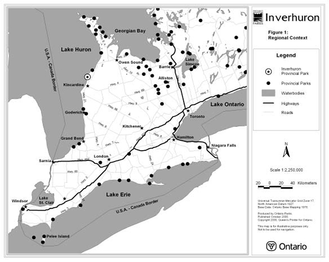
Enlarge figure 1 regional context map of Inverhuron Provincial Park
Most of the vegetation is in some form of early successional stage, primarily due to logging, clearing and other activities prior to park establishment. The park contains many sites of prehistoric and historical interest, which span at least 3,000 years from the Archaic Indians to European settlement. Laid out in 1851, the townsite of Inverhuron was named from the Gaelic word inver meaning "confluence" because the settlement was on Lake Huron at the mouth of the Little Sauble River. Prior to 1882, the community’s fine harbour was a port of call for lake steamers and a trans-shipment point for grain, bark, cordwood and lumber.
Inverhuron Park’s day use resources and facilities include a one-half kilometre long beach with parking for approximately 300 vehicles. Other facilities include a picnic shelter, change house, comfort station, washrooms, a boat launching ramp and a walking trail. In 1999, an estimated 33,000 day trippers visited the park.
In recognition of the significant Aboriginal archaeological features located within Inverhuron Provincial Park, Ontario Parks will have special regard for local First Nations' particular interests. Respect and protection of archaeological and cultural features are a key component of this park management plan. The Chippewas of Saugeen and Nawash First Nations will be consulted on related issues of concern during the implementation of this plan.
Nothing in this document shall be construed so as to derogate from, or abrogate any Aboriginal, treaty, constitutional or any other First Nation rights or the rights, powers or privileges of the Province of Ontario. Nothing in this document shall be construed as an acknowledgement of any rights asserted or the validity of any claim asserted by First Nations.
This current document replaces the 1985 park management plan and a 1987 plan amendment.
2.0 Classification
Inverhuron Provincial Park was originally classed as a natural environment park. The 1985 Inverhuron Provincial Park Management Plan approved a change to recreation class. This occurred because the park provided day use recreational activities (within only a small area of the overall land base) which were compatible with the safety precautions required at the time by the Atomic Energy Control Board of Canada and Ontario Hydro.
The park contains a series of prehistoric Aboriginal archaeological sites and several reminders of early Canadian settlement. Of note is the presence of sites from the Archaic period and subsequent cultural traditions, indicating that the area was occupied for many centuries. The materials are in a stratified situation that makes them all the more important. The prehistoric sites at Inverhuron are associated with provincially important themes, while those associated with European settlement are most likely of local or regional significance.
Given the foregoing, Inverhuron is now classed as a historical provincial park. Historical parks are areas selected to represent distinctive historical resources of the province in open space settings, and are protected for interpretive, educational and research purposes.
The historical classification will allow for the reintroduction of overnight camping facilities.
3.0 Goal
The goal for Inverhuron Provincial Park is to provide a variety of outdoor recreational opportunities which utilize the natural and cultural landscapes of the park, while protecting significant archaeological, historical, biological and geological resources.
Inverhuron Provincial Park is governed by the Ontario Provincial Parks Act, the Ontario Provincial Parks Policy and Ontario Provincial Parks: Planning and Management Policies (1992).
4.0 Objectives
There are four established objectives for the Ontario provincial parks system: protection, recreation, heritage appreciation and tourism. As a historical class park, Inverhuron would contribute to each of these four objectives.
4.1 Protection
The park’s protection objective is to protect provincially significant special and representative prehistoric and historical resources.
The protection objective will be accomplished through appropriate zoning, land use controls, research, monitoring and a greater park ecosystem approach to park planning and management. The greater park ecosystem can be defined as the area of influence surrounding Inverhuron Provincial Park from an ecological, social and economic point of view. It is also the area where most of the impacts affecting the park occur. Inverhuron has its own, unique greater park ecosystem, based on the specific objectives that the park has been established to protect. A number of variables including vegetation, watershed, geology, habitat, recreation, tourism and development can be used to define the greater park ecosystems. The ecosystem management approach is a co-operative and participatory one. It does not imply provincial control in local affairs or placing any restrictions on private property rights.
The park protects a wide range of landscape-related historical resources associated with sufficient open space to permit the development of a park in an outdoor recreational context.
Ontario Parks shall work in partnership with the Chippewas of Saugeen and Nawash First Nations in the protection of the Aboriginal cultural features found within the provincial park.
Cultural resources
The history of human occupation at Inverhuron covers a span of 3,000 years. The first recorded inhabitants were Archaic Indians, and they were followed by a succession of different Aboriginal cultures. European settlement occurred during the latter half of the 19th century. Artifacts from these varied groups can be found throughout the park and thus human history at Inverhuron is tangible and easily discovered.
The Archaic Indian period in Ontario lasted from 5,000 B.C. to 1,000 B.C., and Inverhuron represents one of the largest known Archaic sites in the province. It is a cultural stage that precedes the introduction of ceramics, agriculture and settled life. The Archaic period is subdivided into two cultures, the Shield Archaic and Laurentian Archaic. The Inverhuron material shows some similarities to each but has some unique features. The Inverhuron Archaic has been referred to as "unique" in Eastern Canada.
The appearance of pottery initiates the Woodland period dating from about 1,000 B.C. to the Historic period. The Saugeen was the initial Woodland culture to occupy the park area (700 B.C. to 1,000 A.D.). Evidence from the site suggests that these peoples gathered here at a favoured fishing location during the spring and summer. The community dispersed during the late summer and fall as family units returned to their hunting grounds. The Indians that occupied Inverhuron during the Terminal Woodland period (1,000 A.D. to Historic) were of the Ontario Iroquois group. The Iroquois site in the park probably represents a spring and early summer fishing station.
The second half of the 19th century saw the rise of a town on Inverhuron Bay. In 1856, the townsite of Inverhuron was surveyed. Early development consisted of a grist mill and saw mills on the Little Sauble River. Cleared land was sown with wheat and there was also some commercial fishing. The primary economic base of the town was shipping with the principal exports being grain and hemlock bark. A harbour of refuge never developed fully at Inverhuron due to the absence of a breakwater.
Based on the available data, Inverhuron Park would appear to be the most outstanding "time capsule" available regarding human activities along the Lake Huron shoreline in the Canadian biotic province over the last 3,000 years. This fact is due in large measure to the former and present geomorphology of the park area.
Life science
The existing park ecosystem is primarily a result of human activities. The park is in an early successional state due to logging, clearing, farming and fires. A diverse list of 265 plant species has been identified in the park. Several species are provincially or regionally rare.
The most extensive cover is a second-growth forest composed of White Cedar, Balsam Fir and Aspens with other scattered hardwoods. This community covers the northern section of the park. This forested area occurs over gravel ridges and is characterized by very shallow soil, numerous wet areas and blown-down trees.
The overgrown fields in the vicinity of the park entrance represent the attempts by settlers to cultivate the lands. Forest cover is slowly reclaiming this area. The successional process here is at a very early stage, and some fields contain the remnants of old orchards.
The woods along the Little Sauble River represent the maturest forest within the park. This area was the timber preserve for the sawmill located near the mouth of the river and thus was not totally cleared. The composition of the forest varies with the dominant trees being White Cedar, Maple, Ash and Hemlock.
Inland from the present beach is a sand dune succession system consisting of young dunes, open grassland and a second dune with a cover of White Cedar and Poplars. The continuation of the system past the second dunes has been disrupted by human activities. These dunes consist of sparsely grassed areas, bracken grasslands, remnant White Cedar groves, blowouts and reforested areas.
The park’s ecological communities support a number of mammal species including rabbits, foxes, squirrels, weasels, beaver and deer. Just over 200 species of birds have been observed in the park. The number of breeding species recorded for the park and adjacent area for the Ontario Breeding Bird Atlas was 103. Bald Eagles winter in the area due to the fish attracted to the warm waters off the Bruce Nuclear. Large concentrations of waterbirds (loons, grebes and ducks) can be observed offshore during the spring and fall migrations. A substantial hawk migration also occurs through the area.
The Little Sauble River represents a warm water habitat containing such fish species as White Sucker, Common Shiner and Johnny Darter. Rainbow Trout ascend the stream during the spring and fall. The common game fish caught in Lake Huron are Rainbow Trout and Chinook Salmon.
Earth science
Palaeozoic sedimentary rocks of the Middle Devonian Detroit River Formation underlie Inverhuron Provincial Park. This carbonate rock originated as layers of thick marine deposits and was transformed into dolomite during the intervening eras. The bedrock has determined the shoreline configuration of both Gunn Point and Douglas Point, and the partly enclosed inlets of Inverhuron Bay and Holmes Bay. The bedrock also forms a prominent offshore shelf.
Inverhuron Provincial Park exhibits a typical coastal dune system in Inverhuron Bay, which lies on the shallow bedrock shelf of a postglacial lake plain. A steep Lake Algonquin bluff lies about 1.6 kilometres inland. Several rivers have cut the bluff, supplying sediments for the construction of more recent landforms. During the Lake Nipissing flood (4,000 B.P.), a cuspate foreland (an accretion of sand and pebbles) developed, probably because bedrock is close to the surface in the Douglas Point vicinity. At its southern end it was composed of a baymouth bar and the Little Sauble River cut the bar at a slightly different location than the present breach. The Nipissing bar crosses the northeast corner of the park property. It has been reworked by wind action during post-Nipissing times.
As the Nipissing waters receded about 3,600 years ago, abundant sandy material permitted the construction of a series of beach ridges between the bedrock promontory at Gunn Point and the present townsite. As well, wind action created a typical coastal dune sequence composed of a narrow and badly disturbed foredune and a large area of transverse and parabolic dunes through which the Little Sauble River has meandered, constantly changing its course. The mouth of the river has been pushed southwards by littoral drift, and silted ox-bows have left small marshy areas within the dune field.
The Inverhuron Bay coastal dune sequence was a significant geomorphological feature before human habitation and park development. The exposure of the Detroit River Formation is one of the few natural occurrences of this bedrock feature in Ontario. Inverhuron Beach undoubtedly provides an important recreation facility along this stretch of Lake Huron.
4.2 Recreation
The park’s first recreation objective is to provide day use opportunities in an area of outstanding recreational potential associated with the park’s natural and historical environments.
The park’s second recreation objective is to provide facility-based camping opportunities in the park’s natural and historical environment and in an associated area of outstanding recreational potential.
The park will emphasize natural and historical-based experiences that provide individuals, families, and small groups with a low-intensity of contact with fellow recreationists.
Inverhuron Park has an excellent sandy beach and associated picnic area for day use recreation opportunities. Park roads and trails provide walking and cycling opportunities. A boat launch provides access to sport fishing and recreational boating on Lake Huron. Informal winter recreational activities may include snowshoeing and cross-country skiing. Snowmobiling may be permitted on designated park roads or trails.
Should overnight camping be reintroduced into the park, this would include car camping and group camping experiences.
Figure 2: Existing development of Inverhuron Provincial Park
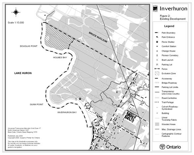
Enlarge Figure 2: Existing development of Inverhuron Provincial Park
4.3 Heritage appreciation
The park’s first heritage appreciation objective is to provide opportunities for unstructured individual exploration and appreciation of the outdoor cultural heritage of the park.
Individual exploration and appreciation (by means of trails and interpretive panels) will be encouraged when compatible with and complementary to protection of pre-historic and historical features.
The park’s second heritage appreciation objective is to provide opportunities for exploration and appreciation of cultural environments through interpretation and education based upon the character and significance of the park.
The park may provide interpretive and educational opportunities for a wide range of individuals and groups to participate in activities and lifeways rooted in the landscape and physical environment, and basic to past human development in the Province. Restoration of historical features will be limited in scale and directed primarily to protection and maintenance. A heritage centre, amphitheatre, interpretive trails, viewing platforms, facilities and strategically sited interpretive panels may be developed in conjunction with a natural heritage education program to facilitate heritage appreciation in the park.
4.4 Tourism
The park’s tourism objective is to provide Ontario residents and out-of-province visitors with opportunities to discover and experience this distinctive region of Ontario.
Day use and camping opportunities may be provided for passing travellers as well as destination camping opportunities for those attracted from considerable distances. Inverhuron has the potential to make positive and direct contributions towards both the local and regional economies.
5.0 Boundary
The park land base is owned by Ontario Hydro and leased back to the Ministry of Natural Resources for the continued management and operation of the provincial park.
The park boundary is described by Ontario Regulation 675/87 made under the Provincial Parks Act. The total park area is 288 hectares. The present regulated park water boundary on Lake Huron is 91.44 metres from the water’s edge (an estimated 39 hectares). It is recommended that this boundary be extended to 400 metres in order to protect potential marine archaeological features.
An overhead hydro transmission corridor traverses the northeast corner of the park.
Nothing in this section shall be construed so as to derogate from, or abrogate any Aboriginal, treaty, constitutional or any other First Nation rights or the rights, powers or privileges of the Province of Ontario. Nothing in this section shall be construed as an acknowledgement of any rights asserted or the validity of any claim asserted by First Nations.
6.0 Zoning
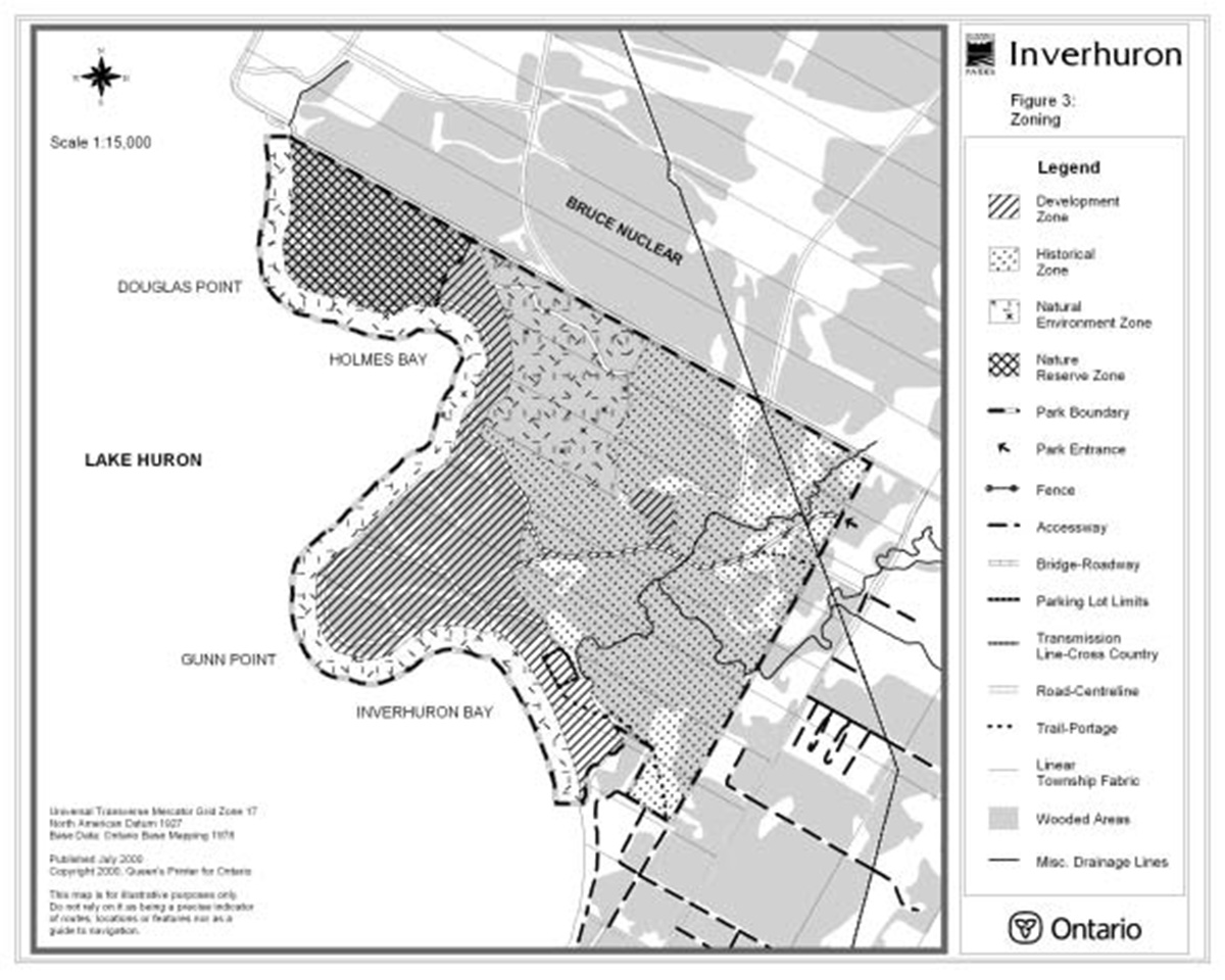
Lands contained within Inverhuron Provincial Park are zoned in accordance with their environmental and historical qualities, and require protection. The four zoning categories designated for the Inverhuron Provincial Park (historical, nature reserve, development and natural environment) are based on the Ontario Provincial Parks: Planning and Management Policies. The zones differentiate the permissible degree of development, recreational uses and management practices within the provincial park (see Figure 3).
6.1 Historical zone
Historical zones include the significant historical resources and landscapes of the park in which there is minimum development required to support visitor exploration, appreciation and scientific research.
Within the historical zone (122 hectares), development will be limited to trails, necessary signs, interpretive, educational, research, and management facilities, and historical restorations or reconstructions where appropriate. Restorations and reconstructions are complex undertakings that will conform to high standards of historical authenticity and will be complementary to and will not interfere with the integrity of the historical resource.
6.2 Nature reserve zone
Nature reserve zones include any significant earth or life science features that require management distinct from that in adjacent zones.
Within the nature reserve zone (28 hectares), development will be limited to access trails, necessary signs, minimal interpretive facilities, and temporary facilities for research and management. The nature reserve zone is overlapped by an exclusion zone (see Figure 2) as described under Section 1.
6.3 Development zone
Development zones provide access where appropriate for large numbers of visitors to the park, and facilities and services for day use and camping activities. They constitute a relatively small portion of individual parks.
Within the development zone (67 hectares), development may include roads, visitor control structures, day use facilities, boat launch and docks, vehicle campgrounds, viewing or fishing platforms, basic commercial service facilities for visitors, and orientation, interpretive, educational, research and management facilities. Day use and camping facilities may be developed to standards that will encourage natural environment based activities and provide for non-crowded conditions and relative freedom from the intrusions of fellow recreationists. The existing site of the boat launch may be relocated in light of wind and wave exposure and dredging requirements.
Notwithstanding the development zoning, impacts on both archaeological features and significant natural resources will be avoided or mitigated.
Between the beach and day use parking, stairs and boardwalks or other suitable structures may be used to channel public access through the shoreline sand dunes. Aside from an existing trail and bridge, no development will be permitted in the area between the mouth of the Little Sauble River and the day use comfort station. Recreational use of this area may be discouraged in order to protect significant features.
6.4 Natural environment zone
Natural environment zones include aesthetic landscapes, primarily where these provide an appropriate adjacent setting for historical zones, in which there is minimal development required to support low-intensity recreational activities.
Within the natural environment zone (71 hectares), development will be limited to a range of trails, viewing platforms, signs for route identification, minimal interpretive facilities, and similar simple facilities that support low-intensity recreational activities. A recommended expansion of the park water boundary to protect potential marine archaeological features would add approximately 86 hectares to this zone.
Figure 3: Zoning map of Inverhuron Provincial Park

Enlarge Figure 3: Zoning map of Inverhuron Provincial Park
7.0 Resource stewardship policies
7.1 Landforms
The following landform stewardship policies may be addressed in greater detail in a subsidiary resource stewardship strategy, as required.
Waters in historical, natural environment and nature reserve zones will not be controlled except to perpetuate natural features and conditions where desirable.
No new utility lines or rights of way will be developed except for those required for servicing the park. Solid waste and sewage may be disposed of outside the park through appropriate local facilities.
Impacts of park development and recreational use on significant landform features will be avoided or mitigated.
7.2 Vegetation
The following vegetation stewardship policies may be addressed in greater detail in a subsidiary resource stewardship strategy, as required.
Non-native plant species will not be deliberately introduced. Where non-native plant species (e.g., Scot’s Pine, Purple Loosestrife) are already established and threaten the values, a management program for their eradication may be developed. Missing native species may be re-established if biologically feasible and acceptable and if compatible with the historical values for which the park has been established.
Stabilization of both the shoreline and backshore sand dunes will be a priority. This may involve planting of native dune grasses, shrubs and trees.
Agricultural practices and commercial forest operations will not be permitted.
7.3 Wildlife
The following wildlife stewardship policies may be addressed in greater detail in a subsidiary resource stewardship strategy, as required.
An eradication program of non-native animal species may be developed if they conflict with the values for which the park has been established. Missing native species may be reintroduced and existing populations replenished, if biologically feasible and acceptable and if compatible with the historical values for which the park has been established.
Animal populations may be controlled when essential to human health and safety, the health of the species outside the park, or the values for which the park has been established. Where control is necessary, techniques will be used having minimal effects on other components of the park’s environment. Appropriate methods of population control may be undertaken directly by Ontario Parks, or through partnerships under the strict supervision of Ontario Parks. Should control of the park’s White-tailed Deer population ever become necessary, Ontario Parks shall consult with local First Nations prior to taking any action.
Low intensity sport fishing may be encouraged on the Little Sauble River provided it does not conflict with natural or cultural values. Sport fishing may be encouraged on Lake Huron. The park’s boat launch is important in terms of providing recreational boating and angling access to the lake.
Sport hunting and commercial trapping will not be permitted.
Nothing in this section shall be construed so as to derogate from, or abrogate any Aboriginal, treaty, constitutional or any other First Nation rights or the rights, powers or privileges of the Province of Ontario. Nothing in this section shall be construed as an acknowledgement of any rights asserted or the validity of any claim asserted by First Nations.
7.4 Cultural resources
Inverhuron Provincial Park contains significant examples of both pre-historic and historical features. Some resources possess considerable potential for interpretation.
A comprehensive cultural resource stewardship plan may be prepared to address methods and policies for inventory, assessment, management, protection and monitoring of the park’s cultural values, to rate the significance of known sites, and to determine interpretive potential.
Priorities for cultural research are identified in Section 9.2 pertaining to research.
Ontario Parks will consult with the Chippewas of Saugeen and Nawash First Nations on matters pertaining to Aboriginal history, sites in the park associated with Aboriginal culture, interpretation of First Nations' history, and appropriate use of cultural artifacts. Every reasonable effort will be made to avoid disturbance of Aboriginal burial sites. The precise location of Aboriginal cultural sites, including burial sites, will not be disclosed to the general public.
Aboriginal artifacts and human remains recovered from past archaeological excavations in the park are presently housed in a variety of institutions. Local First Nations have expressed a concern that those collections be located, inventoried and, if feasible, returned to a local facility that could adequately care for them. Artifacts that might be identified as having religious significance will be treated appropriately, and any Aboriginal remains that are part of those collections, along with any associated grave offerings, would be afforded proper re-burial. Within the framework of applicable legislation and policy, Ontario Parks will support and assist the efforts of local First Nations to repatriate Aboriginal objects or human remains removed from the park.
Inside the townplot are a number of former homesites, mill and other historical features. Artifacts recovered from these locations will be housed in a local facility that can adequately care for them.
The pioneer cemetery was established in 1869 within the townplot of Inverhuron and was taken over by the Ministry of Natural Resources in 1962 as part of Inverhuron Provincial Park. The cemetery will be kept fenced and maintained in accordance with the Cemeteries Act.
Ontario Parks may cooperate with local historical societies, museums and other appropriate agencies or groups to communicate the human history of the park and surrounding landscape.
The protection of significant cultural features will be given a high priority in all aspects of park planning, management, development and operations.
8.0 Operations policies
A park operations plan will be prepared to provide park staff or partners with the necessary direction required to operate the park on a day to day basis. In addition to addressing the operations policies that follow, the plan will include such topics as budget, staffing, maintenance schedules, enforcement and emergency services. Wherever possible, the provisions of the plan will be consistent with the approved Ontario Provincial Parks Minimum Operating Standards, and will be reviewed annually and updated as required.
8.1 Natural heritage education
The purpose of Natural Heritage Education in Inverhuron Provincial Park is to provide park visitors with opportunities for the exploration and appreciation of Inverhuron’s cultural and natural resources through interpretive programs and facilities.
Consideration may be made to changing the level of service of Inverhuron Provincial Park from self-use level to seasonal level of programming. The rationale for this change is based on the significance of the pre-European and European cultural resources, the significance of the natural features, the markets, and the easing of the restrictions put in place by Ontario Power Generation. A change in the level of service will allow for public programming during the park operating season.
Programming will include the three components of Natural Heritage Education: information, interpretation and outdoor recreation. A Natural Heritage Education operating plan may be developed.
Information
Information concerning park features, management, facilities, rules and regulations, programs and nearby points of interest may be made available at key locations throughout the park. Information sources may include a park leaflet, newsletter, special publications, bulletin boards and signs. Visitors will also receive information through personal contact with any park staff.
Interpretation
The interpretive program provides opportunities for visitors to learn about the park’s cultural and natural resources. Interpretation will focus on the following themes: the cultural landscape (human use of the land through time), dune ecology (the postglacial Lake Nipissing shoreline and its sensitivity), the Lake Huron shoreline. Interpretation is carried out through the use of facilities, self-use or guided activities and programs.
Subject to funding and as identified in the park’s business plan, the interpretive program will operate out of a heritage centre sited in the development zone. The addition of an amphitheatre could provide a venue for audio-visual presentations and demonstrations.
Personal service interpretive programs may be offered in the form of programs at an amphitheatre, guided walks, special events and other family related programs. They will focus on the understanding and appreciation of the cultural and natural features found in the park. Inverhuron will offer interpretive facilities that provide unstructured and innovative opportunities for park visitors to learn about the significant cultural and natural features of the park. Appropriate interpretive media may be developed for trails.
Inverhuron Provincial Park shall foster a partnership with the local First Nations for the purpose of ensuring that the interpretation of Aboriginal cultural features is accurate and appropriate. The direct involvement of local First Nations in interpretive programs and activities will be invited.
Outdoor recreation
Recreational programming will focus on activities that are compatible with the appreciation and protection of park resources.
Recreation facilities may include both interpretive and multi-use trails. Efforts may be made to create a trail link from Inverhuron to MacGregor Point Provincial Park.
8.2 Research
Scientific research by qualified individuals, contributing to the knowledge of natural and cultural history and to environmental management will be encouraged where appropriate. All research programs will require the approval of Ontario Parks and must meet all requirements under applicable provincial and federal legislation. Approved research activities must be consistent with Ontario Parks' Research and Information Strategy.
Research involving the cultural features of the park must follow the guidelines as laid out in a cultural resources management plan. Local First Nations will be consulted prior to any archaeological investigations in the park. For native cultural features, should they be interested and willing, the local First Nations' communities of Nawash and Saugeen will be afforded the opportunity to provide meaningful and informed advice concerning the cultural resources and features found within the park.
A research strategy may be prepared for the park to provide direction to research activities in the future. Approved research activities and facilities will be compatible with protection values and recreational uses in the park, and will be subject to development and management policies associated with the park’s classification unless special permission is given. Sites altered by research activities will be rehabilitated as closely to their previous condition as possible.
Priority park research projects include:
- re-establish the location, and assess the condition of documented archaeological sites
- developing a predictive model for determining archaeological site locations
- archaeological reconnaissance of the entire park
- up-to-date cultural synthesis of the native presence
- park user survey to describe camper and day visitor markets
- updated biological inventory
- economic impact analysis of park and visitor spending
8.3 Recreation management
Day use and facility-based camping may be encouraged, where such activities are compatible with and complementary to the values for which the park was established.
Snowmobiles may be permitted on designated park roads or trails only. All-terrain vehicles will not be permitted in the park. Walking and cycling will be encouraged on designated trails and roads.
Sport fishing and recreational boating on Lake Huron may be encouraged.
Refer to Section 8.1 on natural heritage education regarding recreation programming.
8.4 Tourism services
In partnership with local tourist agencies, chambers of commerce, and complimentary businesses or attractions, the park may provide facilities for distributing tourist information pertaining to the area. The park will place particular emphasis on promoting local attractions with complimentary programs, themes and objectives.
8.5 Marketing
A marketing plan may be prepared for the park in partnership with provincial and regional tourist agencies, chambers of commerce, business improvement associations and the like. Marketing initiatives may be linked to MacGregor Point Provincial Park (e.g., park tabloid).
Marketing efforts would be directed towards:
- re-establishing and broadening both camper and day visitor clientele base
- developing and updating as required a lure brochure and other park publications
- promoting Inverhuron as a historical park
- providing public education on archaeological resource values and about cultural based programs and experiences
- encouraging sport fishing and recreational boating on Lake Huron
9.0 Development policies
An archaeological assessment was undertaken (1999) in potentially affected areas prior to any development. This included areas of existing or former park development.
All development will be carried out in accordance with approved implementation plans and site plans. Specific site designs will be responsive to environmental, social and cultural resource sensitivity, accessibility (i.e., barrier free) and landscape aesthetics. Implementation priorities are addressed in Section 10.0 of this plan.
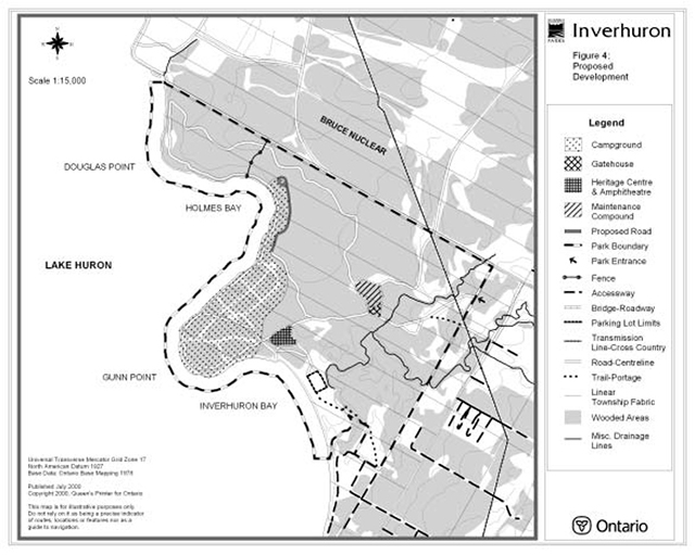
9.1 Campground
Subject to completion of a supportive business case and available funding, development of a campground will be considered. Design and development of a car campground, with an appropriate mix of electrical and regular sites, would be based on the pre-1976 development, but with far more spacing between sites.
A group campground development comprised of four areas with each area having four clustered sites will also be considered.
Pursuant to business plan approval, a reception centre housing registration, administration and Ontario Parks retail services would be constructed along the main entrance road. A maintenance compound would be developed off a restricted access road in the vicinity of the reception centre.
As an option to septic field beds, sewage may be disposed of outside the park through local facilities (e.g., sewage pumping chambers and a forcemain connected to the Bruce Nuclear waste management facility). Solid waste and recyclable materials would be disposed of through local municipal or private facilities.
Figure 4: Proposed Development of Inverhuron Provincial Park
Enlarge Figure 4: Proposed Development of Inverhuron Provincial Park
9.2 Roads
Park roads may be improved as required to accommodate peak traffic flows. A bicycle lane may be installed along the main feeder road into the park. Campground roads will be constructed over former road beds, wherever possible.
9.3 Day use area
Improvements would be made to the day use area to provide capacity for up to 240 vehicles.
Boardwalks and ramps will be maintained between the day use parking lot and the beach to protect sensitive sand dunes. Viewing platforms may be constructed on Gunn Point and the interior wetland.
The site of the boat launch may be relocated in light of wind and wave exposure and dredging requirements. Options may include enlarging, reorienting or relocating the ramp.
9.4 Trails
The redevelopment of the park roadway (formerly a scenic drive) into a barrier free, multi-use trail to provide travel linkages between the non-developed areas of the park, the campground, the shoreline and the park entrance will be considered.
A new walking trail may be developed in the northeastern portion of the park. Existing trails will be rationalized to determine if they are sited and aligned in an environmentally and culturally sensitive manner.
Boardwalks and bridges may be installed as required to cross wet areas and to protect sensitive natural or cultural values. In some cases, appropriate surface treatments may be applied in order to minimize trail user impacts.
A recreational trail link may be established between MacGregor Point and Inverhuron Provincial Parks in cooperation with local interest groups.
A trail plan may be prepared for the park to ensure the protection of cultural, archaeological and natural resources.
10.0 Implementation priorities
In the implementation of the approved park management plan, Ontario Parks may pursue opportunities for partnerships involving other agencies and groups. Park development, operations and resource stewardship will be contingent upon the availability of funding and unforeseeable changes in priorities or policy. Implementation of the management plan and operation of the park will meet the requirements of the Environmental Assessment Act, Environmental Bill of Rights, Provincial Parks Act and other pertinent legislation.
In order to implement the goals, objectives and direction set out in the approved park management plan, Ontario Parks will liaise with local First Nations, Ontario Power Generation, municipal government, government agencies, business and tourism associations, non-government organizations, park patrons, residents of the area, and others, as required. Ontario Parks may cooperate with individuals and groups through a variety of arrangements, including a cooperating association (i.e., Friends of Inverhuron Provincial Park), volunteers, and cooperating agreements.
Unless otherwise identified in this document, implementation priorities may be established in subsidiary operating and resource stewardship plans. Preparation of these plans may involve an appropriate level of public consultation.
To ensure the successful implementation and operational performance of the campground project, the development should be phased in at least three progressive stages. Doing so will permit Ontario Parks to plan the capital investment required to undertake the project over a period of years. The scheduling of the third stage will be dependent upon the successful operational performance of the second stage as well as the availability of capital funding. Operational performance will be evaluated against the achievement of the vision for the park set out in the approved park management plan as well as financial return.
It is important that the development of camping facilities proceed in sync with measures to protect and interpret the park’s rich and diverse cultural history and natural features. Additional visitor facilities may be desirable in the future (e.g., heritage centre). However, these will be addressed through individual business case assessments at the time that they are considered.
Ontario Parks is committed to completing an archaeological assessment of the entire park. A high priority will be placed on undertaking an archaeological assessment in potentially affected areas prior to any development. This will also include areas of existing or former park development.
Park development proposals would be phased in as follows:
Stage One
- conduct archaeological surveys of areas potentially affected by facility development
- prepare site and engineering plans for road and campground construction and layout of facilities on ground
- prepare facility development plans (site electrical, general lighting, utility source connections, comfort stations, mini comfort stations, vaults, garbage and recycling centre, trailer sanitary station, etc.); and
- secure agency approvals (hydro, water, sewer) and address environmental assessment requirements
Stage Two
- initiate day use area improvements
- develop first phase of campground (campsites complete with grill, table, post, permit holder) including parking lots and paved road system
- improve main road surface
- install general yard lighting (parking lots, comfort stations, entrance area)
- build comfort station (with showers and laundry facilities) and washrooms
- construct reception centre (registration, park store and administration)
- install sewage system
- install water supply, treatment and distribution system
- build garbage/recycling centre and trailer sanitary station; and
- post signage
Stage Three
- develop second phase of campground (campsites complete with grill, table, post, permit holder) including parking lots and paved road system
- install general yard lighting (parking lots, comfort stations, entrance area)
- build comfort station (with showers and laundry facilities) and washrooms
- install sewage system
- install water supply, treatment and distribution system
- build garbage/recycling centre
- post signage
- develop group camp area; and
- construct washrooms to service group camp area
11.0 Summary of public consultation
Public consultation was a very important part of the Inverhuron Provincial Park Management Plan review process. The four phases of the review consisted of:
- Phase 1 - Terms of Reference
- Phase 2 - Background Information, Issues and Options
- Phase 3 - Preliminary Management Plan
- Phase 4 - Approved Park Management Plan
Leading up to the formal public consultation process, meetings were held with the Chippewas of Saugeen and Nawash First Nations and several key stakeholder groups including Ontario Power Generation, Inverhuron & District Ratepayers Association, and the amalgamated Municipality of Kincardine. The purpose of those meetings was to explain the planning process, opportunities for public involvement and to identify concerns regarding management of the park.
Phase one consisted of the preparation of Terms of Reference. A news release was issued in August 1998, and the Terms of Reference were distributed to affected or interested groups and individuals. At that time a policy proposal notice was also posted on the EBR environmental registry.
Phase two focused on providing an opportunity for interested groups and individuals to review related background information. An open house held in Tiverton during October 1998, was advertised in local newspapers and in direct mailings. Approximately 50 people attended the open house. Additional contacts were made by telephone and in person.
Leading up to phase three and public release of the preliminary management plan, meetings were held with the Chippewas of Saugeen and Nawash First Nations and Ontario Hydro (now Ontario Power Generation).
In phase three, copies of the preliminary management plan were distributed in September 1999, to all groups and individuals identified during previous stages of the planning process. Direct mailings, a news release, paid advertisements in local newspapers, and a public meeting were used to encourage public involvement and comment. A policy proposal notice update was also posted on the EBR environmental registry.
Phase four culminated with the release of the approved park management plan in July 2000. Copies of the document were distributed to all those groups or individuals who contributed to the planning process. A policy decision notice was also posted on the EBR environmental registry.
The public was given a final opportunity to review the approved Management Plan for a period of forty-five (45) days after its formal release. This allowed interested participants in the planning program a final opportunity to determine if their concerns had been considered and addressed and to initiate an appeal concerning the plan contents where appropriate.
The management plan for Inverhuron Provincial Park may be reviewed to address changing issues or conditions. A mandatory review is to be held after 10 years. This may involve a reassessment of all or part of the plan, including classification, zoning, goal, objectives and all resource management, operations and development policies.
Ontario Parks will retain on file reference copies of relevant background information, Terms of Reference, Preliminary Management Plan and approved Park Management Plan.
12.0 References
Beechey, T. Inverhuron Provincial Park Inventory, August 23 to August 27, 1970. 1970.
Emerson, Bruce. Preliminary Report on Archaeological Interpretive Work at Inverhuron Provincial Park. 1972.
Emerson, Bruce, and Swaze, Ken. Final Report on Archaeological Interpretive Work at Inverhuron Provincial Park. 1972.
Findlayson, William D. The 1972 Excavations at the Inverhuron - Lucas Site. A Preliminary Report. 1972.
Fitzgerald, Bill. Inverhuron Provincial Park Development Area 1: Overview of Archaeological Activities, October-November 1999. 2000.
Fitzgerald, Bill. A Stage 2 Archaeological Assessment of Area 1 (Development Area), Inverhuron Provincial Park, Bruce Township, Bruce County. 2000.
Gibbard, H. Inverhuron Provincial Park Check Sheet for Survey of IBP Areas. 1970.
Harvey, E.T. Earth Science Inventory, Inverhuron Provincial Park. Ontario Ministry of Natural Resources, Division of Parks, Toronto, 1976.
Helling, N., Lichtenfeld, D., and Harvey, L. International Biological Programme, Checksheet for Region 5, Area 224: Inverhuron. Parks Planning Branch, Ministry of Natural Resources, Toronto, 1970.
Hill, Alan. Montreal River and Inverhuron Sites: Environmental Considerations. (undated).
Johnson, J. and Parker, M. Annotated Checklist of the Vascular Plants of Inverhuron Provincial Park. Ministry of Natural Resources, Owen Sound, 1975.
Johnson, Joseph W. Botanical Inventory of Inverhuron Provincial Park. Ministry of Natural Resources, Owen Sound, 1981.
Kenyon, Walter. The Inverhuron Site. Occasional Paper 1. Art and Archaeology Division, Royal Ontario Museum, Toronto, 1959.
Lee, Thomas E. The Lucas Site, Inverhuron, Ontario. National Museum of Canada, Bulletin No. 107, Contributions to Anthropology. 1958.
Ontario Ministry of Citizenship, Culture and Recreation. Conserving a Future for Our Past: Archaeology, Land Use Planning & Development In Ontario - An Educational Primer and Comprehensive Guide for Non-Specialists. Cultural Programs Branch, Archaeology and Heritage Planning Unit, 1997.
Ontario Ministry of Natural Resources. A Topical Organization of Ontario History. Division of Parks, Historical Sites Branch, 1975.
Ontario Ministry of Natural Resources. Caring for History - A Handbook for Managing Cultural Resources in Ontario Provincial Parks. Provincial Parks and Recreational Areas Branch, Toronto, 1982.
Ontario Ministry of Natural Resources. Economic Impact of Provincial Parks in Ontario: A Summary Report (1992). Provincial Park Operations Section.
Ontario Ministry of Natural Resources. Environmental Assessment in Ontario Provincial Parks: An Interim Field Reference for Staff, Revised Edition. Corporate Policy and Planning Secretariat, Huntsville, 1994.
Ontario Ministry of Natural Resources. Inverhuron Provincial Park Future Management Proposal. 1975.
Ontario Ministry of Natural Resources. Inverhuron Provincial Park Management Plan. Owen Sound, 1985.
Ontario Ministry of Natural Resources. MNR: Direction ‘90s. Toronto, 1992.
Ontario Ministry of Natural Resources. MNR: Direction ‘90s…Moving Ahead, 1995. Toronto, 1994.
Ontario Ministry of Natural Resources. Ontario Parks Business Plan. Peterborough, 1996.
Ontario Ministry of Natural Resources. Ontario Provincial Park Management Planning Manual. Provincial Operations Branch, Provincial Parks Operations Section, Peterborough, 1994.
Ontario Ministry of Natural Resources. Provincial Parks Act, Revised Statutes of Ontario, 1990.
Ontario Ministry of Natural Resources. Ontario Provincial Parks Planning and Management Policies. Parks and Recreational Areas Branch, Toronto, 1978.
Ontario Ministry of Natural Resources. Ontario Provincial Parks: Planning and Management Policies, 1992 Update. Natural Heritage Policy Branch, Toronto.
Ontario Ministry of Natural Resources. Owen Sound District Land Use Guidelines. Owen Sound, 1983.
Ontario Parks. Park Statistics - Statistiques Parcs. Peterborough. 1999.
Ramsden, Peter. Archaeological Work at In Inverhuron Provincial Park, 1969. 1969.
Ramsden, Peter. Proposal for Continuation of Archaeological W ork in Inverhuron Provincial Park, 1970. 1970.
Ramsden, Peter. Proposed Archaeological Research In Inverhuron Provincial Park, Ontario. 1969.
Ramsden, Peter. Progress Report to the Canada Council on the Rocky Ridge Site (BbHj-16)x Inverhuron, Ontario. 1970.
Ramsden, Peter. Report on a Survey of Inverhuron Provincial Park, September, 1970. 1970.
Ramsden, Peter. The Inverhuron Archaic. 1970. Ramsden, Peter. The Inverhuron Archaic. A Preliminary Report on the 1970 Season. 1970.
Savage, Howard. Inverhuron - Faunal Analysis. (undated).