Island Lake Forest and Barrens Conservation Reserve Management Statement
This document provides policy direction for the protection, development and management of the Island Lake Forest and Barrens Conservation Reserve and its resources.
Statement of Conservation Interest
June 2002
Ministry of Natural Resources
Parry Sound District
Prepared with the assistance of:
Meteek & Company
Huntsville, Ontario
Approval statement
We are pleased to approve this Statement of Conservation Interest for the Island Lake Forest and Barrens Conservation Reserve.
The conservation reserve is located about 45 kilometres north of the Town of Parry Sound and about 11 kilometres northwest of the hamlet of Dunchurch. Situated between the Magnetawan River to the south and the Pickerel River to the north, it extends from the north shore of Wahwahkesh Lake north about 11 kilometres, encompassing all of Island Lake. Located in the Territorial District of Parry Sound, the southern portions of the site lie within the Municipality of Whitestone, while the northern portions are unincorporated.
This 15,475 hectare conservation reserve is one of the most diverse natural areas in Hills' ecological Site District 5E-7. It encompasses large areas of relatively remote pristine coniferous and tolerant hardwood forest and rock barrens habitat. Owing to its size, the conservation reserve contains a diversity of botanical and wildlife habitats. The area includes a number of species of Atlantic Coastal Plain flora, some of which are provincially rare. It provides suitable habitat for threatened herpetological species, (Eastern Massasauga Rattlesnake, Eastern Hognose Snake) and species of Special Concern (Spotted Turtle, Five-lined Skink). It appears to be the most northern extension of the range of the Five-lined Skink.
Island Lake Forest and Barrens Conservation Reserve is one of 378 new protected areas approved through Ontario’s Living Legacy Land Use Strategy, aimed, in part, at completing Ontario’s system of parks and protected areas.
During the "Lands for Life" planning process, the public was widely consulted and provided valuable input into what became Ontario’s Living Legacy Land Use Strategy. Comments received during that time, and during consultation related to the formal Public Lands Act regulation of the boundaries of this conservation reserve, were generally supportive of the protection of this area. Stakeholders who provided comment during the boundary consultation for this site were subsequently consulted regarding the draft Statement of Conservation Interest and their comments were considered in the finalization of this document.
This Statement of Conservation Interest provides guidance for the management of the conservation reserve and provides the basis for the ongoing monitoring of activities. More detailed direction is not anticipated at this time. Should more complex resource management or conservation issues arise or significant facility development be considered, then a detailed Resource Management Plan will be prepared with full public consultation.
The Island Lake Forest and Barrens Conservation Reserve is managed under the direction of the District Manager and the Parry Sound Area Supervisor of the Ministry of Natural Resources, Parry Sound District.
Approved by:
R. Griffiths District Manager
Parry Sound District
And
Approved by:
G. Ross
Regional Director
Southcentral Region
1.0 Introduction
Ontario’s Living Legacy, the result of an extensive planning process that began in early 1997, culminated in the approval in July 1999 of a Land Use Strategy that identifies the intended strategic direction for Crown land, including the completion of Ontario’s system of parks and protected areas. This process, which included extensive public consultation, resulted in the recommendation for regulation of 378 new protected areas, including the Island Lake Forest and Barrens Conservation Reserve.
The Island Lake Forest and Barrens Conservation Reserve is located in the Territorial District of Parry Sound. The southern half is within the Municipality of Whitestone, while the northern half is unincorporated. The conservation reserve extends from the Magnetawan River and Wahwashkesh Lake in the south, north to the northern shores of Dog Lake and Otter Lake. The reserve consists of 15,475 hectares of Crown land, mostly in the north half of McKenzie Township and the south half of Wilson Township, with small areas extending westward into Burton and Brown Townships.
This conservation reserve is a part of a larger area that has been considered, since at least the 1970's, as having significant wilderness values. In recognition of these wilderness and backcountry recreation values, the Parry Sound District Land Use Guidelines (OMNR 1983) designated an extensive area as the Parry Sound Wildlands. Those portions of the conservation reserve lying in Concessions 4, 5, 6 and 7 in Wilson Township, all portions in Brown and Burton Township, and Lots 29 to 35, Concession 12, McKenzie Township were part of the Parry Sound Wildlands land use designation.
Since the approval of the 1983 Parry Sound District Land Use Guidelines (DLUGs), the Ministry of Natural Resources (MNR) has managed this area "to provide both opportunities for wilderness-like recreation and tourism, and opportunities for resource development and use, and to protect significant natural features". Within the Parry Sound Wildlands, public access for recreation and tourism purposes is restricted to trails existing in 1983 and associated means of travel and to boat-in, fly-in or walk-in means.
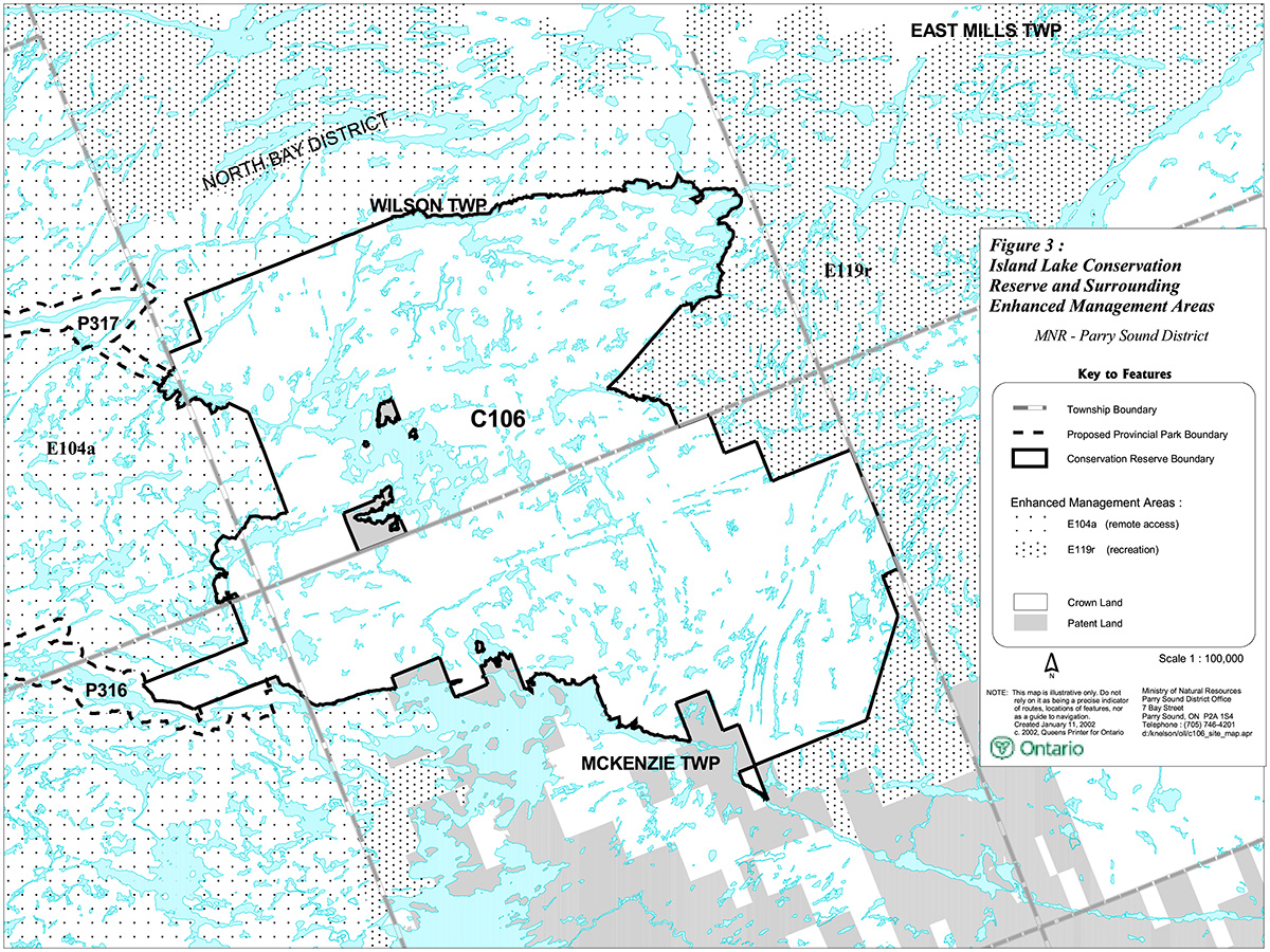
With the approval of the Ontario’s Living Legacy Land Use Strategy in 1999, the Parry Sound Wildlands land use policies were carried forward into the Land Use Strategy and these lands are now part of the Strategy’s Enhanced Management Area E104a (Parry Sound Interior Remote Access Area). Where these restricted access policies are more restrictive than the conservation reserve policy, then the E104a land use policies shall prevail for that portion of Island Lake Forest and Barrens Conservation Reserve that was formerly part of the 1983 Parry Sound Wildlands (see Figure 2).
Areas adjacent to the Island Lake Forest and Barrens Conservation Reserve were also recognized in the Ontario Living Legacy Land Use Strategy. The proposed Magnetawan River Provincial Park (P316) abuts this reserve to the south-west, and the proposed Noganosh Lake Provincial Park (P317) is linked with it to the north-west. The conservation reserve is surrounded by two Enhanced Management Areas: E104a, (Parry Sound Interior); and E119r, (North Parry Sound Area) which are intended to maintain or enhance the remote recreation qualities of these areas while permitting compatible resource management. Together with the Island Lake Forest and Barrens Conservation Reserve, these additional protected areas and enhanced management areas all emphasize the wilderness-like recreation, and remote access values of the general area.
Conservation reserves are established by regulation under the Public Lands Act. The Island Lake Forest and Barrens Conservation Reserve was established by Ontario Regulation 461/00, under the authority of the Public Lands Act (O. Reg. 805/94) on August 10, 2000.
A Statement of Conservation Interest (SCI) is prepared under the authority of Procedural Guideline A - Resource Management Planning (PL. Procedure 3.03.05). The purpose of this SCI is to identify and describe the values of the Island Lake Forest and Barrens Conservation Reserve. The SCI also outlines the activities that currently occur within the conservation reserve and provides guidelines for the management of current and future activities in the context of protecting the natural, recreational and cultural values.
At the time that this Statement of Conservation Interest was being prepared, the MNR was in the process of making administrative corrections to the conservation reserve boundary in two locations:
- in the northern portion of the peninsula in Lot 24, Concession 4 (southwest section), Wilson Township and
- Lot 4, Concession 6, Wilson Township, north of Dog Lake
The corrections were proposed for the following reasons:
- To exclude a piece of patent land from the conservation reserve to correct a tenure error made by the MNR during preparation of the regulation plan
- To correct the boundary on the regulation plan to accurately reflect the original intent of the conservation reserve to include only the lands extending 60 metres back from the northern water’s edge of Dog Lake
1.1 Background information
| Name | Island Lake Forest and Barrens Conservation Reserve |
|---|---|
| Site Region/District OMNR Administrative Region/District/Area | Georgian Bay 5E-7 Southcentral Region/Parry Sound District/Parry Sound Area |
| Total Area (ha.) | 15,475 hectares |
| Regulation Date | August 10, 2000 (O. Reg. 461/00) |
| First Nations | Robinson-Huron Treaty |
| OBM map sheets | 20 17 5700 50600, 20 17 5700 50700 |
| Topographic Map | Noganosh 41H/9 |
| UTM coordinates | 17T 576000 5071000 (Centroid) |
1.2 Representation
Earth science representation:
Bedrock:
Britt domain, Algonquin Terrane, and Parry Sound Domain, Parry Sound Terrane in the northwestern part of the Proterozoic Central Gneiss Belt of the Grenville Province.
Dominant rock types are felsic and mafic metaplutonic and metasedimentary rocks and other gneisses of indeterminate protolith.
Surficial:
Thinly soiled bedrock plains on the west side, extensive bedrock barrens on the east.
Heavily influence by glacial scouring, followed by erosion and reworking by receding waters of post-glacial Lake Algonquin.
Life science representation:
- Coniferous forests of predominately white pine, red pine and eastern hemlock over thin soils on bedrock plains with stands of tolerant hardwoods on deeper soils in the west, open bedrock barrens in the east with strong representation of jack pine. Organic soils and sandy deposits in lower and flatter areas, with a network of bogs, wetlands, peatlands and ponds
- A wide variety of representative combinations of vegetation and landforms
- Several species of Atlantic Coastal Plain flora, some nationally and/or provincially rare
- Confirmed populations of Five-lined Skink (Eumeces fasciatus ), which is a COSEWIC
footnote 1 species of "Special Concern" - Abundant suitable habitat for Eastern Massasauga Rattlesnake (Sistrurus catenatus catenatus; COSEWIC - Threatened) although no confirmed sightings to date. Also habitat for Eastern Hognose Snake (Heterodon platirhinos; COSEWIC - Threatened) and Spotted Turtle (Clemmys guttata; COSEWIC - Special Concern)
Cultural resources representation:
Neither detailed research nor inventory has been carried out for this conservation reserve. However, there is some site evidence of early logging activity, dating as early as the late 19th century.
Recreational opportunities:
A recreational inventory report was prepared for this site based on existing knowledge of MNR staff and several consultants (Heidman & Parent, 2002). No additional specific studies have been done. The area is recognized as providing wilderness-like recreation opportunities. It accommodates sport fishing, big and small game hunting, canoe tripping, and snowmobiling. All-terrain vehicle use is becoming increasingly common. Sixteen recreation camps, authorized by MNR through the Public Lands Act, are located within the conservation reserve.
1.3 Survey work
| Survey Level | Earth science | Life Science | Cultural | Recreational | Other |
|---|---|---|---|---|---|
| Reconnaissance | Noble, 1983; Frey & Duba, 2000 | Dickson,1978; Blythe & Assoc., 2001 | None | Heidman & Parent, 2002; (Inventory Report) | None |
| Detailed | Hough, Stansbury & Michalski Ltd., 1982; Keddy & Sharp, 1989 | None | None | None | |
| Requirement | None | Monitor the status/presence of significant species and associations. | Research to be encouraged. | Monitor use impacts | None |
2.0 Values to be protected
The conservation reserve is located entirely within Hills' (1959) ecological Site District 5E-7. Values include earth science, life science and recreational/aesthetic values, with an emphasis on the life sciences.
2.1 Earth science:
Bedrock:
Island Lake Forest and Barrens Conservation Reserve is a large, low relief area of extensive bedrock barrens. The dominant rock types are felsic and mafic metaplutonic and metasedimentary rocks and other unclassified gneisses (Frey & Duba, 2000). T bedrock is part of the Britt Domain, Algonquin Terrane, and the Parry Sound Domain, Parry Sound Terrane in the northwestern part of the Proterozoic Central Gneiss Belt of the Grenville Province.
The Grenville Province is the product of thrusting and imbrication of the earth’s crust to the north-west as it collided with a continental land mass to the south-east. The Grenville Orogeny, circa 1140 to 1070 million years ago, culminated more than 500 million years of crustal evolution. The eroded rocks of the products of these events are displayed in the complexly metamorphosed and deformed rocks of the region (Easton, 1992b).
The Algonquin and Parry Sound Terranes are two of the four lithotectonic terranes of the Central Gneiss Belt. Within the Algonquin Terrane, the Britt Domain is one of twelve structural domains. The Parry Sound Domain is one of three structural domains of the Parry Sound Terrane. These geological environments are part of the modern organization of the complex products of the mid-Proterozoic orogenic events (Easton 1992a & b). As such, their representation in the Island Lake Forest and Barrens Conservation Reserve contributes to the conservation of the Grenville Province continental accretion theme (Davidson, 1981).
The geological features of the conservation reserve are of regional significance in the representation of plutonic and supracrustal components and other complexities of the Britt Domain, Algonquin Terrane, and the Parry Sound Domain, Parry Sound Terrane (Frey & Duba, 2000).
Surficial:
The Island Lake Forest and Barrens Conservation Reserve lies mostly in moderately broken shallow sandy till uplands. Its topography features rugged steep hills of granite bedrock that have been heavily influenced by glacial scouring, followed by erosion and reworking by the receding waters of post-glacial Lake Algonquin. Combined with early logging activities and several large forest fires, these factors have resulted in the thin glacial soils of Monteagle Gravelly Sand Complex (Hoffman et al. 1962) on the west side of the site, and the bedrock barrens of the east side. Drainage characteristics are determined by the local patterns of geological faults, with many of the smaller watercourses following fault lines. Many of the local drainage outlets are subject to beaver damming with the result that the landscape is dotted with numerous small lakes and ponds.
2.2 Life science:
The conservation reserve is located within Hills' (1959) ecological Site District 5E-7. Life science significance is determined on the basis of the following criteria: representation, diversity, condition, ecological considerations and special features (Crins and Kor 1998).
Representation:
The conservation reserve encompasses a large area of relatively remote pristine coniferous forest and rock barrens habitat, and includes a wide variety of wetland features (Blythe & Associates, 2001).
The western portions of the conservation reserve support primarily coniferous forests growing on the thin glacial till soils. The dominant species are white pine, red pine and eastern hemlock (Blythe & Associates, 2001). Valleys, with higher soil moisture regimes, support some deciduous and mixed wood forests, including sugar maple, red maple, yellow birch, black ash, balsam fir, white spruce and eastern hemlock. The forests of the western portion of the conservation reserve are generally large and mature. They have not been impacted by recent logging operations; however, there is some evidence of fires throughout the forest.
In the eastern portions of the conservation reserve, the forest is in an early successional state (Blythe & Associates, 2001). The predominant species found here, generally in the valleys between bare bedrock hills, are largetooth aspen, red maple, white birch and trembling aspen. Species composition of the rock barrens is influenced by the lack of soil and consequent lack of retained moisture, and the exposure to desiccating winds. Typically these areas are colonized by stunted trees such as white birch, red pine and jack pine. Shrubs and herbaceous plants in this zone are usually confined to small pockets of soil in sheltered microclimates. These plants are almost exclusively represented by three species: low sweet blueberry, sweet fern, and crinkled hair grass. These areas also indicate a history of forest fires.
Many of the low-lying areas between the bedrock hills are occupied by various types of wetlands; graminoid meadows and ericaceous swamps are the most common, with a scattering of tall shrub swamps.
Several locations around Wahwashkesh Lake and Island Lake are provincially renowned for the presence of Atlantic Coastal Plain plant species, including several rare species (particularly on Island Lake).
The Five-lined Skink (Eumaeces fasciatus ), Ontario’s only lizard, has been confirmed within the conservation reserve, as has the Eastern Hognose Snake (Heterodon platirhynos ). The reserve contains suitable habitat for the Eastern Massasauga Rattlesnake (Sistrurus catenatus catenatus ) and the Spotted Turtle (Clemmys guttata) which have been recorded in the general vicinity, but not within the reserve boundaries.
Condition:
This area shows evidence of late 19th and early 20th century logging, but there has been no recent timber harvest activity. The area and its surroundings show evidence of a history of extensive forest fire activity, mostly in the first half of the twentieth century.
Access has traditionally been limited. The conservation reserve is not accessible by road, except for an old "tote road" from Deep Bay on the Magnetawan River. This route is now a trail and has historically provided access to a parcel of private land on southern Island Lake; it is now used by all-terrain vehicles and snowmobiles. Access to the site is also gained by air transport to Island Lake and by a number of difficult canoe routes.
Recently, additional access has been developed via two snowmobile trails which traverse the conservation reserve (See Section 2.4) By providing bridge access across the Magnetawan River, they have enabled the expansion of all-terrain vehicle use within the conservation reserve, with the development of a number of unauthorized trails (Blythe & Associates, 2001).
Some of the wetland areas show damage where they have been traversed repeatedly by all-terrain vehicles (Blythe & Associates).
Diversity:
This is one of the most diverse natural areas in ecological Site District 5E-7. It contains roughly 36 different representative combinations of vegetation and landforms, and consequently a large diversity of botanical and wildlife habitats. White pine forests over thin soils on bedrock plains dominate the west side of Island Lake, especially along lakeshores, while open bedrock barrens are most common east of the lake (Blythe & Associates, 2001). Much of the site shows scouring and erosion from glaciers and the receding waters of post-glacial Lake Algonquin. Some of the other forest habitats include hemlock, poplar, red an d silver maple, sugar maple, white pine and older jack pine forests growing on shallow sand. There are also open stands of pine, white birch, red maple and oak with shrubs and lichens as undergrowth in the burned-over areas to the east of Island Lake. Filling the flat areas between the bedrock uplands and outcroppings are organic soils and sandy soils with a network of bogs, wetlands, peatlands and ponds. Of particular note is the presence of Atlantic Coastal Plain flora on the shores of Island Lake and several other shorelines, and the habitats of a number of herpetofaunal species, noted earlier in this section.
Ecological considerations:
Although previously controlled, Island Lake itself is unregulated by any dams, and supports, along with other water bodies in the reserve, post-glacial relict populations of Atlantic Coastal Plain flora. These species are thought to have migrated from the coastal plain of the United States approximately 11,000 years ago, during the time when post-glacial Lake Algonquin covered an extensive area east of Georgian Bay. (Keddy & Sharp, 1989) Regulation of these water bodies through water control structures would threaten these species, which require seasonal water level fluctuations to sustain their populations. As some of these species are sensitive to trampling and motorized vehicle use, significant increases of shoreline use (e.g. camping) may also pose a threat to their shoreline habitat. There is presently some manipulation of water levels as a result of beaver dams at the outlet into Farm Creek on the site of an old logging era stone and crib dam.
Special features:
Besides the diversity of a wide variety of vegetation/landform combinations, this site is noted for:
- Numerous occurrences of Atlantic Coastal Plain species, including many of the rarer members of this group (e.g. Snail-seed pondweed - Potamogeton bicupulatus, Tuckerman’s [Algal-leaved] pondweed - P. confervoides, Carey’s Smartweed - Polygonum careyi, Small Beggar-ticks - Bidens discoidea, Hairy Panic Grass - Panicum acuminatum, Virginia Meadow Beauty - Rhexia virginica, Humped Bladderwort - Utricularia gibba and Yellow-eyed Grass - Xyris difformis) (Blythe & Associates, 2001)
- Confirmed presence of the Eastern Hognose Snake (Heterodon platirhynos ; COSEWIC- Threatened) and the Five-lined Skink, (Eumaeces fasciatus; COSEWIC - Special Concern) Ontario’s only lizard
- The abundance of suitable habitat for the Eastern Massasauga Rattlesnake (Sistrurus catenatus catenatus; COSEWIC - Threatened) and the Spotted Turtle (Clemmys guttata; COSEWIC - Special Concern) both of which have been recorded in the general vicinity, but not within reserve boundaries
- The rock barrens in the east of the reserve show evidence of heavy winter browsing by moose. The plentitude of blueberries on the barrens and cranberries in the low-lying areas provides summer/fall food resources for black bear (Blythe & Associates, 2001)
2.3 Cultural values:
While no specific studies or inventories have been undertaken within the reserve, and no major cultural resource values have been evaluated or identified to date, there is anecdotal and physical evidence of early logging throughout this conservation reserve, and other evidences of early 20th century use of area (Blythe & Associates).
During their field investigation of the Island Lake area in September 2001, Blythe and Associates noted a variety of relicts related to early logging throughout the area. These include remnants of a rock crib dam which once blocked the outlet flow of Farm Creek and a large impeller turbine abandoned on the on the west side of the creek bed, downstream of the dam. An old tote road linking Deep Bay on the north shore of Lake Wahwashkesh with Island Lake is believed to have been constructed to service logging operations on Island Lake. This road has several abandoned vehicles and a variety of logging paraphernalia scattered at various locations along its length. A wooden fire tower is known to have been located on the summit of Tower Island (Heidman & Parent , 2002).
Given the proximity of the conservation reserve to Wahwashkesh Lake and the Magnetawan River, it is highly likely that this area was once used as a travel way for First Nations.
2.4 Recreational/aesthetic values:
The wilderness values of this site are enhanced by the substantial distance to publicly maintained roads, by the limited development in the area, and by the pristine night sky. The long tradition of wilderness-type recreation in and around the conservation reserve is reflected in the current land use direction for this area, and was also reflected in the direction set in place in 1983 (Parry Sound District Land Use Guidelines) when some of the site was included in the Parry Sound Wildlands (see Figure 2).
This area has traditionally been used for sport fishing and hunting as well as canoe tripping and general nature activities. There are two snowmobile trails crossing through the reserve in a general north-south direction. One is a historically existing trail (Cramadog Snowmobile Club’s Trail 600) and the other is a Trans-Ontario Provincial feeder trail (TOPS D102C) which was approved in 1993.
At least three outfitters provide fly-in service to Island Lake, to a commercial lodge, private lodges, recreation camps, and other users.
Island Lake is considered a significant canoe-in destination, with connections to Wahwashkesh Lake via Farm Creek and Wolf Lake; to Noganosh Lake via Kelsie Lake; and also to the Pickerel River canoe route via Noganosh Lake. These are not easy or heavily used canoe routes, due to the abundance of portages and normally low summer water levels. Given that these water bodies will become included in various new Ontario’s Living Legacy provincial parks and conservation reserves, use of these water bodies is likely to increase as public awareness increases.
All-terrain vehicle use of the reserve has increased in recent years, with access gained by way of the snowmobile trails and other old trails. A number of informal all-terrain vehicle trails have developed, some of which may be in conjunction with a number of authorized recreation camps within and near the reserve.
3.0 Management guidelines
3.1 Land tenure
Background:
Island Lake Forest and Barrens Conservation Reserve comprises 15,475 hectares of Crown land, and most of the area adjacent to it is also Crown land. It borders some parcels of private land along the north shore of Wahwashkesh Lake and the Magnetawan River, and it surrounds several parcels of private land on Island Lake. These private parcels, although adjacent to or surrounded by conservation reserve boundaries are, themselves, not part of the conservation reserve. With minor exceptions adjacent to private land parcels, concession road allowances (but not shoreline road allowances) within the portion of the reserve now in an incorporated municipality were stopped up and closed in December 1999, by Order In Council 2397/99. These closed road allowances are part of the conservation reserve.
The reserve includes portions of six registered traplines (PS-02N13501, PS-02N13301, PS-02N13401, PS-02N06601, PS-07N04301, PS-06N04401), and there are two trapper cabins associated with these. The reserve also includes portions of three Bear Management Areas (PS-47-14, PS-47-15, and PS-47-16). Bait Fish Blocks, which extend into the conservation reserve, are currently unassigned.
There are currently 16 recreation camps located within the conservation reserve, authorized under the authority of the Public Lands Act.
Two snowmobile trails (see Section 2.4) are authorized by land use permit.
Boat caches exist on several lakes within the reserve. Some are authorized by letter of authority, but there are also several unauthorized private boat caches.
Guideline:
The sale of Crown lands within the conservation reserve is generally not permitted. Exceptions will only be considered under unusual circumstances, such as where an adjacent privately owned parcel has inadequate area for the installation of a septic system.
There are no plans by the MNR to acquire private lands to add to the conservation reserve.
Fur harvest will continue in the registered trapline areas. The commercial bear hunting service associated with the current Bear Management Areas is allowed to continue. The Bait Fish Blocks are currently unassigned, and will be re-assigned to future applicants.
Authorized commercial boat caches can continue. However, private boat caches are not allowed to occupy Crown land without authorization. They will be phased out of the conservation reserve.
Existing recreation camps are permitted to continue. They may be eligible for "enhanced" tenure, but are not eligible for purchase of land. There are 2 forms of enhanced tenure that may be considered (as per September 22, 2000 direction from MNR's Assistant Deputy Ministers of Natural Resource Management and of Field Services):
- upgrade in the nature or type of tenure (e.g. from a Land Use Permit to a lease); and/ or
- an extension in the term of the tenure (e.g. from 1 year to 10 years)
Applications for enhanced tenure will be approved if determined acceptable using the following screening criteria:
- Must follow the review process identified in MNR's land disposition policies:
- MNR District Manager must ensure that there will be no serious, foreseeable resource management or user conflicts as a result of the enhanced tenure
- The intended use/activity will not likely impact on Goal 1, 2 or 3 of the Provincial Policy Statement, issued under Section 3 of the Planning Act
- The site conforms with the MNR's land use planning direction
- The disposition is reviewed under the Environmental Assessment Act’s Exemption Order MNR 26/7
- The site is not within a Provincial Significant Wetland (PSW). If the site is adjacent to a PSW it must be determined that the proposed enhancement of tenure will not have a negative impact on the function or natural features of the wetland
- If the site is on lake trout lake, a lease will only be considered after such time as the policy on development on such lakes has been approved
- Would not result in increased negative impact on natural heritage, cultural heritage or recreational values of the conservation reserve, or on existing authorized land uses
- Must be subject to consultation with affected First Nations, and be consistent with any aboriginal land claim negotiations or protocol agreements
- All rents, taxes, fees, rates or charges must be paid up
A change in tenure does not convey a commitment to provide for, or agree to, a change in the type or the standard of existing access to the recreation camp.
New recreation camps are not permitted.
3.2 Development
Background:
There are no Crown owned buildings or other facilities within the conservation reserve. The private recreation camps, trapline cabins and commercial outpost camps have various small buildings and facilities associated with them. Two snowmobile trails (see Section 2.4) pass through the conservation reserve. There are also a number of unauthorized all-terrain vehicle trails, some associated with recreation camps, and others that appear to be the result of increased access to the area facilitated by the snowmobile bridge across the Magnetawan River. Otherwise, the only signs of development are relicts from the early logging era, including the old tote road from Deep Bay on the Magnetawan River to the south-western corner of Island Lake.
As discussed in Section 1, the north and west portions of this conservation reserve lie within an area of Crown land that has been managed since 1983 as the Parry Sound Wildlands. This area has been managed "to provide both opportunities for wilderness-like recreation and tourism, and opportunities for resource development and use, and to protect significant natural features". (OMNR 1983) Public access for recreational and tourism purposes in this portion of the conservation reserve has traditionally been limited to existing trails and associated means of travel, and to boat-in, fly-in or walk-in means.
Guideline:
The Parry Sound Wildlands direction from the District Land Use Guidelines, in place since 1983, will continue to apply to the portions of the conservation reserve within the Wildlands.
New roads for resource extraction and/or private use will not be permitted, nor will additions to existing roads, or up-grading of existing roads be permitted. The only exception would be that new roads necessary to enable mineral exploration and development of mining claims and leases outside of the conservation reserve are permitted, with appropriate consideration for the protection of conservation reserve values.
No mineral exploration is permitted within this conservation reserve. This direction is based on a commitment made by the Ministry of Natural Resources and the Ministry of Northern Development and Mines in the spring of 2002. This direct ion replaces that identified in the 1999 Ontario’s Living Legacy Land Use Strategy, which stated that controlled mineral exploration would be permitted in new conservation reserves which were identified as having provincially significant mineral potential.
Existing snowmobile trails may be permitted to continue in conservation reserves as long as they do not impair the natural features and values for which the area is identified and as long as there are no significant environmental impacts. Accordingly, the two approved snowmobile trails will continue to be authorized as long as they are a part of the provincial and regional trails systems, but their use will be monitored to ensure that that conservation reserve values are not being adversely impacted. Additional snowmobile trails or all-terrain vehicle trails are not encouraged, but may be considered on a case by case basis, except within the former Parry Sound Wildlands portion of the conservation reserve. Public consultation will be an important part of the consideration of any new trails which would also be required to comply with Procedural Guideline B - Land Uses - Test of Compatibility (Appendix A).
The use of existing unauthorized recreation trails will be monitored to ensure that conservation reserve values are not being adversely impacted. Depending on the results of monitoring, some of the unauthorized trails may need to be redirected from sensitive areas or eliminated completely. Otherwise, there is no intent to mark or upgrade these trails.
New trails, or up-grading of existing trails, is not permitted within the former Parry Sound Wildlands portion of the conservation reserve.
While there is no intent at present to provide or permit any new development in this conservation reserve that would require lighting, should this be considered at some point in the future the MNR will have regard to minimizing unnecessary undirected light pollution. This commitment recognizes the wilderness values provided by a pristine night sky.
3.3 Recreational activities
Background:
Existing recreational uses include sport fishing and hunting, canoe tripping, camping, snowmobiling, all-terrain vehicle use and general nature activities.
Sport fishing, a significant activity on Island Lake, focuses on smallmouth and largemouth bass, and to a lesser extent, walleye. Most hunting activity in the conservation reserve focuses on white-tailed deer, moose and black bear.
Guideline:
Consistent with the Land Use Strategy, sport fishing and hunting are permitted to continue within the conservation reserve.
Canoe tripping and camping are also permitted to continue. Based on the results of future monitoring and the need to protect sensitive natural heritage values like Atlantic Coastal Plain vegetation, the MNR will consider prohibiting certain activities (like camping, day use and trails) at specific sites. This would be carried out under the authority of the Public Lands Act.
Recreation use such as hiking, wildlife viewing, snowshoeing, and cross-country skiing, while currently very limited in extent and therefore not managed, will be allowed to occur in the conservation reserve.
The existing authorized snowmobile trails can continue as long as they are a part of the provincial and regional trails systems, but their use will be monitored to ensure that the conservation reserve values are not being adversely impacted. While not encouraged, additional snowmobile trails or changes to the existing routes may be considered on a case by case basis (except in the Parry Sound Wildlands), provided they meet the Procedural Guideline B -Test of Compatibility (Appendix 1) and the MNR's Environmental Assessment Act requirements. New all-terrain vehicle trails would be subject to the same limitations and considerations.
Existing unauthorized all-terrain vehicle trails will be monitored as discussed under Section 3.2, and some may need to be redirected from sensitive areas or eliminated completely. Otherwise, there is no intent to mark or upgrade these trails.
New trails, or up-grading of existing trails, is not permitted within the former Parry Sound Wildlands part of the conservation reserve.
New recreational activities will be considered on a case by case basis provided they are consistent with maintaining the values of the conservation reserve and comply with Procedural Guideline B - Land Uses - Test of Compatibility (Appendix 1). Emphasis will be placed on activities that have a low impact on the environment of the conservation reserve.
3.4 Commercial activities
Background:
There has been no recent commercial forest harvesting or mining activity within the conservation reserve.
Commercial fur harvesting is authorized through registered traplines. The guiding of non-resident bear hunters is authorized through Bear Management Areas, and bait fish harvesting is authorized through Bait Fish Block licenses (although currently none are assigned) within the conservation reserve.
Boat caches, associated with commercial fly-in services, are authorized through letters of authority.
Guideline:
Fur harvest, bear hunting services and bait fish harvesting operations will be allowed to continue within the conservation reserve, as will the use of existing commercial boat caches.
Conservation reserve regulations do not permit mining, commercial forest harvesting, hydroelectric power development, the extraction of aggregate and peat or other industrial uses (Public Lands Act, Ontario Regulation 805/94). Other new commercial activities must meet the requirements of Procedural Guideline B (see Appendix 1).
No mineral exploration is permitted within this conservation reserve, as is discussed in Section 3.2.
3.5 Aboriginal interests
Background:
This site is located within the Robinson - Huron Treaty Area of 1850, and as such the general area of this conservation reserve is known to be of interest to various First Nations. During the 1999 consultation process for the refinement of the boundary for this conservation reserve, Ministry staff discussed this conservation reserve with representatives of the First Nation communities on the eastern Georgian Bay coast. The draft Statement of Conservation Interest was also discussed with several First Nation representatives.
Guideline:
The regulation and management of this conservation reserve will not impede the exercise of existing aboriginal or treaty rights. These rights include hunting, fishing, trapping, gathering of plants for a variety of purposes, and the use of ceremonial sites.
3.6 Natural resource stewardship
Vegetation management for specific purposes (other than historic logging) is not known to have occurred in the past. Wildlife and fisheries management, particularly sport fishing, hunting and trapping, have been occurring according to the prevailing policies and legislation (as discussed in Section 3.3).
The emphasis will be on ensuring that the natural values of the conservation reserve are not negatively affected by current and future activities. Therefore, applications for new specific uses will be carefully studied and reviewed. The Ministry, partner organizations, and/or proponents may undertake such studies.
Guideline - Vegetation:
The intent of this site is to allow the existing vegetation communities to evolve naturally. The Ministry will continue to monitor for the status/presence of significant species and associations. Because of the known sensitivity of wetland communities in general, to damage through compaction of vegetation and soils, and the further sensitivity of Atlantic Coastal Plain flora to shoreline erosion and water level control, the Ministry will monitor the impacts of activities within the conservation reserve.
The cutting of trees for non-commercial purposes (e.g. personal fuelwood) by property owners, leaseholders, or other tenure holders who do not have road access may be authorized by permit. Issuance of permits would be subject to a review and determination that cutting can occur in a location and manner that would not have negative impact on natural heritage values.
The rock barrens and the coniferous forests on shallow glacial soil may both reflect past forest fires. The degree to which these environments are fire dependent should be examined, possibly through partnership research. Appropriate fire management direction may be developed in response to the results of such research. The site is in the MNR's East Fire Region Zone 4 (Haliburton Highlands - Georgian Bay). This is classified as an intensive fire management zone where the objectives are to minimize hectares burned, values destroyed and social impact, and to extinguish fires as soon as possible.
Until a more detailed local natural resource plan or fire management plan provides alternate direction, fire protection for the Island Lake Forest and Barrens Conservation Reserve will be carried out in accordance with the approved Fire Management Strategy that applies to surrounding Crown lands. An exception would be that input from the local MNR Area Supervisor would be solicited if a forest fire threatens the area. A 'light on the land' approach to fire suppression will be desirable in order to protect natural values; for example, minimal use of heavy equipment, trenching, tree cutting, camp construction etc. will occur.
Programs may be developed to control forest insects and diseases in the conservation reserve where these threaten significant values in or adjacent to the site. Where insects or disease threaten significant values, in or adjacent to the site, control will be directed as narrowly as possible to the specific insect or disease. Biological control will be used wherever possible. In all cases, regard shall be had for Procedural Guideline B (see Appendix A).
Guideline - Wildlife and fisheries:
Hunting and fishing within the Island Lake Forest and Barrens Conservation Reserve will be guided by the relevant Ontario hunting and fishing regulations. Fur harvesting and bait fishing will be managed through the maintenance of the current licensing system.
The presence of the Eastern Hognose Snake (Heterodon platirhynos ) and the Five-lined Skink (Eumaeces fasciatus ), Ontario’s only lizard, have been confirmed in the conservation reserve. The presence of Eastern Massasauga Rattlesnake (Sistrurus catenatus catenatus ) and the Spotted Turtle (Clemmys guttata ) is suspected, as the conservation reserve contains excellent habitat for these species, and they have been recorded relatively close to the area. The Ministry will monitor the impacts of activities on these and other species and habitats to ensure their protection.
3.7 Cultural resource stewardship
Background:
There is evidence of early logging throughout this conservation reserve. An old wooden fire tower was at one point located on Tower Island. Other relicts of early 20th century use of the area include old fire and tent rings, survey cairns, cairns marking trials and some evidence of fur harvesting activity. However, no specific studies or inventories have been undertaken within the conservation reserve, and no specific significant cultural resource values have been evaluated or identified to date.
Guideline:
Should the MNR consider new structural development, significant clearing of vegetation or altering of land within this conservation reserve, the MNR will adhere to the cultural heritage resource screening process as is identified in its Memorandum of Understanding (MOU) with the Ministry of Tourism, Culture and Recreation (MTCR). While the purpose of this MOU is to provide a process to identify and protect cultural heritage resources when the MNR is reviewing work permits or disposing of Crown rights under the authority of the Public Lands Act, the considerations and criteria would also enable the MNR to identify high potential cultural heritage areas for other purposes within conservation reserves. If the screening process indicates that the site of a proposed activity is within an area of high cultural heritage potential, the MNR will consult with the MTCR to determine the appropriate cultural heritage assessment requirements and will undertake a preliminary archaeological assessment if appropriate.
Interested partners will be encouraged to undertake inventories, studies, and research to document the First Nations, resource harvest/management and recreation history in the area. The MNR will discuss the appropriateness of archaeological assessment with local First Nations and the Ministry of Tourism, Culture and Recreation.
3.8 Client Services
Background:
Access to the conservation reserve has generally been confined to traditional uses for the current commercial and recreational activities. There are no Crown facilities or services developed on or adjacent to the conservation reserve. There is a fact sheet available for this conservation reserve.
Guideline:
The focus will remain on low key information and self-interpretation of conservation reserve values and features. Consideration will be given to the preparation of an information brochure (with map) to highlight the features for which the area was identified and appropriate uses to ensure the protection of those features.
Consideration will be given to the strategic location of identity signs where the authorized snowmobile trails cross the conservation reserve boundaries, and where other informal trails approach or cross the conservation reserve boundary. There are no other plans for structural development within this conservation reserve.
3.9 Research
Background:
Research to date has included a number of surveys, both reconnaissance and locally detailed, to document life science values, including A Brief Life Science Inventory of Brown & Wilson Townships (Dickson, 1978) and a 1982 consultant report on the Brown-Wilson Candidate Park. (Hough, Stansbury and Michalski Limited. 1982). An earth science checksheet and a recreation report have also been prepared since the 1999 Land Use Strategy recommendation to regulate this site as a conservation reserve.
Guideline:
Consideration will be given for additional inventory and documentation of natural values, with an emphasis on Atlantic Coastal Plain flora, and herpetofaunal species, including the Eastern Massasauga Rattlesnake, Eastern Hognose Snake, Five-lined Skink and Spotted Turtle. Research focussing on the assessment of use/activity impacts on sensitive species and habitats will be encouraged.
Research will also be encouraged into the role of fire on the major environments of this conservation reserve, specifically the rock barrens and coniferous forests on shallow glacial tills.
All research will be carried out in a non-destructive manner. Research proposals must follow Procedural Guideline C - Research Activities in Conservation Reserves (Appendix 3).
3.10 Marketing
Background:
There has been no marketing of this conservation reserve to date. Promotion and information about this site has been primarily through the Ontario’s Living Legacy planning process and recent MNR Parry Sound District public consultation regarding the boundaries of this site.
Guideline:
Marketing activities of this conservation reserve will be kept to a minimum.
4.0 Implementation
Administrative responsibility for this conservation reserve belongs to the Parry Sound Area Office of the Parry Sound District of the Ministry of Natural Resources. The Area Office will continue to have the custodial care of the Island Lake Forest and Barrens Conservation Reserve. Emphasis will be placed on awareness information highlighting reserve values, and monitoring and managing the current approved uses.
Priorities will include:
- Monitor and evaluate recreational and commercial us e levels and impacts
- Encourage further inventory and research of the significant life science resources of the reserve
- Encourage research about significant floral and faunal species and communities, and on impact on these by various recreation activities
- Encourage research about the role of fire in the creation and maintenance of the major vegetation/landform complexes of this reserve
- Support cooperative educational and stewardship activities
5.0 Review and revision of the Statement of Conservation Interest
This Statement of Conservation Interest will be amended through a standard process of minor and major amendments. Minor amendments will be processed in a relatively informal manner and will require the approval of the Area Supervisor. These amendm ents will deal with uses and activities that do not affect any of the policies in this SCI (e.g. new uses and/or activities that are consistent with existing permitted uses).
Uses and/or activities that were not anticipated in the approved SCI and which may have an impact on the values of the reserve will require a major amendment. This will include an opportunity for public comment and input, will require the approval of the District Manager and Regional Director.
6.0 References
Blythe & Associates. Field notes, botanical species lists and photographs from 3½ day site reconnaissance survey. OMNR, Parry Sound. 2001
Brunton, D. F. Life Science Areas of Natural and Scientific Interest in Site District 5E-8. OMNR, Algonquin Region, Huntsville. 1992.
Chapman, L. J. The Physiography of the Georgian Bay -Ottawa Valley Area of Southern Ontario. Ontario Division of Mines, GR 128, 35p. Accompanied by Map 2228, scale 1 inch to 4 miles or 1:253,440. 1975.
Chapman, L. J. and Putman, D. F. The Physiography of Southern Ontario (second edition). University of Toronto, Toronto 1966.
Crins, W. J. and Kor, P. S. G. Natural Heritage Gap Analysis Methodologies Used by the Ontario Ministry of Natural Resources. Unpublished Paper. Peterborough: OMNR, 1998.
Dickson, H. L. A Brief Life Science Inventory of Brown & Wilson Townships. OMNR, Algonquin Region. 1978
Frey, E. D. and Duba, D. C106 Island Lake Forest and Barrens Conservation Reserve. Earth Science Report, unpublished, OMNR Peterborough. November 2000.
Heidman, Laura Knight and Parent, Chris. Recreation Resource Inventory Report: Island Lake and Barrens Conservation Reserve (C106). Unpublished. March 2002.
Hills, G. A. A Ready Reference to the Description of the Land of Ontario and its Productivity. Ont. Dept. of Lands and Forests, Division of Research, Maple, Ontario. 1959.
Hough, Stansbury and Michalski Limited. Brown-Wilson Candidate Park. Ministry of Natural Resources, 1982.
Keddy, K. J. and & Sharp, M. J. Atlantic Coastal Plain Flora Conservation in Ontario. Toronto: Natural Heritage League and World Wildlife Fund Canada, 1989.
Noble, T. W. Biophysiographic Analysis, Site Region 5E, Algonquin Region, Ministry of Natural Resources. Algonquin Region, Huntsville. 1983.
Ontario Ministry of Natural Resources. Parry Sound District Land Use Guidelines. 1983
Ontario Ministry of Natural Resources. Ontario’s Living Legacy: Land Use Strategy. Queen’s Printer for Ontario, 1999.
Appendix 1 Procedural Guideline B - Land Uses - Test of Compatibility (PL Procedure 3.03.05)
The conservation reserve policy provides broad direction with regard to the permitted uses. The policy provides only an indication of the variety of uses that will be considered acceptable in conservation reserves. The only caution is that "any new uses, and commercial activities associated with them, will be considered on a case by case basis, and, they must pass a test of compatibility to be acceptable." What does a 'test of compatibility' mean?
An examination of this must start from the premise of why an area is set aside - specifically, its representative natural heritage values. Criteria are then identified to guide compatibility considerations. These criteria apply to the long-term acceptability of both existing uses and new uses.
Conformity to SCI/RMP: SCI describe values for which an area has been set aside and the range of appropriate uses that will be permitted in the area. SCI may also speak to the acceptability of other 'new' uses currently not occurring in the area.
The first 'test' is: "do proposed new land uses and/or commercial activities conform to the direction of the SCI/RMP for the conservation reserve? Would the new use(s) depart from the spirit of appropriate indicator land uses in the SCI/RMP?"
- Impact Assessment: If the proposed use(s) pass test 1 it is important to determine their impact on the area before they are approved. This should include the following:
- Impact on natural heritage values: "will the new use(s) impact any natural values in the area? If so how and to what degree? Is it tolerable?"
- Impact on cultural values: "will the new use(s) impact an historical or archaeological values in the area?"
- Impact on research activities: "will the new use(s) affect research activities in the area?"
- Impact on current uses: "will the new use(s) have any negative impact on the array of current uses?"
- Impact on area administration: "will the new use(s) increase administrative costs and/or complexity?" (For example, the cost of area monitoring, security and enforcement).
- Impact on accommodating the use outside the conservation reserve: "Could the use(s) be accommodated as well or better outside the conservation reserve?"
- Impact on socio-economics of the area: "will the new use(s) affect the community(ies) surrounding the area in a positive or negative way?" (For example, will the new use make an area less remote thereby affecting a local tourism industry that is dependent on the area’s remoteness for its appeal?"
- Impact on area accessibility: "does the new use(s) give someone exclusive rights to the area or a portion of the area to the exclusion of other existing uses?"
The following table (Appendix 2) provides a guide of indicator uses for the consideration of uses that may be permitted within conservation reserves. For any specific conservation reserve that test of compatibility should be applied to determine which specific uses are acceptable.
Appendix 2 Indicator uses for conservation reserves: Generic and Specific
Recreation
| Activities | Generic Policy Permitted? Existing | Generic Policy Permitted? New | Specific Application in Island Lake Forest and Barrens Conservation Reserve |
|---|---|---|---|
| Sport fishing | Yes | Yes | Yes |
| Sport hunting | Yes | Yes | Yes |
| Food gathering | Yes | Yes | YesA |
| Facility infrastructure | Maybe | Maybe | Maybe |
| Non-trail snowmobiling | Maybe1 | Maybe1 | Maybe1 |
| Non-trail ATV use | Maybe1 | Maybe1 | Maybe1 |
| Rock climbing/caving | Maybe | Maybe | Not Applicable |
| Canoeing/kayaking | Yes | Yes | Yes |
| Motorized boating | Yes | Yes | Yes |
| Picnicking | Yes | Yes | Yes |
| Camping | Maybe | Maybe | Yes |
| Trails: Hiking | Yes | Maybe | MaybeC |
| Trails: Cross country skiiing | Yes | Maybe | MaybeC |
| Trails: Cycling | Yes | Maybe | MaybeC |
| Trails: Horse riding | Yes | Maybe | MaybeC |
| Trails: Snowmobiling | Yes | Maybe | MaybeB |
| Trails: All-Terrain Vehicles | Yes | Maybe | MaybeC |
Science, education & heritage appreciation
| Activities | Generic Policy Permitted? Existing | Generic Policy Permitted? New | Specific Application in Island Lake Forest and Barrens Conservation Reserve |
|---|---|---|---|
| Research | Yes | Yes | Yes |
| General walking | Yes | Yes | Yes |
| Photography & painting | Yes | Yes | Yes |
| Wildlife viewing | Yes | Yes | Yes |
| Outdoor education/interpretation | Yes | Yes | Yes |
| Collecting | No | No | No |
Commercial activities
| Activities | Generic Policy Permitted? Existing | Generic Policy Permitted? New | Specific Application in Island Lake Forest and Barrens Conservation Reserve |
|---|---|---|---|
| Food harvesting | Maybe | Maybe | No |
| Fishing | Maybe | Maybe | No |
| Baitfish harvesting | Yes2 | Maybe | Yes |
| Trapping | Yes2 | Maybe | Yes |
| Fur harvesting | Yes2 | Maybe | Yes |
| Trap cabins | Yes | No | YesD |
| Resort - outpost camp | Yes2 | No | YesD |
| Outfitting - bear management | Yes2 | No | Yes |
| Wild rice harvesting | Yes | Maybe | Maybe |
Resource management
| Activities | Generic Policy Permitted? Existing | Generic Policy Permitted? New | Specific Application in Island Lake Forest and Barrens Conservation Reserve |
|---|---|---|---|
| Inventory monitoring | Yes | Yes | Yes |
| Featured species management | Maybe | Maybe | Maybe |
| Natural systems management | Maybe | Maybe | Maybe |
Industrial activities
| Activities | Generic Policy Permitted? Existing | Generic Policy Permitted? New | Specific Application in Island Lake Forest and Barrens Conservation Reserve |
|---|---|---|---|
| Timber harvesting | No | No | No |
| Mineral exploration | No | Maybe | No |
| Mining | No | No | No |
| Hydro generation | No | No | No |
| Energy transmission corridors | Yes | No3 | No3 |
| Communications corridors | Yes | No3 | No3 |
| Transport corridors | Yes | No | No |
| Resource or private access roads | Yes | No | No |
Other activities
| Activities | Generic Policy Permitted? Existing | Generic Policy Permitted? New | Specific Application in Island Lake Forest and Barrens Conservation Reserve |
|---|---|---|---|
| Land Disposition | Maybe* | No4 | No4 |
| Recreation Camps | Yes2 | No | No |
Notes:
On generic policy application in conservation reserves:
*Permitted uses may be authorized by land use occupational authority excluding a sale or lease. Where incompatible uses are currently permitted through land use occupational authority, such uses will be phased out either by cancellation of occupational authority or acquisition as funds are available.
1 For retrieval of game only.
2 Transfer requests will be considered in the context of the Statement of Conservation Interest or Resource Management Plan for each conservation reserve.
3New communications lines and transmission lines is discouraged in conservation reserves except under unusual circumstances where there are no other viable alternatives, where the line can be put in place without significant negative environmental or aesthetic impact.
4 Sale of Crown lands in conservation reserves is not permitted, except for certain minor dispositions (e.g. sale of small parcel of land where adjacent private lot is too small to enable installation of a septic system, or to facilitate legal title to lands where there has been a long-standing encroachment of a dwelling on Crown land).
On specific policy application in Island Lake Forest and Barrens Conservation Reserve:
A Food gathering is for personal consumption only and shall be conducted in a sustainable manner provided it does not harm the values of the reserve.
B Existing snowmobile trails may be permitted to continue in conservation reserves while they are a part of the provincial and regional trails systems, as long as there are no significant environmental impacts and they do not impair the natural features and values for which the area is identified. Additional trails and up-grading of existing trails are not permitted within the Parry Sound Wildlands portion of the conservation reserve.
CAdditional recreational trails are not encouraged, but may be considered on a case by case basis, provided they comply with Procedural Guideline B – Land Uses – Test of Compatibility (Appendix A), except that within the Parry Sound Wildlands portion of the conservation reserve new trails and upgrading of existing trails are not permitted.
D Existing authorized uses can continue.
Appendix 3 Procedural Guideline C
Research Activities in Conservation Reserves (PL Procedure 3.03.05)
Purpose
To encourage contributions to the goal of conservation reserves by:
- Providing direction for research activities associated with conservation reserves; and
- Establishing a process for the review and approval of proposals by researchers, which could have an impact on the values protected by the conservation reserve
Definition
Research means any investigation or study of the natural, cultural, economic, management or other features or characteristics of conservation reserves.
Guidelines
Research will be encouraged to provide a better understanding of the natural values protected by a conservation reserve and to advance their protection, planning and management. The Statement of Conservation Interest will define, for each conservation reserve, the key research issues, set out the parameters within which research may occur and identify research needs.
Applications and approvals
Researchers must apply in writing to the Area Supervisor for permission to conduct research. The request letter must contain a statement explaining why the proposed research should be undertaken in the particular conservation reserve in preference to another location.
Proposals will be reviewed and approved by the Area Supervisor, guided by the SCI prepared for each reserve (see Guideline A - Resource Management Planning) and using Guideline B - Land Uses - Test of Compatibility. Permission must be granted in writing, including any conditions to be met in conducting the research, prior to the undertaking of any research project.
Term and conditions
Permission to conduct research under this policy will be valid for a period of 12 consecutive months from the date of issue. Permission to continue a research project for an additional periods of 12 months or less may be granted upon submission of a written request and a progress report. The Ministry may require the posting of collateral to assure that the terms and conditions of granting permission are met.
The Area Supervisor may suspend or revoke permission at any time for failure on the part of the researcher to meet:
- The intent of this policy
- The requirements under the Public Lands Act, including all amendments, where applicable
- The requirements under any other Act or regulations of Ontario or Canada, including those governing the taking, handling, storing, confining, trapping, excavating and marketing any specimen, artifact, information or action (for example, scientific collector’s permit)
- The conditions and agreements specified in granting permission
Final report
The researcher will submit copies of reports, publications and theses following the results of the project to the Area Supervisor.
Figure 1: Location of Island Lake Forest and Barrens Conservation Reserve
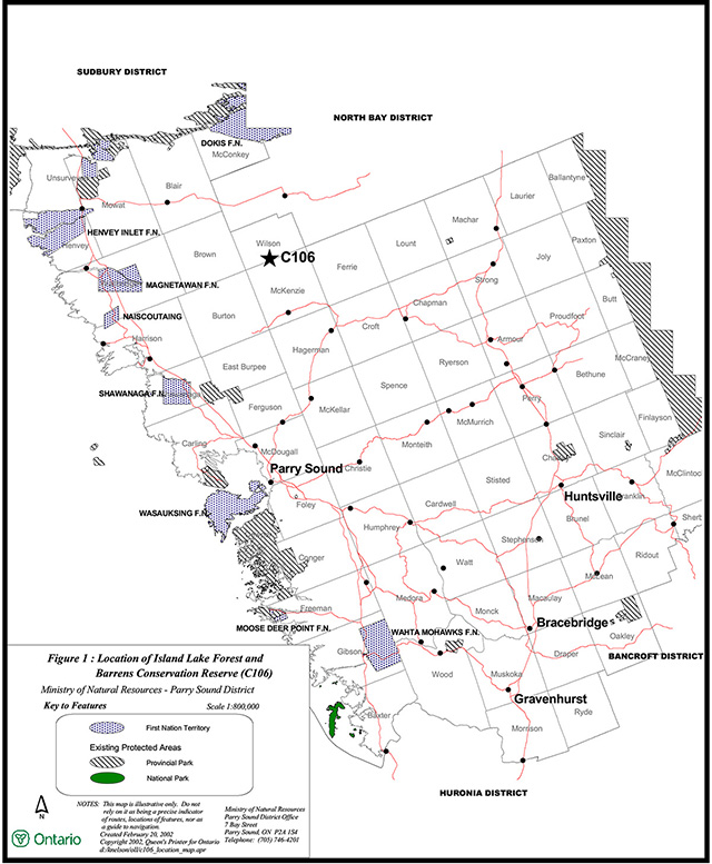
Enlarge figure 1 location map of Island Lake Forest and Barrens Conservation Reserve
Figure 2: Site Map - Island Lake Forest and Barrens Conservation Reserve (C106)
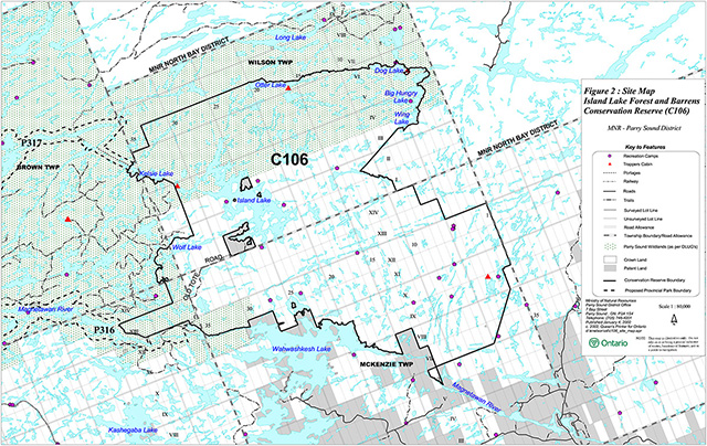
Enlarge figure 2 site map of Island Lake Forest and Barrens Conservation Reserve (C106)
Figure 3: Island lake Conservation Reserve and Surrounding Enhanced Management Areas
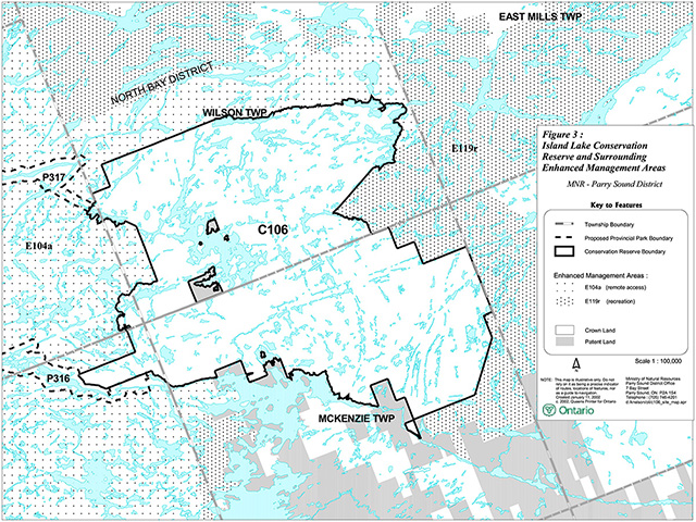
Enlarge figure 3 map of Island lake Conservation Reserve and Surrounding Enhanced Management Areas