Jollineau Conservation Reserve Management Statement
This document provides policy direction for the protection, development and management of the Jollineau Conservation Reserve and its resources.
Statement of Conservation Interest
Ministry of Natural Resources
Sault Ste. Marie District
Algoma Area
February 2004
Ce document est seulement disponsible en anglais.
Approval statement
I am pleased to approve this Statement of Conservation Interest (SCI) for Jollineau Conservation Reserve (C245).
Jollineau Conservation Reserve was established to protect white cedar and yellow birch dominated forests growing on till uplands. Balsam fir, sugar maple, white pine, and white birch are additional dominant forest cover types within the site. Some of the site’s white pine, sugar maple and yellow birch stands have been recorded at well over 100 years of age. Regulated on December 21, 2000, this 773 hectare conservation reserve is situated approximately 40 kilometres east of the community of Searchmont, in Jollineau and Hurlburt Townships.
Direction for establishing, planning and managing conservation reserves is defined under the Public Lands Act, the Ontario’s Living Legacy Land Use Strategy, and other applicable policies. The specific direction for managing this conservation reserve is in the form of a basic SCI, which defines the area to which the plan applies, provides the purpose for which the conservation reserve has been proposed, and outlines the Ministry of Natural Resources' management intent for the protected area. This SCI has been created with input from program specialists within Sault Ste. Marie District. It will provide both the foundation for continued monitoring of activities and guidance for managing the conservation reserve. More detailed direction at this time is not anticipated. However, should significant facility development be considered or complex issues arise requiring additional studies, more detailed management direction in the form of special protection measures, or a detailed Resource Management Plan, will be prepared with full public consultation.
Public and Aboriginal consultation occurred prior to the regulation of this conservation reserve. An additional 15-day consultation period took place in December, 2003 that provided stakeholders with an opportunity to comment on the draft SCI. Comments from the review period have been considered in the finalization of this document.
The management guidelines outlined in this SCI will be implemented by the Algoma Area Supervisor, and will be reviewed every five years and amended as required by the District Planner, Sault Ste. Marie District, Ministry of Natural Resources.
Written by:
Sheila Walsh,
OLL Planner
Date: January 26, 2004
Submitted by:
Erin Nixon,
District Planner
Date: February 5, 2004
Recommended For Approval by:
Ron Reffle
Algoma Area Supervisor
Date: February 24, 2004
Recommended For Approval by:
Serge Tenaglia R.P.F.
District Manager, Sault ste. Marie
Date: February 24, 2004
Approved by:
Rob Galloway
Regional Director, Northeast Region
Date: April 02, 2004
1.0 Introduction
The following document is a Statement of Conservation Interest (SCI) for Jollineau Conservation Reserve (C245). The purpose of this SCI is to identify and describe the natural, recreational, and cultural values of Jollineau Conservation Reserve and to outline the Ministry of Natural Resources' management intent for this area. The first three sections of this document highlight the provincial context in which it was produced, state its goal and objectives, and summarize the planning process for conservation reserves. Sections 4 through 7 are specific to Jollineau Conservation Reserve and provide background information and management direction for the site. Section 8 outlines the requirements for continued implementation and review of this document.
Management direction specified in this SCI will serve to protect the conservation reserve for the benefit of all Ontario residents. This direction will comply with the land use intent stated in the Ontario’s Living Legacy Land Use Strategy (LUS) (OMNR 1999) and associated policy clarification statements. Additionally, this conservation reserve will be managed under the Public Lands Act (OMNR 1997a), and will comply with all legal requirements as specified under the Environmental Assessment Act (R.S.O. 1990,Chapter E.18).
1.1 Provincial context
Ontario’s network of natural heritage areas has been established to protect and conserve areas representative of the diversity of the natural regions of the province, including the species, habitats, features, and ecological systems which comprise that natural diversity. Protected natural heritage areas are a key component in the sustainable management of natural resources. They ensure that representative sites within the larger managed landscape are retained in as natural a state as possible.
On July 16, 1999, the Ontario’s Living Legacy Land Use Strategy was released to guide the planning and management of much of Ontario’s Crown lands. Extensive consultation was conducted during the development of the LUS. The objectives of the LUS are to complete Ontario’s system of parks and protected areas; recognize the land use needs of the resource-based tourism industry; provide forestry, mining and other resource industries with greater certainty around land and resource use; and enhance hunting, angling and other Crown land recreational opportunities (OMNR 1999).
The LUS (OMNR 1999) contributes to Ontario’s system of protected natural heritage areas by designating 378 new areas to be protected. These areas are considered to be significant and require protection from incompatible activities in order for their values to endure over time. Jollineau Conservation Reserve now forms part of Ontario’s network of natural heritage areas. It protects white cedar (Thuja occidentalis L.) and yellow birch (Betula alleghaniensis Britton) dominated forests growing on till uplands. Balsam fir (Abies balsamea L.), sugar maple (Acer saccharum Marshall), white pine (Pinus strobus L.), and white birch (Betula papyrifera Marsh.) are additional dominant forest cover types represented within the conservation reserve. White spruce (Picea glauca (Moench) Voss), while not present as a dominant canopy species, is scattered throughout many of the stands.
The Ministry of Natural Resources has established conservation reserves as a tool to protect natural heritage areas on public lands, while permitting most traditional public land uses to continue. These uses include recreational activities, such as hunting and fishing, and the traditional activities of Aboriginal communities, as defined under applicable Aboriginal treaties. Lands designated as conservation reserves in the LUS (OMNR 1999) are removed from the Sustainable Forest License area, and mining and surface rights are withdrawn from staking under the Mining Act (RSO 1990 Chapter M.14).
The LUS (OMNR 1999) and subsequent policy clarification statements (OMNR 2000) outline the general land use policy and management direction for new conservation reserves. Each new conservation reserve will have a planning document, either a SCI or, in more complex situations, a Resource Management Plan, that details sitespecific management direction.
2.0 Goal and objectives of the SCI
2.1 Goal
The goal of this SCI is to provide the framework and the direction to guide management decisions affecting Jollineau Conservation Reserve.
2.2 Objectives
The following objectives are identified as the means to achieve the above stated goal:
- To describe the site’s current state of the resource in terms of its values and existing uses and activities
- To outline the Ministry of Natural Resources' management intent for the protected area
- To determine the land use compatibility of current land uses, and to develop specific guidelines and prescriptions to manage these uses
- To create public awareness of the values within this conservation reserve by providing information on the resources it contains and protects, and to support responsible stewardship through partnerships with local stakeholders
- To identify research, client services, and/or marketing strategies that may contribute to sound long-term management of the conservation reserve
- To identify the monitoring and/or research necessary to maintain the integrity of protected values
- To provide direction for the evaluation of proposed new uses or economic ventures through the application of the Test of Compatibility (Appendix C) and applicable Environmental Assessment Act legislation. This test will evaluate the impact of suggested use(s), either positive or negative, on the protected values of the conservation reserve.
3.0 Management planning
3.1 Planning for a Conservation Reserve
The planning process for a conservation reserve consists of regulating the site and preparing a site specific management plan. Consultation with the public, Aboriginal communities, and industry occur during site identification, boundary finalization, and management planning. Regulation of a conservation reserve involves preparing a legal description of site boundaries, removing the site from the Sustainable Forest License area, and withdrawing the site from staking under the Mining Act (RSO 1990 Chapter M.14). Once a conservation reserve is regulated, the level of management planning required to fulfill the protection targets is determined, and either a basic or enhanced SCI or a Resource Management Plan is prepared.
A basic SCI is prepared when there is no deviation from the land use direction provided in the LUS (OMNR 1999) and there are few to no issues that require resolution. Alternatively, a Resource Management Plan (RMP) is prepared in situations where one or more complex issues have to be addressed, or where there is widespread public interest in a site. An enhanced SCI is an intermediary document which is used when a site requires more detailed management direction than would be provided by a basic SCI, but does not have issues significant enough to warrant the preparation of a RMP. Whichever the determination, the plan must be completed within three years of the conservation reserve’s regulation date. The guidelines for the preparation of these documents are provided in Procedural Guidelines A - Resource Management Planning (Conservation Reserves Procedure PL3.03.05, Public Lands Act, OMNR 1997a) and the Northeastern Region Guidelines on the Planning Process for Conservation Reserves: Statement of Conservation Interest and Resource Management Plan (Thompson 2001).
A SCI is essentially a management plan, which receives its direction from the LUS (OMNR 1999). The purpose of a SCI is to identify the state of the resource in terms of the site’s values and its current land use activities, and to outline the Ministry of Natural Resources' management intent for the conservation reserve. Basic SCI is typically have a 15-day public consultation period, whereas enhanced SCI is and RMPs have a longer consultation period. Upon completion of this public review, the SCI, or RMP, is revised as necessary and approved by the appropriate Regional Director.
Existing permitted uses within conservation reserves may continue, unless they are shown to have a significant negative impact on the values protected by the site. A review/evaluation mechanism is in place to address proposed new permitted uses or land use proposals. The Test of Compatibility (Appendix C) as outlined in the Public Lands Act Policy PL 3.03.05 (OMNR 1997a), and/or other standard Ministry of Natural Resources' environmental screening processes, are used to screen future proposals. Where cultural resources may be impacted, proposals may be screened through Conserving a Future for our Past: Archaeology, Land Use Planning & Development in Ontario, Section 3 (Ministry of Culture 1998).
Public comment may be solicited during a review of any future land use proposals that require new decisions to be made. Appropriate Environmental Assessment Act (R.S.O. 1990, Chapter E.18) requirements and amendment processes will apply to any future proposal and/or any significant change in management direction being considered for a site.
3.2 Planning process for Jollineau Conservation Reserve
Jollineau Conservation Reserve was proposed as a conservation reserve in the LUS (OMNR 1999). Consultation has occurred with the public, Aboriginal communities, and industry, and the boundary of the site has been regulated through an amendment to Ontario Regulation 805/94 of the Public Lands Act on December 21, 2000, by Ontario Regulation 686/00. A copy of the public consultation materials from boundary regulation phase can be found in Appendix E.
To date, no significant issues related to land use in this conservation reserve have been identified. For this reason, it was determined that a basic SCI will adequately identify the site’s significant features and serve as the appropriate format for delivering the management guidelines. It should be noted that this document addresses only those issues or land use proposals currently known to the District Manager. The direction provided by this SCI, and future management decisions, will work to resolve any potential land use conflicts and to ensure that identified values continue to be adequately protected.
3.2.1 Planning area
The planning area for this SCI consists solely of the regulated boundary for Jollineau Conservation Reserve (Figure 1). However, to fully protect values within the conservation reserve, the area beyond the regulated boundary may require additional consideration when larger land use planning initiatives pose potential negative impacts on the conservation reserve. The forest management planning process is an example of when adjacent land management activities may consider sensitive features within the conservation reserve boundary.
4.0 Background information
4.1 Location and site description
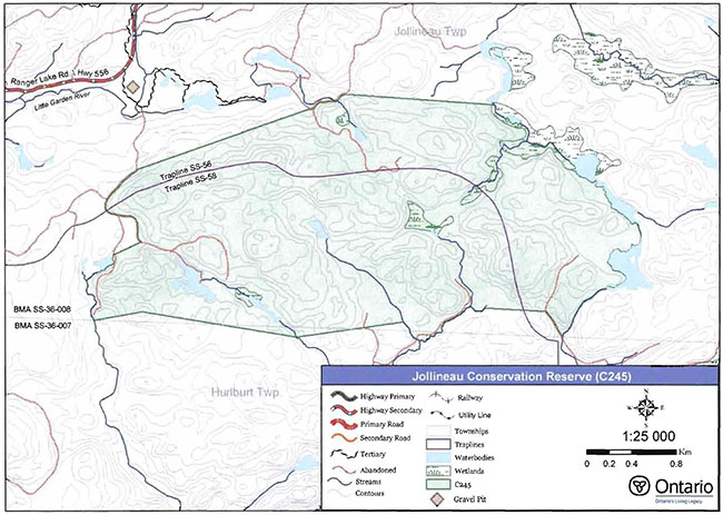
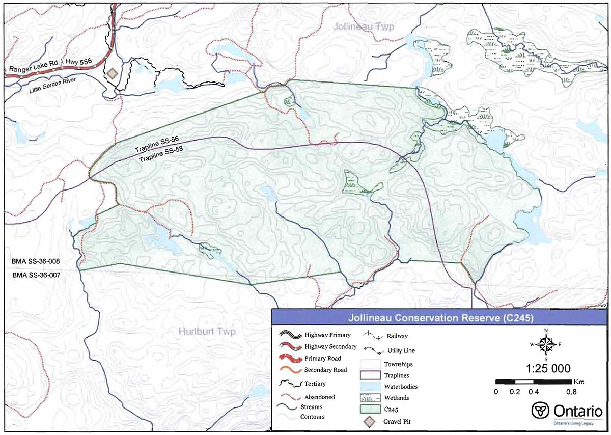
Jollineau Conservation Reserve is located approximately 40 kilometres east of the community of Searchmont. It lies mainly within Jollineau Township although a small portion of the site also falls within Hurlburt Township (see Figure 1). This site was regulated on December 21, 2000 and is 773 hectares in size. Table 1 summarizes the administrative details of the site.
Whenever possible, recognizable natural and cultural features, such as creeks, shorelines or old roads, have been used to delineate conservation reserve boundaries to facilitate on-the-ground identification. The eastern and western boundaries of Jollineau Conservation Reserve follow such natural features. The west boundary is defined mainly by an old trail, the shoreline of a small lake, and a creek system from that lake. The east boundary is defined by a system of lakes, creeks and wetlands. Parts of the north and south boundaries follow creeks or old trails, but the majority of these two boundaries are vectored (straight lines connecting two points) because there were few suitable natural or cultural features in these areas of the conservation reserve (see Map 1, Appendix A).
Table 1. Location and administrative details for Jollineau Conservation Reserve.
| Name | Jollineau Conservation Reserve (C245) |
|---|---|
| Site Region - Site District (Hills 1959) | 4E-3 Mississagi |
| Eco Region - Eco District (Crins and Uhlig 2000) | 4E-3 |
| OMNR Administrative Region/District/ Area | Northeast Region/Sault Ste. Marie District/ Algoma Area |
| UTM co-ordinates | 298279 E, 5187600 N (Zone 17 NAD83) |
| SCI Completed | January 26 2004 |
| Regulated | December 21 2000 |
| Area | 773 ha |
| Nearest Town | Approximately 40 km east of the community of Searchmont |
| Township(s) | Jollineau Hurlburt |
| OBM Numbers | 2017290051800,2017300051800 |
| Topographical Map Number I Name | 41 J/13 Ranger Lake |
| Wildlife Management Unit | 36 |
| Forest Management Unit | Algoma Forest |
Jollineau Conservation Reserve is readily accessible from Highway 556, also known as the Ranger Lake Road (Figure 1), although it is not possible to drive into the site in a full-size vehicle. The Ranger Lake Road passes just north of the conservation reserve, and a small road running south from there leads toward the conservation reserve. From this small road, a trail along an abandoned forest access road provides good access to the western side of the site. The trail continues into the west-central portion of the site, but its full extent has not yet been determined. Additional abandoned logging roads are shown on maps of the area, and access into the conservation reserve is believed to exist via these roads. For example, an old road forms a portion of the boundary midway along the north side of the conservation reserve. According to Ministry of Natural Resources' values maps, a branch of this old road leads to the central parts of the conservation reserve, but the actual current condition of the road has not been determined. Other old roads/trails approach the conservation reserve from the south, and may provide access to the southeast corner of the site. Other than the trail in the northwest corner of the site, the condition of all other possible access routes remains unconfirmed.
Jollineau Conservation Reserve is located within Hills' Site District 4E-3 (Hills 1959), an ecological unit extending roughly from Gogama and Chapleau in the north to Sudbury and Elliot Lake in the south. The conservation reserve is typical of conditions in the site district as it contains mixed hardwood and conifer dominated forests on rolling, rugged topography. Jollineau Conservation Reserve is reported to have moderate diversity based on the variety of forest communities and wetland conditions found within its boundaries (Nicholson et. al. 2003). In the mixedwood forests that populate this site, sugar maple, balsam fir, and white birch are the most common dominant species. Cedar and white pine dominated mixed forests are less common, found scattered mainly across the southern half of the conservation reserve. Cedar and white pine stand types were identified as desirable for protection (Crins 1996).
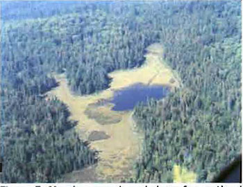
A few, small wetland communities are scattered across the conservation reserve. A more substantial wetland complex is situated on the northeast side of the site. These wetland features contribute to the site’s overall diversity, and provide moose feeding areas and habitat. Photos of the conservation reserve can be found in Appendix B.
Figure 1. Location of Jollineau Conservation Reserve (C245).
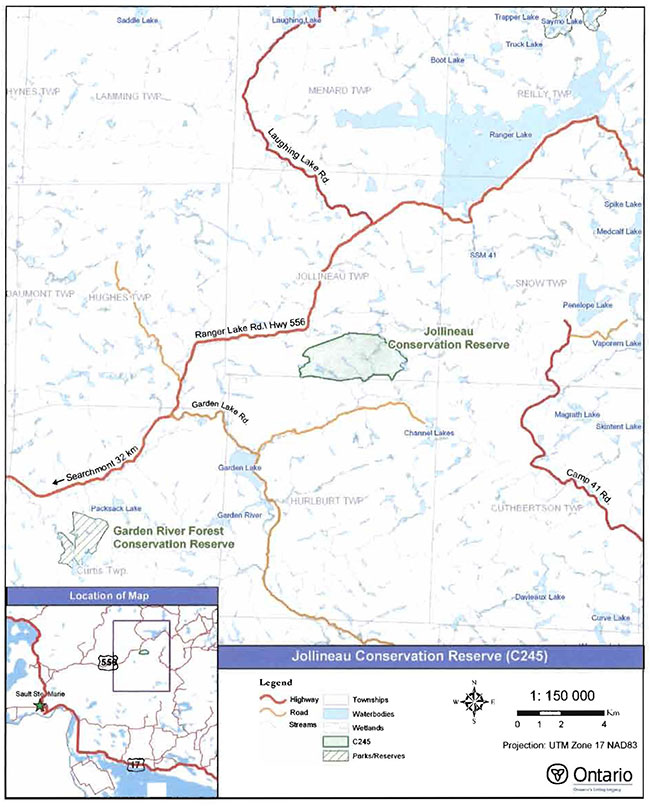
Enlarge Figure 1. Location of Jollineau Conservation Reserve (C245).
4.2 History of the site
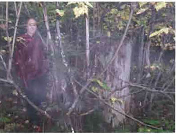
Logging has played an important role in the area around Jollineau Conservation Reserve. A review of historical aerial photos illustrates that logging took place in areas immediately surrounding this particular site location, as well as in areas that now lie within the regulated boundary. During the 1960s and 1970s, there was a progression of road construction and wood harvestin activities. Man of the smaller roads appear to have been constructed only as winter roads. Selective harvesting was most prevalent in the area during the early 1970s. In relation to the present conservation reserve boundary, past harvesting activities seem to have been focused primarily in the southern and eastern portions of the site. By 1980, many of the roads in the immediate area were no longer being used or maintained for harvest operations, and they were becoming grown over (Figure 2). At least some of these old roads have continued to be used as trails, providing access for pedestrian, all-terrain vehicle or snowmobile traffic. A gravel pit outside the northwest corner of the conservation reserve has been a source of gravel for maintenance of Ranger Lake Road.
Figure 2. Standing next to old yellow birch stump along west access trail.
(Photo by S. Walsh; September 2003)
4.3 Inventories
Table 2 indicates the current status of natural heritage inventories that have occurred in Jollineau Conservation Reserve. Recommendations for future inventory needs are located in Table 3, Section 7.2.
Table 2. Existing inventory and survey information for Jollineau Conservation Reserve.
| Type of Inventory | Inventory Method | Date(s) of Inventory | Report |
|---|---|---|---|
| Life Science | Aerial reconnaissance | 9 Sept. 2002 | Nicholson, J., L. King, and S. Longyear, 2003. Jollineau Conservation Reserve, Life Science Checksheet - Step2. Unpublished Information. Ontario Ministry of Natural Resources. (Draft) |
| Earth Science | Aerial reconnaissance | 9 Sept. 2002 | Kristjansson, F.J., 2003. Earth Science Inventory Checklist for Jollineau Conservation Reserve. Unpublished Information. Ontario Ministry of Natural Resources. (in prep.) |
| Recreation | Ground and aerial reconnaissance | Ground: 22 Sept. 2003 Aerial: 9 Sept. 2002 |
Latulippe, T. and M. Hall, 2003. Recreation Inventory Report- Jollineau Conservation Reserve (C245). Unpublished Information. Ontario Ministry of Natural Resources. |
5.0 State of the resource
5.1 Key values
Key values are those values that make this site unique and have led to its designation as a conservation reserve. Their protection is paramount. The key values found within Jollineau Conservation Reserve include the following:
- Scattered white spruce on shallow soils associated with steep bedrock slopes
- Upland stands of white cedar and yellow birch
- Old-growth white pine and sugar maple dominated forests
Additional values as listed in Section 5.2 through Section 5.6 are also important. Descriptions in this section are not necessarily complete. If new values, key or otherwise, are identified, they will be added to this section. If any new value is considered significant, management guidelines may be modified, if required, to ensure its protection.
5.2 Earth sciences values
Jollineau Conservation Reserve is located in a broad geologic area known as the Abitibi Uplands, which is characterized by an undulating, rocky landscape of uplands and valleys with an abundance of lakes, folds and faults. The Abitibi Uplands are largely underlain by gneissic and granitic rocks. This bedrock geology is covered generally by stony sandy tills with frequent flats and ridges of water-laid sand (Crins 1996).
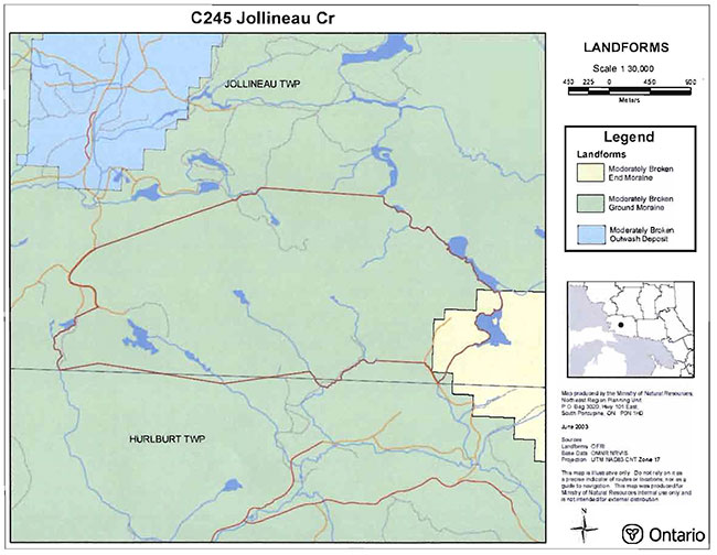
Within the conservation reserve, the topography is dominated by rolling rugged hills. According to provincial landform coverage (Nicholson et. al. 2003), almost the entire conservation reserve is classified as "moderately broken ground moraine". In the site’s extreme southeast corner, there is a small area classified as moderately broken end moraine (Nicholson et. al. 2003). Kristjansson (pers. comm.) however, suggests that a more accurate description of the site is bedrock-controlled, with till deposits overlying the bedrock.
Kristjansson (pers. comm.) describes the bedrock geology for the site as foliated to gneissic and granitic bedrock from the Abitibi subprovince of the Superior Province of the Precambrian Shield. Overlying the bedrock terrain are three depositional units: bedrock drift complex (Unit 2a-c); till deposits (Units 3 and 2a); and organic (Unit 9). The dominant condition in this conservation reserve is bedrock drift associated with the bedrock-controlled uplands. It is expected that moderate bedrock exposure will be encountered in this landscape (Kristjansson, pers. comm.). Till and organic deposits occur in the site’s lowland areas. Till deposits are moderately extensive while organic deposits are small and scattered. Overall, the earth science features captured within this conservation reserve are categorized as locally significant (Kristjansson, pers. comm.). Kristjansson (2003) describes in more detail the bedrock and surficial geology of the site in the Earth Science Inventory Checklist.
5.3 Life sciences values
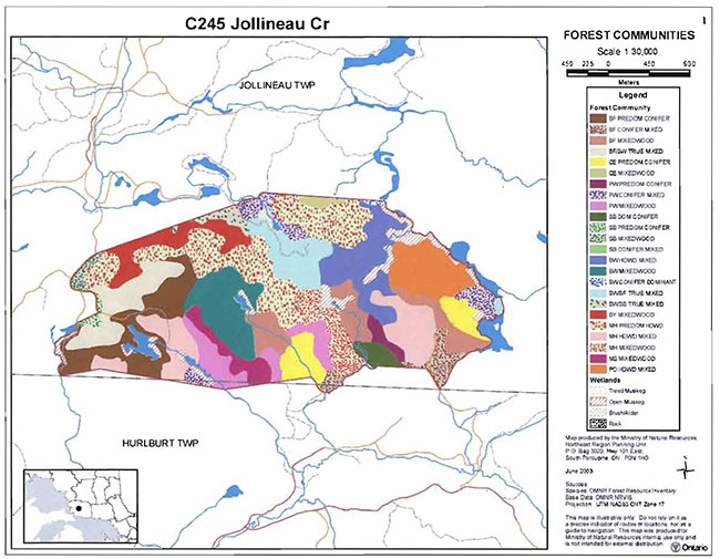
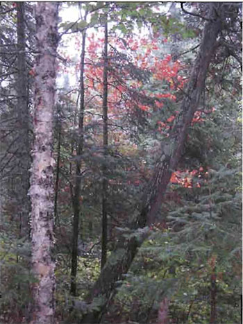
Jollineau Conservation Reserve supports a moderate diversity of forest communities. Forest stands within the site are typically mixed, with the most common dominant tree species being sugar maple, white birch and balsam fir. Less abundant within the conservation reserve, are other mixed stands dominated by white pine, cedar, poplar, black spruce, and red maple (Figures 3, 4) (see Map 3, Appendix 1). While capturing white spruce stands within this conservation reserve was identified as important (Crins 1996), white spruce does not actually constitute a dominant portion of any of the stands within the site (Nicholson et. al. 2003). White spruce does, however, exist as a canopy component in many of the site’s mixed stands.
Figure 3. White pine and white cedar in a mixed forest stand.
(Photo bv P.Burtch: November 1999)
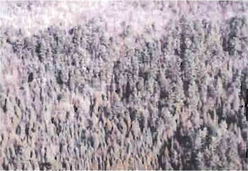
Figure 4. White birch, white pine, white cedar dominated mixed stands (left to right).
(Photo by P.Burtch; November 1999)
Stocking of the conservation reserve’s forest stands ranges from 40 to 100%, although most stands are in the range of 61 to 99% (Nicholson et. al. 2003). The northern half of the conservation reserve tends to have well-stocked stands, typically in the range of 80 to 90% stocked. Stands in the southern half of the conservation reserve have slightly lower stocking, mainly in the range of 60-80%, but as low as 40%. A white birch dominated mixedwood in the northeast, and a red maple dominated mixed stand in the southwest are reported to be fully stocked (100%) (Nicholson et. al. 2003).
The range of stand ages contributes to the site’s overall diversity. Most stands are in the range of 60-89 years, but a couple of stands have been recorded as 30-59 years, and others have been aged at more than 180 years. The oldest stand is a sugar maple dominated mixedwood of approximately 192 years. A couple of white pine dominated mixed stands are estimated to be 150-179 years. These stands have all been identified as possible old-growth stands (Nicholson et. al. 2003).
Individual wetlands within the conservation reserve are not abundant, although the site’s eastern boundary is defined by a creek that runs through a well-developed wetland complex. Nicholson et. al. (2003) described each of the wetland areas in the life science checksheet for Jollineau Conservation Reserve. The wetland complex on the site’s east boundary contains several fens, and a mixed marsh. In the southwest corner of the site, there are two distinct wetlands comprised of meadow marsh and shore fen conditions (Figure 5). Another small wetland in the middle of the conservation reserve has been identified as a fen. The wetland areas associated with the eastern boundary have been identified as moose aquatic areas (Nicholson et. at. 2003).
Figure 5. Meadow marsh and shore fen wetland complex in southwest corner of conservation reserve. The wetland is surrounded by balsam fir-dominated conifer mixed stands.
(Photo by B. Burkhardt; September 2002)
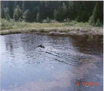
The conservation reserve has some important wildlife values. At minimum, it offers moose aquatic feeding areas associated with most of its wetlands. Confirmation that this site provides moose habitat was obtained during an inventory flight over the site in September 2002, when a large bull moose was observed swimming across one of the wetland areas within the site (Figure 6). Portions of two trapline areas lie within this conservation reserve, and it is expected that the series of creeks, lakes and wetlands provide ample habitat for small fur-bearing mammals.
Figure 6. Bull moose swimming across wetland pond.
(Photo by T. Latulippe; September 2002)
5.4 Recreational values
The main recreational activity known to take place in Jollineau Conservation Reserve is hunting. The site has the potential for a range of passive nature appreciation activities, including hiking, bird watching, and wildlife viewing. Several recreational features have been identified including: rolling to steep hills; a variety of mixed forest stand types and wetland features; at least one informal trail that is suitable for hiking to the interior of the site; and habitat for an abundance of bird and wildlife species. More detailed analysis of existing and potential recreational uses is available in the Recreation Inventory Report for Jollineau Conservation Reserve (Latulippe and Hall 2003).
Recreational activities tend to be dependent upon motor vehicle access to a site. The best access to Jollineau Conservation Reserve is from the northwest corner, off of Ranger Lake Road. A trail that follows the northwest boundary and then enters the conservation reserve midway down the west side is the most readily available access to the interior of the conservation reserve. This trail passes through a number of forest types and along wetland areas, thus providing the interested naturalist with viewing opportunities for different vegetation species and wildlife habitats.
5.5 Cultural values
This site falls within the Robinson-Huron Treaty area. To date, no First Nation community has identified any specific Aboriginal values within this conservation reserve.
5.6 Research values
There are no known research and/or monitoring activities occurring within this conservation reserve.
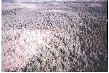
5.7 Site condition
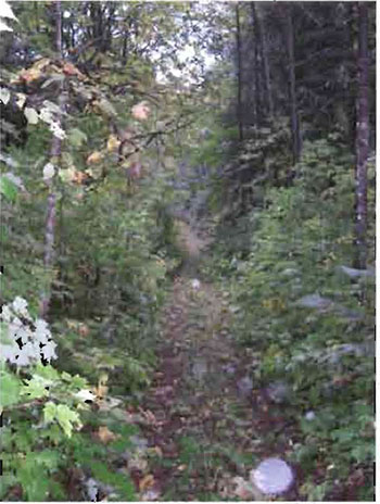
The area within the regulated boundary of this conservation reserve is described as having a low amount of disturbance. It is estimated that less than 10% of the site has been disturbed by human or natural activities in recent years (Nicholson et. al. 2003). Old logging roads along the boundary and extending into the site are identified as the main source of disturbance. The roads date back to the 1960s and 1970s when there was active harvesting in the area. According to historical air photo coverage of the area, harvesting within what are now the current conservation reserve boundaries appears to have been limited to areas in the southeastern portion of the conservation reserve, and was in the form of a selective cut.
At present, the poor condition of these old roads limits them to use only by small motorized vehicles (ATVs) or pedestrian traffic (Figure 7). The trail into the interior of the conservation reserve from the west boundary is subject to some erosion as it goes up a steep slope, and appears to act as a drainageway during heavy rains and spring runoff. Trail re-routing may be necessary during wetter times of the year.
Human disturbance, in the form of roads, private camps, gravel pits, and forest harvest operations, is evident beyond the regulated boundary of the site.
Figure 7. Trail on old road along west boundary of conservation reserve.
(Photo by s. Walsh; September 2003)
6.0 Management guidelines
All management guidelines in this SCI are based on direction contained in the LUS (OMNR 1999) and associated policy clarification statements (OMNR 2000). The management guidelines outlined in this section are specific to Jollineau Conservation Reserve and are intended to protect the site’s unique values. The guidelines in this document may be subject to change and may be amended as necessary. If a conflict between management guidelines exists, the conservation reserve will be managed to protect the integrity of its natural values, while permitting compatible land use activities (OMNR 1997a).
Proposed new uses and/or development, as well as research and education activities, will be reviewed on a case-by-case basis. Before new proposals can be permitted, the Test of Compatibility (Appendix C) must be passed as well as consideration of cultural values according to Conserving a Future for our Past: Archaeology, Land Use Planning & Development in Ontario, Section 3 (Ministry of Culture 1998). In addition, all new proposals are subject to applicable Environmental Assessment Act (R.S.O. 1990, Chapter E.18) requirements.
The following management strategies have been devised to achieve the goal and objectives of the SCI for Jollineau Conservation Reserve. A summary table of the management guidelines for this site can be found in Appendix D. For the most up-todate version of this summary table, please refer to the Crown Land Use Atlas,located on the Internet at /page/crown-land-use-policy-atlas, or contact your local Ministry of Natural Resources office. The Crown Land Use Atlas is a consolidation of existing local land use policies for Crown lands within the OLL planning area, an area that covers 45% of the province, extending from Lake Simcoe in the south to the Albany River in the north.
6.1 Industrial activities
6.1.1 Commercial timber harvest
The area contained within this conservation reserve (773 ha) has been withdrawn from the Algoma Sustainable Forest License area and no commercial timber harvesting will be permitted. Please refer to Section 6.4.3 for information regarding non-commercial wood harvesting.
6.1. 2 Mining and exploration
There are no existing mining claims or leases within this conservation reserve. Mining and surface rights have been withdrawn from staking under the Mining Act (RSO 1990 Chapter M.14). Mineral exploration is not permitted.
6.1.3 Extraction of peat, soil, aggregate and other material
Extraction of peat, soil, aggregate and other material is not permitted.
6.1.4 Energy generation
Hydropower development and windpower generation are not permitted.
6.2 Existing and proposed development
6.2.1 Transportation corridors
6.2.1.1 Roads
According to the LUS (OMNR 1999), new roads for resource extraction will not be permitted except for those identified in Forest Management Plans prior to March 31, 1999. No new or existing roads for resource extraction were identified.
6.2.1.2 Trails
Currently, an informal trail has been identified following along the old forest access road network on the west side of the conservation reserve. Recreational use of this existing trail can continue, though the impact of motorized vehicular use of this trail will be monitored and if necessary, an alternate management direction for this site may be developed.
Any proposed new trails will be subject to the Test of Compatibility (Appendix C) and applicable Ministry of Natural Resources policies and procedures. Trail development in low-lying areas and wetlands will be discouraged, as will trail development over shallow soils on rock outcrops. All new and existing trail heads and trail routes must be recorded using new technologies (i.e. global positioning systems) to ensure an accurate record of the location of the feature. This location information must be provided to the Sault Ste. Marie District, Ministry of Natural Resources.
6.2.2 Other corridor development/maintenance
No communication, energy transmission, or other non-road corridors are located within this conservation reserve. New corridor developments will be actively discouraged. Proposals for new corridors will be subject to the Test of Compatibility (Appendix C) and applicable Ministry of Natural Resources policies and procedures.
6.2.3 Natural heritage appreciation facilities/recreational structures
There are currently no existing authorized natural heritage appreciation facilities or recreational structures (i.e. boardwalks, bird viewing platforms, kiosks, ski shelters, or interpretative signs). New natural heritage appreciation facilities and recreation structures are permitted, subject to the Test of Compatibility (Appendix C) and applicable Ministry of Natural Resources policies and procedures.
6.2.4 Land disposition
Sale of Crown lands is not permitted, except for those situations described in the policy clarification tables (OMNR 2000).
Presently, no Land Use Permits (LUPs) have been issued within this conservation reserve for private or commercial recreational facilities. New leases or LUPs may be issued for approved public uses (i.e. not for private recreation camps), subject to the Test of Compatibility (Appendix C) and applicable Ministry of Natural Resources policies and procedures. These leases/permits will not be sold but may be eligible for enhanced tenure or transfer.
Enhanced tenure is defined as anything beyond the term and form of current tenure. All requests for transfer or enhanced tenure will be subject to the following screening criteria:
- Is the transfer or enhanced tenure consistent with the conservation reserve’s land use intent, which is the protection and enhancement of the site’s natural, recreational and cultural values?
- Is it consistent with the land disposition policies outlined in the District Land Use Guidelines, the Crown Land Use Atlas, this SCI and any other applicable document?
- Does it adversely affect the values as identified in Section 5.0, and/or conflict with other uses?
- Is land needed by the Crown to protect significant natural or recreational values outlined in this SCI?
- Does the transfer or enhanced tenure clash with traditional Aboriginal uses, land claims or agreements?
- Are all rents, taxes, fees, rates or charges paid up for the existing LUP or lease?
6.3 Commercial activities
6.3.1 Commercial bait harvesting
Jollineau Township is currently allocated to one commercial bait harvesting operation. New operations can be considered subject to the Test of Compatibility (Appendix C) and applicable Ministry of Natural Resources policies and procedures.
Under Public Lands Act PL 3.03.08 "Buildings for Bait Harvesting Management" (OMNR 2002), cabins for the purposes of bait harvesting may be constructed on Crown land. However, such buildings should be avoided within this conservation reserve wherever possible and be established on Crown land outside of the protected area.
6.3.2 Commercial fishing
There are currently no commercial fisheries. New operations may be considered subject to the Test of Compatibility (Appendix C) and applicable Ministry of Natural Resources policies and procedures.
6.3.3 Commercial fur trapping
The north half of Jollineau Conservation Reserve lies within Registered Trapline Area SS56, while the south half lies within Registered Trapline Area SS58. Both areas are currently allocated to head trappers. If a head trapper surrenders a registered trapline, or the head trapper’s privileges are revoked, the registered trapline may be transferred to another trapper following established allocation procedures. If the registered trapline is not transferred in due course, or remains unallocated for a significant period of time, reallocation of the trapline may occur following applicable district screening processes.
The establishment of new trapline trails will be considered following the procedure and criteria for new trails as outlined in Section 6.2.1.2. No trap cabins currently exist within Jollineau Conservation Reserve. The establishment of new trap cabins will not be permitted.
6.3.4 Bear Management Areas
The majority of the conservation reserve is situated within Bear Management Area (BMA) SS-36-008. The small portion of the conservation reserve that is in Hurlburt Township is in registered BMA SS-36-007. Guided hunting activities associated with a BMA may continue. Transfers of BMAs may be permitted in cases where the current operator sells their bear hunting business to another operator and the BMA transfer is approved. If an operator surrenders the BMA or the BMA is revoked, reallocation of the BMA may occur following applicable district screening processes.
6.3.5 Commercial food collection
There are currently no existing commercial food harvesting ventures. Any new ventures requiring permits from the Ministry of Natural Resources will be subject to the Test of Compatibility (Appendix C) and applicable Ministry of Natural Resources policies and procedures.
6.3.6 Commercial non-timber forest products
Commercial harvesting of non-timber forest products is not consistent wit the intent of the conservation reserve and will not be approved.
6.3.7 Outpost camps/main base lodges
There are currently no existing authorized outpost camps or main base lodges in the conservation reserve. New outpost camps and main base lodges may be considered and will be subject to the Test of Compatibility (Appendix C) and applicable Ministry of Natural Resources policies and procedures. The form of land tenure for these new uses will remain as a land use permit or a lease. Sale of Crown land for new outpost camps or mainbase lodges will not be permitted.
6.4 Non-commercial activities
6.4.1 Nature appreciation/recreation activities
Off-trail hiking, cross-country skiing, snowshoeing, and other non-motorized activities will be permitted within this conservation reserve. However, should the impact of these activities degrade the landscape, the Ministry of Natural Resources will re-evaluate these permitted uses and decide upon a new strategy for this site. New trails to support these activities may be considered. Please refer to Section 6.2.1.2 for more details related to trail development.
6.4.2 Camping
There are no maintained campsites or campgrounds within this conservation reserve. Crown land camping policies apply, unless significant adverse effects on protected values necessitate further planning and management for this activity. Existing campsites should be used where they exist and campers should avoid sensitive areas.
6.4.3 Non-commercial consumptive resource use
Cutting of trees for non-commercial purposes may be authorized via a permit issued by the local Ministry of Natural Resources office, subject to review and determination of the impact that such cutting would have on the values identified in Section 5.0. Such permits are intended only for leaseholders, Land Use Permit holders within the conservation reserve who do not have road access to their property and have no alternate wood source outside of the conservation reserve. This permit is intended to cover fuelwood, dock stringers, and other occasional small scale uses.
Non-commercial harvesting of non-timber forest products such as berries, mushrooms, sphagnum moss (Sphagnum spp.), and wild rice (Zizania sp.) can occur provided the values of the site, identified in Section 5.0, are not jeopardized.
6.4.4 Hunting and fishing
Hunting is a traditional activity within this conservation reserve. In conjunction with current hunting regulations and conservation reserve policy, hunting is permitted to continue. Recreational fishing is also permitted to continue in compliance with current fishing regulations.
6.4.5 ATV and snowmobile use
No authorized snowmobile trails have been identified. Please refer to Section 6.2.1.2 for more information on trails. In general, off-trail use of ATVs and snowmobiles is not permitted. However, off-trail use is permitted for licensed trappers to access their traplines and for licensed bait harvest operators to conduct bait harvest operations. Off-trail ATV and snowmobile use are also permitted for the direct retrieval of large game by hunters. In all these cases, off-trail use is only permitted provided the protection of the site’s values is not compromised. Should the impact of off-trail ATV and snowmobile use degrade the landscape, the Ministry of Natural Resources will re-evaluate these permitted uses and determine a new strategy.
6.5 Resource management activities
Resource management activities refer to those tools used to protect and enhance the values of this conservation reserve. Some management activities may require the use of intrusive techniques. Under normal circumstances, some of these techniques would not be permitted to occur in the conservation reserve; however, if they are found to be necessary, they may be applied under controlled conditions, to achieve a desired result. Infrastructure such as roads, trails and buildings may need to be constructed to support activities such as prescribed burns, forest regeneration, wildfire control, and insect and disease control. Activities described in this section will be deemed acceptable if the ultimate outcome is in compliance with the management intent for this conservation reserve.
6.5.1 Insect and disease control
This conservation reserve will be maintained in as natural a state as possible. Insect and disease control measures should only be considered if the identified values are significantly threatened.
6.5.2 Fire management
The Ministry of Natural Resources recognizes fire as an essential process fundamental to the ecological integrity of conservation reserves. In accordance with existing conservation reserve policy and the Forest Fire Management Strategy for Ontario, forest fire protection will be carried out as on surrounding lands.
Whenever feasible, the Ministry of Natural Resources' fire program will endeavor to use "light on the land" techniques, which do not unduly disturb the landscape, in this conservation reserve. Examples of light on the land techniques may include limiting the use of heavy equipment or limiting the number of trees felled during the fire response efforts.
Opportunities for prescribed burning to achieve ecological or resource management objectives may be considered. These management objectives will be developed with public consultation prior to any prescribed burning, and will be reflected in the document that provides fire management direction for this conservation reserve. Plans for any prescribed burning will be developed in accordance with the Ministry of Natural Resources Prescribed Burn Planning Manual (OMNR 1997b) and the Environmental Assessment Act (R.S.O. 1990, Chapter E.18).
6.5.3 Fish and wildlife management
New fish and wildlife management activities may be considered but will require the approval of a separate fish/wildlife management plan, which must be referenced in this SCI and/or an amendment to this SCI to include specific management prescriptions. New fish and wildlife management activities are also subject to the Test of Compatibly (Appendix C) and applicable Ministry of Natural Resources policies and procedures.
6.5.4 Vegetation management
New vegetation management activities may be considered but will require the approval of a separate vegetation management plan, which must be referenced in this SCI and/or an amendment to this SCI to include specific management prescriptions. New vegetation management activities are also subject to the Test of Compatibly (Appendix C) and applicable Ministry of Natural Resources policies and procedures.
6.5.5 Forest renewal
Preference will be given to natural regeneration following any disturbance in the conservation reserve. In some cases, regeneration may be artificially assisted when it is deemed appropriate to mitigate against human disturbances (e.g. illegal occupation and trespass).
6.6 Research
Scientific research is encouraged, by qualified individuals or institutions, that contributes to a better understanding of the natural and cultural values protected by this conservation reserve, or that advances the protection, planning and management of these values. The Sault Ste. Marie District Planner should be contacted for information on research and/or monitoring opportunities within this conservation reserve. Proposals to conduct research should be directed to the Algoma Area Supervisor, Ministry of Natural Resources, Sault Ste. Marie District Office, and will be subject to the Test of Compatibility (Appendix C) and applicable Ministry of Natural Resources policies and procedures. Any site that is disturbed during research activities is to be rehabilitated as closely as possible to its original condition. Collecting may only be permitted as part of an authorized research project and may be subject to appropriate permits and conditions.
Existing Forest Resource Inventory surveys and approved resource monitoring activities are permitted to continue.
6.7 Marketing
No active marketing of this conservation reserve is anticipated.
6.8 First nations
Traditional activities and Aboriginal rights, as defined in the Robinson-Huron Treaty and other applicable legislation, will not be affected within or by the boundaries of this conservation reserve.
Any First Nation land claims within this area will be addressed according to appropriate Ministry of Natural Resources procedures. When possible, the Ministry of Natural Resources will work with the Ontario Ministry of Culture to identify archaeological sites to be protected.
7.0 Recommendations
7.1 Additions to the reserve
Jollineau Conservation Reserve protects representative stands of cedar and yellow birch on the landform known as Ia-6 [strongly broken deep and shallow sandy till uplands (bare bedrock)] (Crins 1996). The conservation reserve also captures stands having a scattered white spruce component, and as such, ensures the protection of the site district’s best representation of white spruce on this landform (Crins 1996). Wetlands along the eastern boundary are only partly protected as the boundary follows a creek that runs through the Centre of the wetland. To capture the entire wetland feature, the boundary would need to be shifted eastward. The regulated boundary effectively protects only the core values of this site. Boundary adjustments that would improve the protection of these values should be considered.
The site’s current vectored boundaries are in some cases artificially truncating natural features (forest stands) and thus interfering with their full protection. Wherever possible, the vectored boundaries of this site should be modified to follow natural or cultural features (streams, roads, etc.), without compromising the core values already being protected.
7.2 Future needs and considerations
The values protected by the Jollineau Conservation Reserve should be considered in land use management activities on adjacent properties to ensure sufficient protection of the site’s core values.
Table 3 highlights future needs and considerations for Jollineau Conservation Reserve.
7.3 Monitoring
Periodic monitoring of human activities and/or their impacts within this conservation reserve will be conducted. A schedule for cursory field monitoring will be identified within the District’s annual compliance plan and an IFM (Integrated Field Monitoring) inspection report will be filed at the Sault Ste. Marie District Office. The Algoma Area Supervisor will oversee these activities. In addition, Conservation Officers will complete periodic compliance monitoring to ensure the protection mandate is maintained. If at any time human activities are deemed to be negatively impacting the protected features, the activities will be reviewed and measures taken to mitigate any disturbance.
Approved inventory, monitoring, assessment, or research activities that are compatible with protection objectives are encouraged. Any area that is disturbed during research activities is to be rehabilitated as closely as possible to its original condition. The Algoma Area Supervisor may apply additional conditions.
Table 3. Future needs and considerations for Jollineau Conservation Reserve.
| Future Needs/Considerations | Details |
|---|---|
| Detailed Life Science Inventory | The Northeast Region should complete the final stage of the life science inventory. Completion of the final stage of life science inventory includes an assessment of the site’s significance and its contribution to the parks and protected areas program. |
| Boundary Marking | Vectored boundaries should be clearly marked for long term recognition, so that the site’s values are protected from surroundi land use acivities. |
| Trail Inventory | Determine location, extent and condition of all trails that provide access to the conservation reserve; ensure all trail heads and routes are recorded using GPS. |
| Partnership Development | Efforts should be made to work with partners (such as the Ontario Forest Research Institute (OFRI), Sault College of Applied Arts and Technology) to gather baseline data on this site to assist with future monitori and ins on activities. |
| Education | Educate public who use Crown land features in/around this conservation reserve about the site’s natural heritage; protection intent of the CR; permitted uses; etc. |
| Funding | Efforts should be made to obtain funding to support the above listed items, including monitoring, assessment, and inspection requirements for this site. |
8.0 Implementation, review and revisions
8.1 Responsibility
The Sault Ste. Marie District will be responsible for implementing the management policies and guidelines for Jollineau Conservation Reserve. The primary role will be to provide public information and compliance monitoring to ensure adherence to current policies and guidelines.
8.2 Review and revisions
The Jollineau Conservation Reserve SCI will be reviewed every five years by the District Planner to confirm and update the information in this document. Revisions to this document will be subject to requirements as specified in the Environmental Assessment Act (R.S.O. 1990, Chapter E.18). If changes in management direction are needed at any time, the significance of the changes will be evaluated. Minor amendments to the plan that do not alter the overall protection objectives may be considered and approved by the Area Supervisor without further public consultation. All minor amendments to the SCI will be documented in Appendix F. In assessing major amendments, the need for a more detailed Resource Management Plan (RMP) will first be considered. Where a RMP is not considered necessary or feasible, a major amendment to management direction may be considered with public consultation. Major amendments will be recommended by the District Manager and approved by the Regional Director, and will follow the appropriate guidelines (OMNR 2001).
Literature cited
Crins, W.J. 1996. Life Science Gap Analysis for Site District 4E-3. Unpublished information. Ontario Ministry of Natural Resources.
Crins, W.J. and P.W.C. Uhlig, 2000. Ecoregions of Ontario: Modification to Angus Hills' Site Regions and Site Districts - Revisions and Rationale.
Hills, G.A. 1959. A Ready Reference for the Description of the Land of Ontario and its Productivity. Preliminary Report. Ontario Department of Lands and Forests. Maple. Ontario.
Kristjansson, F.J. (in prep). Draft Earth Science Inventory Checklist for Jollineau Conservation Reserve (C245). Unpublished information. Ontario Ministry of Natural Resources.
Latulippe, T. and M. Hall. 2003. Recreation Inventory Report for Jollineau Conservation Reserve (C245). Unpublished information. Ontario Ministry of Natural Resources.
Ministry of Culture. 1998. Conserving a Future for Our Past: Archeology Land Use Planning and Development in Ontario. Ministry of Culture, Heritage and Libraries Branch - Heritage Operations Unit.
Nicholson, J., L. King and S. Longyear, 2003. Jollineau Conservation Reserve (C245), Life Science Checksheet - Step 2. Unpublished information. Ontario Ministry of Natural Resources.
Ontario Ministry of Natural Resources, 1997a. Conservation Reserves. Lands and Waters Branch Policy. Public Lands Act, PL 3.03.05. Date Issued: February 11, 1997.
Ontario Ministry of Natural Resources, 1997b. Prescribed Burn Planning Manual. AFFMB Publication No. 313. Ontario Ministry of Natural Resources.
Ontario Ministry of Natural Resources. 1999. Ontario’s Living Legacy Land Use Strategy. Queen’s Printer for Ontario: Ontario, Canada.
Ontario Ministry Natural Resources. 2000. Policy Clarification for Conservation Reserves. Unpublished document. September 2000.
Ontario Ministry Natural Resources, 2001. Procedures for the Amendment of Ministry of Natural Resources Land Use Direction. Ontario Ministry of Natural Resources.
Ontario Ministry of Natural Resources, 2002. Buildings for Bait Harvesting Management. Public Lands Act, PL 3.03.08.
R.S.O. 1990, Chapter E.18. Environmental Assessment Act. [Accessed: September 15, 2003] http://www.e-laws.gov.on.ca/DBLaws/Statutes/English/90e18_e.htm.
R.S.O. 1990, Chapter M.14. Mining Act. [Accessed: September 15, 2003] http://www.elaws.gov.on.ca/DBLaws/Statutes/English/90m14_e.htm.
Thompson, J. 2001. Northeast Region Guidelines on the Planning Process for Conservation Reserves: Statements of Conservation Interest and Resource Management Plan. Unpublished information. Ontario Ministry of Natural Resources.
Appendix A: Jollineau Conservation Reserve maps
Map 1. Recreational and other values in Jollineau Conservation Reserve.
Enlarge Map 1. Recreational and other values in Jollineau Conservation Reserve.
Map 2. Landforms in Jollineau Conservation Reserve, according to provincial landform coverage.
(Source: Life Science Checksheet (Nicholson et. al. 2003))
Map 3. Forest communities in Jollineau Conservation Reserve.
(Source: Life Science Checksheet (Nicholoson et. al. 2003))
Enlarge Map 3. Forest communities in Jollineau Conservation Reserve.
Appendix B: Jollineau Conservation Reserve photos
Photo 1. NE portion of conservation reserve looking westward. Wetland complex includes poor fen, moderately rich fen, mixed marsh and shore fen. Forest communities consist of white birch, sugar maple mixed stands (top of photo) and trembling aspen mixed stand (left of photo).
(Photo by B. Burkhardt; September 2002)
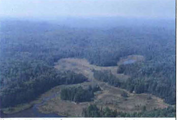
Photo 2. Trembling aspen dominated stand on eastern side of conservation reserve.
(Photo by P. Burtch; November 1999)
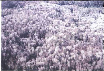
Photo 3. Stunted larch trees in wetland.
(Photo by S. Walsh; September 2003)
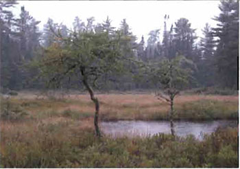
Photo 4. Fallen tree cleared from trail on west side of conservation reserve.
(Photo by S. Walsh; September 2003)
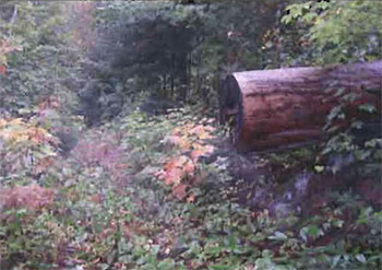
Photo 5. Understory of mixed conifer stand, with shite spruce tree in upper left.
(Photo by S. Walsh; September 2003)
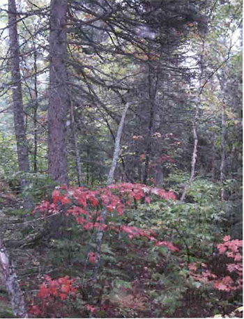
Photo 6. White birch and cedar in a mixed conifer stand.
(Photo by S. Walsh; September 2003)
Appendix C: Test of Compatibility
Test of Compatibility
The Conservation Reserve policy provides broad direction with regard to the permitted uses. The policy provides only an indication of the variety of uses that will be considered acceptable in conservation reserves. Any new uses, and commercial activities associated with them, will be considered on a case by case basis, and, subject to the following test of compatibility. To ensure a standard screening process is followed, reviews of all current and new activities will be subject to the screening criteria as specified by the Environmental Assessment Act (R.S.O. 1900, Chapter E.18).
The following outlines the two steps involved in performing a Test of Compatibility. An assessment of current activities would only follow step two, which focuses on the impacts. An assessment of any new activity would consider the impact of the activity and its conformity to the SCI/RMP.
-
Conformity to SCI/RMP: SCI describe values for which an area has been set aside and the range of appropriate uses that will be permitted in the area. SCI may also speak to the acceptability of other 'new' uses currently not occurring in the area.
The first 'test' is: "do proposed new land uses and/or commercial activities conform to the direction of the SCI/RMP for the conservation reserve? Would the new use(s) depart from the spirit of appropriate indicator land uses in the SCI/RMP?"
- Impact Assessment: If the proposed use(s) pass test 1 it is important to determine their impact on the area before they are approved. This should include the following:
- Impact on natural heritage values: "will the new use(s) impact any natural values in the area? If so how and to what degree? Is it tolerable?"
- Impact on cultural values: "will the new use(s) impact an historical or archaeological values in the area?"
- Impact on research activities: "will the new use(s) affect research activities in the area?"
- Impact on current uses: "will the new use(s) have any negative impact on the array of current uses?"
- Impact on area administration: "will the new use(s) increase administrative costs and/or complexity?" (For example, the cost of area monitoring, security and enforcement).
- Impact on accommodating the use outside the conservation reserve: "Could the use(s) be accommodated as well or better outside the conservation reserve?"
- Impact on socio-economics of the area: "will the new use(s) affect the community(ies) surrounding the area in a positive or negative way?" (For example, will the new use make an area less remote thereby affecting a local tourism industry that is dependent on the area’s remoteness for its appeal?"
- Impact on area accessibility: "does the new use(s) give someone exclusive rights to the area or a portion of the area to the exclusion of other existing uses?"
Appendix D: Summary of permitted uses
The following Policy Report was obtained from the Crown Land Use Atlas website during completion of this SCI (fall 2003). Changes may have been made to this policy report since that time. For the most recent version of this policy report, please refer to the Crown Land Use Atlas on the Internet at /page/crown-land-use-policy-atlas or contact your local Ministry of Natural Resources office.
For the most recent version of this policy report, please refer to the Crown Land Use Atlas located on the internet at /page/crown-land-use-policy-atlas or contact your local Ministry of Natural Resources office.
Crown Land Use Atlas - Policy Report
Identification:
ID: C245
Area Name: Jollineau
Area (ha): 773
Designation: Conservation Reserve (Ontario’s Living Legacy)
District(s): Sault Ste. Marie
Description:
The hilly and rugged uplands of the Jollineau Forest include stands of white cedar, white spruce and yellow birch and some old growth white pine-and sugar maple dominated forests. The yellow birch stands are at least 120 years old and include patches that are more than 190 years old. The landform - steep hills of shallow soils, with pockets of bedrock and deep soils -supports scattered white spruce forest, an uncommon combination of vegetation and landforms in Site District 4E-3.
Jollineau was regulated as a conservation reserve on December 21, 2000.
Land use intent:
Management of this area is also governed by the general policies contained in the Land Use Strategy (1999).
Management direction:
Those uses and management activities not listed in the following table are governed by existing conservation reserve policy. Over time the management direction will be elaborated in a Statement of Conservation Interest or Resource Management Plan. Any new uses, and commercial activities associated with conservation reserves, will be considered on a case by case basis, and they must pass a test of compatibility to be acceptable. Compatibility is normally determined through a planning process.
Commercial activities
| Activity | Permitted | Guidelines |
|---|---|---|
| Aggregate Extraction: | No | |
| Bait Fishing Existing: | Yes | Existing use permitted to continue, unless there are significant demonstrated conflicts. |
| Bait Fishing New: | Maybe | New operations can be considered, subject to the "test of compatibility" |
| Commercial Fishing Existing: | Yes | Existing use permitted to continue, unless there are significant demonstrated conflicts. |
| Commercial Fishing New: | Maybe | New operations can be considered, subject to the "test of compatibility". |
| Commercial Fur Harvesting Existing: | Yes | Existing use permitted to continue, unless there are significant demonstrated conflicts. Existing trap cabins can continue; new cabins are not permitted. |
| Commercial Fur Harvesting New: | Maybe | New operations can be considered, subject to the "test of compatibility". |
| Commercial Hydro Development: | No | |
| Commercial Timber Harvest: | No | |
| Commercial Tourism Existing: | Yes | Existing authorized facilities can continue, unless there are significant demonstrated conflicts. |
| Commercial Tourism New: | Maybe | New tourism facilities can be considered during the planning for an individual reserve. |
| Bear Hunting by Non residents (guided) Existing: | Yes | Existing authorized operations permitted to continue. |
| Bear Hunting by Non residents (guided) New: | No | New operations not permitted. |
| Outfitting Services Existing: | Yes | Existing authorized operations permitted to continue. |
| Outfitting Services New: | Maybe | New operations can be considered during the planning for an individual reserve. |
| Outpost Camps Existing: | Yes | Existing authorized facilities permitted to continue. |
| Outpost Camps New: | Maybe | New facilities can be considered during the planning for an individual reserve. |
| Resorts/lodges Existing: | Yes | Existing authorized facilities permitted to continue. |
| Resorts/lodges New: | Maybe | New facilities can be considered during the planning for an individual reserve. |
| Boat Caches (Managed): | ||
| Energy Transmission and Communications Corridors Existing: | Yes | These facilities should avoid conservation reserve lands wherever possible. |
| Energy Transmission and Communications Corridors New: | No | |
| Food Harvesting (Commercial) Existing: | Maybe | |
| Food Harvesting (Commercial) New: | Maybe | |
| Mineral Exploration and Development: | No | |
| Peat Extraction: | No | |
| Wild Rice Harvesting Existing: | Yes | |
| Wild Rice Harvesting New: | Maybe |
Land and resource management activities
| Activity | Permitted | Guidelines |
|---|---|---|
| Crown Land Disposition Private Use: | Maybe | |
| Crown Land Disposition Commercial Use: | Maybe | Sale of lands is not permitted, except for minor dispositions in support of existing uses (e.g. reconstruction of a septic system). Renewals of existing leases and land use permits are permitted. Requests for transfer of tenure will be considered in the context of the Statement of Conservation Interest or Resource Management Plan. New leases or land use permits permitted for approved activities. Tourism facilities can apply to upgrade tenure from LUP to lease. |
| Fire Suppression: | Yes | Fire suppression policies are similar to adjacent Crown lands, unless alternative fire policies have been developed through a planning process. |
| Fish Habitat Management: | Maybe | |
| Fish Stocking: | Maybe | Existing authorized operations permitted to continue. New operations not permitted. |
| Inventory/disease Supperssion: | Maybe | |
| Inventory/Monitoring: | Maybe | |
| Prescribed Burning: | Maybe | |
| Roads (Resource Access) Existing: | Yes | |
| Roads (Resource Access) New: | Maybe | Existing roads can continue to be used. Continued use will include maintenance and may include future upgrading. New roads for resource extraction will not be permitted, with the exception of necessary access to existing forest reserves for mineral exploration and development. |
| Vegetation Management: | Maybe | Conservation Reserves policy indicates that Featured Species Management and Natural Systems Management may be permitted. Vegetation management can be considered in a planning process. |
| Wildlife Population Management: | Maybe |
Science, education and heritage appreciation
| Activity | Permitted | Guidelines |
|---|---|---|
| Collecting: | No | |
| Historical Appreciation: | Yes | |
| Nature Appreciation: | Yes | |
| Photography and Painting: | Yes | |
| Research: | Yes | |
| Wildlife Viewing: | Yes |
Recreation activities and facilities
| Activity | Permitted | Guidelines |
|---|---|---|
| All Terrain Vehicle Use On Trails: | Yes | Existing use permitted to continue where it does not adversely affect the values being protected. ATV use off trails is not permitted except for direct retrieval of game. |
| All Terrain Vehicle Use Off Trails: | No | |
| Campgrounds: | Maybe | |
| Food Gathering: | Yes | |
| Horseback Riding (trail): | Yes | Existing use on trails permitted. |
| Hunting: | Yes | |
| Mountain Bike Use: | Yes | Existing use on trails permitted. |
| Motor Boat Use Commercial: | Yes | |
| Motor Boat Use Private: | Yes | |
| Non-motorized Recreation Travel: | Yes | |
| Private Recreation Camps (Hunt Camps) Existing: | Yes | |
| Private Recreation Camps (Hunt Camps) New: | No | Existing camps permitted to continue, and may be eligible for enhanced tenure, but not purchase of land. |
| Rock Climbing: | Maybe | |
| Snowmobiling On Trails: | Yes | Existing use permitted to continue where it does not adversely affect the values being protected. |
| Snowmobiling Off Trails: | Maybe | Snowmobile use off trails is not permitted, except that snowmobiles may be used for direct retrieval of game. |
| Sport Fishing: | Yes | |
| Trail Development Existing: | Maybe | |
| Trail Development New: | Maybe | Development of trails for a variety of activities (e.g. hiking, cross-country skiing, cycling, horseback riding, snowmobiling) can be considered as part of planning for an Individual reserve. |
Note: The policies outlined in this table do not supersede any Aboriginal or treaty rights that may exist, or other legal obligations.
Management of this conservation reserve is carried out within the context of Conservation Reserve policy as amended by the policies for new conservation reserves outlined in the Ontario’s Living Legacy Land Use Strategy.
Source of direction:
Ontario’s Living Legacy Land Use Strategy (1999)
Conservation Reserves Policy (1997)
Appendix E: Regulation public consultation materials
Note that some information in these materials is no longer current - the documents are provided here as a matter of historical record.
Jollineau Conservation Reserve (C245) Fact sheet
January, 2001
Background
On July 16, 1999, the Ontario Government released Ontario’s Living Legacy Land Use Strategy to guide the planning and management of Crown lands in central and parts of northern Ontario. A major part of Ontario’s Living Legacy Land Use Strategy was a government intent to establish 378 new protected areas. This commitment marks the biggest expansion of provincial parks and conservation reserves in Ontario’s history.
The Jollineau Conservation Reserve is part of this significant expansion of Ontario’s protected areas system. Following public and aboriginal consultation in late 1999 and early 2000 on refining the boundary of this protected area, Ontario Regulation 805/94 of the Public Lands Act was amended on January 6, 2001, by Ontario Regulation 686/00, to formally establish this conservation reserve.
Size and location
The 773-ha Jollineau Conservation Reserve is located approximately 60 km north of the Town of Bruce Mines. Situated primarily in Jollineau Township, the south end of the reserve also extends into Hurlburt Township.
Area highlights
The Jollineau Conservation Reserve is located in an area known by resource managers as ''ecological site district 4E-3," an ecological unit extending roughly from Gogama and Chapleau in the north to Sudbury and Elliot Lake in the south. Located on the Precambrian Canadian Shield, site district 4E-3 is characterized by a rocky landscape disected by numerous folds and faults.
The reserve is considered to be a provincially significant site. Stands of white cedar and yellow birch cover the hilly uplands, as well as old growth white pine and sugar maple dominated forests. The yellow birch stands are at least 120 years old and include patches that are more than 190 years old. The landform included within the reserve consists of steep hills of shallow soils, with pockets of bedrock and deep soils. It also supports scattered white spruce forest, an uncommon combination of vegetation and landforms in site district 4E-3. Additionally, a series of small streams and ponds arise in the upland forests and feed into the Garden River system.
While a detailed biological study has not been conducted within the conservation reserve, a number of significant and/or sensitive species are known to be present within site district 4E-3. The regionally significant three-toed woodpecker breeds here, as do the sedge wren, pine grosbeak, and northern roughwinged swallow. 4E-3 also forms the northern limits of the range of the increasingly rare snapping turtle, the four-toed salamander, the bullfrog and the chorus frog. Rare vascular plants recorded in the area include the limestone oak fern, Clinton’s club-rush, and the monkey flower.
Land use intent
Conservation reserves are areas of Crown land set aside by regulation under the Public Lands Act.
Conservation reserves complement provincial parks in protecting representative natural areas and special landscapes. Most recreational activities (e.g. hiking, skiing, tourism related uses, nature appreciation) and non-industrial activities (e.g. fur harvesting, commercial fishing and bait harvesting) that have traditionally been enjoyed in the area will continue, provided that these uses do not impact on the natural features needing protection. Hunting and fishing are also permitted within all new conservation reserves proposed through Ontario’s Living Legacy.
Commercial timber harvesting, mining, aggregate extraction and commercial hydroelectric development are prohibited in conservation reserves. Careful mineral exploration may occur in specific new conservation reserves proposed through Ontario’s Living Legacy, in areas that have provincially significant mineral potential. If a portion of a new conservation reserve is to be developed for a mine, it would be removed from the reserve, and appropriate replacement lands would be placed into regulation. Please refer to Table 4 from the Land Use Strategy for a detailed summary of permitted uses in conservation reserves.
Next steps
This regulated area has been withdrawn and protected from resource extraction activities such as timber harvesting, hydroelectric development, aggregate extraction and new mineral exploration.
In the future, the Ministry of Natural Resources will prepare a long-term management plan for this area. Depending upon the complexity of issues within this conservation reserve, management planning may take the form of a simple Statement of Conservation Interest or a more detailed Resource Management Plan. Please let us know if you would like to be notified when planning begins.
Planning, management and the uses permitted within this conservation reserve would be consistent with the commitments of Ontario’s Living Legacy Land Use Strategy.
For more information
For further information on the Jollineau Conservation Reserve, please contact Erin Nixon, District Planner, Ministry of Natural Resources, Sault Ste. Marie District (705-949-1231 ext. 247). You may also visit the Ministry’s Internet website at www.ontarioslivinglegacy.com (link no longer active) for information on Ontario’s Living Legacy.
64 Church Street
Sault Ste. Marie, ON P6A 3H3
August 22, 2001
Regulation of Ontario’s Living Legacy Protected Areas in Sault Ste. Marie District
In July 1999, the Ontario Government released the Ontario’s Living Legacy Land Use Strategy, a broad land use approach to the planning and management of Crown lands in central and parts of northern Ontario. A large component of the Ontario’s Living Legacy Land Use Strategy was a government commitment to add 378 new provincial parks and conservation reserves to Ontario’s protected areas system.
In November 1999 and again in September 2000, we provided you with the opportunity to comment on the proposed boundaries for the park and the conservation reserves in Sault Ste. Marie District. I am pleased to inform you that, as of January 2001, the park and fifteen of these conservation reserves have been regulated. The new park and conservation reserves in the District are:
- P285 Sandy Islands Provincial Nature Reserve
- C243 Wagong Lake Forest Conservation Reserve
- C244 Rawhide Lake Conservation Reserve
- C245 Jollineau Conservation Reserve
- C246 Echo River Hardwoods Conservation Reserve
- C258 Thessalon River Delta/Rock Lake Red Oak Conservation Reserve
- C260 Rose Lake Dune Peat/and Complex Conservation Reserve
- C262 Stuart Lake Wetland Conservation Reserve
- C263 Garden Lake Forest Conservation Reserve
- C281 Tilley Creek West Conservation Reserve
- C284 Wabos North Conservation Reserve
- C286 Wabos South Conservation Reserve
- C289 Searchmont South Forest Conservation Reserve
- C294 O'Connor Conservation Reserve
- C298 Harmony Forest Conservation Reserve
- C307 lie Parisienne Conservation Reserve
Regulation means the park and conservation reserves are now legally mapped and recognized as protected areas of crown land under the jurisdiction of the provincial government. As such, these areas will be protected from industrial activities, including commercial forestry, hydroelectric development, mining, and aggregate and peat extraction. Traditional recreational and resource uses such as hunting, fishing, hiking, canoeing, boating, and fur trapping, will generally be permitted to continue within the conservation reserves. In nature reserve class provincial parks (e.g. P285, Sandy Islands), hunting and fur trapping are not permitted; other traditional recreational uses (fishing, hiking, canoeing, boating) may continue.
Ontario Parks staff is responsible for the planning and management of Sandy Islands Provincial Nature Reserve and they will prepare an Interim Management Statement to guide the management of this property. Sault Ste. Marie District is responsible for the management of the conservation reserves and will develop Statements of Conservation Interest (SCI) to guide the management of each new conservation reserve. There will be opportunity for the public to review and comment on draft SCI is for each conservation reserve. Depending upon the complexity of issues related to the sites and their management, more detailed Management Plans may, in due course, be required.
Detailed maps of the regulated boundaries for these new protected areas are available for viewing in the Sault Ste. Marie District office and the Blind River Area office of the Ministry of Natural Resources.
If you have any questions or concerns about the management of Sandy Islands Provincial Nature Reserve, please contact Chris Caldwell, Ontario Parks at the Sault Ste. Marie District Office. Concerns regarding any of the conservation reserves, should be addressed to Sheila Walsh (OLL Resource Planner) also at the Sault Ste. Marie District Office.
Thank you for your interest in Ontario’s Living Legacy.
Yours truly,
Tom Mispelbeyer
A/District Manager
Sault Ste. Marie District
Telephone: 705-949-1231
Facsimilie: 705-949-6450
E-mail: tom.mispelbeyer@mnr.gov.on.ca