Kama Cliffs Conservation Reserve Management Statement
This document provides policy direction for the protection, development and management of the Kama Cliffs Conservation Reserve and its resources.
Ministry of Natural Resources
Nipigon District
April 2001
Rhobi Chacha Resource Manager & Dave Barker Information Management Supervisor & Arnie Desramaux GIS/Database Technician
Updated March 2012
Next Examination Due March 31, 2022
Examination and adjustment history of management direction
Table of adjustment history of management direction
Description: Dates, outcome and list of supporting documents associated with adjustment history of management direction.
| Approval Date | Examination or Type of Adjustment | Examination Outcome | List of Supporting Documents |
|---|---|---|---|
| March 2, 2012 | Examination | Administrative Update |
|
Approval page
Statement of Conservation Interest for Kama Cliffs Conservation Reserve, C2234, Nipigon District, Northwast Region.
The purpose of this Statement of Conservation Interest is to identify natural heritage values of the Conservation Reserve and the activities which occur at this location. This Statement outlines the activities which will be permitted and those which will be prohibited. From this outline, the management direction for the location can he determined.
Approved by:
Ian Hagman, District Manager
Date: April 30, 2001
Approved by:
Charlie Lauer, Regional Director, Northwest
Date: May 11, 2001
1.0 Introduction
On July 16, 1999, the Ontario Government released the Ontario’s Living Legacy Land Use Strategy to guide the planning and management of Crown Lands within a large part of northern and central Ontario. A major component of this Land Use Strategy was the statement of intent to establish 378 new protected areas in this part of Ontario. This commitment is the largest expansion of Provincial Parks and other protected areas in the history of Ontario.
The Kama Cliffs Conservation Reserve (C2234) is one site within this expansion of Ontario’s protected areas.
Conservation Reserves are areas of Crown land set aside by regulation under the Provincial Parks and Conservation Reserves Act, 2006 to complement provincial parks in protecting representative natural areas and specific landscape features. Most recreational activities (e.g. hiking, skiing, tourism related uses, nature appreciation) and non-industrial commercial activities (e.g. fur harvesting, bait fishing and commercial fishing) that have traditionally been enjoyed in the area will continue — provided that the use do not impact upon the natural features requiring protection. Recreational hunting and fishing are permitted uses within all new Conservation Reserves which have been identified through the OLL Land Use Strategy.
Commercial timber harvesting, mining, aggregate extraction of hydroelectric development are prohibited in Conservation Reserves.
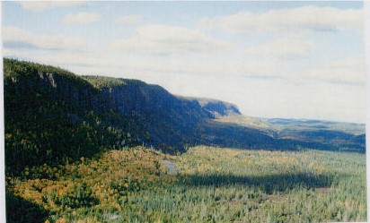
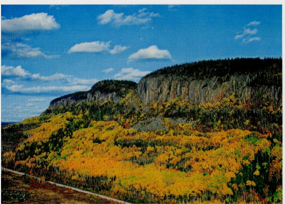
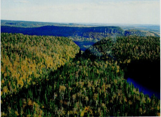
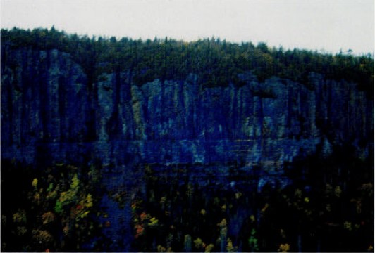
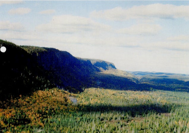
The Kama Cliffs Conservation Reserve contains an impression and easily accessed example of the rugged topography along the north shore of Lake Superior. Ontario’s smallest provincial park is located within the site. This site contains representative landforms and vegetation types, including sparse forests and conifer on strongly broken bedrock. More detail is available in the attached Earth Science Report and Life Science Report.
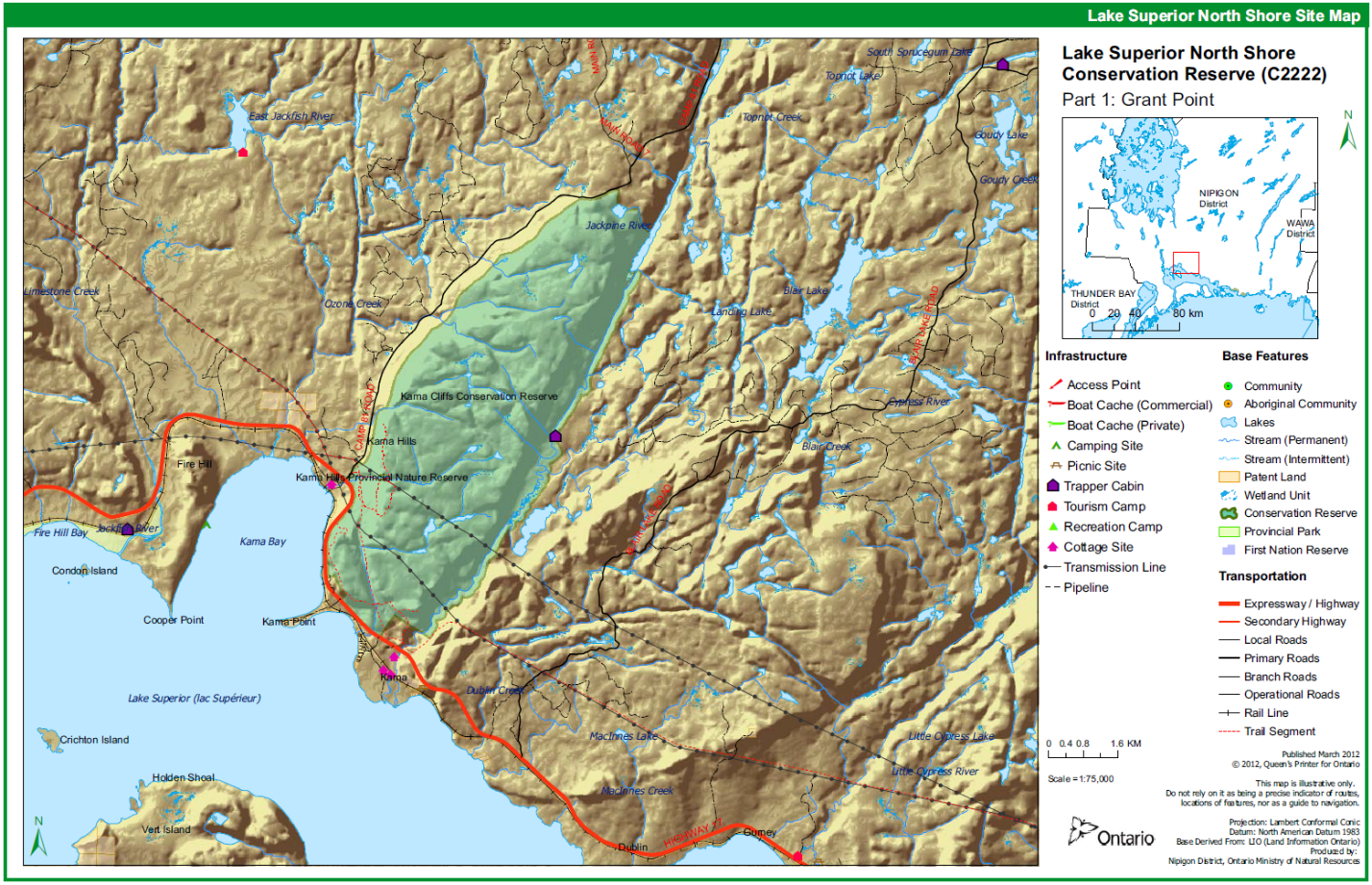
Access is gained to the vicinity of the site by way of Highway 17 and by way or logging roads which have been constructed nearby. One of the several hiking trails can be accessed from a highway rest stop that is located along Highway 17 adjacent to the conservation reserve. Access can also be gained via the Jackpine River.
The purpose of this Statement of Conservation Interest to identify the natural heritage values of Kama Cliffs Conservation Reserve and the activities which occur at this location. Through a set of management guidelines, this statement will outline the activities which will be permitted and those which will be prohibited. From this outline the management direction for the area can be determined.
2.0 Background information
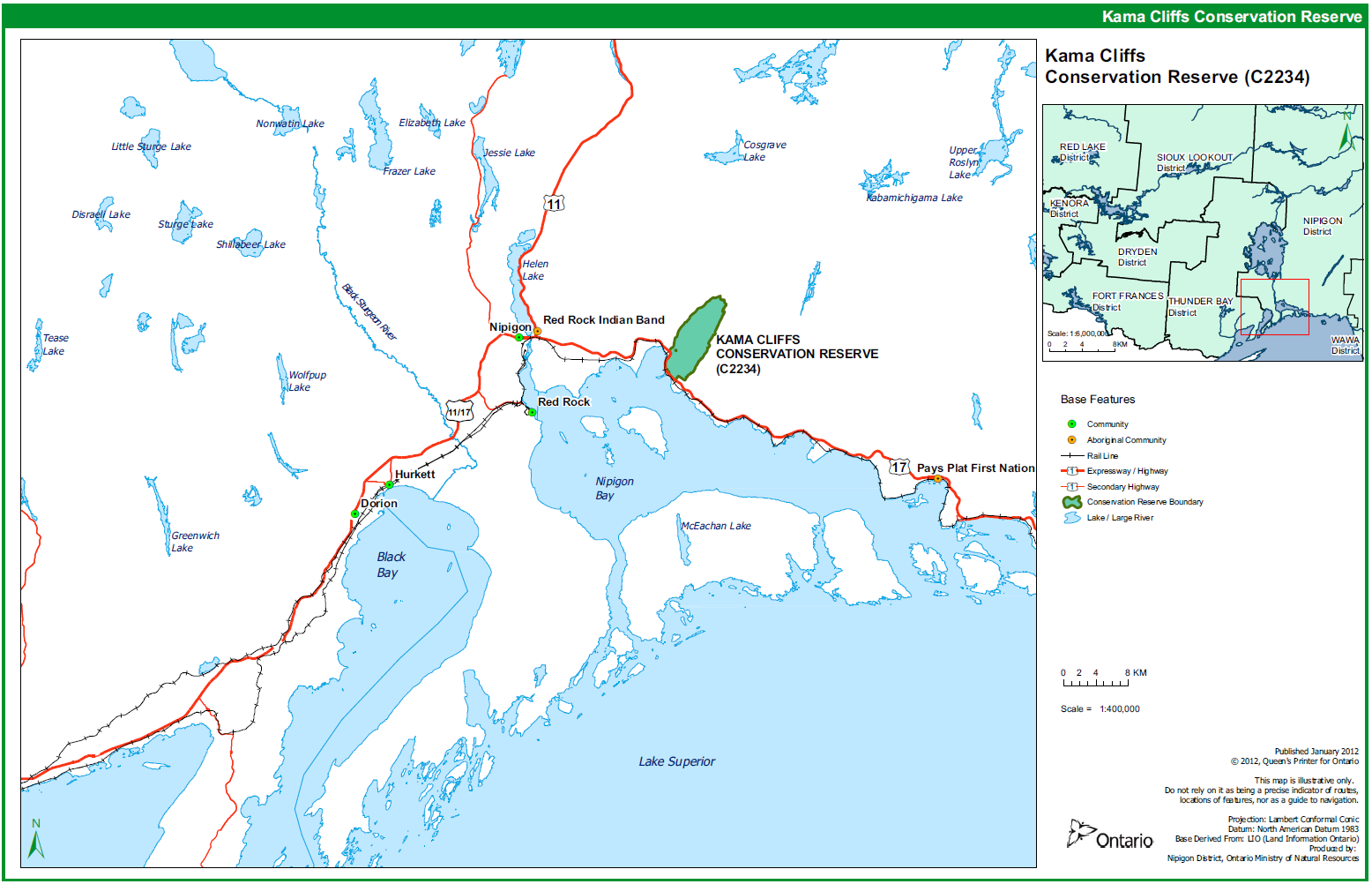
The Kama Cliffs Conservation Reserve is located 18 kilometers east of the Town of Nipigon, along the north shore of Lake Superior. The most prominent feature of the Kama Cliffs is the vertical bedrock exposure with heights commonly exceeding 200 meters. Along these cliffs, diabase Logan sills overlie red shales and mudstones of the sedimentary Sibley Group. Atop the Kama cliffs, the diabase Logan sills are overlain by a thin, discontinuous till that varies from sandy loams to sandy clay loams. Deciduous dominated mixedwood forest is common on upland, well drained sites. Conifer dominated mixedwood and pure conifer forests are less common.
Content formerly formatted as a table.
Description: Overview data describing Kama Cliffs Conservation Reserve and location.
Ecoregion/ecodistrict: 3W-3
OMNRF administrative region / district / area: Northwest/Nipigon/Nipigon East
Total area (ha): 3713 ha
Regulation date: June, 2000
First nations: Pays Plat First Nation, Red Rock First Nation
Ontario Base Map (OMB): 16 4200 54200, 16 4200 54300, 16 4300 54200, 164300 54300
Latitude/longitude: 49°00′00″ / 88°00′00″
Basemap: 488874, 488881, 491874 and 498881 (c.1975)
FRI stands: 1, 2,3, 5”, 6, 7, 8, 9, 10,11+,12+, 13,14,15+,16, 17, 19+, 253, 254, 255, 256, 257, 258, 267, 269, 270, 271, 287, 288, 259, 290, 291, 292, 293, 294, 297, 298, 296,300, 301,302, 303, 304, 306, 307, 300,333. 334, 335, 336. 339, 340. 341, 342, 351, 474,477, 470,479, 4015, 481, 482, 483, 484,485, 486, 487, 489,490, 491, 493, 494, 495, 496,497, 498, 499, 500.501.302.503.554, 505, 507, 508, 509, 510, 511, 512, 513,514.515, NB: These stands either fully or partly fall in the conservation reserve.
*May be part of E2230, Lake Superior Shoreline
General location description: Located 18 kilometres east of the Town of Nipigon on the north shore of Lake Superior
Access: The area is accessible by motor vehicle, hiking. snowmobile and canoe via the Jackpine River.
3.0 Representation targets
This section provides a summary of the earth science, life science and cultural resource values represented. It also outlines existing and potential recreational opportunities available. Table of values and representation
Description: Summary of earth / life science and cultural representation as well as recreational opportunities
Life science representation: Provincially significant mature, deciduous dominated mixed wood forest on till coveted mesa-cuesta plateau terrain. The steep bedrock cliffs provide potential nesting and foraging habitat for peregrine falcons.
Earth science representation: Steep vertical cliffs provide an excellent view of both diabase Logan sills and of the Sibley Group Kama Hill Formation. Post glacial erosion has resulted in the development of recent colluvial material which is uncommon in Northwestern Ontario.
Cultural resource representation: Pays Plea First Nation have indicated that there are some ceremonial lakes where band members go for healing purposes.
Recreational opportunities: Opportunities exist for wildlife viewing, hiking and snowmobiling. A recognized snowmobile trail passes through the Conservation Reserve. As well, a small group of people have developed (prior to the designation as a protected idea) and maintain a hiking trail system within the CR. Fishing, hunting and canoeing opportunities are present—most notably along the Jackpine River.
4.0 Survey information
This section provides an overview of the inventories completed, their level of detail and any further inventories needed. Table of inventories completed
Description: Inventories completed and future requirements
| Survey Level | Life Science | Earth Science | Cultural | Recreational |
|---|---|---|---|---|
| Reconnaissance | Yes, February 2001 | Yes, February 2001 | Yes | Yes |
| Detailed | No | No | No | No |
| Requirement | No further requirement | No further requirement | No further requirement | No further requirement |
5.0 Values to be protected
This section provides a description of the key natural heritage values on the site and their condition relative to past resource use and management activities. It also addresses the sensitivity of these values to future land use and management activities.
| Value | Description |
|---|---|
| Cultural | Pays Plat First Nation have indicated that there are some ceremonial lakes where band members go for healing purposes. |
| Aboriginal Interests | Trapping, traditional hunting and gathering |
| Tourism | Then are some biking trails—which offer excellent views of Lake Superior and some islands. A recognized snowmobile trail also passes through the Conservation Reserve. |
| Recreational Fishing | The Jackpine River is within the Conservation Reserve. It is known locally and excellent fishery for rainbow trout and brook trout. |
| Recreational Hunting | There is some potential. The best access may be via the Jackpine River. The cliffs and rugged terrain may be limiting for general access. There are two Bear Management Areas which contain portions of the Conservation Reserve. |
| Mining | No active claims, staking or exploration in the Conservation Reserve, The area has been withdrawn from staking by means of a withdrawal order. |
| Aggregate | At the expiry of the aggregate permit (MTO 500 204) for Forest Reserve F2234, the 10 hectares of land associated with this permit will revert to the Crown and be included into the CR lands. Any aggregate extraction or maintenance activities which occur in Forest Reserve F2234 will occur outside of the peregrine falcon’s critical nesting /rearing season (month to month). |
| Forest Harvest | Mature forest cover on the site is commercially merchantable. |
| Wild Rice | None observed on site |
| Trapping | Traplines NG116 and NG 118 each contain portions of the Conservation Reserve. |
| Wildlife | The Conservation Reserve was determined to have high potential for use by peregrine falcon plan and has subsequently been the site of several releases. The conservation reserve continues to be considered to have high potential for peregrine falcon recovery activities and is monitored regularly in accordance with the Peregrine Falcon Recovery Strategy (Ontario Peregrine Recovery Team 2010). |
| Commercial Fisheries | None present. Four baitfish blocks contain portions of the Conservation Reserve. |
The intent of this Statement is to protect those values identified on site by establishing guidelines for existing and potential uses in this area, given the level of past disturbances and the nature of existing features.
Forest Values - The entire forested area is to be protected (including the Old Growth component) from human disturbance. The forest cover on this site is representative of upland areas within ecodistrict 3W-3 and is predominantly fire origin mature stands.
Recreational Values - The site accommodates hiking, scenic viewing, landform viewing, plant and wildlife viewing, fishing, hunting, canoeing and snowmobiling.
Tourism Values - This highly attractive site provides a number of lookouts onto Lake Superior and its coastline.
First Nation Values - Pays Plat First Nation have indicated that there are some ceremonial lakes where band members go for healing purposes. Native trappers are very likely using the site, although there have been no harvest reports submitted in recent years. Given the terrain, the proximity to Lake Superior and the presence of the Jackpine River, it is highly likely that the site was used in the past.
6.0 Management guidelines
The following topics briefly indicate the existing situation on Kama Cliffs Conservation Reserve and the management guidelines to be implemented or continued.
6.1 Land tenure
Kama Cliffs Conservation Reserve consists entirely of Crown Land. The entire reserve is permanently withdrawn from any mineral exploration and from disposition by sale or Crown Lease or Land Use Permit. No new land tenures will be considered within the conservation reserve boundaries
Existing developments in the conservation reserve (see 6.2 Existing and Proposed Developments) hold a variety of different forms of land tenure including Land Use Permits, Crown Land Easements, and Letters of Authority. In addition, Kama Hills Provincial Nature Reserve (P2662) is located inside the conservation reserve. However, the area associated with this park (one hectare) is not considered to be part of the conservation reserve.
6.2 Existing and proposed development
The following exist within the Kama Cliffs Conservation Reserve,
- Radio tower (Domtar Forest Products)
- Hiking trails
- Snowmobile trails
- Two Transmission Lines (Ontario Hydro)
- Cabin
- Bridge (abandoned)
No new facilities or development will be permitted for any purpose — although maintenance of the existing developments is anticipated. The area will be managed primarily for public nature appreciation, educational teaching and scientific study. In order to reduce potential site degradation, tourism will not be promoted.
Highway # 17 offers ready access to the southern portion of the site.
6.3 Recreational activities
Low intensity, non-structural recreational activities that do not impact on the health of the forest ecosystem (i.e. viewing, hiking, hunting, fishing, canoeing) are permitted. Activities such as snowmobiling will generally be permitted to continue on existing trails. However, snowmobile and ATV usage will be closely monitored for any potential adverse effects on the values being protected on site. If site degradation occurs these, activities may have to be regulated within the reserve. Use of the existing hiking trails will also be monitored to determine impacts upon the reserve.
6.4 Commercial activities
The site forms a part of two active traplines. Trapping will continue as a permitted use. The site also falls within two Bear Management Areas and four Bait Fish Harvest Licence Areas. Both of these uses will be permitted with the condition that no new trails or other development are allowed without specific authorization. Two hydro-electric transmission lines also pass through the site. They will continue as a permitted use.
No other commercial activities exist within the Conservation Reserve boundaries and no new ones will he permitted (i.e. mining. hydroelectric development, logging, aggregate extraction, road development, utility corridors, peat development and topsoil removal)
Careful mineral exploration may occur in specific new Conservation Reserves proposed through Ontario’s Living Legacy Land Use Strategy, in areas that have provincially significant mineral potential. If a portion of the new Conservation Reserve is to be developed for a mine, it would be removed from the reserve and appropriate replacement lands would he placed is regulation.
The area has been permanently removed from the operable area of the Lake Nipigon Forest Sustainable Forest Licence. The site has been withdrawn from area available to ruining exploration and extraction activities.
6.5 Aboriginal interests
Local First Nations were asked to provide input to the regulation of this (and other) Conservation Reserve. Pays Plat First Nation indicated that they have ceremonial lakes located on the Conservation Reserve, where band members go for healing purposes. Nothing in this Statement of Conservation Interest affects in way existing or future aboriginal or treaty rights. These rights will continue to be respected.
6.6 Natural resources stewardship
6.6.1 Vegetation management
The area will be managed in accordance with relevant existing policies. The natural ecosystem processes and features will, for the most part, be allowed to occur with minimal human interference. However, intensive fire management and protection will continue to be carried out on site unless en alternative direction for the control of it is approved through a more detailed local natural resource plan or management plan.
6.6.2 Fish and wildlife management
Fishery and wildlife will continue to be managed in accordance with existing policies and regulations. Opportunities for wildlife viewing will be encouraged.
The Kama Cliffs Conservation Reserve has been part of the network of locations that the MNR has used as part of the Peregrine Falcon Recovery Program. Sites at the Kama Cliffs Conservation Reserve have been used as release locations and several ledges are regularly monitored in accordance with the Government-led actions listed in the recovery plan (Ontario Peregrine Falcon Recovery Team 2010, OMNR N.d.).
6.6.3 Landforms
Generally, the spectacular landscape features will require little in the way of detailed planning. As viewing of these cliff faces is likely to be desirable to many people, viewing areas outside of the Conservation Reserve may be required.
Kama Hills Provincial Nature Reserve (P2662), which is located inside the conservation reserve boundaries, was created to protect Neohellklan Rift Valley Environmental features located in the area.
6.7 Cultural resources stewardship
No requirements at this time based on existing information. The Ministry of Natural Resources will continue to work with the Ministry of Tourism and Culture’s regional chief archaeologist in identifying archaeological sites which should be protected, to date there has been no field survey to access cultural resources and the potential for archaeological finds is unknown.
6.8 Client services
Nipigon District and the Information Management Team staff will be the primary contact for responding to inquiries about the basic level of information such as access, nature appreciation, trails, scenic viewing, scientific study requests, wildlife viewing opportunities, hunting, fishing, canoeing, permitted uses, existing uses and boundaries.
6.9 Research
Non-destructive scientific research by qualified/recognized Canadian institutions or organizations that will contribute to the Ministry of Natural Resources natural heritage information base will be encouraged. All research programs will require the approval of the Ministry of Natural Resources and will be subject to ministry policy and other relevant legislation.
6.10 Marketing
No requirements at this time.
The trails located in the conservation reserve are described in several guide books published about the Thunder Bay and Kama Bay areas in general.
7.0 Implementation
Implementation of this Statement of Conservation interest will primarily involve monitoring activities to ensure adherence to management guidelines. Other activities will involve producing a fact sheet highlighting the importance of the reserve and responding to inquiries about the site. Any affected clients will be immediately notified of any amendments to this Statement of Conservation Interest.
The Kama Cliffs Conservation Reserve was regulated in June, 2000 under the Public Lands Act following the process set out in Ontario’s Living Legacy Protected Areas Regulation Implementation Manual (MNR 2000) and is now governed by the Provincial Parks and Conservation Reserves Act, 2006.
8.0 Review and revisions
Any changes that may occur to the management direction outlined in this Statement of Conservation Interest for Kama Cliffs will be evaluated for their significance. Minor changes, which do not alter the overall protection objectives, may be considered and approved by the Area Supervisor. Local consultation may also be required, as determined by the Area Supervisor. In the case of major changes, the need for a more comprehensive Conservation Reserve Management Plan win be considered first, along with any legislative notification requirements (such as the Environmental Bill of Rights Registry notification) that may exist at that particular time. Any major amendments will require full public consultation and the approval of the District Manager and Regional Director.
In accordance with the Provincial Parks and Conservation Reserves Act, 2006, MNR will annually examine management direction documents that have been in place for 20 years or more. The next scheduled examination for the Kama Cliffs Conservation Reserve will be in 2021.
9.0 Public consultation
9.1 Results of past consultation
Kama Cliffs has been part of the consultation process from early in the Land use planning process:
- Lands for Life round table consultation (June 1997 to July 1998)
- Ontario Forest Accord (1999)
- Ontario Living Legacy round table discussions (1999)
- OLL Site Regulation Public Consultation Process (Fall 1999 in Early 2000)
Under the Ontario’s Living Legacy Land Use Strategy, contact was made with stakeholders. District Manager letters were sent to First Nation, forestry industry, trappers, Municipalities, landowner, prospectors, fish and game clubs, trail club and tourist operators in November 1999. Newspaper advertisements were distributed during this time. Four written comments were receive regarding Kama Cliffs Conservation Reserve (see Appendix). Pays Plat First Nation noted that these axe ceremonial lakes within the Conservation Reserve where hand members go for healing purposes. They indicated that they would wish to be contacted during any future planning for development within the site.
9.2 Future consultation
Widespread consultation is not deemed necessary at this time because of the extensive consultation that has occurred to date.
10.0 References
Ontario Ministry of Natural Resources. 1999. Ontario Living Legacy Use Strategy, Queen’s Printer for Ontario. Ontario, Canada.
Ontario Ministry of Natural Resources. 2000. Protected Areas Regulation Implementation Manual, Internal Document.
Ontario Ministry of Natural Resources. 2011. Ontario Protected Areas Planning Manual. Peterborough. Queen’s Printer for Ontario. 50 pp.
Ontario Peregrine Falcon Recovery Team. 2010. Recovery Strategy for the Peregrine Falcon (Falco peregrinus) in Ontario. Ontario Recovery Strategy Series. Prepared for the Ontario Ministry of Natural Resources, Peterborough, Ontario. vi + 36 pp.
Ontario Ministry of Natural Resources. N.d. Peregrine Falcon Ontario Government Response Statement. Queen’s Printer for Ontario. 5 pp.
Appendix 1. Key map
Appendix 2. Map of Kama Cliffs Conservation Reserve
Appendix 3. Photographs
Appendix 4. Permitted uses table
| Activity / Value | Permitted | Not Permitted | Modified | District Manager Approval |
|---|---|---|---|---|
| Sport Hunting | Yes | |||
| Commercial Trapping | Yes | |||
| Boating / Canoeing / Kayaking | Yes | |||
| Baitfishing | Yes | |||
| Commercial Wild Rice Harvest | (N/A) | |||
| Mineral Exploration & Extraction | Yes | |||
| Land Disposition for Private Purposes | Yes | |||
| All-Terrain Vehicle | Yes | |||
| Snowmobile | Yes | |||
| Land Claims | Yes | |||
| Traditional Use | Yes | |||
| Native Hunt Camps | Yes | |||
| Commercial Tourism Based Hunting | Yes | |||
| Native Hunting | Yes | |||
| Commercial Native Trapping | Yes | |||
| Wildlife Management | Yes | |||
| Commercial Forest Operations | Yes | |||
| Vegetation Management (i.e. herbicides) | Yes | |||
| Timber Harvest for Personal Use | Yes | |||
| Fuelwood Harvest | Yes | |||
| Insect & Disease Suppression | Yes | |||
| Sport Fishing | Yes | |||
| Commercial Fishing | N/A | |||
| Native Fishing | Yes | |||
| Water Control Structures | Yes | |||
| Aggregate Extraction | Yes | |||
| Bear Management Areas | Yes | |||
| Trapline Cabins | Yes | |||
| Wild Rice Harvest | N/A | |||
| Boat Caches | Yes | |||
| Fire Management | Yes | |||
| Archeological Study | Yes | |||
| Backcountry Travel | Yes | |||
| Wildlife / Vegetation Viewing | Yes | |||
| Photography | Yes | |||
| Hiking | Yes | |||
| Rock Climbing | Yes | |||
| Mountain Biking | Yes | |||
| Nordic Skiing | Yes | |||
| Snowshoeing | Yes | |||
| Aircraft | Yes | |||
| Roads / Bridges / Culverts | Yes | |||
| Ongoing Research | Yes | |||
| New Research | Yes |
Definitions: modified-use may be permitted under certain circumstances where the use would not impact the values of which the Conservation Reserve was created to protect (e.g. new trails, clearing/docks for aircraft access).