Kashabowie Provincial Park Management Statement
This document provides direction on the management of Kashabowie Provincial Park.
Interim Management Statement
Regional Director’s approval statement
Kashabowie Provincial Park
This revised Interim Management Statement will provide interim direction for the management of the above Provincial Park until a comprehensive Park Management Plan is prepared.
This statement will provide the basis for the subsequent preparation of the Park Management Plan.
I am pleased to approve this Interim Management Statement.
Signed by:
M.S. Millar
A/Regional Director
North Central Region – Thunder Bay
Revised March 1991
Background information
Date: 15.06.85
| Name: | Kashabowie |
|---|---|
| Class: | Natural Environment |
| M.N.R. District | Thunder Bay |
| M.N.R. Region | North Central |
| Total Area (ha): | 2,055 |
| Land: | |
| Water: | |
| Site Region: | 4W |
| Site District: | 1 |
| Date in Regulation | June 15, 1989 |
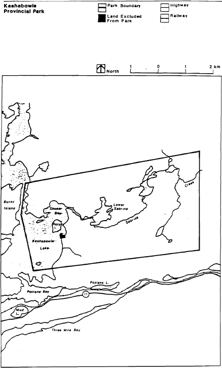
Map: Kashabowie Provincial Park
Targets
Life science representation
| site type/landscape unit | species/communities |
|---|---|
| Moderately broken shallow sand till over Archean bedrock with loess dep. Moderately broken loess plain. | Diversity of wetland types, including bogs, swamps, shoreline and fluvial marshes. Only site region representation of loess dep. |
Earth science representation
| geological theme | feature |
|---|---|
| Algonquin Stadial | Lake Kaministiquia - Kashabowie Spillway |
Cultural resource representation
| theme | theme segment |
|---|---|
| Unknown ( high potential for sites) |
Recreation opportunities
| day use | car camping | wilderness/back country |
|---|---|---|
| 2450 (minimum) | 5800 (minimum) | N/A |
Inventories
| level/type | reconnaissance/completion date | detailed/completion date | required? |
|---|---|---|---|
| life science | checksheet | Bardecki and Boles, 1972 | |
| earth science | checksheet | Bardecki and Boles, 1972 | |
| cultural | detail inventory | ||
| recreational | |||
| other |
I Land tenure
All land within the Park is Crown Land. One patented cottage lot is surrounded by the Park, but is excluded from it.
Guideline:
Granting of tenure will not be considered for any land within the Park.
II Land acquisition/disposition
There are 35 surveyed cottage lots within the Park area. One of these lots is privately owned (Parcel PP600) and is excluded from the Park. (The names and addresses of cottage owners are on file in the Thunder Bay District Office.)
Guideline:
Patented Parcel PP600 is excluded from the Park.
Cottaging will not be permitted within the park area; and disposition of the lots will not take place.
No consideration will be given to acquiring additional land or disposing of land within the Park until a Management Plan is completed.
III Existing/Proposed development
There is no existing or proposed development at the present time.
Guideline:
Development (excluding that related to public health and safety) will not be undertaken prior to completion of a Management Plan.
The boundaries for this Park will be surveyed and cut, and appropriate signage provided, if funding permits.
IV Recreational activities
The recreational activities which presently take place in the Park are canoeing, hunting, boating and sport fishing. No data is available on levels of use.
Guideline:
All of the above activities will be permitted to continue.
Wildlife viewing will be permitted.
V Commercial activities
The Park comprises approximately 25% of the trapline area #112 and 20% of trapline area #130. (The trapline data is on file in the Thunder Bay District Office.)
The Park comprises less than 5% of Bait Fish Licence area #T.B.-43. (The Bait Fish Licence data is on file in the Thunder Bay District Office.)
No other commercial activities take place within the land portion of the Park area.
Water based recreation activities, originating from commercial tourism establishments outside of the Park area do take place.
Guideline:
Trapping will be phased out by January 1, 2010 or when the trapper retires or dies, whichever is sooner. At that time, those portions of the licence within the Park will be removed. Where a trapper’s licence lapses, the licence will not be renewed. No new licences will be issued.
Bait fishing, commercial fishing, forestry, mining and aggregate extraction will not be permitted in the Park.
All other existing water based activities will be allowed to continue.
VI Natural resources
Kashabowie is classified as a Natural Environment Provincial Park.
Guideline:
Should any unforeseen conflicts or threats to significant resources arise, appropriate measures and/or restrictions will be implemented.
Normal forest fire suppression will take place within the Park area.
Until appropriate measures are identified in a Management Plan, insects and diseases will be controlled as is deemed necessary.
VII Cultural resources
Two archaeological sites have been identified within the Park. The potential for more sites is considered high.
Guideline:
Any disturbance of archaeological sites within the Park will be discouraged, and restrictions on activities on or near the sites will be implemented if necessary.
VIII Client services
No literature is presently available.
Guideline:
Client services will not be provided, except as required by legislation or M.N.R. policy.
IX Research and inventories
Detailed earth and life science inventories have been completed for Kashabowie Provincial Park.
Guideline:
A detailed archaeological inventory will be required prior to completing a Management Plan.
Additional research inventories will be encouraged to further document Park values. These may be carried out by M.N.R. or by outside interest groups/individuals. Any research must first be approved by the District Manager.
References/sources
Bardecki, M. and B. Boles. 1972. The Geomorphology, Vegetation and Floristics of Kashabowie Park Reserve. O.M.N.R.
O.M.N.R. 1983. Backgrounder Land Use Guidelines.
O.M.N.R. 1983. Thunder Bay District Land Use Guide.
O.M.N.R. Thunder Bay District Sensitive Areas Report.
Map: Kashabowie Provincial Park boundaries