Killarney Lakelands and Headwaters Provincial Park Management Statement
This document provides policy direction for the protection, development and management of Killarney Lakelands and Headwaters Provincial Park and its resources.
Approval statement
I am pleased to approve this Interim Management Statement for Killarney Lakelands and Headwaters Provincial Park. Ontario’s Living Legacy Land Use Strategy (1999) has identified this area as a natural environment class provincial park. This provincial park was regulated under the Provincial Parks Act in June 2006 (O. Reg. 311/06).
This Interim Management Statement provides direction for the protection and management of Killarney Lakelands and Headwaters. Provincial Park.
March 6, 2007
Paul Bewick
Zone Manager
Northeast Zone
Ontario Parks
1.0 Introduction
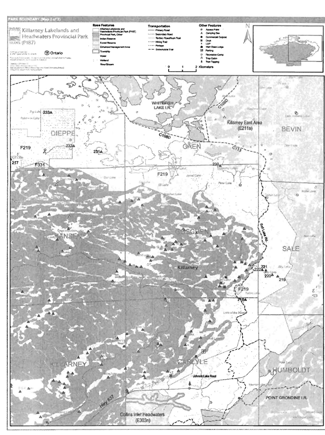
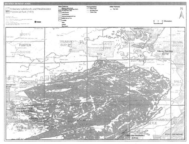
Killarney Lakelands and Headwaters Provincial Park (P187) is located to the northeast of the Town of Killarney and southwest of the City of Sudbury (Figure 1). The park protects the area surrounding the existing Killarney Provincial Park and associated wilderness additions. The park is located in the townships of Dieppe, Hansen, Goschen, Sale, Killarney, Carlyle, Humboldt, Truman, Roosevelt, Curtin, Bevin and Caen (Figures 2a and 2b). This 15,346 hectare park encircles three quarters of the existing Killarney Provincial Park and associated additions and follows the water’s edge of Lake Panache along the northern boundary of the wilderness park.
Killarney Lakelands and Headwaters Provincial Park was regulated in June of 2006 (O. Reg. 331/06). The park was designated through Ontario’s Living Legacy Land Use Strategy (OMNR 1999) as a natural environment class park. The purpose of this natural environment class park is to complement the ecological integrity of the existing Killarney Provincial Park while providing for a broader range of recreational uses than the adjacent wilderness class park.
1.1 Objectives
Killarney Lakelands and Headwaters Provincial Park will be managed consistent with the four objectives for provincial parks:
Protection: To protect provincially significant elements of the natural and cultural landscapes of Ontario.
Recreation: To provide provincial park outdoor recreation opportunities ranging from high intensity day-use to low-intensity wilderness experiences.
Heritage Appreciation: To provide opportunities for exploration and appreciation of the outdoor natural and cultural heritage of Ontario.
Tourism: To provide Ontario’s residents and out-of-province visitors with opportunities to discover and experience the distinctive regions of the Province.
2.0 Management context
The purpose of this Interim Management Statement (IMS) is to provide direction to ensure the custodial management of park resources. Future planning may be undertaken as required to provide direction on significant decisions regarding resource stewardship, development, operations and permitted uses.
Park management will follow direction from:
- Provincial Parks Act (1990) and regulations
- Ontario Provincial Parks Planning and Management Policies (OMNR 1992)
- Ontario’s Living Legacy Land Use Strategy and policy clarifications (OMNR 2000), amendments, and related direction
- Crown Land Use Policy Atlas (OMNR 2004a).
In addressing custodial management obligations to protect park values and ensure public health and safety, Ontario Parks will ensure that policy and Environmental Assessment Act (1990) requirements are implemented.
A map of the regional setting of Killarney Lakelands and Headwaters provincial park.
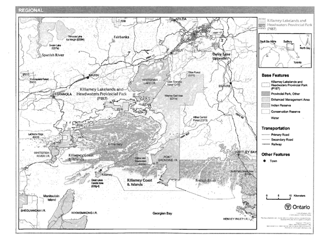
Enlarge this map of the regional setting of Killarney Lakelands and Headwaters provincial park.
A map of the western boundray of the Killarney Lakelands and Headwaters Provincial Park.

A map of the eastern boundary of the Killarney Lakelands and Headwaters Provincial Park.
2.1 Environmental assessment
As a part of the Ontario Ministry of Natural Resources (MNR), Ontario Parks is a public sector agency which is subject to the Environmental Assessment Act. Park management will be carried out in accordance with legislation, policies, and guidelines that are required under A Class Environmental Assessment for Provincial Parks and Conservation Reserves (OMNR 2005a).
3.0 Park features and values
Killarney Lakelands and Headwaters (P187) was identified as a result of the strategic planning process in Ontario’s Living Legacy Land Use Strategy (OMNR 1999). This natural environment class park protects provincially and regionally significant terrestrial ecosystems and species as well as provincially significant bedrock transition zone from the Grenville Province to the Southern Province (Mainguy and Tegler 2003; Kor 2007). The boundary is ecologically based, as it includes the headwater limits of the adjacent Killarney Provincial Park, a wilderness class park (Mainguy and Tegler 2003).
3.1 Geological features
Killarney Lakelands and Headwaters includes rugged topography, consisting of bare bedrock knolls and ridges. The area encompasses a cross-section of rocks eastward from the Killarney Front Tectonic Zone, across the Grenville Front, through the Killarney Magmatic Belt and into the Southern Province. Bedrock exposure is extensive throughout the park. Surficial deposits consist primarily of a thin, discontinuous veneer of glacial till, postglacial fluvial sediments, and, topographic hollows filled with small lakes and wetland vegetation.
The park adds to the representation of bedrock elements which encompass the transition from the Grenville Province to the Southern Province. This transition is not found elsewhere with the protected areas of the region and thus the occurrence in this park, is considered provincially significant.
3.2 Biological features
Killarney Lakelands and Headwaters Provincial Park is located within Ecodistricts 5E-3, 5E-4 and 5E-7. The park was established to protect provincially and regionally significant terrestrial ecosystems, as well as the headwaters of Killarney Provincial Park - wilderness class. The park encompasses several large lakes and several headwater areas including Howry Creek Headwaters West, the Killarney North Central Headwaters, Mahzenazing North Headwaters and Sale Township natural heritage areas (Mainguy and Tegler 2003).
The main forest representation types within the park include white pine-red pine forest, poplar white birch forest, sugar maple forest, red oak-red maple forests, hemlock forest, as well as mixed poplar-birch. The majority of forests within the park range from 50-120 years in age, however there is some candidate old growth forest within the park (Mainguy and Tegler 2003).
Wetlands include marshes and open poor fens, semi-treed and treed poor fens, conifer-lowland hardwood swamps, and cedar-black spruce-tamarack swamp. Most open wetlands occur as one to five hectare patches, while most forested wetlands are less than one hectare in area. However, there are two wetlands that are over 30 hectares in size and occur along the central south shore of Lake Panache, north of Bear Lake (Mainguy and Tegler 2003).
The park encompasses a high diversity of forest and wetland types and maintains a wide range of wildlife including reptiles, amphibians, as well as area sensitive bird species. There are two provincially significant plant species, the prickly hornwort and hidden-fruited bladderwort, as well as, five regionally significant plant species within the park. One provincially significant wildlife species, the Caspian tern is found within the park. An additional nationally significant wildlife species, the eastern Canadian wolf, is also present within the site (Mainguy and Tegler 2003).
The lakes within Killarney Lakelands and Headwaters Provincial Park have been affected by acid precipitation, but are generally less sensitive than those within Killarney Provincial Park. Most lakes have a pH of over 6.0 and sustain a higher level of fish diversity than similar lakes within Killarney Provincial Park (Mainguy and Tegler 2003).
3.3 Cultural setting
An investigation into the cultural features specific to Killarney Lakelands and Headwaters, Provincial Park has not been completed at this time.
Any future planning will be within the context of a provincial framework, A Topical Organization of Ontario History (OMNR 1974). In addition, updates and discussions with First Nations and other agencies and stakeholders may be carried out to identify cultural heritage values and features within the park and their significance. This information may be used to develop management guidelines to conserve and protect representative archaeological and historical values and features, or to provide direction for further research.
3.4 Recreation
Recreation features are biophysical features that support recreational activities within the park. Recreation features within the Killarney Lakelands and Headwaters Provincial Park include lakes, sport fish, developed snowmobile trails, potential canoe routes and headwater areas. There are a variety of lakes with Killarney Lakelands and Headwaters Provincial Park; some of the larger lakes include Bear Lake; Little Bear Lake, Walker Lake, Plunge Lake, Horseshoe Lake, Peter Lake, and a portion of Lake Panache. There are two OFSC snowmobile trails that pass through the park, C113 and C108D, as well as additional snowmobile trails that run through sections of the western portion of the park. There are numerous possible canoe routes within the Killarney Lakelands and Headwaters Provincial Park. Many of these canoe routes could connect to the existing Killarney Provincial Park and associated additions (P331) (Harper 2003).
Killarney Lakelands and Headwaters Provincial Park supports a variety of existing recreational activities but also has the potential to support new activities. The park supports snowmobiling, fishing and boating. Authorized OFSC snowmobile trail C113, located on the east side of the park, and a small portion of authorized OFSC trail C108D, located on northwestern side of the park, provide for a scenic snowmobile ride. Additional snowmobiling may also take place within the park on existing unauthorized trails. Boating and fishing, for species such as walleye, northern pike, lake trout, small mouth bass, largemouth bass, whitefish, and perch, is known to occur within most of the numerous lakes of the park. The park can also support various potential activities such as canoeing, camping, nature activities and hiking. The numerous lakes within and adjacent to the park could easily be incorporated into the existing canoe routes of Killarney Provincial Park. In fact, an additional 12 portages will be added to Killarney Lakelands and Headwaters Provincial Park and the Killarney North Forest Reserve for the 2007 operating season. Camping may also be occurring in the park, over 75 unmanaged campsites were identified within park and adjacent forest reserve area. During the 2007 operating season 32 of those campsites will be managed and ·available for public use (C. Miller, Personal Communication, February 7, 2005). Hiking may also be a potential recreational activity for this park, while extensive work would be required to connect this area to the existing trail network of Killarney Provincial Park, this would provide increased opportunities for park visitors. Nature activities such as drawing, painting and photography already occur within the existing Killarney Provincial Park. These activities· could easily occur within the scenic Killarney Lakelands and Headwaters Provincial Park (Harper 2003).
4.0 Aboriginal uses
Killarney Lakelands and Headwaters Provincial Park lies within the Robinson Huron Treaty of 1850. White Lake First Nation is located north of the park and park additions, while Whitefish River First Nation is east of the park and park additions, Wikwemikong Unceded Nation and Sheguiandah First Nation are located on Manitoulain Island south east of the park and park additions. Point Grondine Indian Reserve, which includes individuals from Wikwemikong Unceded Nation is located directly east of the Sinkhole Bog portion of the addition and southeast of the Howry Creek Headwaters-East.
Consultation related to the boundary regulation of the park was undertaken with Zhiibaahaasing First Nation, Sheguiandah First Nation, Ojibways of Sucker Creek, M'Chigeeng First Nation, Whitefish Lake First Nation, Sagamok Anishnawbek First Nation, Sheshegwaning First Nation, Wikwemikong Unceded Nation, Wauwauskinga (Whitefish River) First Nation and the Union of Ontario Indians (OMNR 2005b).
First Nations have expressed interest in and have shared knowledge of the park and surrounding area. Aboriginal communities have used the area for hunting, trapping, fishing, gathering and travel. These uses may continue, subject to public safety, conservation and other considerations.
Any communications and cooperation between Aboriginal communities and the MNR for planning and operations purposes will be done without prejudice to any future discussions or negotiations between the government of Ontario and Aboriginal communities.
5.0 Stewardship policies
The removal, damage or defacing of Crown properties, natural objects, relics, and artefacts is not permitted (Provincial Parks Act).
Non-native species will not be deliberately introduced into the park. Where non-native species are already established and threaten park values (i.e., has become invasive), a strategy to control the species may be developed (OMNR 1992).
5.1 Terrestrial ecosystems
5.1.1 Vegetation
Harvesting
Commercial forest operations are not permitted within the park (OMNR 1992).
The harvest of non-timber forest products such as club moss, Canada yew, etc., will not be permitted (OMNR 1992).
Existing authorized wild rice harvesting may continue. New operations will not be permitted.
There are no fuelwood cutting permits currently issued for the park. New permits will not be issued (OMNR 2000).
Insects and disease
Insects and diseases may be managed where the aesthetic, cultural, or natural values of the park are threatened (OMNR 1992). Control measures will follow guidelines established by the Ontario Ministry of the Environment (MOE) and MNR. Whenever possible, biological control measures will be given preference over the use of chemicals (OMNR 1992). Control of insects and disease will be subject to A Class Environmental Assessment for Provincial Parks and Conservation Reserves (OMNR 2005a).
Fire
Killarney Lakelands and Headwaters Provincial Park is located within the Great Lakes-St. Lawrence Fire Management Zone. Historically fires have occurred within Killarney Lakelands and Headwaters Provincial Park in the 1920's, 1930's and 1940s (Mainguy and Tegler 2003). In accordance with existing provincial park policy and the Forest Fire Management Strategy for Ontario (OMNR 2004b), forest fire protection will be carried out in the park as on surrounding lands. Whenever feasible, MNR's Forest Fire Management program will use techniques that minimize damage to the landscape, such as limiting the use of heavy equipment or limiting the number of trees felled during response efforts (OMNR 2004b). More specific fire management strategies for this park may be incorporated into the fire management plan for Killarney Provincial Park, which may be developed in the future.
Wildlife management
This park is located within Wildlife Management Unit 42. The removal or harassment of non-game animals is not permitted (Provincial Parks Act).
Hunting
Sport hunting is permitted to continue. Considerations of safety and conservation with respect to hunting may be made through future planning, which would include Aboriginal dialogue and public consultation (OMNR 2000).
The Fish and Wildlife Conservation Act (1997) and the Migratory Birds Convention Act (1994) govern hunting within the park. The Ontario Hunting Regulations Summary contains regulations specific to this area. The harvest of bullfrogs or snapping turtles is illegal in provincial parks.
Bear Management Areas
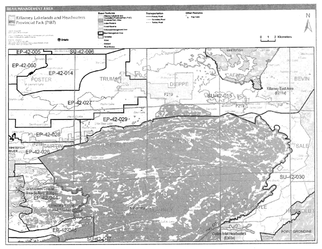
Killarney Lakelands and Headwaters Provincial Park includes portions of five bear management areas (BMAs): EP-42-044 (Killarney Township), EP-42-026 (Curtin Township), EP-42-028 (Curtin and Roosevelt townships), EP-42-029 (Roosevelt and Truman townships), EP-42-027 (Truman and Roosevelt township), SU-42-015 (Dieppe, Hansen, Caen, Goschen, Bevin and Sale townships) and SU-42-030 (Carlyle, Goschen, Sake, Humboldt and Sale townships) (Figure 3).
Existing commercial bear hunting operations are permitted to continue. This activity may be subject to conditions identified during future planning (e.g., the designation of nature reserve zones). New BMA licences will not be permitted (OMNR 2000; 2003a).
Trapping
Portions of eight licensed traplines are within the park: EP-43 (Curtin, Roosevelt, Truman and Hansen townships), SU-63 (Dieppe and Truman townships), SU-78 (Hansen Township), SU-79 (Caen and Goschen townships), SU-70 (Bevin Township), SU-80 (Sale, Humboldt and Carlyle townships) and SU-86 (Carlyle Township) (Figure 4). There are no trap cabins within the park however; there is one trap cabin within Killarney North Forest Reserve (F219) in Dieppe Township.
Existing commercial fur harvesting operations may continue where the activity has been licensed or permitted since January 1, 1992. New operations, including trap cabins and trails, will not be permitted (OMNR 2000; 2003a). Transfers of active trap line licenses are permitted, subject to a review of potential impacts and the normal transfer or renewal conditions that apply
A map of the Bear Management area of Killarney Lakelands and Headwaters Parovincial Park
A map of the Trapline area of Killarney Lakelands and Headwaters Provincial Park
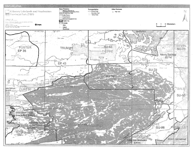
Enlarge this map of the trapline area of Killarney Lakelands and Headwaters Provincial Park (PDF)
5.1.2 Industrial resources
There are no pits or quarries located within the boundary of Killarney Lakelands and Headwaters Provincial Park. However, there is one active aggregate permit, Permit #16106, completely surrounded by Killarney Lakelands and Headwaters Provincial Park. This aggregate operation, known locally as the Bell Lake Quarry, pre-existed the park and is, therefore, not included within the park boundary and thus park policy does not apply. However, this area is currently designated as forest reserve and the future intent for this area is that it be incorporated as part of Killarney Lakelands and Headwaters Provincial Park. MNR district staff will work with the aggregate permit holder to ensure that as the quarry is worked, progressive and final rehabilitation of the site will occur, in such a manner which will allow the site to return to a natural condition (e.g., slope stabilization, native species plantings) and thereby result in plant succession that will blend in with surrounding lands. Site plan amendments to the existing aggregate permit may be considered, in order to provide for more specific rehabilitation prescriptions, which will eventually be included within the boundary of the park.
Aggregate extraction is not permitted in provincial parks unless it is allowed by regulation (Provincial Parks Act).
Mineral exploration and mining are not permitted within the park. The mining and surface rights on all lands within the park have been withdrawn from staking under the Mining Act (1990). In accordance with Ontario’s Living Legacy Land Use Strategy, however, access in the park to mining lands (i.e., forest reserve(s) and mining patents) will be permitted for purposes of mineral exploration, development, or operations. Access will be planned in accordance with the requirements of the Environmental Assessment Act.
5.1.3 Access and crossings
Access
The park is accessible by road, water and air at various locations. There are numerous possible access points to the park from various locations at local lodges and a marina in the area. Agreements to provide permit sales for access to Killarney Lakelands and Headwaters Provincial Park will be discussed with local businesses in the area. Access agreement with local resource harvesters, LUP holders and individuals with private in-holdings may be established.
The park is accessible via Lake Panache Road and Widgawa Lodge Road on the west side of the park, and via Bell Lake Road and Johnnie Lake Road from Highway 637 on the east side of the park. Other unnamed tertiary/forest access roads also provide access to the park.
Snowmobile trails C113, C1080 (0110) and two other non OFSC trails on the west side of the park provide access to the park. Some existing authorized and unauthorized tertiary/forest access roads and trails are used by ATVs. Portions of some of the snowmobile trails are known to be used by ATVs.
The park can be accessed by boat (e.g., motorboat, canoe etc.) from Lake Panache at a variety of locations.
The park can be accessed by aircraft. Some of the larger lakes in the park may be used by aircraft (e.g., Walker, Bear, Little Bear and Peter). Aircraft landings in the park require a valid permit issued by the park superintendent.
Motorized uses within the park will be further examined during future planning.
Roads
There are several roads located adjacent to and within Killarney Lakelands and Headwaters Provincial Park. These are discussed from northwest to east as follows.
Lake Panache Road provides access to the northern portion of the park in Truman Township. This primary access road is located directly adjacent to the park boundary near Walker Lake.
Widgawa Lodge Road, a tertiary access located in Curtin Township, as well as other unnamed tertiary access roads in the area provide access to the midwestern portion of the park. Portions of these roads are included with the regulated park boundary and also enter the adjacent forest reserve, Killarney North Forest Reserve (F219).
McRay Road is an additional secondary road that is located further south from the tertiary roads noted above. It provides access to the southwestern portion of the Killarney Lakelands and Headwaters Provincial Park. This road crosses through Shawshashigin Lake First Nation Indian Reserve and the Great Lakes Heritage Coast- Sudbury (E39g-6) Enhanced Management Area before arriving adjacent to a western tip of Killarney Lakelands and Headwaters Provincial Park.
Iroquois Bay Road is another tertiary access that diverges from the above noted secondary road. It provides access to a portion of the regulated boundary for the park and to patent lands including a lodge north of Iroquois Bay.
Bell Lake Road, located in Carlyle, Goschen, Sale and Bevin townships, provides access to a large portion of the eastern area of the park. Bell Lake Road is a long term haul road to access forest allocations adjacent to the existing Killarney wilderness park; it is also the primary access for visitors entering the Bell Lake portion of the wilderness park and a main base lodge and a commercial outpost camp on that lake. The Bell Lake road is gated nine kilometres from Highway 637, just beyond the turnoff to the Bell Lake entry facility. Beyond the gate, the 10 kilometre portion of this road is closed to all motorized traffic unless authorized by the MNR. An unnamed tertiary access extends beyond the end of the road as part of OFSC trail C113, which follows the road from Highway 637. A few tertiary access roads diverge from the existing OFSC trail/tertiary access road. Some of these tertiary access roads, along with existing unauthorized trails are used to access in-holdings, LUPs, resource harvest areas within and outside the park. Access needs with local LUP holders, resources harvesters and individuals with private in-holdings may be evaluated.
Johnnie Lake Road, located in Carlyle Township, also provides access to the south east portion of the park. This road provides access via Johnnie Lake and also may be used by adjacent local property owners. A few tertiary access roads, located east of Johnnie Lake Road, also could provide potential access to the park. These roads cross through the park in order to provide access to patent land on Johnny Lake between Killarney Lakelands and Headwaters Provincial Park and the existing wilderness park.
The decision to establish Killarney Lakelands and Headwaters Provincial Park included a provision to allow two additional forest access roads to be built within that park off the Bell Lake Road (OMNR 1999). These future crossing areas/roads were identified through Forest Accord #20 to provide the forest industry the opportunity to access timber harvest areas via road crossings of protected areas (OFAAB 1999).These new roads originate from Bell Lake Road and travel east to harvest areas outside the park. The first crossing, located east of Three Mile Lake, will go through the park in Sale Township. This road was approved in the 2005-2010 Forest Management Plan and will be identified in annual work schedules. The second road, which has not been planned as yet through an annual work schedule, is proposed to go through Carlyle and Sale townships. Further information on the original direction for the crossings can found on the Environmental Bill of Rights Environmental Registry under notice PB04E4001.
OFAAB Recommendation #20 also committed that, in all cases, an evaluation of each prospective crossing will be carried out by MNR to ensure that significant values are identified and protected. This would include on-site features, as well as upstream and downstream values such as water quality, fisheries habitat, recreation aesthetics, resource-based tourism infrastructure, etc. Background information will be used to determine the exact location and conditions of approval for each crossing. The final details will be the subject of detailed forest or park management planning.
MNR will require removal of these roads and bridges when no longer needed by the forest industry (i.e., when harvesting and renewal activities are completed). Conditions may also be placed these new road corridors in an effort to minimize the impact of access, particularly to water, within the park. Specific terms and conditions will be developed during detailed future forest or park management planning. They could include, but are not limited to, expedited harvest and silviculture, regulatory signs, barriers, road corridor/crossing design, seasonal restrictions on harvest, or use of temporary or portable bridges. Use of these roads to access other Crown resources (e.g., bait harvest, commercial trapline, bear management area) will be discouraged.
Environmental Assessment Act requirements have been met through a single evaluation and consultation process undertaken through Forest Management Planning.
Where existing forest access roads are essential for continued access beyond the park for forest management, access to in-holdings (i.e., land use permits, patents, etc.) or for recreation purposes, and alternative road access does not exist, or road relocation is not feasible, existing roads will continue to be available for access in interim. This use will be subject to existing restrictions, resource use agreements and any future strategies/plans developed through future planning. Continued use will include maintenance and may include upgrades (OMNR 2004a).
Ontario Parks is not responsible for the maintenance or upgrade of any of the above roads within the park boundary. Any proposed development, maintenance or upgrading of existing roads must meet all Environmental Assessment Act requirements.
Utility corridors
There are no hydro corridors within Killarney Lakelands and Headwaters Provincial Park.
All public utilities (e.g., gas pipelines, transmission lines, communications towers) must avoid park lands wherever possible. New utility corridor crossings may be necessary to maintain essential public services (OMNR 2004a).
Any future proposals for utility corridors through the park, where park lands are unavoidable, will be reviewed on a case-by-case basis. Protection of park features and values will be priority and all requirements of the Environmental Assessment Act will be met.
Recreational trails
Canoe Routes: There no specific documented canoe routes through Killarney Lakelands and Headwaters Provincial Park, however many of these lakes are used for recreational canoeing. The following 12 portage routes will be opened for the 2007 operating:
- Bell Lake Road to Turbid Lake
- Bell Lake to Grey Lake
- Peter Lake to Hideaway Lake (Panache)
- Brown’s Bay to Taylor Bay (Panache)
- Frank Lake to Brown’s Bay (Panache)
- Sasson Lake to Sawmill Bay (Panache)
- Newton Bay to Lake Panache
- High Lake to Sasson Lake
- Bear Lake to High Lake
- Walker Lake to Lake Panache
- Lake Panache to Horseshoe Lake
- Leach Lake to Plunge Lake (Whitefish River)
The maintenance of these portage links will allow for better public access to the lakes and thus for more canoeing opportunities. Some of these portages link Killarney Lakelands and Headwaters Provincial Park and the existing Killarney Provincial Park allowing for a variety of possible alternative routes.
Hiking Trails: There are no designated hiking trails within Killarney Lakelands and Headwaters Provincial Park. New trails (e.g., hiking) may be developed if the need arises. Any proposed development within the park is subject to Environmental Assessment Act requirements.
ATV Trails: There are no authorized ATV trails within the park boundary; however, there is existing unauthorized ATV use on forest/tertiary access roads and trails within the park. Existing use of these roads and/or trails to access private in-holdings, LUPs, resources harvest licenses (e.g., baitfish harvesting licenses, traplines, BMAs) and to pursue sport hunting and fishing opportunities, is permitted to continue in the interim, unless this use threatens park values. Future use of these forest/tertiary access roads and unauthorized trails will be determined through planning, which will include full Aboriginal dialogue and public consultation. Off-road or off-trail use of ATVs will not be permitted within the park (OMNR 2000).
Snowmobile Trails: There is an existing authorized Ontario Federation of Snowmobile Clubs (OFSC) trail, C113, which travels through the eastern portion of the park in Carlyle, Goschen, Sale and Bevin townships. This OFSC trail continues past the end of Bell Lake Road until it exits the park at Lake Panache. A small section of another OFSC trail, C1080 enters the park at the Walker Lake access point. Two other non OFSC trails enter the park south of Lang Lake and south of Miller Bay and along Howry Creek. The trail that runs south of both Lang Lake and Miller Bay are known to be used as a shortcut to access the Town of Killarney, while the trail that runs along Howry Creek is likely use for local resources harvesting, access to LUPs etc. There are other existing unauthorized snowmobile trails within the park. The use of snowmobiles is permitted to continue on existing routes in the interim unless park values are threatened. Future use of existing snowmobile trails will be determined through planning and will include Aboriginal dialogue and public consultation. Off-trail snowmobile use is not permitted. New snowmobile trails may also be considered though future planning (OMNR 2000).
5.1.4 Adjacent land management
Forestry
The land adjacent to the park is located within the Sudbury Forest Management Unit (889) and the Northshore Forest Management Unit (680) (OMNR 2007).
The Sudbury Forest is currently managed by the Vermilion Forest Management Company Limited. The management plan for this forest is to be renewed in 2010.
The Northshore Forest is currently managed by Northshore Forest Incorporated. The management plan for this forest is to be renewed in 2010 (OMNR 2007).
Provincial parks
Killarney Provincial Park (P331e): This 49,325 hectare wilderness class park’s main entry point is located at George Lake, 100 kilometres south of Sudbury. Killarney is a vast and beautiful tract of wilderness, with crystal-blue lakes, a spectacular range of white quartzite ridges, pine, hemlock and hardwood forests and boggy lowlands. Killarney Provincial Park was regulated as a provincial park in 1964.The management of the park provides day-use, camping and backcountry recreation opportunities such as hiking and canoeing while protecting the parks provincially significant natural and cultural values. Included in the wilderness park is a 1,275 hectare wilderness park addition, the Howry Creek Headwaters-East and the Sinkhole Bog natural heritage areas (OMNR 1999). The Howry Creek Headwaters-East contains the headwaters for several lakes within the existing Killarney Provincial Park. The 127 hectare Sinkhole Bog complex, located east of the existing Killarney Provincial Park, and south of Hwy 637, is a provincially significant patterned peatland.
Forest reserve
Forest reserves are areas of natural heritage and special landscapes which overlap with pre existing mining lands, primarily claims and leases. These areas were placed under interim protection in order to remove lands from commercial forest operations, while still allowing for mineral exploration of pre-existing mining claims and leases. Policies for forest reserves are similar to the policies for new conservation reserves, except that mining and related activities are permitted in a forest reserve. Commercial forest harvest, new hydroelectric power development, and peat extraction will not be permitted, but most other resource and recreation uses will be permitted, provided they are consistent with the features and values being protected (OMNR 1999).
The original intent for these forest reserves was to regulate them as part surrounding provincial parks or conservation reserves once the claim or lease had been retired through normal processes. In an effort to achieve a degree of certainty regarding the regulation timelines of protected areas and future mineral exploration and development, a local land use planning process called 'disentanglement' was initiated in 2005 to consider proposals to reduce the number of forest reserves. The Ontario Prospectors Association (OPA) and the Partnership for Public Lands (PPL), with the assistance of MNR, developed recommendations to provide initial direction for the redesignation of forest reserves. The OPA and PPL recommended that some forest reserves be removed and the area redesignated as Crown land, some forest reserves were to be removed but replacement areas were to be sought, and some areas were to remain status quo, which meant that as the mining tenure lapsed through normal processes this area would be regulated as part of the park or conservation reserve (OMNR 2005c). The forest reserves associated with Killarney Lakelands and Headwaters Provincial Park are part of this disentanglement process.
Killarney North Forest Reserve (F219): This forest reserve is made up of several individual sections which are surrounded by the park, Lake Panache and two general use areas. This forest reserve is located within Ecodistrict 5E-3 and 5E-4 within Dieppe, Truman, Roosevelt, Goschen, Caen, and Curtin townships. Much of the forest reserve consists of rolling hills of sandy till deposits, lower hills and bare bedrock. The terrain is covered in stands of poplar, white pine, white birch, white spruce, red maple, balsam fir and red oak. Bassoon Lake, a lake trout lake is included within one section of the forest reserve. Wetlands and aquatic shorelines, which are not well represented elsewhere, are also found within the site. The land use intent for this forest reserve is that it continues to remain "status quo", as mining tenure lapses through normal processes, the area will be added to Killarney Lakelands and Headwaters Provincial Park. However, it should be noted that a section of this forest reserve, located on the east side of the park, is not under mining tenure. This area is currently under an active permit for aggregate extraction. Once the aggregate from this area has been extracted and the area rehabilitated, the permit area will be considered for inclusion within Killarney Lakelands and Headwaters Provincial Park. In order to prevent any future staking activity within the aggregate site, the area has been designated forest reserve. This will allow existing aggregate operations to continue but still protect the area for future inclusion into the park.
Killarney Forest Reserve (F331): This small area of forest reserve is located within Dieppe Township, surrounded by the Killarney Park Additions and Killarney North Forest Reserve, in close proximity to the Killarney Lakelands and Headwaters Provincial Park. The forest reserve covers a portion of a mining claim that overlaps into Killarney North Forest Reserve. The land use intent for this forest reserve is that it continues to remain "status quo", as mining tenure lapses through normal processes, the area will be added to the Killarney Park Additions.
Enhanced management areas
Three enhanced management areas surround the park.
Killarney East Area Enhanced Management Area (E211a): This 29,306 hectare remote access enhanced management area includes two large tourism lakes, Annie and White Oak Lake as well as the east end of Lake Panache. The area encompasses white pine forest and significant moose wintering areas and lake trout lakes. This area supports a wide range of industrial, commercial and recreational uses including forest harvesting, aggregate extraction, tourism operations, sport fishing, and hunting. Fish and wildlife management, in harmony with forest management, will dominate land use activities. Management of this enhanced management area will focus on the maintaining and/or re-establishing the remote character of the area through examination of the use of roads in the area, which has contributed to the over harvesting of fisheries and wildlife resources. Land use direction and resource management activities within this area will be compatible with protecting the recreational values of Killarney Provincial Park, and Killarney Lakelands and Headwaters Provincial Park.
Collins Inlet Headwaters Enhanced Management Area (E303n): This 2,093 hectare natural environment enhanced management area is located southeast of the Killarney Lakelands and Headwaters Provincial Park. This enhanced management area protects significant wetlands and the headwater area draining into Killarney Provincial Park, Killarney Lakelands and Headwaters Provincial Park and Killarney Park Additions. It also contains vegetation and landforms that are not found in other areas in the ecodistrict. Several moose wintering areas have been identified throughout the area. Wildlife management efforts will continue to monitor the deer, moose and elk populations in an attempt to increase population and harvest opportunities. Forest management is permitted, provided that it is consistent with the protection of Killarney Provincial Park, Killarney Lakelands and Headwaters Provincial Park, and the protection of headwater and wetland values. Natural heritage enhanced management areas are intended to protect significant natural values, while allowing for a range of resource uses.
Great Lakes Coastal Areas- Sudbury (D) Enhanced Management Area (E39g-6): This 1,395 hectare Great Lakes coast shoreline area is located directly adjacent to a portion of the west side of Killarney Lakelands and Headwaters Provincial Park. The area is characterized by rugged Canadian Shield topography, renowned for its scenic vistas with windswept pines. Bare bedrock is interspersed with pockets of shallow soils, with discontinuous vegetation cover. The area provides habitat for a wide variety of fish and wildlife species, including several vulnerable and threatened species. There are a number of significant wetlands and wetland complexes. A wide range of recreational activities is carried out in the area, including boating (large cruisers, as well as small boats, canoes and kayaks), hunting; fishing, camping and nature appreciation. Commercial tourism operations and areas with extensive cottage development occur on adjacent private land. This area will be managed to protect its outstanding beauty and sensitive ecosystems while promoting recreation and tourism potential. The majority of lands will be retained in public ownership.
General use areas
Killarney Lakelands and Headwaters Provincial Park is surrounded by five general use areas.
Highways No 6 and No 17 Hinterlands General Use Area (G2033): This 53,434 hectare area, lies between the LaCioche Mountains and more level agricultural areas along the Spanish River. A portion of this general use area is located directly adjacent to the west and northwest side of Killarney Lakelands and Headwaters Provincial Park. This area is primarily managed for recreation, cottaging, commercial tourism, electrical energy production and forest production. Management of this area will be directed towards maintaining a reasonably balanced multiple use.
La Cloche Mountains General Use Area (G2031): This 2,115 hectare area includes part of the La Cloche Mountains that parallel the shores of the Bay Islands and McGregor Bay. A portion of this general use area is located directly adjacent to the west side of Killarney Lakelands and Headwaters Provincial Park. Existing use in this area consists mainly of cottaging, hiking, canoeing and hunting. However, some commercial resource harvesting does occur. Management of this area will be directed towards maintaining a prime recreational landscape that compliments the Bay of Islands and McGregor Bay areas. Most other resource programs will be permitted.
Bay of Islands, McGregor Bay General Use Area (G2030): This 13,837 hectare area covers the portion of the North Channel known as Bay of Islands and McGregor Bay. This general use area is located adjacent to the west side of Killarney Lakelands and Headwaters Provincial Park. This area is an important cottaging and tourist area. Cottages, marinas, commercial tourist establishments and small service outlets are common. Management will be directed toward maintaining the status quo within this area which will include allowing for existing recreational uses to continue. Management activities will be compatible with the adjacent provincial park.
Lake Panache General Use Area (G2047): This 15,799 hectare area encompasses a portion of Lake Panache and the surrounding lands directly north of Killarney Lakelands and Headwaters Provincial Park. Lake Panache is an important lake trout lake, providing boating, angling, cottaging, canoeing, and camping opportunities. This area also supports forest harvesting, hydroelectric generation, aggregate operations, mineral exploration (except on islands of Lake Panache which were withdrawn from staking in 1926) and local tourism operations. Management will be directed toward protection of lake trout from development and use pressure, while allowing for existing commercial, industrial and recreational uses. Where conflicts arise between recreation and resource extraction activities, the impact on recreation values will be minimized, wherever possible. Management direction will complement the adjacent Killarney Lakeland and Headwaters Provincial Park.
Wanapitei River West General Use Area (G2044): This 57,347 hectare area includes the area south of the City of Greater Sudbury and includes the southern reaches of the Wanapitei River. A portion of this general use area is located directly adjacent to the east side of Killarney Lakelands and Headwaters Provincial Park. This area supports forest harvesting, aggregate extraction, and commercial hydroelectric generation. Common recreational activities in this area include sport fishing and hunting. Management will be directed toward sustaining fish and wildlife resources, and associated recreation and tourism opportunities, while providing for industrial uses on the landscape. Resource management will be complementary to the adjacent Killarney Lakelands and Headwaters Provincial Park as well as other provincial parks
Indian Reserves
There are three Indian Reserves that are located in close proximity to Killarney Lakelands and Headwaters Provincial Park. Whitefish Lake First Nation Indian Reserve is located northeast of the park. This Indian Reserve follows part of the northern boundary of Lake Panache and also encompasses some islands on the lake. Whitefish River Indian Reserve is located west of the park while Point Grondine Indian Reserve is found southeast of the park, south of Highway 637.
5.1.5 Land disposition
Killarney Lakelands and Headwaters Provincial Park is located within the townships of Dieppe, Hansen, Goschen, Sale, Killarney, Carlyle, Humboldt, Truman, Roosevelt, Curtin, Bevin and Caen This park is within MNR's Sudbury District.
New land disposition for the private use of individuals or corporations will not be permitted (OMNR 1992; 2000).
Land use permits, licenses of occupation, and unauthorized occupations
There are seven land use permits within Killarney Lakelands and Headwaters Provincial Park. Six of the seven permits are for recreation camps located in Curtin, Dieppe, Caen, Goschen and Sale townships. One additional land use permit is located in Roosevelt Township.
Existing authorized LUPs may be eligible for enhanced tenure but not the purchase of land. Recreational camp LUPs cannot be changed to commercial LUPs unless this is supported during a review as part of park management planning. Enhanced tenure is defined as a possible extension of the term of the LUP for up to 10 years or upgrade in tenure (i.e. LUP to lease) (OMNR 2000a).
Enhanced tenure for an LUP is not guaranteed. Requests for enhanced tenure or to transfer LUPs will be reviewed based upon the following criteria:
- Continued compliance with the conditions of the LUPs
- Current land disposition policies for LUPs
- Consistency with park objectives to sustain values - no effects on heritage values and/or conflict with other uses
- Consistency with Aboriginal land claim negotiations or protocol agreements
- All rents, taxes, fees, rates, or charges are paid and in good standing.
An extension in the term of tenure for an existing LUP does not convey a commitment to provide for a change in the type or the standard of existing access to the private recreation camp.
There are also two additional land use permits, for recreation camps, located within Killarney North Forest Reserve (F219) in Dieppe Township.
There are no known licences of occupation or unauthorized occupations within the park. However, some unauthorized occupations are likely present within the park.
Patent land
Killarney Lakelands and Headwaters surrounds approximately 170 parcels of patent land, the majority of which are located along the northern portion of the park on Lake Panache. Private land is not included within the park boundary and, as such, park policy does not apply.
Boat caches
There are no authorized boat caches located within the park, however boat caching is a probably occurring within the park. Boats are not permitted to be left unattended in the park without written permission from the superintendent under the authority of the Provincial Parks Act.
5.2 Aquatic ecosystems
Sustaining quality water resources is integral to the protection of park and adjacent land values. The MOE enforces applicable legislation and regulations for water quality.
5.2.1 Water management
There are currently no hydro development, water control structures, or diversions within Killarney Lakelands and Headwaters Provincial Park. However, the southern face of the Lake Panache Dam forms part of the park boundary. This dam as well as dams in the area impact water levels within the park. Water levels' impacts are considered through water management planning.
New commercial hydroelectric developments will not be permitted within the park (OMNR 2000).
Fisheries management
Lakes within the park support walleye, northern pike, lake trout, small mouth bass, largemouth bass, whitefish, and perch. Fisheries management will complement the maintenance and enhancement of native, self-sustaining fish populations (OMNR 1992).
Sport fishing
Sport fishing is permitted within the park. This activity is governed by legislation and regulations in the Fish and Wildlife Conservation Act and the Fisheries Act (1985). The Recreational Fishing Regulations Summary contains details on the applicable regulations for this area.
Commercial baitfish harvesting
Killarney Lakelands and Headwaters Provincial Park includes portions of nine allocated baitfish harvesting license areas: SU0207, SU0171. SU0172, SU0204, SU0202, SU0201, SU0212, SU0173 and SU0162 (Figure 5).
Existing commercial baitfish harvesting may continue where the activity has been licensed or permitted since January 1. 1992. This activity may be subject to conditions identified through future planning. New baitfish licenses will not be permitted (OMNR 2000; 2003a).
Fish stocking
The stocking of native 'fish species may be considered through planning, with full Aboriginal dialogue and public consultation. Non-native fish species will not be deliberately introduced into park waters (OMNR 1992).
6.0 Operations policies
6.1 Recreation management
Future planning, with full Aboriginal dialogue and public consultation, will review direction on motorized and non-motorized recreation uses.
6.1.1 Motorized recreation
Motorboats
The use of motorboats is permitted to continue, unless park values are being threatened (OMNR 2004a).
Aircraft
Aircraft landings are permitted within this natural environment park (OMNR 2004a). All aircraft landings are subject to regulation and valid aircraft landing permits issued by the park superintendent under the authority of the Provincial Parks Act.
Snowmobiles
There are existing authorized and unauthorized trails within Killarney Lakelands and Headwaters Provincial Park. OFSC trail, C113, travels to the end of Bell Lake Road and continues on to Panache Lake through the eastern section of the park. A 10 kilometre portion of this road is closed all motorized traffic unless authorized by the MNR. This OFSC snowmobile trail has been authorized by the MNR. A small section of OFSC trail, C1080, enters the park at the Walker Lake access point. Two other established non OFSC trails enter the park south of Lang Lake and Miller Bay and also along Howry Creek. The trail that runs south of Lang Lake and Miller Bay is known to be used as a shortcut to access the Town of Killarney, while the trail that runs along Howry Creek is likely used for resources harvesting, access to LUPs etc. There are other existing unauthorized snowmobile trails within the park. Snowmobile use on established routes may continue in the interim unless park values are threatened. The park superintendent may discontinue existing unauthorized trails if it is determined that such trails threaten park features and values, create user conflicts or raise safety and/or liability issues. Future use of these unauthorized trails and proposals for new trails may only be considered through future planning with Aboriginal dialogue and public consultation (OMNR 2000). Development of trails must meet all Environmental Assessment Act requirements.
All-terrain vehicles
There are no authorized all-terrain-vehicle (ATV) trails within the park boundary; however, there are existing forest/tertiary access roads and unauthorized trails within the park. The existing use of these roads and unauthorized trails, to access private in-holdings, LUPs, resources harvest licenses (e.g., baitfish harvesting licenses, traplines, BMAs) and to pursue sport hunting and fishing opportunities, is permitted continue in the interim, unless this use threatens park values. The park superintendent may discontinue existing unauthorized trails if it is determined that such trails threaten park features and values, create user conflicts or raise safety and/or liability issues. Off-road or off-trail use of ATVs will not be permitted within the park. Future use of these forest/tertiary access roads and unauthorized trails and proposals for new trails may only be considered during future planning which will include Aboriginal dialogue and public consultation (OMNR 2000).
6.1.2 Non-motorized recreation
Camping
There are many existing unmanaged campsites located within the Killarney Lakelands and Headwaters Provincial Park. Approximately 75 campsites were identified during the 2005 Killarney OLL Park Expansions 2005 Survey Report and many more may exist on the landscape (Dyrda and Lavin 2005). During the upcoming 2007operating season 32 of those campsites (located both within Killarney Lakelands and Headwaters Provincial Park and Killarney North Forest Reserve) will be opened to the public under established Ontario Parks backcountry camping fees. Many of these campsites have been upgraded to include pit privies or have been upgraded to include pit privies in order to minimize environmental damage to the park. Additional campsites may be added through future planning (C. Miller, personal communication, February 7, 2007).
Ontario Parks will continue to assess the condition of existing campsites and will maintain, rehabilitate, or close sites as required. If there is an identified need, additional new campsites may be considered (OMNR 2004a). Infrastructure will be permitted in order to protect park features and values in response to use, environmental deterioration and environmental protection requirements. Any proposed development in the park must fulfill the requirements of the Environmental Assessment Act.
Hiking
There are no authorized hiking trails within the boundaries of this provincial park. If there is an identified need, the development of new hiking trails may be considered. Trail infrastructure to protect park values and features will be permitted. Any proposed development within the park is subject to Environmental Assessment Act requirements.
Canoeing/kayaking
Existing uses may continue, unless park values are threatened (OMNR 2004a). Infrastructure to protect park features and values may be permitted and developed in response to use, environmental deterioration and environmental protection requirements.
6.1.3 Emerging recreational uses
There are emerging recreational uses for which there is limited or no policy to deal with their management (e.g., adventure racing, geocaching). The park superintendent will use legislation, policy, and guidelines which are in place to manage emerging uses in the interim.
6.2 Development
There is no existing park infrastructure located within the boundary this park. Infrastructure to protect park features and values may be permitted and developed in response to use, environmental deterioration, and environmental protection requirements. Any proposed development within the park is subject to the Environmental Assessment Act.
6.3 Commercial tourism
New commercial tourism facilities may be considered where they would be consistent with park policy (OMNR 2004a). Any development must meet the requirements of the Environmental Assessment Act. Existing authorized tourism facilities may continue subject to management prescriptions determined through management planning. Existing tourism facilities (e.g., LUPs, leases) may be eligible for enhanced tenure, and decisions will be made in management planning.
7.0 Cultural resources
An assessment of the cultural resources specific to Killarney Lakelands and Headwaters Provincial Park has not been completed at this time, however upon completion; management of any cultural values within this park will be directed toward protection and heritage appreciation (OMNR 1992).
8.0 Heritage education
Natural heritage education will be managed in accordance with the Killarney Provincial Park Management Plan (1985), Killarney Provincial Park Natural Heritage Education (NHE) Plan, and future planning.
The existing Killarney Provincial Park NHE Plan focuses on themes relating to "the land, the water and the people." The land subtheme can be further refined to include the La Cloche landscape, geology, glaciation, wilderness, flora and fauna. The water subtheme can include headwater environments, industrial pollution - acid rain and lake recovery, Georgian Bay and the Great Lakes ecology. The People subtheme includes prehistoric cultures, native people/First Nations, European explorers and fur traders, settlement, artistic appreciation of wilderness, Georgian Bay marine heritage, conservation/protection, wilderness/outdoor recreation. These themes and subthemes are also relevant to the associated natural environment class park. Natural Heritage Education for this park may be highlighted through programs and facilities within the existing Killarney Provincial Park as well as through self-use information and facilities.
Literature and other supporting information may be developed to describe the park in the context of Ontario’s provincial park system. Boundary limits, significant heritage features and permitted uses of the may be included in park literature.
Prospective park visitors may be informed about the sensitivity and significance of park values through park literature.
9.0 Research
Scientific research by qualified individuals which contributes to the knowledge of natural or cultural history, or to environmental or recreational management, may be encouraged in the park. Ontario Parks will encourage institutions, such as universities, to undertake research projects.
All research programs will require the approval of Ontario Parks and are subject to park policy and other applicable legislation. Any materials removed from the park will remain the property of Ontario Parks.
Approved research activities and facilities will be compatible with the park’s protection objective. Any site which is affected by research will be rehabilitated as closely as possible to its original state. Environmental Assessment Act requirements will apply.
10.0 References
Dyrda P. and M. Lavin, 2005. Killarney Wilderness, Killarney Wilderness Additions, Killarney Lakelands and Headwaters (Natural Environment), Killarney Coast and Islands (Waterway) Inventory 2006 Copy 2. Ontario Ministry of Natural Resources
Environmental Assessment Act, 1990.
Environmental Bill of Rights, 1993
Fisheries Act, 1985.
Fish and Wildlife Conservation Act, 1997.
Kor, P.S.G., 2007. Draft Earth Science Checksheet- P187 Killarney Lakelands and Headwaters Provincial Park. OMNR.
Harper T., 2003. 2nd Draft Recreation Assessment Killarney Provincial Park Signature Site Proposed OLL Provincial Park: Killarney Additions (P331), Killarney Lakelands and Headwaters (P187), Killarney Coast and Islands (P189)*, Killarney North (F219) Recreation Inventory Report - Version 1.2. OMNR.
Mainguy, S. and B. Tegler, 2003. Life Science Report Killarney Signature Site Spring 2003. Prepared by North-South Environmental Incorporated, Specialists in Sustainable Landscape Planning for Ontario Parks.
Migratory Birds Convention Act, 1994.
Mining Act, 1990.
Ontario Federation of Snowmobile Clubs Website. Accessed February 6, 2007, ·from hyperlink http://www.ofsc.on.ca/Down!oads!Trai!s/maps/District12.pdf
Ontario Forest Accord Advisory Board (OFAAB), 1999. 1999 Ontario Forest Accord: "A Foundation for Progress."
Ontario Ministry of Natural Resources, 1974. A Topical Organization of Ontario History. Historic Sites Branch Division of Parks.
Ontario Ministry of Natural Resources, 1985. Killarney Provincial Park Management Plan.
Ontario Ministry of Natural Resources, 1992. Ontario Provincial Parks: Planning and Management Policies, 1992 Update.
Ontario Ministry of Natural Resources, 1999. Ontario’s Living Legacy Land Use Strategy.
Ontario Ministry of Natural Resources, 2000. Ontario Provincial Park Policy as Amended by the Ontario Living Legacy Land Use Strategy September 26, 2000.
Ontario Ministry of Natural Resources, 2003. Directions for Commercial Resource Use Activities in Provincial Parks and Conservation Reserves. 5 pp.
Ontario Ministry of Natural Resources, 2004a. Crown Land Use Policy Atlas.
Ontario Ministry of Natural Resources, 2004b. Forest Fire Management Strategy for Ontario. Aviation and Fire Management Branch.
Ontario Ministry of Natural Resources, 2005a. A Class Environmental Assessment for Provincial Parks and Conservation Reserves.
Ontario Ministry of Natural Resources, 2005b. Public and Aboriginal Consultation Documentation Form Ontario’s Living Legacy Protected Area Boundary Refinement Review- Killarney Provincial Park Addition (Wilderness Class) and Killarney Lakelands and Headwaters Provincial Park (Natural Environment Class).
Ontario Ministry of Natural Resources, 2007. List of Forest Management Units (MU) in Ontario (200712008) (designated under the Crown Forest Sustainability Act, Section 7) All Management Units effective as of April1, 2007. Accessed February 5, 2007, http://ontariosforests.mnr.gov.on.ca/ [link no longer active]
Provincial Parks Act, 1990.
Committee on the Status of Endangered Wildlife Species in Canada (COSEWIC), 2007. COSEWIC Species Search. Accessed February 13,2007, www.cosewic.gc.ca
11.0 Appendix A: Background information
| Name | Killarney Lakelands and Headwaters Provincial Park (P187) |
|---|---|
| Classification | Natural Environment |
| Ecoregion/Ecodistrict | 5E-3, 5E-4, 5E-7 |
| OMNR Administrative Region/District | Northeast – Sudbury |
| Total area (ha) | 15,346 |
| Regulation date and Number | June 2006, (O. Reg. 331/06) |
Representation
Earth science:
Killarney Lakelands and Headwaters has rugged topography, consisting of bare bedrock knolls and ridges. The area encompasses a cross-section of rocks eastward from the Killarney Front Tectonic Zone, across the Grenville Front, through the Killarney Magmatic Belt and into the Southern Province. Most of the park is underlain by metamorphosed sedimentary and volcanic rocks of the Southern Structural Province. Rocks of the Southern Province were deposited in a broad basin 'flanking the Archean continental mass. In the study area, they trend roughly east west, and consist of repeating sequences of glacial conglomerates, 'fine-grained mudstones, siltstones and wackes or "dirty" sandstones and coarse-grained sandstone sediments. These rocks, collectively named the Huronian Supergroup, are organized into four groups and many formations. In the park excellent representation of the following formations occur:
- Mississagi Formation
- Bruce Formation
- Espanola Formation
- Serpent Formation
- Gowganda Formation
- Gordon Lake Formation
They are cut by prominent diabase dikes of the Nipissing Diabase series, and by countless faults and lineaments which break the bedded sedimentary sequences into small blocks. All rocks of the above units, including the diabase intrusives, are well represented and displayed in the park. Bedrock exposure is extensive and excellent throughout the park (Kor 2007).
Surficial deposits consist primarily of a thin, discontinuous veneer of glacial till, postglacial fluvial sediments, and, topographic hollows filled with small lakes and wetland vegetation. The glacial till consists of a diamict of coarse- to medium-grained sand, with a generally high content of stones. This till is largely of local origin and reflects the underlying bedrock. Pockets of thicker (>1m) till are commonly present, primarily on the lee slopes (glacial movement) of bedrock knolls and ridges. Due to the rugged bedrock terrain, these pockets of thick till are difficult to locate in detail. Fine-grained deposits of silt and clay may also be present in low lying bedrock pockets. These areas are represented in high, postglacial lake levels of the Huron basin, and in the park areas mostly covered by wetlands (Kor 2007).
This natural environment class park contributes to the representation of bedrock elements which encompass the transition from the Grenville Province to the Southern Province. To the east, existing representation of the Grenville Front Tectonic Zone within the existing Killarney Provincial Park, is further complemented by the additional representation within Killarney Lakelands and Headwaters Provincial Park (Kor 2007).
The park also encompasses the rock units which flank the dominant topographic ridge of the Lorrain Formation (in Killarney Provincial Park) along its north side. Representation of the relationships of these units to each other, and their contribution to the understanding of the geological history of the Southern Province, are significant contributions to earth science protection objectives (Kor 2007).
There is no representation of the trans-structural province transition within other protected areas of the region, all bedrock elements in the park, are considered to be provincially significant. The bedrock elements represent the following two earth science environmental themes identified in the Earth Science Framework
- Early Aphebian Huronian Platform Environment;
- Helikian Grenvillian Island Arcs, Sedimentary Basins and Continental Drift Environment.
The geological features of the park are considered to be highly resistant to most existing and planned uses. Lowland areas may be susceptible to impacts due to the high water table and fragile vegetation cover (Kor 2007).
Further evaluation of individual bedrock outcrops, to highlight each unit and feature encompassed by the park, should be undertaken (Kor 2007).
Life science:
Killarney Lakelands and Headwaters Provincial Park is located within Ecodistricts 5E-3, 5E-4 and 5E-7. The park was established to protect provincially and regionally significant terrestrial ecosystems, as well as the headwaters of Killarney Provincial Park, a wilderness class park. The park encompasses several large lakes and several headwater areas including Howry Creek Headwaters West, the Killarney North Central Headwaters, Mahzenazing North Headwaters and Sale Township natural heritage areas (Mainguy and Tegler 2003).
The main forest representation within the park includes white pine-red pine (over 1000 hectares), poplar-white birch (over 2000 hectares), sugar maple (approximately 1900 hectares), red oak-red maple (approximately 2400 hectares), hemlock (approximately 1500 hectares) as well as mixed poplar-birch (approximately 2800 hectares). The majority of these forest types are found within northeastern and eastern portion of Killarney Lakelands and Headwaters Provincial Park. Other forests within the park include approximately 270 hectares of intolerant hardwoods and pine forest and approximately 136 hectares of cedar and other conifer forest. The majority of forests within the park (90%) range from 50-120 years in age. Only about 3% of the forest, located mostly on the east side of the park, is potentially old-growth (older than 120 years) (Mainguy and Tegler 2003). The park contains large areas of mature hemlock forest that were recently subject to a natural outbreak of a small moth known as Hemlock Looper. The moth’s caterpillars caused severe defoliation and high rates of mortality in some hemlock stands. The population of this moth fell shortly after (E.D Morris, Personal Communication, February 12, 2007).
The major representations of wetland types includes marshes and open poor fens (approximately 550 hectares), as well as semi-treed and treed poor fens (approximately 280 hectares). There are modest representations of conifer-lowland hardwood swamps (approximately 40 hectares), and cedar-black spruce-tamarack swamp (approximately 40 hectares). 'Most open wetlands occur as 1 to 5 ha patches, while most forested wetlands are less than 1 ha in area. However, organic deposits in the northern portion of the park are some of the most extensive in Ecodistrict 5E-4. Two wetlands that are over 30 hectares in size occur along the south shore of Panache Lake, north of Bear Lake.
There are also two provincially significant plant species including the prickly hornwort (Ceratophyllum echinatum A. Gray )and hidden-fruited bladderwort (Utricularia geminiscapa Benj.) as well as five regionally significant plant species within the park. One provincially significant bird species, Caspian Tern (Sterna caspia) breeds within the park. The Eastern Canadian Wolf (Canis lupus lycaon), a species of special concern considered to be nationally significant, is also present within the park (Mainguy and Tegler 2003; COSEWIC 2007).
Diversity
Killarney Lakelands and Headwaters encompasses a high diversity of forest types of different ages and stages of succession, including very large areas of forest between 50 and 100 years of age, as well as mature hardwood and mixed forest types. A high diversity of wetland types is represented as well. Plant species diversity is high in relation to Killarney Provincial Park. Plant diversity is particularly high in the northern portion of the park between Walker Lake and Bear Lake.
A wide diversity of forest wildlife is found in this park, including reptiles and many species of amphibians, as well as area-sensitive species of birds. The predominant forest type within the park, poplar-white birch forest, provides the preferred habitat for Eastern Canadian Wolf, a national subspecies of special concern (Mainguy and Tegler 2003; COSEWIC 2007).
Condition
Much of the disturbance within the park is due to past logging operations and associated logging roads. There is also limited disturbance from past forest fire$ and use of the area by local landowners, resource harvesters, LUP holders and recreational users through such activities as cutting trails. There is also some natural disturbance within the park, such as the shift in wetland vegetation due to beaver activity and defoliation caused by Hemlock Looper.
The lakes within Killarney Lakelands and Headwaters are considerably less impacted by acid precipitation than those in Killarney Provincial Park, with most lakes having a pH of over 6.0 and more diverse fish communities (Mainguy and Tegter 2003).
Cultural resources:
An investigation and analysis of the cultural resources specific to Killarney Lakelands and Headwaters Provincial Park has not been completed at this time.
Recreation and tourism:
Biophysical features support recreational activities within the park. Recreation features within the park include lakes, sport fish, developed snow trails, potentialcanoe routes and headwater areas. There are a variety of lakes with Killarney Lakelands and Headwaters Provincial Park; some of the larger lakes include Bear, Little Bear, Walker, Plunge, Horseshoe and Peter, and a portion of Lake Panache. Many of these lakes contain sport fish such as walleye, northern pike, lake trout, small mouth bass, largemouth bass, whitefish, and perch. There are two OFSC snowmobile trails that pass through the park, C113 and C1080, as well as additional snowmobile trails that run through sections of the western portion of the park. There are numerous possible canoe routes within the Killarney Lakelands and Headwaters Provincial Park. Many of these canoe routes could be connected to the existing Killarney Provincial Park and associated Killarney Park Additions (P331) (Harper 2003).
Killarney Lakelands and Headwaters Provincial Park supports existing recreational activities but also has the potential to support new activities. The park supports snowmobiling, fishing and some boating also likely takes place within the park. The park can also support various potential activities such as canoeing, camping, nature activities and hiking. Snowmobiling occurs on existing OFSC snowmobile trails, C113 and C108D, however there may also be additional snowmobiling taking place within the park on existing unauthorized trails as well as potentially off trail. Fishing occurs within Killarney Lakelands and Headwaters Provincial Park. Various lodges advertise fishing opportunities on specific lakes within the park; it is expected that all lakes within the park receive some level of fishing pressure. Other potential recreational activities include canoeing, camping, hiking and general nature activities. The numerous lakes within and adjacent to the park could easily be incorporated into the existing canoe routes of Killarney Provincial Park. In fact, an additional 12 portages will be opened up within Killarney Lakelands and Headwaters Provincial Park and the Killarney North Forest Reserve for the 2007 operating season. Camping may also be occurring in the park, over 75 unmanaged campsites were identified within park and adjacent forest reserve area. During the 2007 operating season 32 of those campsites will be managed and available for public use (C. Miller, Personal Communication, February 7, 2005). Hiking may also be a potential recreational activity for this area, while extensive work would be required to connect this area to the existing trail network of Killarney Provincial Park, it would increase opportunities for park visitors. Nature activities such as drawing, painting and · photography already occur within the existing Killarney Provincial Park. These activities could also easily take place within the scenic Killarney Lakelands and Headwaters Provincial Park (Harper 2003).
This park has a high scenic attractiveness, geographic significance and the ability to attract users due to its location adjacent to the existing Killarney Provincial Park which is located relatively close to large southern urban centres.
Recommendations for this area include examining the use of signs within the park, the potential development of hiking trails, inclusion of new canoe routes that would connect to the existing Killarney Provincial Park. The new park and forest reserve should be monitored to assure unauthorized activity (i.e., ATV use, snowmobile trail development, unauthorized occupations, etc.) are not occurring. Additional formal access points may be considered, possibly along the northern or northwestern boundary if use warrants it. Permitting agreements with local businesses will be considered.
Inventories
| Survey Level | Earth Science | Life Science | Cultural | Recreational |
|---|---|---|---|---|
| Reconnaissance | Kor2007 | Mainguy and Tegler 2003 | Harper 2003 |
Footnotes
- footnote[1] Back to paragraph Transfers include situations where a license is surrendered with a request that it be immediately reissued to another individual or organization that is assuming an existing operation. Trap cabins are considered part of a trapline and would be transferred with the trapline for the purposes of trapping. If a trapline license is revoked or surrendered, all portions of the registered line within the park will be rescinded from the legal description of the trap line (OMNR 2003a).