La Verendrye Provincial Park Management Plan
This document provides policy direction for the protection, development and management of La Verendrye Provincial Park and its resources.
© 1993, Queen’s Printer for Ontario
3190-2
1.0 k, P.R., 93.03.31
ISBN 0-7778-1058-1
Approval statement
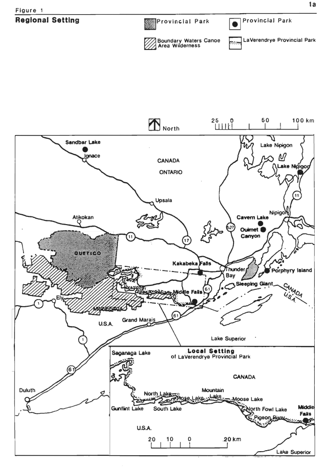
LaVerendrye Provincial Park was established as a waterway class park in 1989, in recognition of its recreational and tourism potential and the significant cultural and natural resources which are associated with the areas. Located southwest of Thunder Bay, along the International boundary between Canada and the United States, the park links Quetico Provincial Park to the west with Middle Falls Provincial Park to the east.
LaVerendrye Provincial Park, along with portions of Quetico and Middle Falls Provincial Parks, have been accepted into the Canadian Heritage River System as the Boundary Waters Voyageur Waterway. This gives national recognition to the areas rich history and the outstanding opportunities the park provides for canoeing, boating, camping, fishing, hiking and a variety of other recreational activities.
We are pleased to approve the LaVerendrye Provincial Park Management Plan, as official policy for the management and development of this park. The Plan reflects this Ministry’s intent to protect the natural and cultural features of LaVerendrye Provincial Park and maintain and develop high quality opportunities for outdoor recreation and heritage appreciation for both residents of Ontario and visitors to the Province.
D. R. Johnston
Regional Director
Northwest Region
N. R. Richards
Director, Provincial Parks and Natural Heritage Policy Branch
1.0 Introduction
LaVerendrye Provincial Park was regulated on May 24, 1989 (O.Reg.2/89). It was selected for Park status in recognition of its recreational and tourism potential and the significant cultural and natural resources which are associated with the area. These include archaeological and historical sites, provincially rare plant species and representative geologic formations. The Park provides representation and protection of a lacustrine (lake deposited) clay plain and diabase dikes (ridges).
LaVerendrye Provincial Park is located on the International Boundary between Canada and the U.S.A., southwest of the City of Thunder Bay. It is adjacent to the Boundary Waters Canoe Area (BWCA) of the United States to the south and extends between Quetico Provincial Park in the west, to Middle Falls Provincial Park in the east. (Figure 1). The Park is 18,335 hectares in size with a water area of 8,404 ha and a land area of 9,931 ha.
The height of land between the Arctic and Atlantic watersheds crosses the park, between North and South lakes. From that point, water flows eastward to the Atlantic Ocean and westward to the Arctic Ocean.
LaVerendrye Provincial Park is recognized to be of major historical significance due to its use by early explorers and voyageurs. Today, the park lies within the premiere wilderness canoeing country of North America. The area is heavily used for recreational and tourism purposes by canoeists, boaters, fishermen, hunters, and cottagers, attracting the majority of its users from the north central United States.
The Park’s location along the International Boundary between Canada and the United States requires the development of management policies with an appreciation of implications to the adjacent land uses of both countries. Since 1970, the area of LaVerendrye Provincial Park has been managed under the terms of the Management Guidelines for the International Boundary Waters (Ontario Department of Lands and Forests, 1970). This plan will take precedence over these Guidelines for the area within LaVerendrye Provincial Park.
Significant issues identified for LaVerendrye Provincial Park include: Canada/United States relations, including the differences in the operations of the Parks on either side of the border; the relations between cottage owners whose property is surrounded by the Park; and the operation of the Park itself.
2.0 Park classification
LaVerendrye Provincial Park is classified as a Waterway Park, one of six classes in the Provincial Parks System. Ontario Provincial Parks Policy gives this definition for waterway parks:
It is in recognition of the Park’s variety of recreational opportunities and representation of earth and life science and cultural features, as well as its traditional patterns of use, that it has been classified as a waterway park.
3.0 Park goal
The goal for LaVerendrye Provincial Park is:
The Park forms part of the Ontario Provincial Parks System as established through the Parks System Planning Program and contributes to the provincial park targets established in the Thunder Bay District Land Use Guidelines, DLUG (OMNR, 1983).
Figure 1: A map of the regional setting of LaVerendrye Provincial Park
4.0 Park objectives
LaVerendrye Provincial Park contributes to the achievement of each of the four established objectives of the Provincial Parks System as follows:
4.1 Protection objective
LaVerendrye Provincial Park contains a variety of biophysical and cultural resources of provincial significance. These include:
- an earth and life science biophysical unit known as the Pigeon River clay plain;
- eleven provincially rare plant species;
- earth science features including representative examples of glacial moraines, the Rove and Gunflint Formations, and north facing cliffs;
- historical and cultural features associated with prehistoric, historic and modem day use of area by aboriginal peoples, fur traders, explorers and recreators.
The Park’s major recreational, cultural and natural resources will be safeguarded through appropriate zoning and management policies. The protection of the natural quality of the Waterway environment is the prime objective, and is vital to the achievement of the other Park objectives.
4.2 Recreation objective
LaVerendrye Provincial Park provides outstanding opportunities for a variety of high quality recreational uses compatible with the natural character of the Park. The main emphasis will be the provision of backcountry travel along the Waterway. Recreation activities associated with the Park include canoeing, boating, fishing, hunting, hiking, snowmobiling and cross-country skiing.
LaVerendrye Provincial Park’s recreational facilities and opportunities will contribute to the achievement of provincial park targets by providing 5,000 of the 14,000 non-wilderness backcountry travel opportunities in the Thunder Bay District by the year 2000.
4.3 Heritage appreciation objective
The opportunity for individual exploration and Interpretive programs will provide park visitors with a greater appreciation for and understanding of the area’s natural and cultural resources. This includes early exploration, the fur trade routes of Canada and the area’s wealth of earth and life science features. The Section under 9.1 Visitor Services list interpretive themes and portrayal techniques for the Park.
4.4 Tourism objective
LaVerendrye Provincial Park will provide its users a greater opportunity to access and utilize the tourism and recreational resources of the area. The Park will provide day use and camping opportunities for Waterway travellers as well as destination camping opportunities for those attracted from considerable distances. Winter use of the Park for cross-country skiing, snowmobiling, camping and fishing provide year round tourism opportunities.
Development within the Park will take into consideration existing and planned tourism development in the area (e.g. lodges on Saganaga, Northern Lights and Arrow Lakes). Park development will complement and strengthen the tourism industry. (Refer to Sections under 10.0.) The Park will provide the opportunity for the development of additional high quality, year-round recreational facilities appropriate to the Park’s natural setting while minimizing impacts on the environment. An example is the potential for commercial accommodation and outfitting, and associated services on Red Sucker Bay of Saganaga Lake. Other examples include the proposed MNR operation of campgrounds and associated facilities at North, Mountain, and North Fowl Lakes. Refer to Sections 10.1 and 10.2 respectively.
5.0 Park boundary
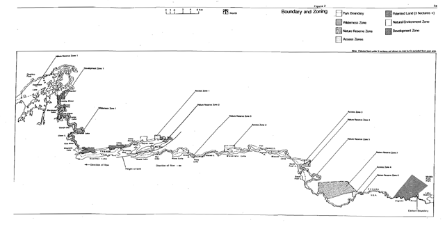
LaVerendrye Provincial Park extends from Quetico Provincial Park in the west along the lakes and rivers of the Pigeon River corridor to Middle Falls Provincial Park in the east. The Park’s southern boundary is the International Border between Ontario, Canada and Minnesota, United States. (Figure 2).
The northern boundary extends 200 metres inland from the shoreline along the majority of the Waterway. The boundary is reduced to 100 metres where this distance is adequate to maintain Park values and a skyline view. The boundary is increased in other areas, to provide access and development zones, to maintain a skyline view and/or incorporate significant natural features.
Areas of boundary reduction occur on Saganaga Lake and two segments on the Pigeon River, involving approximately 19 km of shoreline. Areas of boundary expansion occur on Saganaga Lake, North Lake (3), Arrow River, Mountain Lake (2), North Fowl Lake, and the Pigeon River (3), involving approximately 29 km of shoreline.
All private land is excluded from LaVerendrye Provincial Park.
No privately owned land will be expropriated for Park purposes. Should privately owned land be placed for sale on the market, or offered for sale by the owner, the MNR will consider purchase if acquisition of the property will enhance the achievement of Park objectives. Acquisition of the following areas will be considered:
- a portion of the Stuart location adjacent to the Pigeon River extending 200 metres inland or to Highway 593 (whichever is less), for future potential access to the Waterway (approximately 111 ha);
- mining location X137 and X202 on North Lake (approximately 80 ha) for future potential access to the Waterway;
- mining locations TB29135, TB29134, R205 and R315 on Magnetic Lake (approximately 85 ha) and R311, R313 (TB4587), R319, 291T, 292T, 293T, 297T and 298T on Gunflint Lake (approximately 595 ha) for future potential backcountry campsite locations.
- leased mining claims on the north shore of Saganaga Lake
No land disposition will take place with the following exceptions:
- land in D1 may be leased for the purposes of commercial development that complements park objectives;
- the 66 foot shoreline reserve on patented land adjacent to Magnetic, Gunflint and North Lakes now in the Park, may be disposed of to adjacent landowners if such disposition compliments Park values or enhances Park objectives.
6.0 Park zoning
To provide more specific management direction, the Park has been zoned using five of the six designations described in the Ontario Provincial Parks Planning and Management Policies, 1978. (Figure 2).
Zoning allocates the Park areas on the basis of their significance for protection and their potential for recreation within the context of the Park’s classification.
Figure 2: A boundary and zoning map for LaVerendrye Provincial Park
6.1 Natural environment zone
Natural environment zones include aesthetic sections of the corridor in which there is minimum development required to support low-intensity recreational water travel activities and protect aesthetic landscapes.
Development permitted within this Zone includes backcountry campsites, portages, trails, docking and boat launching facilities, necessary signs for route identification, entry control station (at Gunflint Lake), minimal interpretive facilities (unmanned interpretive stations), and similar simple facilities which will support low-intensity recreational activities.
6.1.1 NE1 (12,945 ha)
The purpose of this Zone is:
- to provide opportunities for recreational activities such as canoeing, boating, hiking, snowmobiling and cross-country skiing, backcountry camping, fishing, hunting and associated day use activities such as picnicking;
- to provide boat docking and launching facilities;
- the protection of natural features such as an exposure of the Gunflint Formation on North Lake and its reference section on Gunflint Lake;
- the protection of archaeological and historic sites;
This Zone contains the majority of the Park’s land and water area and extends throughout the Park’s length.
Existing development within this Zone includes the majority of the Park’s portages and backcountry campsites, a portion of the Pigeon River Hiking Trail,and a snowmobile trail from North Lake to Magnetic Lake which occupies a former railway bed.
6.2 Nature reserve zones
Nature reserve zones protect significant earth and life science features in the corridor which require management distinct from that in adjacent zones. The priority for nature reserve zones is protection and research. Protection is ensured through zoning and appropriate uses of the Park and the enforcement of Park regulations. Nature reserve zones provide quality opportunities for low intensity, resource based activities such as hiking, viewing, photography and nature study. These zones are all land, except for some water in NR2.
Development permitted within these Zones includes trails, necessary signs, minimal interpretive facilities and temporary facilities for research and management. Portages and signs necessary to backcountry travel in the Park will be permitted.
6.2.1 NR1 Seagull Island (3 ha)
The purpose of this Zone is to protect the active heronry situated on Seagull Island.
There is no existing development in this Zone.
6.2.2 NR2 North Lake (24 ha)
The purpose of this Zone is to protect the aquatic flora which is rare and unique to the Park including the provincially significant Juncus subtilis (Creeping Rush).
In addition to the 200 metres of backshore, this Zone extends 200 metres into North Lake. There is no existing development within this Zone.
6.2.3 NR3 Arrow River (134 ha)
The purpose of this Zone is to protect a series of well-developed glacial moraines.
Existing development within this Zone consists of the Long Portage between Rose and Rove Lakes.
6.2.4 NR4 North Fowl Lake (268 ha)
The purpose of this Zone is to protect earth and life science features.
This Zone contains north facing cliffs which offer moist and shady conditions that support rare and unusual plant species. Provincially rare plant species include: Carex supina (Sedge), Oxytropis viscida (Sticky Locoweed), Anica angustifolia (Narrow-leaved Arnica), Phacelia franklinii (Wild Heliotrope), Woodsia scopulina (Rocky Mountain Woodsia), and Calamagrostis purpurascens (Purple Reed Grass). These cliffs also contain a well developed reference section of the Rove Formation.
There is no existing development within this Zone.
6.2.5 NR5 South Fowl Lake (128 ha)
The purpose of this Zone is:
- to protect the north facing cliffs which contain several provincially rare plant species including: Phacelia franklinii. Oxytropis viscida, and Calamagrostis purpurascens, and,
- to protect the bog area northeast of the cliffs which is botanically rich and susceptible to disturbance; and,
- the protection of archaeological sites.
Existing development within this Zone consists of the Fowl Lake Portage between South Fowl Lake and the Pigeon River.
6.2.6 NR6 Cascades (21 ha)
The purpose of this Zone is to protect a variety of disjunct vegetational species including Viburnum lentago (Basswood).
Existing development within this Zone includes a portion of the Pigeon River Hiking Trail.
6.2.7 NR7 Pigeon River Clay Plain (2,733 ha)
The purpose of this Zone is to protect the feature commonly referred to as the Pigeon River Clay Plain.
The Zone provides good representation of a life science biophysiographic unit - lacustrine (lake deposited) clay plain and diabase dikes (ridges) in Site Region 4W, Site District 2 and a variety of associated vegetation communities. Steep rock ridges that surround the majority of the Zone’s perimeter provide good protection to the area and create a natural buffer from outside influences.
Existing development within this Zone consists of a portion of the English Portage on the Pigeon River.
6.3 Development zone
Development zones provide access where appropriate for large numbers to the water route, and facilities and services for a wide range of day use and camping activities where appropriate.
The designation of a development zone is based on the physical capability of the area to sustain relatively intensive forms of recreation and associated facilities and services while maintaining aesthetics.
Development permitted within this Zone includes roads, trails, utilities, visitor and entry control structures, day use facilities, car and boat campgrounds, parking and picnicking facilities, necessary signs, orientation, interpretive, educational, research and management facilities (administrative, maintenance and visitor services), and garbage collection facilities. Basic commercial service facilities permitted include accommodation, outfitting, docking, restaurant and food services and a store for waterway users.
6.3.1 D1 Red Sucker Bay (238 ha)
The purpose of this Zone is;
- to provide access to the waterway corridor;
- to provide facilities and services year round for a wide range of day use and overnight accommodation opportunities;
- to provide for the establishment of commercial facilities (see Section 10.1);
- to provide an alternative form of year round overnight accommodation within the Park; and,
- to attract a broader range of clientele to the Park.
Development in the southern portion of this Zone will be minimal as to minimize impacts on the adjacent wilderness zone.
Existing development within this Zone includes a backcountry campsite and the portage around Saganaga Falls.
This Zone will serve as the Park’s administrative and operational base and will contain the majority of facilities and services for recreational opportunities including the main campground and day use area.
6.4 Access zones
Access zones provide access to the waterway corridor and serve as staging areas where minimum facilities support use of less developed portions of the water route.
Development permitted within these Zones may include roads, visitor and entry control structures, car campgrounds, parking facilities, boat launching facilities (except A4), and orientation, interpretive, educational, research and management facilities (administration, maintenance, and visitor services), garbage collection facilities and basic commercial service facilities for visitors including outfitting services.
6.4.1 A1 North Lake (99 ha)
The purpose of this Zone is:
- to provide for future potential access to the waterway corridor;
- to provide for future potential recreational facilities and opportunities for Waterway users (e.g. car campground and parking facilities and boat launching ramps);
- to provide garbage collection facilities for Waterway users,
- to provide the opportunity for informational and interpretive display exhibits; and,
- to provide for visitor and entry control stations.
Existing development within this Zone, includes a snowmobile trail which occupies a former railway bed.
6.4.2 A2 Mountain Lake (180 ha)
The purpose of this Zone is:
- to provide access to the waterway corridor;
- to provide car and boat camping opportunities adjacent to the Waterway;
- to provide for the future potential expansion of the existing campground and associated recreational facilities (e.g. parking and boat launching);
- to provide garbage collection facilities for Waterway users;
- to provide the opportunity for informational and interpretive display exhibits; and,
- to provide for visitor and entry control stations.
Existing development within this Zone includes a forest access road and an access point with associated camping.
6.4.3 A3 North Fowl Lake (64 ha)
The purpose of this Zone is:
- to provide access to the Waterway corridor;
- to provide car and boat camping opportunities adjacent to the Waterway;
- to provide for future potential expansion of the existing campground and associated recreational facilities (e.g. parking and boat launching);
- to provide garbage collection facilities for Waterway users;
- to provide the opportunity for informal and interpretive display exhibits; and,
- to provide for visitor and entry control structures.
Existing development within this Zone includes a road and an access point with associated camping.
6.4.4 A4 Cascades (198 ha)
The purpose of this Zone is:
- to provide for future potential access to the Waterway corridor via a portage trail for nonmotorized boats only;
- to provide for future potential recreational facilities and opportunities for Waterway users (e.g. day use facilities only i.e. parking and picnicking facilities);
- to provide garbage collection facilities for Waterway users;
- to provide the opportunity for informational and interpretive display exhibits; and,
- to provide for visitor and entry control stations.
Existing developments include: road access for forestry purposes only, through the northwest comer of this Zone and a portion of the Pigeon River Hiking Trail. No other development exists.
6.5 Wilderness zone
Wilderness zones include associated wilderness landscapes of appropriate size and integrity which protect significant natural and cultural features and are suitable for wilderness experiences.
Development permitted within this Zone includes: designated backcountry campsites, portages, trails and necessary signs for route identification.
6.5.1 W1 Pine River (1300 ha)
The purpose of this Zone is:
- to provide an area where the forces of nature are allowed to function freely;
- to provide high quality backcountry wilderness recreation opportunities such as canoeing and camping; and,
- the protection of archaeological sites.
Existing development within this Zone consists of backcountry campsites and portages.
7.0 Canadian heritage river system
The Boundary Waters Voyageur Waterway was nominated by the Ministry of Natural Resources as a Canadian Heritage River and accepted by the Heritage Rivers Board in June 1986. This Waterway is comprised of the Boundary Waters portion of Quetico Provincial Park, LaVerendrye Provincial Park in its entirety (excluding NR7), and the southern portion of Middle Falls Provincial Park Upon completion of this Plan this area will be designated as a Heritage River.
The Canadian Heritage Rivers System is a cooperative program, developed and run by the parks administrations of territorial, provincial and the federal governments to give national recognition to the important rivers of Canada.
The primary objective of the program is to ensure that rivers which are outstanding examples of Canada’s natural heritage, which have played a significant role in Canadian history, or which offer outstanding opportunities for recreation, are managed in such a way that their distinctive heritage values are conserved while their potential for future public use and enjoyment is enhanced.
8.0 Resource management policies
Resource management of LaVerendrye Provincial Park will be guided by the Ontario Provincial Parks Planning and Management Guidelines. It will emphasize the overall goal and objectives of the Park and concentrate on protection and heritage appreciation of the Park’s biophysical and cultural resources while permitting recreation and tourism. Resource protection will vary according to zone designation.
A Park Operations Strategy will be prepared in keeping with the direction provided in the Management Plan. The Operations Strategy will provide specific operational guidelines for carrying out the management of the Park’s water, land, natural and cultural resources.
Commercial removal of natural resources from the Park is prohibited except for bait fishing in the Natural Environment Zone.
Status Indians enjoying treaty rights to carry out traditional natural resource harvesting activities shall be permitted to carry on those activities in accordance with the terms of their treaty within their treaty areas.
8.1 Water management
Water management within LaVerendrye Provincial Park will maintain water quality for fisheries habitat and recreational purposes. Water quality will be monitored on a regular basis adjacent to the development and access zones where camping occurs in accordance with Provincial health standards, once the park is operational.
Park waters, located on the International Boundary, are under the jurisdiction of the International Joint Commission (IJC) of the United States and Canada. The Commission has jurisdiction over all matters involving the use, diversion, or obstruction of the boundary waters. The Ministry of Natural Resources will work in conjunction with the IJC and Canadian and American Government agencies to ensure water quality and control along the International Boundary Waters and within LaVerendrye Provincial Park.
The water levels within LaVerendrye Provincial Park are presently not controlled except on the Fowl Lakes. The unmaintained dam at the outlet of South Fowl Lake controls the water levels at approximately one metre above natural lake levels. The present condition of the dam structure does not allow for the adjustment of water levels.
- Any improvement, alternation, or removal of the dam would require negotiation and agreement through the International Joint Commission. The intention within LaVerendrye Provincial Park is to maintain the existing water levels on North and South Fowl Lakes, and to negotiate and implement any measures required to ensure this.
A South Fowl Lake Dam Strategy will be prepared:
- to identify the agencies involved and their interrelationships in the operation and maintenance of the South Fowl Lake Dam;
- to identify the procedures for the maintenance and/or replacement of the South Fowl Lake Dam; and,
- to identify the recommended water level for North and South Fowl Lakes (in metres above sea level) and the method(s) for monitoring the Lakes’ water levels.
MNR does not endorse water level controls elsewhere in the Park and will recommend to the IJC that they adopt this policy.
8.2 Vegetation management
The management of vegetation within the Park will be conducted in a manner which will allow the natural succession of communities, recognizing that the control of insect, disease and fire may take precedence. The activities described below will be undertaken with this objective in mind.
Commercial forestry operations are prohibited within LaVerendrye Provincial Park.
The removal of safety hazards in the Park such as danger trees (dead and diseased trees) on trails, portages and at designated campsites, will be permitted in all zones. Areas experiencing adverse use impacts may be rehabilitated using plant and tree species native to the park only. Landscaping will be minimal and will be permitted in the development and access zones, and on severely damaged backcountry campsites in NE1 only.
Vegetation may be removed for development of structures and facilities which are consistent with this Management Plan and any plans prepared in support of it. The biological features of a site will be inventoried before carrying out work to avoid negative impacts on significant sites or species. Trees which are removed may be used for Park purposes such as firewood.
The control and suppression of insects and diseases is permitted throughout LaVerendrye Provincial Park where they pose a threat to Park values (as determined by the Park Superintendent) or values external to the Park (as determined by the District Manager).
Where control is necessary, it will be directly applied to the specific targeted insect or disease so as to have minimal effects on other components of the Park’s environment. Biological and physical controls will be used wherever feasible.
The cutting of dead trees by backcountry campers and day users for the purpose of campfires is permitted. The cutting of dead trees for the purpose of heating and cooking by cottagers and residents adjacent to the Park is prohibited within the Park, except where allowed by permit. Property owners on Saganaga and Gunflint Lakes may cut dead trees for such purposes only under the authority of a Ministry of Natural Resources fuelwood permit.
The harvesting of wild rice in the Park is prohibited except by Natives enjoying Treaty Rights.
8.3 Fire management
All wild fires will be suppressed within LaVerendrye Provincial Park. The detection and suppression of wild fires will be carried out to ensure the safety of visitors and other individuals in the vicinity of the Park, to protect facilities in and adjacent to the Park and to protect significant resource values within the Park. Fire suppression techniques will be used which have as minimal effect as possible on the Park environment. Bulldozing and water bombing with chemical additives will not be permitted, except in critical situations as determined by the Park Superintendent.
8.4 Wildlife management
Wildlife management within the Park will be compatible with the management of areas adjacent to the park, and with Park policies and regulations.
Hunting is allowed in NE1 only. The Park Superintendent may restrict hunting at certain times and locations for safety purposes.
Fur trapping is prohibited in all Nature Reserve Zones. Fur trapping by non-natives within the remainder of the Park will be phased out by January 1, 2010 or when the trapper retires or dies, whichever is sooner. At that time, those portions of the licence within the Park will be removed. Where a trapper licence lapses, the licence will not be renewed. No new licences will be issued. Upon the sale or transfer of any trapline within the Park from its present owner, the portion within the Park will be removed from the trapline. All trapping within the Park will cease by January 1, 2010.
Nuisance animals will be controlled under the strict supervision of, or directly by the MNR in LaVerendrye Provincial Park. Such control will be exercised when it is essential for the protection of human health and safety, Park values, or the health of animal species. The techniques which are used, such as trapping, relocation or shooting as a last resort, will have minimal detrimental effects on other components of the Park’s environment.
8.5 Fisheries management
Fisheries management in LaVerendrye Provincial Park will be done in accordance with the Thunder Bay District Fisheries Management Plan [DFMP] (OMNR, 1989). The DFMP identifies the need for a specific Fisheries Management Plan for the area of LaVerendrye Provincial Park.
Sport fishing is permitted throughout the Park. All fishing activity in LaVerendrye Park will adhere to the policies and regulations of Division 21 of the Ontario Fishing Regulations. The Park Superintendent may restrict sport fishing at certain times and locations for the purposes of fisheries management and/or public safety.
Attempts will be made to negotiate common fisheries regulations such as length of season and catch limits with the State of Minnesota for the waters within the Park. Should these negotiations result in changes to the Ontario Fisheries Regulations for Division 21 the Regulations will be revised prior to implementation within LaVerendrye Provincial Park.
Stocking and spawn collection by permit are permitted throughout the Park.
The use of live bait for the purpose of fishing is permitted throughout the Park.
Commercial bait fishing is permitted in NE1.
Commercial fishing is prohibited within LaVerendrye Provincial Park.
8.6 Landform management
The management of the land base of LaVerendrye Provincial Park will be directed towards the maintenance of the natural landscape and waterway environment while permitting limited resource utilization to meet Park needs.
Mineral exploration and mining are prohibited within LaVerendrye Provincial Park.
Erosion control work to protect Park values and public safety is permitted in the access and development zones and at designated backcountry campsites in NE1 only. The application of non-structural techniques is preferred where possible.
The establishment of roads and utilities by private enterprise or by the MNR will be directed by approved Site Plans. Such projects will be permitted in the access and development zones of the Park only and progress will be closely monitored.
Waste disposal sites and dumping are prohibited within the Park. Garbage collection facilities will be located in the access and development zones only. Park user solid waste and sewage will be disposed of outside of the Park through local facilities or in an established area. Existing unauthorized waste disposal sites will be cleaned up (i.e. Saganaga Lake sites).
Road, rail and utility line crossing of the Park are prohibited.
Where possible, aggregate for in-park-purposes will be imported from sources outside provincial parks and numbers of pots will be limited to only those necessary for essential in-park-purposes. The size and distribution of pits will be limited by the need to protect park values and sound environmental planning principles. Aggregate will be removed from the park only as a last resort and after an Aggregate Plan has been prepared:
- to conduct an aggregate inventory and identify locations, types and amounts of materials available within the access and development zones.
- to ensure efficient use of these materials within the Park for development and maintenance purposes; and,
- to describe how all gravel pits will be rehabilitated to the standards described in the regulations of the Aggregate Resources Act.
Upon completion of the Aggregate Plan, gravel extraction is permitted in the access and development zones for Park maintenance and/or development purposes only. There will be no removal of mineral aggregate from the Park.
8.7 Cultural resources management
The management of cultural resources will be directed to protection, heritage appreciation and research. Protection of archaeological and historical sites within the Park will be achieved through zoning and by limiting the type and amounts of recreational activities and development that occur in these areas. Designated campsites will be established to segregate today’s users from the prehistoric and historic sites.
The Ministry of Natural Resources will continue to work in conjunction with Ministry of Culture and Communications in the inventory, protection and maintenance of archaeological and historic sites along the Waterway corridor. If deemed appropriate and necessary for the protection and preservation of cultural resources, such inventory may include excavations of archaeological sites. Excavations by authorized licensed personnel with the appropriate research permits will be conducted under the approval and supervision of the above named Ministries. Upon completion of excavation, the site or portions of the site will be returned to their original condition, or will be developed for the purposes of interpreting the cultural resources inherent in the sites. The type and extent of such development will be determined by the findings from the excavation.
Periodic inspections of significant sites will occur with protective controls established as required. The removal of artifacts or destruction of historical features is illegal.
Where cultural resources occur on private land along the Waterway corridor, the Ministry of Natural Resources will work with landowners to encourage and assist them in protecting and caring for the features on their property.
9.0 Operations policies
Operations will only occur subject to funds being available.
Park operations will be managed in accordance with the Park Management Plan and the Park Operating Plan. The Operating Plan will provide Park staff with the necessary information required to operate the Park on a day-to-day basis. In addition to addressing the operations policies which follow, the Operating Plan will include such topics as budget, staffing, maintenance schedules, enforcement and emergency services. The provisions of the Operating Plan will be consistent with the approved Ontario Provincial Parks Operating Standards, and will be reviewed annually and updated as required.
Maintenance of interior campsites and portages will be undertaken. The level of maintenance will be determined by the amount of available funding.
The MNR will encourage through partnerships with the private sector or volunteers, the provision of Park services. All private sector services considered will be consistent with the policies of this Plan.
A Sign Plan will be prepared for LaVerendrye Provincial Park which will detail the location and types of interpretive and directional signs as well as strategies for sign development and placement.
9.1 Visitor services
LaVerendrye Park will offer a basic level visitor services program. The primary objective will be to orient Park visitors to the natural and recreational attributes of the Park.
A Visitor Services Plan will be prepared and will provide details regarding the visitor services program and facilities for LaVerendrye Provincial Park.
LaVerendrye Provincial Park’s visitor services will emphasize use by locals, destination campers and users who are passing through the area. It will be oriented to Park visitors of all ages and a variety of interests such as backcountry users, facility based campers and day users. Self-use approaches, such as publications and display panels will be used to deliver Park information, resource interpretation, recreational skills and Park management messages.
9.1.1 Park information
A public information program will be established which will provide visitors with information about the Park and its resources, environment and facilities. Information will emphasize the visitor’s role in maintaining the natural environment of the Park and appropriate behaviour in parks, safety in the outdoors, nuisance animals and travel along the Waterway. Park literature will also advise visitors of commercial services and attractions in the local area and other provincial parks.
A Park map and informational package will be produced to enable users to safely explore and use the Waterway. Information will be provided that will direct campers away from heavily-used areas. Low impact camping at dispersed sites will be encouraged. A leave no trace attitude will be promoted in order to minimize human impact on the Park environment. The importance of respecting other users will be stressed, particularly the rights of private property owners. This information will initially be available at the MNR Regional Office in Thunder Bay and upon completion of development, at static informational and interpretive displays in the access and development zones, and through the Park Office and commercial facilities.
9.1.2 Interpretation
Interpretive programs and facilities will provide Park visitors with a greater appreciation for and understanding of the natural and cultural features of LaVerendrye Provincial Park. Printed material, self-use facilities and informal personal contact will be the primary means of interpretation.
The Park’s main interpretive theme relates to its historical and cultural significance, which has included Prehistoric Occupation, Early European Exploration, the Fur Trade, and the Railroad and Logging Era. The Park also offers the potential for interpretation of four minor themes: Geology and Landscape, Vegetation, Wildlife Viewing and International Relations.
Innovative ways of co-operative portrayal of these themes will be pursued with other agencies and business interests. Historic portages will receive priority as they provide physical evidence of the presence of man in the area.
9.1.3 Recreation
Basic recreation information provided on the park map will acquaint Park visitors with the recreational attributes of the Park and the skills required for minimum impact Waterway travel.
9.2 Recreation management
Recreation management within LaVerendrye Provincial Park will optimize the opportunities for recreation and minimize impacts on the environment and on adjacent private property.
Recreation management within the Park will be directed towards the provision of a variety of backcountry travel opportunities along the Waterway such as canoeing, kayaking, boating, hiking, cross-country skiing, snowshoeing and snowmobiling. Activities associated with these include: camping, angling, hunting, picnicking, swimming, and scenic and wildlife viewing opportunities.
Recreational activities that are incompatible with the Park goal or zones are prohibited or restricted. The occurrence of these activities will be prevented through public education of Park visitors concerning appropriate uses in parks and through the establishment of zones and the identification and enforcement of permitted uses. (Table 1).
An emphasis of the recreation management program will be to disperse recreation activities throughout the Park. This will be achieved through the development of appropriately spaced access areas throughout the length of the Park.
Backcountry camping is permitted within LaVerendrye Provincial Park at designated campsites only. These will be identified by the presence of a sign and will be located in the NE1 and in W1 only. Those campsites which are deemed inappropriate may be subject to campsite closure or campsite rehabilitation. From time to time the location of these designated campsites may be changed to prevent overuse of the sites. Attempts will be made to segregate modem-day campsites from sites of archeological significance to ensure the protection of the cultural resources.
A party size limit of 9 individuals per designated backcountry campsite has been established for LaVerendrye Provincial Park (NE1 and W1). No entry quotas presently exist for the Waterway.
While the concentration of recreation activities will be controlled through the designation of campsites and the imposition of a party size limit, higher concentrations will be allowed in designated access and development zones.
Car camping is permitted at A2 and A3 and may be established in A1 and D1 as demand warrants. Picnicking is permitted throughout the Park.
The use of motorboats is permitted within LaVerendrye Provincial Park (without horsepower limitations) except in W1 and NR2. Boat caches are prohibited within LaVerendrye Provincial Park.
Snowmobiles are permitted in LaVerendrye Provincial Park except in W1 and in Nature Reserve Zones 1-7 (except by permit use by trappers, and MNR staff for Park purposes).
Motorized all-terrain vehicles and off road dirt bikes are permitted in designated areas of the access and development zones only. Equestrian trails may be designated in the access, development and natural environment zones.
The use of non-burnable food and beverage containers (cans and bottles) are prohibited in W1. The possession of cans and bottles in all other areas of the Park is permitted, but their disposal will be allowed only at designated locations in the access and development zones.
The landing of aircraft is permitted throughout the Park (except in W1) with an MNR aircraft landing permit. A landing permit will not be required on Saganaga Lake for the purposes of clearing Canada Customs.
The Pigeon River Hiking Trail will be realigned to be entirely within LaVerendrye Provincial Park boundaries.
Recreational structures are prohibited in the nature reserve zones.
In order to maintain the natural character of the Park, recreation management activities will be monitored. Management techniques such as capacity standards, entry quotas and the implementation of new or revised restrictions on certain activities may be established if necessary, to maintain the natural and recreational quality of the Park for visitors.
9.3 Tourism services
LaVerendrye Provincial Park offers excellent potential for future tourism development due to its significant resource features. The level of services provided will be based on public demand and the ability of the environment to sustain such activity. Development will be compatible with the physical setting of the Park and will not take place where similar facilities and services are available nearby. Existing Park facilities and services will be upgraded and enhanced as funding permits.
Table 1: Permitted uses by park zones
Resources uses permitted
| Development zone | NE1 | NR1 | NR2 | NR3 | NR4 | NRS | NR6 | NR7 | D1 | W1 | A1 | A2 | A3 | A4 |
|---|---|---|---|---|---|---|---|---|---|---|---|---|---|---|
| Commercial Bait Fishing | Y | n/a | N | n/a | n/a | n/a | n/a | n/a | n/a | N | n/a | n/a | n/a | n/a |
| Fuelwood Cutting by Permit | Y1 | N | N | N | N | N | N | N | N | N | N | N | N | N |
| Trapping | Y2 | N | N | N | N | N | N | N | Y2 | Y2 | Y2 | Y2 | Y2 | Y2 |
Recreational uses permitted
| Development zone | NE1 | NR1 | NR2 | NR3 | NR4 | NRS | NR6 | NR7 | D1 | W1 | A1 | A2 | A3 | A4 |
|---|---|---|---|---|---|---|---|---|---|---|---|---|---|---|
| Canoeing/Kayaking | Y | n/a | n/a | n/a | n/a | n/a | n/a | n/a | n/a | Y | n/a | n/a | n/a | n/a |
| Camping - Car | N | N | N | N | N | N | N | N | Y | N | Y | Y | Y | N |
| Camping - Designated Backcountry | Y3 | N | N | N | N | N | N | N | n/a | Y3 | n/a | n/a | n/a | n/a |
| Camping - Group | Y | N | N | N | N | N | N | N | Y | N | Y | Y | Y | N |
| Cross Country Skiing | Y | Y | Y | Y | Y | Y | Y | Y | Y | Y | Y | Y | Y | Y |
| Cycling | N | N | N | N | N | N | N | N | Y | N | Y | Y | Y | Y |
| Hiking/Backpacking | Y | Y | Y | Y | Y | Y | Y | Y | Y | Y | Y | Y | Y | Y |
| Horseback Riding | Y4 | N | N | N | N | N | N | N | Y4 | N | Y4 | Y4 | Y4 | Y4 |
| Hunting | Y | N | N | N | N | N | N | N | N | N | N | N | N | N |
| Motor Boating | Y | n/a | n/a | n/a | n/a | n/a | n/a | n/a | n/a | N | n/a | n/a | n/a | n/a |
| Motorized All-Terrain Vehicles* | Y4 | N | N | N | N | N | N | N | Y4 | N | Y4 | Y4 | Y4 | Y4 |
| Picnicking | Y | Y | Y | Y | Y | Y | Y | Y | Y | Y | Y | Y | Y | Y |
| Sailing | Y | n/a | N | n/a | n/a | n/a | n/a | n/a | n/a | Y | n/a | n/a | n/a | n/a |
| Scuba and Skin Diving | Y | n/a | N | n/a | n/a | n/a | n/a | n/a | n/a | Y | n/a | n/a | n/a | n/a |
| Snowmobiling | Y4 | N | N | N | N | N | N | N | Y4 | N | Y4 | Y4 | Y4 | Y4 |
| Snowshoeing | Y | Y | Y | Y | Y | Y | Y | Y | Y | Y | Y | Y | Y | Y |
| Sport Fishing | Y | n/a | N | n/a | n/a | n/a | n/a | n/a | n/a | Y | n/a | n/a | n/a | n/a |
| Swimming | Y | n/a | N | n/a | n/a | n/a | n/a | n/a | n/a | Y | n/a | n/a | n/a | n/a |
*Includes off-road dirt bikes.
Note: Activities not in this list are prohibited within the Park. Traditional resource activities by Status Indians exercising Treaty Rights are permitted within the Park.
The development of commercial facilities will be permitted in D1 only. The Park Operating Plan will detail the location, type and extent of commercial development within this Zone. It will also provide specifications and guidelines for the tendering of detailed proposals for private development. The level of development in D1 will be limited by the ability of Saganaga Lake to sustain development without damaging water quality. MNR will consult with the Ministry of the Environment to determine appropriate level of development.
Private land adjacent to the Park offers excellent potential for commercial development and will be encouraged, provided that it does not jeopardize Park values and/or Park resources.
The operation of MNR facilities in the access zones by private interests is permitted.
9.4 Marketing
A Marketing Plan will be developed for LaVerendrye Provincial Park in accordance with established Ministry policy and procedures. It will be reviewed annually and revised as required. Marketing activities will be consistent with the Regional Marketing Plan.
The objectives of the Marketing Plan are:
- to capitalize on the natural and cultural features of LaVerendrye Provincial Park to provide a unique outdoor experience within the context of the Park’s classification and goal.
- to encourage Park visitation and the use of commercial facilities by Park visitors;
- to encourage Park use and visitation to low use areas of the Park;
- to work co-operatively with commercial establishments marketing the Park and their services; and
- to encourage year round use of the Park.
9.5 Research
Scientific research by qualified individuals which contributes to knowledge, inventory and identification of natural and cultural resources and to environmental and recreational management will be encouraged in the Park. Subjects of particular resource interest are archeological surveys and inventories of the rare plant species on the north facing bluffs on North Fowl and South Fowl Lakes. A list of potential research topics is available for viewing at the Regional Parks Office in Thunder Bay.
User surveys will be undertaken to determine patterns and extent of Park use, and provided background information necessary to develop strategies to better distribute use throughout the Park.
All research programs must be compatible with the Park’s goal, objectives and zoning prescriptions. They must receive prior approval and be conducted in accordance with MNR policy concerning research in provincial parks. Research must also meet all other applicable Provincial and Federal Government requirements and will be monitored by Regional Parks. Any archaeological research will also require approval and monitoring by Ministry of Culture and Communications. Should provincially or nationally significant features/resources be found, the Plan may be amended to ensure that protection will be provided through appropriate zoning or revision of Plan policies.
10.0 Development policies
Development will be implemented through work program planning based on priority, and subject to the availability of funds. All development will be carried out in accordance with approved site and development plans which detail the location, type and extent of development permitted. Commercial development by the private sector will be guided by specifications prepared by Regional Parks in consultation with Ministry of Tourism and Recreation. Once the development is in place, it will be managed in accordance with the Park Operations Strategy.
Where necessary during the planning stage of development within the Park, MNR will work in conjunction with the Ministry of Culture and Communications to conduct archaeological site assessments in the area of the proposed development. Should sites be known or discovered to exist in that area, opportunities for inventory of the site(s) will be provided. The maintenance and protection of such sites will be directed by research findings. Modifications to the planned development may be considered dependent upon the significance of the archaeological site.
Additional roads and utilities (e.g. hydro, telephone) will be permitted in access and development zones only and construction will be closely monitored by MNR. The upgrading, construction and maintenance of Park roads in the access and development zones will be conducted on a continuing basis as required to implement this Plan.
Development in the W1 and Nature Reserve Zones 1-7 will be minimal. No development will take place within the Nature Reserve zones, except necessary signs and trails.
Interpretive, informational and directional signs will be installed at appropriate locations throughout the Waterway as determined by the Park’s Sign Plan.
Refer to Figure 3, Existing and Potential Park Development, and to Table 2 for Permitted Development by Zone.
Figure 3: Existing and potential park development for LaVerendrye Provincial Park
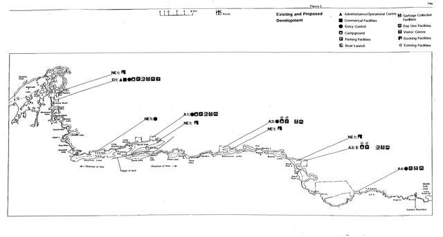
10.1 D1 Red Sucker Bay
Developments within LaVerendrye Provincial Park will be concentrated in this Zone. D1 will serve as the Park’s administrative and operational headquarters and will contain facilities to accommodate these needs such as the Park Office and administrative buildings, maintenance buildings, staff residences, garbage collection facilities, visitor and entry control structures and interpretive and informational displays.
This Zone also provides the opportunity for the development of commercial facilities by the private sector through agreements with MNR, dependent upon recreational demand and the level of interest expressed by private entrepreneurs.
MNR must approve all facilities and services that will be offered here. These recreational and service facilities may include a lodge, cabins, campground, boat launch, docking facilities, outfitting facilities, food services, rental and retail sales services. The commercial operator will be required to provide garbage collection and disposal facilities for Saganaga Lake in D1.
10.2 Access zones
The MNR will enhance and expand existing campgrounds in A2 and A3 and develop new campgrounds in A1. Access Zone 4 will receive less development than the other three access zones and will contain day use facilities only. The access zones will be developed as demand warrants.
Boat launching facilities may be developed in A1, A2 and A3 only. Development to allow motorboat access to the Pigeon River in A4 is prohibited. Development in A4 will include parking facilities, viewing facilities, picnic tables and shelters, and privies.
The Park’s access zones provide potential for future development of roads and recreational facilities, as demand warrants. The present level of development and maintenance will remain until that time.
Facilities to accommodate Park administration and maintenance in these Zones will include visitor and entry control structures, maintenance buildings, garbage collection facilities, staff quarters, informational and interpretive display exhibits and will be developed as demand warrants.
10.3 NE1
Development within this Zone will remain minimal and will include the establishment of designated existing and new campsites by a sign. New backcountry campsites will be developed in areas where existing campsites are insufficient to accommodate the recreational capacity of the area. Some existing campsites may be closed for rehabilitation or for the protection of natural resources. The provision of fireplace grills and primitive privies at designated campsites will be established as demand warrants and funding permits.
Portage upgrading and maintenance, and route identification will be provided dependent upon funding. The use of volunteers and partnerships will be explored.
The establishment of docking facilities adjacent to access and development zones will occur as demand warrants. The docking facilities adjacent to D1 may be developed in conjunction with commercial developments within that Zone.
Table 2: Permitted developments by zone
| Development zone | NE1 | NR1 | NR2 | NR3 | NR4 | NR5 | NR6 | NR7 | D1 | W1 | A1 | A2 | A3 | A4 |
|---|---|---|---|---|---|---|---|---|---|---|---|---|---|---|
| Campground - Car | N | N | N | N | N | N | N | N | Y | N | Y | Y | Y | N |
| Campground - Backcountry | Y | N | N | N | N | N | N | N | N | Y | N | N | N | N |
| Day Use Facilities/Parking | N | N | N | N | N | N | N | N | Y | N | Y | Y | Y | Y |
| Entry Control Facilities | Yes1 | N | N | N | N | N | N | N | Y | N | Y | Y | Y | Y |
| Maintenance & Staff Facilities | N | N | N | N | N | N | N | N | Y | N | Y | Y | Y | Y |
| Commercial Tourism Facilities | N | N | N | N | N | N | N | N | Y | N | N | N | N | N |
| Hiking/Backpacking/X-Country Trails | Y | N | Y | Y | Y | Y | Y | Y | Y | Y | Y | Y | Y | Y |
| Snowmobile Trails (Designated) Y | N | N | N | N | N | N | N | Y | N | Y | Y | Y | Y | |
| Equestrian Trails (Designated) | Yes2 | N | Yes2 | N | N | N | N | Yes2 | Yes2 | N | Yes2 | Yes2 | Yes2 | |
| Portages | Y | N | N | Y | N | Y | N | Y | Y | Y | N | N | Y | Y |
| Roads Utility Lines | N | N | N | N | N | N | N | N | Y | N | Y | Y | Y | Y |
| Directional & Interpretive Signage | Y | Y | Y | Y | Y | Y | Y | Y | Y | Y | Y | Y | Y | Y |
| Interpretive Structures | Y | Y | Y | Y | Y | Y | Y | Y | Y | N | Y | Y | Y | Y |
| Docks Boathouses | Y | N | N | N | N | N | N | N | Y | Y | Y | Y | Y | N |
| Boat Launching Facilities | Y | N | N | N | N | N | N | N | Y | N | Y | Y | Y | N |
| Garbage Collection Facilities | N | N | N | N | N | N | N | N | Y | N | Y | Y | Y |
1Development Permitted at Gunflint Lake Only
2Development Permitted in Designated Areas Only
Existing docks associated with private cottage property adjacent to the Park will be permitted to remain. If new or replacement docks are constructed, there shall be no more than one dock per parcel of land which will not exceed the size of dock being replaced or 50 linealfeet, whichever is greater. Existing boathouses will be permitted to remain and may be replaced by a similar structure. New boathouses or any other new structure will not be permitted in this zone, except in areas adjacent to private commercial property where the Superintendent may approve structures which do not compromise Park values.
The construction or upgrading of any structure within the Park must receive written approval from the Park Superintendent before work begins.
The Pigeon River Hiking Trail will be re-aligned to be entirely within LaVerendyre Provincial Park, the majority of which will fall within NE1. The development of other recreational trails, for nonmechanized uses, will take place as demand warrants.
A visitor and entry control station will be developed on Park land on Gunflint Lake within NE1 if a suitable location on private land cannot be negotiated.
11.0 Plan implementation and review
The management plan will be implemented through work program planning and is subject to the availability of funding. All development, operations and activities undertaken within the Park will comply with the Environmental Assessment Act.
11.1 Implementation priorities
The implementation of developments and improvements in the Park will be in accordance with the phases as described in order of priority, in Table 3. Each phase deals with the preparation and implementation of various plans and site and development concepts. The phases are not intended to be mutually exclusive. Work described in a subsequent phase may be initiated before work in a preceding phase is completed. Preferably, however, it would not be started until work in the preceding phase is well underway.
Special sources for funding the development of facilities will be investigated and utilized as fully as possible.
Recreation management regulations regarding party size limit, can and bottle ban, motor restriction and boat caching will become effective upon approval of this plan and the establishment of the necessary regulations under the Provincial Parks Act. Upon completion of a program to designate interior campsites, the designated campsite restriction will be implemented.
Upon completion of the development of facilities for fee collection and permit issuing, camping and day use fees will be charged.
11.2 Plan review and amendment
The LaVerendrye Provincial Park Management Plan will be reviewed throughout its 20 year lifespan where warranted to address issues or changing conditions. A mandatory review is scheduled to occur after ten years. The review will be conducted in the following manner:
- review of background information and data about the Park resources and use
- review the status of implementation of the approved Management Plan and provincial policies
- identify MNR, other agencies and public issues of concern
- prepare and present issues and suggested solutions for public review and comment;
- review proposed revisions recommended by the public; and
- prepare and receive approval for Plan amendment.
A variety of ongoing monitoring programs will provide essential information concerning the implementation of the Management Plan and the effectiveness of the approved policies. Such mechanisms as the collection of user statistics, periodic user surveys and Park management audits will provide valuable information and feedback to ensure that policies remain current and relevant. Research findings and resource inventory work may aid in conducting Plan reviews.
Table 3: Implementation priorities
| Phase | Resource management plans | Developments |
|---|---|---|
| Phase 1 |
|
|
| Phase 2 |
|
|
| Phase 3 |
|
|
| Other |
|
N/A |
note:
Phase 1: Completion of Phase 1 will ensure the protection of Park values and prepare plans for development.
Phase 2: Completion of Phase 2 will establish a base of public recreation facilities for the Park.
Phase 3: Completion of Phase 3 will establish a support base for Park administration and operations.
12.0 Summary of public consultation
Meetings and information centres with display exhibits were conducted throughout the process to present the issues and ideas pertinent to this Plan to the public and solicit their input. Meetings with specific interest groups were also held and are included in the following list:
Background information and planning options;
- Saganaga, Ontario, Association of Resort and Property Owners on July 30, 1984
- Airlane Motor Hotel on September 18, 1985
Preliminary Management Plan;
- Saganaga, Ontario, Association of Resort and Property Owners on August 30, 1986
- Lakehead Labour Centre on October 1, 1986
Based on public input to the LaVerendrye Provincial Park Background Information and Planning Options stage the following management proposals were included:
- The proposal to include a wilderness zone between Saganaga and Magnetic Lakes. Refer to Section 6.5.1.
Public review of the Preliminary Management Plan endorsed this proposal.
- December 1991: Outline of proposed changes to the Preliminary Management Plan mailed to everyone who had participated in previous public reviews. The opportunity was provided for comment. No substantial changes resulted from this review.
Summaries of the public input received during the planning process are on file in the Thunder Bay Regional Office and are available for viewing.
Selected references
Brunton, D.F. 1987. A Reconnaissance Life Science Inventory of LaVerendrye Waterway Provincial Park Thunder Bay District Ontario. Environment Canada - Parks, Hull, Quebec and Parks Branch, Thunder Bay District, Ontario Ministry of Natural Resources, Thunder Bay, Ontario. 115 pp.
Kor, P. 1975. Brief Geology and Geomorphology of the Access Areas to LaVerendrye Wild River Park Reserve. Environmental Planning Series V. VI, no. 7, Ontario Ministry of Natural Resources. Unedited report.
Noble, T.W. 1975. A Vegetational Survey of the Access Areas to LaVerendrye Wild River Park Reserve. Environmental Planning Series, VI, 8, Ontario Ministry of Natural Resources, Division of Parks, North Central Region, Thunder Bay. 121 pp.
Noble, T.W. 1979. Life Science Report Phase II Site Region 4W, North Central Region. Ontario Ministry of Natural Resources.
Ontario Ministry of Natural Resources. 1987. Area Plan for Fire Management North Central Region.
Ontario Ministry of Natural Resources. 1987. Provincial Park Management Planning Reference. Parks and Recreational Areas Branch. 40 pp.
Ontario Ministry of Natural Resources. 1978. Ontario Provincial Parks Planning and Management Policies. Toronto.
Ontario Ministry of Natural Resources. 1983. Thunder Bay District Land Use Guidelines. 108 pp.
Ontario Ministry of Natural Resources. 1989. Thunder Bay District Fisheries Management Plan 1988-2000.
Rimmington, P.G. 1970. Management Guidelines for the International Boundary Waters in the Districts of Fort Frances and Port Arthur. Ontario Department of Lands and Forests. 51 pp.
Zilans, A. 1987. Geology and Geomorphology of LaVerendrye candidate Provincial Park. Ontario Ministry of Natural Resources Thunder Bay District and Canadian Heritage Rivers System, Environment Canada - Parks. 92 pp.