La Verendry/Ogidaki Conservation Reserve Management Statement
This document provides policy direction for the protection, development and management of the La Verendry/Ogidaki Conservation Reserve and its resources.
(C248) Statement of Conservation Interest
Ministry of Natural Resources
Sault Ste. Marie District
Algoma Area
February, 2005
Ce document est seulement disponsible en anglais.
Approval statement
I am pleased to approve this Statement of Conservation Interest (SCI) for La Verendrye/Ogidaki Conservation Reserve (C248).
La Verendrye/Ogidaki Conservation Reserve was designated to protect old, deciduous forests on moderately rolling hills consisting of glaciofluvial deposits. Sugar maple, red maple and yellow birch communities dominate this site on upland formations, and black spruce populates low-lying valley areas. Some wetlands within the site provide important moose aquatic feeding areas. This 1,039 hectare conservation reserve was regulated on June 7, 2003 and is situated approximately 60 kilometres northeast of the City of Sault Ste. Marie, in Dablon, Lunkie, La Verendrye, and Hynes townships.
Direction for establishing, planning and managing conservation reserves is defined under the Public Lands Act, the Ontario’s Living Legacy Land Use Strategy, and other applicable policies. The specific direction for managing this conservation reserve is in the form of a basic SCI, which defines the area to which the plan applies, provides the purpose for which the conservation reserve has been proposed, and outlines the Ministry of Natural Resources' management intent for the protected area. This SCI has been created with input from program specialists within Sault Ste. Marie District. It will provide both the foundation for continued monitoring of activities and guidance for managing the conservation reserve. More detailed direction at this time is not anticipated. However, should significant facility development be considered or complex issues arise requiring additional studies, more detailed management direction in the form of special protection measures or a detailed Resource Management Plan will be prepared with full public consultation.
Public and Aboriginal comments were solicited prior to the regulation of this conservation reserve. An additional 15-day review period took place in December, 2004 that provided stakeholders with an opportunity to comment on the draft SCI. Some Aboriginal communities chose not to participate in either of these comment periods. Comments from the review period have been considered in the finalization of this document.
The management guidelines outlined in this SCI will be implemented by the Algoma Area Supervisor, and will be reviewed every five years and amended as required by the District Planner, Sault Ste. Marie District, Ministry of Natural Resources.
Written by:
Jennifer Cywink
Protected Areas Planning Intern
Date: February 25, 2005
Submitted by: Erin Nixon,
District Planner
Date: February 25, 2005
Recommended
For Approval by:
Ron Reffie
Algoma Area Supervisor
Date: February 25, 2005
Recommended
For Approval by:
Trevor Woods
District Manager, Sault Ste. Marie
Date: March 21, 2005
Approved by:
Rob Galloway
Regional Director, Northeast Region
Date: April 5, 2005
1.0 Introduction
The following document is a Statement of Conservation Interest (SCI) for La Verendrye/Ogidaki Conservation Reserve (C248). The purpose of this SCI is to identify and describe the natural, recreational, and cultural values of La Verendrye/Ogidaki Conservation Reserve and to outline the Ministry of Natural Resources' management intent for this area. Sections 1 through 3 of this document highlight the provincial context in which it was produced, state its goal and objectives, and summarize the planning process for conservation reserves. Sections 4 through 7 are specific to La Verendrye/Ogidaki Conservation Reserve and provide background information and management direction for the site. Section 8 outlines the requirements for continued implementation and review of this document.
Management direction specified in this SCI will serve to protect the conservation reserve for the benefit of all Ontario residents. This direction will comply with the land use intent stated in the Ontario’s Living Legacy Land Use Strategy (LUS) (OMNR 1999) and associated policy clarification statements. Additionally, this conservation reserve will be managed under the Public Lands Act (OMNR 1997a), and will comply with all legal requirements as specified under the Environmental Assessment Act (R.S.O. 1990, Chapter E.18).
1.1 Provincial context
Ontario’s network of natural heritage areas has been established to protect and conserve areas representative of the diversity of the natural regions of the province, including the species, habitats, features, and ecological systems which comprise that natural diversity. Protected natural heritage areas are a key component in the sustainable management of natural resources. They ensure that representative sites within the larger managed landscape are retained in as natural a state as possible.
On July 16, 1999, the Ontario’s Living Legacy Land Use Strategy was released to guide the planning and management of much of Ontario’s Crown lands. Extensive consultation was conducted during the development of the LUS. The objectives of the LUS are to complete Ontario’s system of parks and protected areas; recognize the land use needs of the resource-based tourism industry; provide forestry, mining and other resource industries with greater certainty around land and resource use; and enhance hunting, angling and other Crown land recreational opportunities (OMNR 1999).
The LUS (OMNR 1999) contributes to Ontario’s system of protected natural heritage areas by designating 378 new areas to be protected. These areas are considered to be significant and require protection from incompatible activities in order for their values to endure over time. La Verendrye/Ogidaki Conservation Reserve is now part of Ontario’s system of protected areas. It protects hilly topography of glacial deposited outwash, supporting deciduous forest communities of sugar maple (Acer saccharum), red maple (Acer rubrum) and yellow birch (Betula alleghaniensis). Meadow marshes, conifer swamps, shore fens, muskegs and thicket swamps serve as important wetlands, some which provide moose (Aices alces) with aquatic feeding areas. Wetland areas also contribute to the site’s diversity.
The Ministry of Natural Resources has established conservation reserves as a tool to protect natural heritage areas on public lands, while permitting most traditional public land uses to continue. These uses include recreational activities, such as hunting and fishing, and the traditional activities of Aboriginal communities, as defined under applicable Aboriginal treaties. Lands designated as conservation reserves in the LUS (OMNR 1999) are removed from the Sustainable Forest License area, and mining and surface rights are withdrawn from staking under the Mining Act (RSO 1990 Chapter M.14).
The LUS (OMNR 1999) and subsequent policy clarification statements (OMNR 2000) outline the general land use policy and management direction for new conservation reserves. Each new conservation reserve will have a planning document, either a SCI or, in more complex situations, a Resource Management Plan that details site-specific management direction.
2.0 Goal and objectives of the SCI
2.1 Goal
The goal of this SCI is to provide the framework and the direction to guide management decisions affecting La Verendrye/Ogidaki Forest Conservation Reserve.
2.2 Objectives
The following objectives are identified as the means to achieve the above stated goal:
- To describe the site’s current state of the resource in terms of its values and existing uses and activities
- To outline the Ministry of Natural Resources' management intent for the protected area
- To determine the land use compatibility of current land uses, and to develop specific guidelines and prescriptions to manage these uses
- To create public awareness of the values within this conservation reserve by providing information on the resources it contains and protects, and to support responsible stewardship through partnerships with local stakeholders
- To identify research, client services, and/or marketing strategies that may contribute to sound long-term management of the conservation reserve
- To identify the monitoring and/or research necessary to maintain the integrity of protected values
- To provide direction for the evaluation of proposed new uses or economic ventures through the application of the Test of Compatibility (see Appendix C) and applicable Environmental Assessment Act legislation. This test will evaluate the impact of suggested use(s), either positive or negative, on the protected values of the conservation reserve
3.0 Management planning
3.1 Planning for a conservation reserve
The planning process for a conservation reserve consists of regulating the site and preparing a site specific management plan. Consultation with the public, Aboriginal communities and industry occur during site identification, boundary finalization, and management planning; however, it is noted that some Aboriginal communities do not wish to participate in these consultation efforts. Regulation of a conservation reserve involves preparing a legal description of site boundaries, removing the site from the Sustainable Forest License area, and withdrawing the site from staking under the Mining Act (RSO 1990 Chapter M.14). Once a conservation reserve is regulated, the level of management planning required to fulfill the protection targets is determined, and either a basic or enhanced SCI or a Resource Management Plan is prepared.
A basic SCI is prepared when there is no deviation from the land use direction provided in the LUS (OMNR 1999) and there are few to no issues that require resolution. An enhanced SCI is an intermediary document which is used when a site requires more detailed management direction than would be provided by a basic SCI, but does not have issues significant enough to warrant the preparation of a Resource Management Plan (RMP). A RMP is prepared in situations where one or more complex issues have to be addressed, or where there is widespread public interest in a site. Whichever the determination, the plan must be completed within three years of the conservation reserve’s regulation date. The guidelines for the preparation of these documents are provided in Procedural Guidelines A - Resource Management Planning (Conservation Reserves Procedure PL3.03.05, Public Lands Act, OMNR 1997a) and the Northeastern Region Guidelines on the Planning Process for Conservation Reserves: Statement of Conservation Interest and Resource Management Plan (Thompson 2001).
A SCI is essentially a management plan which receives its direction from the LUS (OMNR 1999). The purpose of a SCI is to identify the state of the resource in terms of the site’s values and its current land use activities, and to outline the Ministry of Natural Resources' management intent for the conservation reserve. Basic SCIs typically have a 15-day public consultation period, whereas enhanced SCIs and RMPs have a longer consultation period. Upon completion of this public review, the SCI, or RMP, is revised as necessary and approved by the appropriate Regional Director.
Existing permitted uses within conservation reserves may continue, unless they are shown to have a significant negative impact on the values protected by the site. A review/evaluation mechanism is in place to address proposed new permitted uses or land use proposals. The Test of Compatibility (see Appendix C) as outlined in the Public Lands Act Policy PL 3.03.05 (OMNR 1997a), and/or other standard Ministry of Natural Resources' environmental screening processes, are used to screen future proposals. Where cultural resources may be impacted, proposals may be screened through Conserving a Future for our Past: Archaeology, Land Use Planning & Development in Ontario, Section 3 (Ministry of Culture 1998).
Public comment may be solicited during a review of any future land use proposals that require new decisions to be made. Appropriate Environmental Assessment Act (R.S.O. 1990, Chapter E.18) requirements and amendment processes will apply to any future proposal and/or any significant change in management direction being considered for a site.
3.2 Planning process for La Verendrye/Ogidaki Conservation Reserve
La Verendrye/Ogidaki Conservation Reserve was proposed as a conservation reserve in the LUS (OMNR 1999). Consultation has occurred with the public, Aboriginal communities, and industry, although some Aboriginal communities did not wish to participate in the consultation efforts. The boundary of the site has been regulated through an amendment to Ontario Regulation 805/94 of the Public Lands Act on June 7, 2003, by Ontario Regulation 208/03. A copy of the public consultation materials from the boundary regulation phase can be found in Appendix E.
No significant issues related to land use in this conservation reserve is anticipated, therefore it has been determined that a basic SCI will adequately identify the site’s significant features and serve as the appropriate format for delivering the management guidelines. It should be noted that this document addresses only those issues or land use proposals currently known to the District Manager. The direction provided by this SCI, and future management decisions, will work to resolve any potential land use conflicts and to ensure that identified values continue to be adequately protected.
3.2.1 Planning area
The planning area for this SCI consists solely of the regulated boundary for La Verendrye/Ogidaki Conservation Reserve (see Figure 2). However, to fully protect values within the conservation reserve, the area beyond the regulated boundary may require additional consideration when larger land use planning initiatives pose potential negative impacts on the conservation reserve. The forest management planning process is an example of how adjacent land management may consider sensitive features within the conservation reserve boundary.
4.0 Background information
4.1 Location and site description
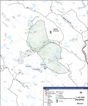
La Verendrye/Ogidaki Conservation Reserve is located approximately 60 km northeast of the City of Sault Ste. Marie in the southwest corner of Dablon Township, extending partially into Lunkie, La Verendrye and Hynes townships. It is approximately 6 km long and 2 km wide, running in a northwest to southeast direction. This site was regulated on June 7, 2003 and is 1,041 hectares in size (see figure 2). The Algoma Central Railway is located approximately 7 km north of the site; O'Connor Conservation Reserve is less than 5 km to the northwest, and Goulais River Provincial Park, approximately 2 km east of the site. Ogidaki Mountain, Ontario’s second highest point, borders the northeast boundary. Table 1 summarizes the administrative details of the conservation reserve.
Figure 1: La Verendrye/Ogidaki Conservation Reserve is characterized by a rolling landscape dominated by yellow birch, red and sugar maple with some super-canopy white spruce. Black spruce populates wetlands and low-lying valley areas.
(Photo by S.Walsh; September 2003)
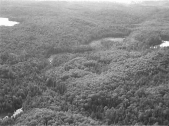
Figure 2: Site Location for La Verendrye/Ogidaki Conservation Reserve (C248)
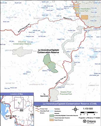
Enlarge Figure 2: Site Location for La Verendrye/Ogidaki Conservation Reserve (C248)
La Verendrye/Ogidaki Conservation Reserve is accessible from the southeast via the Whitman Dam Road. Old logging roads and trails provide varying degrees of access for full-sized vehicle, ATV, snowmobile and pedestrian traffic to/within the site. One road (a tertiary from the Whitman Dam Road) bisects the middle of the site, and portions of this road and another (which approaches from the south) delineate part of the eastern boundary. Several trails, more suitable for ATV and/or snowmobile traffic, are off-shoots from the old logging road system. These trails are scattered throughout the site in the northern and southern portions. Most of the trails follow hydrological features such as small lakes, creek systems and wetlands within, and adjacent to the conservation reserve. A half hectare patented private parcel is located immediately north of the road which bisects the conservation reserve, in the middle of (but not included in) the site.
Whenever possible, recognizable natural and cultural features, such as creeks, shorelines or old roads, have been used to delineate conservation reserve boundaries to facilitate on-the-ground identification. La Verendrye/Ogidaki Conservation Reserve’s boundary is defined by a combination of vectors, waterways and old roads. The site is divided into northern and southern portions by an access road which begins at the Whitman Dam Road. In the south half of the site, that road, a number of vectors and another old logging road define the eastern boundary. The southern boundary is vectored and the southwest boundary follows a creek system and the water’s edge of a lake identified as SSM 88. North of the road that bisects the site, the western boundary is defined by waterways and a vector. O'Connor Creek defines the northwest boundary and vectors define the northeast boundary (see Appendix A, Map 1).
Table 1. Location and administrative details for La Verendrye/Ogidaki Conservation Reserve.
| Name | La Verendrye/Ogidaki Conservation Reserve (C248) |
|---|---|
| Site Region - Site District (Hills 1959) | 4E-2 (Batchewana) |
| Eco Region - Eco District (Crins and Uhlig 2000) | 5E-13 |
| OMNR Administrative Region/District/Area | Northeast Region/Sault Ste. Marie District/ Algoma Area |
| UTM co-ordinates | 272684E I 5206992N (Zone 17 NAD 83) |
| Area | 1,039 ha |
| Nearest City /Town | Approximately 60 km northeast of the City of Sault Ste. Marie |
| Township(s) | Dablon Lunkie, Hynes, La Verendrye |
| OBM Numbers | 2016720052000 & 2017270052000 |
| Topographical Map Number I Name | 41-K 16 Searchmont 41-J 13 Ranger Lake 41-0 04 Welcome Lake 41-N 01 Batchewana |
| Wildlife Management Unit | 35 |
| Forest Management Unit | Algoma Forest |
| Regulated | June 7, 2003 |
| SCI Completed | February, 2005 |
La Verendrye/Ogidaki Conservation Reserve is located within Hill’s Site District 4E-2 (1959), also recognized as Eco District 5E-13 (Crins and Uhlig 2000). This ecological unit is characterized by moderately rolling Precambrian uplands and moderate broad valleys of sand and silt. Fine sand and silt occur as a thin layer of sorted materials over coarser sand, bedrock, and as deep deposits in valleys. Coarse and medium sands are common on the ridges. Hard maple and yellow birch are common on the upper slopes. Hemlock (Tsuga canadensis.) and white pine (Pinus strobus) grow on fresh sites. White spruce (Picea glauca), eastern white cedar (Thuja occidentalis), and balsam fir (Abies ba/samia) are found commonly on clays of middle slopes and cooler valleys. Black spruce (Picea mariana) and larch (Larix sp.) are found in cold wet areas (Hills 1959).
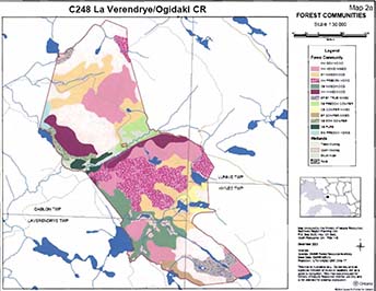
The diversity of landforms and vegetation combinations for La Verendrye/Ogidaki Conservation Reserve is considered to be medium. According to King et al. (2004), there are 23 combinations based on the number and variety of natural landscape features, landforms, richness, and evenness of biological components. Nearly 70% of the site is composed of sugar maple, red maple and yellow birch forest communities. Wetlands increase the diversity of the site, along with black spruce, eastern white cedar, balsam fir and white birch communities, which constitute nearly 30% of the site. Photos of the conservation reserve can be found in Appendix B.
4.2 History of the site
Lumber, minerals, fish and fur attracted the first people to the Lake Superior/Algoma Forest area. Trading posts and lumber mills were established along the Great Lakes waterways, trails and corduroy roads were built to increase accessibility to more northern locations, and railways were eventually developed for long hauls of minerals and lumber.
The booming fur harvest industry of the 1730s was dominated by the Hudson’s Bay Company, until an explorer sought to expand fur trading to western provinces. Beginning in Lake Superior, Pierre Gaultier Sieur de La Verendrye traveled west in search of a route that would lead to plentiful fur harvesting opportunities, and to the Pacific Ocean. He established trading posts along his westward journey, including the first trading fort on Lake Winnipeg (Canadian Heritage Gallery 2004). When the formal naming of townships began in the late 1960s, they were frequently chosen to commemorate individuals such as war heroes and the first explorers who contributed greatly to their communities and country; hence the name La Verendrye, which was given to a township north of Sault Ste. Marie. Similarly, Lunkie Township was selected to honour Antti A. Lunkie, the Royal Canadian Air Force’s Leading Aircraftsman (Northern Ontario Toponymy Site 2004).
The first Sault Ste. Marie sawmill, built in the 1780s, was intended to provide lumber for trading posts along the Great Lakes water route. Nearly a century later, larger sawmills and pulp mills were scattered throughout the Algoma Area. By the 1900s, a demand for lumber increased, which additionally created the need for more roads and railways. Evidence of old logging and skid roads exist within and in the vicinity of the conservation reserve. The Algoma Central Railway, less than 5 km from the site, was constructed in 1901 to haul lumber and iron ore from locations in the Algoma Forest. The Whitman Dam Road was built around the 1950s, along with a series of tertiary hauling roads. One of those tertiary roads bisects the conservation reserve, and others form portions of the eastern boundary (see figure 3). Logging within the vicinity of the conservation reserve has occurred since the early 1970s. According to King et al.(2004), past selective harvesting appears to have occurred immediately adjacent to the western boundary of the site.
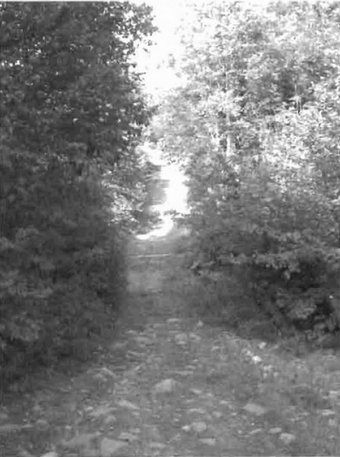
Figure 3: Forest access road, constructed in the 1970s, bisecting the conservation reserve.
(Photo by 5. Walsh; September 2003)
Evolving mining and forestry activities increased the risk of causing natural disturbances such as wildfires. Sparks created by coal-fired and steam-driven locomotives on the rail lines, posed a risk to rail-side vegetation. Fire surveillance personnel in the 1920s became increasingly popular, and foot patrols and fire bases were developed along the railway line, including within the Trout Lake area, approximately 4 km north of the conservation reserve (Vosper 2002). Less than 5 km east of the site, from the Goulais River eastward, two extensive forest fires burned in 1921 and 1964. Additionally, several small fires occurred within a 5 km radius of La Verendrye/Ogidaki Conservation Reserve in 1965, 1969, 1972, 1976 and 1991. These smaller fires were caused by lightning, recreational and railway activities. According to Ministry of Natural Resource’s data, there have been no fires recorded within the conservation reserve.
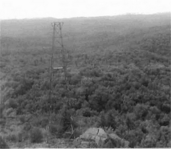
The Department of Lands and Forests constructed fire towers across the province between the 1920s and 1950s. As technology advanced in the 1960s and 1970s, the towers were used less, and aerial fire spotting and on-land fire fighting crews became popular. By the 1970s, a decision was made to destroy most of the towers in order to avoid liability issues. In some cases, the bottom 20 feet of ladders were removed from the base of the towers and the lookout cabins were removed from the top; others were completely dismantled (McBay pers.comm.). Today, tower remnants provide attractions for tourists, and act as landmarks for nearby municipalities.
Originally, the Ogidaki Mountain fire tower was located north of the conservation reserve, near Mekatlna Lake in Desbiens Township. The 80-foot steel tower was relocated to the top of the Ogidaki Mountain in 1968, and increased to 100 feet. According to MNR data, it was the last fire tower built in the province. Additionally, a cabin was constructed at the base of the mountain to accommodate staff. The Ogidaki Tower remains utilized for radio relay communications by the Ministry of Natural Resources and Quattra Communications (McBay pers.comm.).
Figure 4: Ogidaki Fire Tower (shown), relocated to the top of Ogidaki Mountain in 1968. The cabin and a portion of ladder were dismantled in the late 1970s.
(Photo by B. Knudsen; July 2002)
The name Ogidaki derives from the Ojibway culture meaning "high ground" or "on the hill" (Vosper 2002). Found immediately to the east of the site, the Ogidaki Mountain reaches 665 m above sea level, and is the second highest point in all of Ontario (Statistics Canada 2005).
Ministry of Natural Resources' data illustrates that La Verendrye/Ogidaki Conservation Reserve was originally proposed as two separate conservation reserves, separated by an old logging road. However, by the time the LUS was released in 1999, the proposal was for a single conservation reserve, and would exclude a small parcel of patented land in the middle of the site. This parcel was originally held under a land use permit, but was made available for purchase prior to 1999. The private land is not included within the regulated boundary of the La Verendrye/Ogidaki Conservation Reserve and therefore, is not subject to management direction in this SCI.
4.3 Inventories
Table 2 indicates the current status of natural heritage inventories that have occurred in La Verendrye/Ogidaki Conservation Reserve. Recommendations for future inventory needs are located in Table 3, Section 7.2.
Table 2. Existing inventory and survey information for La Verendrye/Ogidaki Conservation Reserve.
| Type of Inventory | Inventory Method | Date(s) of Inventory | Report |
|---|---|---|---|
| Life Science | Aerial reconnaissance | September 8, 2003 | King, L., Burkhardt, B. and Longyear, S. 2004. La reconnaissance Verendrye/Ogidaki Conservation Reserve (C248), Life Science Checksheet- Step 2. Unpublished Information. Ontario Ministry of Natural Resources. (Draft) |
| Earth Science | Aerial reconnaissance | September 8, 2003 | Kristjansson, F.J. 2004. Draft Earth Science Inventory Checklist, La Verendrye/Ogidaki (C248). Unpublished information. Ontario Ministry of Natural Resources. (Draft) |
| Recreation | Aerial and ground reconnaissance | Aerial: November 1999; July 2002; September 8, 2003; Ground: Fall 2000; July 2002; September 2003 | Walsh, S. 2004. Recreation Inventory Report - La ground Verendrye/Ogidaki Conservation Reserve (C248), Version 1. Unpublished Information. Ontario Ministry of Natural Resources. |
5.0 State of the resource
5.1 Key values
Key values are those values that make this site unique and have led to its designation as a conservation reserve. Their protection is paramount. The key values found within La Verendrye/Ogidaki Conservation Reserve include the following:
- Old, deciduous-dominated forest communities of sugar and red maple, and yellow birch interspersed with conifer communities of black spruce, eastern white cedar, balsam fir, white birch and super-canopy white spruce
- Wetlands, some of which serves as important moose aquatic feeding areas
Additional values as listed in Section 5.2 through Section 5.6 are also important. Descriptions in this section are not necessarily complete. If new values, key or otherwise, are identified, they will be added to this section. If any new value is considered significant, management guidelines may be modified, if required, to ensure its protection.
5.2 Earth sciences values
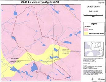
La Verendrye/Ogidaki Conservation Reserve is predominantly underlain by bedrock-drift complex, with areas of glaciofluvial outwash and organic deposits. The creek which bisects the site is located on a plain of glaciofluvial outwash composed of sand and gravel. The relief of the plain is low, with a suspected high water table. Small organic deposits occur throughout the site; including, along the creek that bisects the centre and in other wetland areas. Portions north and south of the glaciofluvial outwash plain are comprised mostly of bedrock (Kristjansson 2004). Additional research is required to confirm the presence of alluvial deposits and small peatland areas within the conservation reserve. More detailed analysis of earth science values is available in the Draft Earth Science Inventory Checklist for La Verendrye/Ogidaki Conservation Reserve (Kristjansson 2004).
5.3 Life sciences values
La Verendrye/Ogidaki Conservation Reserve is dominated by four deciduous-based forest communities which represent more than 65% of the entire site. Three of these communities consist of hard maple species, including dominant hardwood
Age distribution of forest communities within the site is predominately between 60 and 89 years. In the south, pockets of yellow birch have been aged between 120 and 149 years, approaching old growth status, and stands of sugar maple exist in both 30 to 59 years, and 90 to 119 years age ranges. Sugar maple and yellow birch dominated communities in the northern portion of the conservation reserve have been aged between 90 and 149 years, with some showing signs of decline. This is an indication that the stands are approaching old-growth status. A small stand of white birch, along the northeast vectored boundary, is less than 59 years. No stands within the site were identified as old-growth.
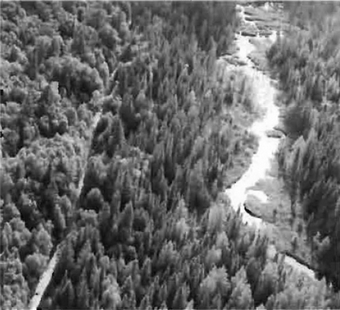
Figure 5: Aerial view of creek, wetland complex and black spruce forest community, paralleling abandoned logging road, which bisects the conservation reserve.
(Photo by B. Burkhardt; September 2003)
Stocking
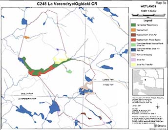
Several small unnamed lakes and creek systems are interspersed throughout and/or border the site, including O'Connor Creek which forms part of the northeast boundary. Bisecting the conservation reserve is an unnamed creek associated with a large wetland complex. Meadow marshes, thicket swamps, conifer swamps and muskegs are additional wetland types represented within the site, which also increase the site’s diversity. Some additionally provide aquatic feeding areas for moose. Several beaver (Castor canadensis) dams identified by the Ministry of Northern Development and Mines (MNDM 2004), within the conservation reserve, may have contributed to the formation of wetlands in this site. The water’s edge of an unnamed lake forms part of the southwest boundary. This lake is identified as a brook trout (Salvelinus fontinalis) lake.
Two registered trapline areas encompass La Verendrye/Ogidakl Conservation Reserve, and current trapping records confirm the presence beaver, mink (Mustela vision), marten (Martes americana), otter (Lontra Canadensis), weasel (Martes sp.), muskrat (Ondatra zibethicus), lynx (Lynx lynx), red fox (Vulpes vulpes), fisher (Martes pennanti), and raccoon (Procyon lotor). Hunters and trappers have also recorded frequent sightings of snowshoe hare (Lepus americanus) and ruffed grouse (Bonasa umbellus). Rare sightings have also included the endangered eastern cougar (Puma concolor cougar), as well as the northern gray wolf (Canis lupus occidentalis) which is classified as a species of concern (Committee of the Status of Species at Risk in Ontario 2004). This site also falls within two bear management areas. Refer to Sections 6.3.3 and 6.3.4 for more information on traplines and bear management areas.
According to the Ontario Breeding Bird Atlas (OBBA; www.birdsontario.org), this site is located within Region 35 within census square numbers 17KM79, 17KM70, 16GS29 and 16GT20. Recent confirmed breeding evidence for these census blocks include the wood duck (Aix sponsa), chestnut sided warbler (Dendroica pensylvanica), song sparrow (Melospiza melodia), yellow-rumped warbler (Denroica coronata), great blue heron (Ardea herodias), common loon (Gavia immer), American black duck (Anas rubripes), mallard duck (Anas platyrhynchos), common goldeneye (Bucephala clangula), common merganser (Mergus merganser), and sandhill crane (Grus canadensis). Some of these species may or may not be present within La Verendrye/Ogidaki Conservation Reserve, as the survey squares are larger than the site.
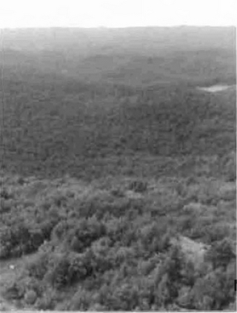
Figure 6: Rugged rolling topography of La Verendrye/Ogidaki Conservation Reserve provides scenic views of area. (Photo by B. Knudsen; July 2002)
More detailed analysis of life science values is available in the Life Science Inventory Checksheet for La Verendrye/Ogidaki Conservation Reserve (King et al. 2004).
5.4 Recreational values
The conservation reserve is located in the rugged Algoma landscape and is dominated by deciduous forests. Avid backpackers can enjoy the rolling hills and heights of land which provide broad views of the surrounding area. The diversity of upland and lowland conditions in the site, create opportunities to observe a range of habitats and species (Walsh 2004).
Bird watching, nature appreciation and photography can be enjoyed year-round. During autumn, deciduous-dominated forests are transformed into a collage of spectacular fall colours.
Small lakes in the southern portion of the conservation reserve may provide the opportunity for canoeing, kayaking, and swimming. In the absence of formal campsites within the conservation reserve, natural clearings can provide camping and/or picnic areas.
ATV and snowmobiling activities are seasonal pursuits which utilize old Jogging roads and trails within/adjacent to the site. Generally, these activities are associated with traditional big and small game hunting, and fishing activities. Winter months provide additional possibilities of cross-country skiing and snowshoeing within the conservation reserve.
Ogidaki Mountain and the fire tower located just outside of the northeastern portion of the conservation reserve may also be a choice destination for curious site-seers.
5.5 Cultural values
This site falls within the Robinson-Huron Treaty area. To date, no First Nation community has identified any specific Aboriginal values within this conservation reserve.
5.6 Research values
The Ontario Breeding Bird Atlas (OBBA; www.birdsontario.org) is a collaboration of survey data for breeding birds across the province. Volunteers survey 10 km2 areas assessing bird species and breeding populations. La Verendrye/Ogidaki Conservation Reserve falls within survey square numbers 17KM79, 17KM70, 16GS29 and 16GT20 of Region 35. To date, 11 breeding species have been confirmed for squares covering this site. Species identified within these survey blocks may or may not be present within the conservation reserve, as the blocks cover a larger area than the size of the site. Surveying for the OBBA will be completed in 2005.
5.7 Site condition
The area encompassed by La Verendrye/Ogidaki Conservation Reserve is described as having low disturbance, because it is estimated that less than 10% of the site has been disturbed by human or natural events.
Figure 7: Prominent ATV tracks along old Jogging road through the middle of conservation reserve.
(Photo by S. Walsh; September 2003)
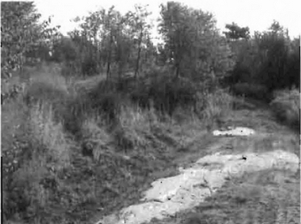
Several old logging roads are associated with this site. One such road passes from Whitman Dam Road through the middle of the conservation reserve and is used mainly by ATV and snowmobile traffic. This road is not maintained, and therefore is no longer a wide corridor. Two other branches of old forest access road form portions of the site’s eastern boundary. An aerial reconnaissance survey In September 2003, revealed a number of ATV trails throughout the site, especially along small lakes, traversing and paralleling wetlands. The absence of campsites, developments and private cottages, contribute to the site’s low degree of human disturbance.
Evidence of past selective tree harvesting was identified in 2003, in the central-western portion of the site, where the old forest access road extends beyond the boundary of the conservation reserve to the north and south. Age classification and species composition maps, available in the life Science Checksheet (King et al. 2004), may further support this evidence. Additionally, the forest community, found within this portion, consists predominantly of hard maple (desired for harvesting) and has been aged between 30 and 59 years, which may correspond with cutting around the 1970s. No harvesting has taken place in the site since It was identified in the LUS (OMNR) in 1999.
6.0 Management guidelines
All management guidelines in this SCI are based on direction contained in the LUS (OMNR 1999) and associated policy clarification statements (OMNR 2000). The management guidelines outlined in this section are specific to La Verendrye/Ogidaki Conservation Reserve and are intended to protect the site’s unique values. The guidelines in this document may be subject to change and may be amended as necessary. If a conflict between management guidelines exists, the conservation reserve will be managed to protect the Integrity of its natural values, while permitting compatible land use activities (OMNR 1997a).
Proposed new uses and/or development, as well as research and education activities will be reviewed on a case-by-case basis. Before new proposals can be permitted, the Test of Compatibility (see Appendix C) must be passed as well as consideration of cultural values according to Conserving a Future for our Past: Archaeology, Land Use Planning & Development in Ontario, Section 3 (Ministry of Culture 1998). In addition, all new proposals are subject to applicable Environmental Assessment Act (R.S.O. 1990, Chapter E.18) requirements.
The following management strategies have been devised to achieve the goal and objectives of the SCI for La Verendrye/Ogidaki Conservation Reserve. A summary table of the management guidelines for this site can be found In Appendix D. For the most up-to-date version of this summary table, please refer to the Crown Land Use Policy Atlas, located on the Internet at /page/crown-land-use-policy-atlas, or contact your local Ministry of Natural Resources office. The Crown Land Use Policy Atlas is a consolidation of existing local land use policies for Crown lands within the OLL planning area, an area that covers 45% of the province, extending from lake Simcoe In the south to the Albany River in the north.
6.1 Industrial activities
6.1.1 Commercial timber harvest
The total area contained within this conservation reserve (1,039 ha) has been withdrawn from the Algoma Sustainable Forest License area and no commercial timber harvesting will be permitted. Please refer to Section 6.4.3 for information regarding non-commercial wood harvesting.
6.1.2 Mining and exploration
There are no existing mining claims or leases within this conservation reserve. Mining and surface rights have been withdrawn from staking under the Mining Act (RSO 1990 Chapter M.14). Mineral exploration is not permitted.
6.1.3 Extraction of peat, soil, aggregate and other material
Extraction of peat, soil, aggregate and other material is not permitted.
6.1.4 Energy generation
New hydropower developments are not permitted within La Verendrye/Ogidaki Conservation Reserve. Wind power developments are prohibited under the Public Lands Act, Procedure PL 4.10.04 "Wind Power Development on Crown Land" (OMNR 2004b).
6.2 Existing and proposed development
6.2.1 Transportation corridors
6.2.1.1 Roads
According to the LUS (OMNR 1999), new roads for resource extraction will not be permitted except for those identified in Forest Management Plans prior to March 31, 1999. The old forest access road that bisects the conservation reserve was identified for future harvest operations west of the site. Future use of this road will be determined in the Algoma Forest Management Plan.
6.2.1.2 Trails
A number of trails appear to exist on the remnants of old forest access roads. These trails are primarily used by ATVs and snowmobiles. Such activities can continue unless the Ministry of Natural Resources determines that the activities are having a negative impact on the site’s protected values. Should activities on these trails degrade the landscape, the Ministry of Natural Resources will re-evaluate these permitted uses and determine a new strategy.
Any proposed new trails will be subject to the Test of Compatibility (see Appendix C) and applicable Ministry of Natural Resources' policies and procedures. Trail development in low-lying areas, and wetlands will be discouraged, as will trail development over shallow soils on rock outcrops. All new trail heads and trail routes must be recorded using new technologies (ie. global positioning systems) to ensure an accurate record of the location of the feature. This location information must be provided to the Sault Ste. Marie District, Ministry of Natural Resources.
6.2.2 Other corridor development/maintenance
No communication, energy transmission, or other non-road corridors are located within this conservation reserve. New corridor developments will be actively discouraged. Proposals for new corridors will be subject to the Test of Compatibility (see Appendix C) and applicable Ministry of Natural Resources' policies and procedures.
6.2.3 Natural heritage appreciation facilities/recreational structures
There are currently no existing authorized natural heritage appreciation facilities or recreational structures (ie. boardwalks, bird viewing platforms, kiosks, ski shelters, or interpretative signs).
New natural heritage appreciation facilities and recreation structures are permitted, subject to the Test of Compatibility (see Appendix C) and applicable Ministry of Natural Resources' policies and procedures.
6.2.4 Land disposition
Sale of Crown lands is not permitted, except for those situations described in the policy clarification tables (OMNR 2000).
There are no land use permits (LUPs) existing within this conservation reserve, but a small parcel of patented land is located in the middle of (but not included within) the site. New leases or LUPs may be issued for approved public uses (ie. not for private recreation camps), subject to the Test of Compatibility (see Appendix C) and applicable Ministry of Natural Resources' policies and procedures. These leases/permits will not be sold but may be eligible for enhanced tenure or transfer.
Enhanced tenure is defined as anything beyond the term and form of current tenure. All requests for transfer or enhanced tenure will be subject to the following screening criteria:
- Is the transfer or enhanced tenure consistent with the conservation reserve’s land use intent, which is the protection and enhancement of the site’s natural, recreational and cultural values?
- Is it consistent with the land disposition policies outlined in the District Land Use Guidelines, the Crown Land Use Policy Atlas, this SCI and any other applicable document?
- Does it adversely affect the values as identified in Section 5.0, and/or conflict with other uses?
- Is land needed by the Crown to protect significant natural or recreational values outlined in this SCI?
- Does the transfer or enhanced tenure clash with traditional Aboriginal uses, land claims or agreements?
- Are all rents, taxes, fees, rates or charges paid up for the existing LUP or lease?
6.3 Commercial activities
6.3.1 Commercial bait harvesting
Dablon Township is not allocated for baitfish harvesting operations, however, Lunkie, Hynes, and La Verendrye townships are allocated. New operations can be considered subject to the Test of Compatibility (see Appendix C) and applicable Ministry of Natural Resources' policies and procedures.
Under Public Lands Act PL 3.03.08 "Buildings for Bait Harvesting Management" (OMNR 2002), cabins for the purposes of bait harvesting may be constructed on Crown land. However, such buildings should be avoided within this conservation reserve.
6.3.2 Commercial fishing
There are no commercial fisheries within this conservation reserve. New operations may be considered subject to the Test of Compatibility (see Appendix C) and applicable Ministry of Natural Resources' policies and procedures.
6.3.3 Commercial fur trapping
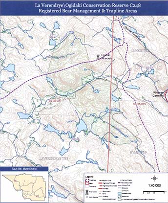
Most of La Verendrye/Ogidaki Conservation Reserve is within Registered Trapline Area SS-28, and the northern extent is covered by SS-27 (see Appendix A, Map 2). Both trapline areas are currently allocated to head trappers. If a head trapper surrenders a registered trapline, or the head trapper’s privileges are revoked, the registered trapline may be transferred to another trapper following allocation procedures. If the registered trapline is not transferred in due course, or remains unallocated for a significant period of time, reallocation of the trapline may occur following applicable district screening processes.
The establishment of new trapline trails will be considered following the procedure and criteria for new trails as outlined in Section 6.2.1.2. No trap cabins currently exist within the La Verendrye/Ogidaki Conservation Reserve.
6.3.4 Bear Management Areas
Bear Management Area (BMA) SS-35-037 covers a majority of the conservation reserve. The eastern portion of the conservation reserve, within Lunkie and Hynes townships, is covered by ss-35-035 (see Appendix A, Map 2). Transfers of BMAs within this conservation reserve may be permitted in cases where the current operator sells their bear hunting business to another operator and the BMA transfer is approved. If an operator surrenders the BMA or the BMA is revoked, reallocation of the BMA may occur following applicable district screening processes.
6.3.5 Commercial food collection
No commercial food harvesting ventures exist within the conservation reserve. Any new venture will require a permit issued by the Ministry of Natural Resources, and will be subject to the Test of Compatibility (see Appendix C) and applicable Ministry of Natural Resources' policies and procedures.
6.3.6 Commercial non-timber forest products
Commercial harvesting of non-timber forest products is not consistent with the intent of the conservation reserve and will not be approved.
6.3.7 Outpost camps/main base lodges
No outpost camps or main base lodges exist within the conservation reserve. New outpost camps and main base lodges may be permitted, subject to the Test of Compatibility (see Appendix C) and applicable Ministry of Natural Resources' policies and procedures.
6.4 Non-commercial activities
6.4.1 Nature appreciation/recreation activities
Off-trail hiking, cross-country skiing, snowshoeing, and other non-motorized activities will be permitted within this conservation reserve. However, should the impact of these activities degrade the landscape, the Ministry of Natural Resources will re-evaluate these permitted uses and decide upon a new strategy for this site. New trails to support these activities may be considered. Please refer to Section 6.2.1.2 for more details related to trail development.
6.4.2 Camping
There are no maintained campsites or campgrounds within this conservation reserve although, natural clearings have been identified as potential tenting areas. Crown land camping policies apply, unless significant adverse effects on protected values necessitate further planning and management for this activity. Campers should avoid sensitive areas within the conservation reserve (ie. wetlands and shallow soils), and avoid clearing trees for campsites.
6.4.3 Non-commercial consumptive resource use
Cutting of trees for non-commercial purposes may be authorized via a permit issued by the local Ministry of Natural Resources office, subject to review and determination of the impact that such cutting would have on the values identified in Section 5.0. Such permits are intended only for leaseholders or land use permit holders (LUP) within the conservation reserve who do not have road access to their property and have no alternate wood source outside of the conservation reserve. Generally, this permit is intended to cover fuel wood, dock stringers, and other occasional small scale uses; however, because there are no lease or LUP holders within the conservation reserve, permits will not be issued.
Non-commercial harvesting of non-timber forest products such as berries and mushrooms can occur provided the values of the site, identified in Section 5.0- State of the Resource, are not jeopardized.
6.4.4 Hunting and fishing
Hunting and fishing are traditional activities within this conservation reserve. In conjunction with current hunting and/or fishing regulations and conservation reserve policy, both hunting and fishing are permitted to continue.
6.4.5 ATV and snowmobile use
Several old roads and informal trails have been identified, throughout the conservation reserve. Please refer to Section 6.2.1.2 for more information on trails. In general, off-trail use of ATVs and snowmobiles is not permitted. However, off-trail use is permitted for licensed trappers to access their traplines and for licensed bait harvest operators to conduct bait harvest operations. Off-trail ATV and snowmobile use are also permitted for the direct retrieval of big game by hunters. In all these cases, off-trail use is only permitted provided the protection of the site’s values is not compromised. Should the impact of off-trail ATV and snowmobile use degrade the landscape, the Ministry of Natural Resources will re-evaluate these permitted uses and determine a new strategy.
6.5 Resource management activities
Resource management activities refer to those tools used to protect and enhance the values of this conservation reserve. Some management activities may require the use of intrusive techniques. Under normal circumstances, some of these techniques would not be permitted to occur in the conservation reserve; however, if they are found to be necessary, they may be applied under controlled conditions, to achieve a desired result. Infrastructure such as trails and buildings may need to be constructed to support activities such as prescribed burns, forest regeneration, wildfire control, and insect and disease control. Activities described in this section will be deemed acceptable if the ultimate outcome is in compliance with the management intent for this conservation reserve.
6.5.1 Insect and disease control
This conservation reserve will be maintained in as natural a state as possible. Insect and disease control measures should only be considered if the identified values are significantly threatened.
6.5.2 Fire management
The Ministry of Natural Resources recognizes fire as an essential process fundamental to the ecological integrity of conservation reserves. In accordance with existing conservation reserve policy and the Forest Fire Management Strategy for Ontario (OMNR 2004c), forest fire protection will be carried out as on surrounding lands.
Whenever feasible, the Ministry of Natural Resources' fire program will endeavor to use "light on the land" techniques, which do not unduly disturb the landscape, in this conservation reserve. Examples of light on the land techniques may include limiting the number of trees felled during the fire response efforts.
Opportunities for prescribed burning to achieve ecological or resource management objectives may be considered. These management objectives will be developed with public consultation prior to any prescribed burning, and will be reflected in the document that provides fire management direction for this conservation reserve. Plans for any prescribed burning will be developed in accordance with the Ministry of Natural Resources Prescribed Burn Planning Manual (OMNR 1997b) and the Environmental Assessment Act (R.S.O. 1990, Chapter E.18).
6.5.3 Fish and wildlife management
New fish and wildlife management activities may be considered, but will require the approval of a separate fish/wildlife management plan, which must be referenced in this SCI and/or an amendment to this SCI to include specific management prescriptions. New fish and wildlife management activities are also subject to the Test of Compatibility (see Appendix C) and applicable Ministry of Natural Resources' policies and procedures.
6.5.4 Vegetation management
New vegetation management activities may be considered but will require the approval of a separate vegetation management plan, which must be referenced in this SCI and/or an amendment to this SCI to include specific management prescriptions. New vegetation management activities are also subject to the Test of Compatibility (see Appendix C) and applicable Ministry of Natural Resources' policies and procedures.
6.5.5 Forest renewal
Preference will be given to natural regeneration following any disturbance in the conservation reserve. In some cases, regeneration may be artificially assisted when it is deemed appropriate to mitigate against human disturbances (ie. illegal occupation and trespass).
6.6 Research
Scientific research is encouraged, by qualified individuals or institutions, that contributes to a better understanding of the natural and cultural values protected by this conservation reserve, or that advances the protection, planning and management of these values. The Sault Ste. Marie District Planner should be contacted for information on research and/or monitoring opportunities within this conservation reserve. Proposals to conduct research should be directed to the Algoma Area Supervisor, Ministry of Natural Resources, Sault Ste. Marie District Office, and will be subject to the Test of Compatibility (see Appendix C) and applicable Ministry of Natural Resources' policies and procedures. Any site that is disturbed during research activities is to be rehabilitated as closely as possible to its original condition. Collecting may only be permitted as part of an authorized research project and may be subject to appropriate permits and conditions.
Existing Forest Resource Inventory surveys and approved resource monitoring activities are permitted to continue.
6.7 Marketing
No active marketing of this conservation reserve by Sault Ste. Marie District, Ministry of Natural Resources is anticipated.
6.8 First Nations
Traditional activities and Aboriginal rights, as defined in the Robinson-Huron Treaty and other applicable legislation, will not be affected within or by the boundaries of this conservation reserve. Any First Nation land claims within this area will be addressed according to appropriate Ministry of Natural Resources' procedures. When possible, the Ministry of Natural Resources will work with the Ontario Ministry of Culture and/or any First Nation community within the Robinson-Huron Treaty area to identify archaeological sites to be protected.
7.0 Recommendations
7.1 Additions to the reserve
La Verendrye/Ogidaki Conservation Reserve is comprised of vectored and natural feature boundaries. In a more ecological approach to boundary identification, the northwest boundary should be extended to include the creek system. Similarly, the northeast corner of the site should follow the O'Connor Creek entirely. Along the south-central boundary, the large vector could be altered to run parallel with the abandoned tertiary road, and include a portion of an unnamed creek (King et al. 2004).
These additions would improve the boundaries of the site by removing vectors and providing more readily identifiable biological boundaries. New boundaries would protect additional creek systems, wetlands and forest communities in conjunction with those already being protected in La Verendrye/Ogidaki Conservation Reserve.
7.2 Future needs and considerations
The values protected by this site should be considered in land use management activities on adjacent properties to ensure sufficient protection of the site’s core values.
Table 3 (on the following page) highlights future needs and considerations for La Verendrye/Ogidaki Conservation Reserve.
7.3 Monitoring
Periodic monitoring of human activities and/or their impacts within this conservation reserve will be conducted. A schedule for cursory field monitoring will be identified within the District’s annual compliance plan and an IFM (Integrated Field Monitoring) inspection report will be filed at the Sault Ste. Marie District Office. The Algoma Area Supervisor will oversee these activities. In addition, Conservation Officers will complete periodic compliance monitoring to ensure the protection mandate is maintained. If at any time human activities are deemed to be negatively impacting the protected features, the activities will be reviewed and measures taken to mitigate any disturbance.
Approved inventory, monitoring, assessment, or research activities that are compatible with protection objectives are encouraged. Any area that is disturbed during research activities is to be rehabilitated as closely as possible to its original condition. The Algoma Area Supervisor may apply additional conditions.
Table 3. Future needs and considerations for La Verendrye/Ogidaki Conservation Reserve.
| Future Needs/ Considerations | Details |
|---|---|
| Complete Life Science Inventory | The Northeast Region should complete the final stage of the life science inventory. This would include an assessment of the site’s significance and its contribution to the parks and protected areas program. |
| Complete Earth Science Inventory | Efforts should be made by the Northeast Region to complete the final stage of the earth science inventory, and include a more detailed analysis of earth science features within this site. |
| Road/ Trail Inventory | Determine location, extent and condition of all roads and trails within the conservation reserve; ensure all trail heads and routes are recorded using Global Positioning Systems (GPS). |
| Boundary Marking | Vectored boundaries should be clearly marked for long-term recognition, so that the site’s core values are protected from surrounding land use activities. |
| Winter Recreation Assessment | Efforts should be made during winter months to further assess the intensity of snowmobiling and other winter recreation activities occurring within the conservation reserve. |
| ATV Assessment | Determine the extent and location of ATV activities occurring within the conservation reserve; to include an assessment of wetland sensitivity to these activities. |
| Partnership Development | Efforts should be made to work with partners (such as Aboriginal communities, the Ontario Forest Research Institute (OFRI), Sault College of Applied Arts and Technology) to gather baseline data on this site to assist with future monitoring and inspection activities. |
| Education | Educate public who use Crown land features in/around this conservation reserve about the site’s natural heritage; protection intent of the CR; permitted uses; etc. |
| Funding | Efforts should be made to obtain funding to support the above listed items, including monitoring, assessment, and inspection requirements for this site. |
8.0 Implementation, review and revisions
8.1 Responsibility
The Sault Ste. Marie District will be responsible for implementing the management policies and guidelines for La Verendrye/Ogidaki Conservation Reserve. The primary role will be to provide public information and compliance monitoring to ensure adherence to current policies and guidelines.
8.2 Review and revisions
The La Verendrye/Ogidaki Conservation Reserve SCI will be reviewed every five years by the District Planner to confirm and update the information in this document. Revisions to this document will be subject to requirements as specified in the Environmental Assessment Act (R.S.O. 1990, Chapter E.18). If changes in management direction are needed at any time, the significance of the changes will be evaluated. Minor amendments to the plan that do not alter the overall protection objectives may be considered and approved by the Area Supervisor without further public consultation. All minor amendments to the SCI will be documented in Appendix F. In assessing major amendments, the need for a more detailed Resource Management Plan (RMP) will first be considered. Where a RMP is not considered necessary or feasible, a major amendment to management direction may be considered with public consultation. Major amendments will be recommended by the District Manager and approved by the Regional Director, and will follow the appropriate guidelines (OMNR 2001b).
Literature cited
Canadian Heritage Gallery. 2004. Sieur de Ia Verendrye- Canadian Heritage Gallery. [Accessed: November 11, 2004] www.canadianheritage.org/reproductions/10114htm.
Committee of the Status of Species at Risk in Ontario (COSSARO). 2004. [Accessed: November 2, 2004] www.ontarioparks.com/english/sar-status.html.
Crins, W.J. 1996. Life Science Gap Analysis for Site District 4E-3. Unpublished information. Ontario Ministry of Natural Resources.
Hills, G.A. 1959. A Ready Reference for the Description of the Land of Ontario and Its Productivity. Preliminary Report. Ontario Department of Lands and Forests. Maple. Ontario.
King, L., Burkhardt, B. and Longyear, S. 2004. La Verendrye/Ogidaki Conservation Reserve (C248), Life Science Checksheet- Step 2. Unpublished information. Ontario Ministry of Natural Resources.
Kristjansson, F.J. 2004. Draft Earth Science Inventory Checklist, La Verendrye/Ogidaki (C248). Unpublished Information. Ontario Ministry of Natural Resources.
McBay, P. Fire Management Supervisor, Ministry of Natural Resources. Personal Communication. November, 2004.
Ministry of Culture. 1998. Conserving a Future for Our Past: Archeology Land Use Planning and Development in Ontario. Ministry of Culture, Heritage and Libraries Branch - Heritage Operations Unit.
Ministry of Northern Development and Mines. 2004. Claimaps, Mines and Minerals Division. Queen’s Printer for Ontario. [Accessed: November 4, 2004] http://www.mndm.gov.on.ca.
Northern Ontario Toponymy Site. 2004. [Accessed: November 11, 2004] http://142.51.17.253/jrp/nots/indexnew.htm.
Ontario Breeding Bird Atlas. 2004. [Accessed: November 2, 2004] www.birdsontario.org/atlas.
Ontario Ministry of Natural Resources. 1997a. Conservation Reserves. Lands and Waters Branch Policy. Public Lands Act, PL 3.03.05. Date Issued: February 11, 1997.
Ontario Ministry of Natural Resources. 1997b. Prescribed Burn Planning Manual. AFFMB Publication No. 313. Ontario Ministry of Natural Resources.
Ontario Ministry of Natural Resources. 1999. Ontario’s Living Legacy Land Use Strategy. Queen’s Printer for Ontario: Ontario, Canada.
Ontario Ministry of Natural Resources. 2000. Policy Clarification for Conservation Reserves. Unpublished document. September 2000.
Ontario Ministry of Natural Resources. 2001a. Forest Information Manual. Queen’s Printer for Ontario: Toronto, Ontario.
Ontario Ministry of Natural Resources. 2001b. Procedures for the Amendment of Ministry of Natural Resources Land Use Direction. Ontario Ministry of Natural Resources.
Ontario Ministry of Natural Resources. 2002. Buildings for Bait Harvesting Management. Public Lands Act, PL 3.03.08.
Ontario Ministry of Natural Resources. 2004a. Crown Land Use Policy Atlas- Policy Report, C243 Wagong Lake Forest. [Accessed: October 25, 2004] http://crownlanduseatlas.mnr.gov.on.ca/pdfs/C243.pdf.
Ontario Ministry of Natural Resources. 2004b. Wind Power Development on Crown Land. Lands and Waters Policy Branch. Public Lands Act, PL 4.10.04. Date Issued: January 27, 2004.
Ontario Ministry of Natural Resources. 2004c. Forest Fire Management Strategy for Ontario. Queen’s Printer for Ontario: Ontario, Canada.
R.S.O. 1990, Chapter E.18. Environmental Assessment Act. [Accessed: September 15, 2003] http://www.e-laws.gov.on.ca/DBLaws/Statutes/English/90e18_e.htm.
R.S.O. 1990, Chapter M.14. Mining Act. [Accessed: September 15, 2003] http://www.elaws.gov.on.ca/DBLaws/Statutes/English/90m14_e.htm.
Statistics Canada. 2005. Principal Heights By Range or Region. [Accessed: January 5, 2005] www.statcan.ca/english/Pgdb/phys03.htm.
Thompson, J. 2001. Northeast Region Guidelines on the Planning Process for Conservation Reserves: Statements of Conservation Interest and Resource Management Plan. Unpublished information. Ontario Ministry of Natural Resources.
Vosper, R. 2002. Forest Tracks, Mile By Mile, Second Edition. Ontario.
Walsh, S. 2004. Recreation Inventory Report- La Verendrye/Ogidaki Conservation Reserve (C248). Unpublished information. Ontario Ministry of Natural Resources.
Appendix A: La Verendrye/Ogidaki Conservation
Reserve Maps
Map 1: Recreational and other values in La Verendrye/Ogidaki Conservation Reserve.
Enlarge Map 1: Recreational and other values in La Verendrye/Ogidaki Conservation Reserve.
Map 2: Registered Bear Management & Trapline Areas within La Verendrye/Ogidaki Conservation Reserve
Map 3: Landforms In Conservation Reserve, according to provincial landform coverage. (Source: King et al. 2004. Life Science Checksheet-Step 2)
Map 4: Forest communities in La Verendrye/Ogidaki Conservation Reserve. (Source: King et al. 2004. Life Science Checksheet-Step 2)
Map 5: Wetlands in La Verendrye/Ogidaki Conservation Reserve.
Enlarge Map 5: Wetlands in La Verendrye/Ogidaki Conservation Reserve.
Appendix B: La Verendrye/Ogidaki Conservation
Reserve photos
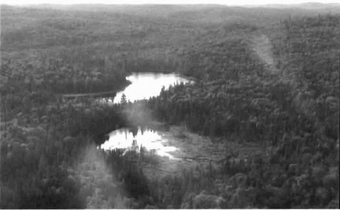
Photo 1: Wetland complex located in the southern portion of the conservation reserve.
(Photo by S. Walsh; July 2002)
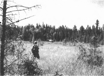
Photo 2: View looking west along creek and wetlands (shore fen, treed fen and conifer swamp) which bisect the site. A black spruce dominated forest community parallels the wetland complex, and hard maple species dominate beyond the black spruce in this area.
(Photo by S. Walsh; July 2002)
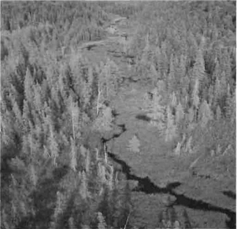
Photo 3: View from central-western boundary looking south towards rolling landscape, consisting predominantly of red maple and sugar maple forest communities.
(Photo by B. Burkhardt; September 2003)
Photo 4: View looking west from the southeast boundary. Wetlands are a mix of open water marsh, meadow marsh, shore fen, poor fen and rich cedar conifer swamp.
(Photo by B. Burkhardt; September 2003)
Appendix C: Test of compatibility
Test of Compatibility
The Conservation Reserve policy provides broad direction with regard to the permitted uses. The policy provides only an Indication of the variety of uses that will be considered acceptable in conservation reserves. Any new uses, and commercial activities associated with them, will be considered on a case by case basis, and, subject to the following test of compatibility. To ensure a standard screening process is followed, reviews of all current and new activities will be subject to the screening criteria as specified by the Environmental Assessment Act (R.S.O. 1900, Chapter E.18).
The following outlines the two steps involved in performing a Test of Compatibility. An assessment of current activities would only follow step two, which focuses on the impacts. An assessment of any new activity would consider the impact of the activity and its conformity to the SCI/RMP.
-
Conformity to SCI/RMP: SCI describe values for which an area has been set aside and the range of appropriate uses that will be permitted in the area. SCI may also speak to the acceptability of other 'new' uses currently not occurring in the area.
The first 'test' is: "do proposed new land uses and/or commercial activities conform to the direction of the SCI/RMP for the conservation reserve? Would the new use(s) depart from the spirit of appropriate indicator land uses in the SCI/RMP?"
- Impact Assessment: If the proposed use(s) pass test 1 it is important to determine their impact on the area before they are approved. This should include the following:
- Impact on natural heritage values: "will the new use(s) impact any natural values in the area? If so how and to what degree? Is it tolerable?"
- Impact on cultural values: "will the new use(s) impact an historical or archaeological values in the area?"
- Impact on research activities: "will the new use(s) affect research activities in the area?" Impact on current uses: "will the new use(s) have any negative impact on the array of current uses?"
- Impact on area administration: "will the new use(s) increase administrative costs and/or complexity?" (For example, the cost of area monitoring, security and enforcement).
- Impact on accommodating the use outside the conservation reserve: "Could the use(s) be accommodated as well or better outside the conservation reserve?"
- Impact on socio-economics of the area: "will the new use(s) affect the community(ies) surrounding the area in a positive or negative way?" (For example, will the new use make an area less remote thereby affecting a local tourism industry that is dependent on the area’s remoteness for its appeal?"
- Impact on area accessibility: "does the new use(s) give someone exclusive rights to the area or a portion of the area to the exclusion of other existing uses?"
Appendix D: Summary of permitted uses
The following Policy Report was obtained from the Crown Land Use Policy Atlas website during completion of this SCI (February, 2005). Changes may have been made to this policy report since that time. For the most recent version of this policy report, please refer to the Crown Land Use Policy Atlas on the Internet at /page/crown-land-use-policy-atlas or contact your local Ministry of Natural Resources office.
Crown land use policy atlas-policy report
C248
La Verendrye/Ogidaki
Updated: June 29, 2004
Identification:
| ID: | C248 |
|---|---|
| Area Name: | La Verendrye/Ogidaki |
| Area (ha): | 1,039 |
| Designation: | Conservation Reserve - (Ontario’s Living Legacy) |
| MNR District(s): | Sault Ste. Marie |
Description:
This conservation reserve, in Site District 4E-2 includes an old deciduous forest growing on top of hilly moraine deposits. The main forest types are yellow birch, sugar and red maple and white and black spruce.
La Verendrye/Ogidaki was regulated as a conservation reserve on May 21, 2003.
Land use intent:
Management of this area is also governed by the general policies contained in the Land Use Strategy (1999)
Management direction:
Those uses and management activities not listed in the following table are governed by existing conservation reserve policy. Over time the management direction will be elaborated in a Statement of Conservation Interest or Resource Management Plan. Any new uses, and commercial activities associated with conservation reserves, will be considered on a case by case basis, and they must pass a test of compatibility to be acceptable. Compatibility is normally determined through a planning process.
Commercial activities
| Activity | Permitted | Guidelines |
|---|---|---|
| Aggregate Extraction | No | |
| Bait Fishing Existing: | Yes | Existing use permitted to continue, unless there are significant demonstrated conflicts. |
| Bait Fishing New: | Maybe | New operations can be considered, subject to the "test of compatibility" |
| Commercial Fishing Existing: | Yes | Existing use permitted to continue, unless there are significant demonstrated conflicts. |
| Commercial Fishing New: | Maybe | New operations can be considered, subject to the "test of compatibility". |
| Commercial Fur Harvesting Existing: | Yes | Existing use permitted to continue, unless there are significant demonstrated conflicts. Existing trap cabins can continue; new cabins are not permitted. |
| Commercial Fur Harvesting New: | Maybe | New operations can be considered, subject to the "test of compatibility". |
| Commercial Hydro Development | No | |
| Commercial Timber Harvest | No | |
| Commercial Tourism Existing: | Yes | Existing authorized facilities can continue, unless there are significant demonstrated conflicts. |
| Commercial Tourism New: | Maybe | New tourism facilities can be considered during the planning for an individual reserve. |
| Bear Hunting by Non residents (guided) Existing: | Yes | Existing authorized operations permitted to continue. |
| Bear Hunting by Non residents (guided) New: | No | New operations not permitted. |
| Outfitting Services Existing: | Yes | Existing authorized operations permitted to continue. |
| Outfitting Services New: | Maybe | New operations can be considered during the planning for an individual reserve. |
| Outpost Camps Existing: | Yes | Existing authorized facilities permitted to continue. |
| Outpost Camps New: | Maybe | New facilities can be considered during the planning for an individual reserve. |
| Resorts/lodges Existing: | Yes | Existing authorized facilities permitted to continue. |
| Resorts/lodges New: | Maybe | New facilities can be considered during the planning for an individual reserve. |
| Energy Transmission and Communications Corridors Existing: | Yes | These facilities should avoid conservation reserve lands wherever possible. |
| Energy Transmission and Communications Corridors New: | No | |
| Food Harvesting (Commercial) Existing: | Maybe | |
| Food Harvesting (Commercial) New: | Maybe | |
| Mineral Exploration and Development | No | |
| Peat Extraction | No | |
| Wild Rice Harvesting Existing: | Yes | |
| Wild Rice Harvesting New: | Maybe |
Land and resource management activities
| Activity | Permitted | Guidelines |
|---|---|---|
| Crown Land Disposition Private Use: | Maybe | Sale of lands is not permitted, except for minor dispositions in support of existing uses (e.g. reconstruction of a septic system). Renewals of existing leases and land use permits are permitted. Requests for transfer of tenure will be considered in the context of the Statement of Conservation Interest or Resource Management Plan. |
| Crown Land Disposition Commercial Use: | Maybe | New leases or land use permits permitted for approved activities. Tourism facilities can apply to upgrade tenure from LUP to lease. |
| Fire Suppression | Yes | Fire suppression policies are similar to adjacent Crown lands, unless alternative fire policies have been developed through a planning process. |
| Fish Habitat Management | Maybe | |
| Fish Stocking | Maybe | Conservation Reserves policy indicates that "featured species management" may be permitted. |
| Insect/disease Suppression | Maybe | |
| Inventory/Monitoring | Yes | |
| Prescribed Burning: | Maybe | |
| Roads (Resource Access) Existing: | Yes | Existing roads can continue to be used. Continued use will include maintenance and may include future upgrading. |
| Roads (Resource Access) New: | Maybe | New roads for resource extraction will not be permitted, with the exception of necessary access to existing forest reserves for mineral exploration and development. |
| Vegetation Management | Maybe | Conservation Reserves policy indicates that Featured Species Management and Natural Systems Management may be permitted. Vegetation management can be considered in a planning process. |
| Wildlife Population Management | Maybe |
Science, education and heritage appreciation
| Activity | Permitted | Guidelines |
|---|---|---|
| Collecting | No | |
| Historical Appreciation | Yes | |
| Nature Appreciation | Yes | |
| Photography and Painting | Yes | |
| Research | Yes | |
| Wildlife Viewing | Yes |
Recreation activities and facilities
| Activity | Permitted | Guidelines |
|---|---|---|
| All Terrain Vehicle Use On Trails: | Yes | Existing use permitted to continue where it does not adversely affect the values being protected. ATV use off trails is not permitted except for direct retrieval of game. |
| All Terrain Vehicle Use Off Trails: | No | |
| Campgrounds | Maybe | |
| Food Gathering | Yes | |
| Horseback Riding (trail) | Yes | Existing use on trails permitted. |
| Hunting | Yes | |
| Mountain Bike Use | Yes | Existing use on trails permitted. |
| Motor Boat Use Commercial: | Yes | |
| Motor Boat Use Private: | Yes | |
| Non-motorized Recreation Travel | Yes | |
| Private Recreation Camps (Hunt Camps) Existing: | Yes | Existing camps permitted to continue, and may be eligible for enhanced tenure, but not purchase of land. |
| Private Recreation Camps (Hunt Camps) New: | No | |
| Rock Climbing: | Maybe | |
| Snowmobiling On Trails: | Yes | Existing use permitted to continue where it does not adversely affect the values being protected. |
| Snowmobiling Off Trails: | Maybe | Snowmobile use off trails is not permitted, except that snowmobiles may be used for direct retrieval of game. |
| Sport Fishing | Yes | |
| Trail Development Existing: | Maybe | Development of trails for a variety of activities (e.g. hiking, cross-country skiing, cycling, horseback riding, snowmobiling) can be considered as part of planning for an Individual reserve. |
| Trail Development New: |
Note: The policies outlined in this table do not supersede any Aboriginal or treaty rights that may exist, or other legal obligations.
Management of this conservation reserve is carried out within the context of Conservation Reserve policy as amended by the policies for new conservation reserves outlined in the Ontario’s Living Legacy Land Use Strategy.
Source of direction:
Ontario’s Living Legacy Land Use Strategy (1999)
Conservation Reserves Policy (1997)
Sault Ste. Marie District Land Use Guidelines (1983)
Appendix E: Regulation public consultation materials
Note that some information in these materials is no longer current - the documents are provided here as a matter of historical record.
64 Church Street
Sault Ste. Marie ON P6A 8H8
November 10, 1999
To: Ontario living legacy stakeholders
Dear Sir/Madam:
On July 16, 1999, the Ontario Government released the Ontario’s Living Legacy Land Use Strategy, a broad land use approach to the planning and management of much of the Crown lands in central and parts of northern Ontario. A major part of the Ontario’s Living Legacy Land Use Strategy was a government commitment to the biggest expansion of provincial parks and conservation reserves in Ontario’s history. Ontario intends to add 378 new areas to its protected areas system. Ontario’s Living Legacy is a momentous achievement that will be recognized around the world as a significant contribution to sustaining our natural environment. A copy of the Land Use Strategy is available from our office upon request.
In accordance with the recommendations in the Land Use Strategy, the Ministry of Natural Resources is now implementing the process of establishing the first set of 64 protected areas from the Land Use Strategy. The first step in this process is consultation on the boundaries of these 64 areas. The remaining 314 proposed protected areas will be consulted upon in the future.
As stated in the Land Use Strategy, the boundary refinement process will consider local ecological information and will attempt to establish regulated boundaries along features that can be identified on the ground. The boundary refinement process may result in modest increases or decreases in the sizes of the protected areas. Any existing commitments for the areas, which were considered during the land use planning process, will be considered in defining the final boundary.
This list of 64 areas includes the proposed Wabos North, Wabos South, Jullineau, La Verendrye/Ogidaki, Garden River Forest, Tilley Creek West, O'Connor and Harmony Conservation Reserves.
The Land Use Strategy established the Ministry’s intent to add these Crown lands to Ontario’s protected areas system, following the extensive public consultation associated with Ontario’s Living Legacy and the Lands for Life land use planning initiatives between 1997 and 1999. Prior to the finalization of the boudnary of these conservation reserves proposed for regulation under the Public Lands Act, the Ministry in inviting public comment ont he proposed boundaries.
Your name and address have been included within a Ministry mailing list to advise potentially interested persons about these new conservation reserves. The mailing list includes a range of individuals and groups, such as nearby landowners, resource users, persons with other rights or tenure (e.g. Land Use Permits, Mining Act rights), municipalities, and others who may have an interest in the area.
Information describing these proposed areas is attached. More detailed maps and information about the proposed boundaries are available from this office.
In the future and subject to the intended regulation of these areas as provincial parks and conservation reserves, Ontario Parks and the Ministry of Natural Resources will undertake a management planning process to determine the long-term management of these protected areas. Depending upon the complexity of issues related to these conservation reserves, management planning may take the form of a simple Statement Conservation of Interest or a more detailed Resource Management Plan. Please let us know if you would like to be notified when planning begins.
Planning, management and permitted uses within these conservation reserves would be consistent with the commitments of the Ontario’s Living Legacy Land Use Strategy.
The Ministry is collecting comments and information regarding these proposed conservation reserve boundary reviews under the authority of the Provincial Parks Act, to assist in making decisions and determining further public consultation needs. Comments and opinions will be kept on file and may be included in study documentation that is made available for public review. Under the Freedom of Information and Protection of Privacy Act (1987), personal information will remain confidential unless prior consent is obtained. However, the Ministry may use this information as public input on other resource management surveys or projects. For further information regarding this Act, please contact Wayne Fiser, Information Management Supervisor, Ministry of Natural Resources, Sault Ste. Marie District
If you would like to discuss the proposed boundaries and the protection of these areas under the Provincial Parks Act and/or the Public Lands Act, please contact Erin Nixon, District Planner, Ministry of Natural Resources, 64 Church Street, Sault Ste. Marie, Ontario, P6A 3H3; telephone
Thank you for your interest.
Yours sincerely,
Signed by:
Wayne Fiser
For
Serge Tenaglia
District Manager
La Verendrye/Ogidaki Conservation Reserve (C248) fact sheet
Background
On July 16, 1999, the Ontario Government released Ontario’s Living Legacy Land Use Strategy to guide the planning and management of Crown lands in central and parts of northern Ontario.
A major part of Ontario 's Living Legacy Land Use Strategy was a government intent to establish 378 new protected areas. This commitment marks the biggest expansion of provincial parks and conservation reserves in Ontario’s history.
The proposed La Verendrye/Ogidaki Conservation Reserve is part of this significant expansion of Ontario’s protected areas' system.
Size and location
The La Verendrye/Ogidaki Conservation Reserve is located approximately 60 km northeast of the city of Sault Ste. Marie. Situated mainly in the southeast comer of Dablon Township, this 1,041-ha reserve also extends into the townships of Lunkie, La Verendrye and Hynes. Due to an on-going land sale negotiation within the reserve which occurred prior to the finalization of its boundaries, there may be some minor boundary adjustments at a future date.
Area highlights
The conservation reserve is located in a scenic area of Ontario along the Lake Superior coastline between Agawa Bay and Gros Cap that is known by resource managers as "ecological site district 4E-2 ". Extending inland for approximately 60-90 km, this ecological unit is characterized by a rugged topography and elevations exceeding 450 metres.
The reserve contains a number of provincially significant landform/ vegetation combinations. Landform units include ground moraine, which consists of bedrock uplands with a thin layer of sandy soil on the upper slopes and thicker soils in the valleys, and end moraine, linear ridges formed as halt positions along former ice fronts. Exposed bedrock is common throughout, dating back billions of years to the Precambrian and Cambrian periods. Red maple and ash forests cover the valley bottoms, while upland areas have stands of sugar maple, yellow birch, balsam fir, white spruce, black spruce, white birch and poplar. The reserve is disected by numerous streams and small lakes, and wetlands are present in many of the lower lying valleys.
While a detailed biological study has not been conducted within the conservation reserve, a number of significant species are known to be present within site district 4E-2. The provincially significant wood turtle has been recorded here, while the increasingly rare snapping turtle reaches the northern limits of its range. The endangered bald eagle breeds here as well as the provincially significant least bittern, red shouldered hawk, American coot, and long eared and short eared owls. Many rare vascular plants have been recorded, including Braun’s holly fern, the limestone oak fern, the lance-leaved coreopsis, and the monkey flower.
Land use intent
Conservation reserves are areas of Crown land set aside by regulation under the Public Lands Act.
Conservation reserves complement provincial parks in protecting representative natural areas and special landscapes. Most recreational activities (e.g. hiking, skiing, tourism related uses, nature appreciation) and non-industrial activities (e.g. fur harvesting, commercial fishing and bait harvesting) that have traditionally been enjoyed in the area will continue, provided that these uses do not impact on the natural features needing protection. Hunting and fishing are also permitted within all new conservation reserves proposed through Ontario’s Living Legacy.
Commercial timber harvesting, mining, aggregate extraction and commercial hydroelectric development are prohibited in conservation reserves. Careful mineral exploration may occur in specific new conservation reserves proposed through Ontario’s Living Legacy, in areas that have provincially significant mineral potential. If a portion of a new conservation reserve is to be developed for a mine, it would be removed from the reserve, and appropriate replacement lands would be placed into regulation. Please refer to Table 4 from the Land Use Strategy for a detailed summary of permitted uses in conservation reserves.
Next steps
The Land Use Strategy established the Ministry’s intent to add these Crown lands to Ontario’s protected areas' system, following the extensive public consultation associated with Ontario’s Living Legacy and Lands for Life land use planning initiatives between 1997 and 1999. Prior to the finalization of the boundary of this conservation reserve proposed for regulation under the Public Lands Act, the Ministry is inviting November 15-December 15, 1999, public comment on the proposed boundary from all potentially affected stakeholders and First Nations.
In the interim, the area has been withdrawn and protected from resource extraction activities such as timber harvesting, hydroelectric development, aggregate extraction and new mineral exploration.
In the future and subject to the intended regulation of the area as a conservation reserve, the Ministry of Natural Resources will prepare a long-term management plan for this area. Depending upon the complexity of issues within this conservation reserve, management planning may take the form of a simple Statement of Conservation Interest or a more detailed Resource Management Plan. Please let us know if you would like to be notified when planning begins.
Planning, management and the uses permitted within this conservation reserve would be consistent with the commitments of Ontario’s Living Legacy Land Use Strategy.
For more information
For further information on the proposed La Verendrye/Ogidaki Conservation Reserve, please contact Erin Nixon, Community Planner, Ministry of Natural Resources, Sault Ste. Marie District
64 Church Street
Sault Ste. Marie, ON P6A 3H3
Telephone:
Facsimllie:
E-mail: serge.tenaglia@mnr.gov.on.ca
November 24, 2003
To: Ontario’s Living Legacy Stakeholders
Re: Invitation to Review Draft Statements of Conservation Interest and Update on Ontario’s Living Legacy Protected Areas In Sault Ste. Marie District
Sault Ste. Marie District has been working for the past four years on establishing and planning for a number of new protected areas within the district, as a result of the Lands for Life and Ontario’s Living Legacy programs. I am pleased to report that as of June 2003, 36 of the 38 new protected areas are now protected from industrial uses such as commercial forestry, hydroelectric development, mining, and aggregate and peat extraction. This includes 22 conservation reserves and 14 of 16 provincial park or park additions. See the attached table and map for the names, locations and status of all new protected areas within the district. Detailed maps showing the final regulated boundaries for the district’s 38 new protected areas can be viewed at either the Sault Ste. Marie District or Blind River Area offices (addresses below).
Once a protected area is regulated, a planning process is undertaken to produce a site-specific management plan. Management plans usually include a description of the natural and cultural features within the protected area, as well as provide details regarding the range of permitted and non-permitted activities. Ontario Parks is responsible for developing a management plan for each new provincial park and park addition. Sault Ste. Marie District however retains responsibility for managing all conservation reserves within the district. Management plans for conservation reserves typically are In the form of a Statement of Conservation Interest (SCI), but may be elevated to a more detailed Resource Management Plan (RMP) if complex Issues arise, or there is widespread public interest in a site. As of June 2003, 9 of 22 conservation reserves in the district have approved SCIs. This year, work is progressing on 7 additional SCIs. From December 1-15, 2003, you are Invited to review and comment on draft versions of the SCI documents for any/all of the following conservation reserves:
C245 Jollineau Conservation Reserve
C246 Echo River Hardwoods Conservation Reserve
C247 Byrnes Lake White Birch Conservation Reserve
C256 Basswood Lake Hemlock Conservation Reserve
C257 Basswood Lake Conservation Reserve
C263 Garden River Forest Conservation Reserve
C266 Galbraith Peatlands Conservation Reserve
Copies of the draft SCI documents are available for review at either the Sault Ste. Marie District or Blind River Area offices. If you require additional information or would like to comment on the draft management plans for these conservation reserves, please contact either Sheila Walsh, OLL Planner, Sault Ste. Marie District office or Joey Young, OLL Intern, Blind River Area office (contact information listed below). Comments will be accepted until December 15, 2003.
The Ministry of Natural Resources is collecting comments and information regarding these draft Statements of Conservation Interest under the authority of the Environmental Assessment Act to assist in making decisions and determining future public consultation needs. These comments will assist the Ministry in making decision and determining further public consultation needs. Comments and opinions will be kept on file and may be included in study documentation that is made available for public review.
Under the Freedom of Information and Protection of Privacy Act (1987) personal information will remain confidential unless prior consent is obtained. However, this information may be used by the Ministry of Natural Resources to seek public input on other resource management surveys and projects. For further information on this Act, please contact Mr. Tom Mispei-Beyer at
Thank you for your interest in protected areas planning and management in Sault Ste. Marie District.
Yours truly,
Serge Tenaglia R.P.F.
District Manager
Sault Ste. Marie District
Attach. Map of Sault Ste. Marie District Ontario’s Living Legacy Sites
Status of Ontario’s Living Legacy Protected Areas in Sault Ste. Marie District
Sheila Walsh
Sault Ste. Marie District Office
64 Church St.
Sault Ste. Marie, ON P6A 3H3
Telephone:
Facsimilie:
Email: sheila.walsh@mnr.gov.on.ca
Joey Young
Blind River Area Office
62 Queen Avenue
Blind River, ON P0R 1B0
Telephone:
Facsimilie:
Email: joey.young@mnr.gov.on.ca
Appendix F: Amendments to the SCI
Footnotes
- footnote[1] Back to paragraph Hardwood stands are defined as follows: pure hardwood stands contain 100% hardwood trees in the canopy; dominant hardwood stands contain less than 10% cover of conifers in the canopy; and predominant hardwood stands contain less than 20% cover of conifers in the main canopy. Hardwood mixedwoods are stands dominated by hardwoods with less that 30% conifer in the main canopy (King et al. 2004).
- footnote[2] Back to paragraph Stocking is a qualitative measure of the density of tree cover in a forest stand. Stocking represents the density of forest stems based on average age, height, canopy closure, and species composition in a forest stand, and is expressed as a percentage (OMNR 2001a). of forest communities within the conservation reserve ranges from 40 to 100%. A majority of the site is 100% stocked, with the exception of the most northern and southern portions which are well-stocked at 60%. Stands along the creek and wetland area, which traverses the middle of the site, have 41 to 61% stocking.