Lake on the Mountain Provincial Park Management Statement
This document provides direction on the management of Lake on the Mountain Provincial Park.
Interim Management Statement
1994
Ministry of Natural Resources
Ministere des Richesses naturelles
Regional Director’s approval statement
December, 1994
This Interim Management Statement will provide direction for the management of Lake on the Mountain Provincial Park until a comprehensive Park Management Plan is prepared. It is the basis for the preparation of the Park Management Plan.
I am pleased to approve this Interim Management Statement for Lake on the Mountain Provincial Park.
Signed by:
Jim Young
for Gail Beggs
Acting Regional Director
Southern Region
Aurora
Background
Lake on the Mountain Provincial Park is distinctive in its geological formation. The collapsed doline or large sinkhole has a depth of 33 m and is located near the edge of a limestone escarpment. The lake having no apparent inlet, is 62 m above the Bay of Quinta and the community of Glenora. The lake is believed to be replenished by ground water flowing from nearby wetlands through fissures in the bedrock below the surface.
The Glenora Fisheries Station operated by the Ministry of Natural Resources (MNR) is located within the park boundary. It is adjacent to the landing for the ferry which links Highway 33 at Glenora with Adolphustown across the bay.
Lake on the Mountain Provincial Park is known for its scenic beauty and impressive views of the Bay of Quinta. It is a popular picnic stop, operated only during the summer season. The park is managed by staff located about 23 km west at Sandbanks Provincial Park. Classed as a Recreational Park in the Ontario Provincial Parks system, it offers, free to the public, facilities for day use only. The park is located within site district 6-15. In 1993, the park attracted almost 70,000 visitors.
Lake on the Mountain became a provincial park in 1957, by regulation made under the Provincial Parks Act. Its boundaries are now described in Regulation 821 of Revised Regulations of Ontario, 1980, Schedule 11, Appendix B.
Boundary, land tenure and municipal plans
The property now regulated as Lake on the Mountain Provincial Park was acquired by the Crown in 1922 from Fred Stuart Wilson. Lake on the Mountain Provincial Park is located within the Township of North Marysburgh, in the County of Prince Edward. It includes land in Concession 1, South of the Bay of Quinte, in Lots 5, 6, 7, and 8.
There are three main parts within the park boundary: the lake, comprising about 100 ha (249 acres); the area adjacent to County Road 7, comprising about .75 ha (1.86 acres) and land down the wooded escarpment and at its base, comprising about 1.25 ha (3 acres), where the historical buildings of the Glenora Fisheries Station are located.
Figure 1: Park Location
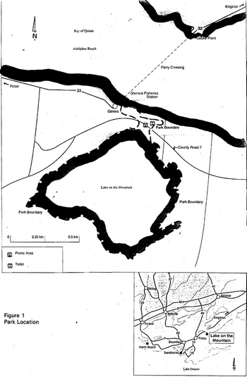
Enlarge Figure 1: Park Location
The park boundary includes the entire bed of Lake on the Mountain up to the high watermark. It also includes a 3 m (10 foot) strip along the shore of the lake on each side of ·the day use area up to the Iron Posts (IP) or Wilson Line as shown on the deed map dated Sept. 14,1922 (See Figure 2). (Contrary to a note on the park boundary map, describing a 10 foot strip around the entire lake as part of the park, only that portion described above is within the park. See Reference 3.)
In the early 1970s, the ministry negotiated to purchase the Franklin property, 1072 ha (2650 acres) surrounding most of the lake, of which 204 ha (506 acres) were for sale. A large part of the appeal of the park is its relatively natural condition, including the view of this undeveloped property seen from the lookout over Lake on the Mountain. The natural condition of the shoreline is key to ensuring the quality of the lake environment and so another reason for pursuing the acquisition was to secure water quality for the Glenora Fisheries Station. In 1973, Mr. Franklin offered the smaller parcel to the province despite offers from the private sector. Because a sale price could not be negotiated, the purchase was never completed. As of March 1994, the Land Registry Office confirms that the land is still registered to Mr. Franklin.
The park boundary also contains a very scenic parcel of land along the stream bed at the extreme east end of the day use area. This area overlooks the waterfall along the escarpment. It was part of a Crown Lease last numbered as C.L. 3658. The lease expired in December 1993 and was not renewed by the ministry. This leased land had been used by the adjoining land owner who made considerable changes to the creek bed and surrounding land. The creek bed holds a small concrete dam which forms a pool only a few feet above the seasonal waterfall.
Substantial residential development has occurred along the shore of Lake on the Mountain and in the surrounding area. Zoning changes to permit severances on lake front properties have been supported by the Township of North Marysburgh. The County of Prince Edward has denied zoning changes with the view that the area must be protected from adverse development.
Glenora Fisheries Station
The Grenora Fisheries Station is housed in a historical stone building on the waterfront of Lake Ontario, next to the Glenora Ferry landing.
The stone structure was built in 1872 as an iron foundry. In 1922 the property was purchased by the Ontario Government for use as a fish hatchery. Included in the purchase was the bed of Lake on the Mountain itself. (The boundary of this acquired property is the same as that used to describe the boundary of Lake on the Mountain park, in regulation under the Provincial Parks Act.) The waters from the lake were used for fish rearing. From 1987 to 1989 the interior of the building was completely refurbished and modernized.
The primary objective of the Glenora Fisheries Station is to monitor and conduct research on fish populations and habitat of Lake Ontario to develop scientific knowledge and assist fisheries managers. The station serves as a base for both field and laboratory research and assessment. The extensive field program evaluates fish populations and their relationships through long-term surveillance and sampling programs.
Guideline
- Lake on the Mountain will continue to be classified and managed as a Recreational Provincial Park in the Ontario Provincial Park system, providing day use opportunities for park visitors.
- Securing the scenic, aesthetic and environmental values presented by the Franklin property, and the corresponding preservation of the lake environment and water quality in Lake on the Mountain will be pursued. Acquisition will be considered if offered for sale. However, keeping these preservation objectives in mind, alternatives to direct acquisition will also followed. These include communication with the land owner and the municipality to gain support, application of the Conservation Land Tax Reduction program, securing a conservation easement, and collaborating with partners in securing the property.
- Liaison with the township and the county will be maintained in order to advise against any development of surrounding lands which would have detrimental impacts on the lake or its water quality.
- The Glenora Fisheries Station is within the park boundary. It is recommended that the Glenora Fisheries Station and associated lands be excluded from Lake on the Mountain Provincial Park, subject to the requirements of exemption order MNR 59/2, under the Environmental Assessment Act.
Figure 2: Plan of Property Conveyed in 1922
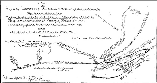
Enlarge Figure 2: Plan of Property Conveyed in 1922
First Nations
The Mohawks of the Bay of Quinte is the First Nation closest to the park. Others with possible interest are the Algonquins of Golden Lake and the Mississaugas of Curve Lake.
Guideline:
The ministry will ensure that good communication is maintained with any and all First Nations with potential interest in the park.
Natural Resources
Water quality
The lake’s water quality is an important issue. The Glenora Fisheries Station receives fresh water from Lake on the Mountain for its activities. The park, a local school and neighbouring land owners also use water from the lake. Shallow soils draining into the lake are susceptible to changes through human activity. The control of potential disturbances to the lake from adjacent run off was the reason the ministry attempted to purchase the surrounding land in the early 1970's.
Guideline:
The ministry will work with land owners, the township and others to foster awareness about potential causes of declines in water quality.
Life science features
Since 1955, there is no record of a complete lake survey for Lake on the Mountain. The lake has not been studied for its life science features either but was studied in January 1974 for nutrient enrichment. (See Reference 1.) The last surveys in the 1970s recorded angling pressures after the re-opening of the angling season which had been closed for more than 30 years. At that time, creel surveys and fish stations collected information on fish species in Lake on the Mountain. The following species were recorded in the 1970s:
Game fish: Smallmouth Bass, Largemouth Bass, Northern Pike, Lake Herring (Cisco)
Forage fish: Yellow Perch, White Perch, Rock Bass, Brown Bullhead, Pumpkinseed, Golden Shiner
Guideline:
It is recommended that a complete life science inventory be carried out for Lake on the Mountain Provincial Park, including a more detailed fisheries assessment. Partners and researchers will be encouraged to do this work.
Earth science features
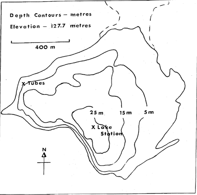
The bedrock escarpment is well developed and comparable to the Niagara Escarpment. Of particular interest is the formation of a relatively deep lake so close to the edge of an escarpment. The only other comparable lake in the county is Roblin Lake, 25 km west of the park. These 2 lakes have good scientific and educational potential and are considered to be physiographic anomalies of regional significance.
Lake on the Mountain is the only physiographic feature of its type, i.e. a collapsed doline, within the parks of eastern Ontario. There are very few opportunities to illustrate this type of feature within southern Ontario. Similar examples can be found only on the Niagara Escarpment on the Bruce Peninsula. The District Land Use Guidelines also note that "mass wasting in the form of rockslides is represented by cliffs and talus slopes" found in…Lake on the Mountain Provincial Park.
Geological interpretation covers 3 main aspects of the area: 1) the bedrock stratigraphy, 2) the glacial history, and 3) the formation of Lake on the Mountain. A regional perspective is important in interpreting the geology of this area in order to fully appreciate its features.
Guideline:
- Geology will continue to be a major part of the natural heritage education theme for Lake on the Mountain Provincial Park.
- Further research into the geological theme by qualified partners and researchers will be encouraged.
Cultural resources
The park and in particular the lake is rich in cultural resources. It was called Lake of the Gods by the Mohawks, whose legends tell of spirits dwelling within the deep waters of the lake, spirits who each spring were offered gifts to ensure successful crops.
Figure 3: Depth Contours for Lake on the Mountain
People occupied what is now Prince Edward County for several thousand years including in sequence, Laurentians, Hopewillians, Iroquois and Mississaga people. Many archaeological sites throughout the southern county reveal evidence of these people. Archaeological sites have not been identified in Lake on the Mountain Provincial Park or vicinity.
Believed by early settlers to be bottomless or leading to a distant water source Lake on the Mountain’s clear water of unknown source, has mystified people for centuries.
The natural advantages of the site were used to create milling operations which were close to good harbour facilities and major shipping routes. Glenora is rich in historical buildings, marking an important part of Ontario’s early trade. Saw mills, grist mills, woollen mills and an iron foundry all operated at Glenora. The Glenora Fisheries Station now operates from one of these original buildings. (See above.)
Guideline:
- Cultural history (First Nations, Loyalists, etc.) will continue to be a major part of the natural heritage education theme for Lake on the Mountain Provincial Park.
- Further research into cultural history themes by qualified partners and researchers will be encouraged.
Existing and proposed development
The small land base and the topography of the park restrict recreational use to day use activities.
County Road 7 divides the property at the north end of the lake, which is where the park’s day use facilities are found. On the north side of the road is a washroom and parking for 25-30 cars, serving picnic areas on each side of the road. Interpretive plaques are also in place on either side of the road, describing the geology of the park and its cultural associations. There is a short trail along the shore, and a platform overlooking, Lake on the Mountain. From the picnic area on the north side of the road, visitors enjoy a picturesque view overlooking the Bay of Quinte.
In 1993 a berm was constructed over the existing concrete dam, which had been leaking and occasionally causing flooding of County Road 7. Pillars supporting the viewing platform at the lake were recapped at the same time. This project followed procedures set out under the Class Environmental Assessment for Dams and Dykes.
The warm water intake which feeds the Glenora Fisheries station is located under the viewing platform. A feeder from this line supplies the park’s water. In 1994, work was undertaken by Management Board Secretariat to fix leaks in the warm water intake lines.
The cold water intake valve is at the creek outlet east of the platform. The plastic pipe leads from the creek outlet at the lake and disappears underground running parallel to the lake and continues through a culvert under the road together with the warm water intake line. The two lines then follow separate routes to the research station.
In 1993, surveys of the stone wall along the escarpment were done. The wall is in danger of collapse. Holes are evident in the ground along the fence line and the fence itself is leaning considerably inward. The problem is a safety issue. One option proposed by engineers following the survey, was to fill along the base of the wall with rock. (It should be noted that the natural rockslide or talus slope, at the base of the escarpment is a noted earth science feature.)
In 1993, the resident west of the day use parking lot proposed a link with the park’s water main which is located approximately 30 m (100 feet) east of the boundary with this property. The purpose was to supply water year-round to this private home, which is without a well, at a reasonable cost. This proposal was approved and completed in 1993. All associated costs were covered by the land owners. Negotiations continue with the owners to grant them an easement to the water main connection in exchange for a right-of-way on the Mountain Road which after cutting across a corner of the park, leads across their property and down the escarpment to Glenora. This is an historic link which could be easily restored.
Guideline:
- There is an urgent need to repair the unsafe retaining wall along the escarpment. Engineering plans will be drawn up and funding requested to complete the necessary work.
- Negotiations with the land owners who have interest in the Mountain Road should continue in order to secure a right-of-way for park use. This would allow for planning and development of a trail linking the park and the community of Glenora.
- Plans will be developed to make best use of the former Crown lease property, at the east end of the day use area. This area overlooks a concave erosion of the escarpment creating a spectacular seasonal waterfall. It is an attractive but currently hazardous site for the public to use. The area will be planned to safely allow park visitors to view and learn about this waterfall.
Recreational activities
Lake on the Mountain Provincial Park provides impressive scenic views of this mysterious lake perched atop the escarpment and overlooking the Bay of Quinte and the Glenora Ferry route.
There is no hunting allowed in the park. Canoeing, boating and fishing are allowed but without the use of motor boats. There is no official boat launch and camping is not allowed. Swimming is not encouraged within the park. Most visitors enjoy the park’s day use facilities for rest, relaxation, picnicking and scenic viewing and photography.
Some recreational use of the lake comes from private land owners pursuing swimming, rowboating, sailing and fishing activities.
No fees are collected for use of the park.
Guideline:
- The current management of recreational activities at Lake on the Mountain Provincial Park is appropriate. Hunting, trapping and camping will continue to be prohibited.
- It is recommended that the wording of Regulation 952 of Revised Regulations of Ontario 1990 (Provincial Park Regulations) Section 27 (1) (r) be changed from Lake on the Mountain Provincial Park Picnic Grounds to Lake on the Mountain Provincial Park. This may avoid legal challenges regarding the use of motorboats on the lake which is now and should continue to be prohibited.
- Methods, such as parking fees, will be explored and used where appropriate, to create revenues for the park’s operations.
Client services
The park is a self use operation, providing picnicking and interpretive displays. Interpretive displays explain the geological significance of a collapsed doline very close to an escarpment. Heritage appreciation focuses on legends linked with the formation of Lake on the Mountain and on the history of the United Empire Loyalists settlement in this area. The full colour 1992 park leaflet provides brief description of these features.
Guideline:
- The park will continue to provide basic information and self use facilities. A small booklet should be produced to present a complete package of interpretive information on the park, to be made available at local businesses and schools. Local organizations or the Friends of Sandbanks could be encouraged to collaborate on this booklet.
- Park staff will work with school boards, teachers and other group leaders to encourage increased use of the park and to foster an appreciation of the natural and cultural resources of the park. The focus will be on the park’s interpretive themes as outlined above.
References
- Christie, A. E. Ontario Ministry of the Environment, Research Branch. Research Report W 48 - Nutrient Enrichment Studies in a Marl Lake, Lake on the Mountain, Prince Edward County. Unpublished report. January 1974.
- Department of Indian Affairs and Northern Development. The Indians of Ontario (A Historical Review). Ottawa. 1966.
- Department of Lands and Forests, Division of Surveys and Engineering, Gilbert E. Ward, Ontario Land Surveyor. Plan Showing The Glenora Fish Hatchery Property. File 136507. Toronto. June 20, 1952.
- Hassard, Albert R. The Lake on the Mountain. 1916.
- Ontario Ministry of Consumer and Commercial Relations. Land Registry Office for the County of Prince Edward. Instrument Number 4194. Deed of Land. 1922.
- Ontario Ministry of Government Services. New Water Supply, Site Plan, Fish Hatchery Glenora. File Number M 1513·1 and M 1513-2. January 1976.
- Ontario Ministry of Natural Resources. Dissolved Oxygen, Limnology Data: Lake on the Mountain. Glenora Fisheries Research Station. Glenora. 1969-70.
- Ontario Ministry of Natural Resources. Lake on the Mountain Provincial Park: A Position Paper. Unpublished paper. Napanee. 1985.
- Ontario Ministry of Natural Resources. Lake on the Mountain Provincial Park leaflet. North York. 1992.
- Ontario Ministry of Natural Resources. Napanee District Land Use Guidelines. Publication Number 5884. Napanee. 1983.
- Ontario Ministry of Natural Resources. Ontario Provincial Parks Statistics. Publication Number 5628. ISSN 0704-2094. North York. 1992.
- Ontario Ministry of Natural Resources. Plan of lake on the Mountain Provincial Park. File: 136507. Toronto, Surveys and Mapping Branch. 1973.
- Ontario Ministry of Natural Resources. Provincial Park Day-Visitor Survey for lake on the Mountain. Unpublished report. Toronto. 1982.
- Ontario Ministry of Natural Resources. Unpublished file material at the Tweed and Napanee offices. Various dates.
- Picton Times Centennial Souvenir Edition. Newspaper clippings: lake on the Mountain - Notes on Historical Background. 1937.
- Pile, D. District Naturalist, Department of Lands and Forests. Archaeological Research on Prince Edward County. Unpublished Tweed. 1972.
- Revised Statutes of Ontario. Chapter P. 34 & Regulation 822 of Revised Regulations of Ontario. Provincial Parks Act and Regulations. 1990.
- Turner, Larry. Ontario Ministry of Natural Resources. History of lake on the Mountain and Glenora. Unpublished report. Napanee. 1974.
- Various authors. lake on the Mountain legends and Mysteries. 1937-1978.
- Woerns, Norbert. Earth Science Inventory Checklist - Lake on the Mountain, Ontario Ministry of Natural Resources. Unpublished document. 1977.