Larder River Provincial Park Management Plan
This document provides policy direction for the protection, development and management of Larder River Provincial Park and its resources.
© 1998, Queen’s Printer for Ontario
Copies of this publication are available from the Ministry of Natural Resources at the following locations:
Kirkland Lake District Office
Larder River Provincial Park, Park Superintendent
Box 129
Swastika, ON P0K 1T0
(705) 642-3222
Ontario Parks
199 Larch Street, Suite 404
Sudbury, ON P3B 5P9
4162-1
(0.1 k, PR, 980727)
ISBN 0-7778-5633-6
Cette publication est egalement disponible en francais.
Approval statement
I am pleased to approve the Larder River Provincial Park Management Plan, as the official policy for the management and development of this park. The plan reflects this Ministry’s intent to protect natural and cultural features of Larder River Provincial Park and maintain high quality opportunities for outdoor recreation and heritage appreciation for residents of and visitors to Ontario.
The plan also reflects Ontario Parks' new financial flexibility and ability to retain revenue. Economic development opportunities can be considered that focus on the park’s special features and recreational potential.
The Larder River Provincial Park Management Plan will stand for 20 years. It will be reviewed as the need arises.
Norm Richards
Ontario Parks
Managing Director
1.0 Introduction
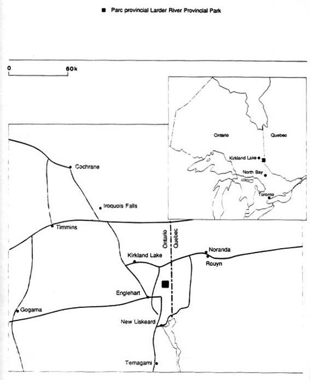
Larder River Provincial Park is a 2, 510 hectare waterway class park located in northeastern Ontario, southeast of Kirkland Lake along the Ontario-Quebec border (Map 1). The area was regulated under the Provincial Parks Act Ontario Regulation 493/85, on October 4, 1985. It lies within the Ministry of Natural Resources' Kirkland Lake District of the Northeast Administrative Region.
Larder River Provincial Park is accessed from the north via the Raven Lake access road, which extends 8 kilometres south from Highway 66. In the south, the park is accessed via roads extending east from Highway 659. There are access zones on Clear, Wendigo, and Skeleton Lakes.
The park encompasses a series of elongated lakes that flow through a northeasterly oriented fault system. It is bounded by the impressive scenery of the boreal forest, cliffs, outcrops and plateaus. The Larder River area is a popular recreation destination for canoeing, motor boating, hunting, angling and camping for northern Ontario residents and the 120 cottage owners on Raven, Wendigo and Skeleton Lakes.
Detailed information on the resources and uses in the park is assembled in the Larder River Provincial Park Background Information Binder (1992). It is available for review at the Kirkland Lake District Office.
2.0 Summary of significant issues
2.1 Future use of clear lake campground
Prior to regulation of the Larder River as a provincial park, the access point at Clear Lake developed into an unofficial tent and trailer campground for a small group of traditional local users. The majority of these individuals were residing at the Clear Lake site from May to August and were commuting to surrounding areas for work. Over the years, seasonal and weekend camping was increasing. On-site facilities were inadequate for the number of campers. Several options for managing this site were considered and these were discussed with campers to develop a mutually acceptable solution. (Refer to Appendix III and Section 9.3)
2.2 Unregulated camping at access zones
Some unregulated camping was occurring at access zones at the north end of Clear, Wendigo and Skeleton Lakes. An increase in both the distribution and number of campsites has occurred over the years, especially as the occupancy of Clear Lake campground reached its capacity. Associated concerns include an increase in garbage, poorly maintained sites, and health and environmental problems.
The park boundary will continue to include the access zone at the south end of Clear Lake (Al). (Refer to Appendix III and Section 9.3)
2.3 Proposal for aquaculture venture
As part of the Community Fisheries Involvement Program (C.F.I.P.), the Ministry of Natural Resources issued a Land Use Permit in 1987 for the construction and operation of two rainbow trout rearing ponds on Raven Lake. The operation was within the boundary of the park immediately adjacent to Lot 11, Reg. M-Plan 236, McFadden Township. The proponent expressed an interest in withdrawing from the C.F.I.P. and elevating the land tenure to a Crown lease for the purpose of rearing fish commercially. Analysis of the request, and the associated public consultation were in accordance with the Ministry’s land management policies.
The park boundary will continue to include the 1.04 hectares immediately adjacent to Lot 11, Plan TEM 236, McFadden Township (Map 2) so that the aquaculture facility is accessible. Appendix II provides a chronology of this issue, including the evaluation and public consultation process that resulted in the Ministry’s decision to close the facility.
2.4 Use of large power boats on Clear Lake
Clear Lake is a small water body that has traditionally been used for a variety of water-based recreation activities (e.g. power boating, water-skiing, canoeing, angling, swimming etc.). There is potential for conflict between users of large power boats and other recreational users, as well as potential for water quality degradation. Canoeists, owners of small watercraft and swimmers have expressed concern regarding their safety. (Refer to Section 9.3.1)
Map 1: Regional Setting
Enlarge Map 1: Regional Setting
2.5 Hunting on the Clear Lake road
Hunting may be permitted in natural environment zones of waterway class provincial parks, if supported through public consultation in the planning process. Previous stages of public consultation indicate that there is a lack of consensus around hunting. Many supported hunting in the park, including the Clear Lake road corridor, providing there was no conflict with other recreational users. (Refer to section 8.4)
2.6 Commercial trapping
A group requested to have the phase-out of commercial trapping raised as an issue. The group is not in favour of implementing any restrictions on commercial trapping in the park. The group indicated that commercial trapping is only effective for managing nuisance animal populations. (Refer to Section 8.4)
2.7 Aboriginal land claim
The Beaver House Band may be preparing background information for a land claim covering 17 Townships including McFadden, Rattray, Hearst and Skead as part of their traditional harvesting areas. The strategy for resolving the land claim issue is beyond the scope of this planning exercise. Refer to Section 8.4 for policies dealing with Aboriginal Treaty Rights.
3.0 Classification
Larder River Provincial Park is a waterway class park and is managed in accordance with the Ontario Provincial Parks Planning and Management Policies, (1992). The definition for this class of park is:
"Waterway class parks in corporate outstanding recreational water routes with representative natural features and historical resources to provide high quality recreational and educational experiences."
The Larder River chain is an outstanding recreational water route surrounded by a rugged scenic landscape of forested, rock-dominated topography (refer to Section 7.0).
4.0 Goal
The goal of Larder River Provincial Park is:
To protect the outstanding landscape and significant natural and cultural resources of Larder River Provincial Park and to provide opportunities for compatible water-based recreational, educational and scientific activities.
5.0 Objectives
Larder River will contribute to all four objectives of the Ontario Provincial Parks system including protection, recreation, heritage appreciation and tourism.
5.1 Protection
To protect provincially significant elements of the natural, recreational and cultural landscape of Larder River Provincial Park.
The Larder River will protect a representative portion of the ancient geological history , modern biological environments and cultural features associated with Kirkland Lake Site District of the Abitibi Site Region 3E and portions of the New Liskeard Site District of the Lake Temegami Site Region 4E'. Significant geological and biological features that are protected within the park are described in Sections 5.3 and 7.0.
The primary management objective for the park is to protect the park’s waterway environment for the benefit of future generations without compromising the needs of existing users.
5.2 Recreation
To provide a diversity of river recreation opportunities in a natural setting.
The interior waterways (Ward Lake, Larder River, Skead and Upper Wendigo Lakes) provide an easy two to three day back-country canoe route with several set s of rapids and falls. Wendigo, Skeletonpup, Skeleton, Clear and Raven Lakes are popular with local users and cottage owners for angling, motor boating, swimming, hunting and snowmobiling. People within the Region may be attracted to this park.
The management direction for the park will ensure that back-country and traditional recreation uses continue within the capacities of the park’s resources.
In classifying Ontario’s natural heritage, the province is divided into 14 Site Regions, which are subdivided into 65 Site Districts. A Site District is an area in which the interrelationship between vegetation and the landform are uniform throughout the area The Kirkland Lake Site District is an area of Moderately broken plains of granitic and low-base bedrock generally thinly coveted with granitic and low-base sand and silty sand (Hills, 1959).
5.3 Heritage appreciation
To provide opportunities for unstructured, individual exploration and appreciation of the natural and cultural heritage of Larder River Provincial Park.
There will be no formal heritage education program at Larder River Provincial Park. The natural and cultural features of the park are best enjoyed by unstructured exploration.
More than 80% of the shoreline geology consists of rocks from the Early and Middle Precambrian Age. The outcrops are found in a series of northeasterly oriented ridges consisting of escarpments, plateaus and bluffs. The Larder River was once a drainage channel for the glacial Lake Barlow Ojibway and its channels transported materials from the Boundary Esker. A number of these outwash deposits are found along the river system. The Boundary Esker is oriented in a north-south direction and extends north of Raven Lake along the southwest side of the Larder River to Clear Lake.
The park lies within the central and southern boreal forest regions as defined by Maycock (1979).
The fauna of the park is typical of the boreal forest. The pygmy shrew, water shrew and yellow-nosed vole have been collected in several localities near Larder Lake. Suitable habitat is found in the park for the provincially significant pygmy shrew. Suitable breeding habitat also exists for sixty-four species of birds, including the regionally rare great-horned owl (Bubo virninianus), mourning dove Zenaida macroura and pine grosbeak (Pinicola encleator).
Walleye, smallmouth bass, yellow perch and white sucker are present in Skead and Ward Lakes. Lake trout, northern pike, lake whitefish, burbot and cisco are present in Raven and Wendigo Lakes.
There are several known prehistoric Aboriginal archaeological sites within the park dating from 200 BC. The Larder River was traveled in 1686 by Chevalier De Troyes, leader of a French military expedition, to conquer English fur trading posts on James Bay. The River was part of the initial geological survey of 1901 and the Larder Lake gold rush of 1906.
5.4 Tourism objective
To provide tourism services for visitors to Larder River Provincial Park.
There is potential for seasonal services, for park visitors, to provide food and beverage and recreational equipment rental at access points.
5.5 Consideration of MNR's Statement of Environmental Values under the Environmental Bill of Rights
The Ministry of Natural Resources (MNR) is responsible for managing Ontario’s natural resources in accordance with the statutes, which it administers. As the Province’s lead conservation agency, the Ministry of Natural Resources is the steward of provincial parks, natural heritage areas, forests, fisheries, wildlife, mineral aggregates, fuel minerals, and Crown lands and waters which make up 87% of Ontario.
The Ministry of Natural Resources is committed to ecological sustainability, as endorsed by the World Commission on the Environment and Development.
In 1994, the Ministry of Natural Resources finalized its Statement of Environmental Values (SEV) under the Environmental Bill of Rights. The Statement of Environmental Values is a document which describes how the purposes of the Environmental Bill of Rights (EBR) is to be considered whenever decisions that might significantly affect the environment are made in the Ministry.
The Ministry’s SEV is based on sustaining the provinces ecosystems. The Ministry has taken this approach to its SEV because sustainable development is compatible with the purposes of the EBR.
The park management policies presented in this plan were developed with full consideration of the Ministry’s Statement of Environmental Values.
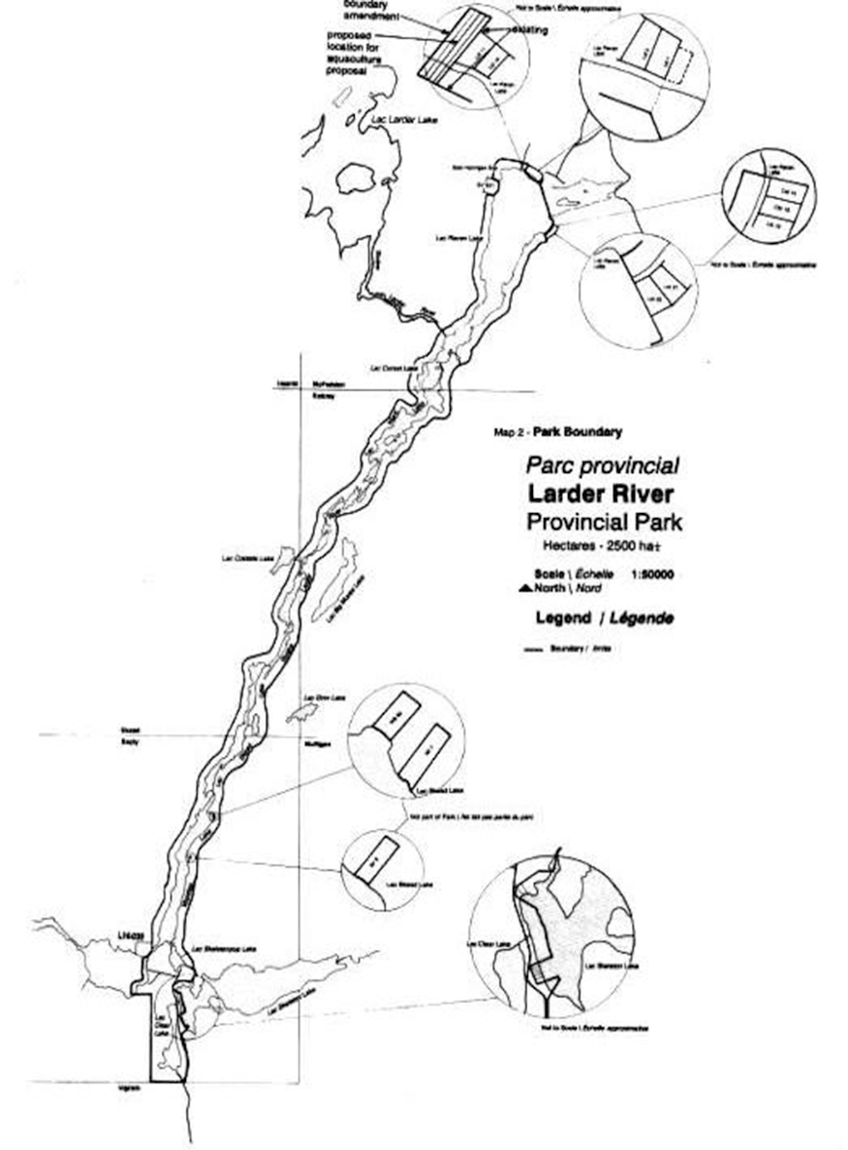
6.0 Park boundary and land tenure
The existing park boundary extends from Raven Lake to Clear Lake and includes a 200 metre shoreline strip from the high water mark on both sides of Raven Lake, Corset Lake, Ward Lake, Larder River, Skead Lake and Upper Wendigo Lake. It includes the node of land surrounding Skeletonpup and Clear Lakes, bordered by Wendigo and Skeleton Lakes (Map 2).
Patent lands located along Upper Wendigo Lake (WB6O, RF7 and RF8) surrounded by the park boundary are not included in the park. All patent land including cottage subdivisions on Raven, Wendigo and Skeleton Lakes and patent mining claims on Raven and Wendigo Lakes are also not included within the park. Landowners are not restricted in the sale or transfer of private land. The use of private lands will continue to be regulated by the existing jurisdictions. The Ministry of Natural Resources will continue to encourage the conservation and management of natural resources through participating in plan input and review of development proposals on patent lands.
In accordance with provincial park policy, the Ministry may acquire patent lands (WB60, RF7, and RF8). As long as the surface and mining rights of these claims are under private ownership, mining activities can proceed on them.
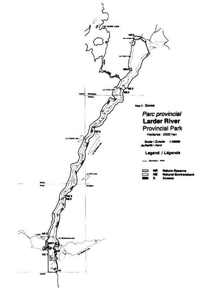
7.0 Zoning
Lands and water in Larder River Provincial Park have been zoned on the basis of the natural, cultural and recreational resources in each area.
Three zones will be used to guide the management of Larder River Provincial Park including nature reserve, natural environment and access zones (Map 3).
The following section describes each zone. Tables 1 and 2 list the recreational activities and facilities, and resource uses permitted in each zone. Other recreational uses may be permitted or prohibited in a manner consistent with the planning and management policies for waterway parks (OMNR, 1992). Uses and facility development will be subject to the standard legislation and policies governing provincial parks as well as policies presented in Sections 8,9 and 10 of this Management Plan.
7.1 Nature reserve zones
Nature Reserves include any significant earth and life science features, which require management distinct from that in adjacent zones, as well as a protective buffer with an absolute minimum of development.
NR1 Lower Wendigo shoreline (7.7 ha)
This zone represents narrow bands of vegetation along the river edge. A narrow strip of sand dominated by sedge ~ occupies the lowest level. Sweet gale (Myrica gale) dominates the next band along with the occasional eastern white cedar (Thuja occidentalis and the largest population of the Provincially rare Clinton’s club-rush (Scirntus clintonii in the park. A dense area of speckled alder (Alnus incana ssp. rugosa), black ash Fraxinus nigra), eastern white cedar, mountain holly (Nemopanthus mucronatus , winterberry and other shrubs and saplings complete the habitat. This zone also contains three regionally rare plants, which are listed in Appendix V.
A trail passes through this zone joining Wendigo Lake Access Zone (A2) with Swift Water Rapids. The trail was used in the past by Aboriginal People, trappers and loggers. Use of this trail for activities will require detailed site planning for the trail. Related policies are in Section 102.
NR2 Upper Wendigo Lake Jack Pine Forest Complex (36.6 ha)
This zone protects a representative example of a jack pine (Pinus banksiana) forest community known to occur in Site District 3E-6 and is considered provincially significant. The area is relatively undisturbed and contains eight regionally rare species of plants which are listed in Appendix V.
Eastern white cedar dominates the first 7-10 metres from the shoreline, then gives way to a mixture of stunted mature jack pine, white pine (Pinus strobus), red pine (Pinus resinosa and associated species. Jack pine dominated near the top of the 80 metre high valley slopes. The slopes are composed of exposed bedrock of volcanic origin and are thinly covered with glacial drift.
NR3 Larder River Rapids and Wetland Complex (12.7 ha)
Located at the base of a set of rapids on the Larder River, this zone protects an unusual and diverse aquatic community composed of rushes (Juncaceae family), pondweeds and water lilies (Nymphaeaceae family). The area is considered provincially significant within Site District 3E-6.
Map 2: Park Boundary

Map 3: Zones
Table 1: Recreation activities and facilities and facilities
| Activities and facilities waterway parks | Park Zone NE | Park Zone D | Park Zone WI | Park Zone NR | Park Zone HI | Park Zone A |
|---|---|---|---|---|---|---|
| All-Terrain Vehicle (A.T.V.) Travel | decided during park management planning | decided during park management planning | decided during park management planning | decided during park management planning | decided during park management planning | decided during park management planning |
| Aircraft Landing (water) - commercial tourism | M | M | M | |||
| Aircraft Landing (water) - private | M | M | ||||
| Boating (powered) - commercial | M | M | M | M | M | M |
| Boating (powered) - private | M | M | M | M | M | M |
| Campgrounds - car | Y | |||||
| Campgrounds - boat-in/walk-in | M | M | ||||
| Campgrounds - group | M | M | ||||
| Campgrounds - back-country | Y | M | ||||
| Canoeing/kayaking | Y | Y | Y | M | Y | Y |
| Demonstration areas (e.g. Logging exhibits…) | Ma | |||||
| Hiking | Y | Y | Y | M | M | Y |
| Historical appreciation - self-guided | Y | Y | Y | M | M | M |
| Horseback riding - trail | M | M | M | M | ||
| Mountain biking-designated trails | M | M | ||||
| Nature appreciation-self-guided | Y | Y | Y | M | M | Y |
| Orienteering | Y | Y | Y | M | M | Y |
| Outfitting service | M | M | ||||
| Outpost camp (commercial) | M | M | ||||
| Painting/photography | Y | Y | Y | M | M | Y |
| Picnic grounds | Y | M | Y | |||
| Playgrounds | M | |||||
| Recreation programs (organized) | M | |||||
| Resorts/lodges | M | Ma | ||||
| Restaurants-food & beverage | Y | Ma | M | |||
| Rock climbing | M | M | M | M | ||
| Sailing and sailboarding | Y | Y | M | M | M | M |
| Scuba and skin diving | M | M | M | M | M | M |
| Skiing (cross-country)/snowshoeing | Y | Y | Y | M | M | Y |
| Snowmobiling | M | M | M | |||
| Spelunking (cave exploration) | M | M | M | M | ||
| Sport fishing | Y | Y | Y | Y | Y | Y |
| Sport hunting | decided during management planning program | decided during management planning program | decided during management planning program | decided during management planning program | decided during management planning program | decided during management planning program |
| Swimming-facility based | Y |
Legend
Y: Normally encourage in this zone
M: May be encouraged in this zone in certain parks where deemed appropriate
Blank: Not compatible with this zone; if now existing, a non-conforming use to be phased out
Ma: May be encouraged if authentic to the historical zone
NR4 Raven Lake Ring Bog (2.9 ha)
This zone protects a ring bog on the west side of Raven Lake. This is the most extensive and diverse bog in the park. It is the best example of a ring bog in site district 3E-6 and is considered provincially significant. The bog’s vegetated mat is dominated by sphagnum, leatherleaf (Chamaedaphne calvculata) and small cranberry Vaccinium oxycoccos ) is completely surrounded by a moat of water. Rose pogonia (Pogonia ophioglossoides) and large cranberry Vaccinium macrocarpon) are two regionally rare plants that occur here. River otter and moose (Aim alces ) habitat exists in this bog.
NR5 Hannigan Bay Wetland and Upland Complex (22.0 ha)
Located on the shallow sandy shores of Hannigan Bay on Raven Lake, this zone represents the largest wetland in the park. It is considered to be the most important aquatic community in the park and is provincially significant. Four regionally rare species grow here (Appendix V). Submerged plants like water-milfoil (Myriophyllum spp.) and pondweed extend 35 metres from the shore. Common cattail (Typha latifolia) , sedge and rushes occur along the shoreline. A winter moose yard is located about one kilometer upstream from Hannigan Bay. The bay is rated as very high for potential moose feeding habitat. The bay has excellent cover for fish and surfaces for spawning which contribute to fish viewing opportunities. Picnic tables and privies are located in the beach area. Day-use policies are found in section 10.3. An aquaculture facility was operated adjacent to the wetland but was closed as of 1995. (Refer to Appendix II)
7.2 Natural environment zones
Natural environment zones are natural, cultural or aesthetic landscapes in which minimum development is required to support low-intensity recreational activities.
NE1 Clear Lake and Portion of Skeleton Lake (232.8 ha)
Zone NE 1 will be managed to support low-intensity waterbased recreation activities. This zone includes Clear Lake, most of the surrounding node of land and a small portion of Skeleton Lake. The Clear Lake Plateau located at the northwest end of the lake possesses regionally significant forest communities. Red maple (Acer Rubrum) saplings and small trees are found on top of the plateau, as are fifteen regionally rare plants (Appendix V). A short trail extends from the public parking area on the east side of Clear Lake (A3) to the plateau to provide an impressive view of the Lake. See section 9.3 (Other) for related policies.
NE2 Skeleton pup, Wendigo and Raven Lakes (1,121.2 ha)
This zone contains a number of significant earth and life science features. Eighty metre high cliffs near Skeletonpup Lake face southwest giving them a warmer than normal microclimate. A white spruce (Picea glauca), white birch (Betula papyrifera), 60 metre high cliffs occurs on the west shore of Raven Lake. These cliffs are east facing and therefore colder than normal. Three hundred year old eastern white cedar grow adjacent to the Raven Lake Ring Bog. Black ash (Fraxinus nigra) found at its northern limit here. Many Regionally rare plant species occur in this zone (Appendix V).
This zone is adjacent to a number of cottages (approximately 43 on Raven Lake and 61 on Wendigo). It will be managed to support moderate intensity day-use water-based activities.
NE3 Skead, Ward and Corset Lakes and Larder River (1,045.6 ha)
This zone protects the natural landscape and aesthetic splendour of the Larder River corridor. The interconnecting lakes, rapids, portages and back-country campsites offer a semi-wilderness canoeing experience. Red pine is found at its northern limit in this zone. Regionally significant vegetative communities occur on an unnamed island in Ward Lake. One regionally rare plant, Yellow-eyed grass (Xyris montana), was found on the bog mat surrounding an unnamed lake (Appendix V). Zone NE3 will be managed as an interior canoe route supporting low-intensity recreational water travel.
7.3 Access zones
Access to the park is described as follows:
Access zones serve as staging areas where minimum facilities support the use of the less developed natural environment zones and nature reserve zones. Section 10 presents the related development policies for these zones.
Al Raven Lake Crown Access Point
Access to the north end of the park is via the Raven Lake Crown Access Point. This area is outside the park boundary; therefore it is not identified as an access zone in this Management Plan. See section 9.3.2 for policies related to accessing the park.
A2 Wendigo Lake Access Zone (10 ha)
This area is used as a campsite by visitors starting or completing the canoe route and as a parking area for those participating in day-use activities on Wendigo Lake. The zone is large enough to accommodate limited parking. Facilities include a boat launch ramp. Policies related to camping in this access zone are found in sect ion 9.3.
A3 Skeleton Lake and north end of Clear Lake Access Zone (7.0 ha)
There is a clearing opposite Skeleton Lake that is used by day visitors to park their boat-trailers and vehicles and for overnight parking by owners of cottage lots in the Registered M-Plan 251. At present there is no other access or parking for these cottage lots. Facilities include a boat launch ramp.
A4 Skeletonpup Lake Access Zone (3.0 ha)
This is an area at the end of the Clear Lake road that is used to access Skeletonpup Lake. There are no facilities.
8.0 Resource management policies
The park will be managed in accordance with the general planning and management policies for waterway class provincial parks (Ontario Provincial/Parks: Planning and Management Policies, 1992) and the Ontario government Cabinet-approved policies for provincial parks (1989). Direction is provided below to meet specific resource management requirements.
Although individual resource policies are described under a series of separate headings, all planning and management will recognize that these components are highly interdependent. An integrated approach to resource management will be required to achieve park objectives.
8.1 Lands and water
Mining
New mining activity, including prospecting, staking of mining claims, development of mines or the extraction of aggregates is not permitted in the park.
The Ministry will assess and monitor mining interest on Crown land adjacent to the park boundary on a case-by-case basis. Efforts will be made to protect park values that might be impacted by such developments (e.g. water quality, skyline view, noise, etc.) using existing legislation and regulations.
There are two patent mining claims (L 16031 and SV52 1) adjacent to the park boundary, which will be acquired as funds permit and as owners are willing to sell. The Ministry will attempt to communicate the nature of the park’s values and the need for their protection to claim holders.
Hydroelectric development/water control structures
Commercial hydroelectric development is not permitted in the park. Any proposed development outside the park, which could potentially affect park values, will be dealt with on a case-by-case basis with the proponent and interested stakeholders.
The remnants of a power station operated between 1930 and 1940 at the eastern and western outlets of Raven Lake will be allowed to deteriorate naturally. A newer concrete weir was built upstream from the power station in 1960. This dam is set at a fixed elevation to maintain water levels on Raven Lake for existing cottagers. This weir receives no maintenance.
A second dam is located outside the park on the Larder River. It regulates water levels on Larder Lake and lakes within the park. This dam was originally constructed in 1916 but was rebuilt in 1959 after a flood washed it out. Access to the dam for operation and maintenance purposes is via water from the Town of Larder Lake. Maintenance and operations of the dam are currently being contracted out. Water levels are determined in consultation with the Town of Larder Lake and the Wendigo-Bayly Lakes and Raven Lake cottager groups.
No new water control structures are permitted in the park.
Crown land occupations/private recreation camps
No land disposition for the private use of individuals or businesses will be permitted in the park (refer to Section 9.5).
8.2 Vegetation management
Adjacent Timber Operations
Commercial timber harvesting is not permitted in the park, however harvesting will occur in the adjacent Temiskaming Crown Management Unit.
Table 2: Resource Management Policies
Resource management policies-wilderness parks
| Lands and waters | Park Zone D | Park Zone A | Park Zone WI | Park Zone NR | Park Zone HI | Park Zone NE |
|---|---|---|---|---|---|---|
| Mineral Exploration and Extraction | ||||||
| Aggregate Extraction | ||||||
| Commercial Hydro Development | ||||||
| Water Control Structures (new) | Y | Y | M | M | Y | |
| Land Disposition - private camps | ||||||
| Land Disposition - commercial outpost camps, lodges | M | M | Ma | M |
| Flora | Park Zone D | Park Zone A | Park Zone WI | Park Zone NR | Park Zone HI | Park Zone NE |
|---|---|---|---|---|---|---|
| Vegetation Management | Y | Y | M | M | M | Y |
| Commercial Logging | ||||||
| Insect/Disease Suppression: native | Y | M | M | M | ||
| Insect/Disease Suppression: non-native | Y | M | Y | Y | Y | Y |
| Fire Suppression: natural | Y | Y | M | |||
| Fire Suppression: human-caused | Y | Y | Y | Y | Y | Y |
| Prescribed Burning | M | M | M | M |
| Fauna | Park Zone D | Park Zone A | Park Zone WI | Park Zone NR | Park Zone HI | Park Zone NE |
|---|---|---|---|---|---|---|
| Commercial Trapping | Status Indians only | Status Indians only | Status Indians only | Status Indians only | Status Indians only | Status Indians only |
| Wildlife Population Management | M | M | M | M | M | M |
| Bait Fishing | M | M | M | M | M | |
| Fish Stocking: native species | Y | Y | Y | |||
| Fish Stocking: non-native species | ||||||
| Fish Habitat Management | Y | M | M | M | M | Y |
| Recreation management | Park Zone D | Park Zone A | Park Zone WI | Park Zone NR | Park Zone HI | Park Zone NE |
|---|---|---|---|---|---|---|
| Commercial Tourist Operations: new | decided through management plan | decided through management plan | decided through management plan | decided through management plan | decided through management plan | decided through management plan |
| Commercial Tourist Operations: existing | M | M | ||||
| Restrictions on vehicles, aircraft, motor boats: private | M | M | Y | Y | Y | M |
| Restrictions on vehicles, aircraft, motor boats: commercial | M | M | M | Y | Y | M |
| Can and Bottle Restrictions | M | M | M | M | ||
| Party Size and restrictions and access quotas | M | M | M | M | M |
Legend
Y: Normally encourage in this zone
M: May be encouraged in this zone in certain parks where deemed appropriate
Blank: Not compatible with this zone; if now existing, a non-conforming use to be phased out
Ma: May be encouraged if authentic to the historical zone
During the development of forest management plans, on adjacent lands, protection of park values will be a primary consideration in determining harvesting and renewal activities in areas adjacent to the park. All known park values will be identified in forest planning exercises.
The following modifications to timber operations will be incorporated into the Temiskaming Forest Management Unit Forest Management Plan (formerly called Timber Management Plan). Specific details will be described in the plan and will be reviewed by the public during its preparation.
- An "Area of Concern" (A.O.C.) is a planning tool used to identify specific values which may be impacted by forest management practices. Impacts on specific park and adjacent values are considered and mitigation methods identified if forest operations are proposed in the vicinity of the park. An O.C may be a waterway, wetland or any other value that has significance. Areas of Concern of varying width will be designated adjacent to the park. For the Area of Concern, the Temiskaming Forest Management Unit Forest Management Plan will outline the method of harvest, site preparation options, site limitations and species expected to be regenerated. A variety of harvesting and renewal options will be used to ensure that a diversity of forest species and age classes is maintained
- The size of individual cut over areas adjacent to the park will be regulated by the application of habitat guidelines for moose, marten and pileated Due consideration will be given to natural disturbance patterns and biodiversity objectives. Emphasis will be placed on dispersing cuts to maximize spacing between them
- Scenic hillsides beyond the park boundary may be protected by varying methods of harvest and leaving skyline reserves
- All season (gravel) forest access roads will be located with the intention of preventing unplanned access to the park, while retaining flexibility for forest management Minimum distances for roads, including tertiary roads, from the park boundary will be prescribed in the Temiskaming Forest Management Unit Forest Management Plan. Road locations will be carefully reviewed by park and forest management staff
- Aerial herbicide applications may be undertaken adjacent to the Larder River Provincial Park boundary prior to June 1 and after August 15. The intervening period is considered the period of peak park Existing guidelines will be used to develop detailed directions on the type of herbicide to be applied and in what locations
- When prescribed burning is proposed adjacent to the Larder River Provincial Park, prescriptions for protecting park values will be considered (e.g. accurate field marking of park boundary, scheduling the burn after peak park use ends in mid-August)
When the Temiskaming Forest Management Plan is renewed, Parks and District Area Teams will review the above modifications to timber operations. If necessary, they will be altered or enhanced to ensure continued protection of park values and adjacent resource values.
Biodiversity
Larder River Provincial Park will play an important role in conserving biodiversity. In the Kirkland Lake District, the landscape has been altered by various land uses and natural disturbances such as fire, insects, disease and tree blowdowns.
Commercial timber harvesting includes cutting stands of trees when they have reached maximum size but are not yet in declining health. Larder River Provincial Park will contribute to biodiversity by retaining representative natural vegetation along the river such as mature and late successional stands of trees. Harvested stands are often converted to merchantable species. In the park, where timber harvesting is not allowed, stand conversions will occur through natural processes including natural succession. The end result will be a forested area with a large variety of species, age classes and distribution. Larder River Provincial Park, for example, lies in a transition zone between the Great Lakes. St. Lawrence forest and the boreal forest. Stands containing white and red pine or black ash, which are reaching the northern continuous limit of their range, will continue to enhance the biodiversity value of the park.
Forest fires
Natural fires will be suppressed. The irregular and generally narrow configuration of the park boundary would make it difficult to allow wildfires to burn undisturbed without risking adjacent resource values.
Management and protection priorities relating to the use of fire, fire prevention, and suppression activities in and adjacent to Larder River Provincial Park will be identified in the Regional Fire Management Strategy
Insects and disease
Forest insects and disease within the park, which threaten park values or values outside the park, will be controlled where necessary and feasible. Biological methods will be implemented. In nature reserve zones, forest insects and disease will normally be allowed to develop undisturbed.
Vegetation management
Non-native plant species, including Purple Loosestrife and Eurasian Milfoil, will not be intentionally introduced into the park. If a non-native species becomes established and threatens park values, an eradication program will be developed and implemented by the Ministry of Natural Resource. Missing native plant species may be reintroduced if biologically feasible to rehabilitate deteriorated areas. Trees in the park may not be cut for fuelwood by campers or by local fuelwood operators.
If funds are available, populations of the provincially rare Clinton’s Club-rush in Lower Wendigo Shoreline (NR1) and in other locations of the park will be monitored on a five year basis to assess their status. This was recommended in the Biological Inventory (1992).
8.3 Fisheries
Fisheries management
Fisheries management activities in the park will continue to be guided by the Kirkland Lake District Fisheries Management Plan, (1986). Clear Lake has been stocked with splake annually since 1989. The walleye culture facility that was located in an area on Wendigo Lake outside the park no longer operates. However, lake trout have been stocked in Wendigo Lake since 1988.
Due to recent concerns about beaver dams blocking a migration route from Wendigo Lake, through Skeletonpup and Skeleton Lakes, to Skeleton Creek, walleye were tagged at Skeleton Creek in 1994. Tagged walleye are now being reported in Wendigo Lake. Beaver habitat and/or populations may have to be controlled to maintain the migration route of fish populations. If walleye are congregating in Skeleton Creek after the spawning period, new regulations will be implemented, if warranted, to prevent over harvesting.
Other fisheries management programs are being implemented without direction from the District Fisheries Management Plan (1986). A rainbow trout culture facility is operated on Raven Lake under the Community Fisheries Involvement Program. The existence of this facility within the park was a significant issue during this park management planning process. The policy is outlined in Section 6.1. A chronology of events around this issue is provided in Appendix II.
Cooperative projects to enhance the park’s fishery will be encouraged with adjacent landowners and outdoors groups. No park specific angling regulations are presently proposed, but may be developed and implemented as conditions warrant.
Anglers and other park users will be encouraged to maintain their boat hulls and landing floats in a clean fashion to prevent the possible introduction of such exotic pests as Zebra Mussels, Eurasian Milfoil and Purple Loosetrife. Local education efforts include a pamphlet available at the District office.
Sport, commercial and bait fishing
Sport fishing will be permitted in the park. Commercial fishing, including commercial bait fishing is not permitted in the park.
8.4 Wildlife
Hunting
Hunting is permitted only in the natural environment zones of the park.
The Clear Lake road and interior waterways are traditionally used by local residents including cottage owners on Raven Lake for hunting in the fall season. Since hunting in the park occurs in the autumn season, conflict with summer recreational users will be non-existent. Hunting is not currently permitted anywhere in northern Ontario by regulation during the months of July and August.
Trapping
Portions of five active trapline s in the Kirkland Lake District (KL-73, 74,75,80, 81) are currently located within the park.
Existing traplines within the park will be phased out by January 1, 2010, or when the existing trapper ceases to maintain the line, whichever is sooner. Where a license lapses, the portion within the park will be deleted from the registered trapline.
The transfer of existing lines within the park is only commercial trapping in the park. Only Status Indian trappers' helpers are permitted to assist Status Indians.
Wildlife population management
Animal populations in the park will only be controlled when essential to protect human health and safety, the health of the species outside the park or the values for which the park was established. Where control is necessary, techniques will be used which have minimal effects on the other components of the park’s environment. Any trapping will be carried out by the Ministry of Natural Resources or licensed trappers whose traplines are within or adjacent to the park, in accordance with current policies respecting nuisance animals.
Additional breeding bird, amphibian and mammal surveys will be undertaken in the park as funds permit. These surveys will attempt to determine if populations of the provincially significant pygmy shrew and regionally significant yellow-nosed vole and water shrew are found within the park. These mammals have been recorded adjacent to the park and their habitats are found within the park.
Cultural resources
Reconnaissance level cultural resource inventories have identified two prehistoric Aboriginal campsites within the park. Given the historical use of this waterway, the potential to discover other archaeological sites are high. A Cultural Resources Inventory will be undertaken as funds permit. In the interim, a Cultural Resources Plan based on the reconnaissance level inventory will be developed to:
- identify potential sites using maps and aerial surveys
- prescribe interim protection measures for known and newly identified sites until such time that the cultural resources inventory is completed
Once a more detailed inventory is completed, the Cultural Resources Plan will be amended to provide clearer direction as required.
The Ministry of Natural Resources will encourage further understanding of the cultural history of the Larder River area by cooperative ventures and volunteer projects with researchers. Prior approval of research is required to follow MNR policies and procedures for research. Unauthorized removal of artifacts and damage to historical features is permitted between Status Indians. Only licensed Status Indians with treaty Rights will be permitted to continue illegal. Park information will identify the cultural history of the local area and stress the protection emphasis to prospective park users.
8.5 Native use of parks lands, wildlife and fish
As indicated in section 2.0 the Beaver House Band may be preparing background information for a land claim covering 17 Townships including those in which the park is located.
All decisions related to the identification, planning or disposition of provincial parklands, or other lands set aside to protect significant natural of cultural heritage values, will be the subject of public consultation. Aboriginal Peoples who identify traditional ties to those lands will be integral to the consultation and decision making processes. In some cases, there may be a need for separate consultation or negotiation processes to address Aboriginal interest in parklands. If required, some issues regarding how a park is used may also be the subject of negotiation with Aboriginal People.
Aboriginal People hunting or fishing in the park will be subject to all relevant treaties and laws.
9.0 Operations policies
Larder River Provincial Park does not have any approved funding. This means that park lands and waters are open and available for public use, but no funds are allocated on a regular basis for maintenance, development or inventories. Nevertheless, there is a need for an Operating Plan to provide park staff with the direction to manage the park on a yearly basis. The Operating Plan will implement the policies and direction of this Management Plan including the following topics:
- Natural and cultural resources management
- Monitoring use of access zones
- Budget allocation
- Monitoring and maintenance of interior campsites
- Monitoring and enforcement of park regulations
In general, monitoring and maintenance will be carried out as funds permit. Campers will be encouraged to pack out their own garbage and any extra they can carry.
9.1 Heritage education
Heritage Education in Larder River Provincial Park will be limited to a basic level. The intent of the basic level of services is as follows:
- Research into natural, cultural and recreational use
- To provide information for the visitor to foster appreciation about this park’s natural, cultural and recreational resources, and the Provincial Park system
- To provide information about nearby attractions
Information
Larder River Provincial Park attracts two types of users groups: local users and back-country canoeists. Back-country canoeists include groups of individuals whose primary purpose for visiting the park is to canoe from Raven Lake to Wendigo Lake Access Zone. As funding permits, the existing canoe route brochure will be re-designed to serve an informative and interpretative function. Publications will be available at the Kirkland Lake District office and the Ontario Parks Northeast Zone office. The key elements of information to be conveyed to park visitors include:
- General background on the Provincial Park system and Larder River’s connection to this system
- Information on access points within and adjacent to the park (including a map that identifies locations)
- Accurate canoe route information including access, paddling distances, portages, campsite locations, low impact camping techniques
- Regulations and policies for camping
Interpretation
The interpretative component of the updated park brochure will be targeted to the back-country canoeists and will serve as an interpretive canoe route brochure. This portion of the publication will highlight and describe specific natural and cultural features along the route. The major themes will include:
- Precambrian and Quaternary geology
- The park’s vegetation communities with specific emphasis on the nature reserves
- Local historical themes including prehistoric Aboriginal habitation, the fur trade and development of the Larder Lake mining camp
9.2 Research
The Ministry of Natural Resources encourages research activities that increase knowledge, which will assist in the management of park resources. All research must be approved by the Ministry of Natural Resources and conducted in accordance with the policies for research in provincial parks. A copy of all research reports must be submitted to the park Superintendent, Kirkland Lake District office. Research opportunities in Larder River include:
- Breeding bird, small mammals and amphibians surveys and studies
- Old growth forest studies
- Cultural themes such as prehistoric habitation, the 1686 Chevalier De Troyes expedition, the fur trade, the 1901 geological survey and the 1906 Larder Lake gold rush
- Visitor management studies
9.3 Recreation management
Recreation management will be directed toward the provision of low to moderate intensity water-based recreational opportunities. Larder River Provincial Park will be managed as a non-operating park. In present turn only non-residents older than 18 years will be required to pay to camp in the park interior. Fees will ultimately be required of all users.
Camping at Clear Lake
As pointed out in the summary of issues there is a need to manage camping on Clear Lake. Health and environmental standards were not met in the past so two options were assessed to improve environmental conditions for managing camping at Clear Lake.
- Ban tent and trailer camping at this location
- Amend the park boundary to exclude the camping area
By amending the park boundary, the camping area would no longer lie within the park. Provided that the carrying capacity of Clear Lake was adequate to support an organized campground, and provided that no significant features would be adversely impacted, the Ministry of Natural Resources was willing to accept proposals for an organized tent and trailer campground that met municipal, provincial and federal health and environmental standards. This option would have allowed traditional campers to continue using the site.
After several meetings with the campers, no interest was expressed in submitting a proposal to operate an organized campground. As a result, the park boundary will not be amended to exclude this area from the park, and tent and trailer camping will be prohibited at this site on Clear Lake.
The opportunity to operate an organized campground was a one-time-only offer. It will not be considered again in the future. A chronology of events regarding the Clear Lake Campground is provided in Appendix III.
Camping in other access zones
Due to environmental problems associated with overnight camping at Clear Lake, and due to the inadequate facilities to support camping, car access tent and trailer camping is prohibited at all access zones, except Wendigo Lake (A2). At Wendi go Lake, canoeists starting or completing their canoe trip can tent overnight. - Campers who are not interested in a back-country canoeing experience will be encouraged to camp at nearby (e.g. Kap-Kig-Iwan or Esker Lakes) Provincial Parks which operate facilities for this purpose.
Interior camping
Over the years, back-country canoeists have established a number of non-designated campsites. To prevent further development of non-designated campsites, the Ministry of Natural Resources will initiate a trial cooperative project with groups such as the Daymar Scout Camp, Scouts Canada and Ontario Rangers to inventory, identify, maintain and monitor designated campsites in NE2 (Skeletonpup, Wendigo and Raven Lakes) and NE3 (Skead, Ward and Corset Lakes and Larder River). The project may extend from May to August and may involve the following aspects:
- Campsite selection based on qualitative and biophysical criteria
- Signage of campsites and portages
- Periodic maintenance of campsites and portages (e.g. occasional cleaning of the site)
- Public education regarding low impact camping techniques
- Monitoring
Certain sites may be closed or rotated to avoid environmental damage. Existing interior campsites and portages will be maintained as Ministry of Nature Resources programs, funding and cooperative venture permit. Campers will be encouraged to pack out all non-burnable garbage.
Other
Day-use activities such as picnicking and swimming are permitted at all access zones. Facilities will not be provided. Day-use will be discouraged in NR5 (Hanniga Bay Wetland Complex). See section 10.3 for relate policies.
Long-term parking will be permitted at Wendigo Lake Access Zone (A2) to accommodate visitors canoeing in the interior. Parking at Skeleton Lake Access Zone (A3 will allow cottagers to access their lots.
New trails and campsites will not be permitted in NE 1, NE2 or NE3 in order to protect significant nature communities and regionally rare plant species.
Boathouses will not be permitted in the park.
The park’s waterways and interior campsites are used is the winter for dog sledding and camping, snowmobiling and cross country skiing. Such uses will be permitted to continue.
9.3.1 Mechanized travel
Motor boats
The use of motor boats will be permitted within the park. In accordance with the Provincial Parks Act, motor size will be restricted to a maximum of 10 horsepower on Clear Lake. This effort may reduce the amount of gas and oil spilled into Clear Lake, thus maintain or improve the quality of the water. As well, it may reduce incidents with other recreational users.
Snowmobiles
Snowmobiling will be permitted on waterways, the Clear Lake road NE I and on trails approved by the Park Superintendent in the natural environment and access zones.
All-terrain vehicles (ATV)
The use of A.T.V.'s is not permitted in the park. The park access roads are authorized under the Highway Traffic Act, which does not permit A.T.V.'s.
Aircraft
Aircraft are not permitted to land in the park except when circumstance of health and safety leave operators no alternative.
9.3.2 Access
Access to the park is via the Raven Lake access road in the north, via Highway 569 and the Clear Lake road in the south. The Ministry of Natural Resources cannot guarantee funding to maintain the Raven Lake or Clear Lake roads on a regular basis. The Ministry will support all efforts by local cottagers to organize themselves into a group(s) responsible for road maintenance. Any maintenance that would result in increased road capacity or impacts to the aquatic or terrestrial environments adjacent to the road will conform with the requirements of the Environmental Guidelines for Access Roads and Stream Crossings and CPPS 4.02.93 (Provincial Parks Program).
The steep embankments along the park’s waterways may impede river crossings. The park is only 49 kilometres long, crossings are not likely necessary. However, new proposals for river crossings will be treated as a major amendment to this plan and will require site planning full public consultation. Park zoning and all applicable environmental guidelines will be followed. If required, additional life and earth science inventories will be undertaken as background information for site plans.
9.4 Marketing
The scenic, recreational and natural attraction s of the Larder River will be promoted in Regional and Provincial marketing initiatives for provincial parks. The park will be described as an ideal weekend, novice or family canoeing area. Any marketing initiatives will identify that access roads to the park are not maintained.
9.5 Tourism services
The Ontario Parks Business Plan (1996) describes how Ontario’s Provincial Parks will protect our natural and cultural heritage while aiming for financial self-sufficiency.
Park operations will provide a wider range of services to park users.
There is potential for certain types of tourist services in the south end of Larder River Provincial Park. Day-users and cottagers may desire food, beverage, and recreational equipment services. Proposals for new commercial services will be evaluated according to the guiding principles outlined in Appendix 1. These guidelines will be consulted as a first step in reviewing economic development proposals.
Food and beverage services
Food and beverage services may be considered in the park on a seasonal basis. Such services will be restricted to Access Point Al and Access Zone A2 only and will be authorized through concession agreements.
Recreation services
Facilities renting non-motorized equipment (e.g. sailboards, paddleboats, canoes and canoe - camping equipment) may be considered in the park on a seasonal basis. This will encourage the use of non-motorized vehicles, while allowing traditional motor boating to continue. Such services will be restricted to Access Point A 1 and to Access Zone A2 and will be authorized through concession agreements.
Existing recreation activities occurring in the park environment (e.g. dog-sledding/winter camping) may continue providing activities are made known to the Park Superintendent by the users. New recreation services that focus on appreciation of the park environment (e.g. canoe touring, etc.) may be considered providing they conform to the policies of this plan and the limits of the park’s resource and recreational capacity and the Ontario Parks Business Plan (1996).
Accommodations
Commercial accommodations and related facilities are not permitted in the park. There does not appear to be a need for accommodations within the park, as there are existing commercial accommodations already in proximity to the park.
10.0 Development policies
All development will be implemented in accordance with approved site development plans that meet or are compatible with standards for Provincial Parks and satisfy Ontario’s Environmental Act assessment requirements.
10.1 Access zones
Al Clear Lake
Overnight camping will be prohibited in this access zone. The existing privies will be removed. No other services (e.g. picnic tables, fire pits, docks) will be provided for day-use activities. Section 9.3 outlines the management options and the rationale for the decision to prohibit camping within Access Zone (Al) at Clear Lake.
Wendigo Lake (A2) and Skeleton Lake (A3)
The hiking trail to the fire tower trail will not be improved. Facilities will be limited to the existing boat launch ramps.
10.2 Natural environment zones NE1, NE2 and NE3
If funds are available, designated back-country campsites and portages will be properly signed. Facilities will be limited to a fire pit and interior privies. Permits and a fee system will be implemented.
In the 1940s, the Ministry of Natural Resources helped cottagers and day-users build a boardwalk on the west shore between Upper Wendigo Lake and Lower Wendigo Lake. Users walk on the boardwalk and pull their boats through an adjacent channel. Over the years, the boardwalk has been maintained periodically. In recent years, major work has been done in the water body to accommodate larger boats and motors. The channel adjacent to the boardwalk has been dredged and deepened. Small groynes have been built to direct water into the main channel and away from the smaller ones. This allows larger boats to pass.
The existence and use of the boardwalk is not a concern in terms of its conforming with the park goal and objectives. However, maintenance activities carried out in ways detrimental to the environment are a concern. As a result, the Ministry of Natural Resources will require an agreement with the cottagers' association whereby structural and material changes to the boardwalk will eliminate the need for frequent restoration work. A redesign, upgrading and repair and maintenance program will be developed for the boardwalk by Ministry staff and regular users. This will identify approaches to mitigate impacts to the aquatic environments. MNR will require that the users pay for the needed improvements.
Work implemented in conjunction with the boardwalk will meet the requirements of all applicable provincial and federal legislation. Approval may be required under the Lakes and Rivers Improvement Act if there may be environmental impacts to the waterbody.
10.3 Nature reserve zones
NR1 Lower Wendigo Shoreline
In the past, cottagers have used the trail in Lower Wendigo Shoreline (NR1) to move heavy maintenance equipment to Swift Water Rapids in a cost-efficient manner. This is a concern. Prior to any further activity on the trail, except walking, a repair and maintenance program for the boardwalk will be developed and presented to users of the area. Sensitive areas will be identified within the nature reserve zone and mitigation measures will be taken to protect those areas. This may necessitate a reassessment the Nature Reserve boundary and limits may be required on the uses of the boardwalk.
NR5 Hannigan Bay Wetland Shorelands
Although this wetland remains relatively natural, shrubs and trees have been cleared along the shoreline. The picnic tables and privies located on the beach area will be removed and the area posted with signs prohibiting fires or the cutting of vegetation.
11.0 Implementation strategy
This section presents a summary of the implementation priorities that have been presented in this plan. All projects will be dependent upon available funding. The source of funding may influence the priority of implementation. Projects listed here, or resulting from the preparation of subsequent Implementation Plans, will be undertaken with due regard for the Ministry’s environmental assessment obligations, which may require further public consultation.
Planning and inventory requirements:
- Cultural Resources Plan
- Cultural Inventory
- Fire Management
- Breeding bird, amphibian and mammal surveys
- Monitoring program for provincially rare plants
- Inventory, identify and maintain backcountry campsites
Operational requirements
- Park Operating Plan
- Implement necessary regulations: motor boat restrictions
- Initiate cooperative interior campsite inventory and maintenance
- Post signs at key locations in the park to encourage compatible uses: Lower Wendigo Nature Reserve - viewing only; Clear Lake - day-use only
- Re-design the park brochure and update as implementation items are completed
- Remove picnic tables and privies from Hannigan Bay beach Post signs prohibiting fires or the cutting of vegetation
- Acquire patent properties when funding is available and owners are willing to sell
- Acquisition of surface and mining rights for L16031 and SV521
- Assess Skeleton Creek for walleye congregation following spawning and implement regulations to control angling if
- Repair and maintenance program for Upper/Lower Wendigo boardwalk
- Rehabilitate site where aquaculture facility was located
- Prepare site plans: Lower Wendigo shoreline trail
- Restoration of Hannigan Bay Wetland Shorelands
12.0 Social and economic impact analysis
This section presents the social and economic impacts that will occur if Larder River Provincial Park is managed as outlined in this Plan.
The impacts that will occur relate primarily to:
- Changes in existing use pattern and facilities
- The guaranteed protection of park status will contribute to the provincially significant elements of the natural, cultural and recreational landscape. The benefits of park status are described in detail throughout this Plan
As a non-operating park, funding is not regularly allocated to the management of resources or development in this park. As a result, road access is gradually deteriorating, and facilities such as privies and docks have had to be removed because of their unsafe condition. Park users and cottagers see the reduction of facilities and road maintenance as a lack of provision of government services.
Similarly, due to the unsafe conditions of privies and docks at access points, and deteriorating environmental conditions in the unauthorized campground at Clear Lake, MNR staff have prohibited overnight camping at all access zones, except Wendigo Lake. Those campers who traditionally occupied Clear Lake for the summer will see this as a threat to their right to occupy Crown land free of charge. It is important to note that camping can only occur at designated campsites in provincial parks. The access zones in Larder River Provincial Park are not designated for camping. As an alternative, those who have camped at Clear Lake may decide to camp at nearby Kap-Kig-Iwan or Esker Lakes Provincial Parks.
13.0 Summary of public consultation
Public involvement for the Larder River Provincial Park Management Plan began in January 1992. An Invitation to Participate and fact sheet was sent to all surrounding cottage owners, local cottage associations, local angling and hunting clubs, local and provincial interest groups, local media and government agencies.
In April 1992, a letter was sent to approximately 150 individuals and organizations to inform them of the opportunity to review the Background Information file. One meeting was held with members of the Bayly Watershed and Lakes Association and the Wendigo Cottagers Association. The Kirkland Lake District Office received approximately 20 inquiries on the planning program.
On August 28, 1993, Ministry staff met with Clear Lake campers and other local users to discuss management options for the unregulated campground. Other meeting were held with the campers on March 5 and April 21, 1994 to provide them with a sample campground agreement and other information about the responsibilities of a lease holder.
The Preliminary Management Plan was released in May 1995 to allow the public to review the draft policies for managing the natural resources, operations and development of Larder River Provincial Park.
One public meeting was held for interested individuals, local clubs and interest groups on June 5, 1995 in Englehart, Ontario. All comments received were analyzed and incorporated into the plan where possible.
The release of this Management Plan represents the final step in the planning process for Larder River Provincial Park. There will be 60 days to inspect the Approved Management Plan. Individuals who feel their concerns have not been considered and addressed will be able to initiate an appeal process by requesting, in writing, that the Minister of Environment and Energy designate the plan for an individual Environmental Assessment under the Environmental Assessment Act.
14.0 References
Brownell, Vivian. 1992. A Biological Inventory and Evaluation of the Larder River Provincial Park Prepared on Contract for Ontario Ministry of Natural Resources, Northeast Region, Kirkland Lake District Office.
Browne 11, Vivian. 1992. A Biological Inventory and Evaluation of the Larder River Area of Natural and Scientific Interest. Prepared on Contract for Ontario Ministry of Natural Resources, Northeast Region, Kirkland Lake District Office.
Hills, G. A. 1959. A Ready Reference to the Description of the Land of Ontario and It’s Productivity. Ontario Ministry of Natural Resources, Toronto.
MacDonald, I. D. 1978. Parks Systems Life Science Analysis - Preliminary Report. Northern Region, Division of parks, Ontario Ministry of Natural Resources, Cochrane.
McKenzie, D. I. And Lall, R. A. 1984. An Assessment of Earth Science Features and Processes for Land Use Planning of Larder River Candidate Provincial Park Northern Region, Ontario Ministry of Natural Resources, Cochrane.
Noble, T. 1982. Larder River Candidate Provincial Park - Life Science Inventory Check Sheet. Parks and Recreational Areas Branch, Ontario Ministry of Natural Resources; Toronto.
Ontario Ministry of Natural Resources. 1976. Northern Region Provincial Waterway Evaluation. Cochrane.
Ontario Ministry of Natural Resources. 1979. Kirkland Lake District Sensitive Areas Reports. Swastika.
Ontario Ministry of Natural Resources. 1979. Larder River Park Reserve Proposal - Kirkland Lake District. Swastika.
Ontario Ministry of Natural Resources. 1981. Kirkland Lake District Access Point and Canoe Route Survey. Swastika.
Ontario Ministry of Natural Resources. 1983. Kirkland Lake District Land Use Guidelines. Swastika.
Ontario Ministry of Natural Resources. 1986. Kirkland Lake District Fisheries Management Plan. Swastika.
Ontario Ministry of Natural Resources. 1987. Northern Region Visitor Services Strategy. Cochrane.
Ontario Ministry of Natural Resources. 1992. Ontario Provincial Parks Planning and Management Policies. Parks and Recreational Areas Branch, Toronto.
Ontario Ministry of Natural Resources. 1992. Temiskaming Management Unit Timber Management Plan. Kirkland Lake District, Swastika.
Ontario Ministry of Natural Resources. 1996. Ontario Parks Business Plan.
Pollock, J. W. 1974. The Cultural History of Kirkland Lake District, Northeastern Ontario. M. A. Thesis, McMaster University, Hamilton.
Pollock, J. W. 1972. Archaeological Site Survey of Swastika District 1972. Ontario Ministry of Natural Resources , Swastika.
Appendices
Appendix I
Guiding Principles for Commercial Tourism Development in Larder River Provincial Park
The following guiding principles provide a basis for the management of commercial tourism within Larder River Provincial Park. The guidelines were developed to address problems with commercial tourism in other provincial parks. They are included here to provide guidance should similar problems arise.
- Development of services must be compatible with park’s go al and objectives, the Ontario Parks Business Plan (1996)
- Locations must not impact on the visual or ecological character of significant natural features. This can be achieved through proper site planning and operational practices
- Social and environmental carrying capacities will be a main consideration in determining the desirability of services
- The natural, cultural and recreational features of the park will continue to be the main attractions. The services will complement the visitor’s recreational experience, understanding and enjoyment of park resources
- New services should recognize needs and fill in service gaps
- There must be a high expectation that services will be financially successful prior to granting Detailed feasibility studies will be undertaken for major new developments
- The park needs to retain existing markets as well as develop services to attract visitors who might otherwise not use the Additional visitors to Larder River using new tourist services should not create unnecessary conflict with existing users
- Other factors that will be considered for each proposal include: employment opportunities associated with commercial tourism services, potential increase in government revenues and/or reduction in public sector costs, and local and regional economic needs
Appendix II
Chronology of Events Regarding the Aquaculture Facility on Raven Lake
While the facility is in the park, this matter is not solely a parks issue.
In 1986, as part of the Community Fisheries Involvement Program (C.F.I.P.), the Ministry of Natural Resources issued a Land Use Permit for the construction and operation of two rainbow trout rearing ponds on Raven Lake. The operation was within the boundary of the park immediately adjacent to Lot Ii, Reg. M-Plan 236, McFadden Township.
In 1988, the Ontario cabinet revised permitted uses for provincial parks. Commercial ventures are permitted within waterway parks if they are compatible with the park’s goal and objectives. In 1992, the Land Use Permit expired and the proponent expressed an interest in withdrawing from C.F.I.P. to develop a private commercial aquaculture venture. The proponent asked for an elevation of the land tenure from a Land Use Permit to a Crown lease.
During this time, management planning for Larder River Provincial Park was underway. Analysis of the purpose of the aquaculture facility indicated that it was not compatible with the park’s goal or objectives. The facility would not contribute to back-country or water-based recreation activities. As well, there were concerns about the potential for bacterial and viral disease to filter into Raven Lake and the entire Larder River system.
In June 1995, the Preliminary Management Plan was released for public review. It presented the following three management options for the aquaculture facility:
- Ban the aquaculture facility from the park
- Permit the commercial aquaculture facility in the park through some form of land tenure
- Amend the park boundary to exclude the site
The plan identified Option 3 as preferred. This recognized current park policy requirements and the investments the proponent had made in the facility. It did not address the potential for viral of bacterial disease to filter into Raven Lake, however a condition of this option was that the facility must meet all Provincial and Federal legislation. The Preliminary Management Plan included detailed information on the advantages and disadvantages of each option.
During the public review of the Preliminary Management Plan, concerns were raised regarding bacterial or viral infection of the Lake, increased road traffic and facility expansions on site.
As a result of these concerns, the Ministry initiated a review of the proposal in accordance with land management policies for Disposition of Crown land. The neighbouring cottagers were notified in writing on July 25, 1995 that the proponent was seeking a higher form of land tenure, and were asked if they supported this change. The majority of respondents opposed the facility. Many others provided conditional approval, citing conditions that could never be enforced on a Crown lease.
In October 1995, the Ontario Aquaculture Association and the Ministry of Natural Resources jointly developed the Aquaculture Regulation and Policies which require all new and existing facilities to be licensed and to meet certain design criteria to prevent disease, infection and escape of fish. District staff evaluated the facility with respect to interim policies to determine if it currently met the design criteria or could be modified to meet them. They found that the infrastructure could be modified, but at great expense to the proponent.
Therefore, the outcome of the process for disposing of Crown land is that the aquaculture facility will be closed. The proponent was advised of this decision on October 3, 1995.
In summary, the rationale for closing the aquaculture facility is:
- The potential exists for bacterial and viral disease to filter into Raven Lake and the Larder River system
- The site and infrastructure do not meet the standards for licensing aquaculture facilities for commercial purposes
- The public involvement process associated with elevating tenure from Land Use Permit to Crown Lease indicated little public support
- Commercial aquaculture does not meet the park’s goal and objectives
Full details on the disposition process for the aquaculture facility can be found in the Kirkland Lake District Office on the Land Disposition File for the Fish Rearing Facility.
Appendix III
Chronology of events regarding camping on clear lake
Prior to regulation of the Larder River as a Provincial Park, the access point at the south end of Clear Lake was an unofficial tent and trailer camping area for a small group of traditional local users.
After park Regulation, the majority of these individuals continued residing at Clear Lake from May to August and were commuting to surrounding areas for work. Camping for more than 21 days at Clear Lake and other access zones is illegal.
On-site facilities, such as outdoor privies had not been properly maintained and were inadequate for the number of campers. An increase in both seasonal and weekend campers was increasing the scope of this problem. As well the park was being abused by campers cutting trees, building beaches and clearing trails. Other problems included congestion of trailers, disposal of grey water, and the poor condition of the dock.
There were a number of obstacles hindering the Ministry’s attempts to control the camping and environmental degradation. There are no financial resources to maintain the existing facilities or to offer improved ones. There are no minimum park standards for non-operating parks. There are no park fees regulated for camping in non-operating parks. No policy exists for leasing sections of parks for private campground use.
In recognition of the problems and the many campers and local cottagers affected by the issue, the Ministry met with local users on August 28, 1993 and presented three options for managing the site:
- Permit the status quo
- Ban the camping at the south end of Clear Lake, Sandy Portage, Skeleton Lake, north end of Clear Lake and Wendigo Lake
- Amend the park boundary in this location to exclude the camping area and set up campground agreement
The Preliminary Management Plan presented the advantages and disadvantages of each option and evaluated them in terms of their ability to meet a set of guiding principles. It also summarized the results of the public consultation that took place on this issue. (The Ministry met with campers on three occasions.) A campground agreement lease, for example, was provided so campers could familiarize themselves with the responsibilities and determine the costs and revenues that could be expected. No individual or groups were willing to proceed with setting up a campground agreement. As a result, the option to ban camping at Clear Lake and all other access zones within the park was chosen.
Overnight tenting is permitted at Wendigo Lake Access Zone (A2) by canoeists staring or completing the canoe route.
The park boundary will not be amended in this area. Operation of the site under a lease was a one-time-only option. It will not be considered again in the future due to the financial and administrative problems facing the Ministry (listed above), and due to the results of the Ministry attempts to initiate a campground agreement lease.
Appendix IV
Forest management prescriptions for the Larder River Area of Natural and Scientific Interest
The following prescriptions are identified in the current Temiskaming Forest Management Unit Timber Management Plan.
- No operations permitted in stands within the Biologically Significant Core Zones of the ANSI (as identified in the 1991 Biological Inventory). Harvesting can occur in stands outside the Biologically Significant Core Zones and will be regulated by the application of the "Timber Management Guidelines for the provision of Moose Habitat"
- Consideration will be given, where feasible, to a buffer zone in the portion of stand 4637 adjacent to a biologically significant area within the ANSI
Appendix V
Provincially and Regionally Rare Plant Species
Provincially rare species
Lower Wendigo Shoreline (NRI) Clear Lake and Portion of Skeletor Lake (NE 1)
Skead, Ward and Corset Lakes and Larder River (NE2)
Scirpus clintonii
Regionally rare species
Lower Wendigo Shoreline (NRI)
Carex gracillima
Lycopodium obscurum var. isophyllum
Vallisneria americana
Upper Wendigo Lake Jack Pine Forest Complex (NR2)
Deschampsiaflexuosa
Saxifraga virginiensis
Carex rugosperma
Hypericum majas
Dry opterisfragrans
Deschampsiaflexuosa
Populus grandidentata
Carex communis
Aralia racemosa
Myriophyllum tenellum
Sagittaria graminea
Myriophyllum farwellii
Osmunda cinnamomea
Bottychium multjfidum
Brachyelytrum erectum
Rhus radicans
Carex crinita
Skeletonpup, Wendigo and Raven Lakes (NE2)
Juncus pelocarpus
Potamogeton illinoensis
Potamogeton perfoliatus
Vallisneria americana
Dryopteris marginalis
Larder River Rapids and Wetland Complex (NR3)
Scirpus subterminalis
Juncus pelocarpus
Vallisneria americana
Sagittaria graminea
Eleocharis ovata
Scirpus validus
Raven Lake Ring Bog (NR4)
Pogonia ophioglossoides Vaccinium macrocarpon
Hannigan Bay Wetland and Upland Complex (N7RS)
Isoetes macrospora
Juncus pelocarpus
Myriophyllum tenellum
Lycopodium obscurum var. isophyllum
Clear Lake and portion of Skeleton Lake (NE1)
Lycopodium obscurum var. isophyllum
Dryopterisfragrans
Carex rugosperma
Rubus allegheniensis
Sparganium eurycarpium
Leersia oryzoides
Carex crinita
Carex hystericina
Rumex orbiculatus
Potamogeton friessii
Potamogeton robbinsii
Panicum xanthophysum
Juncus subtilis
Deschampsiaflexuosa
Panicum columbianum
Oenothera perennis
Liparis loeselii
Brachyelytrum erectum
Sagittaria graminea
Osmorrhiza claytonii
Carex rugosperma
Cornus rugosa
Cornus alternifolia
Skead, Ward and Corset Lakes and Larder River (NE3)
Xyris montana
Lycopodium obscurum var. isophyllum
Myriophyllum tenellum
Juncus canadensis
Scirpus validus
Potamogeton robbinsii
Juncus pelocarpus
Carex michauxiana
Vallisneria americana