Lawrence Lake Conservation Reserve Management Statement
This document provides policy direction for the protection, development and management of the Lawrence Lake Conservation Reserve and its resources.
Statement of Conservation Interest
Ministry of Natural Resources
Rainy River/Manitou Area
Fort Frances District
February, 2002
John Munroe
District Planner
Approval statement
I am pleased to approve this Statement of Conservation Interest for the Lawrence Lake Conservation Reserve.
This Statement of Conservation Interest provides guidance for the management of the conservation reserve and the basis for the ongoing monitoring activities. More detailed direction at this time is not anticipated. Should significant facility development be considered or complex issues arise requiring additional studies, more defined management direction, or special protection measures, a more detailed Resource Management Plan will be prepared with full public consultation.
The public was consulted during the original regulation process and further consultation is not required at this time.
The conservation reserve will be managed under the jurisdiction of the Rainy River/Manitou Area Supervisor, Fort Frances District, Ministry of Natural Resources.
Signed by:
Charles Lauer
Regional Director
Northwest Region
Date: 02/12/20
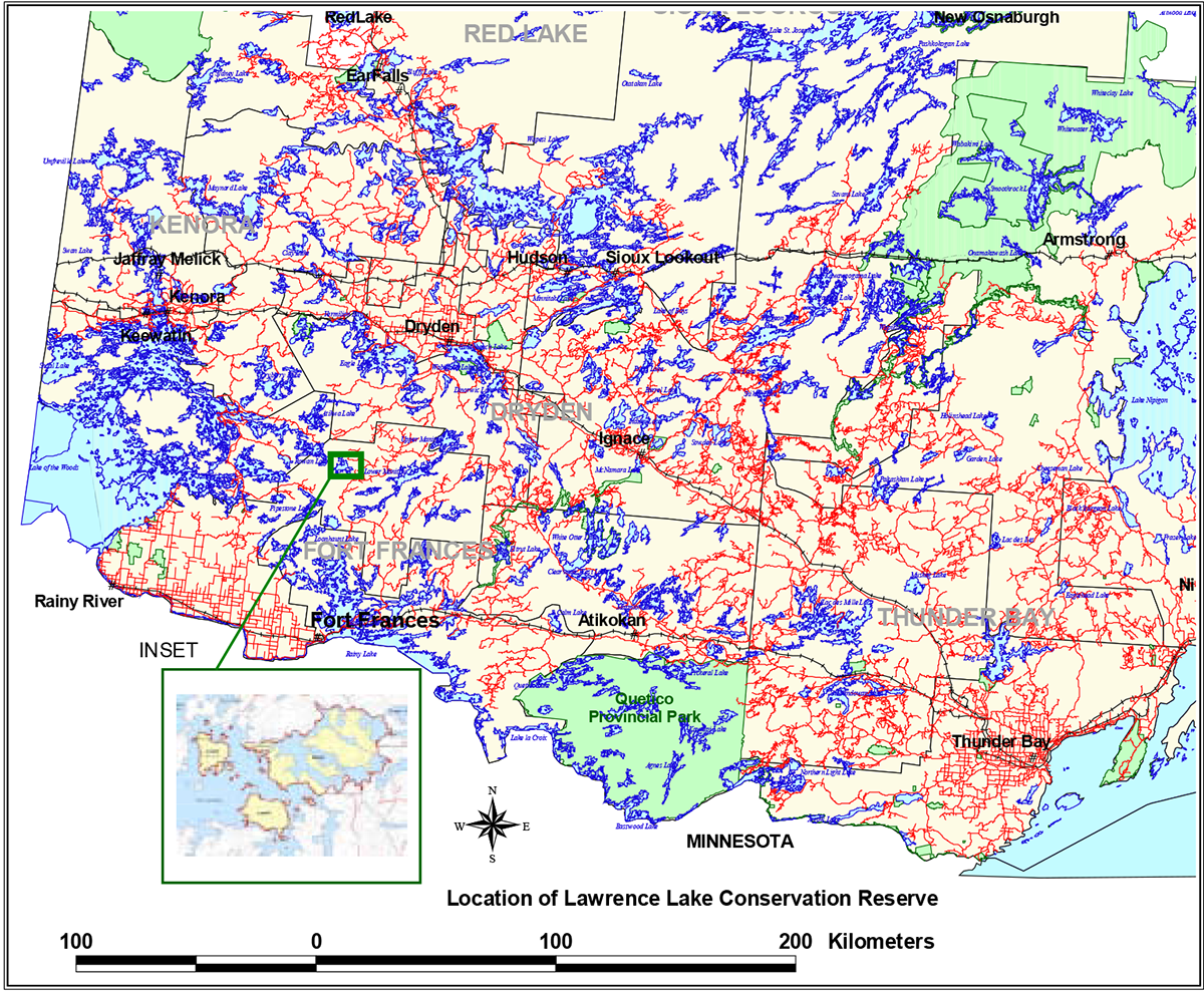
Figure 1: Location of Lawrence Lake Conservation Reserve

Enlarge Figure 1: Location of Lawrence Lake Conservation Reserve
1.0 Introduction
On July 16, 1999, the Ontario Government released the Ontario’s Living Legacy Land Use Strategy to guide the planning and management of Crown lands in central and parts of northern Ontario. A major part of the Ontario’s Living Legacy Land Use Strategy was a government intent to establish 378 new protected areas. This commitment marks the biggest expansion of provincial parks and conservation reserves in Ontario’s history.
The Lawrence Lake Conservation Reserve is part of this significant expansion of Ontario’s protected areas system.
Conservation reserves are areas of Crown land set aside by regulation under the Public Lands Act, complementing provincial parks in protecting representative natural areas and special landscapes. Most recreational (e.g. hiking, skiing, tourism related uses, nature appreciation) and non-industrial (e.g. fur harvesting, commercial fishing and bait harvesting) activities that have traditionally been enjoyed in the area will continue, provided that these uses do not impact on the natural features needing protection. Hunting and fishing is permitted within all new conservation reserves proposed through Ontario’s Living Legacy.
Commercial timber harvesting, mining, aggregate extraction and commercial hydroelectric development are prohibited in conservation reserves.
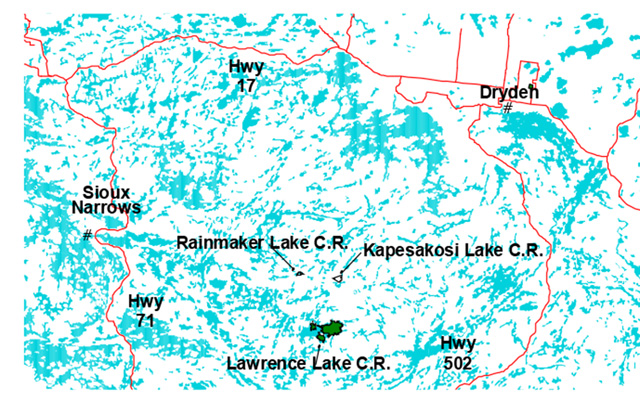
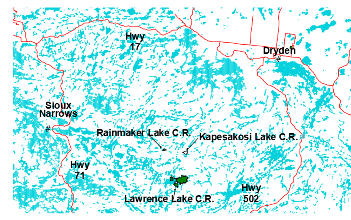
Lawrence Lake Conservation Reserve is located in northwestern Ontario in the Fort Frances Administrative District of the Ontario Ministry of Natural Resources, approximately 75 kilometres north of the town of Fort Frances. The conservation reserve and surrounding area is largely undeveloped Crown land and the dominant land uses are resource-based tourism, recreation and forestry. Forest access roads surround the Reserve, but access controls are in place in those instances where all-weather roads approach closely, preserving the remoteness of the area. Access may be gained by floatplane or, with some effort, by water and portage.
Lawrence Lake Conservation Reserve is located within Hills' Site Region 4S and Site District 4S-5 (Hills, 1961). The area occupies an upland of moderately to steeply rolling and broken bedrock terrain situated on the felsic intrusive rocks of the Lawrence Lake Batholith, adjacent to the mafic metavolcanic rocks of the Rowan Lake greenstone belt. Surficial geological features are dominantly ground moraine, representing shallow tills forming a discontinuous cover over the Precambrian bedrock. Rock outcrops are frequent, including a dramatic fault scarp at Gibraltar Narrows. Mineral potential is rated as low (least) (Springer, 1978). The rugged topography varies from a maximum elevation of approximately 400 metres on the hilltops to approximately 350 metres along the shorelines. Evidence of carbonate content in the soil is manifested in the common occurrence of eastern white cedar throughout the area, perhaps originating in the greenstone belts surrounding the batholith and deposited by ice advancing from the northeast across the area from the Labradorean centre during the last glacial period. Organic deposits occur in the depressions between the surrounding uplands and on the margins of watercourses.
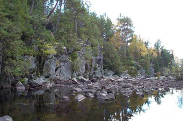
Figure 2: Rock scarp on the south side of Gibraltar Narrows, between Lawrence and "Back Lawrence" Lakes.
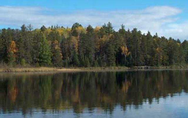
The upland forests and wetlands captured by the Lawrence Lake Conservation Reserve include representative areas of red and white pine, jack pine, spruce-pine conifer, fir-spruce mixedwoods, hardwood mixedwoods, black spruce treed bog, eastern white cedar, black spruce swamp, thicket swamp, shore fen, open fen and exposed marsh. The occurrence of abundant red and white pine here which are more common further to the south led to the inclusion of the area as part of the Great Lakes - St. Lawrence Forest Region (Rowe, 1972). Lying on the northern edge of this forest region, near the boundary with the northern Boreal Forest Region, the forests tend to have a more boreal character in terms of dominant species. Rowe recognizes the Rainy River area as part of a separate section of the forest region that is influenced by the northward movement of the southern forest, the prairie to the west and the northern forest.
The conservation reserve does not contain any known rare species, however detailed life science surveys would be required to confirm this. Species diversity within this conservation reserve is not expected to be as great as that for areas lying farther to the south in the District. The northern character of the forests of the conservation reserve provides habitat for boreal species such as moose, lynx, red squirrel, black bear, marten and great grey owl. Bald eagles frequent the area and one nesting site has been identified within the conservation reserve. Further nesting sites have been identified on surrounding lakes for both bald eagle and osprey. The bays of the lakes and connecting waterways provide abundant nesting and foraging habitat for waterfowl, although the area lies outside of major flyways. Lawrence Lake is a deep, coldwater lake that contains lake trout and lake whitefish, as well as northern pike and walleye. Spawning areas have been identified at Gibraltar Narrows, on the Penassi River at both the outlet and inlet of NE Lake and the outlet of SE Lake.
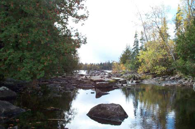
The site has a high potential for outdoor recreational activities, particularly those associated with remote camping canoeing, hunting and fishing. No direct road access exists to the area, with seasonal access controls in place where all weather roads approach closely. Access may be gained via Frypan Lake and the Penassi River from the east, off the Cedar Narrows and Penassi Roads, but two difficult portages are required and trails are not maintained. Access may also be gained via canoe routes connecting to Rowan and Atikwa Lakes to the west, and Pipestone Lake Conservation Reserve through Upper Lawrence and Ashiegamo Lakes to the south. Several sand beaches suitable for swimming do exist on the lakes of the conservation reserve, but most of the shoreline is rocky or bouldery. Numerous sites suitable for camping exist.
Figure 3: Frypan Portage looking west into NE Lake.
The purpose of this Statement of Conservation Interest is to identify the natural heritage values of the Lawrence Lake Conservation Reserve, the activities which occur there and, through a set of management guidelines, outline the activities which will and will not be permitted, as well as the management direction for the area (MNR, 1997).
2.0 Background Information
The Lawrence Lake Conservation Reserve is an area protected as representative of red and white pine and mixed forests on bedrock-dominated terrain. The area is not accessible by road, and measures have been implemented to preserve the remoteness of the site. Remote, resource-based tourism and wilderness recreation ore the two dominant land uses within the conservation reserve, and comparatively little development has occurred. Lawrence Lake is a waypoint on a significant canoe route leading from Rainy Lake to the south to Lake of the Woods to the west. It forms part of a system of protected areas in this part of the Province created under Ontario’s Living Legacy which include the larger Pipestone Conservation Reserve which lies approximately 9 kilometres to the south and the Eagle - Dogtooth Provincial waterway Park to the northwest.
Table 1. Background Information
| Name | Lawrence Lake Conservation Reserve |
|---|---|
| Site region / Site district | 4S/4S-5 |
| Ecosite class | ES 12, 13, 14, 15, 17, 18, 19, 20, 21, 23, 26, 32, 34, 35, 41, 44, 45 and 48 |
| OMNR administrative region / district / area | Northwest / Fort Frances / Rainy River-Manitou Area |
| Total Area (ha) | 1,416 |
| Regulation date | Not yet regulated. |
| First Nations with Interest in Area | Treaty Three: Whitefish Bay and Sabaskong Bay (Ojibways of Onegaming) First Nations. Other First Nations may also have an interest. |
| OBM | 15U 4750/54550 |
| Lat./Long. | 49°15'00"N; 93°20'00"W |
| Basemap | 2015 470054500, 470054600, 480054500 & 480054600 |
| Forest cover | Mixed forest: red pine, white pine, jack pine, black spruce, cedar, poplar and white birch. Predominantly upland, but also contains examples of treed lowlands. (Refer to Appendix D) |
| General location
Description |
The Lawrence Lake Conservation Reserve is situated approximately 75 kilometres north of the Town of Fort Frances, 9 kilometres north of the Pipestone Lake Conservation Reserve. The conservation reserve is comprised entirely of Crown land within unorganized territory (refer to Figure 1.) |
| Access | Access can be gained via floatplane, through the canoe routes/waterways from the northwest or south, or via portaging through Frypan Lake from the Cedar Narrows and Penassi Roads from the east. Access is restricted seasonally on the Hector Road to the north of the conservation reserve, and the site is not accessible by road. |
2.1 Targets
This section provides a summary of the earth and life science system and values, cultural resources represented and recreational opportunities available or possible.
Table 2. Summary of Social, Economic and Environmental Opportunities
| Life science representation | The Lawrence Lake Conservation Reserve contains representative examples of burn, conifer forest, conifer mixed forest, deciduous forest, open wetland, and sparse forest over ground moraine within Site District 4S-5.
The most distinctive life science features of the conservation reserve are the mixed white and red pine stands and ecosites that occur throughout. The abundance of eastern white cedar is also significant in terms of representation within this site district. All three species occur here near the northern limits of their ranges. Although no rare species have been identified or confirmed within the conservation reserve, the variety of habitat, both upland and aquatic is quite diverse within the site. The lakes and rivers associated with the reserve include both deep, cold waters supporting lake trout, and shallow waters that support warm water species. Four identified fish spawning sites have been identified within the reserve, below rapids in the connecting waterways. Common sportfish present include lake whitefish, lake trout, walleye and northern pike. A variety of wetland habitats are also represented within the site, including shallow water marshes that provide nesting and foraging habitat for waterfowl and wading shorebirds and other wildlife. Upland forests include hardwood and conifer, as well as mixedwood habitat. Moose, beaver, black bear and other boreal species are common throughout the area, and 11 moose aquatic feeding areas have been identified within or adjacent to the conservation reserve. One known bald eagle nesting site has been identified within the conservation reserve, but this species is common throughout the area and potential nesting sites along the large amount of shoreline within the reserve, represented by large white pine, are numerous. Detailed life science surveys have not been conducted on the site. No records of rare species occurring in the area exist (NHIC, 2001). |
|---|---|
| Earth science representation | The dominant landform feature is moderately broken bedrock knob with subordinate ground moraine and organic terrain (Roed, 1980). A thin, discontinuous, sandy glacial till has been deposited over the felsic intrusive granitoid bedrock, with minor glaciolacustrine silts and clays. (Blackburn, 1981, Barnett et al., 1991). Stones and boulders of glacial origin alternate with bedrock to form much of the shoreline of the lakes within the conservation reserve. Sand beaches are less common. |
| Cultural resource representation | The site contains no known cultural resource values. Although located along a travel route believed to have been used by native peoples historically, the frequency of much larger waterbodies to the north, west and south may have limited the use of the Lawrence Lake area to incidental use. More recent uses have been associated with recreation. |
| Recreational opportunities | The overall recreational potential of the conservation reserve is ranked as high to very high. Of the potential recreational activities identified, those which are associated with backcountry camping and canoeing, hunting and fishing are considered the most viable, although these are somewhat hampered by access limitations and difficulty. Such activities could also include nature study, bird and wildlife viewing and photography.
The limited easy access to the area tends to limit use primarily to the few camp owners on Lawrence Lake and guests of the tourist lodge located there. As a consequence both game and fish populations are relatively high. Opportunities for hunting and fishing are therefore considered excellent for those wishing to make the effort. The conservation reserve lies on a significant canoe route leading from Rainy Lake through Footprint, Burditt, Pipestone, Yoke, Crossroute, Ashiegamo and Upper Lawrence Lakes to the south, to Lake of the Woods through Hill, Rowan, Denmark, Caviar and Dogpaw Lakes to the northwest. It is also possible to follow connecting lakes and rivers through to the Eagle-Dogtooth Provincial Waterway Park to the northwest. Several established campsites have been identified on Lawrence, Back Lawrence and NE Lakes (Refer to Map 3) and numerous other suitable locations exist throughout the site. A limited number of sand bathing beaches exist, with the largest and best examples being on the north shore of Back Lawrence Lake. |
2.2 Survey information
This section provides an overview of the inventories completed, their level of detail and any further inventories required.
Table 3. Level of survey performed
| Survey Level | Life Science | Earth Science | Cultural | Recreational |
|---|---|---|---|---|
| Reconnaissance | Yes 1 | Yes 2 | No | Yes 3 |
| Detailed | No | No | No | No |
| Requirement | No | No | No | No |
1Foster and Harris, 2002
2Blackburn, 2002
3Munroe, 2002
The reconnaissance surveys which have been completed, in conjunction with other values and earth/life science records for the area (OMNR, 2002) are deemed sufficient in scope and detail to determine management direction for the conservation reserve. More detailed surveys may be undertaken at a later time if circumstances change.
3.0 Values to be protected
This section provides a description of the key natural heritage values on the site (Appendices) and their condition relative to past resource use and management activities. It also addresses the values' sensitivity to future land use and management activities.
3.1 Values identified in the conservation reserve
Life science
Identified ecosites classified in accordance with the Northwestern Ontario Forest Ecosystem Classification (Racey et al., 1996) within the conservation reserve include:
- ES12 Black Spruce - Jack Pine: Very Shallow Soil
- ES13 Jack Pine - Conifer: Dry - Moderately Fresh, Sandy Soil
- ES14 Pine - Spruce Mixedwood: Sandy Soil
- ES15 Red Pine - White Pine: Sandy Soil
- ES17 White Cedar: Fresh - Moist, Coarse – Fine Loamy Soil
- ES18 Red Pine - White Pine: Fresh, Coarse Loamy Soil
- ES19 Hardwood-Fir-Spruce Mixedwood: Fresh, Sandy – Coarse Loamy Soil
- ES 20 Spruce-Pine / Feathermoss: Fresh, Sandy – Coarse Loamy Soil
- ES21 Fir - Spruce Mixedwood: Fresh, Coarse Loamy Soil
- ES23 Hardwood-Fir-Spruce Mixedwood: Moist, Sandy – Coarse Loamy Soil
- ES26 Spruce-Pine / Feathermoss: Fresh, Fine Loamy – Clayey Soil
- ES32 Fir - Spruce Mixedwood: Moist, Silty – Clayey Soil
- ES34 Treed Bog: Black Spruce / Sphagnum: Organic Soil
- ES35 Poor Swamp: Black Spruce: Organic Soil
- ES41 Open Poor Fen: Ericaceous Shrub – Sedge/Sphagnum: Organic Soil
- ES44 Thicket Swamp: Organic-Mineral Soil
- ES45 Shore Fen: Organic Soil
- ES48 Exposed Marsh: Emergent: Mineral Substrate
A map displaying the distribution of the represented ecosites is contained in Appendix C.
Those parts of the conservation reserve supporting tree growth include areas dominated by red pine, white pine, jack pine, black spruce, eastern white cedar, white birch and aspen. The presence of carbonates in the glacial tills may explain the occurrence of cedar throughout the site, both as a dominant and component species. The age of the forest cover ranges from 54 to 155 years, and averages 83 years of age. The eastern white cedar and lowland black spruce represent the oldest stands, while white birch represents the youngest. The red and white pine in the area are relatively young, with most being less than 100 years of age, although older individuals may exist. Some natural disturbance of the forest has occurred in the easternmost portion of the conservation reserve. A small area of recent burn has been identified, and older areas of disturbance occur sporadically throughout the area. The lack of jack pine regeneration and the existence of balsam fir would suggest that the area was damaged by wind. Appendix C contains a forest cover map and Appendix D contains stand listings for the conservation reserve.
Lawrence and Back Lawrence are deep, coldwater lakes which contain lake trout, lake whitefish, walleye and northern pike.
The vegetation of the conservation reserve is typical of the ecosites represented, with no rare plants having been documented for this site. Although a detailed survey of plant species has not been undertaken, a list of the plant species identified during reconnaissance surveys on the site is contained in Appendix B.
Earth science
The bedrock geology has not been intensively studied in this area, and more detailed investigation of the entire Lawrence Lake batholith would be required in order to present a comprehensive picture for the Lawrence Lake Conservation Reserve.
Located within the western portion of the Wabigoon subprovince, the Lawrence Lake Conservation Reserve lies entirely atop the felsic igneous rocks of the Archean age Lawrence Lake Batholith. Reconnaissance surveys found rocks consisting of granites and granodiorite cut by narrow dikes of pegmatite and felsic porphyritic rocks ( Blackburn, 2002). The topography is moderately broken, with bedrock knob terrain predominating, rising from an elevation of approximately 350 metres along the shoreline to 400 metres on some of the island and peninsular hilltops. The area is covered by a thin, discontinuous drift of sandy glacial till, with minor occurrences of fine-textured glaciolacustrine sediments and Recent organic deposits occupying depressions between the bedrock knolls. Deeper surficial deposits are localized and tend to occur on the down-ice side of the ice movement to the southwest, in the lea of bedrock features.
Much of the shoreline within the conservation reserve consists of exposed bedrock that ranges from relatively flat to steep, near-vertical cliff faces. Elsewhere large glacially deposited boulders line the shore and form boulder-choked channels in the rapids along connecting streams. Exposed sand beaches are less common, but do exist on the north shore of Back Lawrence Lake and on Emm Island. Submerged beaches, often accompanied by aquatic vegetation also occur sporadically.
A minor fault line is apparent extending northeast-southwest along the northern end of Back Lawrence Lake. A dramatic fault scarp associated with this feature, approximately 4 metres in height (Figure 2), lies along the rapids between Lawrence and Back Lawrence Lakes at Gibraltar Narrows. Another example exists along the northern end of the peninsula on the east side of Back Lawrence Lake.
A large boulder shoal lies just beneath the surface of the water in the middle of the southeastern channel of Lawrence Lake. This feature may only be exposed during low water conditions.
The abundance of eastern white cedar, that cedar tends to favour more alkaline soils, would seem to indicate the presence of carbonate material within the glacial tills despite the fact that the area is underlain by granitoid rocks which are associated with acidic soil conditions. The source of the carbonates may be the metamorphic rocks of the greenstone belt that surrounds the Lawrence Lake Batholith.
Cultural
The area contains no identified cultural heritage values.
Aboriginal
The area contains no identified aboriginal values.
Tourism
Lawrence Lake Conservation Reserve is located in an area rated high for remote, resource-based tourism values. Although forest access roads surround the site, seasonal access controls are in place (Hector Road) to preserve the remoteness of the area.
Opportunities exist for hunting and fishing based on the fish and wildlife resources of the area, which include lake trout, lake whitefish, northern pike, walleye, black bear, moose, upland gamebirds and waterfowl. The access limitations limit hunting and fishing pressure on the resources that tends to preserve the local populations compared to surrounding, more accessible areas.
Although not heavily used for this purpose presently, the area does represent opportunities for non-consumptive tourism. Canoe routes, both formal and informal connect the conservation reserve with the Pipestone Conservation Reserve to the south, Eagle - Dogtooth Provincial Waterway Park to the northwest, and Lake of the Woods to the west. Associated activities such as wildlife viewing and wilderness camping may also have commercial value.
One commercial tourist lodge is located on private land adjacent to the conservation reserve on the north shore of Lawrence Lake, to the west of Gibraltar Narrows. Commercial boat caches are located at Gibraltar Narrows, at a narrows to the south between Lawrence and Back Lawrence Lakes, along the portage from Back Lawrence Lake into SE Lake and on the Penassi River where it empties into NE Lake from Frypan Lake.
Recreational fishing
The conservation reserve encompasses four lakes which support gamefish populations: Lawrence, Back Lawrence, NE and SE Lakes. Species present include lake trout, walleye, lake whitefish and northern pike. The quality of the fishery is considered high, maintained by the access limitations in place. For canoeists passing through or those willing to make the effort required to gain access, the rewards are potentially higher than would be expected for more readily accessible waters.
Recreational/ commercial hunting
Hunting potential, particularly for moose and bear is considered to be high, although access is a limitation. Seasonal road use restrictions on the Hector Road to the north are lifted after September, as these restrictions are aimed primarily at preserving the quality of the fisheries. However, the Hector Road is currently unmaintained and a beaver dam on the road presently blocks access by this route. Hunting for upland gamebirds and waterfowl also present opportunities, although in the latter case the area is off major flyways and may be limited primarily to early-season hunting of locally nesting birds. The area contains portions of two Bear Management Areas (BMA's), FF 08-55 and 09A-29. (Refer to Map 3)
Mining
The conservation reserve and surrounding area contain no active mining claims, with exploration in the area tending to focus on the area of the greenstone belt to the west, where active claims do exist. The area is ranked as low (least) in terms of mineral potential (Springer, 1978).
Aggregate
The area is generally low potential for aggregate extraction, with deposits tending to be shallow tills over bedrock. (Roed, 1980) No aggregate pits currently exist in proximity to the conservation reserve.
Forest harvest
Apart from some periodic logging of Crown lands surrounding the conservation reserve, no forest harvesting has been documented in this area. .
Trapping
The conservation reserve contains a portion of trapline FF21. A cabin associated with this trapline is located within the conservation reserve at Gibraltar Narrows.
Wild rice
Commercial wild rice harvesting currently does not occur within this conservation reserve, nor have stands been identified.
Wildlife
Although a detailed life science survey would be required to document and substantiate all of the flora and fauna occurring within the conservation reserve, the variety of upland, wetland and aquatic habitat would suggest that the area supports a wide variety of the commonly-occurring local species, either as resident or nesting populations, or occasional visitors. Wildlife species observed in the area during reconnaissance surveys include moose, black bear, beaver, river otter, red squirrel, least chipmunk, bald eagle, broad-winged hawk, common loon, herring gull, turkey vulture, wood duck and pileated woodpecker. One bald eagle nesting site has been identified within the conservation reserve. A list of the commonly occurring vertebrate species that may be found in the area is contained in Appendix B.
Commercial Fish
No commercial fishing for human consumption exists within the conservation reserve. Commercial baitfishing does occur, with the area forming parts of baitfish blocks FF-132 and FF-137, and will be permitted to continue.
3.2 Values protection
The intent of this Statement of Conservation Interest is to protect the identified values by establishing management guidelines for existing and potential uses in this area, given the level of past disturbance and the nature of the existing features. Uses and activities which are permitted, not permitted or conditionally permitted are governed by the policies applying to conservation reserves as stated in the Land Use Strategy and existing conservation reserve policy. Any new uses, and commercial activities associated with them, will be considered on a case by case basis, and must pass a test of compatibility to be acceptable. Compatibility is normally determined through a planning process. The policies outlined in this Statement of Conservation Interest do not supersede any Aboriginal or treaty rights that may exist, or other legal obligations.
Forest values
The upland forest types and ecosites identified will continue undergoing natural successional changes already initiated, towards a spruce-fir forest without the advent of a major disturbance such as. fire. The eastern white cedar forest ecosites are not expected to change, given the autecology of the primary species. The treed and untreed peatland features are also likely to remain unchanged in the absence of natural disturbances such as fire. Human activities that represent the greatest potential impacts on forest structure, such as logging, mining and hydroelectric development, will not be permitted. However, sustaining these values in the long-term may require development of a vegetation management plan and natural disturbance strategy.
Activities occurring on adjacent lands surrounding the conservation reserve are not expected to have a significant impact on the ecology of the site, with the actual interface between the forested portions of the site and adjacent lands being relatively limited, confined six relatively small areas (Refer to Map 1). Where the waters within the conservation reserve abut unregulated Crown lands, normal no-cut reserves buffer surrounding forest harvesting activities.
Recreational and commercial values
The Lawrence Lake Conservation Reserve contains features that may hold interest for amateur and professional naturalists. There is the potential for a number of low impact, non-consumptive recreational activities such as canoeing, camping, wildlife viewing and photography, although access difficulties are expected to continue to limit use.
The existing traplines, baitfish harvest areas and bear management areas within the conservation reserve will remain and existing uses associated with them allowed to continue. New operations may be considered, subject to the "test of compatibility". Normal application of controls such as quotas and seasons are designed to ensure that affected wildlife populations remain sustainable. Use of existing trails will be allowed to continue. Proposals for the development of new trails to permit access for these activities will be considered carefully to ensure that the values of the conservation reserve are protected. Recreational hunting and fishing will be permitted, although it is expected that access limitations will limit these activities and the level of use may remain relatively low.
Traditional recreational hunting and fishing will continue to be a significant activity, although access limitations and difficulties will continue to limit numbers of users, which in turn will help to maintain the quality of the resources.
Tourism values
Access to this area is limited by a lack of all-weather access roads to or within the site, and the application of seasonal use controls on those roads that approach the area, such as the Hector Road. A tourist lodge currently exists on Lawrence Lake west of Gibraltar Narrows, with boat commercial caches located at strategic portages throughout the conservation reserve. Portages within the Reserve tend to be maintained by the tourist operator for the use of their guests and local cottagers for personal use. Portages leading to and from the Reserve tend to be either unmaintained or non-existent, contributing to the remoteness of the area. The quality hunting and fishing represent the traditional tourism values for the area, but other non-consumptive activities associated with the earth and life science features are possible. The sinuous nature of the waterbodies, most connected by existing portages, represent undeveloped possibilities for a variety of wildlife viewing and nature appreciation activities associated with a reasonable day trip or short overnight canoe trip for novice canoeists, all within a remote wilderness setting.
4.0 Management guidelines
4.1 Land tenure
The Lawrence Lake Conservation Reserve consists entirely of Crown land and no disposition of Crown land by sale is permitted within the conservation reserve. The surrounding and adjacent lands consist largely of Crown lands, although four small private holdings occur adjacent to the conservation reserve, all on Lawrence Lake. No expropriation or purchasing of private land for inclusion in the conservation reserve is planned. New leases or land use permits may be considered for approved activities, subject to the "test of compatibility", but will generally be discouraged within the conservation reserve.
4.2 Existing and proposed development
No mining development or mineral exploration activities will be permitted within the conservation reserve.
No roads currently exist within the area and no new roads will be permitted.
No commercial aggregate permits exist for the area of the conservation reserve and no new permits will be issued. Aggregate extraction will not be permitted.
No logging operations or facilities, nor hydro-electric facilities or structures exist within the area and no new development will be permitted.
No cabins or other facilities associated with commercial bear management or baitfish harvesting on the site exist, and no new facilities will be permitted. One trapper’s cabin currently exists within the Reserve and may remain in accordance with existing policy, but no new cabins associated with this activity will be permitted. Existing trails used in conjunction with these activities may continue to be used, but new trails will only be considered subject to the "test of compatibility". New fur harvesting or commercial baitfishing operations can also be considered, subject to the "test of compatibility".
No trails suitable for recreational purposes, such as hiking, skiing, snowmobiling or horseback riding, exist within the conservation reserve. The development of new trails will be subject to further planning if considered desirable. Under such circumstances planning will favour the upland portions of the site, and avoid the wetland features and other sensitive areas in locating trails.
No private recreational camps currently exist within the conservation reserve and no new camps will be permitted. (Note: three private recreation camps exist on private lands not included within the conservation reserve, on Emm Island and west of Gibraltar Narrows,)
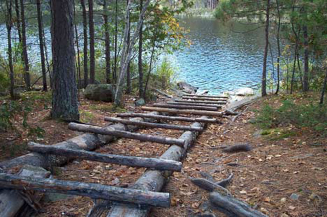
Portages exist between Lawrence and Back Lawrence Lakes at Gibraltar Narrows and a small narrows to the south. Local users have constructed a rudimentary log structure for portaging laden boats across the Gibraltar portage. Additional short portages exist on the Penassi River between Back Lawrence and NE Lake, and between Back Lawrence and SE Lake. Any proposals to improve existing portages or create new ones will be subject to the "test of compatibility".
Figure 4: Log portage structure on portage at Gibraltar Narrows.
4.3 Recreational activities
Recreational hunting will be allowed to continue within the conservation reserve, subject to applicable regulations. The use of motorized and non-motorized means of transport will be permitted, but ATV's will be limited to existing trails. New trails may be permitted, subject to the "test of compatibility", and will be discouraged within the wetland features and other sensitive areas of the site. Other recreational low impact activities and non-motorized recreational travel such as skiing, canoeing and hiking are permitted.
The use of mechanized means of transport such as snowmachines and all-terrain vehicles off of existing trails will not be permitted, except for direct retrieval of game in accordance with existing conservation reserve policy. Evidence of existing snowmachine use is limited to the waters of Lawrence Lake (Refer to Map 2).
Existing Ministry policies and regulations relating to Crown land camping will apply. Existing policies relative to boat and equipment caches will also apply.
Sport fishing is a permitted use within the conservation reserve, subject to applicable regulations.
Low-impact recreational activities such as nature appreciation, photography and wildlife viewing are permitted and will be encouraged.
4.4 Commercial activities
Activities associated with current traplines and baitfish harvesting areas in the conservation reserve will be permitted to continue in accordance with existing policies and regulations. New operations may be considered, subject to a test of compatibility.
Existing bear management areas will be permitted to continue in accordance with existing policies and regulations. No new operations are permitted.
No commercial tourism facilities, such as outpost cabins, resorts or lodges, exist within the conservation reserve, although one tourist lodge, located on private land outside the boundaries of the reserve, does exist on Lawrence Lake west of Gibraltar Narrows. New commercial tourism facilities within the Lawrence Lake Conservation Reserve may be considered, unless there are significant demonstrated conflicts, subject to review through the planning process as set out in the Draft Class Environmental Assessment for Ontario’s Provincial Parks and Conservation Reserves. Existing Ministry policies and regulations relating to Crown land camping will apply. Four commercial boat caches associated with commercial tourism operations exist within or adjacent to the conservation reserve. Existing policies relative to boat and equipment caches will apply.
No commercial food fisheries operations exist within the conservation reserve. New operations may be considered subject to the "test of compatibility".
Commercial wild rice harvesting does not occur within the conservation reserve, nor have any significant occurrences of wild rice been identified. No other commercial food harvesting (i.e., blueberries) activities have been identified. Any new activities will require the written authorization of the District Manager, be subject to a test of compatibility and alternative locations will be preferred.
4.5 Aboriginal interests
The creation of this conservation reserve will not affect any Aboriginal or treaty rights. Consultation with interested First Nations towards identifying cultural and spiritual values within the area will continue.
4.6 Natural resources stewardship
4.6.1 Vegetation management
The Lawrence Lake Conservation Reserve will be managed to allow natural processes to continue. Suppression of fire will occur in accordance with existing MNR fire suppression strategies. Prescribed burning may be carried out to simulate natural fire, subject to a planning process. The development of a vegetation management plan for the area in the context of regional fire strategies is recommended over time.
Control of insects and diseases within the conservation reserve will be carried out, if required, in accordance with existing Provincial programs and policies. All such proposed activities will be reviewed carefully to ensure that the values of the conservation reserve are protected. Control of non-native species will be considered a priority.
The use of pesticides and other control agents within the conservation reserve, should such measures be considered desirable, will favour biological controls.
4.6.2 Fish and wildlife management
Current Acts, Regulations and Policies will apply. The lands and waters of the conservation reserve will be included in scheduled fish and wildlife management programs and activities. The terrestrial and wetland ecosites of the conservation reserve will be considered in other resource management planning as a component of the wildlife habitat in the broader landscape. The introduction of non-native species will not be permitted.
4.6.3 Landforms
Activities that tend to impact landforms, such as aggregate extraction and road construction, will not be permitted.
4.7 Non-commercial consumptive uses
The consumptive uses of fish and wildlife resources within the conservation reserve are discussed under Section 4.3, and commercial consumptive uses under Section 4.4.
Non-commercial food gathering activities such as berry picking for personal use will be permitted to continue. Plant collection except for approved research or inventory purposes will not be permitted.
Non-commercial harvesting of traditional forest products such as fuelwood for personal use will may be permitted within the conservation reserve, subject to existing Provincial legislation and policy, only if other viable alternatives do not exist outside the Reserve boundaries. The location of any areas where such activities may be permitted will be determined subject to the test of compatibility.
4.8 Cultural resources stewardship
The location and specific details regarding cultural heritage resources may be kept confidential in order to ensure protection of such values and sites. No cultural heritage values have been identified within the site to date.
4.9 Client services
No on-site facilities or services exist within the conservation reserve, nor are any proposed at this time.
The permitted uses and recognized values of this conservation area will be made known to the public through public consultation associated with the Land Use Strategy, the site regulation process, and materials, including this Statement of Conservation Interest, available through Government Information Centres. No significant advertising campaigns for the Lawrence Lake Conservation Reserve are planned at this time.
Future planning for the conservation reserve will be in accordance with the Class Environmental Assessment for Provincial Parks and Conservation Reserves, which may involve formal public consultation.
4.10 Research
Research activities which do not detrimentally affect the values which the conservation reserve is designed to protect will be encouraged, but will require the written authority of the District Manager.
4.11 Marketing
No marketing associated specifically with this conservation reserve for tourism and recreational purposes is planned at this time.
5.0 Implementation
The Lawrence Lake site will be regulated as a conservation reserve under the Public Lands Act, in 2002, following the process set out in the Ontario’s Living Legacy Protected Areas Regulation Implementation Manual (MNR, 2000).
The Fort Frances District, Rainy River/Manitou Area of the Ministry of Natural Resources will be responsible for implementing the management policies and guidelines for the area. All MNR Resource Management Plans or Land Use Plans have been revised as necessary to exclude timber harvesting and other non-permitted activities from this area. All stakeholders and clients will be informed through mail and other consultation of the changes that will take affect. The Rainy River/Manitou Area will have primary responsibility in administering the policies and guidelines. The primary role is providing public information and monitoring of compliance to the policies and guidelines.
6.0 Review and revisions
6.1 Review and revision process
The Lawrence Lake Conservation Reserve Statement of Conservation Interest will be reviewed on an ongoing basis and revised as needed.
Revisions to the Lawrence Lake Statement of Conservation Interest will be subject to the requirements as specified in the Draft Class Environmental Assessment for Provincial Parks and Conservation Reserves. Significant changes as defined under the Class EA will involve a public consultation process and approval from the District Manager and Regional Director of the Ministry of Natural Resources.
6.2 Public consultation
6.2.1 Past consultation
The Lawrence Lake site was part of the consultation process in the land use planning exercise. Consultation associated with the land use planning initiative occurred at a number of stages in the process:
- Lands For Life round table consultation June 1997- July 1998
- Ontario Forest Accord 1999
- Ontario’s Living Legacy round table discussions 1999
- Ontario’s Living Legacy Land Use Strategy 1999
- OLL Site Regulation Public Consultation Process 2001
6.2.2 Present and future consultation
Summary of the 2001 Site Regulation Process:
- Mailouts were sent to adjacent property owners and other affected and interested parties and agencies by the District Manager, and newspaper ads placed in local and regional media, informing of the regulation process and inviting comments on the proposed boundaries
- A concern was raised by a local property owner who indicated that his lot on Emm Island was shown in the wrong location and provided a corrected map. Secondly, he proposed an expansion of the protected area to include a sizeable area on the south of Lawrence Lake between that lake and Upper Lawrence Lake, citing concerns over water crossings, an Eagle nest and mature timber in the location as rationalization
- Recommendations: Based on the input received, revisions to the boundaries of the site in the location of the private lot on Emm Island were deemed necessary. No expansion of the protected area based upon the values represented was recommended
(More detailed Consultation Documentation is available on file at the Fort Frances District offices of the Ministry of Natural Resources)
The policies that form the basis of this Statement of Conservation Interest are specified in the approved Ontario’s Living Legacy Land Use Strategy. A policy statement defining the land use intent and specific policies applicable to this conservation reserve may also be found posted on the internet as part of the Land Use Atlas (under preparation, expected completion 2002). Should revisions to the policies applying to this conservation reserve be required over time, such revisions will be subject to the provisions of the Land Use Strategy regarding amendments.
7.0 References
Barnett, P.J., Henry, A.P. and Babuin, D. (1991): Quaternary geology of Ontario, west central sheet. Ontario Geological Survey. Map 2554. scale 1:1,000,000.
Blackburn, C. 2002. Earth Science Reconnaissance: C2409 Lawrence Lake C.R.. OMNR unpublished report. 16 p.
Blackburn, C. E. 1981. Kenora-Fort Frances sheet. Ontario Geological Survey. Geological compilation series. Map 2443. scale 1:253,440.
Foster, R. and Harris, A. 2002. Life Science Reconnaissance: C2409 Lawrence Lake C.R. Northern Bioscience. OMNR unpublished report. 16 p.
Hills, G.A. 1961. The Ecological Basis for Land-Use Planning. Ont. Dept. Lands and Forests. Toronto, Ont. Res. Rep. No. 42. 63 pp.
Ministry of Natural Resources (MNR). 1997. Conservation Reserves Policy and Procedure. PL 3.03.05.
Ministry of Natural Resources (MNR). 2000. Protected Areas Regulation Implementation Manual; Internal Document.
Munroe, J. 2002. Recreation Inventory Report – Lawrence Lake Conservation Reserve Ministry of Natural Resources, Fort Frances District.
NHIC 2001. Natural Heritage Information Centre Database. Ontario Ministry of Natural Resources. Page.< http://mnrweb.mnr.gov.on.ca/nhic/nhic.cfm >. Accessed 2001, Aug. 23.
Ontario Ministry of Natural Resources (OMNR) 1996. Forest Resources Inventory – Highrock Forest. Ontario Ministry of Natural Resources Digital G.I.S. database, updated to year 2000.
Ontario Ministry of Natural Resources (OMNR) 1999. Ontario’s Living Legacy - Land Use Strategy. Ontario Ministry of Natural Resources Toronto, Ont. 136 pp.
Ontario Ministry of Natural Resources (OMNR). 2002. Natural Resources Values Information System (NRVIS). Fort Frances District.
Racey, G.D., Harris, A.G., Jeglum, J.K., Foster, R.F. and Wickware, G.M. 1996. Terrestrial and Wetland Ecosites of Northwestern Ontario. Ont. Min. Natur. Resour., Northwest Sci. & Technol. Field Guide FG-02. 94 pp. + Append.
Roed, M.A. 1980. Rowan Lake Area (NTS 52F/SW). Districts of Kenora and Rainy River, Ontario. Geological Survey, Northern Ontario Engineering Geology Terrain Study 37. 13 p. Accompanied by Map 5060, scale 1:100,000.
Rowe, J.S. 1972. Forest Regions of Canada. Dept. Environ., Can. For. Serv. Ottawa, Ont. Publ. No. 1300 172 pp.
Springer, J. 1978. Ontario Mineral Potential, Dryden Sheet, Districts of Kenora and Rainy River. Ontario Geological Survey Prelim. Map P.1530, Mineral Deposits Ser., Scale 1:250,000
Appendix A: Permitted uses list
Land Use Activity for Lawrence Lake Conservation Reserve
Those uses and management activities not listed in the following table are governed by existing Conservation Reserve policy. Management direction is elaborated in the Statement of Conservation Interest. Any new uses, and commercial activities associated with them, will be considered on a case by case basis, and must pass a test of compatibility to be acceptable. Compatibility is normally determined through a planning process.
Commercial Activities
| Activity | Permitted | Guidelines |
|---|---|---|
| Aggregate extraction: | No | |
| Bait fishing - Existing | Yes | Existing use permitted to continue, unless there are significant demonstrated conflicts. |
| Bait fishing - New: | Maybe | New operations can be considered, subject to the "test of compatibility". |
| Commercial fishing - Existing: | Yes | Existing use permitted to continue, unless there are significant demonstrated conflicts. |
| Commercial fishing - New: | Maybe | New operations can be considered, subject to the "test of compatibility". |
| Commercial fur harvesting - Existing: | Yes | Existing use permitted to continue, unless there are significant demonstrated conflicts. Existing trap cabins can continue; new cabins are not permitted. |
| Commercial fur harvesting - New: | Maybe | New operations can be considered, subject to the "test of compatibility". |
| Commercial hydro development | No | |
| Commercial timber harvest | No | |
| Commercial tourism - Existing: | Yes | Existing authorized facilities can continue, unless there are significant demonstrated conflicts. |
| Commercial tourism - New: | Maybe | New tourism facilities can be considered during the planning for an individual reserve. |
| Bear hunting by nonresidents (guided) - Existing: | Yes | Existing authorized operations permitted to continue. |
| Bear hunting by nonresidents (guided) - New: | No | New operations not permitted. |
| Outfitting services - Existing: | Yes | Existing authorized facilities are permitted to continue. |
| Outfitting services - New: | Maybe | New operations can be considered during the planning for an individual reserve. |
| Outpost camps - Existing: | Yes | Existing authorized operations are permitted to continue. |
| Outpost camps - New: | Maybe | New facilities can be considered during the planning for an individual reserve. |
| Resorts/lodges - Existing: | Yes | Existing authorized facilities are permitted to continue. |
| Resorts/lodges - New: | Maybe | New facilities can be considered during the planning for an individual reserve. |
| Energy transmission and communications corridors - Existing: | Yes | These facilities should avoid conservation reserve lands wherever possible. |
| Energy transmission and communications corridors - New: | No | |
| Food harvesting (commercial) - Existing: | Maybe | Written authority required. |
| Food harvesting (commercial) - New: | Maybe | |
| Mineral exploration and development | No | |
| Peat extraction | No | |
| Wild rice harvesting - Existing: | Yes | |
| Wild rice harvesting - New: | Maybe |
Land and resource management activities
| Activity | Permitted | Guidelines |
|---|---|---|
| Crown land disposition - Private use: | Maybe | Sale of lands is not permitted, except for minor dispositions in support of existing uses (e.g., reconstruction of a septic system). Renewals of existing leases and land use permits are permitted. Requests for transfer of tenure will be considered in the context of the Statement of Conservation Interest or Resource Management Plan. New leases or land use permits permitted for approved activities. Tourism facilities can apply to upgrade tenure from LUP to lease. |
| Crown land disposition - commercial use | Maybe | |
| Fire suppression | Yes | Fire suppression policies are similar to adjacent Crown lands, unless alternative fire policies have been developed through a planning process. |
| Fish habitat management | Maybe | |
| Fish stocking | Maybe | Conservation Reserves policy indicates that "featured species management" may be permitted. |
| Insect/disease suppression | Maybe | |
| Inventory/monitoring | Yes | |
| Personal use permits for wood harvesting | Maybe | Existing permits may continue on an interim basis for properties that do not have road access. The long term status will be determined through management planning. |
| Prescribed burning | Maybe | May be carried out to simulate natural fire. Subject to a planning process. |
| Roads (resource access) - Existing: | Yes | Existing roads can continue to be used. Continued use will include maintenance and may include future upgrading. New roads for resource extraction will not be permitted, with the exception of necessary access to existing forest reserves for mineral exploration and development. |
| Roads (resource access) - New: | Maybe | |
| Vegetation management | Yes | Conservation Reserves policy indicates that Featured Species Management and Natural Systems Management may be permitted. Vegetation management can be considered in a planning process. |
| Wildlife population management | Maybe |
Science, education and heritage appreciation
| Activity | Permitted | Guidelines |
|---|---|---|
| Collecting | No | |
| Historical appreciation | Yes | |
| Nature appreciation | Yes | |
| Photography and painting | Yes | |
| Research | Yes | |
| Wildlife viewing | Yes |
Recreation activities and facilities
| Activity | Permitted | Guidelines |
|---|---|---|
| All-terrain vehicle use - On trails | Yes | Existing use permitted to continue where it does not adversely affect the values being protected. Off trails not permitted except for direct retrieval of game. |
| All-terrain vehicle use - Off trails | No | |
| Campgrounds | Maybe | |
| Food gathering | Yes | |
| Horseback riding (trail) | Yes | Existing use on trails permitted. |
| Hunting | Yes | |
| Mountain bike use | Yes | Existing use on trails permitted. |
| Motor boat use (commercial) | Yes | |
| Motor boat use (private) | Yes | |
| Non-motorized recreation travel | Yes | |
| Private recreation camps (hunt camps) - Existing | Yes | Existing camps permitted to continue, and may be eligible for enhanced tenure, but not purchase of land. |
| Private recreation camps (hunt camps) - New | No | |
| Rock climbing | Maybe | |
| Snowmobiling (On Trails) | Yes | Existing use permitted to continue where it does not adversely affect the values being protected. Off trails not permitted, except that snowmobiles maybe used for direct retrieval of game. |
| Snowmobiling (Off Trails) | Maybe | |
| Sport fishing: | Yes | |
| Trail development | Maybe | Development of trails for a variety of activities (e.g., hiking, cross-country skiing, cycling, horseback riding, snowmobiling) can be considered as part of planning for an individual reserve. |
Appendix B: Survey checksheets
Recreation inventory checklist
Lawrence Lake Conservation Reserve (C2409)
Lawrence Lake, NTS Number 52/F6, 52/F3 UTM reference 15
| OBM number | Latitude | Longitude | Area (ha) | Ownership |
|---|---|---|---|---|
| 470054500, 470054600, 480054500, 480054600 | 49 17' 00" | 93 18‘ 00" | 1,416.00 | Crown |
| MNR region | MNR district | Park zone | Count | Township |
|---|---|---|---|---|
| Northwest | Fort Frances | Northwest | N/A | N/A |
| Recreation features | Recreation activities |
|---|---|
| 1. M00 Waterbodies, General - Waterbodies | 1. F00 Fishing, General - Fishing |
| 2. A01 Sport Fish - Aquatic Flora/Fauna | 2. H01 Game, Large Mammal - Hunting |
| 3. W00 Wildlife, general - Wildlife | 3. K03 Resorts/Lodges - Camping |
| 4. E03 Coniferous - Vegetation Features | 4. b02 Canoeing - Water Sports |
| 5. T05 Water Routes - Trails or Routes | 5. k05 Summer Camping Activities |
| 6. D02 Rapids and Chutes - Hydrologic Features | 6. n05 Nature Study - Nature Activities |
| 7. Q19 Stacks and Cliffs - Landform, Broad | 7. K03 Cottaging - Camping |
| 8. B25 Island, Small - Shore Features | 8. H05 Waterfowl - Hunting |
| Recreation factors | Features | Rating: (Very High, High, Moderate, Low |
|---|---|---|
| Most Scarce Feature: | 2> | |
| Feature Scarcity: | High | |
| Most Unique Feature: | 2< | |
| Activity Attraction Capability: | High | |
| Scenic Attractiveness: | Very High | |
| Geographic Significance | Moderate | |
| Feature Significance | ||
| Most Sensitive Feature To Recreation Use: | 2 | |
| Feature Sensitivity To Recreation Use: | Very High | |
| Most Sensitive Feature To Resource Development: | 4 | |
| Feature Sensitivity To Resource Development | High | |
| Cultural/Historic and Archaelogical Features: | N/A |
| Comments | Scenic qualities associated with red and white pine are high. Quality fishery (lake trout, walleye, northern pike) maintained by access restrictions is the primary attraction. Connecting canoe routes to the north, west and south are little used, but have great potential. Access is difficult, with portages either not maintained or non-existent to the east. Area within the conservation reserve is conducive to day-trip or overnight canoeing. Beaches on N shore of Back Lawrence Lake. |
|---|---|
| Date compiled | October 01, 2001 |
| compiler | John Munroe |
Source: Recreation Resource Inventory Standards and Proceedures Draft Report, Gov. of British Columbia, Ministry of Forests Range, Recreation and Forests Practices Branch, March 1995.
Ontario Ministry of Natural Resources, Ontario Parks
300 Water Street, Peterborough, Ontario K9J 8N1
Detailed information for site C2409 Lawrence Lake Conservation Reserve
Protection history
This reserve was identified under the provincial Lands for Life - Ontario’s Living Legacy program. It was principally identified for its life science representation and scenic attributes, backcountry recreation and remote tourism. No previous earth science significance was assigned.
Setting
Lawrence Lake Conservation Reserve incorporates the major islands, peninsulas and associated waters of the eastern portion of Lawrence Lake, and adjoining lake waters to the east, as far as Frypan Lake, locally known as Black Lawrence Lake. The reserve comprises 1416 hectares within Fort Frances MNR District. Elevations range from 355 m to 400 m a.s.l.
Earth science features
Bedrock geology
Lawrence Lake Conservation Reserve lies entirely within the Archean age Wabigoon subprovince, in the western portion of the Lawrence Lake granitic batholith, close to its contact with the Rowan Lake greenstone belt. No systematic geologic mapping has been conducted over the batholith, except for small portions adjacent to surrounding greenstone belts (Thomson 1934, 1936; Edwards and Sutcliffe 1984; Burger and Jeffrey 1991). Two major granitic phases were encountered in the present inventory: a pale pink to white, medium to coarse grained granite, with distinctive biotite flakes up to 5 mm in diameter (station 5: photo 1); and a grey, fine to medium grained granodiorite (station 4: photo 2). Insufficient time was available to map the distribution of these phases, but in many outcrops the two were seen to occur together. In addition, pegmatite (station 4: photo 2) and a fine grained felsic porphyritic rock (station 5: photo 1) occur as dikes on the order of 0.5 m wide that cut the major granitic phases.
Surficial geology
Shallow till ground moraine overlies bedrock throughout the Reserve (Roed 1980; Minning and Sharpe 1991). Lawrence Lake Conservation Reserve consists of two distinct parts separated by a set of rapids known as Gibraltar Narrows (photo 3): Lawrence Lake to the west, consisting of open lake with a few small islands and one large island, Emm Island; to the east, a complex of numerous rock-margined bays and one large island, locally known as Black Lawrence Lake. Bedrock outcrop is more abundant (> 80%) in the east portion of the Reserve (photo 4), with ground moraine predominating to the west of Gibraltar Narrows, where bedrock is < 60%. Organic material occupies low-lying areas in the eastern portion, mostly adjacent to the shoreline (photo 5). In the western portion, a number of sand beaches have resulted from Recent storm activity (photo 6). Orientation of roche moutonnee landforms indicates glacial ice movement to have been toward the southwest (station 8: photo 7).
Significance
Lawrence Lake batholith has not been mapped systematically by government surveys, so that the distribution of granitic phases is not accurately delineated. Research done in the Lawrence batholith in conjunction with the associated much larger Atikwa batholith to the north, and summarised in Blackburn et al. (1991, p. 341), has demonstrated 4 phases to be present. However, it is not clear how the presently identified phases fit into the scheme. The significance of the bedrock geology cannot therefore be assessed by the present inventory.
Sensitivity
None of the earth science values are sensitive to natural or cultural impacts.
Recommendations
Attribution of significance to the bedrock geology will only be possible given further detailed mapping of the entire Lawrence Lake batholith. It would not be possible to arrive at a meaningful attribution by further mapping in and around the Lawrence Lake Conservation Reserve alone.
References
Blackburn, C.E., Johns, G.W., Ayer, J. and Davis, D.W. 1991. Wabigoon Subprovince; in Geology of Ontario, Ontario Geological Survey, Special Volume 4, Part 1, p. 303-381.
Burger, B. and Jeffrey, D.S. 1991. Precambrian geology, Manitou Stretch Area; Ontario Geological Survey, Map 2561, scale 1:20 000.
Edwards, G.R., and Sutcliffe, R.H. 1984. Straw Lake area, Kenora and Rainy River Districts; Ontario Geological Survey, Map 2463, scale 1:31 680.
Roed, M.A. 1980. Northern Ontario Engineering Geology Terrain Study, Data Base Map, Rowan Lake; Ontario Geological Survey, Map 5060, scale 1:100 000.
Minning, G.V. and Sharpe, D.R. 1991. Surficial geology, Rowan Lake, Ontario; Geological Survey of Canada, Map 1773A, scale 1:100 000.
Thomson, J.E. 1934. Straw-Manitou Lakes Area; Ontario Geological Survey, Map 43a, scale 1:63 360.
Thomson, J.E. 1936. Rowan-Straw Lakes Area; Ontario Geological Survey, Map 44e, scale 1:63 360.
C2409 Lawrence Lake C.R.
Natural heritage area – life science checksheet
| Name | C2409 Lawrence Lake |
|---|---|
| Map name | Lawrence Lake, Harris Lake |
| Map number | 52/F6; 52/F3 |
| UTM reference | Zone 15, 477000 abbr title="east">E, 5459000 abbr title="north">N |
| District | Kenora |
| Latitude / longitude | 49°17' N / 93° 18° W |
| NAD | 83 |
| Min. Alt. | 355 |
| Max. Alt | 400 m |
| Locality | Approximately 75 km north Fort Frances |
| Township | unorganized |
| Area | 1416 ha. |
| Ownership | Crown |
| MNR Region / ecoregion and ecodistrict | Northwest region / 4S-5 |
| Landform unit | See Table 1 |
| MNR district | Fort Frances |
| Aerial photographs | Year-Roll-Flight Line-Numbers Year-Roll-Flight Line-Numbers: 95-4909 04-192 to 95-4909 04-194, 95-4909 14-215 to 95-4909 14-216, 95-4910 13-93 to 95-4910 13-98 |
Enlarge Lawrence Lake Conservation Reserve Map
Physical and biological features
Lawrence Lake Conservation Reserve is located approximately 75 km north of Fort Frances in Site District 4S-5.
The conservation reserve encompasses three large headlands (total area 721 ha) and 53 islands in the eastern portion of Lawrence Lake. It also includes the waters of Lawrence Lake east of Gibraltar Narrows (locally known as Black Lawrence, and occasionally Black Lawrence) and two small (total area 109 ha) unnamed lakes on the eastern border of the conservation reserve. Emm Island (132 ha) and an unnamed island (54 ha) in Back Lawrence are the only islands larger than 5 ha. There are approximately 28 km of island shoreline and 37 km of mainland shoreline in the reserve, most of which is irregular with numerous bays and points.
Weakly broken ground moraine is the predominant landform, with scattered organic deposits supporting treed and open wetlands. Sparse forest, conifer forests, and conifer mixedwood are the dominant vegetation types, accounting for 84% of the terrestrial habitats.
There are approximately 212 ha of red and/or white pine-dominated ecosites (ES11, ES15, ES18, ES24) scattered throughout the conservation reserve (Photo 1). Pure stands of red and white pine are typically small and found on shallow, well-drained, loamy or loamy fine sands over bedrock. Although generally 80 to 100 years of age, some pine are old growth; one white pine was 73 cm DBH.
Other conifer-dominated stands also include jack pine on bedrock (ES12) and black spruce– jack pine forests with extensive feathermoss (ES20, ES26) on sandy loams or fine loams. Conifer mixedwoods dominated by pine, black spruce, balsam fir, and/or cedar include ES18, ES19, and ES21. White cedar is common along shorelines and as a subdominant throughout much of the reserve, indicating the presence of calcareous soils or parent material.
Hardwood forests dominated by trembling aspen and white birch (ES31) are found on more mesic silty clays and other finer textured soils. These stands typically have a rich shrub (e.g. mountain maple, wild rose) and herbaceous understory.
There are a variety of wetland ecosites in the conservation reserve. Sheltered marshes (ES49) found in bays with organic substrates provide moose aquatic feeding areas and are often dominated by water shield, fragrant water lily and large-leaf pondweed (Photo 2). These wetlands and the small lake (9 ha) and peaty pond (0.5 ha) are found on the mainland in Back Lawrence are often fringed by wire sedge shore fens (W14, ES45) and poor fens (W21, ES41)(Photo 3).
Although not reflected in the Landcover28 classes or LV-types, wildfire burned along the eastern portion of the conservation reserve. It appeared to be a patchy, low intensity burn. There are numerous standing dead and fallen jack pine and trembling aspen, with abundant balsam fir regeneration underneath.
Representation
Lawrence Lake has good representation of a range of the conifer, conifer mixedwood, and deciduous forest ecosites on weakly broken ground moraine identified through the OLL gap analysis. In addition, it has representative open wetlands and burn.
Condition
Although the conservation reserve is not directly road accessible, a secondary forest access road passes within 300 m of its northern boundary, and three other roads pass within 1500 m to the southeast portion of the reserve. Cutovers extend to within 50 m of the eastern boundary and 90 m of the northern boundary of the conservation reserve. Tertiary roads within these cuts may provide access to the extreme east of the reserve.
Lawrence Lake is part of a linked waterway with Pipestone Conservation Reserve approximately 9 km to the southwest. A canoe route from Hector Lake to Hill Lake passes through Lawrence Lake adjacent to the conservation reserve islands e.g., Emm Island. A portage trail at Gibraltar Narrows provides access to Back Lawrence for boats cached on the upstream side (the narrows are passable at high water).
Two private camps are located on Emm Island, a main base tourist lodge is on the mainland to the east and there is another camp and a trapper’s cabin located near Gibraltar Narrows. There are three boat caches on Back Lawrence and at least one on Lawrence Lake proper which are used for remote tourism. Both Lawrence and Back Lawrence have good opportunities for backcountry recreation such as boating, fishing, canoeing, and wildlife viewing.
There is a trapper’s cabin within 500 m of reserve islands on Lawrence Lake.
Diversity
Despite one predominant depositional landform, the conservation reserve has diverse vegetation types given its relatively small size. The inclusion in the reserve of waterbodies, riparian areas, wetlands, upland forests (particularly mixedwoods), cliffs, and burns provide a range of habitats.
Ecological considerations
Approximately 25 ha in the eastern portion of the reserve recently burned. It appeared to be a low intensity burn with lots of skips and balsam fir regeneration. Many of the red and white pine stands in the reserve are probably of fire origin. In the absence of fire, they may succeed to balsam fir, white cedar, and black spruce. A few pole-sized red pines were observed, but there was limited regeneration overall.
Moderate spruce budworm defoliation and mortality of the balsam fir component in the conservation reserve occurred during the late 1980s and through the 1990s. No large-scale windthrow events have been recorded for the reserve, but blowdown of budworm-killed balsam fir and fire-killed jack pine, trembling aspen, and birch was observed during field reconnaissance.
Extensive forest tent caterpillar defoliation of trembling aspen was observed in the reserve during field reconnaissance.
Beaver activity has a profound influence on forest cover and hydrology in parts of the conservation reserve. An active dam has helped create the wetland in Back Lawrence, and numerous alder and aspen have been cut by beavers.
Moose pellets and browsed shrubs (beaked hazel, dogwood, trembling aspen) were evident, particularly in the birch mixedwood. Abundant browse in adjacent cuts and numerous aquatic feeding areas increase the value of the conservation for moose, and wildlife viewing. The small size of the conservation reserve and large water component makes it sensitive to edge effects and there is a lack of forested core for area-sensitive species.
Special features
Lawrence Lake (Stand #405, BM4939320) was identified as old growth red and white pine in Simpson (1996), but was listed as only 78 years of age. Red and white pine ecosites in the conservation reserve ranged from 70 to 102 years old according to the 1996 FRI. None of these stands would meet the old growth age criteria of 120+ years.
New England violet, a provincially rare plant (S2S3), was found along on a dry rocky opening on the north shore of Back Lawrence outside the reserve. It may occur in the reserve in similar habitats.
Sand cherry was found on a rocky open area (ES12) in the conservation reserve. This species is limited to xeric habitats such as beaches, dunes, and rock outcrops, and is likely rare in Site District 4S-5.
Fourteen low to very high quality moose aquatic feeding areas (total 27 ha), are found in the small marshes and shore fens of Back Lawrence.
Lawrence Lake is a cold, deep lake, averaging 22 m in depth (76 m maximum). It is oligotrophic, with a Morphoedaphic Index (MEI) of only 1.3. Lawrence Lake supports a locally significant lake trout fishery, as well as lake whitefish, lake herring, white sucker, northern pike, and rock bass.
Recommendations
The shoreline along the north shore of Back Lawrence (Photo 3) should be considered for inclusion in the reserve to maintain wilderness values for backcountry recreation and protect habitat for New England violet. It also contains sand beaches with recreational values, which are limited in the Conservation Reserve, particularly in the eastern portion. These beaches are currently suffering some degradation from human use (e.g. litter). Although these features are currently protected by a slope-based Area of Concern (AOC) for forest management, inclusion within the conservation reserve would provide more direct management control and ensure future protection should AOC prescriptions change under new FMP guidelines. The conservation reserve boundary could be easily be defined by a set distance from the lakeshore which matches the current AOC width.
Significance level and summary of major representative values
Lawrence Lake Conservation Reserve is at least regionally significant, and possibly provincially significant. The reserve has regionally significant red and white pine stands that will reach old growth condition in the near future (approximately 20 to 30 years). It representative of Site District 4S-5 for conifer, conifer mixed, and other vegetation types on weakly broken ground moraine. A provincially rare plant species, New England violet, was found just outside the conservation reserve.
Major Information Sources
Harris, A.G., S.C. McMurray, P.W.C. Uhlig, J.K. Jeglum, R.F. Foster and G.D. Racey. 1996. Field guide to the wetland ecosystem classification for northwestern Ontario. Ont. Min. Natur. Resour., Northwest Sci. & Technol. Thunder Bay, Ont. Field Guide FG-01. 74 pp. + Append.
OMNR. 1999. Ontario’s Living Legacy – Land Use Strategy. Queen’s Printer, Toronto.
Noble, T. 1995. Site Region 3S Gap Analysis. Unpublished report for Ontario Parks, Ont. Min. Natur. Resour. Thunder Bay, Ont. 28 p. + appendices.
Racey, G.D., A.G. Harris, J.K. Jeglum, R.F. Foster and G.M. Wickware. 1996. Terrestrial and wetland ecosites of northwestern Ontario. Ont. Min. Natur. Resour., Northwest Sci. & Technol. Thunder Bay, Ont. Field Guide FG-02. 88 pp. + Append.
Sims, R.A., W.D. Towill, K.A. Baldwin, P. Uhlig and G.M. Wickware. 1997. Field guide to the forested ecosystem classification for northwestern Ontario. Ont. Min. Natur. Resour., Northwest Sci. & Technol. Thunder Bay, Ont. Field Guide FG-03. 176 p.
Date Compiled: 01/16/03
Compilers: Robert Foster, Allan Harris. Northern Bioscience
Lawrence Lake (C2409) Plant Species List
The following species lists are based fieldwork conducted on August 14, 2001 by Northern Bioscience under contract to OMNR (Foster and Harris, 2002). Taxonomic order and species names generally follow Morton and Venn (1990). This list is not necessarily a complete list of the species occurring in the area.
| Family Equisetaceae | Horsetail family |
|---|---|
| Equisetum fluviatile L. | Water Horsetail |
| Equisetum pratense Ehrh. | Shade Horsetail |
| Equisetum sylvaticum L. | Woodland Horsetail |
| Family Dennstaetiaceae | Bracken Family |
|---|---|
| Pteridium aquilinum (L.) Kuhn | Bracken |
| Family Dryopteridaceae | True Fern Family |
|---|---|
| Dryopteris carlhusiana (Villars) H.P.Fuchs | Spinuiose Wood Fern |
| Gymnocarpium dryopteris (L.) Newman | Oak Fern |
| Woodsia ilvensis (L.) R.Br. | Rusty Woodsia |
| Family Polypodiaceae | Polypody family |
|---|---|
| Polypodium virginianum L. | Rock Polypody |
| Family Thelypteridaceae | Marsh Fern family |
|---|---|
| Thelypteris palustris (Salisb.) Schott | Marsh Fern |
| Family Isoetaceae | Quillwort family |
|---|---|
| * Isoetes echinospora Durieu | Braun’s Quillwort |
| Family lycopodiaceae | Clubmoss family |
|---|---|
| Lycopodium annotinum L. | Bristly Clubmoss |
| Lycopodium obscurum L. | Flat-branched Tree Clubmoss |
| Family Cupressaceae | Juniper family |
|---|---|
| Thuja occidentalis L. | Eastern White Cedar |
| Family Pinaceae | Pine family |
|---|---|
| Abies balsamea (L.) Miller | Balsam Fir |
| Larix laricina (duroi) k. koch | Tamarack |
| Picea mariana (Miller) BSP | Black Spruce |
| Pinus resinosa Sol. ex Aiton | Red Pine |
| Pinus strobus L. | White Pine |
| Family Alismataceae | Water Plantain family |
|---|---|
| Alisma plantago-aquatica L. | Broad-leaved Water Plantain |
| Sagittaria rigida Pursh | Stiff Arrowhead |
| Family Araceae | Arum family |
|---|---|
| Acorus calamus L. | Sweetflag |
| Family Cyperaceae | Sedge family |
|---|---|
| Carex aquatilis Wahlenb. | Water Sedge |
| * Carex bebbii (L. Bailey) Olney ex Fern. | Bebb’s Sedge |
| Carex disperma Dewey | Two-seeded Sedge |
| * Carex interior L. Bailey | Inland Sedge |
| Carex lacustris Wild. | Lake Sedge |
| Carex lasiocarpa Ehrh. | Wire Sedge |
| Carex stricta Lam. | Tussock Sedge |
| Carex trisperma var. trisperma Dewey | Three-fruited Sedge |
| * Carex utriculata Boott | Beaked Sedge |
| Dulichium arundinaceum (L.) Britton | Three-way Sedge |
| Eleocharis acicularis (L.) Roemer & Schultes | Needle Spikerush |
| * Eriophorum viridi-carinatum (Engelm.) Fern. | Green Cottongrass |
| Scirpus cyperinus (L.) Kunth | Black-sheathed Bulrush |
| * Scirpus microcarpus C. Presl | Small-fruited Bulrush |
| * Scirpus torreyi Olney | Torrey Threesquare |
| * Scirpus validus L. | Softstem Bulrush |
| Family iridaceae | Iris family |
|---|---|
| Iris versicolor L. | Wild Iris |
| Family Juncaeae | Rush family |
|---|---|
| * Juncus brevicaudatus (Engelm.) Fern. | Short-tailed Rush |
| * Juncus filiformis L. | Thread Rush |
| Family Liliaceae | Lily family |
|---|---|
| Clintonia borealis (Aiton) Raf. | Blue Bead Lily |
| Maianthemum canadense Desf. | Wild Lily-of-the-valley |
| Family Orchidaceae | Orchid family |
|---|---|
| Goodyera tesselata Lodd. | Checkered Rattlesnake Plantain |
| Platanthera orbiculata (Pursh) Lindley | Large Round-leaved Orchis |
| Family Poaceae | Grass family |
|---|---|
| Agrostis scabra Willd. | Ticklegrass |
| Calamagrostis canadensis (Michaux) P.Beauv. | Bluejoint Grass |
| Cinna latifolia (Trevir. ex Goeppinger) Griseb. in Ledeb. | Drooping Woodreed |
| Glyceria borealis (Nash) Batch. | Northern Manna Grass |
| Glyceria striata (Lam.) A. Hitchc. | Fowl Manna Grass |
| Oryzopsis asperifolia Michaux | Rough-leaved Mountain Rice |
| Phragmites australis (Cav.) Trin. ex Steudel | Giant Reed |
| Poa palustris L. | Fowl Blue Grass |
| Schizachne purpurascens (Torrey) Swallen | Purple Melic Grass |
| Family Potamogetonaceae | Pondweed family |
|---|---|
| Potamogeton amplifolius Tuckerman | Large-leaf Pondweed |
| Family Scheuchzeriaceae | Pod-grass family |
|---|---|
| Scheuchzeria palustris L. | Pod-grass |
| Family sparganiaceae | Bur-reed Family |
|---|---|
| Sparganium fluctuans (Morong) Robinson | Floating Bur-reed |
| Sparganium natans L. | Least Bur-reed |
| Family Typhaceae | Cattail family |
|---|---|
| Typha angustifolia L. | Narrow-leaved Cattail |
| Typha latifolia L. | Common Cattail |
| Family Aceraceae | Maple family |
|---|---|
| Acer rubrum L. | Red Maple |
| Acer spicatum Lam. | Mountain Maple |
| Family Apiaceae | Parsley family |
|---|---|
| Cicuta maculata L. | Spotted Cowbane |
| Sanicula marilandica L. | Black Snakeroot |
| Sium suave Walter | Water Parsnip |
| Family Apocynaceae | Dogbane family |
|---|---|
| Apocynum androsaemifolium L. | Spreading Dog Bane |
| Family Araliaceae | Ginseng family |
|---|---|
| Aralia hispida Vent. | Bristly Sarsaparilla |
| Family Asteraceae | Sunflower family |
|---|---|
| Aster borealis (Torrey & A.Gray) Prov. | Rush-leaved Aster |
| Aster lanceolatus Willd. | Panicled Western Aster |
| Family Aster macrophyllus L. | Large-leaved Aster |
| Aster puniceus L. | Purple-stemmed Aster |
| Cirsium arvense (L.) Scop. | Canada Thistle |
| Eupatorium maculatum L. | Joe Pye Weed |
| Euthamia graminifolia (L.) Nutt. | Grass-leaved Goldenrod |
| Hieracium canadense Michaux | Canada Hawkweed |
| Petasites frigidus (L.) Fries | Sweet Coltsfoot |
| Solidago canadensis L. | Canada Goldenrod |
| Taraxacum officinale G. Weber | Common Dandelion |
| Family Balsaminaceae | Touch-me-not family |
|---|---|
| Impatiens capensis Meerb. | Jewel Weed |
| Family Betulaceae | Birch family |
|---|---|
| Family Alnus incana (L.) Moench | Speckled |
| Alder Alnus viridis (Chaix) DC. | Green Alder |
| Betula papyrifera Marshall | White Birch |
| Corylus cornuta Marshall | Beaked Hazelnut |
| Family Cabombaceae | Water Shield family |
|---|---|
| Brasenia schreberi J. Gmelin | Water Shield |
| Family campanulaceae | Harebell family |
|---|---|
| Campanula aparinoides Pursh | Marsh Bellflower |
| Family Caprifoliaceae | Honeysuckle family |
|---|---|
| Linnaea borealis L. | Twinflower |
| Lonicera villosa (Michaux) Roemer & Schultes | Mountain Fly Honeysuckle |
| Viburnum edule (Michaux) Raf. | Mooseberry |
| Family Cornaceae | Dogwood family |
|---|---|
| Cornus canadensis L. | Bunchberry |
| Cornus stolonifera Michaux | Red Osier Dogwood |
| Family Ericaceae | Heath family |
|---|---|
| Arctostaphylos uva-ursi (L.) Sprengel | Common Bearberry |
| Gaultheria hispidula (L.) Muhlenb. ex Bigelow | Creeping Snowberry |
| Ledum groenlandicum Oeder | Labrador Tea |
| Vaccinium angustifolium Aiton | Low Blueberry |
| Vaccinium myrtilloides Michaux | Velvet-leaved Blueberry |
| Family Fabaceae | Pea family |
|---|---|
| Lathyrus ochroleucus Hook. | Pale Vetchling |
| Vicia cracca L. | Tufted Vetch, Canada Pea |
| Family fumariaceae | Fumitory family |
|---|---|
| Corydalis sempervirens (L.) Pers. | Pale Corydalis |
| Family Grossulariaceae | Currant family |
|---|---|
| Ribes glandulosum Grauer | Skunk Currant |
| Family Guttiferae | St. John’s-wort family |
|---|---|
| Hypericum majus (A.Gray) Britton | Larger St. Johnswort |
| * Triadenum fraseri (Spach) Gleason | Marsh St. Johnswort |
| Family Lamiaceae | Mint family |
|---|---|
| Lycopus americanus Muhlenb. ex Bartram | Water Horehound |
| Lycopus uniflorus Michaux | Northern Bugleweed |
| Scutellaria galericulata L. | Common Skullcap |
| Family Myricaeae | Bayberry family |
|---|---|
| Myrica gale L. | Sweet Gale |
| Family Nymphaeaceae | Water-lily family |
|---|---|
| Nuphar variegata Durand in Clinton | Yellow Pond Lily |
| Nymphaea tetragona Georgi | Least Water Lily |
| Family Oleaceae | Olive family |
|---|---|
| Fraxinus nigra Marshall | Black Ash |
| Family Onagraceae | Olive Evening-primrose |
|---|---|
| Circaea alpina L. | Small Enchanter’s Nightshade |
| Epilobium angustifolium L. | Fireweed |
| Family Polygonaceae | Buckwheat family |
|---|---|
| Polygonum amphibium L. | Water Smartweed |
| Polygonum cilinode Michaux | Fringed Bindweed |
| Rumex orbiculatus A. Gray | Great Water Dock |
| Family Primulaceae | Primrose family |
|---|---|
| Lysimachia terrestris (L.) BSP | Swamp Loosestrife |
| Trientalis borealis Raf. | Starflower |
| Family Pyrolaceae | Wintergreen family |
|---|---|
| Chimaphila umbellata (L.) Barton | Pipsissewa |
| Moneses uniflora (L.) A.Gray | One-flowered Pyrola |
| Orthilia secunda (L.) House | One-sided Wintergreen |
| Pyrola chlorantha Sw. | Greenish Wintergreen |
| Family Ranunculaceae | Buttercup family |
|---|---|
| Anemone canadensis L. | Canada Anemone |
| Caltha palustris L. | Marsh Marigold |
| Coptis trifolia (L.) Salisb. | Three-leaved Gold Thread |
| Family Rosaceae | Rose family |
|---|---|
| Fragaria virginiana Miller | Wild Strawberry |
| Prunus pensylvanica L.f. | Pincherry |
| Prunus virginiana L. | Chokecherry |
| Rosa acicularis Lindley | Prickly Wild Rose |
| Rubus idaeus L. | Common Raspberry |
| Rubus pubescens Raf. | Dwarf Raspberry |
| Sorbus americana Marshall | American Mountain Ash |
| Sorbus decora (Sarg.) C.Schneider | Showy Mountain Ash |
| Spiraea alba Duroi | Narrow-leaved Meadow Sweet |
| Rubiaceae family | Bedstraw family |
|---|---|
| * Galium tinctorium L. | Stiff Marsh Bedstraw |
| Galium trifidum L. | Small Bedstraw |
| Family Salicaceae | Willow family |
|---|---|
| Populus tremuloides Michaux | Trembling Aspen |
| Salix discolor Muhlenb. | Lowland Pussy Willow |
| Salix humilis Marshall | Upland Willow |
| Salix lucida Muhlenb. | Shining Willow |
| Family Saxifragaceae | Saxifrage Family |
|---|---|
| Mitella nuda L. | Naked Mitrewort |
| Family Scrophulariaceae | Figwort Family |
|---|---|
| Melampyrum lineare Desr. | Cow Wheat |
Appendix C: Maps
Map 1 - Lawrence Lake Conservation Reserve: Boundaries
(Note: This map is to be replaced by the regulation plan map once it becomes available.)

Enlarge Map 1 - Lawrence Lake Conservation Reserve: Boundaries
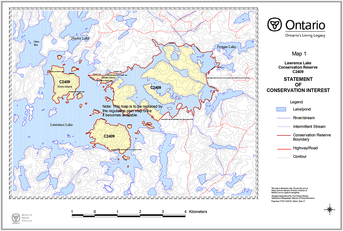
Map 2 - Lawrence Lake Conservation Reserve: Base features
Enlarge Map 2 - Lawrence Lake Conservation Reserve: Base features
Map 3 - Lawrence Lake Conservation Reserve: Recreational capability
Enlarge Map 3 - Lawrence Lake Conservation Reserve: Recreational capability
Map 4 - Lawrence Lake Conservation Reserve: Ecosites
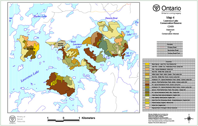
Enlarge Map 4 - Lawrence Lake Conservation Reserve: Ecosites
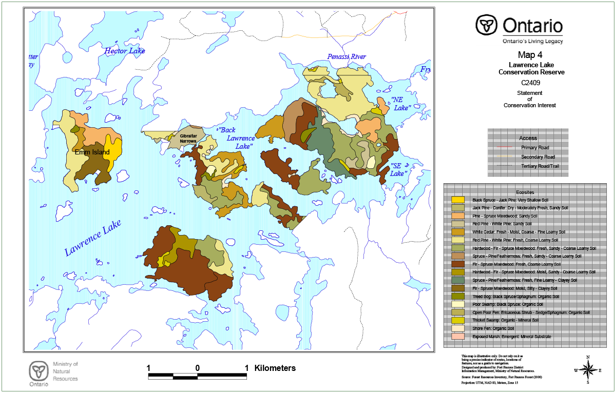
Map 5 - Lawrence Lake Conservation Reserve: Forest Cover

Enlarge Map 5 - Lawrence Lake Conservation Reserve: Forest Cover
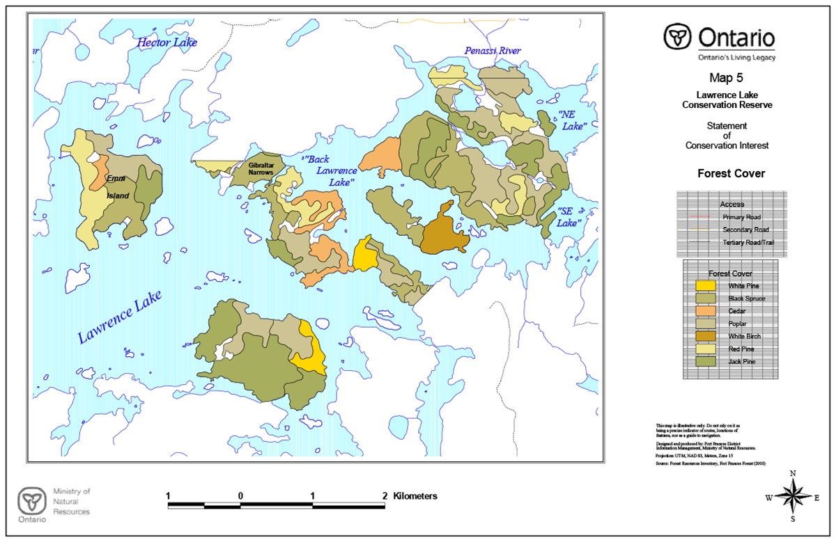
Appendix D: Forest stand listings
Lawrence Lake Conservation Reserve Statement of Conservation Interest: Summary of Forest Stands
Source: Forest Resources Inventory, Highrock Forest 1996 (updated to year 2000)
| Stand | Age | WG | Area | Year of update | HT | STKG | Site | Species | Primary ecosite | Mapsheet |
|---|---|---|---|---|---|---|---|---|---|---|
| 79900 | 95 | 33 | 0.0 | 2000 | 24 | 0.6 | 2 | PO 5PJ 2SB 2PR 1 | 21 | 154705450 |
| 25880 | 0 | 0 | 1.8 | 2000 | 0 | 0 | Non-forested | 0 | 154705450 | |
| 50890 | 102 | 7 | 0.9 | 2000 | 18 | 1.0 | 2 | PJ 8B 1SB 1 | 20 | 154705450 |
| 49870 | 70 | 11 | 21.2 | 2000 | 19 | 0.7 | X | PO 3SB 3PW 2PJ 1PR 1 | 15 | 154705450 |
| 27870 | 120 | 17 | 7.1 | 2000 | 14 | 0.8 | 2 | CE 6BW 2AB 1SB 1 | 17 | 154705450 |
| 72880 | 150 | 11 | 4.2 | 2000 | 11 | 0.5 | 4 | SB 0 | 34 | 154705450 |
| 81870 | 0 | 0 | 2.5 | 2000 | 0 | 0 | Non-forested | 0 | 154705450 | |
| 42870 | 90 | 4 | 7.2 | 2000 | 20 | 0.8 | 2 | PR 6PJ 2PO 1SB 1 | 18 | 154705450 |
| 87840 | 92 | 33 | 23.2 | 2000 | 24 | 0.8 | 2 | PO 7PJ 2B 1 | 19 | 154705450 |
| 89830 | 90 | 7 | 16.9 | 2000 | 19 | 1.0 | 2 | PJ 6PO 2SB 2 | 20 | 154705450 |
| 45870 | 0 | 0 | 0.7 | 2000 | 0 | 0 | Non-forested | 0 | 154705450 | |
| 33840 | 60 | 7 | 16.8 | 2000 | 15 | 0.9 | 3 | PJ 8PO 1SB 1 | 13 | 154705450 |
| 54810 | 70 | 4 | 22.9 | 2000 | 18 | 0.9 | 2 | PR 7BW 2B 1 | 18 | 154705450 |
| 44870 | 70 | 11 | 0.4 | 2000 | 19 | 0.7 | X | PO 3SB 3PW 2PJ 1PR 1 | 15 | 154705450 |
| 42860 | 70 | 11 | 1.0 | 2000 | 19 | 0.7 | X | PO 3SB 3PW 2PJ 1PR 1 | 15 | 154705450 |
| 84840 | 95 | 4 | 11.9 | 2000 | 18 | 1.0 | 3 | PR 6PJ 2PO 2 | 15 | 154705450 |
| 30820 | 60 | 11 | 34.8 | 2000 | 18 | 0.6 | X | SB 7PO 2BW 1 | 32 | 154705450 |
| 51820 | 90 | 11 | 13.2 | 2000 | 16 | 0.5 | 1 | SB 4PO 3B 1PJ 1PW 1 | 21 | 154705450 |
| 53850 | 0 | 0 | 0.9 | 2000 | 0 | 0 | Non-forested | 0 | 154705450 | |
| 67810 | 81 | 11 | 28.3 | 2000 | 17 | 0.5 | 1 | SB 5BW 2CE 1PO 1PR 1 | 21 | 154705450 |
| 79800 | 95 | 11 | 14.6 | 2000 | 22 | 0.8 | X | SB 8PJ 1PO 1 | 26 | 154705450 |
| 56830 | 100 | 17 | 19.0 | 2000 | 11 | 0.8 | 3 | CE 4PO 2SB 2BW 1PR 1 | 17 | 154705450 |
| 52830 | 0 | 0 | 0.5 | 2000 | 0 | 0 | Non-forested | 0 | 154705450 | |
| 86820 | 140 | 11 | 3.5 | 2000 | 16 | 0.8 | 2 | SB 0 | 35 | 154705450 |
| 74770 | 54 | 36 | 25.5 | 2000 | 14 | 0.8 | 3 | BW 5SB 4PO 1 | 19 | 154705450 |
| 80810 | 0 | 0 | 1.6 | 2000 | 0 | 0 | Non-forested | 0 | 154705450 | |
| 59810 | 0 | 0 | 1.3 | 2000 | 0 | 0 | Non-forested | 0 | 154705450 | |
| 53800 | 130 | 11 | 2.7 | 2000 | 12 | 1.0 | 3 | SB 0 | 35 | 154705450 |
| 83800 | 97 | 7 | 4.1 | 2000 | 22 | 0.9 | 1 | PJ 7PO 2B 1 | 20 | 154705450 |
| 53790 | 0 | 0 | 2.6 | 2000 | 0 | 0 | Non-forested | 0 | 154705450 | |
| 69790 | 0 | 0 | 0.6 | 2000 | 0 | 0 | Non-forested | 0 | 154705450 | |
| 56770 | 0 | 0 | 2.6 | 2000 | 0 | 0 | Non-forested | 0 | 154705450 | |
| 54760 | 65 | 33 | 24.1 | 2000 | 19 | 0.9 | 3 | PO 7PJ 1PR 1SB 1 | 19 | 154705450 |
| 81790 | 95 | 11 | 0.0 | 2000 | 22 | 0.8 | X | SB 8PJ 1PO 1 | 26 | 154705450 |
| 63740 | 95 | 1 | 11.1 | 2000 | 20 | 0.7 | 2 | PW 5PO 2SB 2CE 1 | 18 | 154705450 |
| 57750 | 155 | 17 | 19.3 | 2000 | 16 | 0.8 | 2 | CE 5PO 2SB 2BW 1 | 17 | 154705450 |
| 67730 | 80 | 11 | 15.8 | 2000 | 15 | 0.6 | 1 | SB 4CE 3B 1BW 1PO 1 | 21 | 154705450 |
| 51760 | 65 | 7 | 8.5 | 2000 | 15 | 1.0 | 3 | PJ 8PO 1SB 1 | 13 | 154705450 |
| 66720 | 80 | 33 | 11.0 | 2000 | 23 | 0.9 | 2 | PO 7CE 1SB 1SW 1 | 19 | 154705450 |
| 72710 | 95 | 33 | 0.4 | 2000 | 22 | 0.7 | 3 | PJ 4PO 4B 1SB 1 | 21 | 154705450 |
| 70700 | 80 | 33 | 4.0 | 2000 | 23 | 0.9 | 2 | PO 7CE 1SB 1SW 1 | 19 | 154705450 |
| 43650 | 90 | 7 | 28.5 | 2000 | 19 | 1 | 2 | PJ 4PO 2SB 2PW 1SW 1 | 20 | 154705450 |
| 48650 | 90 | 33 | 21.5 | 2000 | 21 | 0.9 | 3 | PO 6SB 2BW 1SW 1 | 23 | 154705450 |
| 52640 | 63 | 33 | 21.0 | 2000 | 17 | 0.8 | 3 | PO 4SB 4B 1BW 1 | 21 | 154705450 |
| 56610 | 75 | 1 | 14.9 | 2000 | 16 | 1.0 | 2 | PW 4PR 3PO 2SB 1 | 18 | 154705450 |
| 47600 | 70 | 7 | 68.2 | 2000 | 17 | 1.0 | 2 | PJ 7PO 2SB 1 | 20 | 154705450 |
| 43620 | 0 | 0 | 4.0 | 2000 | 0 | 0 | Non-forested | 0 | 154705450 | |
| 54570 | 112 | 7 | 19.3 | 2000 | 19 | 0.8 | 2 | PJ 5SB 2B 1BW 1PO 1 | 20 | 154705450 |
| 46886 | 0 | 0 | 0.1 | 2000 | 0 | 0 | Non-forested | 0 | 154705450 | |
| 46882 | 0 | 0 | 0.6 | 2000 | 0 | 0 | Non-forested | 0 | 154705450 | |
| 87852 | 0 | 0 | 3.6 | 2000 | 0 | 0 | Non-forested | 0 | 154705450 | |
| 74015 | 0 | 0 | 0.4 | 2000 | 0 | 0 | Non-forested | 0 | 154705460 | |
| 74000 | 95 | 4 | 6.7 | 2000 | 19 | 0.7 | 2 | PR 5PJ 2PO 2SB 1 | 18 | 154705460 |
| 82000 | 90 | 33 | 8.2 | 2000 | 20 | 0.9 | 3 | PO 3PR 2PW 2BW 1PJ 1SB 1 | 18 | 154705460 |
| 74010 | 0 | 0 | 0.8 | 2000 | 0 | 0 | Non-forested | 0 | 154705460 | |
| 75990 | 95 | 4 | 5.6 | 2000 | 19 | 0.7 | 2 | PR 5PJ 2PO 2SB 1 | 18 | 154705450 |
| 83980 | 90 | 33 | 13.7 | 2000 | 20 | 0.9 | 3 | PO 3PR 2PW 2BW 1PJ 1SB 1 | 18 | 154705450 |
| 79990 | 0 | 0 | 0.2 | 2000 | 0 | 0 | Non-forested | 0 | 154705450 | |
| 79970 | 0 | 0 | 8.9 | 2000 | 0 | 0 | Non-forested | 0 | 154705450 | |
| 79980 | 0 | 0 | 0.4 | 2000 | 0 | 0 | Non-forested | 0 | 154705450 | |
| 78950 | 95 | 33 | 30.9 | 2000 | 22 | 0.6 | 3 | PO 4PR 2B 1BW 1PW 1SB 1 | 18 | 154705450 |
| 75960 | 0 | 0 | 0.8 | 2000 | 0 | 0 | Non-forested | 0 | 154705450 | |
| 78920 | 95 | 7 | 12.8 | 2000 | 19 | 0.8 | 2 | PJ 5PO 2PR 2SB 1 | 18 | 154705450 |
| 88930 | 95 | 7 | 4.9 | 2000 | 19 | 1.0 | 2 | PJ 7PO 1PR 1SB 1 | 14 | 154705450 |
| 69910 | 111 | 11 | 22.9 | 2000 | 18 | 0.6 | 1 | SB 5PJ 4BW 1 | 20 | 154705450 |
| 84940 | 90 | 4 | 9.6 | 2000 | 17 | 1.0 | 3 | PR 7BW 1PO 1PW 1 | 18 | 154705450 |
| 72900 | 100 | 7 | 24.1 | 2000 | 20 | 0.8 | 2 | PJ 4BW 2PO 2SB 2 | 21 | 154705450 |
| 87920 | 0 | 0 | 2.5 | 2000 | 0 | 0 | Non-forested | 0 | 154705450 | |
| 75870 | 95 | 11 | 28.3 | 2000 | 19 | 0.4 | X | SB 4PO 3B 1BW 1PJ 1 | 26 | 154705450 |
| 76930 | 0 | 0 | 0.6 | 2000 | 0 | 0 | Non-forested | 0 | 154705450 | |
| 46910 | 102 | 7 | 13.1 | 2000 | 18 | 1.0 | 2 | PJ 8B 1SB 1 | 20 | 154705450 |
| 76900 | 0 | 0 | 2.3 | 2000 | 0 | 0 | Non-forested | 0 | 154705450 | |
| 24850 | 102 | 4 | 41.4 | 2000 | 19 | 0.5 | 2 | PR 5SB 3BW 1PO 1 | 18 | 154705450 |
| 29870 | 90 | 33 | 28.5 | 2000 | 20 | 0.4 | 3 | PO 3PJ 2SB 2BW 1CE 1PR 1 | 14 | 154705450 |
| 89880 | 90 | 33 | 15.7 | 2000 | 20 | 1.0 | 3 | PO 7B 1PJ 1SB 1 | 19 | 154705450 |
| 82910 | 0 | 0 | 2.4 | 2000 | 0 | 0 | Non-forested | 0 | 154705450 | |
| 65890 | 80 | 17 | 19.2 | 2000 | 11 | 0.3 | 2 | CE 4PO 3B 1BW 1SB 1 | 17 | 154705450 |
| 85890 | 95 | 7 | 16.0 | 2000 | 19 | 1.0 | 2 | PJ 7PO 1PR 1SB 1 | 14 | 154705450 |
| 80860 | 95 | 33 | 26.8 | 2000 | 24 | 0.6 | 2 | PO 5PJ 2SB 2PR 1 | 21 | 154705450 |
Appendix E: Lawrence Lake Conservation Reserve factsheet
August, 2000
Background
On July 16, 1999, the Ontario Government released the Ontario’s Living Legacy Land Use Strategy to guide the planning and management of Crown lands in central and parts of northern Ontario. A major part of the Ontario’s Living Legacy Land Use Strategy was a government intent to establish 378 new protected areas. This commitment marks the biggest expansion of provincial parks and conservation reserves in Ontario’s history.
The proposed Lawrence Lake Conservation Reserve is part of this significant expansion of Ontario’s protected areas system.
Size and location
The proposed Lawrence Lake Conservation Reserve is situated approximately 75 kilometres north of the Town of Fort Frances and consists of the major islands, peninsulas and associated waters of the eastern portion of Lawrence Lake, and from the northeast shoreline of Lawrence Lake eastward through to Frypan Lake. This site is approximately 1416 hectares in size.
Area highlights
Lawrence Lake is a deep coldwater lake trout lake located centrally to an area of high tourism value. The islands and peninsulas contain an abundance of white and red pine which contribute to the scenic and ecological qualities of this site. This site contains representative landform and vegetation types, including a variety of conifer, hardwood and mixed forests and an area burned by natural wildfire. The proposed Lawrence Lake Conservation Reserve has good potential for remote tourism, and recreational activities such as canoeing, wildlife viewing and camping. The area is not road accessible, but intervening waterways connect to the proposed Pipestone Conservation Reserve approximately 9 kilometres to the southwest.
Land use intent
Conservation reserves are areas of Crown land set aside by regulation under the Public Lands Act.
Conservation reserves complement provincial parks in protecting representative natural areas and special landscapes. Most recreational (e.g. hiking, skiing, tourism related uses, nature appreciation) and non-industrial (e.g. fur harvesting, commercial fishing and bait harvesting) activities that have traditionally been enjoyed in the area will continue, provided that these uses do not impact on the natural features needing protection. Hunting and fishing is permitted within all new conservation reserves proposed through Ontario’s Living Legacy.
Commercial timber harvesting, mining, aggregate extraction and commercial hydroelectric development are prohibited in conservation reserves. Careful mineral exploration may occur in specific new conservation reserves proposed through Ontario’s Living Legacy, in areas that have provincially significant mineral potential. If a portion of a new conservation reserve is to be developed for a mine, it would be removed from the reserve, and appropriate replacement lands would be placed in regulation.
Next steps
The Land Use Strategy established the Ministry’s intent to add these Crown lands to Ontario’s protected areas system, following the extensive public consultation associated with the Ontario’s Living Legacy and Lands for Life land use planning initiatives between 1997 and 1999. Prior to the finalization of the boundary of this conservation reserve proposed for regulation under the Public Lands Act, the Ministry is inviting public comment from August 15 – September 15, 2000 on the proposed boundary from all potentially affected stakeholders and First Nations.
In the interim, the area has been withdrawn and protected from resource extraction activities such as timber harvesting, hydroelectric development, aggregate extraction and new mineral exploration.
In the future and subject to the intended regulation of the area as a conservation reserve, the Ministry of Natural Resources will prepare a long term management plan for this area. Depending upon the complexity of issues within this conservation reserve, management planning may take the form of a simple Statement of Conservation Interest or a more detailed Resource Management Plan. Please let us know if you would like to be notified when planning begins.
Planning, management and the uses permitted within this conservation reserve would be consistent with the commitments of the Ontario’s Living Legacy Land Use Strategy.
For more information
For further information on the proposed Lawrence Lake Conservation Reserve, please contact John Munroe, Ministry of Natural Resources, 108 Saturn Avenue, Atikokan, Ontario, P0T 1C0, phone: (807) 597-6971 (ext. 241), Fax: (807) 597-6185. You may also visit the Ministry’s Internet website for information on Ontario’s Living Legacy.
Appendix F: Photographs
Photo 1: SE Lake from portage to Back Lawrence Lake.
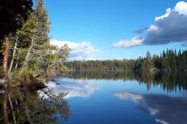
Photo 2: Penassi River at NE end of Back Lawrence Lake, looking upstream.
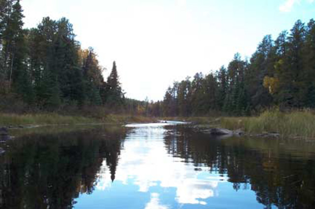
Photo 3: Back Lawrence Lake looking east from entrance to Gibraltar Narrows.
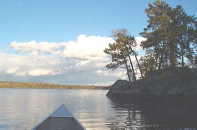
Photo 4: Rock scarp at N end of peninsula on Back Lawrence Lake.
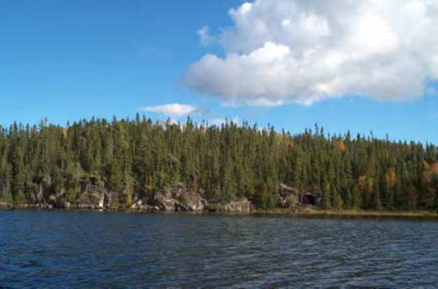
Photo 5: Typical low, rocky shoreline, Back Lawrence Lake.
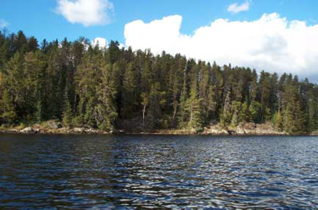
Photo 6: Aerial shot of NE Lake in foreground, looking west towards Back Lawrence Lake.
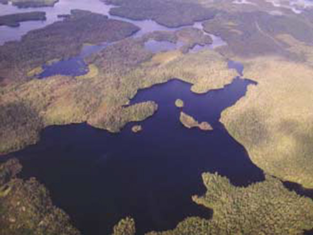
Photo 7: Gibraltar Narrows looking east towards Back Lawrence Lake.
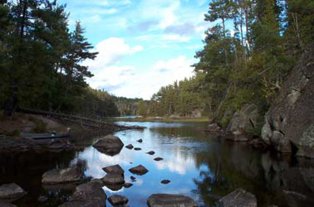
Photo 8: Mixedwood forest, Lawrence Lake Conservation Reserve.