Lola Lake Provincial Park Management Statement
This document provides policy direction for the protection, development and management of Lola Lake Provincial Park and its resources.
January, 1986
Regional Director’s approval statement
This Interim Management Statement will provide interim direction for the management of the Lola Lake Provincial Nature Reserve until a comprehensive Park Management Plan is prepared.
This statement will provide the basis for the subsequent preparation of the Park Management Plan.
I am pleased to approve this Interim Management Statement for the Lola Lake Provincial Nature Reserve.
D. R. Johnston
Regional Director
Northwestern Region
Introduction
The purpose of this Interim Management Statement is to identify:
- park values which are to be protected;
- resource management prescriptions necessary to protect these values; and
- restrictions on use of natural resources within the park.
This Interim Management Statement is not intended to replace a Park Management Plan. Rather it is intended to guide the use of natural resources and related activities within the park until such a time as a Park Management Plan is prepared.
The guidelines that have been developed are based on information contained in the Dryden District Land Use Guidelines.
Background information
- Name: Lola Lake
- Proposed class: Nature Reserve
- M.N.R district: Dryden
- M.N.R region: Northwestern
- Total area (ha): 6440
- Land:
- Water:
- Site region: 4S
- Site district: 4S-3
- Date in regulation: 85.01.24
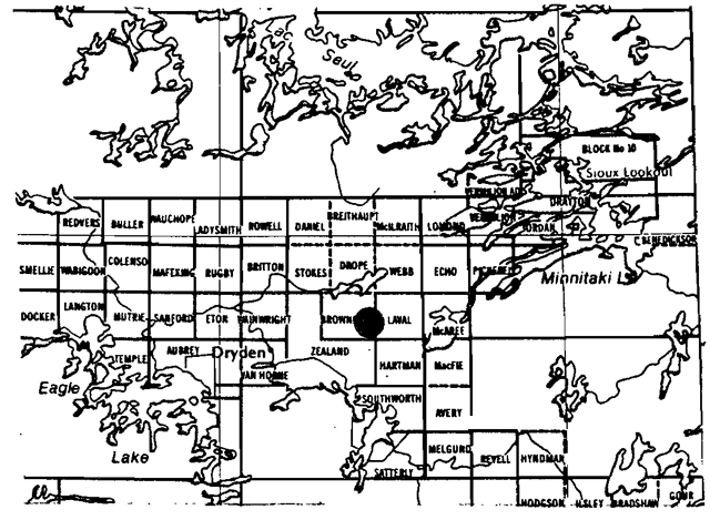
Regional setting map
Targets
- Life science representation
- Site type/landscape unit
- Extensive peatland on a lacustrine sand plain.
- An area of outwash and a small portion of the Hartman Moraine.
- Species/communities
- The peatland supports open and treed bog communities as well as ridge and pool patterns.
- Other portions of the park support pure and mixed stands of Sb, Pi, and Po.
- Site type/landscape unit
- Earth science representation
- Geological theme
- Representation of Landscape Unit 27Minnitaki Drift Complex
- Feature
- Good exposures of pillow lavas and representation of various elements of deglaciation in post-Hartman time.
- Geological theme
- Cultural resource representation
- Theme:
-
- n/a
- Theme segment:
-
- n/a
- Recreation opportunities
-
- day use: n/a
- car camping: n/a
- Wilderness/back country: n/a
-
| Level/Type | Earth science | Life Science | Cultural | Recreational | Other |
|---|---|---|---|---|---|
| Reconnaisance completion date | 1941, 1961, 1980 | 1977, 1981 | n/a | n/a | n/a |
| Detailed completion date | n/a | n/a | n/a | ||
| Required? | yes | yes | n/a | n/a | n/a |
Management guidelines
I Land tenure
There are presently no alienated forms of land tenure within the park however, a significant number of active mining claims are presently found throughout the park area.
Guidelines
Requests for any form of land tenure will not be considered pending the completion of the park management plan. Mining claims that revert to the Crown will automatically be included as part of the existing park.
II Land acquisition/disposition
There are no patent lands within the park but there are 493.5 acres (3 parcels) of patented land adjacent to the park boundary.
- N. Pt. Lot 5, Con.VI, Hartman Twp.
- parcel 4237 - 176 acres
Jefferson G. Sellers
Westmont, Illinois 60559 - S. Pt. Lot 9, Con.VI, Hartman Twp.
- parcel 6541 - 160 acres
George Ambros Dallimore (Estate)
c/o A.M. Dallimore
(Apt. 401-1111 Bonforts Blvd.)
Pueblo, Colorado 81001,
U.S.A. - S½Lot 12, Con. VI, Hartman Twp.
-parcel 6462 - 157.5 acres
Edeline Wetelainen
General Delivery
Wabigoon, Ontario
POV 2W0
Guidelines
It may be in the best interest of the Ministry to acquire these properties pending preparation of a park management plan.
If these properties come up for sale during the interim management period, the Province would like first right of refusal. Negotiations should be entered into with the present owners, during this interim plan period, to acquire this right. These three parcels comprise part of the peatland area as well
III Existing/proposed development
There is no existing development within the park boundary, with the exception of:
- A bulldozed right-of-way extending from the Gullwing Lake Road to the northwest side of Rafter Lake. This right-of-way is a result of a mineral exploration survey during the 1960's and is only passable by foot or all terrain vehicle; and
- A road extending thrpugh the southwest part of the park is passable by four-wheel drive and all terrain vehicle.
Guideline
The trail provides no easy access as the bulldozed right-of-way limits most vehicular traffic. The road through the southwest portion of the park extends from the Ministry of Natural Resources Dryden Tree Nursery where access is controlled by a permanent gate.
This trail and road are not considered to be a problem and no further restrictions will be placed on them pending completion of a park management plan. The intention will be to allow the road and trail to fall into disrepair unless they can be used for mineral exploration/extraction which would perhaps minimize further damage to the area.
Proposals for further development will not be considered pending the completion of the park management plan.
IV Recreation activities
Sport hunting for deer and moose occurs in and around the park in the fall (September-November) by local and non-resident parties. Sport fishing for warm and cold water species is present but considered to be light.
No boat cache decals of any kind have been issued to date within the park area.
Guideline
Due to limited access opportunities and restriction on any new development, existing recreational activities will be permitted to continue. If unforeseen conflicts develop in the future, necessary restrictions will be implemented. Of particular concern would be trail development for ATV's and snowmobiles.
Resource user and private boat caches will be permitted within the park area.
V Commercial activities
There are no commercial tourist activities within the park area.
Portions of the park fall within the Great Lakes Forest Products and Dryden Crown Management Unit licence areas.
Bait Fishing: The area is presently under licence to three (3) bait fishermen but the areas utilized by these bait fishermen have not been inventoried.
Trapping: Portions of two traplines (DR27 and DR26) fall within the park boundary, involving two licenced trappers and four helpers. One trapline cabin is located within the park area.
Mineral Exploration/Extraction: The area has a high mineral potential as evidenced by Goldlund Mine located 10 kms to the east. There is also significant peat potential.
There are no commercial boat caches within the park area. There is no known wild rice harvesting occurring in the park area.
Guideline
Commercial tourist development will not be permitted within the park.
Commercial forest operations will not be permitted. An Order-in-Council will be prepared to formally withdraw the park area from the above licence areas.
Existing bait fishing operations will be permitted to continue. Appropriate regulations under the Provincial Parks Act will be implemented.
Existing trapping activity will be permitted to continue but must be regulated under the Provincial Parks Act and Regulation. The cabin will be allowed to stay in its present location under agreement with the Ministry of Natural Resources. No additional cabins or relocations of the existing cabin will be permitted-within the park area.
Mineral exploration/extraction for metallic and non-metallic minerals will be permitted to continue subject to the conditions of an Exploratory Licence of Occupation (Section 190, R.S.O. of the Mining Act). Mineral exploration will be undertaken in such a way that does not conflict with future management options for the park or the protection of park values.
VI Natural resources
Guidelines
Natural fires will be allowed to burn undisturbed unless they threaten human life, lands outside the park, or values for which the park was established. Fires resulting from human causes will be suppressed. Fire suppression techniques used will have as minimal effect as possible on the park environment. Such means of suppression as bulldozing, and water bombing with chemical additives, will not be permitted except in critical situations.
Management of Wildlife will be directed to the maintenance of an evolving natural succession, unless alternative strategies are desirable.
Management of Vegetation will be directed to the maintenance of an evolving natural succession unless alternative strategies are desirable.
VII Research
More complete earth and life science inventories will be necessary prior to the preparation of a park management plan.
Lake Surveys will be required on both Rafter and Lola Lake prior to the preparation of a park management plan.
VIII Native interests
There are no known Native interests or claims within the park area.
IX Cultural resources
There are no known cultural resources within the park area.
Sources/references
Kor, P., 1980 - Earth Science Inventory Checklist Lola Lake Candidate (O.M.N.R.)
Noble, T., 1979 -Life Science Inventory Check-Sheet Lola Lake Candidate (O.M.N.R.)
O.M.N.R., 1983- Dryden District Land Use Guidelines
O.M.N.R., 1984- Impact of Peatland Development on Fish and Wildlife Habitat
O.M.N.R., 1982- Report of Task Force on Parks System Planning
Satterly, J., 1941 - Geology of the Dryden Wabigoon Area, Ontario Department of Mines, 50th Ann. Report, Vol. 1, Pt. 11, pg. 1-67
Thatcher, B., 1981- Life Science Inventory Check-Sheet, Lola Lake Peatland (O.M.N.R.)
Zoltai, S.C., 1961 -Glacial History of Part of Northwestern Ontario, Proc. Geol. Assoc. Can., Vol.13, pg. 61-83
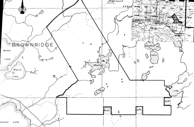
Map of Lola Lake Provincial Park
Lola Lake area
- Area description
- Located to the northeast of the Town of Dryden, the area has limited resource extraction and public recreation activity. This area forms part of the Great Lakes Forest Products’ licence area and the Dryden Crown Management Unit. Resource extraction activity consists primarily of mineral exploration, bait fishing, trapping and hunting. The area is some 6350 hectares in size.
- Land Use Intent
- This area is recommended for park status. The candidate park will provide for representation of the Minnitaki Drift Complex landscape unit.
Due to the size of the area and given the variety of uses that are ongoing within it, it is further recommended that most of the ongoing activities within the area be permitted to continue. The exception to this would be commercial logging which is not recommended as a continuing use. An outline of those ongoing activities which are recommended for continuation is given in the Land Use Activity section, however it must be realized that in some instances further refinement may be required.
- This area is recommended for park status. The candidate park will provide for representation of the Minnitaki Drift Complex landscape unit.
-
Land Use Activity for area No. 3-Lola Lake area
Land Use Activity for area No. 3-Lola Lake area Activity Acceptable
YesAcceptable
NoRecommended Guidelines Aggregate Extraction x Agriculture x Bait Fishing x It is recommended that existing bait fishing operations be permitted to continue. Commercial Fishing x Cottaging x Forestry x Hunting x It is recommended that hunting be permitted to continue. Mining x It is recommended that mineral exploration/extraction be permitted to continue. Provincial Parks x This area is recommended for park status. Roads x Rural Residential x Sport Fishing x It is recommended that sport fishing be permitted to continue. Tourism x Trapping x It is recommended that existing trapping activity be permitted to continue. Wildlife Viewing x Will continue. Wild Rice Harvesting x Urban Development x
Ontario nature reserves program - Life science inventory check-sheet: Lola Lake - Candidate Nature Reserve
- Name: Lola Lake - Candidate Nature Reserve
- Map name: Dryden Sandy Beach Lake
- Map number: 52F/15, 52F/16
- UTM ref.: 300200
- County, district or regional municipality: District of Kenora
- Lat: 49°50'N
- Long.: 92°35'W
- Alt. min: 370 m (1150)
- Alt. max.: 500 m (1550)
- Township:
- Brownridge
- Hartman
- Laval
- Zealand
- Lots:
- Concessions:
- Area:
- Option 1-32,620 acres /Option 1 – 13,200 ha
- Option 2 – 14,830 acres, Option 2 – 6000 ha
- Ownership: Crown (almost all)
- Administration
- Forest region and district: Boreal – Upper English River
- Site district: 4S – 3
- Map region and district: NWR – Dryden
- Conservation Authority:
- Aerial photographs:
Aerial photography base map Year Roll Flight line Numbers 1965 2 4937 145-150 1965 26 4936 156-167 1965 59,68,67 4935 56-60,227-231,189-193 1965 6 4934 76-82 1965 56,59 4933 102-103,88-92
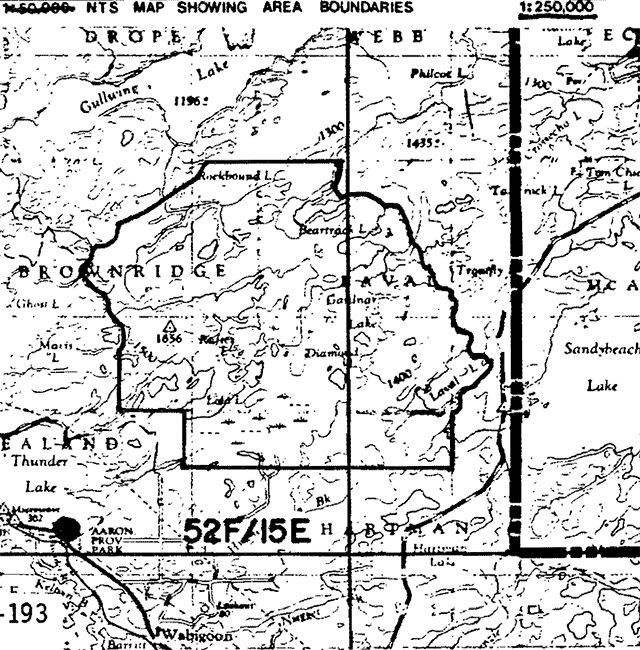
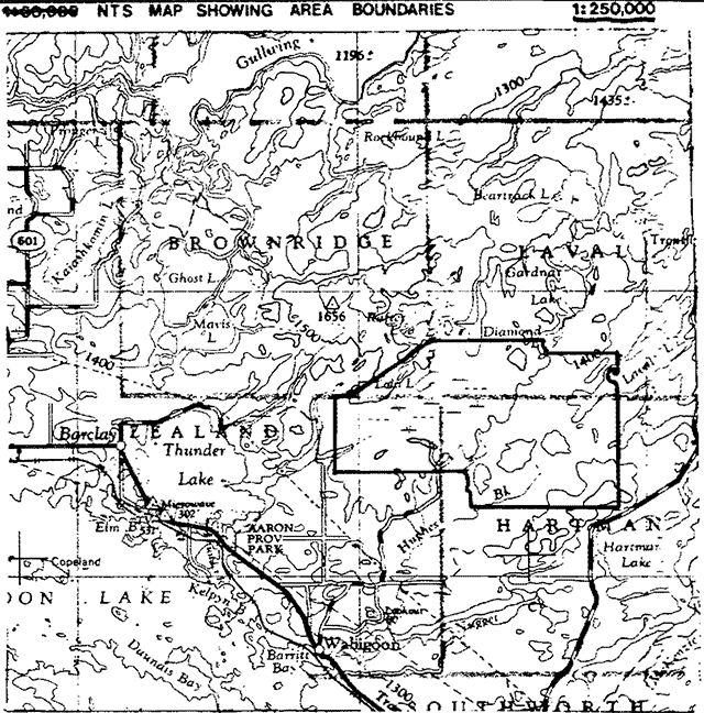
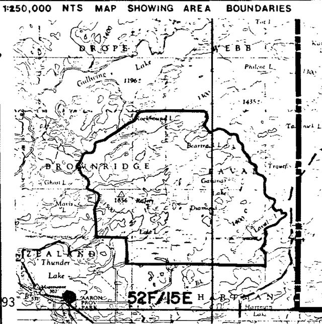
NTS map showing area boundaries of Lola Lake - Candidate Nature Reserve
Physical and biological features
An area with an extensive peatland on a lacustrine sand plain is located around Lola Lake. It was identified during the International Biological Program. To the east of the peatland is an area of outwash and a small portion of the Hartman Moraine. To the north of the peatland is an area of lacustrine sand and outwash sand, a bedrock ridge with a till mantle and an area of lacustrine fine sand and clay.
The peatland supports open and treed bog communities as well as ridge and pool patterns. Other sections of the candidate support pure coniferous (jack pine, black spruce), pure deciduous stands (trembling aspen) and mixed stands.
Two options have been outlined to incorporate the variety of features present and yet maintain protection of the essential features.
Data sheets attached
- Physical description n/a
- Vegetation summary n/a
- Evaluation sheet n/a
- Community description n/a
- Community component lists n/a
- Summary species lists n/a
- Physical features map n/a
- Vegetation map n/a
- Bibliography n/a
- Photographs n/a
Major information sources
None
Evaluation and priorities
This area of both earth and life science significance is strongly recommended as a nature reserve candidate.
Date compiled
1981.01.09
Compiler
B. Thacker
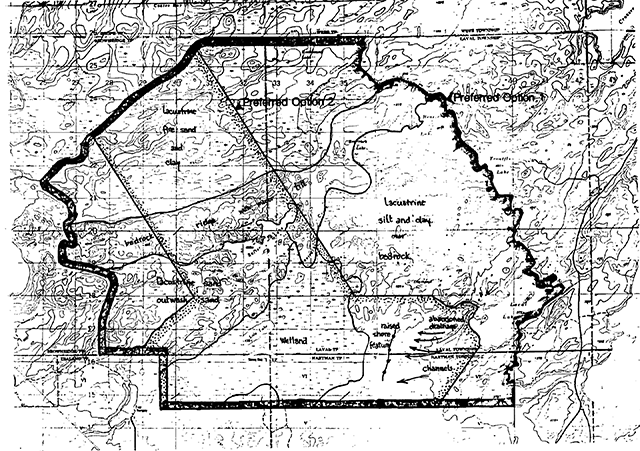
Map showing Preferred Option 1 (dark outline) and Preferred Option 2 (stippled outline), and the physiographicunits and specific features each option incorporates
(Scale - square grid pattern: each square is 1 km × 1 km.)
Ontario nature reserves program - life science inventory check-sheet: Lola Lake - Peatland/Sand Plain Complex
- Name: Lola Lake - Peatland/Sand Plain Complex
- Map name: Dryden
- Map number: 52F/15, 52F/16
- UTM ref.: 325165
- County, district or regional municipality:
- Lat: 49°48'N
- Long.: 92°33'W
- Alt. min: ±1385
- Alt. max.: ±1400
- Locality: Thunder Lake
- Township:
- Brownridge
- Zealand
- Laval
- Hartman
- Lots:
- Concessions:
- Area: 9648 acres; 3860 hectares
- Ownership: Crown/private (?)
- Administration: Ministry of Natural Resources
- Forest region and district: B.14 - L. Eng. R.
- Site district: 4S – 3
- Map region and district: NWR – Dryden
- Conservation Authority:
- Aerial photographs
Base map: 497923
Year Roll Flight line Numbers 1965 65 4933 10 to 13
NTS map showing area boundaries of Lola Lake - Peatland/Sand Plain Complex
Physical and biological features
The area delineated on the map is located northeast of Thunder Lake. It consists of an extensive peatland situated on a lacustrine sand plain and occurs as a complex with lacustrine sand terrain at the periphery. The combination of these two features are representative of two biophysical landscapes that are not widespread in the site region.
The peatland portion of this area supports numerous open and treed bog community types as well as ridge and pool patterns found in water tracks and raised bog with its radiating drainage pattern. The drainage pattern throughout the whole peatland is interesting for its directional variety.
The adjacent sand plain consists of lacustrine and outwash sands which support extensive stands of jack pine dominated closed coniferous forest. The lacustrine sands are probably outwash sands associated with the adjacent Hartmann end moraine that have been subsequently reworked by lake waters. Other features include a possible north-south trending shoreline ridge, with a proximal sand plain disected by incised drainage channels, eskers, small morainic ridges, a very small portion of end moraine, and some hummocky rockland.
Data sheets attached
None
Major information sources:
- Aerial Photographs; 1 inch = 1 mile; A13563 - 38 to 40
- Canadian National Directory for IBP Areas
Evaluation and priorities
This area has excellent representational potential and is worthy of preservation and was recommended for such under the International Biological Programme.
Date compiled
September 26, 1979
Compiler
T. Noble
The above observations have been interpreted from 1950's aerial photography (1 inch = 1 mile) and a brief aerial flight over the area. A field visit has not been made to this site. Given these qualifiers, it is thought the area has excellent preservation potential and was recommended as a candidate natural reserve under the International Biological Programme (see the lastest Canadian National Directory for IBP Areas).
| Temperature | Substrate | Arid | Very Dry | Dry | Dry Mesic | Mesic | Wet Mesic | Wet | Very Wet | Saturated | Open Water |
|---|---|---|---|---|---|---|---|---|---|---|---|
| Colder | Rock | ||||||||||
| Colder | Sand | ||||||||||
| Colder | Loam | ||||||||||
| Colder | Clay | ||||||||||
| Colder | Organic | B, C | C, D | D | D | ||||||
| Normal | Rock | ||||||||||
| Normal | Sand | A | A | A | |||||||
| Normal | Loam | ||||||||||
| Normal | Clay | ||||||||||
| Normal | Organic | C | C | ||||||||
| Warmer | Rock | ||||||||||
| Warmer | Sand | ||||||||||
| Warmer | Loam | ||||||||||
| Warmer | Clay | ||||||||||
| Warmer | Organic |
Lola Lake 52F/15E
- Closed Coniferous Forest
- lacustrine sands
- glacio-fluvial sands
- Bog
- open
- treed
- Swamp
- coniferous
- thicket
- Fen (?)
Note: This matrix indicates potential site type representation. There may be more site types than indicated here.
Field notes
- Field No.: 9-1 NWR
- Date: 1980.09.03
- Area name: Gullwing Lk. Area
- Location: 52F/15, 310257
- Feature: Pine Forest/Beaver Meadow
- Abiotic components:
- Slope - gently broken
- Aspect –
- Microclimate - normal
- Drainage - good, internal & surficial (v. slow current in creek)
- Substrate - fine sand over clay
- Biotic components - Vegetation composition by stratum:
- Tree - post fire young mature forest- Pj, occasional Po and young Sb.
- Shrub - Sb, Alnus rugosa, Ledum groenlandicum
- Herb - Aster macrophyllus, Rubus pubescens, Gaultheria procumbens, Linnaea borealis, Maianthemum canadensis, Goodyeara repens, Clintonia borealis, Cornus canadensis, Vaccinum myrtilloides, Diervilla lonicera, Lycopodium obscurum, L. lucidulum.
- Bryoid - Pleurozium carpet.
- Faunal notes - Ovenbird, Black-capped Chickadee, Blue Jay, Yellow-shafted Flicker.
- Incidental notes
- Post fire forest with Beaver Meadow in creek bottom.
- Flight over area 17 Sept 1980 – note 10 Sandhill Cranes in peatland S. of Lola Lk.
Lola Lake - Peatland/Sand Plain Complex
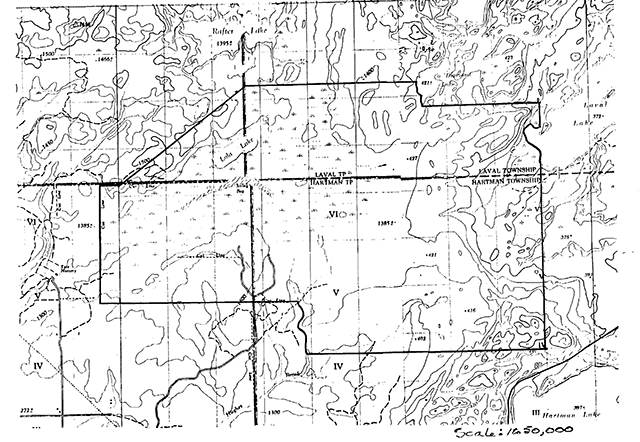
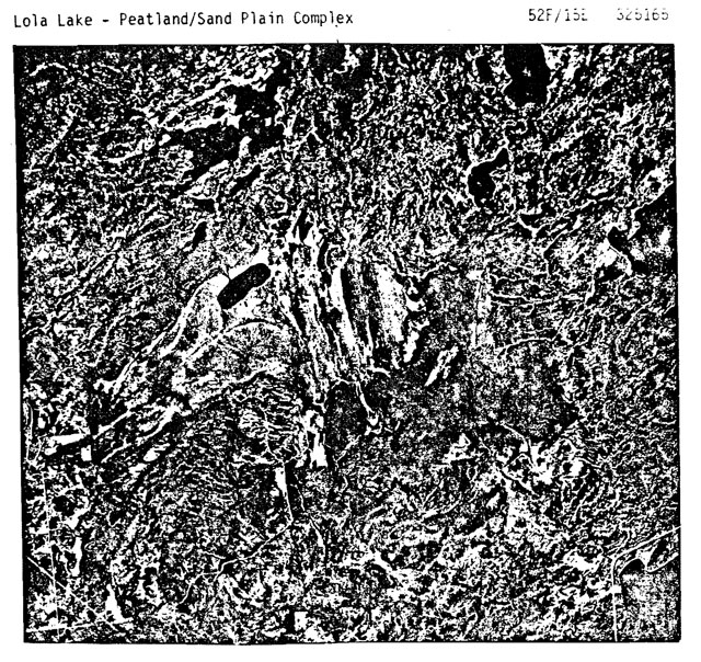 52F/15E 325165
Earth science inventory checklist: Lola Lake candidate
- Name: Lola Lake candidate
- Map name: Dryden Sandybeach Lake
- Map number:
52F 15
52f 16 - UTM reference: 300200
- County:
- Lat: 49°50'
- Long.: 92°35'
- Alt. min.: 370 m (1150 ft.)
- Alt. max.: 500 m (1550 ft.)
- Township: Brownridge, Zealand, Laval, Hartman
- Lot/ Concession: an area east of Ghost and Mavis L. south of Gullwing L. and west of Laval and Hartman L.
- Area: Option 1 - 32,620 ac. 13, 200 ha
Option 2 – 14,830 ac. 6000 ha - Ownership: Crown
- Administration:
- Map region and district: NWR – Dryden
- Conservation Auth.:
- Aerial photographs - base maps
Year Roll Flight line Numbers 1965 2 4937 145-150 1965 26 4936 156-167 1965 59,68,67 4935 56-60, 227-231, 189-193 1965 6 4934 76-82 1965 56,59 4933 102-103, 88-92
NTS map showing area boundaries of Lola Lake candidate
Earth science features
- thick sequence of volcanic and sedimentary rocks, with some igneous intrusions, within the Wabigoon Subprovince, Superior Province, Precambrian Shield
- good exposures of pillow lavas
- outwash deposits (silt, sand, gravel) related to Hartman Moraine
- portion of the Hartman Moraine
- lacustrine deposits (massive & varved clay) related to post-glacial inundation of Lake Agassiz; also wave-cut terrace in outwash deposits.
Sensitivity
- relatively sensitive to most forms of disturbance
- clays subject to erosion if denuded of vegetation or exposed
- silts and sands subject to wind erosion if denuded of vegetation or exposed
Significance
- good representational value of Minnitaki Drift Complex
- good exposures of pillow lavas, which are not common in Precambrian
- good representation of various elements of deglaciation in post-Hartman time.
Major references
- Satterly, 1941
- Zoltai, 1961
Date compiled
23 Oct. 1980
Compiler
P. Kor
Physical features:
Field work 3 Sept. 80, flight 17 Sept. 80
The candidate area incorporates the following terrain features:
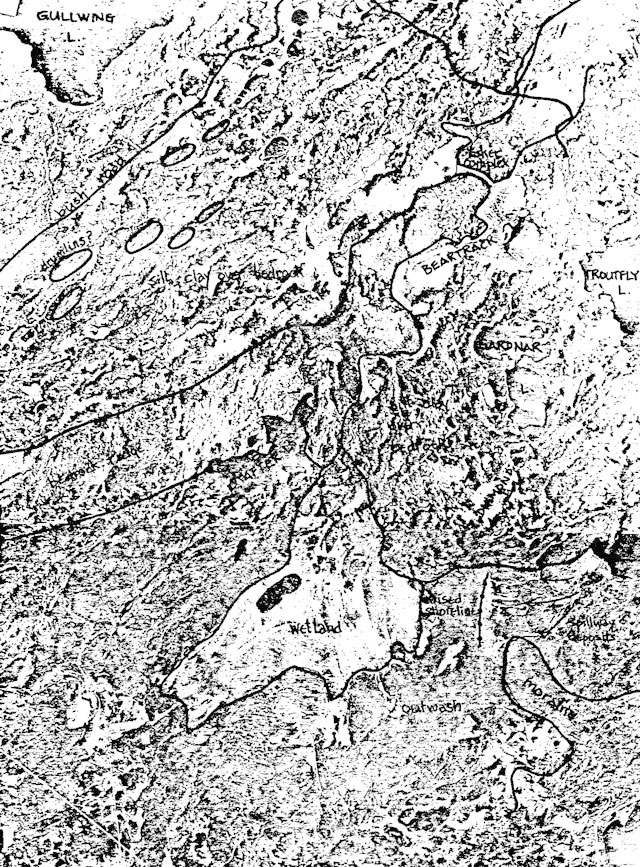
- The southern area is dominated by a relatively flatlying to gently rolling sand plain. Bedrock knolls are mantled by these lacustrine and outwash deposits, protruding only occasionally. An exceptional wetland surrounding Lola Lake is the dominant feature of this unit. A raised short feature, and distinct drainage rills from Laval Lake occur in the sand deposit due east of Lola Lake. The southern boundary of this landscape feature is marked by increasing relief from ice-contact deposits related to the Hartman Moraine.
- A portion of the Hartman Moraine protrudes into the outwash unit as a low, wide, indistinct hummocky ridge of coarse sand, gravel and boulders. Esker ridges along the crest of the feature indicate the presence of much water during the glacial melting along the moraine front. This abundance of water washed over the moraine as well, redistributing its deposits and thereby modifying its form. The raised shore feature described above (occurs at 52F16, UTM 362160, trending N-S for about 1.5 km) may well have initially formed on a portion of this moraine ridge.
- A dominant bedrock controlled ridge, rising up to 120m (370 ft.) above the surrounding terrain and probably mantled by stoney sand till or wave-washed bare, marks the northern boundary of the outwash unit. This ridge consists of a well-exposed 2700m (8000 ft.) thick sequence of steeply-dipping to vertical intermediate to predominantly basaltic metavolcanic rocks (Satterly, 1941, p.28). In the area east of Ghost and Mavis Lakes, at 30 bands of pillow lava occur intercalated with breccia bands, acidic pillow lavas, agglomerates, tuffs, and plagioclase amphibolites (Satterly, 1941, p.28). The bands are from 3m (10 ft.) to 30m (100 ft.) thick, averaging 10m (30 ft.), and exhibit excellent undeformed pillow structures with narrow, dark selvages (Setterly, 1941, p.10). Eastward towards Beartrack, Gardnar and Troutfly Lakes, local metamorphic grade is greater due to intrusive granitic bodies; this has destroyed much of the original volcanic structure of the belt. A very detailed description of all rock types within this unit is given by Satterly (1941).
- A lowlying area lies north of the bedrock ridge. The rolling terrain is underlain by metasedimentary rocks which occupy an 5800m (18,000 ft.) thick vertical sequence stratigraphically below the metavolcanic rocks (Satterly, 1941, p.27). Exposure is not extensive. Stream valleys display thick sequences of varved and massive clays, and a dendritic drainage pattern in these valleys is evident from the air. The stream system draining Rockbound Lake (52F15, UTM 335255) exhibits a particularly good example of drainage patterns through predominantly clay deposits. Near the bedrock knolls and the upper portions of some of the terrain irregularities, silts, sands and gravels were observed to lie at the surface. Some dunes were also noted east of Ghost Lake.
The bedrock features described in this checksheet lies near the northern boundary of the Wabigoon Subprovince, Superior Structural Province, Canadian Preambrian Shield. The surficial deposits represent lacustrine and outwash environments related to the Hartman Moraine phase of deglaciation, commencing roughly 10,100 B.P. The outwash deposits occur in association with the Hartman Moraine, whereas the lacustrine deposits occurred as a result of glacial Lake Agassiz inundating the lowlying areas to the north of the moraine as the ice cleared these areas. The lake waters washed bedrock knolls clear of drift, constructed the wave-cut terrace east of Lola Lake, redistributed the moraine deposits, and deposited thick sequences of massive and varved clays (Zoltai, 1961).
The study area incorporates elements of the deglacial environment of 10,000 years ago in a relatively undisturbed state.
Significance:
While no single feature within the candidate is spectacular, the area represents elements of the deglacial history of the region within a relatively small boundary. Broad landscape units have been developed for the administrative region (NWR), and the candidate has been identified as most adequately representing the Minnitaki Drift Complex Unit. The bedrock within the candidate is significant for its representation of a thick Precambrian volcanic-sedimentary sequence and exceptionally well preserved pillow structures within the volcanic rocks.
Recommendations:
It is recommended that the candidate area be incorporated within the parks system as a Nature Reserve in order to protect the fragile environment represented within the area. Most forms of disturbance will adversely affect the features within the candidate, thus requiring the strict protection of a Nature Reserve park classification.
Two options have been identified in the study area. Preferred Option 1 incorporates a complete range of the features described above within a 13200 ha (32620 ac.) Nature Reserve. Adequate representation of all units is assured by this boundary option. Preferred Option 2 is presented here as a minimum required area necessary to adequately represent most of the units described above. This second option basically removes the buffer zones required to protect the features from outside influences. The boundaries of both options attempt to minimize impact on other land uses (alienated land, logging, etc.), using to effect natural boundaries,such as rivers and lakes, and administrative boundaries, such as Township Lines.
References:
Satterly, J., 1941. Geology of the Dryden-Wabigoon Area. Ont. Dept. Mines, 50 Ann. Rep't, Vol.L, pt. II, p.1-67.
Zoltai, S.C., 1961. Glacial History of Part of Northwestern Ontario. Proc. Geol. Assoc. Can., V.13, p.61-83
Airphoto mosaic (scale 1 in.=1 mi.) showing general topographic features of the Lola Lake Candidate Nature Reserve area
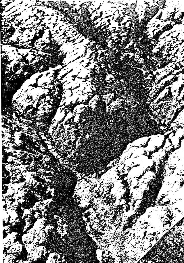
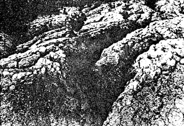
General view of eroded varved clay terrain; middle distance picture width about 3 m. Approx. UTM 257215
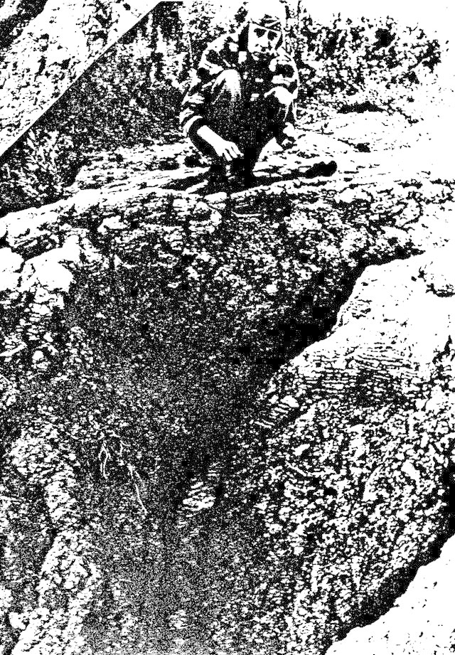
View of exposed varved clay, at least 1.5 m. deep. Approx. UTM 257215
General view showing varved clay topography after denudation and runoff water erosion. Varves can be seen in some exposed sections. UTM 257215
General view, looking southeast, showing raised shoreline and drainage pattern from Laval Lake. Approx. UTM 365160