Lowland Toothcup government response statement
Ontario’s policy direction for the protection and recovery of Lowland Toothcup.
Publication date: February 27, 2018
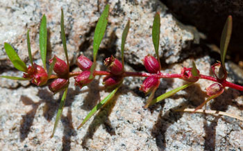
Photo: Sam Brinker
Protecting and recovering species at risk in Ontario
Species at risk recovery is a key part of protecting Ontario’s biodiversity. The Endangered Species Act, 2007 (ESA) is the Government of Ontario’s legislative commitment to protecting and recovering species at risk and their habitats.
Under the ESA, the Ministry of Natural Resources and Forestry (the Ministry) must ensure that a recovery strategy is prepared for each species that is listed as endangered or threatened. A recovery strategy provides science-based advice to government on what is required to achieve recovery of a species.
Within nine months after a recovery strategy is prepared, the ESA requires the Ministry to publish a statement summarizing the government’s intended actions and priorities in response to the recovery strategy. The response statement is the government’s policy response to the scientific advice provided in the recovery strategy. In addition to the strategy, the government response statement considered (where available) input from Indigenous communities and organizations, stakeholders, other jurisdictions, and members of the public. It reflects the best available local and scientific knowledge, including Traditional Ecological Knowledge where it has been shared by communities, as appropriate, and may be adapted if new information becomes available. In implementing the actions in the response statement, the ESA allows the Ministry to determine what is feasible, taking into account social and economic factors.
The Recovery Strategy for the Lowland Toothcup (Rotala ramosior) in Ontario was completed on June 15, 2017.
Protecting and recovering Lowland Toothcup
Lowland Toothcup is listed as an endangered species under the ESA, which protects both the plant and its habitat. The ESA prohibits harm or harassment of the species and damage or destruction of its habitat without authorization. Such authorization would require that conditions established by the Ministry be met.
Lowland Toothcup (also known as Toothcup) occurs in North, Central and South America and is at the northern limit of its range in Ontario and British Columbia, with less than 1% of the species’ global range occurring in Canada. Two designatable units for the species are described in the 2015 species status report of the Committee on the Status of Endangered Wildlife in Canada (COSEWIC), including the Great Lakes Plains designatable unit in Ontario (herein referred to as Lowland Toothcup) and the Southern Mountain designatable unit in British Columbia. The populations in Ontario are disjunct from other eastern North American Toothcup populations.
Lowland Toothcup has likely never been common in Ontario. Three populations of Lowland Toothcup have been reported in Ontario, of which one is considered extirpated. The two known populations are located along the southern edge of the Canadian Shield, in Lennox and Addington County in eastern Ontario. One population is in the Sheffield – Long Lake/Clare River area (located at Clare River and Sheffield Long Lake), and one is in the Puzzle Lakes area (located at Puzzle Lake West and Puzzle Lake East). Sites within populations are located on private land, conservation lands and in Puzzle Lake Provincial Park. The population recorded near St. Williams in Norfolk County is considered extirpated as this site was converted to pasture and cropland in the late 1980s.
Lowland Toothcup is an annual plant that is restricted to seasonally flooded shorelines of lakes, ponds and wet depressions. It grows in moist, shallow bedrock crevices filled with small accumulations of sand, gravel, mud and peat along lake and river shorelines. The sites are submerged early in the year, and plants emerge when water levels recede in summer months. The habitat conditions were different at the extirpated site in Norfolk County, where it grew in remnant sand prairie within moist old field habitat.
The abundance of mature individuals can fluctuate widely from year to year. As a result, a current population estimate for the species in Ontario does not exist. At one site in the Sheffield – Long Lake/Clare River population, the number of plants was estimated at 1,000-3,000 in 2004, but no plants were observed in 2011, while at another site, the number of plants went from 1,400 in 2004 to 305 in 2011. Large fluctuations have not been observed for the Puzzle Lakes population, which was estimated at 1,000 plants in 2011. The species is intolerant of shade and tends to decline in health and abundance when shaded by competing vegetation. Strongly fluctuating water levels within its habitat help to reduce competition from other species.
In Ontario, the main threats to this species are shoreline disturbance associated with waterfront development and recreational activities that can result in trampling and degradation of habitat. Current development impacts appear to be minor, but there is potential for further shoreline development. Given that one of the sites in the Sheffield – Long Lake/Clare River population is at a boat launch, there is potential for trampling by people and vehicles. Most of the larger lakes in the area where the species occurs have been modified to some degree by shoreline development or water control impoundments for flood control or navigation. Water levels that are artificially maintained at too-high or too-low levels, or prevented from fluctuating the required amounts at appropriate times can interfere with Lowland Toothcup’s ability to complete its life processes. Alteration of the hydrologic disturbance regime can also facilitate growth of competing vegetation.
Recovery efforts will focus on management of threats associated with development and recreational activities in the habitat of Lowland Toothcup populations, including those that may be identified through increased inventory and monitoring efforts. Actions to address threats posed by water levels are also important because changes to the natural flood regime within the species’ habitat may affect many or all individuals of a population. Increased awareness of the species and a collaborative approach amongst land owners, land managers and the public will support improved threat mitigation. Up to date information about location and abundance for all populations in Ontario will support implementation and evaluation of habitat management actions. Knowledge gained through research about the habitat conditions required to support Lowland Toothcup’s life processes will also contribute to the effectiveness of the actions.
Actions
Protecting and recovering species at risk is a shared responsibility. No single agency or organization has the knowledge, authority or financial resources to protect and recover all of Ontario’s species at risk. Successful recovery requires inter-governmental co-operation and the involvement of many individuals, organizations and communities. In developing the government response statement, the Ministry considered what actions are feasible for the government to lead directly and what actions are feasible for the government to support its conservation partners to undertake.
Government-supported actions
The government endorses the following actions as being necessary for the protection and recovery of Lowland Toothcup. Actions identified as “high” will be given priority consideration for funding under the ESA. Where reasonable, the government will also consider the priority assigned to these actions when reviewing and issuing authorizations under the ESA. Other organizations are encouraged to consider these priorities when developing projects or mitigation plans related to species at risk. The government will focus its support on these high-priority actions over the next five years.
Extended flooding or drying of Lowland Toothcup habitat can prevent germination, growth or flowering of the plant. Recognizing the species’ need for dynamic water levels, habitat management actions related to water levels (e.g., enabling natural or artificial flooding of habitat) may be needed to maintain suitable hydrological conditions for the species. Shoreline development and recreational activities in or near sites occupied by Lowland Toothcup can lead to trampling or other impacts, such as shading (e.g., by docks, boathouses or boats pulled ashore for storage). Implementing actions to reduce these threats will prevent inadvertent harm and help to maintain the suitability of the habitat for the species. Land owners and visitors to the area may not be aware of the ways that recreational activities can impact rare plants such as Lowland Toothcup, especially in small areas where the species could be overlooked. Raising awareness of the presence of the species will help to reduce the risk of trampling and may encourage land owners and land managers to take a stewardship approach to shoreline developments such as docks or landscaping.
Actions:
- (High) Encourage land owners and land managers to implement approaches to reduce the impacts of shoreline development and recreational activities on Lowland Toothcup and its habitat (including areas where the species may be present only as seed). Approaches may include:
- redirecting shoreline developments (e.g., docks, structures or boat storage) and recreational activities (e.g., trails) away from the habitat of the species;
- installing signage to alert land users to the presence of the species and, where necessary and appropriate, installing physical barriers (e.g., fencing) to prevent trampling by humans or vehicles; and,
- installing signage to alert boat operators to the presence of the species and the need to minimize boat wake and avoid dragging boats ashore in the habitat of the species.
- (High) Work collaboratively with land owners and land managers, in cooperation with the municipality, to develop, implement and evaluate habitat management plans to enable suitable water level fluctuations (natural or artificial) to occur in the species’ habitat, at appropriate times for the species, where feasible.
- Promote awareness among landowners, land managers and land users, about Lowland Toothcup by sharing information on:
- how to identify the species;
- the species' habitat requirements;
- protection afforded to the species and its habitat under the ESA; and,
- actions that can be taken to avoid or minimize impacts to the species and its habitat.
A challenge in surveying for Lowland Toothcup is that the number of mature individuals of this annual species may fluctuate at each site between survey years. In some years, the species may be present only as seed. In the Puzzle Lakes area, most large and accessible lakes have been surveyed, but some areas of suitable habitat have not been surveyed due to inaccessibility and private property limitations. Priorities for additional targeted surveys include areas east of Puzzle Lake to Kingston, along the southern edge of the Canadian Shield, in areas with low nutrient, gently sloping shorelines and naturally fluctuating water levels. While it is unlikely that Lowland Toothcup persists in Norfolk County, there are a few areas of private land in the St. Williams – Turkey Point – Walsh area where the species could occur. Where possible, surveys should be conducted over multiple years to support interpretation of trends and coordinated with surveys for other rare plant species known to occur in Lowland Toothcup habitat.
Actions:
- (High) Work collaboratively with land owners, land managers and researchers to develop, implement and evaluate standardized survey and monitoring protocols, which take into account the differences in the ability to detect plants at different life stages, to:
- conduct targeted surveys for Lowland Toothcup during low water years where populations occur and in nearby areas with suitable habitat conditions; and,
- conduct regular monitoring of populations to assess population trends, including abundance, extent of occurrence, demographic variability (e.g., seed bank size versus mature plant abundance) and health. Compare data with habitat conditions and the presence and significance of threats to the species.
- Identify additional sites with potentially suitable habitat conditions for the species to be surveyed, as informed by studies of the species’ biology and required habitat conditions.
- Conduct targeted surveys, in collaboration with land owners and land managers, to determine whether Lowland Toothcup persists in areas with suitable habitat conditions near the site of the extirpated population in Norfolk County.
Research on the species’ demography and population dynamics is needed to support the development of survey and monitoring protocols for the species. The absence of this species in apparently suitable habitat near occupied sites in the Puzzle Lakes area raises questions about how this species disperses to new habitat and whether other factors are affecting its establishment in these areas. Knowledge of the species’ dispersal mechanisms will assist in identification of areas connected to occupied sites that should be surveyed. Information on the species’ seed ecology will help to determine whether viable seeds may exist in areas where the species has been reported, but conditions for growth have since been unfavourable (e.g., sustained high water levels).
Studies of Lowland Toothcup’s biological and habitat requirements are also needed to inform threat mitigation actions and identify any additional limiting factors. Detailed information on the effects of water level fluctuations and other threats on the species will support effective threat management (e.g., appropriate water level controls), as appropriate.
Actions:
- Conduct research on Lowland Toothcup biology, including studies of:
- population dynamics and viability;
- seed ecology (e.g., dispersal mechanisms and distance, duration of viability, germination requirements); and,
- floral biology (e.g., dependence on insect pollination).
- Conduct studies to better understand the habitat conditions required by Lowland Toothcup and methods to improve habitat conditions, including:
- the effects of within- and between-year water level fluctuation on Lowland Toothcup during all life processes (e.g., germination) and the relationship between water levels (e.g., location, level, timing, and duration of flooding) and abundance at all sites;
- the potential effects associated with disturbance of forest ecosystems inland from occupied habitat (e.g., erosion, sedimentation, invasive species); and,
- the feasibility of methods to improve habitat conditions at sites where there is a direct threat to the species, such as restoring suitable hydrologic disturbances (natural or artificial) or removal of competing vegetation.
Implementing actions
Financial support for the implementation of actions may be available through the Species at Risk Stewardship Program. Conservation partners are encouraged to discuss project proposals related to the actions in this response statement with the Ministry. The Ministry can also advise if any authorizations under the ESA or other legislation may be required to undertake the project.
Implementation of the actions may be subject to changing priorities across the multitude of species at risk, available resources and the capacity of partners to undertake recovery activities. Where appropriate, the implementation of actions for multiple species will be co-ordinated across government response statements.
Reviewing progress
The ESA requires the Ministry to conduct a review of progress towards protecting and recovering a species not later than five years from the publication of this response statement. The review will help identify if adjustments are needed to achieve the protection and recovery of Lowland Toothcup.
Acknowledgement
We would like to thank all those who participated in the development of the Recovery Strategy for the Lowland Toothcup (Rotala ramosior) in Ontario for their dedication to protecting and recovering species at risk.
For additional information:
Visit the species at risk website at ontario.ca/speciesatrisk
Contact your MNRF district office
Contact the Natural Resources Information and Support Centre
NRISC@ontario.ca
ontario.ca/mnrf