MacMurchy Township End Moraine Provincial Park Management Statement
This document provides policy direction for the protection, development and management of MacMurchy Township End Moraine Provincial Park and its resources.
Interim Management Statement
Approval statement
I am pleased to approve this Interim Management Statement for MacMurchy Township End Moraine Provincial Park (P1591). Ontario’s Living Legacy Land Use Strategy (OMNR 1999) identifies this area as a provincial nature reserve. MacMurchy Township End Moraine Provincial Park was regulated November 22, 2002 (O. Reg. 311/02) under the Provincial Parks Act.
This Interim Management Statement provides direction for the protection and custodial management of MacMurchy Township End Moraine Provincial Park.
Signed by:
Paul Bewick
Zone Manager
Northeast Zone
Ontario Parks
Date: June 12, 2006
1.0 Introduction
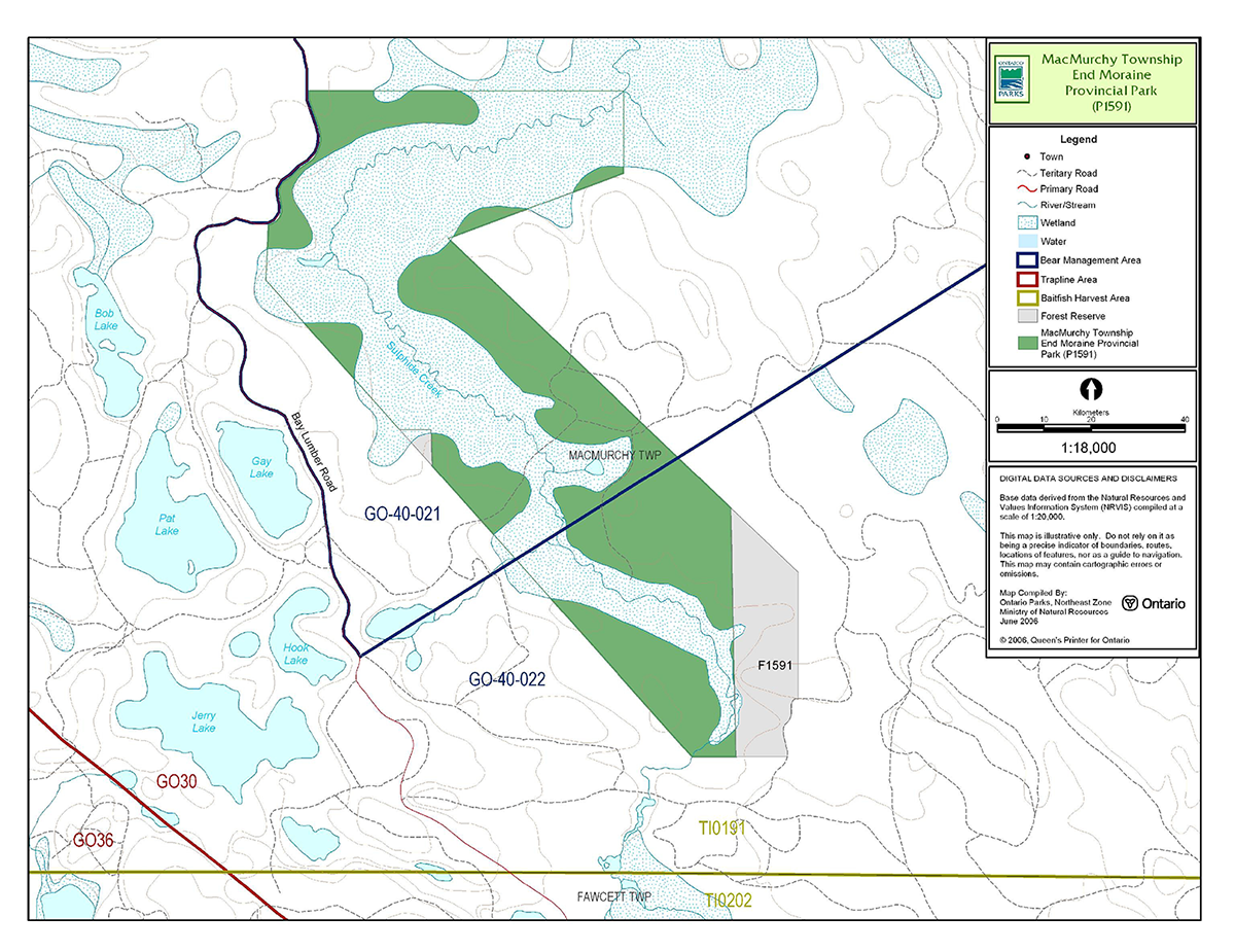
MacMurchy Township End Moraine Provincial Park is located approximately 45 kilometres east of Gogama and approximately 28 kilometres west of Gowganda (Figure 1).
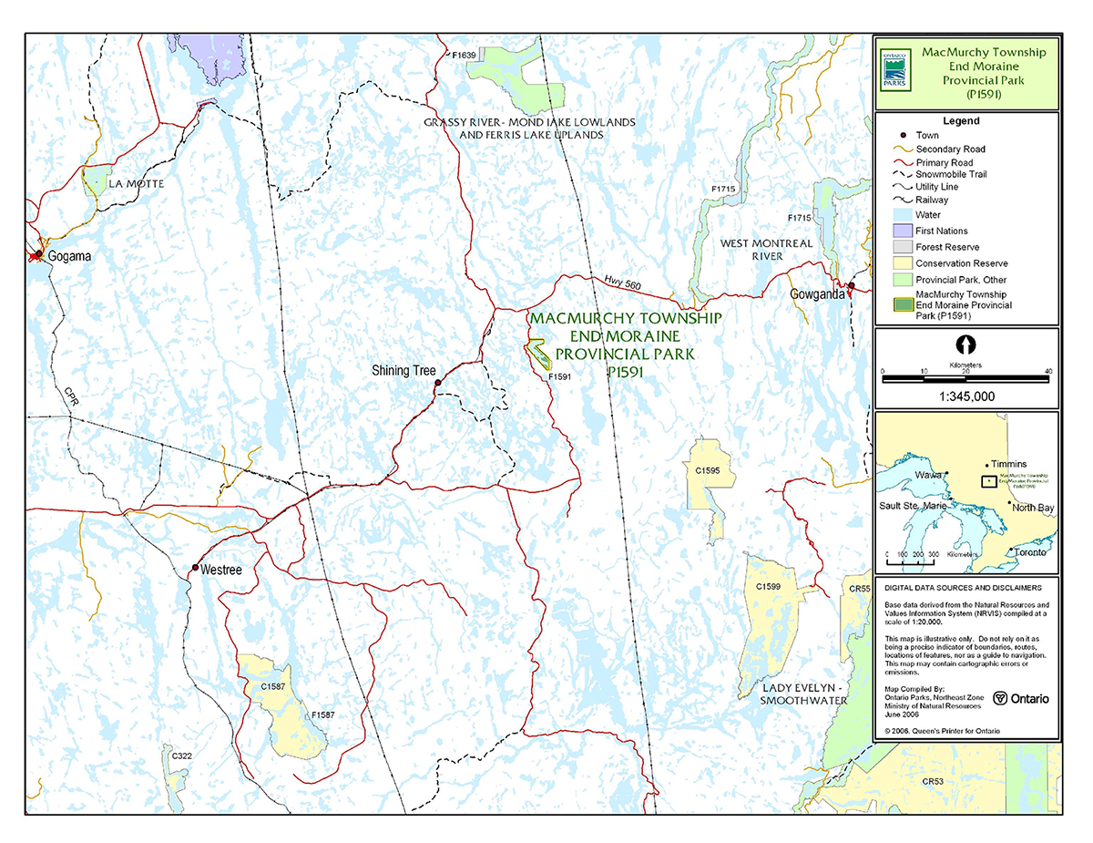
MacMurchy Township End Moraine Provincial Park contains of Crown land (Figure 2).
Adjacent to the regulated park boundary is an area that has been designated as a forest reserve (F1591)(Section 5.1.5).
This 23-hectare nature reserve class provincial park contributes to the Ontario Provincial Parks system by representing the distinctive natural habitats and landforms of this part of the province, and may provide education and research opportunities which will benefit present and future generations.
1.1 Objectives
The purpose of this Interim Management Statement (IMS) is to provide direction to ensure the custodial management of park resources. Future park planning may be undertaken as required to provide direction on significant decisions regarding resource stewardship, development, operations and permitted uses.
MacMurchy Township End Moraine Provincial Park will be managed consistent with the two main objectives for nature reserve class provincial parks:
Protection: To protect provincially significant elements of the natural and cultural landscapes of Ontario.
Heritage Appreciation: To provide opportunities for exploration and appreciation of the outdoor natural and cultural heritage of Ontario.
2.0 Management context
Park management will follow direction from:
- Provincial Parks Act (1990) and regulations
- Ontario’s Living Legacy Land Use Strategy (OMNR 1999), policy clarification amendments (OMNR 2000) and related direction
- Ontario Provincial Parks Planning and Management Policies (OMNR 1992) and updates
- Crown Land Use Policy Atlas (OMNR 2004a)
In addressing custodial management obligations to protect park values and ensure public health and safety, Ontario Parks will ensure that policy and Environmental Assessment Act (1990) requirements are implemented.
2.1 Environmental assessment
As part of the Ontario Ministry of Natural Resources (MNR), Ontario Parks is a public sector agency which is subject to the Environmental Assessment Act. Management of this park will be carried out in accordance with legislation, policies and MNR's A Class Environmental Assessment for Provincial Parks and Conservation Reserves (OMNR 2005a).
Figure 1: Regional Setting
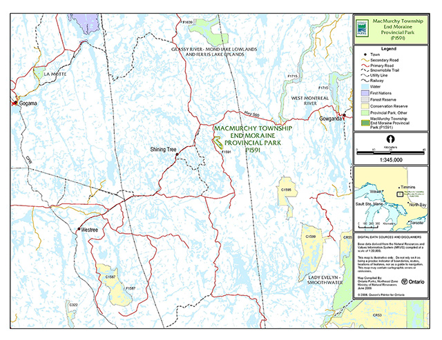
Enlarge Figure 1: Regional Setting
Figure 2: Park Boundary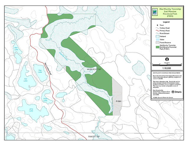
Enlarge Figure 2: Park Boundary
3.0 Park features and values
MacMurchy Township End Moraine Provincial Park is located in the MNR Administrative District of Timmins. The park straddles the boundary between ecodistrict 3E-5 and 4E-4.
3.1 Geological features
MacMurchy Township End Moraine Provincial Park is a very small, low relief area of broken end moraine. The park contains bedrock exposures consisting of pillowed dacite to andesite lava flows, and tuffs of the Cabot-Calvin supracrustal assemblage, components of the south central Abitibi Subprovince in the Archean Superior Province (Frey and Duba 2002).
MacMurchy Township End Moraine Provincial Park contributes to the conservation of the "Early Archean Basement" and the "Late Archean Volcanic Islands and Sedimentary Basins" Precambrian environment themes (Frey and Duba).
3.2 Biological features
The dominant landform-vegetation types are the weakly broken end moraine covered with sparse, mixed coniferous, mixed deciduous, dense conifer forests, and wetlands. An analysis of digital forest resource inventory (FRI) data was used to obtain quantitative estimates of Ecosite representations. Six Ecosites were identified within the park: one major (poor coniferous), four modest (open wetland, intolerant hardwoods, intolerant hardwoods-conifers, and moderate conifers), and one small (brush and alder) Ecosites occur in this provincial park. Black spruce is the dominant forest tree species in this park (Alkins 2003).
3.3 Cultural setting
A detailed survey and analysis of the cultural history and features of this park has not been completed to date.
Any future planning will be within the context of a provincial framework, A Topical Organization of Ontario History (OMNR 1974). In addition, updates and discussions with First Nations, other agencies and stakeholders may be carried out to identify cultural heritage values and features within the park and their significance. This information may be used to develop management guidelines to conserve and protect representative archaeological and historical values and features, or to provide direction for further research.
3.4 Recreation
The protection and maintenance of environmental quality and values are fundamental to the management of MacMurchy Township End Moraine Provincial Park. The intent of nature reserve class parks is to ensure that the natural resource values for which the park was designated are protected. As such, only low-intensity, day-use recreational activities will be permitted.
Existing or potential recreational activities, identified in the recreation assessment (Carré 2002) for this park, include bird watching, canoeing, nature appreciation, photography, and drawing or painting.
Hunting occurred in the park prior to its designation and regulation. However, the nature reserve classification of this park prohibits this activity (Section 6.1).
4.0 Aboriginal interests
MacMurchy Township End Moraine Provincial Park is located within the Nishnawbe Aski Nation (NAN) Treaty #9 (1905-06) area and southeast of Mattagami Indian Reserve.
First Nations were consulted regarding the regulation of this park from 2000 to 2002. It was determined that there were no issues with the regulation of MacMurchy Township End Moraine Provincial Park.
First Nations have expressed interest in and have shared knowledge of the park and surrounding area. Aboriginal communities have used the area for hunting, trapping, fishing, gathering and travel. These uses may continue, subject to public safety, conservation and other considerations.
Any communications and cooperation between Aboriginal communities and the MNR for planning and operations purposes will be done without prejudice to any future discussions or negotiations between the government of Ontario and Aboriginal communities.
5.0 Stewardship policies
The removal, damage or defacing of Crown properties, natural objects, relics and artifacts is not permitted in provincial parks (Provincial Parks Act).
5.1 Terrestrial ecosystems
5.1.1 Vegetation
Harvesting
Commercial forest harvesting and renewal activities are not permitted within the park (OMNR 1992).
The harvest of non-timber forest products such as club moss, Canada yew, etc., will not be permitted within the park (OMNR 1992).
There are no fuel wood cutting permits currently issued for MacMurchy Township End Moraine Provincial Park. New permits will not be issued (OMNR 2000).
Non-native plants
Non-native plant species will not be deliberately introduced into MacMurchy Township End Moraine Provincial Park. Where non-native plant species are already established, and threaten park values, a strategy to control the species may be developed (OMNR 1992).
Insects and disease
Insects and disease may be managed where the aesthetic, cultural, and/or natural values of MacMurchy Township End Moraine Provincial Park are threatened (OMNR 1992).
Control measures will follow guidelines established by the Ontario Ministry of the Environment (MOE) and MNR. Whenever possible, biological control measures will be given preference over the use of chemicals (OMNR 1992).
Fire
MacMurchy Township End Moraine Provincial Park is located within the Boreal Zone for fire management. In accordance with existing provincial park policy and the Forest Fire Management Strategy for Ontario (OMNR 2004b), forest fire protection will be carried out in the park as on surrounding lands.
Whenever feasible, MNR's Forest Fire Management program will use techniques that minimize damage to the landscape, such as limiting the use of heavy equipment or limiting the number of trees felled during response efforts (OMNR 2004b).
5.1.2 Wildlife management
MacMurchy Township End Moraine Provincial Park is located in Wildlife Management Unit (WMU) 40. The removal and harassment of non-game animals is not permitted in provincial parks (Provincial Parks Act).
Hunting
Hunting is not permitted within nature reserve parks (OMNR 1992).
The harvesting of bullfrogs and snapping turtles is illegal in provincial parks.
Bear management areas
Prior to park regulation, portions of two licensed bear management areas (BMA) (GO-40-21 and GO-40-22) overlapped the park boundary (Figure 3). This use is not permitted in nature reserve parks. The portions of these BMAs located within the regulated park boundary have been withdrawn from the licenses. New BMA licences will not be permitted (OMNR 1992; 1999; 2000).
Trapping
There is one trap line area (GO-30) which overlaps a portion of the park (Figure 3). This trap line is currently allocated for use. Since commercial fur harvesting is not permitted in nature reserve parks, the portion of the trap line within the regulated park boundary will be removed from the trap line license. No new operations will be permitted within the park (OMNR 2004a).
5.1.3 Industrial resources
There are no existing mining claims within the park boundary. Peat development, mineral exploration and/or mineral extraction are not permitted. Aggregate extraction is not a permitted in provincial parks(OMNR 1992, OMNR 2000).The mining and surface rights on all lands within the park have been withdrawn from staking under the Mining Act (1990).
5.1.4 Access and crossings
Access
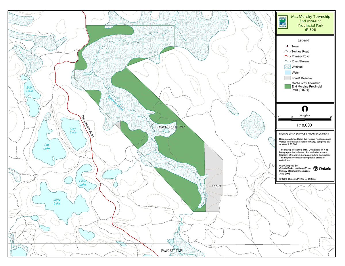
The park is accessed by tertiary roads from Bay Lumber Road on the west side of the park.
Roads
Bay Lumber Primary Road runs adjacent to the north-western boundary of the park (Carré 2002).
One road crosses the south central area of the park. The use and condition of this road is not currently known (Alkins 2003). This road crosses over Sulphide Creek (there is no bridge).
A road runs along the south-eastern boundary of forest reserve F1591, which is adjacent to the south-east side of the park boundary.
Where existing forest access roads are essential for continued access beyond the park for forest management or recreation purposes, and alternative road access does not exist, or road relocation is not feasible, existing roads will continue to be available for access. Continued use will include maintenance and may include upgrade (OMNR 2004a). Ontario Parks is not responsible for the maintenance or upgrade of any roads within the park boundary.
Any proposed development, maintenance or upgrading of existing roads must meet all Environmental Assessment Act requirements.
Figure 3: Bear Management Areas, Trap Line Areas, and Commercial Baitfish Harvesting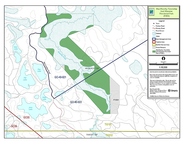
Enlarge Figure 3: Bear Management Areas, Trap Line Areas, and Commercial Baitfish Harvesting
Utility corridors
There are no utility corridors located within the boundary of the park.
All public utilities (e.g. gas pipelines, transmission lines, communications towers) must avoid park lands wherever possible. New utility corridor crossings may be necessary to maintain essential public services (OMNR 2004a).
Any future utility corridors proposed through the park, where park lands are unavoidable, will be reviewed on a case-by-case basis. Protection of park features and values will be priority and all requirements of the Environmental Assessment Act will be met.
Recreational trails
There are currently no authorized trails within the park boundary. New trails (e.g. hiking) may be developed if the need arises. Any proposed development within the park is subject to Environmental Assessment Act requirements.
5.1.5 Adjacent land management
Forestry
The area surrounding MacMurchy Township End Moraine Provincial Park is currently located in the Shiningtree Forest Management Unit (FMU), which will be incorporated in to the Timiskaming FMU upon the implementation of the renewed forest management plan (FMP) in 2006. The Timiskaming FMU is management by the Timiskaming Forest Industry Alliance (OMNR 2005b).
Forest reserve
Forest reserves (FR) are areas where protection of natural heritage and special landscapes is a priority, but some resource use can take place with appropriate conditions. Policies for FRs are similar to policies for new conservation reserves, except that mining and related activities are allowed in a forest reserve. Commercial forest harvest, new hydroelectric power development, and peat extraction are allowed, but most other resource and recreation uses will be permitted, provided they are consistent with the features and values being protected (OMNR 1999).
Adjacent to the south-eastern park boundary is a designated FR (F1591) which consists of an active mining claim. This land is not included in the regulated area of the park. As described in the proposed strategy for FRs (OMNR 2005c), this FR designation will be removed from all mining lands at the site, and will be redesignated as a General Use Area or an Enhanced Management Area (as appropriate).
General use areas
The Gogama Resource Area General Use Area surrounds the park.
The Gogama Resource Area is 429,834 hectare in size. This area is accessible by Highways 144 and 560 as well as numerous gravel roads. Structural development includes: cottages, hunt and fish camps, waste disposal sites, commercial resorts, outpost camps, access points, aggregate pits, an Ontario Ranger’s camp, a transformer station and several transmission lines. The primary activity in the area will be sustained yield timber production and mineral exploration and development.
5.1.6 Land disposition
MacMurchy Township End Moraine Provincial Park is located entirely within MacMurchy Township. New land disposition for the private use of individuals or corporations will not be permitted (OMNR 1992; 2000).
Land use permits, licenses of occupation, and unauthorized occupations
There are no existing land use permits (LUP), licenses of occupation or known unauthorized occupations within the park.
Patent land
There is no patent land located within MacMurchy Township End Moraine Provincial Park.
Boat caches
There are no authorized boat caches within this provincial park. Boats are not permitted to be left unattended in the park without written permission from the superintendent under the authority of the Provincial Parks Act.
5.2 Aquatic ecosystems
Sustaining high quality water resources is fundamental to the protection of park and adjacent land values. The Ontario Ministry of the Environment (MOE) enforces applicable legislation and regulations for water quality.
5.2.1 Water management
There are no dams, water control structures, or diversions within the nature reserve boundaries, nor will any be permitted in the future (OMNR 1992).
5.2.2 Fisheries management
Fisheries management activities will be aimed, wherever possible, at the maintenance and enhancement of native, self-sustaining fish populations (OMNR 1992).
Sport fishing
Sport fishing is permitted within MacMurchy Township End Moraine Provincial Park. This activity is governed by legislation and regulations in the Fish and Wildlife Conservation Act and the Fisheries Act (1985). The Recreational Fishing Regulations Summary contains details on the regulations that are applicable to this area.
Commercial fishing
There are no commercial fishing operations within MacMurchy Township End Moraine Provincial Park. No new operations will be permitted (OMNR 1992).
Commercial baitfish harvesting
MacMurchy Township is currently allocated for baitfish harvesting (Figure 3). Bait fishing is not a permitted activity in this class of park. The portion of the baitfish license within the regulated boundary of the park will be removed from the baitfish license.
Fish stocking
Fish stocking will not be considered in this nature reserve class park.
6.0 Operations policies
6.1 Recreation management
Future planning, with full public and aboriginal consultation, will review direction on motorized and non-motorized recreational uses.
6.1.1 Motorized recreation
Motorboats
Motorized watercrafts are not permitted on the waters contained within the park (OMNR 1992).
Snowmobiles
There are currently no authorized snowmobile trails within the park boundary. The use of snowmobiles is prohibited. New trail development will not be permitted within this nature reserve class park (OMNR 1992).
All-terrain vehicles
There are currently no authorized all-terrain vehicle (ATV) trails within the park. The use of ATVs is prohibited.
Aircraft
Aircraft landings are not permitted within this nature reserve park (OMNR 1992).
6.1.2 Non-motorized recreation
Camping
Overnight camping and the development of campground or campsite facilities are not compatible with nature reserve policies (OMNR 1992).
Hiking
No known hiking trails exist within the park. Unauthorized hiking trails and other non-mechanized trails may be permitted to continue unless such trails threaten park features and values, create user conflicts or raise safety and/or liability issues.
6.1.3 Emerging recreational uses
There are emerging recreational uses for which there is no or limited policy to deal with their management (e.g. adventure racing, geocaching, etc.). The park superintendent will use legislation, policy and guidelines that are in place in the interim to manage emerging uses.
6.2 Development
There is no existing development within the boundaries of this provincial park. Infrastructure to protect park features and values may be permitted and developed in response to use, environmental deterioration and environmental protection requirements. Any proposed development within the park is subject to the Environmental Assessment Act.
6.3 Commercial tourism
Infrastructure for commercial tourism does not exist within this provincial park.
Commercial tourism is not compatible with the nature reserve classification of this park (OMNR 1992). No new commercial tourism dispositions (e.g. commercial LUPs) will be issued for the park (OMNR 2004a).
7.0 Cultural resources
An assessment of the cultural resources of MacMurchy Township End Moraine Provincial Park has not been completed at this time. Management of any cultural features and values within this park will be directed toward protection and heritage appreciation (OMNR 1992).
8.0 Heritage education
Literature and other supporting information may be developed to describe the park in the context of Ontario’s provincial park system. Boundary limits, significant heritage features and permitted uses of the waterway park may be included in park literature.
Prospective park visitors may be informed about the sensitivity and significance of park values through park literature.
9.0 Research
Scientific research by qualified individuals which contributes to the knowledge of natural or cultural history, or to environmental or recreational management, may be encouraged in the park. Ontario Parks will encourage institutions, such as universities, to undertake research projects.
All research programs will require the approval of Ontario Parks and are subject to park policy and other applicable legislation. Any materials removed from the park will remain the property of Ontario Parks.
Approved research activities and facilities will be compatible with the park’s protection objective. Any site which is affected by research will be rehabilitated as closely as possible to its original state. Environmental Assessment Act requirements will apply.
10.0 References
Alkins, M., 2003. Natural Heritage Area Life Science Checksheet – MacMurchy Township End Moraine Provincial Park.
Carré, K., 2002. Recreation Assessment – MacMurchy Township End Moraine Provincial Park Recreation Inventory Report – Version 1.1.
Environmental Assessment Act, 1990.
Fish and Wildlife Conservation Act, 1999.
Fisheries Act, 1985.
Frey, E. and D. Duba, 2003. P1591 MacMurchy Township End Moraine Provincial Park (Draft Earth Science Checksheet).
Mining Act, 1990.
Ontario Ministry of Natural Resources, 1974. A Topical Organization of Ontario History. Historic Sites Branch Division of Parks.
Ontario Ministry of Natural Resources, 1992. Ontario Provincial Parks Planning and Management Policies.
Ontario Ministry of Natural Resources, 1999. Ontario’s Living Legacy Land Use Strategy.
Ontario Ministry of Natural Resources, 2000. Ontario’s Living Legacy Land Use Strategy (Policy Clarification).
Ontario Ministry of Natural Resources, 2003. Directions for Commercial Resource Use Activities in Provincial Parks and Conservation Reserves. 5 pp.
Ontario Ministry of Natural Resources, 2004a. Crown Land Use Policy Atlas.
Ontario Ministry of Natural Resources, 2004b. Forest Fire Management Strategy for Ontario. Aviation and Fire Management Branch.
Ontario Ministry of Natural Resources (OMNR). 2005a. A Class Environmental Assessment for Provincial Parks and Conservation Reserves.
Ontario Ministry of Natural Resources, 2005b. List of Forest Management Units and Forest Management Plan Renewal Schedule 2005.
Ontario Ministry of Natural Resources, 2005c. Summary of Proposed "Disentanglement" Strategies for Recommended Protected Areas and Pre-existing Mining Lands.
Provincial Parks Act, 1990.
Background information
| Name | MacMurchy Township End Moraine Provincial Park (P1591) |
|---|---|
| Classification | Nature Reserve |
| Ecoregion/ecodistrict | 3E-5 (Foleyet) |
| OMNR administrative region/district | Northeast – Timmins |
| Total area (ha) | 239 |
| Regulation date and number | November 22, 2003 (O. Reg. 311/02) |
Representation
Earth science:
MacMurchy Township End Moraine Provincial Park is a very small, low relief area of broken end moraine. The bedrock exposure consists of pillowed dacite to andesite volcanic flows and tuffs of the south central Abitibi Subprovince in the Archean Superior Province.
Life science:
MacMurchy Township End Moraine is located on the border of Ecoregions 3E and 4E, with the majority of the park existing within Ecodistrict 3E-5. The dominant landform-vegetation types are the weakly broken end moraine covered with sparse, mixed coniferous, mixed deciduous, dense conifer forests, and wetlands. An analysis of digital forest resource inventory (FRI) data was used to obtain quantitative estimates of Ecosite representations for the park. Representation in this park includes one major, four modest, and one small Ecosite. Black spruce (Picea mariana) comprises the majority of the forest within MacMurchy Township End Moraine Provincial Park.
Cultural resources:
There has been no examination or documentation of the cultural values that may exist within MacMurchy Township End Moraine Provincial Park.
Recreation and tourism opportunities:
The recreational features of this provincial park are the organic wetlands, a small river, coniferous forests, mixed coniferous/deciduous forests, and small lakes. Existing and potential recreation uses for this park include; bird watching, canoeing, nature appreciation, photography, and drawing/painting. This park is relatively easy to access and has potential to offer a variety of recreation activities that could be supported within a nature reserve class park. There are currently no tourism facilities located in this provincial park.
Inventories
| Survey level | Earth science | Life science | Cultural | Recreational |
|---|---|---|---|---|
| Reconnaissance | Frey and Duba, 2002 | Alkins, 2003 | Carré, 2002 |