Mashkinonje Provincial Park Management Plan
This document provides policy direction for the protection, development and management of Mashkinonje Provincial Park and its resources.
Park Management Plan
Copies of this publication are available at the following locations:
Ontario Parks
Northeast Zone Office
199 Larch Street, Suite 404
Sudbury, ON P3E 5P9
Tel: 705-564-3170
Fax: 705-564-3171
Superintendent, Mashkinonje Provincial Park
c/o Killarney Provincial Park
Killarney, ON P0M 2A0
Tel: 705-287-2900
Fax: 705-287-2922
This publication is also available on-line at: www.ontarioparks.com
Cost: $5.00 (includes taxes, payable to the Minister of Finance)
© 2004, Queen’s Printer for Ontario
Printed in Ontario, Canada
Planning questions can be addressed to:
Ontario Parks
Northeast Zone Office
199 Larch Street, Suite 404
Sudbury, ON P3E 5P9
Tel: 705-564-3170
Superintendent, Mashkinonje Provincial Park
c/o Killarney Provincial Park
Killarney, ON P0M 2A0
Tel: 705-287-2900
51732
(0.3 k, P.R., 04 02 09)
0-7794-4101-X
Résumé du cette publication est également disponible en français.
Approval statement
I am pleased to approve the Mashkinonje Park Management Plan as the official policy for the protection and management of Mashkinonje Provincial Park and the regulated Mashkinonje Addition (P170). The plan reflects the Ministry of Natural Resources' and Ontario Parks' intent to protect the natural and cultural features of Mashkinonje and maintain and develop high quality opportunities for outdoor recreation and heritage appreciation for the residents of Ontario and visitors to the Province.
The plan includes an implementation strategy and a summary of the public consultation that occurred as part of the planning process.
The plan for Mashkinonje will be used to guide the management of the park. It may be reviewed to address changing issues or conditions.
I wish to extend my sincere thanks to all those who participated in this important process.
Yours truly,
Adair Ireland-Smith
Managing Director
Ontario Parks
Date: January 12, 2004
Consideration of the Ministry of Natural Resource’s Statement of Environmental Values under the Environmental Bill Of Rights
The Ministry of Natural Resources' Statement of Environmental Values (SEV) was prepared in accordance with the provisions of the Environmental Bill of Rights (EBR). It describes how the purposes of the EBR are to be considered whenever decisions are made which might significantly affect the environment.
The primary purpose of the EBR is "to protect, conserve and, where reasonable, restore the integrity of the environment." From the MNR's perspective, that broad statement of purpose translates into four objectives in its SEV:
- to ensure the long-term health of ecosystems by protecting and conserving our valuable soil, aquatic resources, forest and wildlife resources as well as their biological foundations
- to ensure the continuing availability of natural resources for the long-term benefit of the people of Ontario
- to protect natural heritage and biological features of provincial significance; and
- to protect human life, the resource base and property from forest fires, floods and erosion
The Ministry’s SEV has been considered throughout the preparation of this park management plan. An approved park management plan for Mashkinonje Provincial Park will further the objectives of managing Ontario’s resources on an ecologically sustainable basis.
1.0 Introduction
Mashkinonje Provincial Park
Originally named Haddo Provincial Park on some maps (for the Township denoting its location), the park was regulated in 1963 under the Provincial Parks Act as Mashkinonje Provincial Park.
The rugged landscape consists of a vast complex of wetlands and long undulating granite ridges of the Pre-Cambrian Shield. These highly metamorphosed gneissic ridges are covered with mature red, white and jack pine and blanketed with moss and lichens. A comprehensive Natural Science Inventory (Kershaw, M. & Hawes, K.J., 1999) identified a range of representative forest communities and wetlands for Ecoregion
The features of the park complement ecotourism opportunities currently offered by surrounding tourist operators, as well as adjacent existing facilities such as the Ministry of Transportation (MTO) picnic area and a Department of Fisheries and Oceans (DFO) boat launch (Map 2). There are opportunities to establish a community based nature centre outside of the park, which may complement the park and ecotourism opportunities (Section 9.6, Map 2).
The Mashkinonje Interim Management Statement (1994) provided direction for the park area regulated prior to July 1999, until this park management plan was approved.
This park management plan was developed following the policies and guidelines in the Ontario Provincial Parks Planning and Management Policies (1992), Ontario’s Living Legacy Land Use Strategy (1999) and the Provincial Park Management Planning Manual (1994). This approved management plan for Mashkinonje Provincial Park, including the Mashkinonje Addition (P170), is the official policy for the protection, development and management of the park over the next 20 years.
2.0 Classification
Ontario’s Living Legacy Land Use Strategy (1999) identifies a change to the classification of Mashkinonje Provincial Park from recreation to natural environment. Recreation class parks support a wide variety of outdoor recreation opportunities for large numbers of people. A natural environment class designation better reflects the goal and objectives of the park, which recognize and protect significant natural and cultural heritage features and permit low intensity recreational activities (e.g. hiking).
Mashkinonje Provincial Park, including the regulated Mashkinonje Addition (P170), will be managed according to provincial park policies for natural environment class parks (one of six classes of Ontario’s Provincial Parks). This class of park recognizes the provincially and regionally significant natural and cultural features that occur in the park, and their need for protection.
Ontario Provincial Parks Policy (1992) states:
Natural environment parks incorporate outstanding recreational landscapes with representative natural features and historical resources to provide high quality recreational and educational experiences.
3.0 Goal
The goal of the park is:
To protect the natural and cultural heritage of the park while offering low-intensity recreation and ecotourism-based opportunities to complement existing local and regional tourism.
Map 1: Mashkinonje Provincial Park Regional context
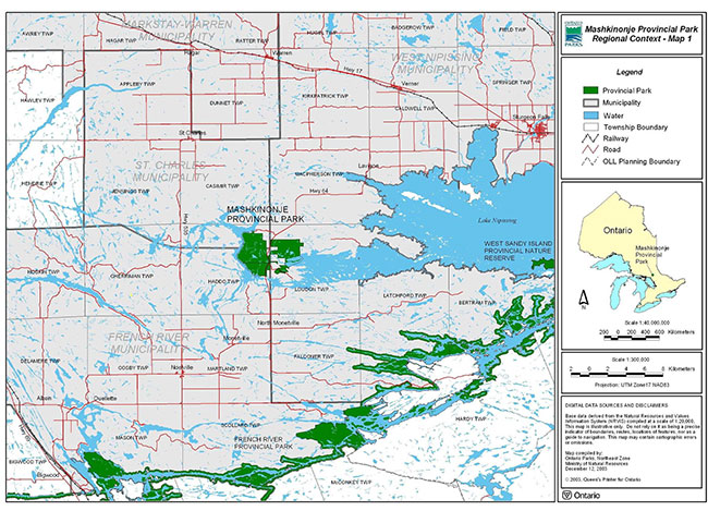
Enlarge Map 1: Mashkinonje Provincial Park Regional context
4.0 Objectives
As a natural environment class park, Mashkinonje contributes to the achievement of the four Ontario Provincial Park objectives: protection, heritage appreciation, tourism and recreation.
The objectives are described as follows:
4.1 Protection
To protect provincially significant features of Ontario that contribute to the representative natural landscape in the West Arm Area of Lake Nipissing in the North Bay Ecodistrict.
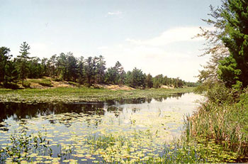
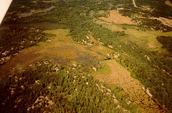
The park protects a representative sample of Ecodistrict 5E-5. Located near the northern edge of the Great Lakes-St. Lawrence forest, the park harbours white, red and jack pine, which grow on ridges blanketed with moss and lichen species. There are two provincially significant wetlands in the park. The Loudon Basin Peatland is a complex of four wetlands containing provincially, regionally and locally significant species. Several wetland communities occur in the Muskrat Creek wetland, which contain provincially, regionally and locally significant species. Orchids such as the pink lady slipper are often observed in the shelter of these mature upland forests. In the lowlands, a diverse representation of wetlands is displayed by swamps, marshes, fens, and sphagnum bogs. Notable wetland plant species identified include wild rice, large and small cranberry, pitcher plant, round leaved sundew, cotton grass, the locally uncommon dwarf birch and numerous wetland mosses.
Image of Muskrat Creek
4.2 Heritage appreciation
To provide opportunities for exploration and appreciation of the natural and cultural heritage of the park.
A Natural Heritage Education Plan will provide direction to achieve this objective (Section 8.2). The plan will stress the roles of wetland ecosystems and species within the park to assist in maintaining the parks' natural integrity and its surrounding landscape.
A park trail system will be planned to provide opportunities to interpret wetlands and historic features (i.e. historic cabin, sawmill site) (Sections 6.4, 8.4.2, 8.4.3 & 9.2). The park trail system may provide opportunities for the tourism industry, municipalities or other interests outside of the park (e.g. such as the development of a community based nature centre) (Section 9.6).
4.3 Tourism
To provide residents of Ontario and non-resident visitors with ecotourism-related experiences that complement the existing tourism industry in Sudbury East and West Nipissing.
Management of the park will aim to provide day-use opportunities. A park trail system (i.e. hiking, cross-country skiing) with interpretive opportunities may provide the existing tourism industry with an additional attraction (Sections 8.2, 8.5 & 8.6).
Access zones at the north and south end of the park (west of Highway 64) may provide local businesses/lodges with an opportunity to offer patrons additional recreational activities with associated heritage appreciation opportunities (Section 6.3 A5 & A6, Map 4).
4.4 Recreation
To provide recreation opportunities, with a primary focus on low-intensity day-use opportunities.
The primary focus for management will be low-intensity day-use opportunities of an educational and participatory nature. The park provides opportunities for activities such as hiking, snowshoeing, cross-country skiing, birdwatching, wildlife viewing, photography, canoeing, kayaking, boating, angling, hunting, swimming and nature appreciation (Sections 8.2 & 8.4).
Wildlife / bird viewing in the Loudon Basin Peatland
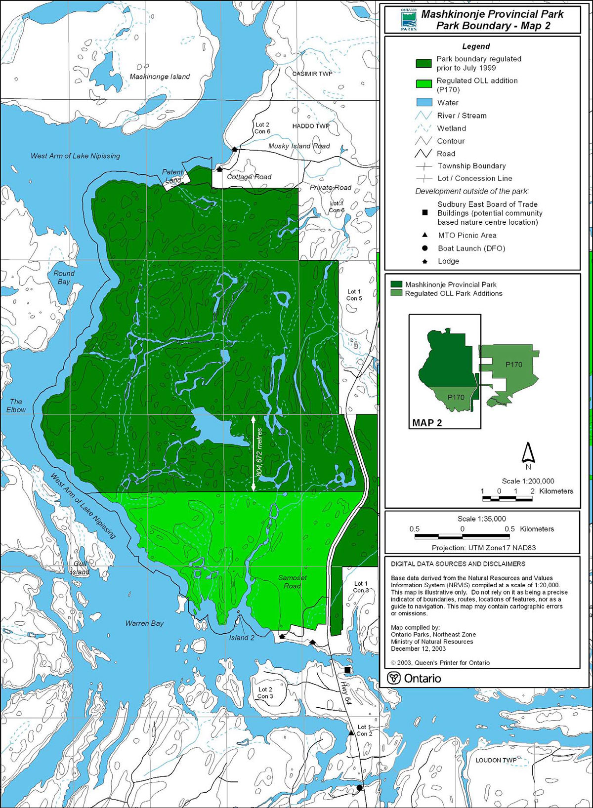
5.0 Park boundary (maps 2 & 3)
Mashkinonje Provincial Park was regulated in 1963 under the Provincial Parks Act (O. Reg. 117/63, Schedule 47). In 1970, Mashkinonje Provincial Park was regulated under Ontario Regulation 165/70, Schedule 47 with an area encompassing 1,242.4 hectares. Later in 1978, 302.69 hectares of the park were de-regulated (O. Reg. 517/78, Schedule 46) to allow for tourism development, thus leaving 939.71 hectares. In 2000, the Mashkinonje Addition (P170) identified in Ontario’s Living Legacy Land Use Strategy (1999) was regulated under Ontario Regulation 685/00 of the Provincial Parks Act. This addition encompasses an area of 1,101 hectares (which includes the 302.69 hectares that was previously de-regulated and undeveloped) bringing the total park area to 2,040.71 hectares.
Mashkinonje Provincial Park and the regulated Mashkinonje Addition (P170) will be regulated, in the future, under the Provincial Parks Act as one regulation (Section 10.1).
The park is located in the geographic Township of Loudon, Municipality of West Nipissing in the Territorial District of Nipissing and in the geographic Township of Haddo, Municipality of French River and St. Charles in the Territorial District of Sudbury.
West of Highway 64, the park is bounded by the West Arm of Lake Nipissing, Crown land and several private holdings including four tourism operations. East of Highway 64, the park is largely bounded by private parcels, Crown land and the West Bay of Lake Nipissing.
During the Invitation to Participate stage comments received indicate public interest in entering into agreements to protect values extending beyond the park’s boundaries. Conservation easements may be considered (Section 10.1).
Acquisition of property adjacent to the park will be considered on a case-by-case basis as opportunities become available (Section 10.1).
The park boundary may be signed to visually identify the park from adjacent lands (Section 10.1).
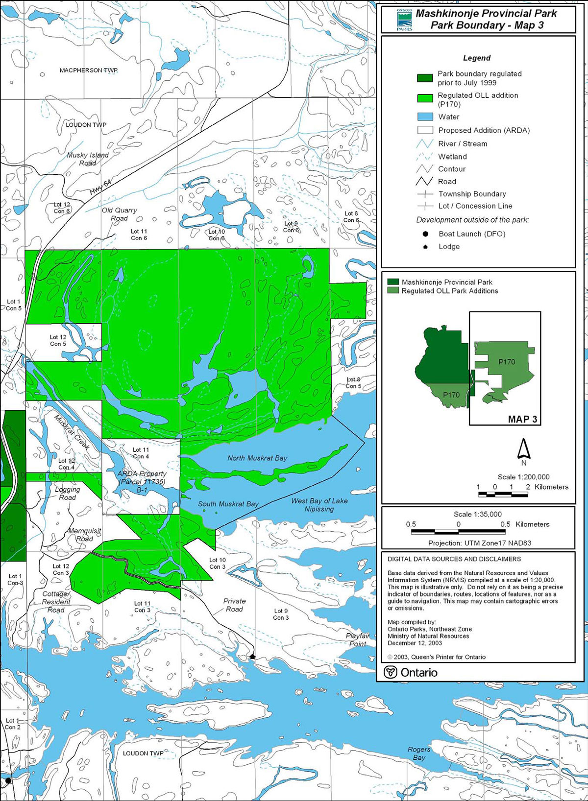
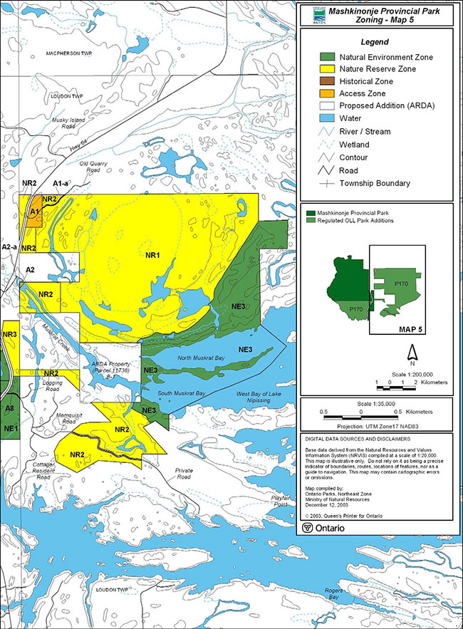
5.1 ARDA Lands (B1, maps 3 & 5)
In the early 1960s the Agricultural Rural Development Agreement (ARDA) was negotiated with the federal government. Under this agreement, the Province received substantial subsidies for land acquisition and park development.
A parcel of land (Parcel 11736) east of Highway 64 is presently held under the Agricultural Rural Development Agreement. This parcel (approximately 65 hectares) of Crown land will be considered as a future addition (B1) to the park and environmental assessment requirements will apply (Sections 10.1 & 10.2).
Forest communities within this parcel of land include red pine, white pine and jack pine with intolerant trembling aspen, jack pine and black spruce. Shallow soils and large bedrock outcrops also occur here. The diverse habitat types along Muskrat Creek support diverse waterfowl and fauna (Kershaw, M. & Hawes, K.J., 1999). This area is significant in the completion of the parks protection objective, as it contains a large portion of the provincially significant Muskrat Creek wetland (Maps 4 & 5).
The area would be regulated under the Provincial Parks Act as part of Mashkinonje Provincial Park and an amendment to this park management plan would be completed (Section 10.2). As per provincial park policy, nature reserve zoning is identfied for provincially significant wetlands and would be considered (Sections 6.1, 7.1.6, 7.2.1 & 10.2).
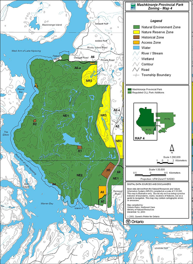
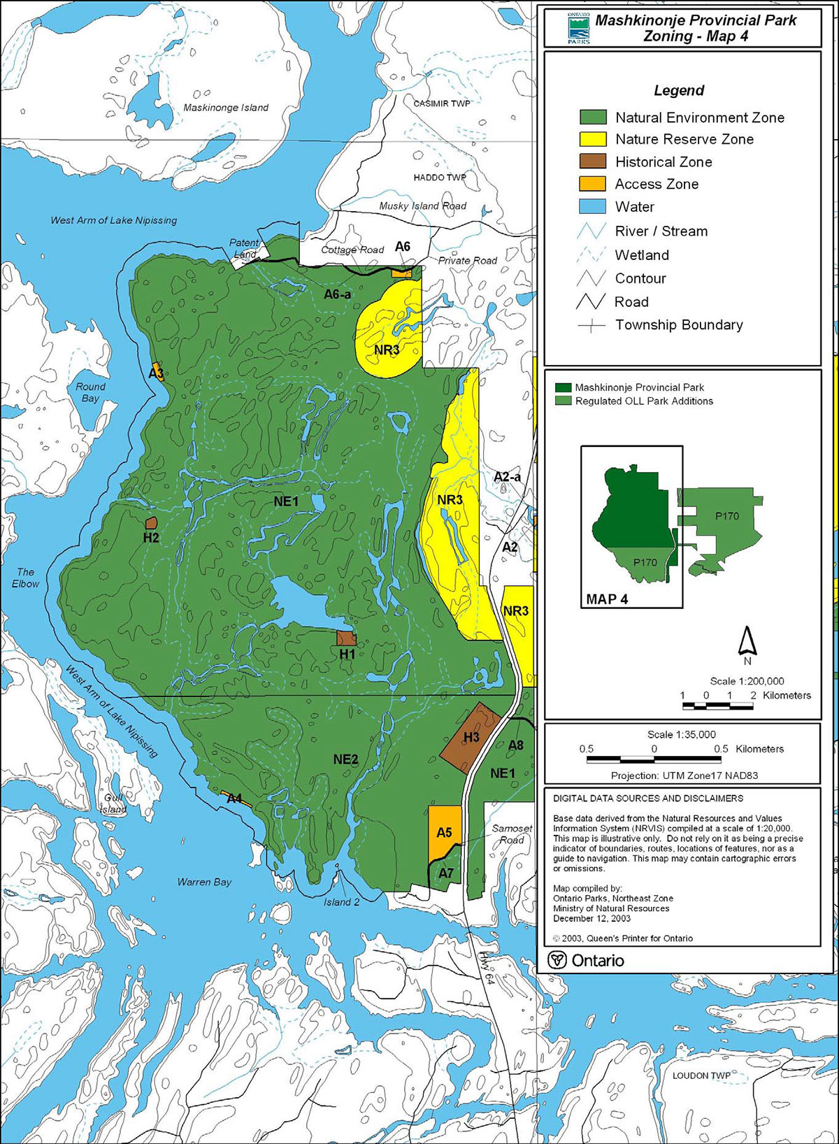
6.0 Zoning (maps 4 & 5)
Ontario provincial park policy identifies six possible land use zones for natural environment class parks: access, development, nature reserve, natural environment, historical and wilderness. Each zone permits certain land-uses and is managed in accordance with specific strategies. These zones will guide the management and development of the park. The zoning maps delineate zones, which are distinguished by their ecological protection and management needs, permitted levels of recreational use, and degree of access and development.
Resource management policies and recreation activities related to zones in a natural environment class park are identified in this park management plan and the Ontario Provincial Parks Planning and Management Policies (1992). Policies are also identified in Ontario’s Living Legacy Land Use Strategy (1999).
Four land use zones are identified to guide the management and development of the park: nature reserve, access, historical and natural environment.
6.1 Nature reserve zones (maps 4 & 5)
Nature reserve zones protect provincially significant natural features for their intrinsic value, their contributions to the environmental diversity of the park and park system, and their potential for scientific research and public appreciation. Significant features require management distinct from that of adjacent zones. The main priority for nature reserves is protection, with some types of research and uses being permitted. Only limited hiking, nature appreciation and non-destructive scientific research may be permitted. Site evaluations will be completed to prove that these activities will not disturb values represented within the zones.
Development will be very minimal and may include signs, trails and information aids, interpretive facilities and temporary research/management shelters based on the site’s ability to sustain these features with minimal detrimental effects (Section 9.0). Research applications and permits are required for scientific research (Section 8.3).
Three nature reserve zones have been identified to protect two provincially significant wetlands.
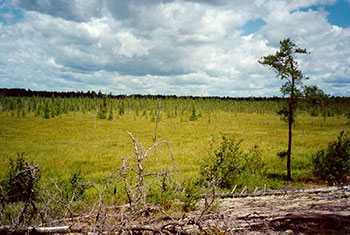
NR1 Loudon Basin Peatland (442 hectares)
NR1 represents a portion of the regulated Mashkinonje Addition (P170). The Old Quarry Road is not part of this zone (Sections 6.3 A1-a, 8.4.5 & 9.3).
This zone is a complex of four wetlands including a central core that has been declared a provincially significant wetland (OMNR, 1997). The Loudon Basin Peatland central basin is typical of a bog and fen that has developed in a circular depression. The entire feature is surrounded by a series of concentric bedrock rings of granite. Black spruce, larch, sphagnum moss and numerous low wetland shrubs dominate this circular ecological and geological feature (Kershaw, M. & Hawes, K.J., 1999).
Loundon Basin Peatland
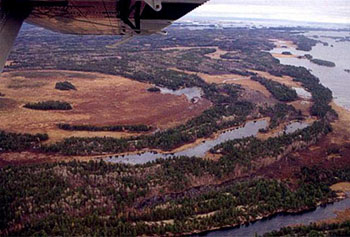
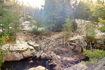
NR2 & NR3 Muskrat Creek (231.5 hectares)
NR2 represents a portion of the Muskrat Creek wetland within the regulated Mashkinonje Addition (P170) and NR3 represents a portion of the Muskrat Creek wetland within the park boundary regulated prior to July 1999. The west boundary of NR3, located on the west side of Highway 64 follows the treed edge. The portion of NR3, near A6, is defined by a 200 metre distance from the treed edge. The Old Quarry Road is not part of NR2 (Sections 6.3 A1-a, 8.4.5 & 9.3).
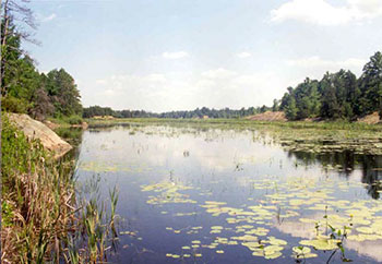
These zones consist of the area between the West Arm/Interior Wetland (NE1) and the Loudon Basin Peatland (NR1), south toward Memquisit Road. Approximately the first 200 metres of Memquisit Road is within the park and is identified as an access zone (Sections 6.3 A8, 8.4.5, 9.3 & Map 3). Memquisit Road, which disects a portion of NR2, is not within the park boundary (Sections 8.4.5, 9.3 & Map 3).
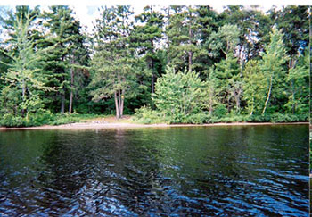
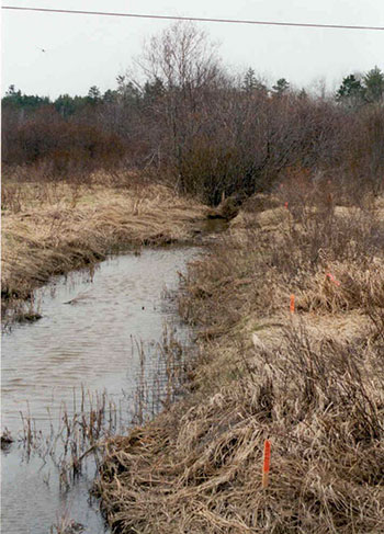
Muskrat Creek
Map 2: Mashkinonje Provincial Park, Park Boundary
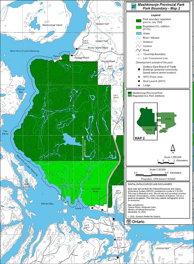
Enlarge Map 2: Mashkinonje Provincial Park, Park Boundary
Map 3: Mashkinonje Provincial Park, Park Boundary

Enlarge Map 3: Mashkinonje Provincial Park, Park Boundary
These nature reserve zones are comprised of an intricate wetland complex of marsh and swamp ecosystems separated by upland granite ridges. These zones represent a portion of a provincially significant wetland and contain a marsh environment, which provides suitable cover and habitat for fish spawning areas for northern pike, muskellunge and largemouth bass. It has long been an important fishery (i.e. pike and most notably muskellunge, northern pike and largemouth bass) for Lake Nipissing. Muskrat Creek attracts an abundance of waterfowl, which provides a staging area for migrating and breeding birds (Kershaw, M. & Hawes, K.J., 1999).
6.2 Natural environnent zones (Maps 4 & 5)
Natural environment zones include natural landscapes in which there is a minimum of development permitted to support low-intensity recreational activities. Development will be limited to portages, trails, signs necessary for route identification and minimal interpretative facilities which support low-intensity recreational uses (Sections 8.4 & 9.0). Camping opportunities may be considered in the future (Sections 8.4.12, 9.7, 10.1 & 10.2).
There are three natural environment zones identified for the park. NE1 represents a portion of the park regulated prior to July 1999. NE2 and NE3 represent portions of the regulated Mashkinonje Addition (P170).
NE1 West Arm / Interior Wetland (829.71 hectares)
This zone consists of a portion of park regulated prior to July 1999.
Dominant forest communities of jack pine and white pine with exposed bedrock outcrops can be found here. Open marshes, flooded thicket swamps, black spruce, white spruce, balsam fir, black ash, mountain maple, red pine, white birch and trembling aspen are also found in this zone (Kershaw, M. & Hawes, K.J., 1999).
The cottage road (A6-a) off Musky Island Road and Memquisit Road (A8) are not part of this zone (Sections 6.3, 8.4.5 & 9.3).
This zone also encompasses the shoreline/lakebed where the park boundary extends 91.44 metres (300 feet) into the West Arm of Lake Nipissing. Trails (i.e. hiking, cross-country skiing) are identified for this zone (Sections 8.4.2, 8.4.3 & 9.2). Activities such as hiking, cross-country skiing, snowshoeing, angling and boating are permitted.
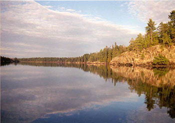
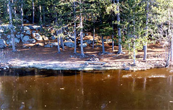
Shoreline along the West Arm of Lake Nipissing
NE2 Samoset Creek (260.5 hectares)
This zone consists of a portion of the area de-regulated in 1978, which is now a portion of the regulated Mashkinonje Addition (P170).
A diversity of forest communities, ecosites and the southern portion of Samoset Creek are located in this zone. There are active Great Blue Heron and Osprey nesting sites within this zone. The beaver activity in this zone controls the wetlands of Samoset Creek (Kershaw, M. & Hawes, K.J., 1999).
Samoset Creek
This zone is located in part of Concession 3 and 4 in Haddo Township (804.672 metres south of Concession 4/5 line) south to the shoreline of Warren Bay (Maps 2 & 4). It also encompasses the shoreline/lakebed where the park boundary extends 91.44 metres (300 feet) into the West Arm of Lake Nipissing (Warren Bay).
Low-intensity recreation activities such as hiking, canoeing/kayaking, boating, cross-country skiing, birdwatching and snowshoeing are permitted.
Samoset Road is not included in this zone (Sections 6.3 A7, 8.4.5 & 9.3).
NE3 West Bay (245 hectares)
This zone is located east of the Loudon Basin Peatland to the West Bay of Lake Nipissing, including the waters to the confluence of Muskrat Creek. There are fish spawning areas in this zone (Section 7.2.1). East of the peatland this zone contains trembling aspen, white birch and white spruce. The area closest to Lake Nipissing contains jack pine and white pine with shallow soils and exposed bedrock outcrops. Activities such as boating and hunting are permitted in this zone (Sections 7.1.6, 8.4, 8.4.5 & 8.4.7).
West Bay Zone is adjacent to the Loudon Basin Peatland
6.3 Access zones (maps 4 & 5)
Generally development in access zones is limited to roads, small parking areas, visitor control structures, appropriate signage, boat launch and basic day-use facilities. Camping opportunities may be considered in the future, however overnight mooring will not be permitted (Sections 8.4.5, 8.4.12 & 9.7).
There are eleven access zones, ten within the park. Six (A1, A2, A3, A4, A5, A6) provide access to the park, its trail system and natural heritage education opportunities. The Muskrat Creek Trailhead (A2-a) is located outside of the park boundary. In order to permit mechanized travel on the roads within the park, A1-a, A6-a, A7 and A8 have been identified as access zones (Sections 8.4.4, 8.4.5 & 9.3).
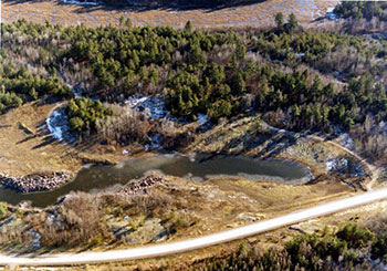
A1 Loudon Peatland Trailhead (7.5 hectares)
Located to the west of the peatland, this access zone includes a disturbed area formally used as a granite quarry. This trailhead will provide access to a trail into the provincially significant Loudon Basin Peatland (Sections 8.4.3, 9.1 & 9.2).
Trailhead area to access the Loudon Peatland Trail
A1-a Old Quarry Road (0.4 hectares)
This access zone includes an existing road (Old Quarry Road) which provides access to private property. This road does not provide access to the park, however it is identified as an access zone to allow the use of motorized vehicles to the private property (Sections 8.4.4, 8.4.5 & 9.3).
A2 Muskrat Creek Canoe / Kayak Access (0.3 hectares)
This zone is located in Muskrat Creek and provides water access to the park (NR2), where motorized vehicles (e.g. motorboats) are not permitted.
Map 4: Mashkinonje Provincial Park Zoning
Enlarge Map 4: Mashkinonje Provincial Park Zoning
Map 5: Mashkinonje Provincial Park Zoning
Enlarge Map 5: Mashkinonje Provincial Park Zoning
A2-a Muskrat Creek Trailhead
An old Ministry of Transportation (MTO) road bed is located outside of the park, east of Highway 64. Access to Muskrat Creek occurs at this location. This area may be considered for future development as a trailhead (e.g. parking, information display, etc) (Section 9.1).
Located east of Highway 64 is an old MTO road bed, which provides access to Muskrat Creek
A3 Pebble Beach (0.6 hectares)
The park boundary encompasses approximately two kilometres of the West Arm shoreline/lakebed of Lake Nipissing. This water access zone is located at the northwest end of the park and will provide access from the water to the park trail system (Sections 8.4.3, 9.1 & 9.2).
Water access to the park trail system
A4 Lapin’s Beach (0.4 hectares)
This zone consists of a portion of the de-regulated area in 1978, which is now a portion of the regulated Mashkinonje Addition (P170).
The park boundary encompasses approximately two kilometres of the West Arm shoreline/lakebed of Lake Nipissing. Located in a large bay with natural sand deposits this access zone is located at the southwest end of the park and will provide water access to the park trail system (Sections 8.4.3, 9.1 & 9.2).
Water access to the park trail system
A5 Blandings Access (8.8 hectares)
This zone consists of a portion of the de-regulated area in 1978, which is now a portion of the regulated Mashkinonje Addition (P170).
This zone is located west of the Highway 64 corridor and will be the main trailhead to the park trail system (Section 9.1).
Walk-in access will be provided to A5 from Samoset Road (A7). This may provide local businesses/ lodges with an opportunity to offer patrons additional recreational activities with associated heritage appreciation opportunities (Section 4.3). Vehicle parking is available at A5, therefore parking on or along Samoset Road is not permitted (Section 9.1).
A6 Martin Pond Access (0.7 hectares)
This access zone is located south of Musky Island Road. This zone will provide walk-in access to the park trail system (Section 4.3). A development strategy will be prepared to consider a trailhead (e.g. parking, information display) at this location (Sections 9.1 & 10.1).
A6-a Cottage Road (0.5 hectares)
This road (1 kilometre) is located off the Musky Island Road and provides access to cottages on private property. This road does not provide access to the park, however it is identified as an access zone to allow the use of motorized vehicles (Sections 8.4.5 & 9.3).
A7 Samoset Road (0.5 hectares)
This zone consists of a portion of the de-regulated area in 1978, which is now a portion of the regulated Mashkinonje Addition (P170).
This road (0.5 kilometres) provides access to a lodge on private property. This road does not provide access to the park, however it is identified as an access zone to allow the use of motorized vehicles (Sections 8.4.4, 8.4.5 & 9.3).
Walk-in access will be provided to A5 from Samoset Road. Vehicle parking is available at A5, therefore parking on or along Samoset Road is not permitted (Sections 6.3 A5 & 9.1).
A8 Memquisit Road (0.2 hectares)
This municipal road provides access to forest harvesting areas, a private road to a lodge and access to residences/cottages. Approximately the first 200 metres (0.2 kilometres) of Memquisit Road is within the park and does not provide access to the park, however it is identified as an access zone to allow the use of motorized vehicles (Sections 8.4.5 & 9.3).
6.4 Historical zones (map 4)
Historical zones encompass significant cultural resources of the park (Section 7.3). They generally focus on a specific site (e.g. building) and its relationship to the surrounding landscape. Development will be limited to trails, signs, interpretive, educational, research and management facilities (Sections 8.3 & 9.0).
There are three historical zones within the park.
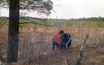
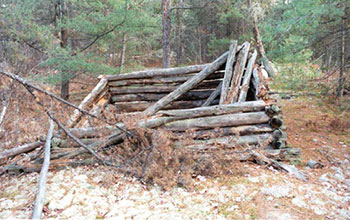
H1 Historic Cabin (0.5 hectares)
This zone provides protection of a historical value. This structure is related to the military history of the area.
Remnants of a historic cabin within the park
H2 Sawmill Site (0.6 hectares)
This zone provides an interpretive opportunity to view the remnants of a sawmill site that was in operation during the 1950s and 1960s, when horses were used. Although the buildings are no longer standing, evidence of the operation is still visible along the park trail system.
Some evidence of the sawmill operation
H3 Village Site (11.0 hectares)
This zone provides protection of a potential Nipissing village site. The result of a stage two archaeological assessment indicates that this may have been a small village site (Slattery, 2003). Due to the shallow depth to bedrock and the substantial tree roots, it is unlikely that any structures will be found (Slattery, 2003).
7.0 Resource stewardship policies
The park will be managed as a natural environment class park. The park will be managed according to the planning and management policies identified in Ontario Provincial Parks - Planning and Management Policies (1992), Ontario’s Living Legacy Land Use Strategy (1999), the Environmental Assessment Act, the approved park management plan, and minimum operating standards. An Operating Plan required for park infrastructure will reflect provincial operating standards and will be kept current to implement and guide specific operational aspects of managing the park (Section 8.0).
The Crown Land Use Policy Atlas is the consolidation of existing local land use policies for Crown lands in a large part of Ontario, including the Ontario’s Living Legacy planning area. An amendment to the policy reports for Mashkinonje Provincial Park and the Mashkinonje Addition in the Crown Land Use Policy Atlas will be completed and updated as necessary to reflect the direction of the park management plan (Section 10.1).
Although the policies herein are presented in separate categories, planning and management recognizes that the components are interrelated and that operations, management and protection will ensure that overall park objectives are achieved.
7.1 Terrestrial ecosystems
The management of land will be directed toward sustaining natural ecological processes on the landscape.
7.1.1 Earth science
Bedrock in the park consists of granitic gneiss of the Grenville geologic province. The gneiss developed between 2.5 to 1 billion years ago during a long period of mountain building. A very distinctive oval pattern in the Loudon Peatland reflects the forces active at that time.
Glacial and glaciolacustrine deposits occur in small patches in the park and reflect the retreat of glacial ice, and the flooding of the area by post glacial lakes.
7.1.2 Shoreline management
The park is part of the Lake Nipissing-French River system, which lies within the Georgian Bay and Lake Huron drainage basin. Seasonal fluctuations in the water level occur and are managed by the Sturgeon-Nipissing-French Water Management Advisory Board (Sturgeon River/Lake Nipissing/French River Water Management Plan, 1992). Public Works and Government Services of Canada currently manage the water levels of Lake Nipissing and the flow of the French River (Lake Nipissing/ French River Operational Guidelines, 1995) (Section 7.2).
7.1.3 Adjacent land management
The Park Superintendent will work with forest management interests, the Ministry of Northern Development and Mines, MNR, and other agencies to minimize, control and mitigate the impact of adjacent land uses (e.g. forest operations, mineral exploration, agricultural activities) on the park environment (e.g. natural processes, hiking trails, viewsheds and aesthetic value) and park visitor experiences (Section 10.1).
Forest operations
The park is located within the Nipissing Forest and the Sudbury Forest. Forest management for the surrounding area, is governed by the Nipissing Forest Management Plan and the Sudbury Forest Management Plan. The Park Superintendent will work with MNR District staff and the forest companies to ensure that park values are considered during forest management planning (Section 10.1).
Forest operations, identified in the Nipissing Forest Management Plan, are scheduled to the northeast of the park and adjacent to the park boundary on the southern edge of the regulated Mashkinonje Addition (P170).
There are no forest operations scheduled adjacent to the park, which are identified in the Sudbury Forest Management Plan.
Hydrology/agricultural drainage
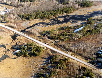
High beaver activity and the low-relief of the park influence the primary watersheds within the park where the water levels of the contiguous system of interior wetlands change annually (Kershaw, M. & Hawes, K.J., 1999). During high water levels, beaver activity in the park may result in the flooding of roads within/adjacent to the park. The Park Superintendent will work with municipalities and MTO to minimize, control and mitigate the impact of flooding on roads within/adjacent to the park (Section 10.1). All work within the park will be subject to environmental assessment requirements.
East of Highway 64, drainage from agricultural ditches and fields north of the park currently flow away from the Loudon Peatland and have minimal impact on the Loudon Basin. The drainage also currently flows southeast into West Bay or southwest into the Bay through Muskrat Creek.
Agricultural drainage adjacent to Musky Island Road
West of Highway 64 drainage currently flows east through the West Arm of Lake Nipissing into the West Bay (Kershaw, M. & Hawes, K.J., 1999).
The Park Superintendent will work with adjacent land owners, municipalities and the Ministry of Agriculture, Food and Rural Affairs to minimize, control and mitigate the impact of drainage on the watersheds, which flow into the park (Section 10.1). Drainage will be monitored to ensure the protection of the parks' environment (Section 10.1).
Mineral exploration
There are no mining lands (i.e. mining claims, leases, licenses of occupation and patents) within the park, therefore mineral exploration and mining are not permitted in the park or park addition (P170).
There are freehold patents adjacent to the park.
Commercial mineral exploration and extraction, sand and gravel extraction, and peat development will not be permitted within Mashkinonje Provincial Park or the regulated Mashkinonje Addition (P170).
7.1.4 Patent property and Land Use Permits
There are no Land Use Permits within the park. Disposition proposals will be considered on a case-by-case basis and meet environmental assessment requirements. No land disposition for the private use of individuals or corporations will be permitted.
There is one patent property (Island 2, PCL 12963 – Warren Bay) surrounded by the park at the south end in Haddo Township and is not part of the park (Map 2).
There are four patent properties (Pcl. 23146, Pcl. 14636, Pcl. 18705 & Pcl. 14635) at the north end of the park in Haddo Township, which are accessed via A6-a or by water and are not part of the park.
There are several patent properties adjacent to the park.
7.1.5 Vegetation management
The management of vegetation will be directed toward promoting a healthy and natural diversity of vegetation in the park. A Vegetation Stewardship Plan will be prepared for the park, by Ontario Parks or in consultation with Ontario Parks (Section 10.1). The plan will identify approaches to continue plant inventories and future monitoring. Should provincially significant plants or species at risk be identified in future studies, the Vegetation Stewardship Plan will address protection needs (Section 10.1).
Commercial forest operations are not permitted within the park.
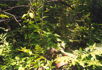
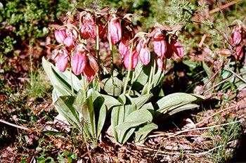
Pink Lady’s Slipper
Vegetation control
Trees may be removed from access, historical or natural environment zones to facilitate capital construction or for resource management purposes. Environmental assessment requirements must be met. Trees will also be removed where there is a threat to public safety or property. Vegetation restoration, monitoring and inventories will be considered as part of the Vegetation Stewardship Plan (Section 10.1).
Vegetation control will be permitted where necessary along public utilities and rights-of-way and must meet environmental assessment requirements. The Park Superintendent will work with MTO to minimize, control and mitigate the impact of spraying chemical herbicides along the Highway 64 corridor, within the park (Section 10.1). Alternative tending methods (e.g. hand tending) may be used. The Park Superintendent will work with the Municipalities to minimize, control and mitigate the impact of any road maintenance (e.g. tending, spraying, etc.) may have on the park (Sections 9.3 & 10.1).
Harvesting
Commercial harvesting of trees, wild rice, cranberry, peat and sphagnum moss does not occur within the park. New operations will not be permitted.
Non-native plants
Non-native plant species will not be deliberately introduced into the park. Where non-native plant species are already established, and threaten park values, a strategy will be developed as part of the Vegetation Stewardship Plan to control the species (Section 10.1). Educational and appropriate management programs will be implemented to inform visitors of species found in other parts of Ontario that may threaten park values if introduced. Exotic flora (e.g. Purple Loosestrife) will be managed in accordance with established management practices.
Insects and disease
Insect infestations and diseases, native to the forest region in which the park is situated, are integral components of the park`s ecology. In nature reserve zones, they will be allowed to progress naturally unless values are threatened, whereby outbreaks may be controlled. Where feasible, non-native insects and diseases will be controlled to minimize effects on the balance of the park environment. Biological controls will be used whenever possible. Where the use of biological controls is not possible, the Ministry of the Environment will be contacted. Control of insects and disease is subject to environmental assessment requirements.
Forest fire management
All forest fires within the park will be suppressed in accordance with the park management plan, the Fire Management Strategy for Ontario and the Great Lakes/St. Lawrence Zone designation identified in that strategy. Any fire management work will be carried out only under the guidance of a Fire Management Plan. In consultation with the MNR-Forest Fire Management Section a Fire Management Plan will be prepared, by Ontario Parks, or in consultation with Ontario Parks for the park (Section 10.1). The plan will identify management and protection priorities relating to the use of fire, fire prevention, and suppression activities in the park. In the absence of a specific fire management plan for the park, fire management will be carried out as on adjacent public lands in accordance with the Forest Fire Management Strategy for Ontario.
Protection from fire will be provided in all cases where life and property are threatened.
Prescribed burning
As per provincial park policy, where necessary, prescribed burning may only occur in nature reserve and historical zones. Prescribed burning will be addressed in the Fire Management Plan and occur only in accordance with an approved prescribed burn plan, which will be developed in consultation with the MNR-Forest Fire Management Section (Section 10.1).
Utility corridors
There are no utility corridors within the park. All public utilities (e.g. pipelines, transmission lines, communications towers, waterlines, etc.) must avoid park lands wherever possible.
Any future utility corridors proposed through the park, where park lands are unavoidable, will be reviewed on a case-by-case basis. Protection of park values will be a priority and MNRs environmental assessment requirements must be met.
7.1.6 Wildlife management
There are four known provincially significant animal species in the park. In each case, they are located beyond their previously reported northern range limit (Kershaw, M. & Hawes, K.J., 1999).
A Wildlife Stewardship Plan will be prepared to address the management of wildlife in the park, which will be directed toward promoting healthy and diverse populations and follow environmental assessment requirements (Section 10.1). The plan will address the management of provincially significant species, species at risk, inventories and species monitoring (Section 10.1).
Wildlife viewing and birding will be encouraged. These activities are enhanced by the park trail system. Protection of wildlife (e.g. nesting areas, etc) will be considered when developing the park trail system (Sections 8.4.3 & 9.2).
Non-native species will not be deliberately introduced into the park. Missing native species may be re-introduced and existing populations replenished, if biologically feasible and acceptable and environmental assessment requirements are met. The removal of wildlife for stocking programs is not permitted.
Animal populations may be controlled when essential to protect human health and safety, the health of the species outside the park, or the values for which the park was established. When control is desirable, techniques with minimal effects on the balance of the park’s resources will be used. Select controls of animal populations will be implemented under the strict supervision of the Park Superintendent, or directly by, the Ontario Ministry of Natural Resources District Office. Such control will only be directed at populations requiring attention.
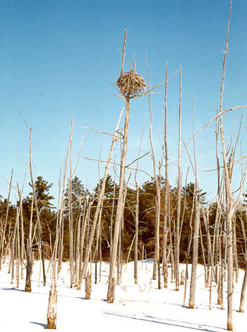
Great Blue Heron rookery
Rabid animals or rabies will be subject to Environmental Assessment Act Exemption Order MNR-62 (Wildlife Rabies Control Program).
Vulnerable, threatened & endangered species (Species at Risk)
There are species at risk within the park. Further studies/inventories will be completed to identify the number of species at risk within the park (Sections 8.3 & 10.1). Information gathered on species at risk will assist in the development of management practices.
Trapping
There are portions of three currently licensed traplines in the park. One is within the MNR Sudbury District (SU77) and two are within the MNR North Bay District (NB41, NB50).
There are no trap cabins located within the park and new cabins will not be considered.
As per Ontario’s Living Legacy Land Use Strategy (1999), existing commercial fur harvesting (SU77) will continue in the park area regulated prior to July 1999 (O. Reg. 821/80, Schedule 46), except in nature reserve zones (NR3) where these activities will be phased out by January 1, 2010 (Sections 6.1, 10.1, Maps 4 & 5).
Existing commercial fur harvesting (SU77, NB41 & NB50) will be permitted to continue in the regulated Mashkinonje Addition (P170) (Maps 2 & 3).
The transfer of authorized traplines may be permitted. Transfers of active licenses, permits or other types of authorization would be permitted, subject to a review of potential impacts, and the normal types of transfer or renewal conditions that would apply within a protected area.
In order for authorized commercial fur harvesters' to access their traplines within the park, an access agreement may be established between Ontario Parks and the trapper to minimize, control and mitigate the impact of motorized vehicles on park values (Section 10.1).
ARDA lands
The ARDA lands are part of the provincially significant Muskrat Creek Wetland. These lands will be considered as a future addition to the park and nature reserve zoning is recommended (Section 5.1, Map 3). As per existing policy, commercial fur harvesting would be permitted to continue should this area be added to the park.
First Nations/aboriginal peoples
Status Indians exercising treaty rights are permitted to continue commercial fur harvesting in the park, subject to applicable legislation and regulations.
The transfer of traplines is permitted between Status Indians. Only Status Indian trappers' helpers are permitted to assist Status Indian trappers.
Hunting
Hunting is not permitted within the park boundary regulated prior to July 1999 (O. Reg 821/80, Schedule 46) (Maps 2 & 3). The following zones are within this section of the park: NE1, NR3, H1, H2, A3, A6, A6-a and A8 (Sections 6.1-6.4, Maps 4 & 5).
Hunting is not permitted within the following zones of the Mashkinonje Addition (P170): NE2, H3, A1, A1-a, A2, A4, A5, A7, NR1 and NR2 (Sections 6.1- 6.4, Maps 4 & 5). As per provincial park policy, provincially significant earth/life science features are protected by nature reserve zones (Ontario Provincial Parks - Planning and Management Policies, 1992). The Loundon Basin Peatland (NR1) and portions of the Muskrat Creek Wetland (NR2) are considered provincially significant wetlands and are within the regulated Mashkinonje Addition (P170) (Maps 2 & 3). Since these wetlands are identified as nature reserve zones, hunting is not permitted (Ontario’s Living Legacy Land Use Strategy, 1999) (Section 6.1, Maps 4 & 5). Hunting activities within the regulated Mashkinonje Addition (P170) within Haddo Township (NE2) will not be permitted (Map 2). This will protect the natural integrity of the park, provide year-round low-intensity recreational opportunities (e.g. hiking, nature appreciation) and consider the safety of park visitors and the adjacent lodges (Section 6.2, Map 4).
Hunting will be permitted in the natural environment zone identified as NE3 (Section 6.2, Map 5). Provincial park policy permits hunting within natural environment zones. Previous consultation identified that the mouth of Muskrat Creek (Muskrat Bay) is a popular hunting location. In the past, several blinds for hunting have been placed at the mouth of the creek and are used annually by local hunting guides, tourists and residents.
Hunting is permitted in the regulated Mashkinonje Addition (P170) as per O. Reg. 687/00, s.4, Schedule 73 under the Fish & Wildlife Conservation Act, however this regulation will be amended to reflect park zoning as mentioned above (Sections 6.1- NR1 & NR2; 6.2 - NE2; 10.1; Maps 2, 3, 4 & 5).
Hunting within the park is subject to provincial and federal (Fish & Wildlife Conservation Act, Endangered Spedies Act, and the Migratory Birds Convention Act) hunting regulations (refer to the Ontario Hunting Regulations Summary for more information).
ARDA lands
The ARDA lands are part of the provincially significant Muskrat Creek Wetland. These lands will be considered as a future addition to the park and nature reserve zoning is recommended. Hunting is not permitted in nature reserve zones (Section 5.1, Maps 3 & 5).
Bear Management Areas
There are portions of two existing bear management areas (BMA) in the park. These two BMAs are administered by the MNR Sudbury District (Haddo Township, SU42-004 & SU42-017). There are no existing BMAs in Loudon Township, MNR North Bay District.
Hunting is not permitted within the park boundary regulated prior to July 1999 (O. Reg 821/80, Schedule 46). The Park Superintendent will work with the MNR Sudbury District to have the BMA descriptions amended to exclude the park area regulated prior to July 1999. BMA descriptions within Haddo Township (NE2) will also be amended accordingly (Sections 6.2, 10.1 & Maps 2, 3 & 4).
Existing BMA licences will not be renewed or transferred within Haddo Township (NE2).
New BMA licences will not be issued.
7.2 Aquatic ecosystems
There are no water control structures within the park. New water control structures will not be permitted within the park.
There are three dams on the Upper French River outlets from Lake Nipissing that manage the water level of Lake Nipissing and the flow of the French River (Lake Nipissing /French River Operational Guidelines, 1995).
The fluctuation of water levels may affect the park. The Park Superintendent will work with the Sturgeon – Nipissing – French Water Management Advisory Board and the Public Works and Government Services Canada to minimize, control and mitigate the impact of fluctuating water levels on the park (Sections 7.1.2 & 10.1).
The protection of wetland ecosystems will be considered as the park trail system is planned and developed (Sections 8.4.1, 8.4.2, 8.4.3, 9.1 & 9.2).
7.2.1 Fisheries management
Fisheries management (e.g. spawning areas, habitat protection, stocking, etc.) within the park and Lake Nipissing adjacent to the park (i.e. West Arm and West Bay) will comply with the existing Lake Nipissing Fisheries Management Plan and environmental assessment requirements.
Fisheries management activities will maintain and enhance native, self-sustaining fish populations.
Designated park waterbodies, with appropriate consultation, may be closed to fishing temporarily or permanently for research or management purposes.
Sport fishing
Sport fishing is permitted and is subject to provincial and federal fisheries regulations (e.g. Fisheries Act, Fish and Wildlife Conservation Act). The park is located in Division 27 and 15 according to the Fisheries Act and Ontario Recreational Fishing Regulations Summary.
Sanctuaries
Lake Nipissing, east of Highway 64 is within a fish sanctuary (Division 27) established under the Fisheries Act. Details relating to the sanctuary can be found in the Fisheries Act and Ontario Recreational Fishing Regulations Summary.
Fish stocking
The activity of stocking native fish species within the park may occur in natural environment zones and must meet environmental assessment requirements. Any stocking activity will be in accordance with the Lake Nipissing Fisheries Management Plan prepared by the Ministry of Natural Resources North Bay District Office. The MNR District must consult with Ontario Parks prior to any fish stocking that may occur within the park boundary.
Non-native fish introductions
Non-native fish species will not be deliberately introduced.
Bait fish
Provincial park policy for natural environment class parks states that the use or possession of bait fish is prohibited within the park (refer to Ontario Recreational Fishing Regulations Summary for definition of bait fish).
In order to comply with provincial park policy and reduce the risk of accidental introductions, regulations, under the appropriate legislation, will be established to prohibit the use or possession of live bait within waterbodies wholly contained within the park (Section 10.1).
The use or possession of bait fish in waterbodies (i.e. Lake Nipissing) not wholly contained within the park will be permitted.
Commercial fishing
Commercial fishing does not occur within the park, however does occur on Lake Nipissing.
Commercial bait fishing
There are portions of two licensed commercial bait fishing operations in the park. One is within the MNR Sudbury District (SUD 0004, Haddo Township) and one is within MNR North Bay District (NB-RH-123-02, Loudon Township).
Licensed commercial bait fishing operations within the park area regulated prior to July 1999 will be permitted to continue, except in nature reserve zones (NR3), where these activities will be phased out by January 1, 2010 (Sections 6.1 & 10.1, Map 4). The Park Superintendent will work with the MNR District to have the bait harvest area amended to exclude the nature reserve zone (Section 6.1- NR3).
Licensed commercial bait fishing operations within the regulated Mashkinonje Addition (P170) will be permitted to continue (Maps 2 & 3).
Existing licenses may be transferred where commercial bait fishing is an established permitted use.
In order for authorized commercial bait fishing operators to access their harvest areas within the park, an access agreement may be established between Ontario Parks and the operator to minimize, control and mitigate the impact of motorized vehicles on park values (Section 10.1).
ARDA Lands
The ARDA lands are part of the provincially significant Muskrat Creek Wetland. These lands will be considered as a future addition to the park and nature reserve zoning is recommended. As per existing policy, should these lands be regulated as part of the park, commercial bait fishing would be permitted to continue (Section 5.1, Maps 3 & 5).
7.3 Cultural resources management
The management of cultural resources within the park will be directed at protection and heritage appreciation (Section 6.4). Cultural heritage sites will be protected and any use of these sites that is incompatible with cultural values will be prohibited. Archaeological and historical artifacts may be removed through approved research projects for the purpose of defining past cultural activities in the park and surrounding area (Section 8.3).
The archaeological significance of the park is not known. Archaeological and historical research consistent with provincial park policy is encouraged (Section 8.3). Prior to any development which would alter undisturbed lands or shoreline an archaeological assessment will be completed (Section 10.2).
Environmental assessment requirements will apply to any maintenance, restoration or reconstruction of historical, archaeological or cultural resource.
8.0 Operations policies
Presently, the park is non-operating. Operation, including development, of Mashkinonje Provincial Park may be subject to the establishment of a formal partnership agreement with Ontario Parks. A Business Plan for the park will be prepared by Ontario Parks or in consultation with Ontario Parks (Section 10.1).
The park will be managed according to the planning and management policies defined in the Ontario Provincial Parks - Planning and Management Policies (1992), Ontario’s Living Legacy Land Use Strategy (1999), environmental assessment requirements, the approved park management plan, and minimum operating standards.
A Park Operating Plan will be prepared to provide staff with the necessary operational information required to carry out day-to-day operations (Section 10.1). The Park Operating Plan will also address budget, staffing, maintenance, enforcement, and emergency services. The Park Operating Plan will be consistent with the approved Ontario Provincial Parks Operating Standards and will be approved annually and updated as required.
8.1 Partnerships
A formal partnership agreement may be established between Ontario Parks and a third party to assist in the management, development and operations of the park (Section 10.1). The partner will represent the local communities, and local and provincial interests. The partner will work with Ontario Parks to implement the approved park management plan and follow provincial park policies and regulations.
Should a formal partnership agreement be established it will define the roles and responsibilities of each partner, including Ontario Parks. An outline of each partners involvement, including Ontario Parks, for the implementation of the park management plan as well as on-going park operations will be included.
8.1.1 Friends of Mashkinonje
The "Friends of Mashkinonje" a charitable co-operating association was established.
The general objectives of such a co-operating association will be worked out with Ontario Parks in a formal agreement that may include:
- supporting and enhancing the park’s interpretive, recreational and resource protection activities
- encouraging greater awareness and appreciation of the park
- developing, supporting and delivering programs which relate directly to their objectives
- selling Ontario Parks merchandise, a variety of park-specific educational materials and appropriate souvenir items; and
- soliciting and accepting donations, bequests and other gifts which further their objectives
Activities associated with Friends' groups, as identified in a formal agreement with Ontario Parks, might include:
- publishing interpretive materials and guides
- supporting research programs
- upgrading interpretive trails
- sponsoring special events; and
- fund raising for projects
8.2 Natural heritage education
Natural heritage education will be managed in accordance with the approved park management plan and provincial park operational policies and procedures. A Natural Heritage Education Plan will be prepared by Ontario Parks or in consultation with Ontario Parks (Section 10.1). Approval of the plan will rest with Ontario Parks. The primary purpose of natural heritage education will be to inform park visitors about the interpretive, educational and recreational activities and services in the park and surrounding area. The plan will stress the roles of wetland ecosystems and species within the park to assist in maintaining the park’s natural integrity and its surrounding landscape (Section 4.2).
Approaches such as, publications, display panels and self-guided trails will be the main methods used. Direction for natural heritage education will be taken from provincial park policies (PM 6.02). The park trail system may provide the existing tourism industry with an additional attraction (Sections 4.3, 8.4.2, 8.4.3 & 9.2).
Interpretation
A Natural Heritage Education Plan will outline education management guidelines for the benefit of park users. Visitors will gain an understanding of, awareness of, and appreciation for natural and cultural heritage values, and park’s policies and management objectives. Interpretation will focus primarily on the significant ecological communities within and surrounding the park.
Most services for park visitors including tourists, local residents and school groups will be self-use. Self-use interpretive materials (e.g. pamphlets, special publications, maps, etc.) may be availble at key access points, partner locations and the Friends of Mashkinonje. Additional interpretive material may be provided at a community based nature centre (Section 9.6).
Information
Information about park resources, management facilities and programs, and nearby points of interest will be made available at designated trailheads and at various businesses in the surrounding area.
Self-use information materials and facilities may include a park brochure, signage, plaques, pamphlets, special publications, maps and information sheets. Kiosks at access points (e.g. A1, A5) may be constructed to integrate park information, resource interpretation and management messages (Section 10.1).
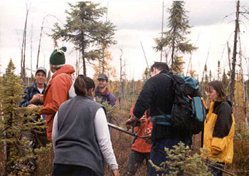
Educational institutes use the park as an education opportunity - Loudin Basin Peatland
Recreation
Recreation trails and infrastructure will provide park visitors with recreation opportunities and facilities to access the park. Where required, approaches and appreciation of park values will be developed to improve visitor skills to ensure safe use and to maximum enjoyment of the park. The park trail plan will identify the main recreation infrastructure.
8.3 Research
Scientific research, by qualified individuals, which contributes to the knowledge of natural and cultural history and to environmental and recreational management, will be encouraged in the park (Section 7.3). Ontario Parks will encourage institutions to undertake research projects. All research will require the approval from Ontario Parks and will be subject to park policy and other applicable legislation. Ontario Parks may allow research/collection of any natural or cultural specimens by qualified researchers. All such materials removed remain the property of Ontario Parks.
Approved research activities and facilities will be compatible with the park objectives. Any research of the parks natural or cultural features will be as unobtrusive as possible. If a site is disturbed by research it will be rehabilitated as closely as possible to its original state. Environmental assessment requirements will apply.
A comprehensive Natural Science Inventory (Kershaw, M. & Hawes, K.J., 1999) was completed during the fall of 1999. The inventory supplied park management planners with the necessary information to formulate management planning decisions. Additional scientific research in the park by qualified individuals will be encouraged (e.g. earth science surveys, archaeological, cultural/historical, species at risk, etc.) (Sections 7.1.5, 7.1.6, 7.3 & 10.1).
Research must contribute to the knowledge of natural and cultural history, and to environmental and recreational management. It must be non-consumptive in order to safeguard protection objectives.
8.4 Recreation management
The park provides outstanding opportunities for a variety of recreational uses compatible with the natural character of the park. Year-round day-use activities will be based on interaction with the natural environment and appreciation of natural and cultural values of the park.
Recreation management will be directed toward low-intensity recreational opportunities such as organized and/or self-guided interpretive hiking trails, platforms for birdwatching and wildlife viewing, and boardwalks. Winter activities include cross-country skiing and snowshoeing. A trail plan will be developed and will include direction for trail development (i.e. hiking & cross country skiing) and signage of the park trail system (Section 9.2 & 10.1). Site plans must be developed and approved and environmental assessment requirements must be met prior to any development.
8.4.1 Parking and trailheads
Parking areas and trailheads will be developed within access zones to provide access to the park trail system (Sections 6.3 A1, A5, A6 & 9.1).
8.4.2 Cross-Country Skiing / Snowshoeing
Snowshoeing and cross-country skiing are permitted within the park.
Cross-country ski trails and a small 'warm-up' facility may be developed in the park (Sections 9.2 & 10.1). Trails within the park will not be groomed unless a partnership agreement is established to groom and maintain the trails (Sections 9.2 & 10.1). Grooming trails (e.g. snowmachine) is subject to the protection of park values (Section 8.4.5). Trail grooming will be keeping with the goal of providing low-intensity recreation opportunities (i.e. classic ski trail).
Snowshoeing in the park
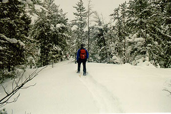
8.4.3 Hiking (map 6)
Hiking opportunities will be provided in the park. Trails, bridges, boardwalks and lookout locations will be subject to approved site planning and environmental assessment requirements (Sections 9.1 & 9.2). Some preliminary work has been completed for the park trail system, however site planning will determine specific trail locations and supporting infrastructure. These trails will be accessible from the designated access zones (Sections 6.3 & 9.2, Maps 4 & 5).
Coastal trail
The Coastal Trail will be located on the west side of Highway 64 and will connect with other trails creating a circular trail near the perimeter of the park (Haddo Twp) (Section 9.2). There is potential to develop this into a cross-country ski trail. This trail will include several forest and wetland communities and sandy beaches. There are education and interpretation opportunities such as, wildlife viewing areas and geological and historical points of interest.
Atakas trail
The Atakas (cranberry) Trail weaves through the centre of the park (Haddo Twp) providing users with an opportunity to view the various wetland and forest communities, as well as the historical zones (Section 9.2). There is potential to develop this into a cross-country ski trail. Wetland protection will be considered during site planning.
One of many hiking opportunities in the park
Samoset Creek trail
Located west of Highway 64 near the southeast end of the park there will be a short loop trail, off the Coastal Trail (Sections 9.1 & 9.2). This trail includes jack pine ridges and passes small wetland areas with wildlife viewing and bird watching opportunities. There is potential to develop this into a cross-country ski trail.
Martin Pond trail
Located west of Highway 64 near the northeast end of the park there will be a short loop trail (Sections 9.1 & 9.2). This trail includes granite upland ridges, a wetland complex of marsh and swamp ecosystems and will provide wildlife and bird watching opportunities. There is potential to develop a portion (section of Coastal Trail) of this into a cross-country ski trail.
Pebble Beach trail
Located west of Highway 64 near the northwest end of the park this trail traverses bedrock ridges and winds through jack pine, trembling aspen, red maple and red oak. Maskinonge Island can be seen from this trail. This trail will connect to the Coastal Trail (Sections 9.1 & 9.2). There is potential to develop a portion (section of Coastal Trail) of this into a cross-country ski trail.
Lapin’s Beach trail
Located west of Highway 64 near the southwest end of the park this trail provides a view of a black ash swamp and sandy beach. Sweet gale, winter holy, speckeld alder and poison ivy can also be see along the trail. This trail will connect to the Coastal Trail (Sections 9.1 & 9.2). There is potential to develop a portion (section of Coastal Trail) of this into a cross-country ski trail.
Heron trail
Located west of Highway 64 along the east side of Haddo Township this trail will follow rock ridges. Bog species, beaver activity and bird watching are a few points of interest along this trail. This trail is part of the Coastal Trail (Sections 9.1 & 9.3). There is potential to develop a portion (section of Coastal Trail) of this into a cross-country ski trail.
Loudon Peatland trail
This trail is located east of Highway 64 near the northwest end of the park and provides access into the Loudon Basin Peatland (Sections 9.1 & 9.2). This trail traverses granite ridges and provides access to a unique ecological and geological feature. Typical bog and fen communities have developed in circular depressions and are dominated by larch, black spruce, shrubs, grasses and mosses. This trail provides opportunities for nature appreciation, wildlife viewing, bird watching, photography and interpretation and educational experiences.
8.4.4 Authorized Trails for motorized vehicles
There are no existing authorized trails for motorized vehicles, on the landbase, within the park (Section 8.4.5).
New trails for motorized travel will not be permitted.
8.4.5 Motorized travel
Roads within the park have been zoned access. Motorized travel, on the following roads within the park is not permitted, with the following exceptions (Sections 6.3 & 9.3):
- Samoset Road, within the park, is zoned access (A7) to allow for motorized use. This road does not provide access to the park
- The cottage road off Musky Island Road, within the park, is zoned access (A6-a) to allow for motorized use. This road does not provide access to the park
- The Old Quarry Road road does not provide access to the park, however is zoned access (A1-a) to allow for motorized use
- A portion of Memquisit Road is within the park and will be zoned access (A8) to allow motorized use to continue. This road does not provide access to the park
Snowmobiles
An authorized snowmobile trail (NV503) is located on the West Arm of Lake Nipissing/Warren Bay and may be within the 91.44 metre (300 feet) boundary to the shoreline. The Park Superintendent will work with the snowmobile club to ensure that the trail, where appropriate, is located outside of the park boundary (Section 10.1).
There are opportunities for snowmobiling outside and adjacent to the park. Snowmobiles will not be permitted within the park, except for the following conditions:
- Use of snowmobiles will not be encouraged, however will be permitted on Samoset Road (A7), Old Quarry Road (A1-a), Memquisit Road (A8) and the cottage road off Musky Island Road (A6-a) for the purpose of accessing lodges/patent property (Section 6.3)
- As per access agreements between Ontario Parks and commercial baitfish harvesters and trappers
- On Lake Nipissing within the 91.44 metre (300 feet) boundary for the purposes of safety
- Snowmobiles may be used to groom cross-country ski trails (Section 8.4.2)
All Terrain/ Off-Road Vehicles
There are no existing authorized trails within the park.
There are opportunities for ATV/Off-Road Vehicle use outside and adjacent to the park. ATVs and Off-Road Vehicles are not permitted within the park, except for the following conditions:
- Use of ATVs and Off-Road Vehicles will not be encouraged, however will be permitted on Samoset Road (A7), Old Quarry Road (A1-a), Memquisit Road (A8) and the cottage road off Musky Island Road (A6-a) for the purpose of accessing the lodge/patent property. Off-road use is not permitted (Section 6.3)
Motorboats/ houseboats
Motorboats and houseboats are permitted, except in nature reserve zones (Section 6.1, Maps 4 & 5).
Two access zones identified for the park (Section 6.3-A3 & A4, Maps 4 & 5) will provide day-use access via water to the park’s trail system. Once the park is operational, day-use permits will be required (Section 8.4.11).
Overnight mooring of motorboats and houseboats will not be permitted.
There is no boat launch within the park. Access is available outside the park (Section 9.5 & Map 2).
ARDA lands
The ARDA lands are part of the provincially significant Muskrat Creek Wetland. These lands are proposed as a future addition to the park and nature reserve zoning is recommended. Should this area be added to the park the use of motorboats/houseboats, in nature reserve zones, would not be permitted to continue (Section 5.1, Maps 3 & 5).
Aircraft
As per the Provincial Parks Act, aircraft are not permitted to land in the park.
Aircraft will be permitted to land in the park for the purposes of maintenance, and emergency situations.
Access agreements
Access agreements may be established between Ontario Parks and the authorized commercial bait fishing operators and commercial fur harvesters to protect park values and minimize, control and mitigate the impact of motorized use on the park’s environment (Sections 7.1.6, 7.2.1 & 10.1).
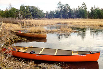
8.4.6 Canoeing / Kayaking
These activities will be encouraged. Canoe and kayak opportunities can be found in Muskrat Creek and along the shores of Lake Nipissing.
Canoeing opportunties in Muskrat Creek
8.4.7 Hunting
The mouth of Muskrat Creek (Muskrat Bay) is a popular waterfowl hunting location. In the past, several blinds for hunting have been placed at the mouth of the creek and are used annually by local hunting guides, tourists and residents.
Hunting is permitted in the NE3 zone (Sections 6.2, 7.1.6 & Map 5). Primary access to this area is by water (e.g. boat, canoe).
8.4.8 Horseback riding
Trails for horseback riding will not be developed in the park.
8.4.9 Mountain biking
Bikes will not be permitted on hiking trails. There are no designated mountain bike trails in the park.
8.4.10 Swimming
Designated swimming areas (i.e. buoyed areas) will not be established, however swimming will be permitted (e.g. Lake Nipissing, Lapin’s & Pebble Beach).
8.4.11 Park fees
Once operational, day-use fees will be required by park visitors (e.g. use of trails, beach, etc). A system to collect fees will be put in place and permit agreements may be formed (Section 10.1).
8.4.12 Camping
The park goal and objectives aim to provide day-use opportunities to complement the existing tourism industry, therefore camping opportunities are currently not available.
Future consideration may be given to develop non-mechanized boat-in/walk-in (e.g. canoe, kayak, hike) campsites (Sections 9.7, 10.1 & 10.2).
8.4.13 Campfires
Campfires will be permitted, in areas designated by the Park Superintendent (Section 10.1). Campfires will be subject to restrictions such as fire bans.
8.4.14 Playgrounds
Playgrounds (e.g. play structures, swings, etc.) will not be established in the park.
8.5 Marketing
Marketing of Mashkinonje Provincial Park will be an on-going endeavour when the park becomes operational.
A Marketing Plan may be prepared for the park by Ontario Parks or in consultation with Ontario Parks (Section 10.1). Mashkinonje Provincial Park would be marketed as a distinctive natural area providing a variety of low-intensity recreational opportunities. Park marketing will follow Ontario Parks standards (e.g. methods, visual identification, approved templates, etc).
The local tourism industry (i.e. local tourist operators) may also market the park as an added value attraction for the area as part of their own marketing strategies (Section 4.3).
A partner may strive to encourage visitation through the following objectives: promote year-round nature-based activities, attract school groups by promoting the natural heritage education element of the park, attract day-use visitors staying at commercial establishments in Sudbury East and West Nipissing, encourage boat trips from the North Bay area, and promote local tourist services and other attractions.
8.6 Tourism services
There are no tourism facilities within the park. New tourism facilities will not be permitted.
Overnight accommodation, rental or sale of recreational equipment and supplies, and recreational services such as air sightseeing tours, and land/water transportation may be provided by the private sector (Section 4.3).
9.0 Development policies
Development will proceed in accordance with the policies of the approved park management plan, Planning and Management Policies, Implementation Plans, Provincial Park Development Standards and approved site and development plans. Approved, detailed site plans will preceed development. MNRs requirements under the Environmental Assessment Act and other pertinent acts will be adhered to.
Where possible, the design and materials used for all facilities constructed within the park will reflect the natural character of the park. Facilities will incorporate environmentally sustainable designs and materials that combine low-maintenance, energy efficiency and durability.
Once the park is operational, Ontario Parks identity signs will be posted along the Highway 64, 69 and 17 corridors (Section 10.2).
9.1 Parking lots and trailheads
Site planning will determine the appropriate size, location and infrastructure for all parking areas. Prior to any development, environmental assessment requirements will be met and archaeological studies will be completed if development will result in the disturbance of undisturbed lands or shorelines (Section 7.3).
Parking for larger vehicles such as school buses will be considered (Section 6.3).
Consistent with the park trail plan, trailheads may display a map of the trail system (Sections 9.2 & 10.1). Minimum impact ethics for park users may be prominently displayed. Toilet facilities will be installed once the park is operational. Development is not restricted to the following phases/order:
Phase 1
The following trailheads will be developed (Sections 6.3, 8.4.3, 9.1, 10.1 & 10.2): Loudon Peatland (A1); Pebble Beach (A3); Lapin’s Beach (A4); the Blandings Access (A5); and Martin Pond (A6). Parking areas and support facilities will be constructed at the Loudon Peatland and Blandings Access trailheads. There will be signs posted for all the trails.
Loudon Peatland Trailhead (A1)
A parking area, which will include pull through sites and a turn around will be developed here. This will provide access for larger vehicles (e.g. buses). Support facilities such as privies, information display/kiosk, signs and access to an interpretive trail and boardwalk into the Loudon Basin Peatland Nature Reserve Zone (NR1) will be developed here.
Pebble Beach (A3)
Primary access is by water. This small staging area will provide access to the park trail system. Support facilities (e.g. display, signs, etc) will be part of this area.
Lapin’s Beach (A4)
Primary access is by water. This small staging area will provide access to the park trail system. Support facilities (e.g. display, signs, etc) will be part of this area.
Blandings access (A5)
A parking area, which will include pull through sites and a turn around will be developed here. This will provide access for larger vehicles (e.g. buses). Support facilities (e.g. privies, information display/kiosk) will be developed here. A small facility may be constructed to provide a 'warm-up' area for winter users.
Walk-in access will be provided to A5 from Samoset Road (A7) (Sections 4.3 & 6.3).
Martin Pond access (A6)
A trailhead for the purposes of walk-in access will be developed (e.g. signs).
Phase 2
Future consideration may be given to the development of a trailhead/small parking area at A2-a and A6.
Muskrat Creek Canoe / Kayak trailhead (A2-a)
This area is located outside of the park (Section 6.3).
Development will be subject to approval from MTO. A small parking area may be developed to provide non-motorized (i.e. canoe/kayak) water access to Muskrat Creek. A canoe/kayak launch may be developed. Support facilities (e.g. display, signs, etc) may be part of this area (Sections 8.4.3, 10.1 & 10.2).
Martin Pond access (A6)
A development strategy will be prepared to consider further developing this trailhead (e.g. parking, information display) (Sections 6.3 A6, 10.1 & 10.2).
9.2 Trails
A trail plan (hiking and cross-country skiing) for the park will be developed by Ontario Parks or in consultation with Ontario Parks to establish a trail-oriented park rich in interpretive themes (Section 10.1). The plan will be approved by Ontario Parks prior to any trail related development. The trails would include a series of gentle trails, as well as a more challenging route along the rugged shoreline of the West Arm and through the interior. Development may be limited to trails, signs (directional and interpretive), viewing platforms, boardwalks/bridges, and privies at designated sites. A sign plan would be a component of the trail plan (Sections 8.4, 9.1 & 10.1). Vehicles including bicycles will be prohibited on trails (Sections 8.4.3, 8.4.8).
Site planning will also consider opportunities to develop a trail for persons with disabilities.
This park management plan identifies a trail system for the park (Sections 8.4.1, 8.4.2 & 8.4.3). Consideration will be given to drainage and the crossing of wet and sensitive areas. Site analysis, approved and detailed site plans must be completed and approved. Environmental assessment requirements will be met prior to any development (e.g. trails, viewing platforms, bridges, boardwalks, campsites, etc) (Sections 7.1.1, 7.1.6 & 10.1).
Trail development in the park is not restricted to the following phases/order:
Phase 1
The following trails will be developed as per approved site plans and environmental assessment requirements:
Loudon Peatland Trail
A series of paths and bridges may traverse the wetlands and a boardwalk and viewing platform may be developed to provide visitors with an opportunity to view the peatlands. Site planning will determine locations to provide a trail to a representative area of the peatland.
Samoset Trail
Boardwalks and bridges may be required, as per the approved site plans and trail plans, to cross wet or sensitive areas. Initial design and development will consider the potential to develop this into a cross-country ski trail.
Martin Pond Trail
Boardwalks may be required, as per the approved site plans and trail plans, to cross wet or sensitive areas and there is potential for a lookout site. Initial design and development will consider the potential to develop this into a cross-country ski trail.
Lapin’s Beach Trail
This trail will form a loop off the Coastal Trail. Boardwalks may be required to cross wet or sensitive areas and there is potential for scenic lookout points. Initial design and development will consider the potential to develop a portion (section of Coastal Trail) of this into a cross-country ski trail.
Pebble Beach Trail
This trail will form a loop off the Coastal Trail. Boardwalks may be required, as per the approved site plans, drainage considerations and trail plans, to cross wet or sensitive areas. There is potential for scenic lookout points. Initial design and development will consider the potential to develop a portion (section of Coastal Trail) of this into a cross-country ski trail.
Heron Trail
Boardwalks may be required, as per the approved site plans, drainage considerations and trail plans, to cross wet or sensitive areas. The trail will avoid the heron rookery. There is potential to develop wildlife viewing areas. Initial design and development will consider the potential to develop a portion (section of Coastal Trail) of this into a cross-country ski trail.
Phase 2
Coastal Trail
The Coastal Trail will be developed as per site analysis, approved and detailed site plans and environmental assessment requirements. Scenic lookout points may be developed. Boardwalks and bridges may be required, as per the approved site plans, drainage considerations and trail plans, to cross wet or sensitive areas. Initial design and development will consider the potential to develop this into a cross-country ski trail (Sections 6.3, 8.4.3, 9.1, 10.1 & 10.2).
Phase 3
Atakas Trail
The final phase will be to complete the Atakas Trail. The trail will be developed as per site analysis, approved and detailed site plans and environmental assessment requirements.
Scenic lookout points may be developed and boardwalks/bridges may be required, as per the approved site plans, drainage considerations and trail plans, to cross wet or sensitive areas. Initial design and development will consider the potential to develop this into a cross-country ski trail. (Sections 6.3 A1 & 8.4.3, 10.1 & 10.2).
Map 6: Mashkinonje Provincial Park Development
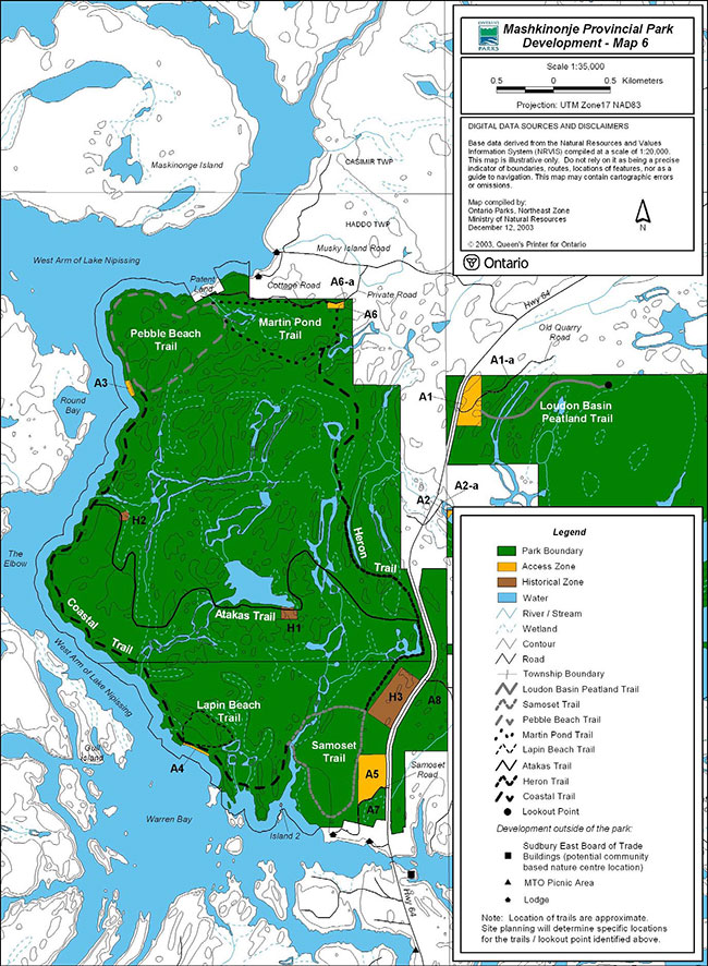
Enlarge Map 6: Mashkinonje Provincial Park Development
9.3 Roads
Provincial Highway 64 dissects the park.
Ontario Parks may establish an agreement with the private road owner and cottagers regarding the road, which provides access to zone A6 (Sections 6.3 & 10.1).
With the exception of roads to access zones (e.g. parking areas), no new roads will be built in the park.
The maintenance/upgrade/closure/rehabilitation of all roads within the park are subject to MNRs policies, procedures, standards and environmental assessment requirements. Prior to any road maintenance/upgrade the Park Superintendent must be consulted. Should any road be abandoned it may be closed and rehabilitated.
Samoset Road
Most of this road is within the park. A work permit was issued by the Sudbury District MNR, prior to the regulation of the Mashkinonje Addition (P170), for the construction and maintenance of Samoset Road. This road provides access to a private lodge and will continue to be maintained by the lodge owners. Prior to any road maintenance the Sudbury District MNR and the Park Superintendent must be consulted. Should this road be abandoned it may be closed and rehabilitated (Sections 6.3 A7 & 10.2).
Cottage Road
Most of this road is within the park. A work permit was issued by the Sudbury District MNR for the construction and maintenance of a cottage road off Musky Island Road. This road provides access to private cottages and will continue to be maintained by the cottage owners. Prior to any road maintenance the Sudbury District MNR and the Park Superintendent must be consulted. Should this road be abandoned it may be closed and rehabilitated (Sections 6.3 A6-a & 10.2).
Old Quarry Road
This road is within the park. Use of the Old Quarry Road pre-existed regulation of the Mashkinonje Addition (P170). Access to private property via the Old Quarry Road will continue, until such time that the access is no longer required. Should this road be abandoned it may be closed and rehabilitated. The road within the park will not be upgraded from its current condition, general maintanence, such as brushing may be permitted. The Park Superintendent must be consulted prior to any work (Sections 6.3 A1-a & 10.2).
Memquisit Road
Memquisit Road is a municipal road, maintained by the Municipality of West Nipissing. Approximately the first 200 metres of the road are within the park and is zoned access to allow motorized use to continue (Section 6.3 A8). The portion of Memquisit Road that runs between the nature reserve zone (NR2) is not within the park (Section 6.1 NR2). Ontario Parks will work with the Municipality to mitigate the impact that any road maintenance may have on the park. Prior to any work on the road (e.g. surface, culverts, etc) within the park, the Municipality must consult with the Park Superintendent.
9.4 Picnic sites
There are no designated picnic sites within the park. Future consideration may be given to establish small picnic sites along the shoreline of the West Arm of Lake Nipissing (Sections 10.1 & 10.2).
There is a MTO picnic site located outside the park (Map 2).
9.5 Boat launch
There are no designated boat launches within the park. No new boat launches will be developed in the park. The closest boat launch is located approximately 1.5 kilometres south of the park along Highway 64 (Map 2). This boat launch is operated by the Department of Fisheries and Oceans (DFO). Visitors to commercial establishments surrounding the park may be able to access the West Arm via private boat launches.
9.6 Community based nature centre
A community based nature centre may be established at a property currently owned by the Sudbury East Board of Trade. This property is located south of the park on the West Arm of Lake Nipissing (former Lands and Forest Headquarters). Should opportunities at this facility complement park objectives and management policies, Ontario Parks may work in partnership to support use of the site (Section 10.1 & Map 2).
9.7 Boat-In / Walk-In camping
Presently camping is not permitted, however in the future non-mechanized boat-in/walk-in (i.e. hike, canoe, kayak) campsites may be established in the park (Sections 8.4.12, 10.1 & 10.2). As a minimum, provincial operating standards for the development of campsites will be met. Site analysis, approved and detailed site plans and environmental assessment requirements will be completed prior to any development. Pit privies are considered part of the campsite.
9.8 Docking facilities
Docking facilities will be considered at A3 and A4 to reduce visitor impact on the shoreline and vegetation (Sections 10.1 & 10.2).
Site analysis, approved and detailed site plans and environmental assessment requirements will be met prior to any development.
10.0 Implementation strategy
Implementation of the park management plan involves updating the Park Operating Plan on an ongoing basis, undertaking resource management plans and carrying out natural heritage education planning. Development of approved facilities will be based mainly on MNRs Environmental Assessment Act requirements, site planning, work program planning and outside funding by partners.
The following is a summary of projects that have been identified in this park management plan:
10.1 Operational and minor capital projects
This section will provide basic guidelines for future development and operations. Further information for each project is provided in the Section(s) noted after each point. The following are not listed in order of priority.
Administration / Operations
- Regulate Mashkinonje Provincial Park and the Mashkinonje Addition (P170) as one park under the Provincial Parks Act (Section 5.0)
- Consider protection of values extending beyond park boundary through conservation easements (Section 5.0)
- Consider the aqcuisition of property as an addition to the park on a case-by-case basis (Section 5.0)
- Sign the park boundary (Section 5.0)
- Consider ARDA lands as an addition to the park (Section 5.1)
- Amend the policy reports (Mashkinonje & Mashkinonje Addition) in the Crown Land Use Policy Atlas to reflect the direction in the park management plan (Section 7.0)
- The Park Superintendent will work with forest management interests, the Ministry of Northern Development and Mines, MNR and other agencies to minimize, control and mitigate the impact of adjacent land uses on the park environment and park visitor experiences (Section 7.1.3)
- The Park Superintendent will work with MNR District staff and the forest companies to ensure that the park and its values are considered during forest management planning (Section 7.1.3)
- The Park Superintendent will work with municipalities and MTO to minimize, control and mitigate the impact of flooding on roads within/adjacent to the park (Section 7.1.3)
- The Park Superintendent will work with adjacent land owners, municipalities and the Ministry of Agriculture, Food & Rural Affairs to minimize, control and mitigate the impact of drainage on the watersheds which flow into the park (Section 7.1.3)
Monitor drainage to ensure protection of park environment (Section 7.1.3) - The Park Superintendent will work with MTO to minimize, control and mitigate the impact of spraying chemical herbicides along the Highway 64 corridor within the park (Section 7.1.5)
- The Park Superintendent will work with Municipalities to minimize, control and mitigate the impact of any road maintenance (e.g. tending, spraying, etc.) may have on the park (Section 7.1.5)
- Phase out existing commercial fur harvesting within nature reserve zones (NR3) located in the park boundary regulated prior to July 1999, by January 1, 2010 (Section 7.1.6)
- Develop a access agreements with commercial fur harvesters and commercial bait fish harvesters to minimize, control and mitigate the impact of motorized vehicles on park values (Sections 7.1.6, 7.2.1 & 8.4.5)
- Submit amendment to Fish & Wildlife Conservation Act to reflect no hunting in nature reserve zones identified within Mashkinonje Addition (P170) and within the Mashkinonje Addition in Haddo Township (NE2) (Section 7.1.6)
- The Park Superintendent will work with District MNR to amend bear management areas and bait fishing areas (Sections 7.1.6 & 7.2.1)
- The Park Superintendent will work with the community, Sturgeon-Nipissing-French Water Management Advisory Board and Public Works and Government Services to regulate and minimize, control and mitigate the impact of fluctuating water levels on the park (Section 7.2)
- Establish a regulation under the Fisheries Act to not permit the use or possession of bait fish within waterbodies wholly contained within the park (Section 7.2.1)
- Phase out existing commercial bait fish harvesting within nature reserve zones (NR3) located in the park boundary regulated prior to July 1999, by January 1, 2010 (Section 7.2.1)
- Prepare a business plan for the park (Section 8.0)
- Prepare a park operating plan and update as required (Section 8.0)
- Consider establishing a formal Partnership Agreement (Sections 8.0 & 8.1)
- Prepare a natural heritage education plan (Section 8.2)
- Consider developing kiosks at A1 & A5 (Sections 8.2 & 9.1)
- Develop a trail plan (hiking & cross-country skiing) and include direction for signage (interpretive and directional) of the park trail system (Sections 8.4 & 9.2)
- Consider developing cross-country ski trails and 'warm-up' facility (Sections 8.4.2 & 9.2)
- Consider partnership to groom ski trails (Sections 8.4.2 & 8.4.5)
- The Park Superintendent will work with the snowmobile club to ensure that the trail, where appropriate, is located outside of the park (Section 8.4.5)
- Establish a system and agreement to collect fees (Section 8.4.11)
- Consider non-mechanized boat-in/walk-in campsites (Sections 6.2, 8.4.12 & 9.7)
- The Park Superintendent may designate areas for campfires (Section 8.4.13)
- Prepare a marketing plan (Section 8.5)
- Consider development of small parking area at Muskrat Creek Access (A2-a) (Section 9.1)
- Consider an agreement with private road owner (off Musky Island Road) to use the road (Section 9.2)
- Consider development of picnic sites in park (Sections 9.4 & 10.2)
- Work in partnership with community based nature centre if facility complements park objectives and management policies (Section 9.6)
- Consider development of docking facilities at A3 & A4 (Section 9.8)
Development
- Prepare site plans and meet EA requirements for the development of the trailheads/parking areas (Sections 6.3, 8.4.3, 9.1 & 10.2):
- Blandings Access (A5)
- Loudon Peatland Trailhead (A1)
- Pebble Beach (A3)
- Lapin Beach (A4)
- With approval from MTO, prepare site plans and meet EA requirements to develop a canoe/kayak launch, parking area and appropriate signage at Muskrat Creek (Sections 6.3 A2-a, 8.4.3, 9.1 & 10.2)
- Prepare site plans and meet EA requirements to develop walk-in access from Martin Pond (A6) to park trail system and from A7 to A5 (Sections 6.3 A5,A6 & A7, 8.4.3 & 9.3)
Prepare development strategy to consider a parking area at A6 (Sections 6.3 & 9.1) - Prepare site plans and meet EA requirements for the development of the park trail system (Sections 8.4.3 & 9.2):
- Pebble Beach Trail
- Lapin’s Beach Trail
- Coastal Trail
- AtakasTrail
- Martin Pond Trail
- Samoset Trail
- Loudon Peatland Trail
- Heron Trail
- If determined that camping is acceptable, develop site plans and meet EA requirements for the development of campsites in the park (Sections 8.4.12 & 9.7)
Resource management
- Prepare a vegetation stewardship plan, include direction for vegetation restoration, protection of provincially significant species, monitoring and inventories (Section 7.1.5)
Develop strategy for control of non-native plants (Section 7.1.5) - Prepare a fire management plan, include direction on prescribed burning (Section 7.1.5)
- Prepare a wildlife stewardship plan. Address management of provincially significant species, species at risk, inventories and species monitoring (Section 7.1.6)
- Complete studies/inventories to identify and manage species at risk in the park (Sections 7.1.6 & 8.3)
- Encourage research (e.g. archaeological, cultural/historical, earth science, etc) consistent with the park policy (Section 8.3)
10.2 Operational and major capital projects
This section will provide direction for basic facilities to encourage a more stable and positive financial contribution to the parks system. Further information for each project is provided in the Section(s) noted after each point.
The following is not listed in order of priority:
Administration/operations
- If determined that the ARDA lands are to be added to the park (Section 5.1):
- Regulate as part of the park
- Consider zoning area nature reserve
- Prepare an amendment to this plan
- Post Ontario Parks identity signs along the Highway 69 and 17 corridors (Section 9.0)
Development
- Complete archaeological assessments for development projects which will alter undisturbed lands or shorelines (Section 7.3)
- As per approved site plans and EA requirements, develop trailheads/parking areas at the following locations (Sections 6.3, 8.4.3, 9.1 & 10.2):
- Blandings Access (A5)
- Loudon Peatland Trailhead (A1)
- Pebble Beach (A3)
- Lapin Beach (A4)
- As per approved site plans and EA requirements, develop Muskrat Creek Access (Sections 6.3 A2-a & 9.1)
As per approved site plans and EA requirements, develop canoe/kayak launch (Sections 6.3 A2-a & 9.1) - As per approved site plans and EA requirements, develop the park trail system (Sections 8.4.3 & 9.2):
- Pebble Beach Trail
- Lapin’s Beach Trail
- Coastal Trail
- Atakas Trail
- Martin Pond Trail
- Samoset Trail
- Loudon Peatland Trail
- Heron Trail
- As per approved site plans and EA requirements, develop toilet facilities once park is operational (Section 9.1)
- As per approved site plans and EA requirements, close and rehabilitate abondoned roads (Section 9.2)
- As per approved site plans and EA requirements, implement findings of the development strategy which considered the development of a trailhead at A6 (Sections 6.3, 9.1 & 10.1)
- As per approved site plans and EA requirements, develop non-mechanized boat-in /walk-in campsites (Sections 6.2, 8.4.12, 9.7 & 10.1)
- As per approved site plans and EA requirements, implement findings for the development of picnic sites (Sections 9.4 & 10.1)
- As per approved site plans and EA requirmenents develop docking facilities (Section 9.8)
11.0 Social and economic benefits
Mashkinonje Provincial Park may be an important part of the area’s tourism infrastructure.
The projects and activities identified in this park management plan generally provide a host of social and economic benefits, both within the park and in the surrounding area.
The following are important benefits and help to demonstrate how the park exports our quality of life in Ontario:
- Protection and contribution to ecological functions (water and soil production)
- Protection of resource integrity (some of the last green spaces left in the province)
- Health effects from use of parks (mental, physical, spiritual benefits)
- Worker productivity (healthy and happy workers tend to be more productive – a visit to a provincial park can contribute)
- Educational benefits (young and old learning about our environment)
- Scientific benefits (research in provincial parks)
- International responsibilities to protect natural settings, features and wildlife; and
- Business location decisions (quality of life/business) and community cohesion
12.0 Plan review and amendment
The approved Mashkinonje Park Management Plan will be reviewed on an ongoing basis throughout its twenty year life span to address issues or changing conditions. All management plan reviews will incorporate further opportunities for full public consultation.
The review will be implemented in the following manner:
- Review initial management planning process
- Update background information and data on park resouces and park use
- Review plan implementation and provincial policies
- Identify new issues and concerns
- Prepare issues and solutions document for public review; and
- Review and receive approval for plan amendments
A park management plan amendment involves proposed changes to the plan’s management or development policies, consistent with the classification, zoning, goal and objectives. Amendments can be either major or minor and may be processed to correct existing or include new information (PM 11.02.03, Ontario Parks Policy, 1992).
13.0 Public concultation
In January 1998, a committee with interest in the park, through the Sudbury East Board of Trade, approached Ontario Parks about the potential to develop the park as an ecotourism attraction in the West Arm area of Lake Nipissing. Ontario Parks indicated that a park management plan would be required prior to any development within the park, and that development and operation would have to conform to provincial park policies and standards. The Sudbury East Board of Trade submitted a proposal to sponsor this planning initiative in cooperation with Ontario Parks and other partners. Human Resources Development Canada, FedNor, the Ministry of Training, Colleges and Universities, as well as numerous in kind contributors provided the funding necessary to complete an ecological inventory of the park and prepare the park management plan.
Public involvement in the development of the Mashkinonje Park Management Plan began during the fall of 1998 when the Sudbury East Board of Trade took on the responsibility of commencing the management planning process for Mashkinonje Provincial Park. The Sudbury East Board of Trade immediately began a public awareness campaign introducing the possibility of developing Mashkinonje Provincial Park into an ecotourism attraction for the area.
Background information on management planning for Mashkinonje Provincial Park was compiled from 1998-2001.
The first stage of the planning process was to develop a Terms of Reference. This document provided timelines for the planning process. The Terms of Reference was approved December 28, 2000 by the Managing Director of Ontario Parks. Following the approval a public notice was placed in local newspapers (March 2001) inviting a 45 day opportunity for public review and comment on the Terms of Reference and Background Information. A total of seventeen written and verbal responses were received during this review.
Local interest and support for Mashkinonje Provincial Park has resulted in presentations and media interviews. Presentations were made to the Sudbury East Planning Board, Municipalities of French River, West Nipissing, St. Charles and Markstay/Warren during the summer of 2001. CBC Radio, MCTV, Sturgeon Falls Tribune, Sudbury Star and the North Bay Nugget have conducted interviews/written articles regarding the local interests in Mashkinonje Provincial Park. The next stage of the process was the preparation of a preliminary park management plan. The Managing Director of Ontario Parks approved the Mashkinonje Preliminary Park Management Plan (2002) on June 23, 2002. The preliminary plan was released for public inspection and comment (September 18 - November 4, 2002). Several supportive articles regarding the park and the preliminary park management plan were written in local newspapers. During the public inspection period 31 written responses were received. Overall, the comments were supportive of the management direction identified for Mashkinonje Provincial Park. Most public comments were general, however some were specific to zoning, hunting, trapping, mechanized use and trails.
All comments regarding the Mashkinonje Preliminary Park Management Plan (2002) were considered during the development of this approved park management plan.
The methods of consultation utilized during the planning process were:
Mailing lists
- Mandatory Mailing List – as per Provincial Park Policy (PM 11.02.02)
- Adjacent property owners (as per Exemption Order 59/2)
- Dokis First Nation
- Commercial fur harvester, commercial bait fish harvesters and adjacent bear management area operators
- Mailing list of local residents and businesses
- Individuals who requested to be put on the mailing list; and
- Distribution in mail boxes in French River, Lavigne and St. Charles area
Newspaper notices
Newspaper notices in the following newspapers:
- English Language: Sudbury Star, Ad-vantage Plus (Sturgeon Falls), North Bay Nugget
- French Language: Le Voyageur Press (Sudbury), La Tribune (Sturgeon Falls)
Posted notices
Notices of meetings and current stages of consultation posted in various businesses throughout Sudbury East.
Environmental Bill of Rights (EBR) registry:
EBR notices posted to provide opportunities for the public to comment.
Ontario government:
During public consultation, all Mashkinonje Provincial Park management planning documents were available at the Ontario Parks Northeast Zone office, and the Sudbury and North Bay MNR District offices.
The approved plan is available on the Ontario Parks website www.ontarioparks.com.
14.0 References
Agricultural Rural Development Agreement, 1960s.
Exemption Order MNR-62, 1995. Wildlife Rabies Control Program.
Exemption Order MNR 59/2, 1992. Carrying out of the Provincial Parks Program.
Endangered Species Act, 1990.
Environmental Assessment Act, 1990.
Environmental Bill of Rights, 1993.
Fisheries Act, 1985.
Fish and Wildlife Conservation Act, 1997.
Freedom of Information and Protection of Privacy Act, 1987.
Hills, G.A., July 1959. A Ready Reference to the Description of the Land of Ontario and its Productivity. Division of Research, Ontario Department of Lands and Forests, Maple, Ontario.
Kershaw, M. & Hawes, K.J., December 1999. Natural Science Inventory of Mashkinonje Provincial Park and Proposed Park Additions.
Lake Nipissing Fisheries Management Plan (1999- 2003), North Bay District MNR.
Migratory Birds Convention Act, 1994.
Nipissing Forest Management Plan, 1999-2004.
Off-Road Vehicles Act, 1990.
Ontario Ministry of Natural Resources, Provincial Park Development Standards.
Ontario Ministry of Natural Resources, Provincial Parks Operational Policies, Procedures & Bulletins.
Ontario Ministry of Natural Resources, 2003. Ontario Recreational Fishing Regulations Summary. Queen’s Printer for Ontario.
Ontario Ministry of Natural Resources, Fall 2002- Spring 2003. Ontario Hunting Regulations Summary. Queen’s Printer for Ontario.
Ontario Ministry of Natural Resources, January 2002. Draft Fire Management Strategy for Ontario.
Ontario Ministry of Natural Resources, July 1999. Ontario’s Living Legacy Land Use Strategy.
Ontario Ministry of Natural Resources, Design Manual Buildings and Structures, Vol. 1, 1999.
Ontario Ministry of Natural Resources, 1997. Northern Ontario Wetlands Evaluation, Data and Scoring Records.
Ontario Ministry of Natural Resources, Barrier Free Guidelines Design Manual, Vol. 3, 1996.
Ontario Ministry of Natural Resources, 1994. Provincial Parks Management Planning Manual.
Ontario Ministry of Natural Resources, March 1994. Mashkinonje Provincial Park Interi Management Statement.
Ontario Ministry of Natural Resources, 1992. Ontario Provincial Parks Planning and Management Policies. Toronto.
Ontario Ministry of Natural Resources, Ontario Provincial Parks Operating Standards (1985/revised 1992/revised 1995).
Provincial Parks Act , 1990.
Public Works and Government Services, September 1995. Lake Nipissing/French River Operational Guidelines. Acres International Limited, Niagara Falls.
Slattery, Dr. David J. G., 2003. Interim Stage One and Two Archaeological and Heritage Impact Assessment Mashkinonje Provincial Park, Trail Heads and Trails.
Sturgeon – Nipissing – French Water Management Advisory Board/Ontario Ministry of Natural Resources, March 1992. Sturgeon River/Lake Nipissing/French River Water Management Plan. Acres International Limited, Niagara Falls.
Sudbury Forest Management Plan, 2000-2005
Footnotes
- footnote[1] Back to paragraph Reference to Mashkinonje Provincial Park means both the park boundary regulated prior to July 1999, as well as the regulated Mashkinonje Addition (P170), unless specifically stated otherwise.
- footnote[2] Back to paragraph Ontario is divided into 13 ecoregions. An ecoregion is an area of land within which the response of vegetation to the features of landform follows a consistent pattern. Ecoregion 5E is called Georgian Bay.
- footnote[3] Back to paragraph Ontario is divided into 65 ecodistricts. An ecodistrict is a subdivision of an ecoregion based on a characteristic pattern of physiographic features, which set apart fairly large areas from one another. Ecodistrict 5E-5 is called North Bay.