Masonville Bernhardt Muskeg Maple Moraine Conservation Reserve Management Statement
This document provides policy direction for the protection, development and management of the Masonville Bernhardt Muskeg Maple Moraine Conservation Reserve and its resources.
October 2003
Kirkland Lake District
Approval statement
I am pleased to approve this Statement of Conservation Interest (SCI) for the Masonville Bernhardt Muskeg Maple Moraine Conservation Reserve.
Direction for establishing, planning and managing conservation reserves is defined under the Public Lands Act, the Ontario’s Living Legacy Land Use Strategy, and other applicable policies. The specific direction for managing this conservation reserve is in the form of a basic SCI, which defines the area to which the plan applies, provides the purpose for which the conservation reserve has been proposed, and outlines the Ministry of Natural Resources’ management intent for the protected area. This SCI has been created with input from program specialists within Kirkland Lake District.
This SCI will provide guidance for the management of the conservation reserve and the basis for the ongoing monitoring of activities. More detailed direction at this time is not anticipated. Should significant facility development be considered or complex issues arise requiring additional studies, more defined management direction, or special protection measures, then a more detailed Resource Management Plan will be prepared with full public consultation.
Public and Aboriginal consultation occurred prior to the regulation of this conservation reserve. Furthermore, the public was notified during a 30 day period commencing November 15, 2004 concerning a draft of this SCI. Comments from the notification period have been considered in the development of this document.
The Masonville Bernhardt Muskeg Maple Moraine Conservation Reserve will be managed under the jurisdiction of the Kirkland Lake / Claybelt Area Supervisor of the Ministry of Natural Resources, Kirkland Lake District.
Plan Author:
Jennifer Telford, Ontario’s Living Legacy Resource Manager
Jessica Malone, Land Use Planning Intern
Kirkland Lake District
Approved and signed by:
Corrinne Nelson, District Manager
Date: March 24, 2005
Approved and signed by:
Rob Galloway, Regional Director
Date: April 24, 2005
1.0 Introduction
Ontario’s network of natural heritage areas has been established to protect and conserve areas representative of the diversity of the natural regions of the province, including species, habitats, features and ecological systems which comprise that natural diversity. Protected natural heritage areas are a key component in sustainable management of natural resources. They ensure that representative sites within the larger sustainably managed landscape are permanently retained in their natural state.
Natural Heritage areas are considered to be sensitive, requiring protection from incompatible activities if their values are to endure over time. The Ministry of Natural Resources has established conservation reserves as a new tool to offer protection for these areas on public lands, while permitting many traditional public lands uses to continue. Such uses include the traditional activities of Aboriginal Peoples.
Ontario’s Living Legacy Land Use Strategy (OLL LUS) (MNR, 1999) and the Crown Land Use Policy Atlas sets the direction for the administration and management of parks and protected areas on Crown lands within three planning regions including the Boreal West, Boreal East and Great Lakes - St. Lawrence areas. This strategy’s natural heritage objectives include protection of natural and cultural heritage values and the provision of opportunities for outdoor recreation, heritage appreciation and tourism (MNR, 1999).
Protected areas designated within the OLL LUS have been selected based on their representation of the spectrum of the province’s ecosystems and natural features including both biological and geological features, while minimizing impacts on other land uses. Representation was described using landform and vegetation combinations based on Hill’s (1959) site district concept.
The Masonville Bernhardt Muskeg Maple Moraine Conservation Reserve is a 128 ha parcel of Crown Land that is situated approximately 15 km northwest of Kirkland Lake. It is found within Bernhardt Township along the edge of Masonville Township. These townships are located in the Kirkland Lake District within the MNR’s Northeast Region (see Locator Map within Appendix 3). The site was regulated with the filing of Ontario Regulation 86/01 made under the Public Lands Act on April 4, 2001. The conservation reserve will be managed under a Statement of Conservation Interest (SCI).
SCI documents are the minimum level of management direction established for any conservation reserve and generally are brief management plans. This SCI will govern the lands and waters within the regulated boundaries of the Masonville Bernhardt Muskeg Maple Moraine Conservation Reserve. However, to ensure MNR protection objectives are being fully met within the conservation reserve, the surrounding landscape and related activities should consider the site’s objectives and heritage values. In addition, it is the intent of the SCI to create public awareness that will promote responsible stewardship of protected areas and surrounding lands. With management partners such as Ontario Parks, industry and local governments, MNR District staff will be able to pursue and advance sound environmental, economic and social strategies and policies related to the protection of conservation reserves and provincial parks.
The purpose of this SCI is to identify and describe the values of the Masonville Bernhardt Muskeg Maple Moraine Conservation Reserve and outline the Ministry’s management intent for the conservation reserve. The management direction will protect the site’s natural heritage values and demonstrate its compatibility within the larger sustainable landscape. This direction will comply with land use intent as stated by the OLL Land Use Strategy (MNR, 1999).
2.0 Goals and objectives
2.1 Goal of Statement of Conservation Interest
The goal of this SCI is to describe and protect natural heritage values on public lands while permitting compatible land use strategies. This Statement of Conservation Interest is intended to guide the management decisions that will ensure the Masonville Bernhardt Musket Maple Moraine Conservation Reserve will meet this goal through both short and long-term objectives.
2.2 Objectives of SCI
2.2.1 Short term objectives
The short-term objectives are to identify the State of Resource with respect to natural heritage values and current land use activities for the Masonville Bernhardt Muskeg Maple Moraine Conservation Reserve. A priority will be placed on the protection of the site’s natural values via specific guidelines, strategies and prescriptions detailed in this plan. Finally, legislated planning requirements will be met (i.e. SCI development within three years of regulation).
2.2.2 Long term objectives
The long-term objectives will be to establish representative targets (e.g. future forest conditions) and validate the site as a potential scientific benchmark. To ensure protection of natural and cultural heritage features and values, this SCI will establish an evaluation process to address future new uses and commercial activities associated with them (e.g. Test of Compatibility Procedural Guideline B in Conservation Reserve Policy PL 3.03.05). Finally, this SCI will identify research/client services and marketing strategies and give direction to evaluate future new uses or economic ventures.
3.0 Management planning
3.1 Planning area
The planning area for this site will consist of the area within the regulated boundary for the Masonville Bernhardt Muskeg Maple Moraine Conservation Reserve (See Locator Map, Appendix #7). This landbase will form the area directly influenced by this SCI. The SCI will recognize the protection of values within the planning area; however, to fully protect values within the conservation reserve, the lands beyond the regulated boundaries may require additional consideration within larger land use or resource management plans. Nevertheless, any strategies noted within this plan related to the site’s boundary or beyond will need to be presented for consideration within a larger planning context.
3.2 Management planning context
The Masonville Bernhardt Muskeg Maple Moraine Conservation Reserve was first designated as a candidate conservation reserve by MNR in the OLL Proposed Land Use Strategy (MNR March, 1999) and ultimately as a conservation reserve in the final OLL Land Use Strategy (MNR, 1999). The site was regulated with the filing of Ontario Regulation 86/01 made under the Public Lands Act on April 4, 2001. Management and planning direction for this site will follow the OLL LUS (MNR, 1999) and this management statement. The area encompassed by this site has also been removed from the Timiskaming Forest Alliance Inc. Sustainable Forest License (SFL) landbase.
By regulation this conservation reserve cannot be used for commercial forest harvest, mining or hydroelectric power development (MNR, 1999). Existing permitted uses within this reserve may continue such as fishing, hunting and trapping. This SCI document and future management will continue to attempt resolution of conflicts regarding incompatibility between uses and to ensure that identified values are adequately protected.
This SCI will only address known issues or current proposals with respect to permitted uses or potential economic opportunities brought forward to the District Manager during this planning stage. However, in terms of approving future permitted uses and/or development(s), there are established mechanisms in place to address such proposals. Any future proposals will be reviewed using the Procedural Guideline B-Land Uses-Test of Compatibility Public Lands Act Policy PL 3.03.05 (MNR, 1997) or other standard MNR environmental screening processes.
Consideration of proposals pertaining to cultural resources may be screened through Conserving a Future for our Past: Archaeology, Land Use Planning & Development in Ontario, Section 3 (MCzCR, 1997), or in processes such as that used by MNR to establish Area of Concern (AOC) descriptions and prescriptions for cultural heritage resources within Forest Management Plans (FMPs).
These planning tools will help refine the review process once the proposal satisfies the direction and intent of the Public Lands Act, associated policies and this planning document.
3.3 Planning process
Once a conservation reserve is passed into regulation, it must be determined what level of management planning is required to fulfill the protection targets. There are two policy documents involved. A SCI is the minimal requirement for providing planning direction. A Resource Management Plan (RMP) deals with more complex issues where several conflicting demands are placed on the resources. The guidelines for the preparation of these documents are outlined in Procedural Guideline A-Resource Management Planning (Conservation Reserves Procedure PL 3.03.05 Public Lands Act). The appropriate plan must be completed within three years of the regulation date.
For current planning purposes, the Masonville Bernhardt Muskeg Maple Moraine Conservation Reserve will be managed under the auspices of a basic SCI. Interested parties from both the private and public sector were consulted during the planning process from candidate conservation reserve to regulation. The public was widely consulted during the regulation process and further consultation is not required at this time. In addition, a public notification of a draft of this SCI document occurred for a period of 30 days beginning November 20, 2004. The intent of this SCI is to fulfill the commitments made within the OLL LUS (MNR, 1999).
The revised SCI was reviewed by representatives from the Lands, Forestry, Fish & Wildlife, and Aboriginal programs, the District Planner, the Information Supervisor and the Elk Lake - Matheson Area Supervisor. Upon approval by the Kirkland Lake District Manager (DM) the SCI was presented to the Regional Director (RD) for final approval.
Public consultation will be solicited as part of any future reviews of land use proposals that would require new decisions to be made. In addition, any new significant management direction considered will be published on the Environmental Bill of Rights Registry (EBR).
The SCI is a planning document that will provide background information, identify values to be protected and establish management guidelines for use in the administration of the reserve.
The implementation of the SCI will be the mandate of the MNR at the District level; however associations with various partners may be sought to assist in the delivery. This SCI is a working document, and as a result, it may be necessary to make revisions to it from time to time through the amendment process.
4.0 Background information
4.1 Location and site description
4.1.1 Location
The following table describes the location and provides administrative details of the Masonville Bernhardt Muskeg Maple Moraine Conservation Reserve:
Table 1: Location data
Table 1 reformatted into a list
- Name: C1615 Masonville Bernhardt Muskeg Maple Moraine
- Site EcoRegion - Site EcoDistrict (Hills, 1959; Crins, 2000): Lake Abitibi Ecoregion, Kirkland Lake Ecodistrict 3E-6
- MNR Administrative Region/District Area: Northeast Region/Kirkland Lake District in the Kirkland Lake/Claybelt Area
- Total Area: 128 ha
- UTM co-ordinates: Zone 17, NAD 83,564011 m E, 5340530 m N
- Nearest Town/Municipality: Kirkland Lake
- Township(s): Bernhardt
- OBM Numbers: 17-540053400
- Topographical Map Name/Number: Kirkland Lake 42 A/1
- Wildlife Management Unit: 28
- Forest Management Unit: Timiskaming
4.1.2 Site description
The Masonville Bernhardt Muskeg Maple Moraine Conservation Reserve is located approximately 15 km northwest of the town of Kirkland Lake, Ontario, and consists of 128 hectares of land. This site is found within the Bernhardt Township in the District of Timiskaming (Locator Map, Appendix #7). The Conservation Reserve is located in Hills’ Kirkland Lake Ecodistrict 3E-6 (Hills, 1959), which is characterized by moderately broken plains of granitic and lowbase bedrock with a thin cover of granitic and low-based sand and silty-sand. The conservation reserve has a landform base of weakly broken ground moraine.
The site’s boundaries are vectored
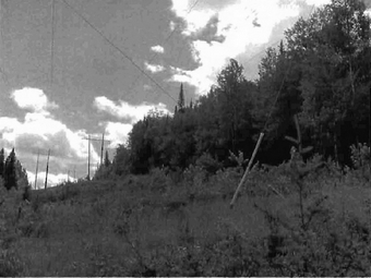
The forests represented within the Masonville Bernhardt Muskeg Maple Moraine Conservation Reserve consist mainly of red and silver maple (Map 2a, Appendix #8). Black spruce, jack pine, white birch and trembling aspen are also found within the conservation reserve. During aerial reconnaissance Thompson (2001) observed that the maple mixedwood forests contained more trembling aspen and white birch with conifers being found more to the south. Stands of jack pine on the western edge of the site and stands of black spruce in the south were all harvested recently. There has been little regeneration in these areas to date. Also, an old growth stand of white birch, 100-140 years of age (Uhlig, 2001) was harvested. These areas were harvested in 1996/97.
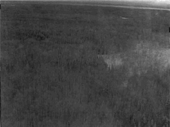
The wetlands for the Masonville Bernhardt Muskeg Maple Moraine Conservation Reserve are limited to an area of poor fen in the southwestern corner of the site (Map 3b, Appendix #8).
4.2 Administrative description
The legal boundaries of the Masonville Bernhardt Muskeg Maple Moraine Conservation Reserve were filed on January 10, 2001 with the Office of the Surveyor General, Ministry of Natural Resources in Peterborough, Ontario. This site was passed into regulation on April 4, 2001 (O.Reg. 86/01). It falls within the Kirkland Lake / Claybelt area of the Ontario Ministry of Natural Resources Kirkland Lake District and is included in SFL 542247 held by the Temiskaming Forest Alliance Inc..
4.3 History of site
Historically the site has been used for wildlife activities. The site contains one Bear Management Area (BMA) and one active trapline. Timber harvesting has also occurred within site boundaries as mentioned above.
4.4 Inventories
The following table indicates the natural heritage inventory that has occurred or is required in the near future.
Table 2. Inventory data
| Type of Inventory | Method | Date | Report |
|---|---|---|---|
| Life Science | Aerial Reconnaissance | August 2002 | B. Burkhart; OMNR, S. Longyear; OMNR & L. King OMNR |
| Earth Science | Aerial Reconnaissance | August 2002 | R. Kristjannson |
| Recreation | Aerial Reconnaissance | November 2003 | J. Telford, OMNR |
5.0 State of the resource
5.0.1 Representation
The Masonville Bernhardt Muskeg Maple Moraine Conservation Reserve consists of mixed hardwood stands. The dominant hardwood in the conservation reserve is maple. Conifers, trembling aspen and white birch are also found within the site. Recent logging has depleted the old growth (100-140 year old) white birch in the site along with the old growth jack pine (110-180 year old (Uhlig, 2001)) and old growth black spruce stands (120-170 (Uhlig, 2001)).
Access to the site can be gained along the hydro corridor and accompanying snowmobile trail and by logging road. Access directly into the site can be gained by all-terrain vehicle (ATV) or snowmobile.
5.0.2 Quality of representation
The quality of the representation or the current characteristics of the natural features found within the conservation reserve are as important as the overall representative features that are being protected. A number of factors are considered in evaluating a site and they include the following criteria: diversity, condition, ecological factors, special features and current land use activities.
a) Diversity:
Diversity is a measure of the site’s Life and Earth Science heterogeneity. The evaluation is based on the number and range (variety) of the natural landscape features and landforms for Earth Science values and the relative richness and evenness of the site’s Life Science components. Natural landscapes and known generalized vegetation communities will be the scale used for this SCI. Future aerial or ground reconnaissance surveys will enhance the MNR’s knowledge of these features and possibly allow verification at a lower scale (e.g. species assemblages).
Diversity for this site has been rated as low. This is due to the dominance of two forest types and the small size of the other forest communities within the site. The dominant maple and mixedwood maple forests account for 65% of the total site area. The following forest communities are less than five hectares and are found on the perimeter of the site: jack pine predominant, poplar mixedwood and black spruce dominant conifer.
b) Condition:
Condition is the degree of past human and natural disturbance observed or recorded for the site. Disturbance is rated as moderate for this site. Part of the site has been recently harvested. Jack pine, white birch and black spruce in the northwest corner and in part of the south was harvested during the 1996/97 operating year. There is evidence of chemical tending along the southern border of the site. The hydro line corridor along the east border is another disturbance evident near the site. A snowmobile trail runs along the hydro corridor and is a winter disturbance to the site.
c) Ecological factors:
Ecological factors refer to the current design of the CR as noted by its size, shape, and ability to protect core ecosystems from adjacent land use activities. Whenever possible, a site’s boundaries should be created to include the greatest diversity of life and earth science features to provide the maximum ecological integrity. It should be ecologically self-contained, bound by natural features and include adequate area to protect the core ecosystems from intrusive adjacent land use influences (OMNR 1992).
This site does not have any natural boundaries. The vectored and township boundaries make it difficult to mark where the conservation reserve begins and ends. Extending the boundary of the conservation reserve to include part of the shoreline of Wendtwright Lake would add a natural boundary and increase the diversity of the site.
The size of the site inhibits its capacity to protect core communities within the conservation reserve. Ecosystem protection for this site is nearly non-existent because of logging on two sides of the site and the hydro corridor to the east.
d) Special features:
The major feature that is present within this conservation reserve is:
- Dominant maple and mixedwood maple forests.
e) Current land use activities
Only a small number of uses are known to be associated with this site. Activities include hunting, trapping, ATV use, and snowmobiling. A number of moose stands have been observed on trails around the conservation reserve. There is a trail that runs through the northwest corner of the site (See Access Map, Appendix #7). It leads to the snowmobile trail and is assumed to be a winter access trail. The trail was accessed by ATV in the summer but it was not an easily passable trail.
5.0.3 Summary
The Masonville Bernhardt Muskeg Maple Moraine Conservation Reserve is a very small site with a limited capacity for recreation. The site has access via the hydro corridor and accompanying snowmobile trail. Logging roads also provide access to the site. Disturbances within the site include logged sections of forest in the northwestern and southern areas of the conservation reserve and chemical tending along the southern border of the site. The large areas that have been logged around and in the site reduce the protection of the forest communities within the conservation reserve until regeneration occurs. The hydro line corridor provides a permanent disturbance to the eastern edge of the site.
5.0.4 Natural heritage representative features
This site contains mixedwood and dominant maple forests that cover more than 65% of the conservation reserve. Bedrock-Drift Complexes with continuous or discontinuous till are the main landforms. Organic deposits are found in the southwestern edge of the site. The old growth communities listed in Map 2c, Appendix #8 have been logged (see Map 5 Appendix #8). These areas contained old growth white birch, jack pine and black spruce. Regeneration of these areas is sparse with little jack pine or spruce visible during aerial reconnaissance. These areas were logged within the last ten years and they should be allowed to regenerate naturally.
Landform - Vegetation (LV) Type
Table 3: Vegetation types - Based on forest community and landform data obtained by Rik Kristjansson, 2001
| Landform | Vegetation |
|---|---|
| Organic Deposits | Open Muskeg |
| Bedrock-Drift Complex, predominantly till-thin but continuous | White Birch Mixedwood |
| Bedrock-Drift Complex, predominantly till-thin but continuous | Maple Dominant Hardwood |
| Bedrock-Drift Complex, predominantly till-thin but continuous | Maple Mixedwood |
| Bedrock-Drift Complex, predominantly till-thin but continuous | Black Spruce Conifer Mixedwood |
| Bedrock-Drift Complex, predominantly till-thin but continuous | Black Spruce Mixedwood |
| Bedrock-Drift Complex, predominantly till-thin but continuous | Brush/Alder |
| Bedrock-Drift Complex, predominantly till-thin but continuous | Open Muskeg |
| Bedrock-Drift Complex, predominantly till, discontinuous | White Birch Mixedwod |
| Bedrock-Drift Complex, predominantly till, discontinuous | Maple Dominant Hardwood |
| Bedrock-Drift Complex, predominantly till, discontinuous | Maple Mixedwood |
| Bedrock-Drift Complex, predominantly till, discontinuous | Black Spruce Mixedwood |
| Bedrock-Drift Complex, predominantly till, discontinuous | Treed Muskeg |
5.0.5 Forest resource inventory (FRI) data
- Dominant species, wetlands, and depleted areas
- See Forest Communities Map (Map 2a Appendix #8)
5.1 Social/economic interest in area
5.1.1 Linkage to local communities:
The Masonville Bernhardt Muskeg Maple Moraine Conservation Reserve is a 128 ha parcel of crown land that is situated east of Highway 11 and approximately 15 km northwest from Kirkland Lake, Ontario. The conservation reserve is located within Bernhardt Township on the edge of Masonville Township.
Current uses are related to consumption of wildlife resources and ATV and snowmobile riding. Potential recreational activities could include camping and possible non-consumptive uses such as bird watching, photography or nature study.
5.1.2 Heritage estate contributions
The Masonville Bernhardt Muskeg Maple Moraine Conservation Reserve contributes to the province’s Parks and Protected Areas System through its regulation, representation and the long-term management of natural heritage values. By allocating these lands to the Parks and Protected Areas System, the province has ensured a certain level of permanence by distinguishing the site and its values from the broader general use or more extensively managed landscape. In addition, its natural features are, and will be available for present and future generations to enjoy and explore.
5.1.3 Aboriginal groups
The site is located within the Beaverhouse Aboriginal Community’s identified area of interest. They were contacted and requested a draft copy of this document be mailed to them. They were given 30 days from then to provide comments. As yet there has been no response.
5.1.4 Mining interests
This conservation reserve has no mining tenure within it. Mining and surface rights have been withdrawn from staking within the conservation reserve’s boundaries under the Mining Act (RSO 1990 Chapter M.14).
5.1.5 Forest and fire management history
This site has been affected by forest management activities. A 2002 aerial reconnaissance survey showed harvest areas adjacent to and within the site. This was done prior to the OLL Land Use Strategy (MNR, 1999) and the interim protection standards.
The site has no recent burned areas within its boundary. The southeastern corner of the site was burned in a forest fire in 1948.
5.2 Natural heritage stewardship
Analysis of the Life Science targets based on landform/vegetation combinations have shown that the conservation reserve contains a minimum of 13 landform: vegetation combinations based on landform information obtained by Rik Kristjansson (2001) and forest community data. If the Kristjansson landform data and Standard Forest Unit data are used, the total landform: vegetation combination is 11. Ten forest communities exist within the Masonville Bernhardt Muskeg Maple Moraine Conservation Reserve according to Map 2a, Appendix 8. Three of these forest communities have been logged recently; therefore the forest community total may be less than ten.
5.3 Fish and wildlife
This area is used for hunting and trapping. One BMA is found in the site as well as one active trapline. A number of moose stands were observed on trails around the conservation reserve.
5.4 Cultural heritage stewardship
To date, little is known regarding the cultural values of the Conservation Reserve as a detailed assessment of cultural resources has not been carried out.
5.5 Land use/existing development
The conservation reserve is situated entirely on Crown Land and is unencumbered by any land use permits, leases or mining claims. Mining and surface rights have been withdrawn from the reserve (MNDM G-Plan M-0282 December 12, 2001).
5.6 Commercial land use
Present commercial use activities include one BMA (KL-28-019) and one trapline (KL052). (Map 3a, Appendix #8) There is also a Baitfish harvesting permit issued for this township (KL0176).
5.7 Tourism/recreation use/opportunities
Some of the features within the site associated with possible recreational use include large and small mammals and the aesthetic value of the maple forests. Existing recreational uses in this site and immediately surrounding the site include trapping, large game hunting, small game hunting, ATV riding, and snowmobiling. There is also potential for activities such as bird watching and nature study. The lack of waterways and trails limit the recreational potential of this site.
For a more detailed report and summary of the recreational use and potential, refer to the Recreational Inventory Check-sheet (Appendix #3).
5.8 Client services
Currently, visitor services are limited to responding to inquiries about access, natural heritage features and boundaries. No formal information or interpretive facilities currently exist within the conservation reserve. Other customer services available through the Kirkland Lake District office include providing clients with maps, fact sheets, and other information gathered on the area, such as the Earth/Life Sciences and Recreational inventory work.
6.0 Management guidelines
6.1 Management planning strategies
The land use intent outlined in the OLL LUS (MNR, 1999) provides context and direction to land use, resource management, and operational planning activities on Crown Land in the planning area and within OLL site boundaries. Commitments identified in the OLL LUS and current legislation (Policy 3.03.05 PLA) forms the basis for land use within the Masonville Bernhardt Muskeg Maple Moraine Conservation Reserve. Management strategies for these uses must consider the short and long-term objectives for the conservation reserve. For up to date information on permitted uses refer to the Crown Land Use Atlas (MNR, 2002) (Appendix 6).
Proposed new uses and development will be reviewed on a case-by-case basis. A Test of Compatibility, (Procedural Guideline B-Land Uses (Appendix 4)) must be completed before proposals can be accepted. In all cases, ensuring that the natural values of the CR are not negatively affected by current and future activities will be the priority. Therefore any application for new specific uses will be carefully studied and reviewed.
6.2 “State of the Resource” management strategies
The development of this SCI and the long term management and protection of the Masonville Bernhardt Muskeg Maple Moraine Conservation Reserve will be under the direction of the MNR’s Kirkland Lake District, Kirkland Lake/Claybelt Area Supervisor. The following management strategies have been created to achieve the goal and objectives stated earlier in this management document.
6.2.1 Natural heritage stewardship
The management intent for Masonville Bernhardt Muskeg Maple Moraine Conservation Reserve is to allow for natural ecosystems, processes and features to operate undisturbed with minimal human interference while providing educational, research and recreational activities. Forest ecosystem renewal will only be entertained via a separate Vegetation Management Plan. As part of any future Vegetation Management Plan the site and its Site EcoDistrict will be reevaluated with respect to their known landform/vegetation features to determine if the past harvested areas could contribute additional landform/vegetation values to the Site EcoDistrict.
In addition, the Vegetation Management Plan will need to determine but not be limited to:
- the restoration ecology objectives (e.g. representation) for the area in context with the Site EcoDistrict
- consideration of current provincial strategies (e.g. white pine)
- consideration of larger long-term conservation reserve (e.g. recreational objectives), and possibly landscape, objectives (e.g. contributions to landscape wildlife objectives)
The MNR recognizes fire as an essential process fundamental to the ecological integrity of conservation reserves. In accordance with existing Conservation Reserve Policy and the Forest Fire Management Strategy for Ontario, forest fire protection will be carried out as on surrounding lands.
Whenever feasible, the MNR fire program will endeavor to use “light on the land” techniques, which do not unduly disturb the landscape, in this conservation reserve. Examples of light on the land techniques may include limiting the use of heavy equipment or limiting the number of trees felled during fire response efforts.
Opportunities for prescribed burning to achieve ecological or resource management objectives may be considered. These management objectives will be developed with public consultation prior to any prescribed burning, and reflected in the document that provides management direction for this conservation reserve. Plans for any prescribed burning will be developed in accordance with the MNR Prescribed Burn Planning Manual, and the Class Environmental Assessment for Provincial Parks and Conservation Reserves (approval pending).
Defining compatible uses, enforcing regulations, monitoring and mitigating issues will protect all earth and Life Science features. Industrial activities such as commercial timber harvest and new hydro generation will not be permitted within the conservation reserve. Permits for fuel-wood will not be issued. New energy transmission, communication and transportation corridors or construction of facilities are not permitted within the boundaries of the conservation reserve. Such structures negatively impact the quality of the representative features that require protection. Alternatives should be reviewed via larger landscape planning processes. New roads for resource extraction will not be permitted. Other activities that do not pass a Test of Compatibility will be prohibited (MNR Policy 3.03.05, 1997).
The introduction of exotic and/or invasive species will not be permitted. Programs may be developed to control forest insects and diseases where they threaten significant heritage, aesthetic, or economic values. Where control is desirable, it will be directed as narrowly as possible to the specific insect or disease. Biological or non-intrusive solutions should be applied whenever possible.
The collection/removal of vegetation and parts thereof will not be permitted; however, subject to a Test of Compatibility, the Area Supervisor may authorize such activities for purposes of rehabilitating degraded sites within the reserve, collecting seeds for maintaining genetic stock and/or for inventory or research purposes.
MNR will provide leadership and direction for maintaining the integrity of this site as a heritage estate. To ensure MNR protection objectives are fully met within the conservation reserve, activities on the surrounding landscape must consider the site’s objectives and heritage values. Research, education and interpretation will be encouraged to provide a better understanding of the management and protection of the natural heritage values and will be fostered through local and regional natural heritage programs, initiatives and partnerships.
The conservation reserve will be managed by allowing natural ecosystems, processes, and features to function normally, with minimal human interference.
6.2.2 Fish and wildlife
Fish and wildlife resources will continue to be managed in accordance with specific policies and regulations defined by the Ontario Ministry of Natural Resources under the Fish and Wildlife Conservation Act and the Kirkland Lake District, Kirkland Lake/Claybelt Area Supervisor.
Fishing and hunting are expected to continue at a low level of intensity. Any future trail development will require a Test of Compatibility.
6.2.3 Cultural heritage
When possible, the Ministry of Natural Resources will continue to work with the Ontario Ministry of Culture, Tourism and Recreation in identifying archaeological sites to be protected. To fully manage and protect sites, the development of field surveys would be required. However, at this time additional field surveys within the conservation reserve are not recommended.
Development, research and education proposals may be considered in accordance with the Test of Compatibility and Conserving a Future for our Past: Archaeology, Land Use Planning & Development in Ontario, Section 3 (MCzCR, 1997).
6.2.4 Land use and development
The sale of lands within the conservation reserve is not permitted as per the OLL LUS (MNR, 1999). Existing authorized trails can continue to be used and maintained, unless there are significant demonstrated conflicts. New trails will only be allowed if a Test of Compatibility is passed. Any new trail development will require an amendment to the SCI. The cutting of trees for non-commercial purposes (e.g. fuelwood) is not permitted except as required for approved development activity (e.g. trail, viewing site, etc.). New roads for resource extraction may be permitted under the Class Environmental Assessment Act (CEA-PPCR, 2004).
There are no other forms of tenure in the conservation reserve other than legal agreements with registered trappers and BMA operators.
Traditional uses within the conservation reserve will continue to be permitted; however, the goal will be to resolve conflicts regarding incompatibility between uses and to ensure that identified values are adequately protected.
6.2.5 Commercial use
All existing commercial bait fishing and commercial bear hunting (within BMAs) operations are permitted to continue. The introduction of new commercial bear hunting operations will not be allowed. The issuance of licenses to provide bear hunting services will be allowed where areas have been licensed or authorized under agreement for the activity since January 1, 1992.
Existing commercial fur harvesting operations are permitted to continue. New operations may be considered subject to a Test of Compatibility.
6.2.6 Aboriginal interests
The Masonville Bernhardt Muskeg Maple Moraine Conservation Reserve is within the Beaverhouse Aboriginal Community’s identified area of interest. Aboriginal and treaty rights will continue to be respected throughout the management of this conservation reserve. Any future proposal(s) and or decision(s) that have potential impact(s) on individual aboriginal values and or communities will involve additional consultation with the affected aboriginal groups.
6.2.7 Tourism/recreation
The Earth and Life Science features and their protection shall be the overall theme for tourism. Small-scale infrastructures for enhancing tourism and recreation (i.e. warm-up shelter) may be considered, providing they pass a Test of Compatibility and other MNR requirements.
Most recreational activities that have traditionally been enjoyed in the area can continue provided they pose no threat to the natural ecosystems and features protected by the conservation reserve. These permitted activities include walking, hiking, wildlife viewing, hunting, snow shoeing, and cross-country skiing.
Snowmobiles and ATVs are permitted on existing trails and forest access roads within the Conservation Reserve. Under the OLL LUS (MNR, 1999), all mechanized travel is restricted to existing trails. Off trail vehicle use is permitted for the retrieval of game only. The use of existing trails, within the Masonville Bernhardt Muskeg Maple Moraine Conservation Reserve, does not degrade the values of this site.
Existing trails used for hiking, snowmobiling, ATV use, cycling, horseback riding and cross-country skiing can continue. New trails can be considered through a Test of Compatibility.
Finally, conflict resolution between recreational uses will be a priority. This will be achieved by adhering to the objectives of this SCI with input from relevant user groups. The level of safety and compatibility between activities will determine permitted uses (i.e. Test of Compatibility).
6.2.8 Client services
Clients indicating their interest in the management, planning and future use of this conservation reserve will be put on a mailing list and notified of any future planning concerning the site.
Present client services such as supplying maps, fact sheets and other information will also continue. Information may be delivered from different sources; however, MNR will be the lead agency for responding to inquiries regarding access, permitted and restricted activities, values and recreation opportunities. A management agreement may be pursued with an appropriate partner to share responsibilities for information services and the delivery of other aspects of this SCI in the future.
6.3 Specific feature/area/zone management strategies
There are no specific management strategies for the maintenance/protection/enhancement of selected resources within the conservation reserve. Development of such strategies will require an amendment to the SCI.
6.4 Promote inventory, monitoring and assessment reporting (IMAR), and research
Scientific research by qualified individuals, which contributes to the knowledge of natural and cultural history, and to environmental and recreational management, will be encouraged.
Additional Life Science inventory or research is required at this time to refine values and features. Research related to the study of natural processes will be encouraged provided it does not harm the values of the reserve. The Kirkland Lake/Claybelt Area Supervisor or District Manager may approve the removal of any natural or cultural specimen by qualified researchers. All such materials removed remain the property of the Ministry of Natural Resources. All research programs will require the approval of the Ministry of Natural Resources and will be subject to Ministry policy and other legislation.
New research developments such as campsites, privies, trails or developed access points or activities will not be considered until a Test of Compatibility is conducted and the proposal is approved by the Kirkland Lake/Claybelt Area Supervisor or District Manager. The Test of Compatibility or Environmental Screening Process could include a review of the demand for structures or activities and may require more detailed Life or Earth Science or cultural information and possibly a more detailed management plan.
Approved research activities and facilities will be compatible with the site’s protection objective. Permanent plots or observation stations may be established to which researchers can return over time. Any site that is disturbed will be rehabilitated as closely as possible to its original state.
6.5 Implementation, and plan review strategies
The Masonville Bernhardt Muskeg Maple Moraine Conservation Reserve SCI will be reviewed on an ongoing basis and as required.
Implementation of the SCI and management of the reserve are the responsibility of the Kirkland Lake/Claybelt Area Supervisor. Partnerships may be pursued to address management needs.
If changes in management direction are needed at any time, the significance of the changes will be evaluated. Minor changes that do not alter the overall protection objectives may be considered and approved by the District Manager without further public consultation and the plan will be amended accordingly. In assessing major changes, the need for a more detailed Resource Management Plan will first be considered. Where a Resource Management Plan is not considered necessary or feasible, a major amendment to this SCI may be considered with public and aboriginal consultation. The Regional Director must approve major amendments.
6.6 Marketing strategies
The Masonville Bernhardt Muskeg Maple Moraine Conservation Reserve will be marketed as a representative natural area having earth and Life Science values, as well as certain recreational values. Marketing efforts to increase use are not a priority and will be kept to a minimum.
6.7 Boundary identification
There is no stated policy to mark the boundaries of a Conservation Reserve. Local management discretion can be used to determine where boundary marking may be appropriate. In order for restrictions to be enforceable, signs must be placed in accordance with the Trespass to Property Act or subsection 28 (1) of the Public Lands Act to advise against any recreational activities.
7.0 References
Boissonneau, AN., 1968. Timiskaming and Nipissing, Surficial Geology; Cartography by Lands and Surveys Branch.
Chamber, B.A., Naylor, B.J., Niepoller,J., Merchant, B., and Uhlig, P. 1997. Field Guide to Forest Ecosystems of Central Ontario.
Crins, W.J. and P.W.C. Uhlig. 2000. Ecoregions of Ontario: Modifications to Angust Hill’s Site Regions and Site Districts- Revisions and Rationale.
Geomatics International. 1994. CCEA Case Studies on Ecoregions Gary Analysis: Proposed Methodology for Determination of Representatives. Report prepared for the Canadian Council on Ecological Areas.
Hills, G.A. 1959a. A Ready Reference to the Description of the Land of Ontario and its Productivity.
Hills, G.A. 1959b. Hills Mapping.
Kristjansson, R. 2002. Earth Science Planning Summary Masonville Bernhardt Muskeg Maple Moraine (C1615) and aerial landform/surficial material interpretation.
Ministry of Citizenship, Culture and Recreation (MCzCR).1997. Conserving a Future for our Past: Archaeology, Land Use Planning & Development in Ontario. Section
Noordhof, J., Thompson, J., King, L., and Longyear, S. 2003. Natural Heritage Area - Life Science Checksheet.
NTS topographic mapping (41K/16 and 41K/9).
OFRI. 1994a. Boreal East Landforms Mapping - Satellite Imagery.
Ontario Ministry of Natural Resources. 1:20 000 1994 Air Photos.
Ontario Ministry of Natural Resources. 1983. Kirkland Lake District Land Use Guidelines.
Ontario Ministry of Natural Resources. 1995. Forest Resource Inventory Mapping (Ages Corrected).
Ontario Ministry of Natural Resources. 1997c. Ontario Watershed Mapping.
Ontario Ministry of Natural Resources. Lakes 1:600 000 Mapping.
Ontario Ministry of Natural Resources. MTO Roads 1:600 000 Mapping.
Ontario Ministry of Natural Resources. Patent 1:600 000 Mapping.
Ontario Ministry of Natural Resources. Railway 1:600 000 Mapping.
Ontario Ministry of Natural Resources. Townships 1:600 000 Mapping.
Ontario Ministry of Natural Resources. Transmission Lines 1:600 000 Mapping.
Ontario Ministry of Natural Resources Sault Ste. Marie District. 2001. C289 Searchmount South Forest Conservation Reserve.
Ontario Parks. 2004. A Class Environmental Assessment for Provincial Parks and Conservation Reserves.
Poser, S. 1992. Report of the status of provincial parks in the site region and districts of Ontario. Ministry of Natural Resources Report.
Rowe, J.S. 1972. Forest Regions of Canada.
Telford, J. 2003. Recreation Inventory Report.
Thompson, J.E. 2001. Aerial Reconnaissance Notes.
Uhlig, P., A. Harris, G. Craig, C. Bowling, B. Chambers, B. Naylor and G. Beemer. 2001. Old growth forest definitions for Ontario.
Appendix 1: Public consultation summary
SCI Public consultation summary (C1615)
| Date received | Client | Comment | Action Taken | Date Responded |
|---|---|---|---|---|
| Dec. 2, 2004 | 58 | Client phoned and requested a copy of the draft SCI for C1611 and C1615 | Brief description of contents of a SCI was given over the phone. Copies of draft SCI for C1611 & C1615 were sent by mail. | Dec. 3 |
| Dec. 21, 2004 | 4 | Called concerned about access, Tests of Compatibility and BMAs | Letter sent answering questions | Dec. 23 |
Appendix 2: Public consultation ad
Review of draft Statements of Conservation Interest
C1615 Maisonville Bernhardt Muskeg Maple Moraine
C1611 Shallow River Poplar Outwash C1628 Trollope Lake Burnt Hill Poplar Spruce
C1600 Mistinikon Lake Uplands
C1634 Dunmore Township Balsam Fir Outwash Conservation Reserves
The Ministry of Natural Resources (MNR) invites you to review the draft statements of conservation interest (SCI) for the Maisonville Bernhardt Muskeg Maple Moraine, Shallow River Poplar Outwash, Trollope Lake Burnt Hill Poplar Spruce, Mistinikon Lake Uplands and Dunmore Township Balsam Fir Outwash Conservation Reserves. Copies of these draft documents will be available for review at the Kirkland Lake District MNR office until December 20, 2004.
The Maisonville Bernhardt Muskeg Maple Moraine Conservation Reserve is situated 10 kilometers northwest of the Town of Kirkland Lake. This conservation reserve is located within the township of Bernhardt and is 128 hectares in size. The Shallow River Poplar Outwash Conservation Reserve is situated 45 kilometers northwest of the Town of Kirkland Lake. This conservation reserve is located within the townships of Beatty and is 396 hectares in size. The Trollope Lake Burnt Hill Poplar Spruce Conservation Reserve can be found 50 kilometers east of the Town of Matheson. This conservation reserve is located within the townships of Frecheville and Stoughton and is 2108 hectares in size. The Dunmore Township Balsam Fir Outwash Conservation Reserve is found 10 kilometers northeast of the Town of Matheson. This conservation reserve is located within Beatty Township and is 396 hectares in size. The Mistinikon Lake Uplands Conservation Reserve is located 10 kilometers west of the town of Matachewan in Doon, Powell, Yarrow and Bannockburn townships. This conservation reserve is 4,330 hectares in size.
The statements of conservation interest identify area values and provide direction on resource management activity and appropriate land uses. As conservation reserves, commercial activities such as forest harvesting, mining and hydroelectric power development are prohibited from occurring within the protected area.
The Ministry of Natural Resources (MNR) is collecting comments and information regarding the draft statements of conservation interest under the authority of the Public Lands Act to assist in making decisions and determining future public consultation needs. Comments and opinions will be kept on file for use during the plan’s operating period and may be included in the study documentation, which is made available for public review.
Under the Freedom of Information and Protection of Privacy Act (1987) personal information will remain confidential unless prior consent is obtained. However, this information may be used by the Ministry of Natural Resources to seek public input on the other resource management surveys and projects. For further information on this Act, please contact Shaun Walker at (705) 568-3231.
If you would like additional information or would like to supply background information or viewpoints to be considered by the planning team, please contact:
Jessy Malone or Jody Bissett
Land Use Planners
Ministry of Natural Resources
Kirkland Lake District
P.O. Box 910, 10 Government Road East
Kirkland Lake, ON P2N 3K4
Comments will be accepted until December 20, 2004
Renseignement en francais:
Appendix 3: Recreational inventory checksheet
Recreation inventory report
Maisonville Bernhardt Muskeg Maple Moraine
Conservation Reserve
C1615
November 18, 2003
Prepared For: OMNR, Northeast Region
Jennifer Telford
Kirkland Lake District, OMNR
Recreation inventory report C1615 Maisonville Bernhardt Muskeg Maple Moraine
Comments:
The Maisonville Bernhardt Muskeg Maple Moraine Conservation Reserve is located approximately 15 km northwest of Kirkland Lake. It is found in Bernhardt township along the border of Maisonville township and occupies an area of 128 hectares. This area is primarily dominated by mixed coniferous (spruce and jack pine) and mixed deciduous (birch, poplar and maple) on glacial till. It also contains a regenerating stand of jack pine. Old growth areas in the south and northwest of the site have been harvested recently. These areas had contained white birch, jack pine and spruce.
This site is located adjacent to a hydro corridor, which provides the northeast boundary for the conservation reserve. Access to the eastern side of the site can be gained via a snowmobile trail that connects to the hydro corridor. Access to the western side of the site is through old logging roads. There is a trail that leads to the snowmobile trail from the logging roads on the western side of the site. This trail runs through the northeast corner of the conservation reserve (see Access Map). The area is home to small (W02) and large (W03) mammals such as moose, bear and marten.
One Bear Management Area (BMA) is found in the site as well as one active trapline. Hunting and trapping (hOO) are popular in the area. A number of moose stands were observed on trails around the conservation reserve.
This site is small and provides very few recreation opportunities. ATV riding (t01), snowmobiling (d10), camping (kOO) and hunting and trapping (HOO) are the only recreation activities that are associated with this site.
A most scarce feature for this site has not been chosen. While maple is somewhat scarce in this area it is not scarce in C1615. Maple has been chosen as the most unique feature of the site. Hardwoods dominate the conservation reserve with about 65% of the site having dominant or mixed maple forests. The activity attraction capability of the site is rated as low. The site is not very easy to reach even though it is very close to Kirkland Lake and there are a limited number of activities that can be done in the conservation reserve. The scenic attractiveness of the site is listed as moderate because the maple trees would look nice in the fall. The geographic significance of the Maisonville Bernhardt Muskeg Maple Moraine Conservation reserve is low. The site is similar to most areas in the region with no geographic features that stand out.
Features sensitive to recreation use and resource development have not been chosen. The site does not have any features that will be adversely affected by recreation use. The site is not easy to get into and therefore the recreation activity in this conservation reserve will be minimal. As for resource development, the site already has a hydro corridor on one side and clear cuts on the other three sides. Disturbance from resource development has already occurred and it can be assumed the site and its surroundings will not be disturbed on three of the four sides again for awhile. An increase in size for this site is suggested to reduce future disturbances from the re-planting of trees and the eventual logging of these trees. Clear cuts adjacent to the site could to added to increase the size from the current 128 hectares to a size that will protect the values of the conservation reserve.
Recreation inventory checklist
- Name: C1615 Maisonville Bernhardt Muskeg Maple Moraine
- Map Name: Kirkland Lake
- NTS Number: 42A/SE
- UTM reference: 56534
- OBM Number: 5600/53400
- Latitude: 48°12′57″N
- Longitude: 80°08′18″W
- Area (ha): 128.00
- Ownership: Crown
- MNR Region: Northeast
- MNR District: Kirkland Lake
- Park Zone: Northeast
- Count:
- Township: Bernhardt
- Recreation:
- W03 - Land Mammals, Large
- W02 - Land Mammals, Small
- E05 - Mixed Coniferous/Deciduous
- E02 - Regenerating Stand
- W06 - Amphibians
- G18 - Moraine or Till
- Recreation:
- H00 - Hunting and Trapping - General
- d10 - Snowmobiling
- t01 - ATV
- k00 - Camping Activities - General
| Recreation | Features | Rating: Very High, High, Moderate, Low, N/A |
|---|---|---|
| Most Scarce Feature: | N/A | N/A |
| Feature Scarcity: | N/A | N/A |
| Most Unique Feature: | 3 | N/A |
| Activity Attraction Capability: | N/A | Low |
| Scenic Attractiveness: | N/A | Moderate |
| Geographic Significance: | N/A | Low |
| Feature Significance: | N/A | N/A |
| Most Sensitive Feature to Recreation: | N/A | N/A |
| Feature Sensitivity To Recreation Use: | N/A | N/A |
| Most Sensitive Feature To Resource | N/A | N/A |
| Feature Sensitivity To Resource Development: | N/A | N/A |
| Cultural/Historic and Archaeological Features: | N/A | N/A |
Comments: The Maisonville Bernhardt Muskeg Maple Moraine Conservation Reserve is located approximately 15 km northwest of Kirkland Lake. It is found in Bernhardt township and along the border of Maisonville township and occupies an area of 128 ha.
Date compiled: Monday, November 10th
Compiler: Jennifer Telford
Source: Recreation Resource Inventory Standards and Procedures Draft Report, Gov. of British Columbia, Ministry of Forests Range, Recreation and Forests Practices Branch, March 1995.
Ontario Ministry of Natural Resources. Ontario Parks
300 Water Street, Peterborough, Ontario K9J BN1
Appendix B: Maisonville Bernhardt Muskeg Maple Moraine Conservation Reserve (C1615) locator map
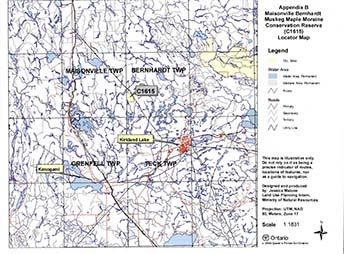
Enlarge Maisonville Bernhardt Muskeg Maple Moraine Conservation Reserve (C1615) Locator map
Appendix C: Wildlife Management Areas in C1615 map
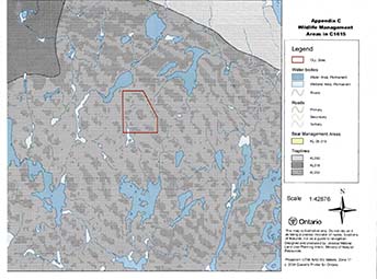
Enlarge Wildlife Management Areas in C1615 map
Appendix D: C1615 Wildlife areas map
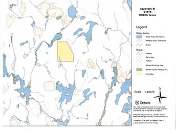
Enlarge C1615 Wildlife Areas map
Maisonville Bernhardt Muskeg Maple Moraine Conservation Reserve (C1615) Fact Sheet
September 2001
Background
On July 16, 1999, the Ontario Government released the Ontario’s Living Legacy Land Use Strategy to guide the planning and management of Crown lands in central and parts of northern Ontario. A major part of the Ontario’s Living Legacy Land Use Strategy was a government intent to establish 378 new protected areas. This commitment marks the biggest expansion of provincial parks and conservation reserves in Ontario’s history.
The Maisonville Bernhardt Muskeg Maple Moraine Conservation Reserve is part of the significant expansion of Ontario’s protected areas system. Following public and aboriginal consultation in the year 2000 on refining the boundary of this protected area, Ontario Regulation 805/94 of the Public Lands Act was amended on April 4, 2001, by Ontario Regulation 86/01, to formally establish this conservation reserve.
Size and location
The Masionville Bernhardt Muskeg Maple Moraine Conservation Reserve, consisting of 128 hectares of land. This site is found in Maisonville and Bernhardt Townships in the District of Timiskaming.
Area highlights
The representative features found here include three landform/vegetation types, open muskeg, medium aged red/silver maple and old birch on weakly broken ground moraine. Roadside exposure of volcanic rocks containing well formed pillows, and cut by a diabase dike with observable contact.
Land use intent
Conservation reserves are areas of Crown land set aside by regulation under the Public Lands Act.
Conservation reserves complement provincial parks in protecting representative natural areas and special landscapes. Most recreational; (e.g. hiking, skiing, tourism related uses, nature appreciation) and non-industrial (e.g. fur harvesting, commercial fishing and bait fishing) activities that have traditionally been enjoyed in the area will continue, provided that these uses do not impact on the natural features needing protection. Hunting and fishing are permitted within all new conservation reserves proposed through Ontario’s Living Legacy.
Commercial timber harvesting, mining, aggregate extraction and commercial hydroelectric development are prohibited in conservation reserves. Careful mining exploration may occur in specific conservation reserves proposed through Ontario’s Living Legacy, in areas that have provincially significant mineral potential. If a portion of a new conservation reserve is to be developed for a mine, it would be removed from the reserve, and appropriate replacement lands would be placed in regulation.
Next steps
In the future, the Ministry of Natural Resources will prepare a long-term management plan for this area. Depending upon the complexity of the issues within this conservation reserve, management planning may initially take the form of a simple Statement of Conservation Interest or a more detailed Resource Management Plan.
Planning, management and the uses permitted within the conservation reserve will be consistent with the commitments of the Ontario’s Living Legacy Land Use Strategy.
For more information
For further information on the proposed Masionville Bernhardt Muskeg Maple Moraine Conservation Reserve, please contact:
Eleanor Moro, District Planner
Ministry of Natural Resources
Kirkland Lake District
Tel: (705) 568-3244
Email: eleanor.moro@mnr.gov.on.ca
You may also visit the Ministry’s Internet website at www.ontarioslivinglegacy.com for information on Ontario’s Living Legacy.
Appendix 4: Procedural guideline 8 - Land uses - Test of compatibility (PL Procedure 3.03.05)
The Conservation Reserve policy provides broad direction with regard to the permitted uses. The policy provides only an indication of the variety of uses that will be considered acceptable in Conservation Reserves. The only caution is that “any new uses, and commercial activities associated with them, will be considered on a case by case basis and, they must pass a test of compatibility to be acceptable.”
What does a “test of compatibility” mean? An examination of this must start from the premise of why an area is set aside- specifically, its representative natural heritage values. Criteria are then identified to guide compatibility considerations. These criteria apply to the long-term acceptability of both existing uses and new uses.
-
Conformity to SCI/RMP: SCI describes values for which an area has been set aside and the range of appropriate uses that will be permitted in the area. SCI may also speak to the acceptability of other ’new’ uses currently not occurring in the area.
The first ’test’ is: “do proposed new land uses and/or commercial activities conform to the direction of the SCI/RMP for the Conservation Reserve? Would the new use(s) depart from the spirit of appropriate indicator land uses in the SCI/RMP?”
- Impact Assessment: If the proposed use(s) pass test 1 it is important to determine their impact on the area before they are approved. This should include the following:
- Impact on natural heritage values: "will the new use(s) impact any natural values in the area? If so, how and to what degree? Is it tolerable?
- Impact on cultural values: "will the new use(s) impact any historical or archaeological values in the area?
- Impact on research activities: “will the new use(s) affect research activities in the area?”
- Impact on current uses: “will the new use(s) have any negative impact on the array of current uses?”
- Impact on area administration: “will the new use(s) increase administrative cost and/or complexity?” (For example, the cost of area monitoring, security or enforcement).
- Impact on accommodating the use outside the Conservation Reserve: “Could the use(s) be accommodated as well or better outside the Conservation Reserve?”
- Impact on socio-economics of the area: “will the new use(s) affect the community (ies) surrounding the area in a positive or negative way?” (For example, will the new use make an area less remote thereby affecting a local tourism industry that is dependent on the area’s remoteness for its appeal?).
- Impact on area accessibility: “does the new use(s) give someone exclusive rights to the area or a portion of the area to the exclusion of other existing uses?”
Appendix 5: Procedural guideline C - Research activities in conservation reserves
Purpose
To encourage contributions to the goal of conservation reserves by:
- Providing direction for research activities associated with conservation reserves: and
- Establishing a process for the review and approval of proposals by researchers, which could have an impact on the values protected by the conservation reserve
Definition
Research means any investigation or study of the natural, cultural, social, economic, management or other features of characteristics of conservation reserves.
Guidelines
Research will be encouraged to provide a better understanding of the natural values protected by a conservation reserve and to advance their protection, planning and management. The Statement of Conservation Interest will define, for each conservation reserve, the key research issues, set out the parameters within which research may occur and identify research needs.
Applications and approvals
Researchers must apply in writing to the Area Supervisor for permission to conduct research. The request letter must contain a statement explaining why the proposed research should be undertaken in the particular conservation reserve in preference to another location.
Proposals will be reviewed and approved by the Area Supervisor, guided by the Statement of Conservation Interest prepared for each reserve (See Guideline AResource Management Planning) and using Guideline B - Land Uses - Test of Compatibility. Permission must be granted in writing, including any conditions to be met in conducting the research, prior to the undertaking of any research project.
Terms and conditions
Permission to conduct research under this policy will be valid for a period of 12 consecutive months from date of issue. Permission to continue a research project for additional periods of 12 months or less may be granted upon submission of a written request and progress report. The Ministry may require the posting of collateral to assure that the terms and conditions of granting permission are to be met.
The Area Supervisor may suspend or revoke permission at any time for failure on the part of the researcher to meet:
- The intent or conditions of this policy.
- The requirements under the Public Lands Act, including all amendments, where applicable.
- The requirements under any other Act or Regulations or Ontario or Canada, including those governing the taking, handling, storing, confining, trapping, excavating and marketing any specimen, artifact, information or action (for example, scientific collector’s permit).
- The conditions and agreements specified in granting permission.
Final report
The researcher will submit copies of reports, publications and theses following from the results of the project to the Area Supervisor.
Appendix 6: Crown land use atlas - Policy report
C1615
Masonville Bernhardt Muskeg Maple Moraine
Updated: January 15, 2004
Identification:
ID: C1615
Area Name: Masonville Bernhardt Muskeg Maple Moraine
Area (ha): 128
Designation: Conservation Reserve (Ontario’s Living Legacy)
MNR District(s): Kirkland Lake
Description:
The representative features found here include open muskeg, medium aged red/silver maple and old birch on weakly broken ground moraine.
Masonville Bernhardt Muskeg Maple Moraine was regulated as a conservation reserve on April 6, 2001.
Land use intent:
Management of this area is also governed by the general policies contained in the Land Use Strategy (1999).
Management direction:
Those uses and management activities not listed in the following table are governed by existing conservation reserve policy. Over time the management direction will be elaborated in a Statement of Conservation Interest or Resource Management Plan. Any new uses, and commercial activities associated with conservation reserves, will be considered on a case by case basis, and they must pass a test of compatibility to be acceptable. Compatibility is normally determined through a planning process.
Commercial activities
| Activity | Permitted | Guidelines |
|---|---|---|
| Aggregate extraction: | No | N/A |
| Bait fishing - Existing: | Yes | Existing use permitted to continue, unless there are significant demonstrated conflicts. |
| Bait fishing - New: | Maybe | New operations can be considered, subject to the “test of compatibility”. |
| Commercial fishing - Existing: | Yes | Existing use permitted to continue, unless there are significant demonstrated conflicts. |
| Commercial fishing - New: | Maybe | New operations can be considered, subject to the “test of compatibility”. |
| Commercial fur harvesting - Existing: | Yes | Existing use permitted to continue, unless there are significant demonstrated conflicts. Existing trap cabins can continue; new cabins are not permitted. |
| Commercial fur harvesting - New: | Maybe | New operations can be considered, subject to the “test of compatibility”. |
| Commercial hydro development: | No | N/A |
| Commercial timber harvest | No | N/A |
| Commercial tourism - Existing: | Yes | Existing authorized facilities can continue, unless there are significant demonstrated conflicts. |
| Commercial tourism - New: | Maybe | New tourism facilities can be considered during the planning for an individual reserve. |
| Bear hunting by nonresidents (guided) - Existing: | Yes | Existing authorized operations permitted to continue. |
| Bear hunting by nonresidents (guided) - New: | No | New operations not permitted. |
| Outfitting services existing: | Yes | Existing authorized operations permitted to continue. |
| Outfitting services - New: | Maybe | New operations can be considered during the planning for an individual reserve. |
| Outpost camps - Existing: | Yes | Existing authorized operations permitted to continue. |
| Outpost camps - New: | Maybe | New operations can be considered during the planning for an individual reserve. |
| Resorts/lodges - Existing: | Yes | Existing authorized operations permitted to continue. |
| Resorts/lodges - New: | Maybe | New tourism facilities can be considered during the planning for an individual reserve. |
| Energy transmission and communications corridors - Existing: | Yes | These facilities should avoid conservation reserve lands wherever possible. |
| Energy transmission and communications corridors - New: | No | N/A |
| Food harvesting (commercial) - Existing: | Maybe | N/A |
| Food harvesting (commercial) New: | Maybe | N/A |
| Mineral exploration and development: | No | N/A |
| Peat extraction: | No | N/A |
| Wild rice harvesting - Existing: | Yes | N/A |
| Wild rice harvesting - New: | Maybe | N/A |
Land and resource management activities
| Activity | Permitted | Guidelines |
|---|---|---|
| Crown land disposition - Private use: | Maybe | Sale of lands is not permitted, except for minor dispositions in support of existing uses (e.g., reconstruction of a septic system). Renewals of existing leases and land use permits are permitted. Requests for transfer of tenure will be considered in the context of the Statement of Conservation Interest or Resource Management Plan. New leases or land use permits permitted for approved activities. Tourism facilities can apply to upgrade tenure from LUP to lease. |
| Crown land disposition - Commercial use: | Maybe | Sale of lands is not permitted, except for minor dispositions in support of existing uses (e.g., reconstruction of a septic system). Renewals of existing leases and land use permits are permitted. Requests for transfer of tenure will be considered in the context of the Statement of Conservation Interest or Resource Management Plan. New leases or land use permits permitted for approved activities. Tourism facilities can apply to upgrade tenure from LUP to lease. |
| Fire suppression: | Yes | Fire suppression policies are similar to adjacent Crown lands, unless alternative fire policies have been developed through a planning process. |
| Fish habitat management: | Maybe | N/A |
| Fish stocking: | Maybe | Conservation Reserves policy indicates that “featured species management” may be permitted. |
| Insect/disease suppression: | Maybe | N/A |
| Inventory/monitoring | Yes | N/A |
| Prescribed burning: | Maybe | N/A |
| Roads (resource access) - Existing: | Yes | Existing roads can continue to be used. Continued use will include maintenance and may include future upgrading. |
| Roads (resource access) - New: | Maybe | New roads for resource extraction will not be permitted, with the exception of necessary access to existing forest reserves for mineral exploration and development. |
| Vegetation management: | Maybe | Conservation Reserves policy indicates that Featured Species Management and Natural Systems Management may be permitted. Vegetation management can be considered in a planning process. |
| Wildlife population management: | Maybe | N/A |
Science, education and heritage appreciation
| Activity | Permitted | Guidelines |
|---|---|---|
| Collecting: | No | N/A |
| Historical appreciation: | Yes | N/A |
| Nature appreciation: | Yes | N/A |
| Photography and painting: | Yes | N/A |
| Research: | Yes | N/A |
| Wildlife viewing: | Yes | N/A |
Recreation activities and facilities
| Activity | Permitted | Guidelines |
|---|---|---|
| All-terrain vehicle use - On Trails: | Yes | Existing use permitted to continue where it does not adversely affect the values being protected. |
| All-terrain vehicle use - Off trails: | No | ATV use not permitted except for direct retrieval of game. |
| Campgrounds: | Maybe | N/A |
| Food gathering | Yes | N/A |
| Horseback riding (trail): | Yes | Existing use on trails permitted. |
| Hunting: | Yes | N/A |
| Mountain bike use: | Yes | Existing use on trails permitted. |
| Motor boat use - Commercial: | Yes | N/A |
| Motor boat use - Private: | Yes | N/A |
| Non-motorized recreation travel: | Yes | N/A |
| Private recreation camps (hunt camps) - Existing: | Yes | Existing camps permitted to continue, and may be eligible for enhanced tenure, but not purchase of land. |
| Private recreation camps (hunt camps) - New: | No | N/A |
| Rock climbing: | Maybe | N/A |
| Snowmobiling on trails: | Yes | Except for the direct retrieval of game. |
| Snowmobiling off trails: | No | N/A |
| Sport fishing: | Yes | N/A |
| Trail development - Existing | Yes | N/A |
| Trail development - New | Maybe | Development of trails for a variety of activities (e.g., hiking, cross-country skiing, cycling, horseback riding, snowmobiling) can be considered as part of planning for an individual reserve. |
Note: The policies outlined in this table do not supersede any Aboriginal or treaty rights that may exist, or other legal obligations.
Management of this conservation reserve is carried out within the context of Conservation Reserve policy as amended by the policies for new conservation reserves outlined in the Ontario’s Living Legacy Land Use Strategy.
Source of direction:
Ontario’s Living Legacy Land Use Strategy (1999)
Conservation Reserves Policy (1997)
Explanation of edits:
Appendix 7: Locator map
Figure 1: Masonville Bernhardt Muskeg Maple Moraine Conservation Reserve (C1615) Locator map
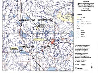
Enlarge Figure 1: Masonville Bernhardt Muskeg Maple Moraine Conservation Reserve (C1615) Locator map
Appendix 8: Natural heritage - Life sciences checksheet
- Name: Masonville Bernhardt Muskeg Maple Moraine
- Map name: Kirkland Lake
- Map number: 42A/1
- UTM reference: 564534
- Locality: Timiskaming
- Latitude: 48 12’57"N
- Longitude: 80 08’23"W
- NAD: 83 CNT
- Minimum Altitude: 340 m
- Maximum Altitude: 400 m
- Township: Bernhardt
- Area: 128 ha
- Ownership: Crown
- MNR Region: Northeast
- MNR District: Kirkland Lake
- Ecoregion and Ecodistrict: 3E-6 (Hills, 1959 & Crins, 2000)
- Landform unit(s): 9 - Organic Deposits, 2ad -Bedrock-Drift Complex; cover predominantly till, thin, but relatively continuous, 2ac -Bedrock-Drift Complex; cover predominantly till, discontinuous
- Aerial photographs (Year-Roll-Flight Line-Numbers): 1986-4808-02-65
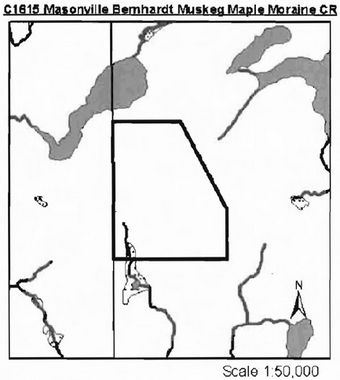
Map of C1615 Masonville Bernhardt Muskeg Maple Moraine CR
Physical and biological features
The Masonville Bernhardt Muskeg Maple Moraine CR is located in Bernhardt Township within the town limits of Kirkland Lake and approximately 10 km from the downtown core. The reserve is 128 hectares in size, comprised mostly of deciduous mixedwood forest stands with some conifer around the edge. Access is by aircraft or by ATV using the hydro line along the east border. The whole site is vectored with most of the east border following a utility corridor and the west border following the Maissonville/Bernhardt township line.
The reserve is located in the Lake Abitibi Ecoregion, Kirkland Lake Ecodistrict 3E-6 (Hills, 1959; Crins, 2000). The forest climate for Ecoregion 3E is mid-humid and mid-boreal. The Ecoregion is characterized by stands of spruce, fir, poplar and birch on fresh sites of moderately sloping terrain. White and red pine may be found on sand ridges. American elm and white cedar are found only in protected valleys. The Kirkland Lake Ecodistrict is characterized by moderately broken plains of granitic and low-base bedrock with a thin cover of granitic and low-based sand and siltysand. Several trains of glaciofluvial sand and gravel occur (Hills, 1959).
C1615 is situated in the Abitibi Upland section of the James Physiographic Region. This region contains broad rolling surfaces that reach about 1500 feet near its southern borders and is underlain by crystalline Archean rocks (Bostock, 1970).
According to Rowe (1972), the reserve is situated in the Missinaibi-Cabonga (B.7) section of the Boreal Forest Region. The predominant forest is mixed with balsam fir, black spruce and white birch with scattered white spruce and trembling aspen. With dieback of white birch and spruce budworm infestation of balsam fir, vast areas of open, snag-filled (mountain maple, hazel, etc.) forests have resulted. White and red pine are encountered on rocky shores and ridges, jack pine on sand terraces along rivers, black spruce with tamarack on large areas of wet organic soils and eastern white cedar with black spruce on other lowlands. The topography is generally rolling with numerous flats along rivers and lakesides.
Gap analysis for site district 3E6 (Candidate 18), indicates the site contains open muskeg, medium aged red/silver maple and old white birch on weakly broken ground moraine (Ritchie & Thompson, 1998). The FRI was classified using an ecological approach based on Taylor et al with some modifications. Ms mixedwood
The provincial landform coverage (OFRI) classifies the entire site as weakly broken ground moraine (Map 1b). Rik Kristjansson, through aerial reconnaissance, surficial geology map review and aerial photograph interpretation classifies the area as Bedrock-Drift complex with the eastern portion of the site with the drift cover predominantly till, thin but relatively continuous and the western portion of the site to be predominantly till, discontinuous (Map 1a) (Kristjannson, 2002)
One Bear Management Area (BMA) is found in the site as well as one active trapline (Map 3a). Hunting and trapping are popular in the area. A number of moose stands were observed on trails around the conservation reserve (Scott, 2002). A snowmobile trail runs along the hydro corridor. The conservation reserve is situated in tertiary watershed 2JC in the Ottawa River Basin.
Condition
Condition is the amount of disturbance, man-made or natural, within a conservation reserve. In C1615, the amount of disturbance is rated as moderate. Forest harvesting of jack pine, white birch and black spruce has occurred in the northwest corner and in part of the south section during the 1996/97 AWS (annual work schedule) (Ritchie & Thompson, 1998). The dead white birch along the southern border of the conservation reserve indicates chemical tending has occurred in the site. The hydro line corridor along the east border is another man-made disturbance, making this site more readily accessible in the future. No natural disturbance was visible.
Diversity
Diversity is a measure of the site’s life and earth science heterogeneity. It is based on the number and range (variety) of the natural landscape features and landforms of earth science values and the richness and evenness of the life science component. Through analysis of the FRI data and Kristjansson’s (2003) interpretation of the surficial geology there are nineteen (19) landform:vegetation combinations based on standard forest unit and twenty (20) based on forest community. This number was modified to accommodate the difference in organic area boundaries between FRI and air photo interpretation of surficial geology. The diversity of the site is further reduced due to the fractured communities around the perimeter of the site. The following forest communities are less than five (5) hectares and occur in thinner bands around the perimeter; Pj predominant conifer, Po mixedwood and Sb dominant conifer. Landform:vegetation combinations considered for this conservation reserve are thirteen (13) based on forest community and eleven (11) based on standard forest unit. The evenness of this representation is strongly skewed as the two dominant forest communities make up over 65% of the total site area (Area Summary Tables, Appendix 2). Developmental stage does not have an effect on the diversity of this site as it is fairly even aged. A diversity rating of low has been assigned based on the above information.
Ecological considerations
Wherever possible, a site’s boundaries should be created to include the greatest diversity of life and earth science features to provide the maximum ecological integrity. It should be ecologically self-contained, bounded by natural features and include adequate area to buffer the core ecosystems from adjacent land use activities (OMNR, 1992).
Currently we do not have minimum size standards for conservation reserves under different landscape conditions. However, a minimum size standard of 2000 ha has been established for natural environment parks by Ontario Parks (OMNR, 1992). This minimum standard was considered necessary to protect representative landscapes as well as allow for low intensity recreational activities. At 128 ha in size this conservation reserve falls well below this minimum criteria.
The conservation reserve consists entirely of vectored boundaries. The northeast border follows a hydro corridor while the western border follows the Maisonville/Bernhardt township line. The north, south and southeast borders do not follow any such feature. This can make it difficult to definitively mark the boundary of the conservation reserve. Historically, the UTM Blue Line boundary (History map, Appendix 1) followed specific forest stands, extended to Wendtwright Lake in the north and surrounded a small lake in the south. While it is more desirable for boundaries to follow natural and cultural features, the vectored border of this conservation reserve provide some protection to the forest communities found within the site. The smaller, fractured forest communities along the site perimeter have been harvested in the past. Care should be taken to ensure the integrity of the regeneration of these areas to further protect the core communities within the conservation reserve.
Special features
The maple mixedwood stands found within the conservation reserve are considered the special attraction of this site due to their aesthetic quality.
Major information sources
Bostock, H.S., 1970. Geology and economic minerals of Canada - Part A
Crins, W.J. 2000. Ecoregions of Ontario: Modifications to Angus Hills’ Site Regions and Site Districts revisions and rationale.
Hills, G.A. 1959. A ready reference to the description of the land of Ontario and its productivity.
Kristjansson, R. 2003. Draft earth science inventory checklist: Masonville Bernhardt Muskeg Maple Moraine (C1615). Ontario Ministry of Natural Resources.
Ontario Ministry of Natural Resources. 1992. Ontario Provincial Parks: Planning and Management Policies, 1992 Update.
Ontario Ministry of Natural Resources. 1999. Ontario’s Living Legacy Land Use Strategy, Queens Printer for Ontario, Toronto, ON. 136p.
Ontario Ministry of Natural Resources. 2002. MNR districts and major basins of Ontario.
Poser, S. 1992. Report of the status of provincial parks in the site region and districts of Ontario. Ontario Ministry of Natural Resources Report.
Scott, Mark. 2002. Masonville Bernhardt Muskeg Maple Moraine (C1615) Recreational Checksheet, Draft OMNR Report
Rowe, J.S. 1972. Forest regions of Canada. Dept. of Fisheries and the Environment. Canadian Forestry Service. Publ. No. 1300. 172 pp.
Taylor, K.C., R.W. Arnupd B.G. Merchant, W.J. Parton and J. Nieppola. 2000. A field guide to forest ecosystems of northeastern Ontario. 2nd Edition. Northeast Science and Technology NEST Field Guide FG-001.
Uhlig, P., A Harris, G. Craig, C. Bowling, B. Chambers, B. Naylor and G. Beemer. 2001. Old growth forest definitions for Ontario. Ont. Ministry of Natural Resources, Queen’s Printer for Ontario, Toronto, ON. 27p.
Significance level (provincial/regional/local) and Brief summary of major representative values
The OLL Land Use Strategy describes the representative features of this conservation reserve to be open muskeg, medium aged red/silver maple and old birch on weakly broken ground moraine. The UTM Blue Line Boundary captured these maple mixedwood stands by following the stand boundaries. The current boundary provides some protection for these communities.
Sensitivity
The maple mixedwood stands are the most sensitive feature of the conservation reserve due to possible future encroachment if the vectored boundaries are not clearly marked.
Recommendations
- This fourth step checksheet should be advanced to a fifth step by comparing the fourth step checksheet with the current provincial landform layers based on the new regulated boundary. This would show the comparisons that can be made between the above local analysis and the provincially run analysis and would determine more fully the site’s significance and contribution to the parks and protected areas program.
- The vectored defined boundaries for the site should be to ensure that the values within the site are protected from surrounding land use activities. Further analysis and assessment may require additional management prescription to ensure long-term protection of the site’s natural heritage values.
- Any future economic or development proposals should go through a Test of Compatibility to ensure the natural heritage features are well protected. For example, any future trail development must consider the values found within the boundaries of the site, the rationale for developing trails within the site and the availability of current access through the site and surrounding areas. Furthermore, any new trail development will require a ’Test of Compatibility’. Sensitive areas previously discussed should be avoided.
- Overall custodial management is the responsibility of the district office with support from the regional natural heritage specialist and Ontario Parks. To advance conservation reserve custodial management, future managers will need to monitor the current state of the CRs resources at least at the community and landscape levels within and adjacent to the conservation reserve and its surrounding environment. Such monitoring could include: evaluating and reporting on changes such as; natural disturbances (i.e. fire, insect/disease, wind throw, etc.), human disturbances (i.e. forest harvesting, access and/or other land use activities) as well as management prescriptions (i.e. rehabilitation efforts and/or vegetative management planning).
- Ongoing evaluations and reports will have to rely on current and new technologies such as satellite imagery, global positioning systems (GPS), supplementary aerial photography (SAP) and/or aerial/ground reconnaissance surveys/assessments conducted periodically and placed within a GIS database. Such tools could help managers spatially record areas affected, severity of perturbations or management action as well as consider the sensitivity of values, the design of CR and determine the future desired condition of the site. Monitoring efficiencies could be enhanced via partnerships and internal coordination within MNR
footnote 5 .
Time Effort Spent on Site:
September 16, 2002 11:55am - 12:15pm
Date Compiled:
Compiler(s):
Lori King, Barb Burkhardt and Sean Longyear
Date Reviewed:
Reviewer:
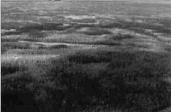
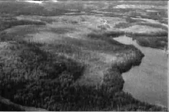
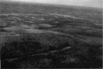
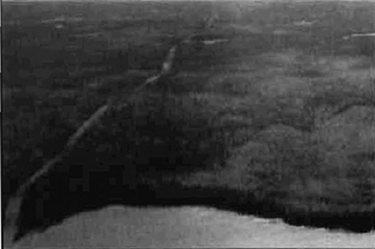
Map 1a: Surficial geology
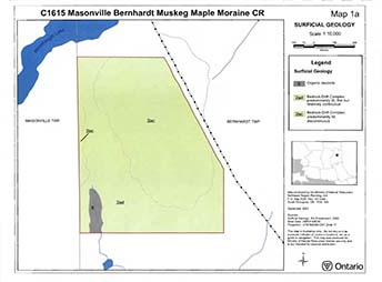
Enlarge Map 1a: Surficial Geology
Map 1b: Landforms
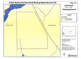
Map 2a: Forest communities
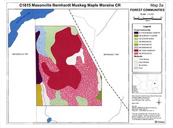
Enlarge Map 2a: Forest Communities
Map 2b: Stocking distribution
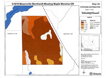
Enlarge Map 2b: Stocking Distribution
Map 2c: Age Distribution
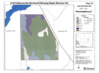
Enlarge Map 2c: Age Distribution
Map 3a: Values
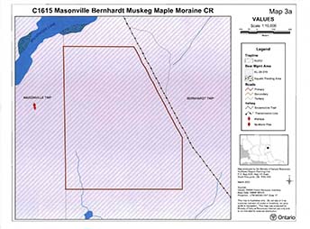
Map 3b: Wetlands
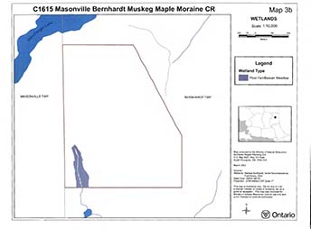
Map 5: Old growth
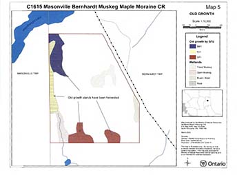
Appendix 9: Earth science checksheet
Maisonville Bernhardt Muskeg Maple Moraine
Conservation Reserve (Cl615)
Approved Earth Science Checksheet
Kirkland Lake
July 29, 2004
Prepared by: F.J. (Rik) Kristjansson
Earth science inventory checklist
- Name: Maisonville Bernhardt Muskeg Maple Moraine C1615
- Map Name: Kirkland Lake
- NTS Number: 42A/1
- UTM Ref. (Datum): 564534
- Latitude: 48°12′57″ N
- Longitude: 80°08′23″ W
- Elevation (Min): 340 m
- Elevation (Max): 400 m
- Locality: Timiskaming
- Township: Bernhardt
- Area (ha): 128 ha
- MNR District: Kirkland Lake
- MNR Region: Northeast
- Aerial Photographs: 86-02, 4808, 64 to 66
Prepared by: FJ. (Rik) Kristjansson, Consulting Geoscientist
Reviewed by: Phil Kor, Senior Conservation Geologist
Date: July 29, 2004
Earth science features
Bedrock geology:
Based on Map 2543 (Ontario Geological Survey, 1991), the northwest portion (approximately 1/3) of the Maisonville Bernhardt Muskeg Maple Moraine Conservation Reserve appears to be underlain by mafic to intermediate metavolcanic rocks of the Superior Provi nce, Precambrian Shield. The southeast portion (approximately 2/3) of the conservation reserve, in contrast, is underlain by intermediate intrusive rocks of the Superior Province. The latter rocks are referred to as a dioritemonzonite-granodiorite suite. The geological boundary between the indicated bedrock units generally subdivides the conservation reserve along a NE-SW trend.
Surficial geology:
Based on a brief helicopter reconnaissance survey, review of terrain geological mapping (Lee, 1979, Data Base Map 5030), review of surficial geological mapping (Baker, 1980, Map P.2382), and interpretation of available aerial photography (1986), the Maisonville Bernhardt Muskeg Maple Moraine Conservation Reserve appears to be immediately underlain by areas of Bedrock-Drift Complex (Units 2ac and 2ad) and Organic Deposits (Unit 9). Please refer to the attached aerial photographic interpretation for the occurrence and distribution of these surficial geological units within the conservation reserve (Appendix A).
Bedrock-Drift Complex, including eastern and western areas of Unit 2ac and an intervening area of Unit 2ad, dominates the surficial geology of this conservation reserve. The eastern area of Unit 2ac immediately underlies all of the northeast quadrant, much of the southeast quadrant, and parts of both northwest and southwest quadrants, while the western area of Unit 2ac immediately underlies the extreme central west part of the conservation reserve. Moderate bedrock exposure associated with a discontinuous cover of till is anticipated within these eastern and western areas of bedrock-drift complex. The associated cover of till probably consists of gravelly, silty sand till (Baker, 1980, Map P.2382). The intervening area of Unit 2ad immediately underlies part of the northwest quadrant, most of the southwest quadrant, and part of the southeast quadrant of the conservation reserve. Minor bedrock exposure associated with a thin, relatively continuous cover of till is expected within this intervening area of bedrock-drift complex. As indicated above, the associated cover of till very likely is composed of gravelly, silty sand till. Finally, a small area of Organic Deposits (Unit 9) has been partially encompassed by the southwest quadrant of the conservation reserve. Photo. C1615-01 provides a general view of the conservation reserve.
Significance:
The geological features described above are commonly encountered throughout this region, and are considered to be of only local significance.
Sensitivity:
Considering the relatively passive land uses anticipated within a conservation reserve (e.g., hunting), the various geological features are considered to have low sensitivity.
Recommendations:
None
References:
Baker, C.L., 1980; Quaternary Geology of the Kirkland Lake Area, District of Timiskaming; Map P.2382, Geological Series, Preliminary Map, Scale 1:50,000. Geology 1978 and 1979.
Lee, H. A., 1979; Northern Ontario Engineering Geology Terrain Study, Data Base Map, Kirkland Lake; Ontario Geological Survey, Map 5030, Scale 1:100,000.
Ontario Geological Survey, 1991; Bedrock Geology of Ontario, East-Central Sheet; Ontario Geological Survey, Map 2543, Scale 1:1,000,000.
Appendix A: Preliminary surficial geology of the Maisonville Bernhardt Muskeg Maple Moraine Conservation Reserve (C1615)
Photographs
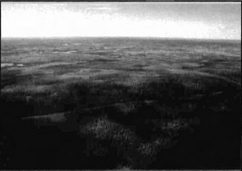
Photo. C1615-01
Provides a general view of the conservation reserve. The south half of Wendtwright Lake, located a short distance northwest and west of the northwest quadrant of the conservation reserve, is apparent in the extreme centre right of the photograph. The view is approximately west.
Footnotes
- footnote[1] Back to paragraph Vector - A straight line in space characterized mathematically by its direction and magnitude. It is used in GIS work to create a file of points such that vectors can be drawn from point to point to portray line segments.
- footnote[2] Back to paragraph Mixedwoods are defined as follows: hardwood mixedwoods are stands dominated by hardwoods with less than 30% cover of conifer in the main canopy; similarly conifer mixedwoods contain less than 30% hardwoods in the canopy. Mixedwoods contain approximately equal percentages of conifer and hardwood trees and true mixedwoods contain a 50:50 split between conifers and hardwoods (modified after Taylor et al 2000).
- footnote[3] Back to paragraph Conifer stands are defined as follows: pure conifer stands contain 100% conifer trees in the canopy; dominant conifer stands contain less than 10% cover of hardwoods in the main canopy and predominant conifer stands contain less than 20% cover of hardwoods in the main canopy. Similarly hardwood stands may contain no conifer in canopy (pure hardwood), less than 10% conifer (dominant hardwood) or less than 20% conifer cover (predominant hardwood) (modified after Taylor et al 2000).
- footnote[4] Back to paragraph Wetlands were classified after Arnup et al. 1999 and Harris et al, 1996
- footnote[5] Back to paragraph Coordination could include a variety of expertise from the following: Field Services Division, Ontario Parks, Aviation and Forest Fire Management Branch, Forest Health and Silvicultural and Forest Management Planning Sections, Northeast Science and Information etc. Additional expertise within and outside the MNR could be sought as required.