McDougal Point Peninsula Conservation Reserve Management Statement
This document provides policy direction for the protection, development and management of the McDougal Point Peninsula Conservation Reserve and its resources.
November 2004
Kirkland Lake District
Ministry of Natural Resources
Approval statement
I am pleased to approve this Statement of Conservation Interest (SCI) for the MacDougal Point Peninsula Conservation Reserve (C1714).
Direction for establishing, planning and managing conservation reserves is defined under the Public Lands Act, Crown Land Use Policy Atlas and current policy. “Ontario’s network of natural heritage areas has been established to protect and conserve areas representative of the diversity of the natural regions of the province, including species, habitats, features, and ecological systems which comprise that natural diversity.” (Policy PL 3.03.05, MNR 1997).
This basic SCI will provide guidance for the management of MacDougal Point Peninsula Conservation Reserve and the basis for the ongoing monitoring of activities. Program specialists within Kirkland Lake District provided detailed input during the formulation of this SCI document. More detailed direction at this time is not anticipated. Should significant facility development be considered or complex issues arise requiring additional studies, more defined management direction, or special protection measures, a more detailed Conservation Reserve Management Plan will be prepared with full public consultation.
Public and Aboriginal consultation occurred regarding this site prior to its regulation during the planning for Ontario’s Living Legacy (MNR, 1999). Furthermore, the public, aboriginals and other interested parties were notified during a 30 day period beginning in January 2005 concerning a draft of this SCI. Comments from the notification period have been considered in the development of this document.
The conservation reserve will be managed under the jurisdiction of the Elk Lake/Matheson Area Supervisor of the Ministry of Natural Resources, Kirkland Lake District.
Plan authors:
Rick Gordon Ontario’s Living Legacy Resource Manager
Jody Bissett Land Use Planner
Kirkland Lake District
Approved by:
Corrinne Nelson, District Manager
Date: March 24, 2005
Rob Galloway, Regional Director
Date: April 24, 2005
1.0 Introduction
Ontario’s network of natural heritage areas has been established to protect and conserve areas representative of the diversity of the natural regions of the province, including species, habitats, features and ecological systems which comprise that natural diversity. Protected natural heritage areas are a key component in sustainable management of natural resources. They ensure that representative sites within the larger sustainably managed landscape are permanently retained in their natural state.
Natural Heritage areas are considered to be sensitive, requiring protection from incompatible activities if their values are to endure over time. The Ministry of Natural Resources (MNR) has established conservation reserves as a new tool to offer protection for these areas on public lands, while permitting many traditional public lands uses to continue. Such uses include the traditional activities of Aboriginal Peoples.
Ontario’s Living Legacy Land Use Strategy (OLL LUS) (MNR, 1999) and the Crown Land Use Atlas set the direction for the administration and management of parks and protected areas on Crown lands within three planning regions; the Boreal West, Boreal East and Great Lakes-St. Lawrence areas. This strategy’s natural heritage objectives include protection of natural and cultural heritage values and the provision of opportunities for outdoor recreation, heritage appreciation and tourism (MNR, 1999).
Protected areas designated within the OLL LUS have been selected based on their representation of the spectrum of the province’s ecosystems and natural features including both biological and geological features, while minimizing impacts on other land uses. Representation was described using landform and vegetation combinations based on Hill’s (1959) site district concept.
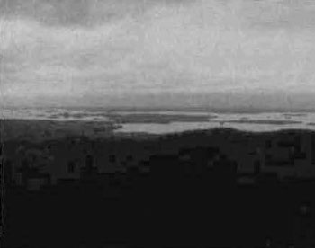
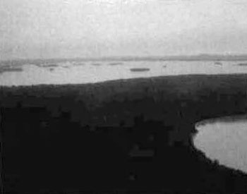
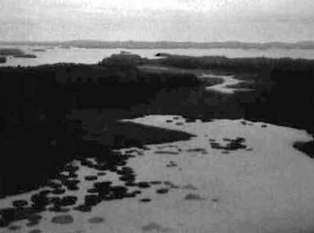
The MacDougal Point Peninsula Conservation Reserve (MPPCR) is located approximately 65 km northeast of the Town of Kirkland Lake and 45 km east of the Town of Iroquois Falls (Locator Map, Appendix 7). The Conservation Reserve is found within Rand, Frecheville and Stoughton Townships in Kirkland Lake MNR District and in an unnamed Township in Cochrane MNR District, with Kirkland Lake MNR assuming responsibility for the site. The site is made up of six separate blocks situated along the shores of Lake Abitibi and occupies an area of 6,035 hectares. The sites can be accessed by boat from Lake Abitibi or by several forestry roads/trails. The six blocks representing the MacDougal Point Peninsula Conservation Reserve are as follows MacDougal Point, the Narrows, Swampy Creek, Lightning Point, Okikodosik Narrows and Teddy Bear Marsh, all are found around the southern shores of Lake Abitibi (Figure 1.0).
SCI documents are the minimum level of management direction established for any conservation reserve and generally are brief management plans. This SCI will govern the lands and waters within the regulated boundary of the MacDougal Point Peninsula Conservation Reserve. However, to ensure MNR protection objectives are being fully met within the conservation reserve, the surrounding landscape and related activities should consider the site’s objectives and heritage values. In addition, it is the intent of the SCI to create public awareness that will promote responsible stewardship of protected areas and surrounding lands, with management partners such as Ontario Parks, industry and local governments. MNR District staff will pursue and advance sound environmental, economic and social strategies and policies related to the protection of conservation reserves and provincial parks.
The purpose of this SCI is to identify and describe the values of MacDougal Point Peninsula Conservation Reserve and outline the Ministry’s management intent for the conservation reserve. The management direction will protect the site’s natural heritage values and demonstrate its compatibility within the larger sustainable landscape. This direction will comply with land use intent as stated by the OLL Land Use Strategy (MNR, 1999).
Figure 1.0:
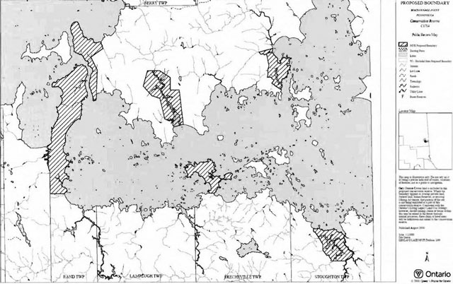
The six MacDougal Point Peninsula Conservation Reserve areas. From West to East - MacDougal Point, the Narrows, Swampy Creek, Lightning Point, Okikodosik Narrows and Teddy Bear Marsh.
2.0 Goals and objectives
2.1 Goal of statement of conservation interest
The goal of this SCI is to describe and protect natural heritage values on public lands while permitting compatible land use strategies.
2.2 Objectives of SCI
2.2.1 Short term objectives
The short-term objectives are to identify the State of Resource with respect to natural heritage values and current land use activities for the MacDougal Point Peninsula Conservation Reserve. A priority will be placed on the protection of the site’s natural values via specific guidelines, strategies and prescriptions detailed in this plan. Finally, legislated planning requirements will be met, in particular a SCI will be developed within three years of regulation.
2.2.2 Long term objectives
The long-term objectives will be to establish representative targets (e.g. future forest conditions) and validate the site as a potential scientific benchmark. To ensure protection of natural and cultural heritage features and values, this SCI will establish an evaluation process to address future new uses and commercial activities associated with them (e.g. Test of Compatibility Procedural Guideline B in Conservation Reserve Policy PL 3.03.05). Finally, this SCI will identify research/client services and marketing strategies and give direction to evaluate future new uses or economic ventures.
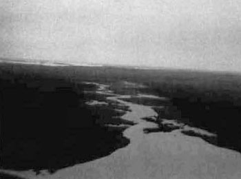
Figure 2.0
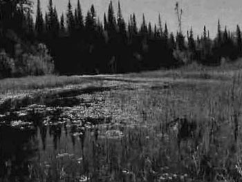
Site: MacDougal Point Peninsula CR
Location: Teddy Bear Marsh
Ground Recreation Inventory
September 05, 2003
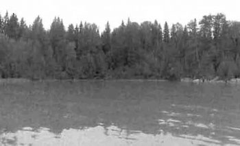
Picture by Rick Gordon
Picture location was from a boat cache on an inlet stream north west of Teddy Bear Marsh. View of a healthy marsh river system surrounded by mixed spruce forest.
3.0 Management planning
3.1 Planning area
The planning area for this site will consist of the area within the regulated boundary for the MacDougal Point Peninsula Conservation Reserve (History Map, Appendix #8), (Regulation Maps, Appendix #9). This land base will form the area directly influenced by this SCI. The SCI will recognize the protection of values within the planning area; however, to fully protect values within the conservation reserve, the lands beyond the regulated boundary may require additional consideration within larger land use or resource management plans. Nevertheless, any strategies noted within this plan related to the site’s boundary or beyond will need to be presented for consideration within a larger planning context.
3.2 Management planning context
The MacDougal Point Peninsula Conservation Reserve was first designated as a candidate conservation reserve by MNR in the OLL Proposed Land Use Strategy (SFL) land base (Iroquois Falls Forest).
The regulation of this conservation reserve will prohibit the following commercial activities; commercial forest harvest, peat/aggregate extraction, mining or hydroelectric power development (MNR, 1999). Traditional activities within this reserve may continue such as fishing, hunting, existing bear management, baitfish and trapping. This SCI document and future management will continue to resolve conflicts regarding incompatibility between uses and to ensure that identified values are adequately protected.
At present, there is no land within the CR boundaries that is under land tenure. In the future, land within the conservation reserve will not be sold or leased. New uses and potential commercial activities may be acceptable if they do not impact the natural heritage values of the site. This SCI will only address known issues or current proposals with respect to permitted uses or potential economic opportunities brought forward to the District Manager during this planning stage. However, in terms of approving future permitted uses and/or development(s), there are established mechanisms in place to address such proposals. Any future proposals will be reviewed using the Procedural Guideline B - Land Uses Test of Compatibility Public Lands Act Policy PL 3.03.05 (MNR, 1997) (Appendix #4) or other standard MNR environmental screening processes.
Consideration of proposals pertaining to cultural resources may be screened through Conserving a Future for our Past: Archaeology, Land Use Planning & Development in Ontario, Section 3 (MCzCR, 1997), or in processes such as that used by MNR to establish Area of Concern (AOC) descriptions and prescriptions for cultural heritage resources within forest management plans (FMPs).
These planning tools will help refine the review process once the proposal satisfies the direction and intent of the Public Lands Act, associated policies and this planning document.
Fish and wildlife management activities will generally occur in a manner similar to surrounding Crown lands.
Fire Management is described in Section 6.2.
Specific land and resource use is described in Section 5.
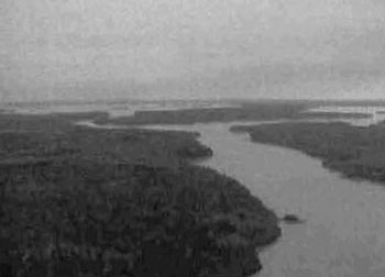
Figure 3.0
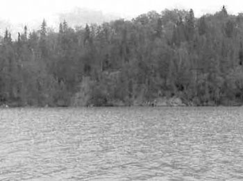
Site: MacDougal Point Peninsula CR
Location: Narrows
Ground Recreation Inventory
August 06, 2003
Picture by Rick Gordon
Narrows between north and south basins of Lake Abitibi looking northeast. View of bedrock-controlled ridge in Narrows block with spruce mixed wood forest cover.
3.3 Planning process
Once a conservation reserve is passed into regulation, the level of management planning required to fulfill the protection targets must be determined. There are two policy documents involved. The first is the Statement of Conservation Interest (RMP), which deals with more complex issues where several conflicting demands are placed on the resources. The guidelines for the preparation of these documents are outlined in Procedural Guideline A - Resource Management Planning (Conservation Reserves Procedure PL 3.03.05 Public Lands Act). The appropriate plan must be completed within three years of the regulation date.
A basic Statement of Conservation Interest (SCI) is the form of management for this Conservation Reserve. Interested parties from both the private and public sector were consulted during the OLL planning process from candidate conservation reserve to regulation. The public was widely consulted during the regulation process and further consultation is not required at this time. In addition, a public notification of a draft of this SCI document occurred for a period of 30 days beginning in January 2005 (Appendix #2). The intent of this SCI is to fulfil the commitments made within the OLL LUS (MNR, 1999).
The revised SCI was reviewed by the Kirkland Lake District Manager (DM). Upon approval by the DM the SCI was presented to the Regional Director (RD) for final approval.
Following RD approval, interested public, user groups and shareholders were notified that the Statement of Conservation Interest for the MacDougal Point Peninsula Conservation Reserve was approved.
Public consultation will be solicited as part of any future reviews of land use proposals that would require new decisions to be made. In addition, any new, significant management direction considered will be published on the Environmental Bill of Rights Registry (EBR).
The SCI is a planning document that will provide background information, identify values to be protected and establish management guidelines for use in the administration of the reserve.
The implementation of the SCI will be the mandate of the MNR at the District level; however, associations with various partners may be sought to assist in the delivery. This SCI is a working document, and as a result, it may be necessary to make revisions to it from time to time.
4.0 Background information
4.1 Location and site description
4.1.1 Location
The following table describes the location and provides administrative details of the MacDougal Point Peninsula Conservation Reserve:
Table 1.0: Location data and administrative details
[Table 1.0 converted to a list]
- Name: MacDougal Point Peninsula Conservation Reserve
- Ecoregion - ecodistrict (Hills): Lake Abitibi Eco Region 3E-6
- MNR administrative region/district area: Northeast Region/Kirkland Lake District in the Elk Lake/Matheson Area
- Total area: 6035 ha
-
UTM coordinates:
Location NAD 83, Zone 17
MacDougal Point - 579226m E, 5395499m N
The Narrows - 581182m E, 5401431m N
Swampy Creek - 588973m E, 5396853m N
Okikodosik Narrows - 599940m E, 5399252m N
TBM - 605494m E, 5382312m N
Lightning PT - 592689m E, 5389534m N - Nearest town/municipality: 65 km Northeast of Kirkland Lake/45 km East of Matheson/45 km East of Iroquois Falls Township(s) Rand, Frecheville, Stoughton Townships within Kirkland Lake MNR District & an unnamed Township in Cochrane MNR District
- OBM numbers: 570053900, 580053900, 580054000, 590053800, 590053900, 600053800
-
Topographical map name/number:
Lightning River 32 D/12
Aylen River 32 D/13 - Wildlife management unit: WMU 27 & WMU 28
- Forest management unit: Iroquois Falls Forest
4.1.2 Site description
4.1.2.1. Physical description
The MacDougal Point Peninsula Conservation Reserve is located approximately 65 km northeast of the Town of Kirkland Lake and 45 km east of the Town of Iroquois Falls. The Conservation Reserve is found within Rand, Frecheville and Stoughton Townships in Kirkland Lake MNR District and in an unnamed Township in Cochrane MNR District. The site is made up of 6 blocks separated by land and Lake Abitibi and occupies an area of 6,035 hectares (locator map, Appendix #7). The six blocks representing the MacDougal Point Peninsula Conservation Reserve are as follows; MacDougal Point, the Narrows, Swampy Creek, Lightning Point, Okikodosik Narrows and Teddy Bear Marsh. All of these sites are located around the southern portion of Lake Abitibi (Figure 1.0).
The Conservation Reserve was originally in the Hill’s site (1959) districts (Lake Abitibi Eco Region) of 3E-3 (Cochrane) and 3E-6 (Kirkland Lake). However with the new boundary interpretation brought in by Grins et al. (2000), the Conservation Reserve is now entirely in Ecodistrict 3E-6. The site region or Eco Region is characterized by moderately to gently rolling bedrock, generally covered by deep deposits of clay, silt and sand with locally extensive peatlands and wetlands. Regional vegetation includes good stands of spruce, poplar and birch on fresh sites with moderately sloping terrain, white and red pine on sand ridges and American elm and white cedar in protected areas. Grey wooded soils and brown wooded soils are common on well-drained portions of limy clay and silt plains with peat and peat-gley soils occupying over 80% of these areas. Weakly developed boreal brown wooded and podsols are common on the deep sands and rocky areas covered with light textured materials. Forest climate type is mid-humid, mid-boreal (Hills 1959; Poser 1992).
Physiographically Lake Abitibi is situated in a large plain of fine-grained sediments interpreted to represent glaciolacustrine and lacustrine deposition in the Abitibi basin from early postglacial time to the present (Map 1b, Appendix #8). The basin formed part of the Barlow-Ojibway and Ojibway stages of glacial lakes following glacial retreat from the area some 10,000 years ago. Sedimentation into the basin continues to this day, evidenced by the muddy appearance of the lake waters. The sediments in the basin consist primarily of silt and clay, notably as rhythmites and/or varves. These are the most prevalent surficial sediments in all six portions of C1714, forming a thin veneer over bedrock topography and thicker deposits in intervening lowland areas.
MacDougal Point Peninsula CR constitutes six (6) portions of the mainland around the central basin of Lake Abitibi. Three of these portions (MacDougal Point, Narrows and Lightning Point) are primarily bedrockcontrolled ridges with extensive cover of postglacial and modern sediments, while the remaining three (Swampy Creek, Okikodosik Narrows and Teddy Bear Marsh) are centred on the lower reaches of minor rivers and embayments along the shore. These consist of a fine-grained, lake deposited sedimentary cover with thick accumulations of wetland (bog and marsh) vegetation.
Bedrock is poorly exposed in flat shoreline outcrops and on top of ridges and knolls where these have not been covered by lake sediments. It consists primarily of igneous intrusive rocks and metavolcanic rocks. These lie in the Abitibi Subprovince, a subdivision of the Superior Province, Canadian Precambrian Shield. Only in the two western portions of C1714 does the bedrock topography influence the character of the CR. See the Earth Science Checksheet, Appendix #10, for further details.
MacDougal Point Peninsula CR is located in the Northern Clay (B.4) section of the Boreal Forest (Rowe, 1972). Expansive stretches of black spruce cover gently rising uplands or lowland flats, the latter alternating with sedge fens and bogs. Extensive areas of spruce-cedar also occur but cedar only reaches full size at swamp borders. Mixedwoods of trembling aspen, balsam poplar, balsam fir, white spruce and black spruce can be found on improved drainage areas such as coarse drift beside rivers and lakes. Other tree species exist in this section but are not represented on the Conservation Reserve. Fine hardwood or mixwood stands of trembling aspen, balsam poplar, balsam fir, white spruce and black spruce can be found in areas where improved drainage occurs due to changes in relief, shallowly buried course drift or the presence of rivers and lakes.
4.2 Administrative description
The legal boundaries of the MacDougal Point Peninsula Conservation Reserve were filed on December 18, 2003 with the Office of the Surveyor General, Ministry of Natural Resources in Peterborough, Ontario. This site is in the final stage of regulation. The Conservation Reserve falls within the Elk Lake/Matheson Area of the Kirkland Lake District and will be administrated by the Elk Lake/Matheson Area Supervisor. The site is located within the Iroquois Falls Forest Unit and the current SFL holder is Abitibi-Consolidated of Canada. However, the area encompassed by this Reserve has been removed from the Abitibi-Consolidated Company of Canada SFL land base.
4.3 History of site
Historically the site has been used for fish and wildlife activities by both aboriginals and early settlers. A Hudson Bay Trading Post once occupied the tip of MacDougal Point where travellers passed through the narrows joining upper and lower Abitibi Lake. Along the Narrows is an Abitibi Narrows Shield Archaic people’s archaeological site which is of continental significance.
The Conservation Reserve is situated on portions of four trap line areas; KL005 and KL012 in the Kirkland Lake District, CC54 and CC55 in the Cochrane District (Map 3a, Appendix #8). There are no designated trap line areas within the MacDougal Point block; however one Wahgoshig First Nation Elder does actively trap in a section of MacDougal Point, this block also contains a baitfish license. No Bear Management Areas are present within the Conservation Reserve boundaries. Other values include moose wintering areas in several of the sites blocks, with moose aquatic feeding areas in and around the wetland areas of the individual blocks. There are many fish spawning areas off Abitibi’s tributary streams and rivers, these include the water systems linked to the three main water/marshland blocks of Swampy Creek, Okikodosik Narrows and Teddy Bear Marsh. Lake Abitibi experiences heavy winter angling pressure as indicated by the number of fishing huts and snowmobile trails present throughout the area during winter months. Observations of bear and moose hunt camps were made along forest access roads that provide access to the lake. Hunting blinds can also be observed in many of the marshland areas within the Conservation Reserve.
4.4 Inventories
The following table indicates the natural heritage inventory that has occurred or is required in the near future.
Table 2.0: Inventory data
| Type of inventory | Method | Date | Report author(s) |
|---|---|---|---|
| Life science | Aerial Reconnaissance | Sept.,2003 | B. Burkhardt, L. King, S. Longyear; OMNR |
| Earth science | Aerial Reconnaissance & Aerial Photo Interpretation | August, 2003 | P.S.G Kor |
| Recreation | Aerial Reconnaissance | July 24 & 26, Aug. 6&7, Sept. 5, 2003 | R. Gordon, J. Telford; OMNR |
5.0 State of the resource
Representation:
According to the provincial landform coverage, the Conservation Reserve is covered entirely with lacustrine deposits (Map 1b, Appendix #8). This is in accordance with Kor’s (2003) interpretation. Most of the blocks are dominated by glaciolacustrine deposits of silt and clay except for the Swampy Creek and Teddy Bear Marsh blocks which are dominated by organic deposits. These glaciolacustrine deposits are of Barlow-Ojibiway Lake origin. Minor areas of bedrock outcrop, composed primarily of igneous intrusive and metavolcanic rocks, occur on the Lightning Point and the Narrows blocks. Other landforms include bedrock-drift complex (either unsubdivided or with continuous drift cover) which was found mostly on the Okikodosik Narrow and the Narrows block and glaciolacustrine deposits composed of gravel, gravelly sand, and/or sand found on the Narrows block (Map 1a, Appendix #8). Shorelines consist of either silty clay or bedrock outcrops. For more detailed information regarding geology of the CR see the Earth Science Checksheet, Appendix #10.
The Conservation Reserve is dominated by cedar (Ce) mixedwoods (12%), black spruce (Sb) pure (8.7%) and poplar (Po) mixedwoods (8.0%), (Map 2a, Appendix #8). All forest stands are dominated by either Ce, Sb, Po, balsam fir (Bf) or white birch (Bw), typical of the Claybelt region. Mixedwood stands of either Po or Bf dominance (or Ce on MacDougal Point) are associated with glaciolacustrine deposits, while conifer dominated stands are associated with either organic deposits or organic deposits over glaciolacustrine.
Stocking is defined as an expression of the adequacy of tree cover of an area, or how well trees are distributed across the site (OMNR, 2003). Stocking is usually expressed as a percent value, the higher the percent the more even the distribution pattern. Stocking of the forest communities ranged from 0% (harvested and barren-and-scattered areas) to 100%, with the majority of stocking levels between 41 to 80% (Map 2b, Appendix #8). Tree ages ranged from 0 (harvest and barren-and-scattered areas) to 161 years (Map 2c, Appendix #8). By development stage, the majority of the Bf stands were immature, Bw ranged from immature to old, most of the Ce stands were mature or old with one area of immature (harvest area), Po ranged from immature with some old stands and Sb stands ranged from immature to old. Development stages were assessed based on the SFU (Standard Forest Unit) for each forest community (Bridge et al., 2000). Forest communities were classified into 7 SFU’s as follows; SF1 (spruce fir), MW2 (spruce fir mixed), SB1 (black spruce lowland), PO1 (poplar), LC1 (lowland conifer), BW1 (birch poplar) and SP1 (spruce pine) (Map 2d, Appendix #8). SF1 accounts for 31% of the reserve while BW1 and SP1 account for <=1.0%. Based on Crins et al. (2003) definitions, old growth occurs on all the SFU’s except for BW1 (Map 5, Appendix #8). Old growth is dominant on MacDougal Point and the Narrows and is also found north of Teddy Bear Marsh. Most of the pure of Sb, larch (La) and Ce stands that were considered barren-and-scattered (i.e. less than 30% stocked) are in most likelihood old growth stands, definitely not immature.
The Conservation Reserve blocks are located adjacent to Lake Abitibi, the 5th largest inland lake in Ontario. The current composition of Lake Abitibi is a typical shallow, turbid, warm water fishery. Fish species present are walleye, northern pike, yellow perch, lake whitefish, goldeye, sauger, lake sturgeon, freshwater drum, white sucker, brown bullhead, burbot and others. In addition, when lake waters are in low conditions there are beaches located along the shores of some sites.
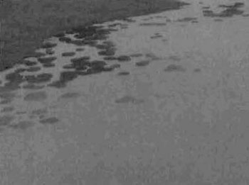
The wetlands associated with the Lake Abitibi region can be attributed to the damming of the Lake Abitibi Reservoir by Abitibi Price at Twin Falls. Wetlands are a dominant feature of the conservation reserve and account for almost 20% (not including forested swamps) of the area (Maps 3b, Appendix #8). Wetland types include; open water marsh (pond/water lily, tapegrass, pondweed, milfoil/coontail), meadow marsh (mostly sedges), poor fen/open bog (low shrub), treed bog to intermediate conifer swamp (black spruce), treed fen (tamarack) and rich conifer swamps (cedar). The most interesting feature of the wetlands is the perfectly round circles of bulrushes found in Swampy Creek, Teddy Marsh and just north of the Okikodosik Narrows block (Map 3a, Appendix #8). Ken Abraham (2003), a MNR wildlife/wetlands specialist, suggested it is a normal phenomenon where each circle represents growth from rhizomes of a single plant (cloning) in situations of narrow tolerances for other species or in response to stress such as water fluctuations.
Soils in many of the bays of the marshlands are predominantly black hurnics over silty clay mineral soils. Emergent aquatic vegetation found in the adjacent marshlands to Lake Abitibi is limited in diversity and distribution. Substantial areas within the many bays are devoid of emergent vegetation. However, close to shore and in protected areas cattail, spikerush, blue-joint grass, burreed, bulrush, arrowhead, horestail, and wild rice can be found. Wild rice is also found growing in the marshland systems, predominately in Teddy Bear Marsh but also within a couple of other bays. Submergent aquatic vegetation is present throughout the many bays and consists of pondweeds, coontail, bladderwort, and milfoil. The distribution of submergent plants within the wetland systems is very good and provides waterfowl with excellent foraging zones. Floating plants such as lily pads and floating leaf-burreed are also present in the marshlands.
Several of these wetlands serve as important wildlife habitats. Teddy Bear Marsh is located just west of a major flyway (migratory corridor) and is an excellent nesting and resting site for migratory birds (mainly waterfowl). The quality of waterfowl habitat would not be as high if it were not for the dam built at the outlet of the marsh. In 1984, Ducks Unlimited, in an agreement with MNR, built a dam and fish ladder for northern pike (to access their traditional spawning area) in order to reduce the water level fluctuations experienced on Lake Abitibi. The wetland on the east side of Lightning Point has important waterfowl nesting habitat. Kechewaig Creek, west of MacDougal Point, also has excellent waterfowl nesting habitat as well as good moose aquatic feeding areas (OMNR, 1999). Swampy Creek and the creeks at Okikodosik Narrows have potential to be good northern pike spawning and/or moose aquatic feeding areas. The marshlands, with their abundant aquatic vegetation, provides moose with high or very high quality moose aquatic feeding areas The number of moose observed during aerial inventory substantiates the quality of moose habitat in this Conservation Reserve.
Water levels within Lake Abitibi are continually fluctuating as a result of dams built on the Abitibi River. The lake is an important feature for bird colonies, with several heronries and a double crested cormorant colony observed in the Swampy Creek block (Burkhardt, 2002). Osprey nests were also observed within the Conservation Reserve.
Within the Narrows and MacDougal Point blocks there are two historical/archaeological sites. On the northeast corner of MacDougal Point a Hudson Bay Trading Post was operated by a man named Biederman. The second site of interest is located along the Narrows, and is an archaeological site of continental significance in relation to the Abitibi Narrows Shield Archaic peoples (OMNR, 1999).
Quality of representation:
The quality of the representation or the current characteristics of the natural features found within the conservation reserve are as important as the overall representative features that are being protected. A number of factors are considered in evaluating a site and they include the following criteria: diversity, condition, ecological factors, special features and current land use activities.
a) Diversity:
Diversity is the measure of the site’s life and earth heterogeneity. The evaluation is based on the number and range (variety) of the natural landscape features and landforms for earth science values and the relative richness and evenness of the site’s life science components. For this Conservation Reserve, the diversity is rated as medium and moderately skewed. There are 88 landform:vegetation formations across the entire Conservation Reserve but areas that account for less than 1% of the total are removed from the score. Taking this into account the modified landform:vegetation total is 26 (Table 3-1). Several areas, such as islands (bulrush circles) and rock outcrops in meadow marsh were included in the 26 landform:vegetation combinations although they were less than 1% in total site areas. These areas were uncommon to the overall site and thus add diversity to the Conservation Reserve. Old spruce fir (SF1) and mature spruce fir mixed (MW2) dominate the overall site on glaciolacustrine deposits and wetlands (Forest Resource Inventory; open muskeg) dominate on organic deposits. The Conservation Reserve has a good variety of diversity in stand ages. Harvesting has created young communities of black spruce and cedar dominant and mixed poplar stands. However, it is important to note that planted areas have low species diversity. Basically every SFU has immature, mature and old forest stands.
Diversity for the Conservation Reserve can be described as a whole or by individual blocks. Since there is no uniformity between the blocks it is fitting to describe each block individually. In most cases, the diversity rating was low, with the exception of the Narrows, which had medium diversity. The blocks were split between moderately and strongly skewed landform:vegetation combinations.
Teddy Bear Marsh
Teddy Bear Marsh has a good representation of forest communities ranging from Bw mixed hardwood to Sb mixedwood, but is dominated by meadow and cattail marshes. When SFU’s are considered, the diversity is greatly reduced. The block is dominated by fairly evenaged (mature) MW2 (spruce fir) on glaciolacustrine deposits (33.8%) with some representation from PO1 and BW1. The other dominant formations are marshes (meadow and cattail) (25.0%) and water (open water marsh) (10.8%) on organic deposits. In total, there were 32 landform:vegetation (L:V) combinations for 732 ha but with polygon slivers and areas accounting for less than 1%, the diversity score was reduced to 15 (Table 3-2). Three L:V’s were included into the total that were less than 1% in area and they include bedrock landforms that are not common to the block. Teddy Bear Marsh also contains within the open water marsh some established bulrush circles and in another area new circle formations. The marsh has low species diversity (dominated by sedges with some low shrubs) but good edge effects. The abundance of small bays increases the surface area of the marsh and provides good habitat for waterfowl. Dispersion of forest communities is low. MW2 is concentrated around the majority of the marsh with PO1 and BW1 located in pockets in each corner of the block.
Figure 4.0
Site: MacDougal Point Peninsula CR
Location: Teddy Bear Marsh
Aerial Recreation Inventory
September 06, 2002
Photo by B. Burkhardt
Taken from NW corner. Site dominated by meadow marsh (sedge, cattails) and open water marsh (tapegrass, waterlily, pondweeds, bulrush). Marsh surrounded by various Bw forest stands, Sb mixedwood, Po forests and Ce dominated conifer. Bulrush circles present in water.
Lightning Point
Lightning Point has 20 L:V combinations in 527 ha but the total was modified to 7, thus creating a low diversity score (Table 3-3). This block is dominated by immature Po communities of mixedwoods, predominant hardwoods and hardwood mix on mostly glaciolacustrine deposits with some pockets of bedrock-drift complex and bedrock outcrops along the shoreline. Outcrops are the result of the lake actions on the point. These Po communities are split into MW2 and PO1 (poplar). An arm of immature Bf conifer mixed (SF1) occurs on glaciolacustrine deposits. The different wetland communities and SB1 (black spruce lowland) occur on organic deposits. The whole block is influenced by the moderating effects of Lake Abitibi. Shoreline erosion and deposition has created alternating silt/clay and bedrock shorelines as well as small bays, resulting in a greater edge effect. A thin beach ridge near the south edge has isolated the poor fen/open bog wetland from water exposure.
Figure 5.0
Site: MacDougal Point Peninsula CR
Location: Lightning Point
Aerial Recreation Inventory
September 06, 2002
Photo by B. Burkhardt
MacDougal Point
Figure 6.0
Site: MacDougal Point Peninsula CR
Location: MacDougal Point
Aerial Recreation Inventory
September 06, 2002
Photo by B. Burkhardt
Photo taken at the top west shore looking SE in the Sb semitreed bog, treed bog and Sb intermediate conifer swamp and Ce rich conifer swamp complex. Silt/clay shore in bay.
MacDougal Point has the greatest diversity and dispersion of all the blocks with a total of 53 L:V combinations and a modified total of 20 L:V’s on 2375 ha (Table 34). Although MacDougal Point has the greatest diversity within the Conservation Reserve it is still rated as low for its size category. SB1, PO1, LC1 and MW2 can be found in pockets throughout the block. SB1 (semitreed bog, treed bog/intermediate conifer swamp) and LC1 (treed fen or rich conifer swamp) are found on three landforms. The dominant formation is old SF1 (cedar and black spruce lowlands), which accounts for almost half of the site. As in Lightning Point, this block is influenced by the moderating effects of Lake Abitibi, perhaps more so as it is greatly exposed to the north and south portion of the lake. Erosion, deposition and fluctuating water levels control the shoreline diversity. There is good diversity of wetland types, ranging from open water marshes to cattail marshes, poor fen/open bog and treed bogs to conifer swamps. There is also good diversity in forest age structure, ranging from immature (harvested) stands to mature stands in the south and north portions to old growth forests along the west side.
The Narrows
This block is different from the rest in that wetlands (aquatic) do not play a significant role and bedrockcontrolled ridges with extensive sediment cover form the primary landform (Kor, 2003). There are 28 L:V combinations and a modified total of 21 L:V’s within the 805 hectares, which rates the block as having medium diversity (Table 35). Several L:V’s that were less than 1% in total area were added to the diversity total as they were found only this block. They include old SF1 and old MW2 on bedrock outcrops, and rock (FRI’s) on either bedrock-drift complex or glaciolacustrine deposits. This block is moderately skewed towards immature SF1 on glaciolacustrine deposits, and mature SP1 and immature SF1 on bedrock outcrops. Features that would increase diversity include bedrock outcrops which were visible during the aerial survey but most were not able to be mapped and the fairly even distribution of old growth, mature stands and immature stands (due to harvesting).
Figure 7.0
Site: MacDougal Point Peninsula CR
Location: The Narrows (on left)
Aerial Recreation Inventory
September 06. 2002
Photo by B. Burkhardt
Swampy Creek
The Swampy Creek block has very low diversity for its size (31 L:V combinations in 1121 ha with a modified total of 14) (Table 36). The site is dominated by open muskeg (meadow marsh complex), mature LC1 and open water marsh on organic deposits, accounting for a little more than 50% of the block area total. There are no old growth forests within Swampy Creek; however immature SB1 areas are present. An interesting feature that adds to the diversity (L:V combination modified total) of the block are the bulrush circles that appear in several locations of Swampy Creek. These circles appear to be uncommon in the Northeast Region, based on aerial surveys conducted by MNR. Bulrush circles have also been observed in Echo Bay and at the mouth of the Spanish River, east of Sault Ste. Marie, Ontario. The many small bays in the meadow marsh complex increase the edge effect and provide good habitat for waterfowl and perhaps northern pike spawning areas.
Figure 8.0
Site: MacDougal Point Peninsula CR
Location: Swampy Creek
Aerial Recreation Inventory
September 06, 2002
Photo by B. Burkhardt
Okikodosik Narrows
This block has 32 L:V combinations and a modified total of 14 within 540 ha. Open muskeg (marsh complex) on organic deposits is the dominant feature of the block. The site is also dominated by immature PO1 and immature SF1 on glaciolacustrine deposits and PO1. Small islands of bedrock-drift complex and glaciolacustrine deposits within the marsh add to the diversity of the site. The edge effect is not as pronounced on the meadow marsh as in Teddy Bear Marsh or Swampy Creek but the complex has good diversity of different wetland types. Forest stand age does not add to the diversity of the site as the majority of the block is immature, although some mature PO1 stands are present along the north creek.
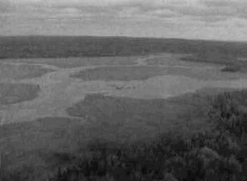
Figure 9.0
Site: MacDougal Point Peninsula CR
Location: Okikodosik Narrows
Aerial Recreation Inventory
September 06, 2002
Photo by B. Burkhardt
Taken from the north end looking south. Wetland complex of open water marsh, meadow marsh, shore fen, poor fen/open bog and thicket swamps. Surrounded by Po hardwood mixed, Bf mixedwood & Ce pure forest communities. Perfectly round bulrush circles in water (not part of site).
b) Condition:
Condition refers to the amount of disturbance that the site has experienced and includes both human and natural disturbance. Based on the aerial survey, the disturbance is rated as medium for the entire Conservation Reserve. Most of the disturbance is manmade and includes harvesting and water level fluctuations due to two power generating stations. Either clear cut or selectivecut harvesting has occurred within each if the six blocks. Good regeneration (either natural or artificial) has taken place in all areas. There are several roads and trails, most notably in Lightning Point and Okikodosik Narrows, which were created during the harvesting period. Although access to Lake Abitibi is limited to a couple of forest access roads here in Ontario, the same is not true for the far eastern portion of the lake that is found within the Province of Quebec. Along the eastern shore of the lake there are numerous access points from paved roads and in many locations community and agricultural development up to the shores of the lake. Several power generating dams exist along Abitibi River; the closest are the Twin Falls and Iroquois Falls stations. These cause fluctuating water levels on Lake Abitibi and as a result determine the type of wetland community found within each block. Fluctuating water levels also increase erosion on the silty clay shorelines and have an impact on fish spawning activity. Teddy Bear Marsh is not influenced by the power generating stations due to the dam/dyke structure built in 1984 by Ducks Unlimited to control water levels.
c) Ecological factors:
Wherever possible, the site’s boundaries should be created to include the greatest diversity of life and earth science features to provide the maximum ecological integrity. The site should be ecological selfcontained, bounded by natural features and include adequate area to protect the core ecosystems from adjacent land use activities (OMNR, 1992). Each of the blocks has biological, cultural and vectored boundaries. Biological boundaries include the shorelines of Lake Abitibi, creeks and rivers while cultural boundaries include harvest roads and trails. The presence of Lake Abitibi reduces the encroachment of human activities such as harvesting. Natural factors such as erosion will continue to have an effect on the area. Most of the vectored boundaries were added to the Narrows, Swampy Creek and Okikodosik Narrows blocks, likely protect the core areas (History Map, Appendix #8). For the Narrows, it may have been better to use the roads and follow the lakeshore. In a sensitive area report, it was suggested that designating an 800meter area along the Narrows would protect the significant archaeological site which is present there (OMNR, 1973).
Currently there are no minimum size standards for conservation reserves under different landscape conditions. However, a minimum size standard of 2000 ha has been established for natural environment parks by Ontario Parks (OMNR, 1992). This minimum standard was considered necessary to protect representative landscapes as well as allow for low intensity recreational activities. The MacDougal Point Peninsula Conservation Reserve is over 6000 ha in size but the conservation reserve is divided into six separate blocks which, except for MacDougal Point, are less than 2000 ha in size. To add some integrity to the Conservation Reserve, a strip of shoreline along Lake Abitibi could be added to connect the individual blocks and create a link with Lake Abitibi Islands Provincial Park (P1622).
d) Special features:
There are several special features within the MacDougal Point Peninsula Conservation Reserve. The bulrush circles found in Swampy Creek (the most dominant site), Okikodosik Narrows (mostly outside the block) and Teddy Bear Marsh (some small ones but also some new formations) are an interesting phenomena. Another special feature is the fact that every block within the Conservation Reserve is unique from the others. MacDougal Point has a high proportion of swamp and bog wetlands, the Narrows is unique due to the bedrockcontrolled landforms and lack of aquatic wetlands, Swampy Creek has many different types of wetlands as well as bulrush circles, Okikodosik Narrows has an interesting mixture of wetlands and trembling aspen and balsam fir forest communities, Teddy Bear Marsh has a large meadow marsh, the Ducks Unlimited dam/dyke/fish ladder and the variety of forest communities and finally, Lightning Point contains a mixture of all five. The number of osprey that were observed during the recreation inventory work suggests that the shallow fishrich waters of Lake Abitibi with the surrounding large pine forested lands and numerous islands create an ideal habitat for many of the predatory birds that rely on fish availability during their breeding season.
Figure 10.0
Site: MacDougal Point Peninsula CR
Location: Okikodosik Narrows
Aerial Recreation Inventory
September 06, 2002
Photo by B. Burkhardt
e) Current land use activities
The Lake Abitibi Area receives many sport and recreational enthusiasts every year. Given the vast size of the lake and the diversity of the six blocks which make up the MacDougal Point Conservation Reserve there are many visitors, pursuing various different types of activities. In the summer season fishermen, hikers, canoeists, sailors, campers and ATV’ers are present on the lake and within the sites. During the fall large game hunters, fishermen, and waterfowl hunters make up the majority of the visitors. The winter months see many ice fishermen and ice hut communities on Lake Abitibi as well as snowmobilers and trappers.
Summary:
MacDougal Point Peninsula Conservation Reserve is a protected landform represented by an area primarily dominated with mixed conifer forest, mixed deciduous forest and sparse forest located on a lacustrine dominated deposit. The Conservation Reserve is dominated by glaciolacustrine deposits with some areas of bedrock-drift complex, organic deposits and a few outcrops. A total of 88 landform:vegetation combinations were determined throughout the site. Forest communities are dominated by SF1 (equivalent to mixed conifer forest which includes Ce mixedwood, Bf conifer mixed, Sb predominant conifer, etc.), MW2 (equivalent to mixed deciduous which includes Bw hardwood mixed, Po mixed wood, etc.) and harvested areas and treed bogs which are equivalent to sparse forest. Wetlands (FRI) and water also play a significant role in the conservation reserve as they account for almost 20% of the area. Wetlands included open water marsh, meadow marshes, shore fens, etc. The shorelines of Lake Abitibi and the wetlands within Swampy Creek and Okikodosik Narrows and the fish habitat created by these features, are viewed to be the most sensitive areas within the site. These areas can be affected by fluctuating water levels created by the hydro dam at Twin Falls. Any development adjacent to these waterbodies may cause erosion or contamination to the waterways, having a direct effect on the waterway and/or wetlands present within the site. This site has a high activity attraction capability. The six block locations within the remote forested landscape and primary access from Lake Abitibi limits the sites current backcountry travel qualities but not its geographical significance.
Natural heritage representative features
This site is representative of lacustrine deposit with mixed conifer forest, mixed deciduous forest and sparse forest. The Conservation Reserve is dominated by glaciolacustrine deposits with some areas of bedrock-drift complex, organic deposits and a few outcrops. Small raised beach bluffs cut into these deposits and are a feature of the area and the Conservation Reserve. The raised beaches and modern beach bluffs are valuable indicators of past processes in the Barlow-Ojibway basin, and are considered regionally significant. All other geological features are considered locally significant. Due to the fine-grained nature of the substrate, the delicate forms of the features and the high water table, all features except the exposed bedrock areas are considered to be highly susceptible to erosion and/or alteration if the vegetation cover is disturbed.
Wetlands and water account for almost 20% of the Conservation Reserve. Wetlands included open water marsh, meadow marshes, shore fens, conifer swamps and open bog. The shorelines of Lake Abitibi, wetlands within Swampy Creek and Okikodosik Narrows and fish habitat throughout can all be affected by fluctuating water levels created by the hydro dam at Twin Falls. Forest communities are dominated by Spruce/Fir mixes, including Cedar mixedwood, Balsalm fir conifer mixedwood and Black Spruce predominant conifer wood. Mixed deciduous forests include white birch hardwood mixed and poplar mixedwood. Harvested areas and treed bogs are also present and are equivalent to sparse forest.
Landform Vegetation (LV) combinations, based on standard forest units
Table 3-1: L:V combinations, developmental stage and landform1 for C1714
| BW1 | LC1 | MW2 | PO1 | SB1 | SF1 | SP1 | Open Muskeg | Treed Muskeg | Water | Brush/Alder | Stream Buffer | Island | Rock | Total | Modified total | |
|---|---|---|---|---|---|---|---|---|---|---|---|---|---|---|---|---|
| 9 | I | I, M, O2 | I, M, O2 | I, M | I, M,O | I, M, O2 | M | ✘ | ✘ | ✘ | ✘ | ✘ | ✘3 | N/A | 22 | 8 |
| 9/6b | I | I, M, O2 | I, M | I | I, M, O2 | I, M, O2 | N/A | ✘ | ✘ | ✘ | ✘ | ✘ | N/A | N/A | 18 | 1 |
| 6c | N/A | M3 | N/A | N/A | N/A | I, O | N/A | N/A | N/A | N/A | N/A | N/A | N/A | ✘3 | 4 | 2 |
| 6b | I, M | I, M, O2 | I, M, O2 | I, M, O2 | I, M, O2 | I, M, O2 | M | ✘ | ✘ | ✘ | ✘ | ✘ | N/A | N/A | 23 | 9 |
| 2d | N/A | I | I, O | M | N/A | I | N/A | ✘ | N/A | ✘ | ✘ | N/A | N/A | N/A | 8 | 0 |
| 2 | N/A | N/A | O | I | N/A | I, M | M | N/A | N/A | N/A | N/A | N/A | N/A | ✘3 | 6 | 1 |
| 1 | I | N/A | I, O3 | N/A | N/A | I | M | ✘3 | N/A | N/A | N/A | N/A | ✘ | N/A | 7 | 5 |
| Total | 5 | 11 | 13 | 8 | 9 | 15 | 4 | 5 | 3 | 4 | 4 | 3 | 2 | 2 | 88 | N/A |
| Modified total | 0 | 3 | 5 | 2 | 3 | 4 | 1 | 2 | 1 | 1 | 1 | 0 | 1 | 2 | N/A | 26 |
Table 3-2: Landform:Vegetation combinations based on Standard Forest Unit, Developmental Stage and Landform1 for C1714 - Teddy Bear Marsh
| BW1 | LC1 | MW2 | PO1 | SF1 | Open Muskeg | Treed Muskeg | Water | Stream Buffer | Total | Modified total | |
|---|---|---|---|---|---|---|---|---|---|---|---|
| 9 | 2,M | M | M, O | I, M | N/A | ✘ | ✘ | ✘ | ✘ | 11 | 4 |
| 9/6b | N/A | M | M | N/A | N/A | N/A | ✘ | N/A | ✘ | 4 | 1 |
| 6b | I, M | M | M, O | I, M | M | ✘ | ✘ | ✘ | ✘ | 12 | 6 |
| 2 | N/A | N/A | O3 | I | N/A | N/A | N/A | N/A | N/A | 2 | 2 |
| 1 | N/A | N/A | O3 | N/A | N/A | ✘3 | N/A | ✘ | N/A | 3 | 2 |
| Total | 4 | 3 | 7 | 5 | 1 | 3 | 3 | 3 | 3 | 32 | N/A |
| Modified total | 2 | 1 | 5 | 2 | 0 | 3 | 1 | 1 | 0 | N/A | 15 |
Table 3-3: Landform:Vegetation Combinations based on Standard Forest Unit, Developmental Stage and Landform1 for C 1714 – Lightning Point
| BW1 | MW2 | PO1 | SB1 | SF1 | Open Muskeg | Water | Brush/Alder | Total | Modified total | |
|---|---|---|---|---|---|---|---|---|---|---|
| 9 | N/A | I | I | I 3 | I | ✘ | ✘ | ✘ | 8 | 2 |
| 6b | I2 | I | I | N/A | I, M | ✘ | ✘ | ✘ | 8 | 3 |
| 2d | N/A | I 3 | N/A | I | N/A | N/A | N/A | N/A | 2 | 1 |
| 1 | I | I | N/A | N/A | N/A | N/A | ✘ | N/A | 3 | 1 |
| Total | 2 | 4 | 2 | 2 | 3 | 2 | 3 | 2 | 21 | N/A |
| Modified total | 0 | 3 | 1 | 1 | 1 | 1 | 0 | 0 | N/A | 7 |
Table 3-4: Landform:Vegetation combinations based on Standard Forest Unit, Developmental Stage and Landform1 for C1714 MacDougal Point2
| BW1 | LC1 | MW2 | PO1 | SB1 | SF1 | SP1 | Open Muskeg | Treed Muskeg | Brush/Alder | Water | Stream Buffer | Total | Modified total | |
|---|---|---|---|---|---|---|---|---|---|---|---|---|---|---|
| 9 | I2 | I3, M, O | I, M, O2 | N/A | I, M, O2 | I, M, O2 | M | ✘ | ✘ | ✘ | ✘ | ✘ | 19 | 7 |
| 9/6b | I | I, M, O2 | I, M | N/A | I, M, O2 | M, O | N/A | ✘ | N/A | ✘ | N/A | ✘ | 14 | 3 |
| 6b | I | I, M, O2 | I, M, O2 | I, M | I, M, O2 | I, M, O2 | M | ✘ | N/A | ✘ | ✘ | ✘ | 20 | 10 |
| Total | 3 | 9 | 8 | 2 | 9 | 8 | 2 | 3 | 1 | 3 | 2 | 3 | 53 | N/A |
| Modified total | 0 | 2 | 3 | 2 | 6 | 4 | 0 | 1 | 0 | N/A | 1 | 0 | N/A | 20 |
Table 3-5: Landform:Vegetation combinations based on Standard Forest Unit, Developmental Stage and Landform1 for C1714 The Narrows2
| LC1 | MW2 | PO1 | SB1 | SF1 | SP1 | Open Muskeg | Water | Brush/Alder | Stream Buffer | Rock | Total | Modified total | |
|---|---|---|---|---|---|---|---|---|---|---|---|---|---|
| 6c | M2 | N/A | N/A | N/A | I, O | N/A | N/A | N/A | N/A | N/A | N/A | 3 | 2 |
| 6b | I, M | M, O | I, O | I | I, M, O2 | M | ✘ | ✘ | ✘ | ✘ | ✘ | 16 | 10 |
| 2 | N/A | N/A | O | N/A | I, M | M | N/A | N/A | N/A | N/A | ✘ | 5 | 5 |
| 1 | N/A | O3 | N/A | N/A | I | M | N/A | N/A | N/A | N/A | ✘ | 4 | 3 |
| Total | 3 | 3 | 3 | 1 | 8 | 3 | 1 | 1 | 1 | 1 | 3 | 28 | N/A |
| Modified total | 2 | 3 | 2 | 1 | 7 | 3 | 0 | 0 | 0 | 0 | 2 | N/A | 20 |
Table 3-6: Landform:Vegetation combinations based on Standard Forest Unit, Developmental Stage and Landform1 for C1714 Swampy Creek
| BW1 | LC1 | MW2 | SB1 | SF1 | Open Muskeg | Treed Muskeg | Brush/Alder | Water | Island | Stream Buffer | Total | Modified total | |
|---|---|---|---|---|---|---|---|---|---|---|---|---|---|
| 9 | N/A | I, M | O | I, M | I, M | ✘ | ✘ | ✘ | ✘ | ✘3 | ✘ | 13 | 10 |
| 9/6b | I2 | N/A | N/A | I | I, M | ✘ | ✘ | ✘ | ✘ | N/A | ✘ | 9 | 1 |
| 6b | N/A | I, M | N/A | I | I, M | ✘ | ✘ | ✘ | ✘ | N/A | N/A | 9 | 3 |
| Total | 1 | 4 | 1 | 4 | 6 | 3 | 3 | 3 | 3 | 1 | 2 | 31 | N/A |
| Modified total | 0 | 3 | 0 | 4 | 2 | 1 | 1 | 1 | 1 | 1 | 0 | N/A | 14 |
Table 3-7: Landform:Vegetation combinations based on Standard Forest Unit, Developmental Stage and Landform1 for C1714 Okikodosik Narrows
| LC1 | MW2 | PO1 | SB1 | SF1 | Open Muskeg | Water | Brush/Alder | Stream Buffer | Total | Modified total | |
|---|---|---|---|---|---|---|---|---|---|---|---|
| 9 | I2 | I, M | I, M | N/A | I, O | ✘ | ✘ | ✘ | ✘ | 11 | 5 |
| 9/6b | N/A | I | I | N/A | N/A | ✘ | N/A | N/A | N/A | 3 | 1 |
| 6b | I | I, M | I, M | I | I | ✘3 | ✘ | ✘ | ✘ | 11 | 6 |
| 2d | I | M | M | N/A | I | ✘ | ✘ | ✘ | N/A | 7 | 2 |
| Total | 3 | 6 | 6 | 1 | 4 | 4 | 3 | 3 | 2 | 32 | N/A |
| Modified total | 1 | 4 | 4 | 0 | 1 | 1 | 1 | 1 | 0 | N/A | 14 |
- 1 Landform based on Rik Kristjansson, 2001
- 2 I= Immature, M =Mature, 0 =Old (based on NEST Technical Report TN-040, page 21) Bold indicates community included in modified total
- 3 Areas less than 10 hectares (<1%) but are considered to add to diversity
Forest Resource Inventory (FRI) data
- Dominant species, wetlands, and depleted areas
- See Forest Communities Composition Map (Map 2a, Appendix #8)
5.1 Social/economic interest in area
a) Linkage to local communities:
MacDougal Point Peninsula Conservation Reserve is a 6,035 hectare parcel of Crown land that is situated approximately 65 km northeast of the Town of Kirkland Lake, 45 km east of the Town of Iroquois Falls and 4 km west of the Ontario/Quebec border. The Conservation Reserve is located within Rand, Frecheville and Stoughton townships in the Kirkland Lake MNR District and in an unnamed township in the Cochrane MNR District. The Kirkland Lake MNR has assumed responsibility for the entire site. The site is made up of six separate blocks situated along the shores of Lake Abitibi. Access to the site blocks and Lake Abitibi from the Province of Ontario is by remote roads and limited boat access points on the lake. Lake Abitibi is far more accessible from the Province of Quebec, with paved roads and built up areas adjacent to the lake. There are several roads/trails, most notably in Lightning Point, Okikodosik Narrows and Swampy Creek, which were created during the harvesting period. However, during ground recreation inventory work it was discovered these trails/roads were overgrown and no longer passable. The six blocks representing the MacDougal Point Peninsula Conservation Reserve are as follows MacDougal Point, the Narrows, Swampy Creek, Lightning Point, Okikodosik Narrows and Teddy Bear Marsh, all are found around the shores within the south portion of Lake Abitibi (Locator Map, Appendix #7).
Current uses are fishing, hunting, canoeing, sailing, camping, snowmobiling and trapping. Potential recreational activities could include hiking, rock climbing, bird watching, photography, painting or nature study.
b) Heritage estate contributions
MacDougal Point Peninsula Conservation Reserve contributes to the province’s parks and protected areas system through its regulation, representation and the longterm management of natural heritage values. By allocating these lands to the parks and protected areas system, the province has ensured a certain level of permanence by distinguishing the site and its values from the broader general use or more extensively managed landscape. In addition, its natural features are, and will be available for present and future generations to enjoy and explore.
c) Aboriginal groups
The MacDougal Point Peninsula Conservation Reserve falls within the Wagoshig First Nations identified notification area. They were therefore notified of the planning and requested a draft copy of the SCI be sent to them. A second meeting was set up to receive feedback from the community. No major concerns were raised at this time.
d) Mining interests:
There are no mining leases within the conservation reserve. Mining and surface rights were withdrawn from staking within the conservation reserve’s boundaries under the Mining Act (RSO 1990 Chapter M.14). This interim protection was established in 1999 to ensure the core values of the site remain until the conservation reserve could be formally regulated.
e) Forest and fire management history:
A recent aerial reconnaissance survey showed significant harvest areas throughout the areas surrounding the sites and within all of the block locations. Regeneration is deemed successful in all harvested areas. During Ground Inventory work 2003 harvesting operations were observed to the south and north of the southern Lake Abitibi basin in between several of the conservation blocks.
There has been no recent wildfire activity within the Conservation Reserve blocks. Past natural disturbances include a forest fire in 1921 south of Lightning Point and west of Teddy Bear Marsh. Also in 1921 a fire occurred northwest of the Okikodosik Narrows block and in 1984 a large fire occurred south of Teddy Bear Marsh.
5.2 Natural heritage stewardship
The Conservation Reserve is dominated by cedar mixedwoods, black spruce and poplar mixedwoods (Map 2a, Appendix #8). All forest stands are dominated by cedar, black spruce, poplar, balsam fir or white birch, typical of the Claybelt region. Mixedwood stands of either poplar or balsam fir dominance (or cedar on MacDougal Point) are associated with the glaciolacustrine deposits while conifer dominated stands (most of the stand was more conifer in composition than hardwood) are associated with either organic deposits or organic deposits over glaciolacustrine. Stocking of the forest communities ranged from 0% (harvested and barren-and-scattered areas) to 100%, the average being approximately 41 to 80% (Map 2b, Appendix #8). Ages ranged from 0 (harvest and barren-and-scattered areas) to 161 years (Map 2c, Appendix #8). By development stage, the majority of the balsam fir stands were immature, white birch ranged from immature to old, most of the cedar stands were mature or old with one area of immature (harvest area), poplar ranged from immature with some old stands and black spruce stands ranged from immature to old. Development stages were assessed based on the SFU (standard forest unit) for each forest community. Forest communities were classified into 7 SFU’s (Map 2d, Appendix #8), SF1 (spruce fir), MW2 (spruce fir mixed), SB1 (black spruce lowland), PO1 (poplar), LC1 (lowland conifer), BW1 (birch poplar) and SP1 (spruce pine). Old growth is dominant on MacDougal Point and the Narrows and can be found north of Teddy Bear Marsh. Most of Sb, La and Ce pure stands that were considered barren-and-scattered are most in likelihood old growth stands and definitely not immature.
5.3 Fish and wildlife
The current composition of Lake Abitibi is that of a typical shallow, turbid, warm water fishery. Fish species present are walleye, northern pike, yellow perch, lake whitefish, goldeye, sauger, lake sturgeon, freshwater drum, white sucker, brown bullhead, burbot and others. In addition, when lake waters are low beaches are located along the shores of the sites.
Figure 11.0
Site: MacDougal Point Peninsula CR
Location: The Narrows
Ground Recreation Inventory
August 06, 2003
Photo by Rick Gordon
North west shore of the Narrows block. Shown is a beach that due to higher water conditions is mostly submerged. To the right is a rocky out crop and to the left bulrushes and tape grass. Behind is mixed forest dominated by old fir/spruce.
Several of these wetlands serve as important wildlife habitats. The Teddy Bear Marsh, just west of a major flyway (migratory corridor), is an excellent site for nesting and resting points for migratory birds (mainly waterfowl). In 1984, Ducks Unlimited, in an agreement with MNR, built a dam and fish ladder for northern pike (to access their traditional spawning area) in order to reduce the water level fluctuations experienced on Lake Abitibi. The marsh, with its abundant aquatic vegetation, provides moose with high to very high quality moose aquatic feeding areas. The wetland on the east side of Lightning Point has important waterfowl nesting habitat. Kechewaig Creek, west of MacDougal Point, also has excellent waterfowl nesting habitat as well as good moose aquatic feeding areas (OMNR, 1999). Swampy Creek and the creeks at Okikodosik Narrows have potential to be good northern pike spawning and/or moose aquatic feeding areas. The number of moose observed during aerial inventory substantiates the quality of moose habitat. Numerous other important fish spawning areas are located within Lake Abitibi (Map 3a, Appendix #8). The lake is also important for bird colonies. There are several heronries; a double crested cormorant colony (observed in the Swampy Creek block and osprey nests located within the Conservation Reserve boundaries.
The Lake Abitibi area is heavily utilized for hunting activities. Many hunt camps are found along the remote forest access roads leading to Lake Abitibi. Hunting blinds can also be found within the blocks and in various marshland locations throughout the area. Large game is plentiful and this draws a number of hunters to the area and to the reserve. With the extensive marshland and waterfowl habitat found within the reserve blocks and surrounding area, waterfowl hunter numbers can be described as numerous. Trapping is conducted throughout the conservation reserve with a registered trappers cabin found within the Teddy Bear Marsh block. Although there are no trapping licences on record for the MacDougal Point block, it is safe to assume that the area is trapped by community members of the adjacent Wahgoshig First Nations Reserve. The dominant forest stands as well as open sections of kettle lake wetlands and bogs provide year round habitat for moose and other species. Black bear, fox, marten, fisher, beaver, mink, otter, upland game birds and migratory waterfowl are also found in the area.
5.4 Cultural heritage stewardship
To date, a detailed assessment of cultural resources has not been carried out.
5.5 Land use/existing development
This Conservation Reserve is situated entirely on Crown Land and is unencumbered by any patented land, land use permits, or leases.
Ducks Unlimited has established a dyke/fish ladder system within the Teddy Bear Marsh block of the conservation reserve to maintain and enhance waterfowl habitat. Any required maintenance or changes of the structures involved will be subject to a Test of Compatibility to ensure the continued protection of values and features within the conservation reserve.
Mining and surface rights have been withdrawn from staking within the conservation reserve boundaries under the Mining Act (RSO 1990, Chapter M.14). Therefore, no new claims can be staked within the CR boundary.
5.6 Commercial land use
Present commercial use activities overlapping the site include one bear management area (BMA28009) in the Kirkland Lake District, and four trap line areas, two in the Kirkland Lake District (KL005, KL012) and two in the Cochrane District (CC54, CC55) (Map 3a, Appendix #8). Although there are no records of a registered trapline on MacDougal Point there is a good probability that it is being utilized as a trap area given its close proximity to the adjacent Wahgoshig First Nation Reserve.
5.7 Tourism/recreation use/opportunities
Lake Abitibi is the 5th largest inland lake in Ontario, this fact along with the presence of large and small mammals, mixed forests, rock walls, beaches, and aquatic flora and fauna makes it an attractive recreation area. Existing recreational uses in this site and immediately surrounding the site include trapping, hunting (large and small game and waterfowl), camping, swimming, sport fishing, ice fishing, sailing, snowmobiling and canoeing. There is also potential for activities such as ATV use, bird watching, hiking, rock climbing, water sports, painting and nature and wildlife study.
For a more detailed report and summary of the recreational use and potential, refer to the Recreational Inventory Report and Checksheet (Appendix #3).
5.8 Client services
Currently, visitor services are limited to responding to inquiries about access, natural heritage features and boundaries. No formal information or interpretive facilities currently exist within the conservation reserve. Other client services include providing clients with maps, fact sheets, and other information gathered on the area, such as the Earth/Life Sciences and Recreational Inventory work.
6.0 Management guidelines
6.1 Management planning strategies
The land use intent outlined in the OLL LUS (MNR, 1999) provides context and direction to land use, resource management, and operational planning activities on Crown Land in the planning area and within OLL site boundaries. Commitments identified in the OLL LUS and current legislation (Policy 3.03.05 PLA) forms the basis for land use within the MacDougal Point Peninsula Conservation Reserve. Management strategies for these uses must consider the short and longterm objectives for the conservation reserve. For up to date information on permitted uses refer to the Crown Land Use Atlas (MNR, 2002) (Appendix #6).
Proposed new uses and development will be reviewed on a casebycase basis. A Test of Compatibility, (Procedural Guideline B - Land Uses (PL 3.30.05)) must be completed before proposals can be accepted. In all cases, ensuring that the natural values of the conservation reserve are not negatively affected by current and future activities will be the priority. Therefore any application for new specific uses will be carefully studied and reviewed.
Forest reserves
Under the OLL LUS, mining and related access will be allowed in a forest reserve. For those activities that could negatively influence the natural heritage values within the FR and/or the CR, the district will work with the proponent to identify and mitigate potential mining or natural heritage concerns. Mining will not occur in any portion of the regulated conservation reserve boundary. No forest reserves are found within the MacDougal Point Peninsula Conservation Reserve.
6.2 “State of the Resource” management strategies
The development of this SCI and the long term management and protection of the will be under the direction of the MNR’s Kirkland Lake District, Elk Lake-Matheson Area Supervisor. The following management strategies have been created to achieve the goal and objectives stated earlier in this management document.
Natural heritage stewardship
The management intent for the MacDougal Point Peninsula Conservation Reserve is to allow for natural ecosystems, processes and features to operate undisturbed with minimal human interference while providing educational, research and recreational activities. Forest ecosystem renewal will only be entertained via a separate vegetation management plan. As part of any future vegetation management plan the site and its Site District will be reevaluated with respect to their known landform/vegetation features to determine if the past harvested areas could contribute additional landform/vegetation values to the Site District.
In addition, the vegetation management plan should include, but not be limited to:
- restoration ecology objectives (e.g. representation) for the area in context with the Site District;
- consideration of current provincial strategies (e.g. management of white pine);
- longterm conservation reserve considerations (e.g. recreational objectives) and possibly landscape objectives (e.g. contributions to landscape wildlife objectives).
Fire is recognized as an essential process fundamental to the ecological integrity of conservation reserves. In accordance with existing Conservation Reserve Policy and the Forest Fire Management Strategy for Ontario, forest fire protection will be carried out as on surrounding lands.
Whenever feasible the MNR fire program will endeavor to use “ light hand on the land” techniques, which do not unduly disturb the landscape, in this conservation reserve. Examples of light hand on the land techniques may include limiting the use of heavy equipment, utilizing high water bomber drops, nonuse of foaming agents and limiting the number of trees felled during the fire response efforts.
Opportunities for prescribed burning to achieve/emulate ecological or resource management objectives may be considered. These management objectives will be developed with public consultation prior to any prescribed burning, and reflected in the document that provides management direction for this conservation reserve. Plans for any prescribed burning will be developed in accordance with the MNR Prescribed Bum Planning Manual, and the Class Environmental Assessment for Provincial Parks and Conservation Reserves (approval pending).
Defining compatible uses, enforcing regulations and monitoring and mitigating issues will protect all earth and life science features. Industrial activities such as commercial timber harvest and new hydro generation will not be permitted within the conservation reserve. Permits for fuelwood will not be issued. New energy transmission, communication and transportation corridors or construction of facilities are not permitted within the boundaries of the conservation reserve. Such structures negatively impact the quality of the representative features that require protection. Alternatives should be reviewed via larger landscape planning processes. New roads for resource extraction will not be permitted. Other activities that do not pass a Test of Compatibility will be prohibited (MNR Policy 3.03.05, 1997).
Intentional introduction of exotic and/or invasive species will not be permitted. Programs may be developed to control forest insects and diseases where they threaten significant heritage, aesthetic, or economic values. Where control is desirable, it will be directed as narrowly as possible to the specific insect or disease. Biological or nonintrusive solutions should be applied whenever possible.
The collection/removal of vegetation and parts thereof will not be permitted; however, subject to a Test of Compatibility, the Area Supervisor may authorize such activities for purposes of rehabilitating degraded sites within the reserve, collecting seeds for maintaining genetic stock and/or for inventory or research purposes.
Silvicultural assessment of the previous clearcut areas in the northern section of the site should be conducted to support any future vegetative management plan. The evaluation should consider but not be limited to the following objectives:
- describing the current forest condition;
- determining soil type and depth;
- defining potential restoration prescriptions. Such prescriptions must consider current silvicultural science and guidelines and additional objectives established by the MNR.
MNR will provide leadership and direction for maintaining the integrity of this site as a heritage estate. To ensure MNR protection objectives are fully met within the conservation reserve, activities on the surrounding landscape must consider the site’s objectives and heritage values. Research, education and interpretation will be encouraged to provide a better understanding of the management and protection of the natural heritage values and will be fostered through local and regional natural heritage programs, initiatives and partnerships.
The conservation reserve will be managed by allowing natural ecosystems, processes, and features to function normally, with minimal human interference.
Fish and wildlife
Fish and wildlife resources will continue to be managed in accordance with specific policies and regulations defined by the Ontario Ministry of Natural Resources under the Fish and Wildlife Conservation Act and the Kirkland Lake District, Elk Lake/Matheson Area Supervisor. The final decision to allow stocking in the MacDougal Point Peninsula Conservation Reserve lies with the approval of the Kirkland Lake District Manager.
Fishing and hunting is expected to continue at moderate levels of intensity. A planned trail and viewing area development may enhance wildlife viewing activities. Any future trail development will require a Test of Compatibility.
Cultural heritage
When possible, the Ministry of Natural Resources will continue to work with the Ontario Ministry of Culture, Tourism and Recreation in identifying archaeological sites to be protected. To fully manage and protect sites, the development of a field survey program would be required. However, at this time additional field surveys within the Conservation Reserve are not recommended.
Development, research and education proposals may be considered in accordance with the Test of Compatibility and Conserving a Future for our Past: Archaeology, Land Use Planning & Development in Ontario, Section 3 (MCzCR, 1997).
Land use and development
The sale of lands within the conservation reserve is not permitted as per the OLL LUS (MNR, 1999). Existing authorized trails can continue to be used and maintained, unless there are significant demonstrated conflicts. New trails will only be allowed if a Test of Compatibility is passed. Any new trail development will require an amendment to the SCI. The cutting of trees for noncommercial purposes (e.g. fuelwood) is not permitted except as required for approved development activity (e.g. trail, viewing site, etc.).
New roads for resource extraction will not be permitted. Abandoned forest extraction roads will not be actively maintained.
There are no other forms of tenure in the conservation reserve other than legal agreements with registered trappers, bear management area operators and baitfish licensees. The construction of new trap cabins will not be permitted; however existing cabins may continue to be used (LUS MNR, 1999).
Traditional uses within the conservation reserve will continue to be permitted; however, the goal will be to resolve conflicts regarding incompatibility between uses and to ensure that identified values are adequately protected.
Commercial use
All existing commercial resource use activities (i.e. trapping, baitfish harvesting, fishing and wild rice harvesting) are permitted to continue and new uses (with the exception of commercial bear hunting) may be introduced, subject to protection of the conservation reserve’s natural heritage values (i.e. Test of Compatibility).
Commercial bear hunting (within SMA) operations may continue and the transfer of existing licenses is allowed, providing the activity has been licensed/permitted since January 1, 1992. Licences to provide Bear Hunting Services will not be issued in areas where issuance has not occurred since January 1, 1992.
Existing commercial fur harvesting operations are permitted to continue. New operations may be considered subject to a Test of Compatibility.
Aboriginal interests
MacDougal Point Peninsula Conservation Reserve is within the Wahgoshig First Nation’s area of interest. Aboriginal and treaty rights will continue to be respected throughout the management of this conservation reserve. Any future proposal(s) and or decision(s) that have potential impact(s) on individual aboriginal values and or communities will involve additional consultation with the affected aboriginal groups. Neither the regulation of this conservation reserve nor the approval of this SCI will have bearing on the Wahgoshig traditional land uses.
Tourism/recreation
The earth and life science features and their protection shall be the overall theme for tourism. Smallscale infrastructures for enhancing tourism and recreation (i.e., warmup shelter) may be considered, providing they pass a Test of Compatibility and other MNR requirements.
Most recreational activities that have traditionally been enjoyed in the area can continue provided they pose no threat to the natural ecosystems and features protected by the conservation reserve. These permitted activities include walking, hiking, wildlife viewing, fishing, hunting, snow shoeing, and crosscountry skiing.
Snowmobiles and all-terrain vehicles (ATVs) are permitted on existing trails and forest access roads within the Conservation Reserve. Under the OLL LUS (MNR, 1999), all mechanized travel is restricted to existing trails. Off trail vehicle use is permitted for the retrieval of game only. The use of existing trails, within the MacDougal Point Peninsula Conservation Reserve, does not degrade the values of this site.
Existing trails for hiking, snowmobiling, ATV use, cycling, horseback riding and crosscountry skiing can continue. To ensure the quality of the representation is maintained, all trails and old forest access roads within the site should be identified via new technologies (i.e. GPS) to ensure a record of these features exists. New trails can be considered through a Test of Compatibility.
Finally, conflict resolution between recreational uses will be a priority. This will be achieved by adhering to the objectives of this SCI with input from relevant user groups. The level of safety and compatibility between activities will determine permitted uses (i.e. Test of Compatibility).
Client services
Clients indicating their interest in the management, planning and future use of this conservation reserve will be put on a mailing list and notified of any future planning concerning the site.
Present client services such as supplying maps, fact sheets and other information will also continue. Information may be delivered from different sources; however, MNR will be the lead agency for responding to inquiries regarding access, permitted and restricted activities, values and recreation opportunities. A management agreement may be pursued with an appropriate partner to share responsibilities for information services and the delivery of other aspects of this SCI in the future.
6.3 Specific feature/area/zone management strategies
There are no specific management strategies for the maintenance/protection/enhancement of selected resources within the conservation reserve. Development of such strategies will require an amendment to the SCI.
6.4 Promote inventory, monitoring and assessment reporting (IMAR), and research
Scientific research by qualified individuals, which contributes to the knowledge of natural and cultural history, and to environmental and recreational management, will be encouraged provided it follows the guidelines outlined in Procedural Guideline C Research Activities in Conservation Reserves (Appendix #5).
Additional life science inventory or research is required at this time to refine values and features. Additional assessment and monitoring of the disturbed areas, including trail and old road locations, within the site should occur prior to any additional management direction being finalized in a vegetation management plan for the area.
Research related to the study of natural processes will be encouraged provided it does not harm the values of the reserve. The Elk Lake/Matheson Area Supervisor or District Manager may approve the removal of any natural or cultural specimen by qualified researchers. All such materials removed remain the property of the Ministry of Natural Resources. All research programs will require the approval of the Ministry of Natural Resources and will be subject to Ministry policy and other legislation.
New developments such as campsites, privies, trails or developed access points or activities will not be considered until a Test of Compatibility is conducted and the proposal is approved by the Elk Lake/ Matheson Area Supervisor or District Manager. Existing roads can continue to be used, but new roads for resource extraction will not be permitted, with the exception of necessary access for mineral exploration and development. The Test of Compatibility or environmental screening process could include a review of the demand for structures or activities and may require more detailed life or earth science or cultural information and possibly more detailed management plan.
Approved research activities and facilities will be compatible with the site’s protection objective. Permanent plots or observation stations may be established to which researchers can return over time. Any site that is disturbed will be rehabilitated as closely as possible to its original state.
6.5 Implementation, and plan review strategies
The MacDougal Point Peninsula Conservation Reserve SCI will be reviewed on an ongoing basis and as required.
Implementation of the SCI and management of the reserve are the responsibility of the Elk Lake/Matheson Area Supervisor. Partnerships may be pursued to address management needs.
If changes in management direction are needed at any time, the significance of the changes will be evaluated. Minor changes that do not alter the overall protection objectives may be considered and approved by the District Manager without further public consultation and the plan will be amended accordingly. In assessing major changes, the need for a more detailed Resource Management Plan will first be considered. Where a Resource Management Plan is not considered necessary or feasible, a major amendment to this SCI may be considered with public and aboriginal consultation. The Regional Director must approve major amendments.
6.6 Marketing strategies
The MacDougal Point Peninsula Conservation Reserve will be marketed as a representative natural area having earth and life science values, as well as certain recreational values. Marketing efforts to increase use are not a priority and will be kept to a minimum.
6.7 Boundary identification
There is no stated policy to mark the boundaries of a Conservation Reserve. Local management discretion can be used to determine where boundary marking may be appropriate. In order for restrictions to be enforceable, signs must be placed in accordance with the Trespass to Property Act or subsection 28 (1) of the Public Lands Act to advise against any recreational activities.
Figure 12.0
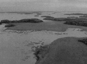
Site: MacDougal Point Peninsula CR
Location: Okikodosik Narrows
Aerial Photo by B. Burkhardt, Sept 06, 2002
Photo of the North end of Okikodosik Narrows from the north end looking south into Abitibi Lake and its many islands. Shown is a wetland complex of open water marsh, meadow marsh, shore fen, open bog and thicket swamps. Perfectly round bulrush circles are found in the water (not part of site).
7.0 References
Abraham, Ken. 2003. Personal Conversation.
Boissonneau, A.N., 1968. Timiskaming and Nipissing. Surficial Geology; Cartography by Lands and Surveys Branch.
Burkhardt, B.C. 2002. Aerial Reconnaissance Notes for C1714.
Bridge, S., R. Watt, G. Lucking and B. Naylor. 2000. Landscape analysis for forest management planning in boreal northeastern Ontario.
Crins, W.J. and P.W.C. Uhlig. 2000. Ecoregions of Ontario: Modifications to Angust Hill’s Site Regions and Site Districts Revisions and Rationale.
Geomatics International. 1994. CCEA Case Studies on Ecoregions Gary Analysis: Proposed Methodology for Determination of Representatives. Report prepared for the Canadian Council on Ecological Areas.
Hills, G.A. 1959a. A Ready Reference to the Description of the Land of Ontario and its Productivity.
Hills, G.A. 1959b. Hills Mapping.
Kor, P.S.G. 2003. Earth Science Planning Summary MacDougal Point Peninsula (C1714) Conservation Reserve and aerial landform/surficial material interpretation.
Ministry of Citizenship, Culture and Recreation. 1997. Archaeology, Land Use Planning & Development in Ontario: An Education Primer and Comprehensive Guide.
NTS topographic mapping (32 D/NW).
OFRI. 1994a. Boreal East Landforms Mapping Satellite Imagery.
Ontario Ministry of Natural Resources. 2003. Silvicultural Treatment Assessment and Reporting System (STARS): Background and Field Manual.
Ontario Ministry of Natural Resources. 1:20 000 1986. 1994 Air Photos.
Ontario Ministry of Natural Resources. 1983. Kirkland Lake District Land Use Guidelines.
Ontario Ministry of Natural Resources. 1995. Forest Resource Inventory Mapping (Ages Corrected).
Ontario Ministry of Natural Resources. 1997c. Ontario Watershed Mapping.
Ontario Ministry of Natural Resources. 1973. Strategic Sensitive Areas and Features. Northern Region MNR binder.
Ontario Ministry of Natural Resources. 1992. Ontario Provincial Parks: Planning and Management Policies 1992 Update.
Ontario Ministry of Natural Resources. 1999. Ontario’s Living Legacy Land Use Strategy. Queens Printer for Ontario, Toronto, ON.
Ontario Ministry of Natural Resources. Lakes 1:600 000 Mapping.
Ontario Ministry of Natural Resources. MTO Roads 1:600 000 Mapping.
Ontario Ministry of Natural Resources. Patent 1:600 000 Mapping.
Ontario Ministry of Natural Resources. Railway 1:600 000 Mapping.
Ontario Ministry of Natural Resources. Townships 1:600 000 Mapping.
Ontario Ministry of Natural Resources. Transmission Lines 1:600 000 Mapping.
Poser, S. 1992. Report of the status of provincial parks in the site region and districts of Ontario. Ministry of Natural Resources Report.
Rowe, J.S. 1972. Forest Regions of Canada.
Silver, M. 2002. Natural Heritage Area Life Science Checksheet.
Gordon, R.B. 2003. Ground Reconnaissance Notes.
Appendix 1: Public consultation summary
SCI Public Consultation Summary (C1714)
| Date received | Client | Comment | Action taken | Date of response |
|---|---|---|---|---|
| 29-Aug-00 | #1 | Was happy with the boundaries and has no objections to the site or the boundary locations. | Confirmed with GIS Officer the boundaries and that the map the client had was the most up to date. | 29-Aug-00 |
| 30-Aug-00 | #2 | Individual felt the OLL ad inthe paper was lacking without a map and supplied little information with regards to permitted uses etc. | An explanation of the permitted uses was given verbally and the assurance that the mail out package (he was added) contained maps and explanations. | 30-Aug-00 |
| 08-Sep-00 | #3 | Client was concerned that the MNR will not be able to monitor and protect these new proposed protected areas because of the staff shortage. | She was sent a package of the 26 sites currently being proposed for OLL including maps and fact sheets. | 08-Sep-00 |
| 03-Oct-00 | #4 | Client phoned asking for information package. Client interested in the Lake Abitibi area, historically and future land use and designation | Package sent in mail. | 21-Sep-00 |
| 03-Oct-00 | #5 | Individual who is interested in the history of Lake Abitibi and area indicated that he was happy with the conservation reserve designation and it subsequently being named after MacDougal Point and the MacDougal family named after MacDougal Point and the | Letter of thanks for input and comments sent to individual. | 04-Oct-00 |
| 06-Oct-00 | #6 | Was not happy with consultation package or map sizes. Also was concerned with fishing and hunting in OLL sites. Also wanted information on roads and access to sites. | Explained that because of the variety of sizes of the sites that it is not possible to have both scale and paper sizes the same for all sites. Also, fishing and hunting could continue as it had in the past, as well that existing roads would continue to be available for access including maintenance and upgrading. | 23-Oct-00 |
| 18-Jan-01 | #7 | Wants Notification of final approval of sites, of any changes to trapping policies, is ok with no new trapper’s cabins on the sites. Individual was requesting the info on behalf of the Trappers Council. | Client was placed on the mailout list and provided with all policy information regarding the sites. | 18-Jan-01 |
| 08-Feb-01 | #8 | Requested maps and some info regarding all OLL sites, as he was speaking on behalf of a snowmobile club. He was asking about trails and development of new trails for the purpose of snowmobiling. | He was sent, via mail, info on existing and new trails, as well as provided with the strategy and all 26 site maps. | 08-Feb-01 |
| 08-Apr-01 | #9 | Request on behalf of the Ontario Recreational Canoeist Association (ORCA) to be put on the mail out list for the sites that its members had an interest. | Letter of acknowledgement. | 09-Apr-01 |
| 18-Jan-02 | #10 | Wanted to know if there were any changes from previous correspondence on OLL sites (Bear Management Areas). Was also interested in updated maps for comparison. | Advised client that there is a website regarding OLL. Forwarded copy of permitted uses for OLL sites. | 18-Jan-02 |
| 18-Jan-02 | #11 | Requested better maps showing boundaries of OLL sites. | Sent email with web address for OLL. | 18-Jan-02 |
| 27-Jan-02 | #12 | Client had questions regarding forest reserves within conservation reserves. Also had questions on mining activities in OLL sites. | Explained that no information specifically on forest reserves was in the report. Forwarded sections on natural heritage stewardships to help answer any questions. Also sent info on mining interest. | 28-Jan-02 |
| 29-Jul-02 | #13 | Requested maps showing boundaries of OLL sites Fact sheets and LUS on behalf of Ducks Unlimited. Also had a question regarding planting wild rice in the Montreal River. | Sent maps showing boundaries of OLL sites Fact sheets and a copy of the LUS. As Montreal River is in a regulated park client would have to talk with Ontario Parks. | 29-Jul-02 |
| 10-Jun-03 | #14 | Received a letter from the Wahgoshig First Nation stating they have no concerns with the boundaries of the sites near their reserve. They would be interested in being included during the planning process for the C1714 site. | Letter of acknowledgement. | 11-Jun-03 |
| 12-Jan-05 | #15 | Received phone call from member of the Fish and Wildlife Advisory Committee, he was interested in receiving a copy of the draft SCI for C1714, among others, for review. | Package sent containing copies of draft Statements of Conservation Interest. | 13-Jan-05 |
Appendix 2: Public consultation ad
Review of draft statements of conservation interest
C1596 Whitefish River Sandy Till
C1602 Whitefish and East Whitefish Lakes Sandy Till Uplands
C1626 South Grassy Lake Outwash
C1714 MacDougal Point Peninsula
The Ministry of Natural Resources (SCI) for the Whitefish River Sandy Till, Whitefish and East Whitefish Lakes Sandy Till Uplands, South Grassy Lake Outwash and MacDougal Point Peninsula Conservation Reserves. Copies of these draft documents will be available for review at the Kirkland Lake District MNR office until February 21st, 2005.
The Whitefish River Sandy Till Conservation Reserve is situated 18 km northwest of the town of Matachewan. This Conservation Reserve is located within the townships of Cleaver, McNeil, Hincks, Argyle and Bannockburn and is 3,399 hectares in size. The Whitefish and East Whitefish Lakes Sandy Till Uplands Conservation Reserve is situated 20 km north of Matachewan and approximately 65 km west of the town of Kirkland Lake. This Conservation Reserve is located within Robertson, Baden, Sheba, Alma and Michie townships and is 9,353 hectares in size. The South Grassy Lake Outwash Conservation Reserve is found 17 km southeast of Kirkland Lake. This Conservation Reserve is located within McElroy and Hearst Townships and is 425 hectares in size. The MacDougal Point Peninsula Conservation Reserve is located 65 km north of Kirkland Lake and 45 km east of Iroquois Falls, in Rand, Frecheville and Stoughton townships. This Conservation Reserve is 6,035 hectares in size.
The Statements of Conservation Interest identify area values and provide direction on resource management activity and appropriate land uses. As conservation reserves, commercial activities such as forest harvesting, mining and hydroelectric power development are prohibited from occurring within the protected area. The Ministry of Natural Resources (MNR) is collecting comments and information regarding the draft Statements of Conservation Interest under the authority of the Public Lands Act (1990) to assist in making decisions and determining future public consultation needs. Comments and opinions will be kept on file for use during the plan’s operating period and may be included in the study documentation, which is made available for public review.
Under the Freedom of Information and Protection of Privacy Act (1987) personal information will remain confidential unless prior consent is obtained. However, this information may be used by the Ministry of Natural Resources to seek public input on the other resource management surveys and projects. For further information on this Act, please contact Shaun Walker at (705) 568-3231.
If you would like additional information or would like to supply background information or viewpoints to be considered by the planning team, please contact:
Jessy Malone or Jody Bissett
Land Use Planners
Ministry of Natural Resources
Kirkland Lake District
P.O. Box 910, 10 Government Road East
Kirkland Lake, ON
P2N 3K4
Phone: (705) 568-3253
Fax:
Comments will be accepted until February, 21st, 2005
Renseignement en francais : (705) 568-3222
Appendix 3: Recreational inventory checksheet
MacDougal Point Peninsula Conservation Reserve C1714
Recreational Inventory Report
July 24, 28 & Aug 06, 07 & Sept 05, 2003
Rick Gordon & Jennifer Telford
C1714 MacDougal Point Peninsula Conservation Reserve
Comments:
The MacDougal Point Peninsula Conservation Reserve is located approximately 65 km northeast of the Town of Kirkland Lake and 45 km east of the Town of Iroquois Falls. The conservation reserve is found within Rand, Frecheville and Stoughton townships in Kirkland Lake MNR District with Kirkland Lake MNR assuming responsibility for the site and in an unnamed township in Cochrane MNR District. The site is made up of 6 blocks separated by land and Lake Abitibi and occupies an area of 6,035 hectares. The sites can be accessed by boat on Lake Abitibi (M05) or by several forestry roads/trails (T00). The six blocks representing the MacDougal Point Peninsula Conservation Reserve are as follows MacDougal Point, the Narrows, Swampy Creek, Lightning Point, Okikodosik Narrows and Teddy Bear Marsh, all in the south portion of Lake Abitibi.
The MacDougal Point Peninsula Conservation Reserve is located in the Northern Clay (B.4) section of the Boreal Forest (Rowe 1972). Endless stretches of black spruce (P. nigra) (E03) cover gently rising uplands or lowland flats, the latter alternating with sedge fens and bogs (E08). Extensive areas of spruce-cedar (Picea mariana/Thuja occidentalis) also occur but cedar only reaches full size at swamp borders. Mixedwoods of trembling aspen (Populus tremula) (E04), balsam poplar (Abies balsamea/Populus) (E05), balsam fir (Abies balsamea), white spruce (P. alba) and black spruce (P. nigra) can be found on improved drainage areas such as on coarse drift beside rivers and lakes. Other tree species exist in this section but are not represented on the conservation reserve.
The conservation reserve is in the site region (Ecoregion) of Lake Abitibi (3E-6) which is characterized by moderately broken plains of grantic and lowbase bedrock (J06) generally covered by deep deposits of clay, silt and sand with locally extensive peat and wetlands (E08). Regional vegetation includes good stands of spruce (Picea mariana), poplar (Populus) and birch (B. alba) (E4) on fresh sites on moderately sloping terrain, white (P. Strobus) and red pine (P. resinosa) (E3) on sand ridges and American elm (Americana ulmus) and white cedar (Thuja occidentalis) (E3) in protected areas. Grey wooded soils and brown wooded soils are common on well-drained portions of limy clay and silt plains (J16) with peat and peat-gley soils occupying over 80% of these areas. Weakly developed boreal brown wooded and pod sols are common on the deep sands and rocky areas covered with light textured materials. Forest climate type is mid-humid, mid boreal (Hills 1959; Poser 1992). Old growth is dominant on MacDougal Point and the Narrows and can be found north of Teddy Bear Marsh.
The site blocks are located adjacent to Lake Abitibi, the 5th largest inland lake in Ontario (M05). The current composition of Lake Abitibi is typical shallow, turbid, warm water fisheries. Fish species present are walleye (Stizostedion vitreum), northern pike (Esox lucius), yellow perch (Perea flavescens), lake whitefish (Coregonus Labradoricus), goldeye (H. tergisus), sauger (Stizostidion canadense), lake sturgeon (Acipenser rubicundus), freshwater drum (Aplodinotus grunniens), white sucker (Echeneis Remora), brown bullhead (U. Richardsoni), burbot (L. maculosa) and others (A01). In addition, when lake waters are in low conditions there are beaches (B15) located along the shores of the sites.
The wetlands (E08) associated with the Lake Abitibi region can be attributed to the damming of the Lake Abitibi Reservoir by Abitibi Price at Twin Falls. Wetlands (Map 3b) are a dominant feature of the conservation reserve and account for almost 20% (not including forested swamps) of the area. Types include open water marsh (pond/water lily, tapegrass, pondweed, milfoil/coontail), meadow marsh (mostly sedges), poor fen/open bog (low shrub), treed bog to intermediate conifer swamp (black spruce), treed fen (tamarack) and rich conifer swamps (cedar). The most interesting feature of the wetlands is the perfectly round circles of bulrush in different shades of green found in Swampy Creek, Teddy Marsh and just north of the Okikodosik Narrows block (Map 3a). Ken Abraham (2003), a MNR wildlife/wetlands specialist, suggested it is a normal phenomenon where each circle represents growth from rhizomes of a single plant (cloning) in situations of narrow tolerances for other species or in response to stress such as water fluctuations.
Soils in many of the bays of the marshlands are predominantly black humics over silty clay mineral soils. Emergent aquatic vegetation (JOS) found in the adjacent marshlands to Lake Abitibi is limited in diversity and distribution. Substantial areas within the many bays are devoid of emergent vegetation (E14). Emergent vegetation that is found, usually close to shore or in protected areas consist of cattail (Typha sp.), spikerush (Eieocharis sp.), blue-joint grass (Calamagostis canadensis), burreed (Spaaganium sp.), bulrush (Scirpus sp.), arrowhead (Saggitaria sp.), horestail (Equesitum sp.), and wild rice (Zizania sp.). The wildrice growing in the marshland systems are usually found within a couple of bays with the exception of Teddy Bear Marsh were it is found more predominately. Sub emergent aquatic vegetation is found throughout the many bays and consists of pondweeds (Potamogaeton sp.), lilypads (Nuphar sp.), floating leaf-burreed (Sparaganium fluctuans), coontail (Ceratophyllum demersum), bladderwort (Uitricularia sp.), and milfoil (Myriophyllum sp.). The distribution of submergent plants within the wetland systems is very good and provides waterfowl with excellent foraging zones.
Several of these wetlands serve as important wildlife habitats. The Teddy Bear Marsh, just west of a major flyway (migratory corridor), is an excellent site for nesting and resting points for migratory birds (mainly waterfowl) (A03). The attractiveness of this marsh would not be possible if it were not for the dam (X) built at the outlet of the marsh. In 1984, Ducks Unlimited, in an agreement with MNR, built a dam and fish ladder (X) for northern pike (to access their traditional spawning area) in order to reduce the water level fluctuations experienced on Lake Abitibi. The marsh with its abundant aquatic vegetation provides moose with high or very high quality moose aquatic feeding areas. The wetland on the east side of Lightning Point has important waterfowl nesting habitat. Kechewajg Creek, west of MacDougal Point, also has excellent waterfowl nesting habitat as well as good moose aquatic feeding areas (OMNR 1999). Swampy Creek and the creeks at Okikodosik Narrows have potential to be good northern pike spawning and/or moose aquatic feeding areas. The number of moose (W03) observed during aerial inventory substantiates the quality of moose habitat.
Water levels are continually fluctuating as a result of dams on Abitibi River. Shorelines consist of either silty clay or bedrock outcrops. The lake is also important for bird colonies. There are several heronries, a double crested cormorant colony (observed in the Swampy Creek block (Burkhardt 2002)), osprey nests, etc. Within the Narrows and MacDougal Point blocks are two historical/archaeological sites. On the northeast corner of MacDougal Point was a Hudson Bay Trading Post (C03) operated by a man named Biederman and an Indian burial ground (C03) in the site. Along the Narrows is an archaeological site of continental significance for the Abitibi Narrows Shield Archaic peoples (OMNR 1999) (C04).
MacDougal Point
Consists of semitreed bog, treed bog/intermediate conifer swamp and treed fen or rich conifer swamps which were found on three landforms units. The dominant (accounts for almost half of the site) formation was old cedar and black spruce lowlands on mostly glaciolacustrine deposits. As in Lightning Point, this block is influenced by the moderating effects of Lake Abitibi and perhaps more so since it is greatly exposed to the north and south portion of the lake. Erosion, deposition and fluctuating water levels control the shoreline diversity. It also has good diversity in the different wetlands, ranging from open water marshes, cattail marshes to poor fen/open bog to treed bogs to conifer swamp. It also has good age structure, ranging from immature (harvested) stands to mature stands in the south and north portions to old growth along the west side.
Teddy Bear Marsh
Teddy Bear Marsh has a good representation of forest communities ranging from white birch hardwood mixed to black spruce mixedwood but is dominated by meadow and cattail marshes. The block consists of fairly evenaged (mature) mixedwood spruce fir on glaciolacustrine deposits with some representation from poplar and white birch. The other dominant formations are marshes (meadow and cattail) and water (open water marsh) on organic deposits. Teddy Bear Marsh also contains within the open water marsh some established bulrush circles and in another area some new circle formations. The marsh has low species diversity (dominated by sedges with some low shrubs) but good edge effects. All the little bays in the marsh increase the surface area and provides good habitat for waterfowl. Dispersion of forest communities is low. Mixedwood is concentrated around most of the marsh with poplar and white birch located in pockets in each corner of the block. The marsh as defined by vegetative boundaries, and measures approximately 2005 hectares. It has formed at the confluence of two watercourses (D01) which in turn flow into the Mattawasaga River emptying into Lake Abitibi. Remnant dead trees along the near shore zone suggest the area was originally a low lying timber swamp. Presumably, high lake levels created through dam construction at the outlet of Lake Abitibi resulted in a vegetative shift toward a more aquatic community. Presently the Marsh consists of a mixture of anchored and floating organic mat bordering a shallow water and river channel. The mat and open water zones occur in roughly equal proportions. Vegetation on the mats, in approximate order of abundance, includes sedges, cattail, horsetail, spikerush, buckbean, alder and willow. Burreed, hardstem bulrush, water lilies, spikerush, wildrice and arrowhead are the most commonly occurring emergent and floating species found in the shallow water areas. Fish species within the marsh and river system include Northern Pike, Suckers, Walleye, Whitefish, Perch, Bullhead and Mooneye (observed during fish migration project program in 1994).
Lightning Point
This block is dominated by immature poplar communities of mixedwoods, predominant hardwoods and hardwood mixed on mostly glaciolacustrine deposits with some pockets of bedrock-drift complex and bedrock outcrops along the shoreline. Outcrops are the result of the lake actions on the point. An arm of immature balsam fir conifer mixed occurs on glaciolacustrine deposits. The different wetland communities and black spruce lowland occur on organic deposits. The whole block is influenced by moderating effects of Lake Abitibi. Shoreline erosion and deposition has created alternating silt/clay and bedrock shorelines as well as small bays to create more edge. A thin beach ridge near the south edge has isolated the wetland (poor fen/open bog) from water exposure.
The Narrows
This block is different from the rest in that the wetlands do not play a significant role and bedrockcontrolled ridges (B26) with extensive sediment cover form the primary landform (Kor 2003). This block is moderately skewed towards immature spruce/fir on glaciolacustrine deposits, and mature spruce/poplar and immature spruce/fir on bedrock outcrops. Features that would increase diversity include bedrock outcrops which were visible during the aerial survey but most were not able to be mapped and the fairly even distribution of old growth, mature stands and immature stands (due to harvesting). This block represents an area northeast of the narrows that connect the north and south basins of Lake Abitibi. The narrows is a deep (averaging 40 to 100 foot) channel (M14) connecting the north and south lake basins which are shallow with average lake depths of 8 to 12 feet. The shoreline boundary of the narrows block consists of rock face (J07) of varying heights that would be excellent for cliff jumping.
Swampy Creek
The site is dominated by open muskeg (meadow marsh complex), mature Tamarack and water (open water marsh) on organic deposits, accounting for a little more than 50% of the block area total. An interesting feature that adds to the diversity of the block is the bulrush circles that appear in several locations of Swampy Creek. These circles appear to be uncommon based on all the aerial surveys conducted in the MNR Northeast Region. The only other conservation reserve locations were these circle formations appear were in Echo Bay and the mouth of the Spanish River, both east of Sault Ste. Marie. The many small bays in the meadow marsh complex increase the edge effect and provides good habitat for waterfowl and perhaps northern pike spawning areas.
Okikodosik Narrows
Open muskeg (marsh complex) on organic deposits is the dominant feature of the block. The site is also dominated by immature poplar and immature spruce/fir on glaciolacustrine deposits and poplar. Small islands of bedrock-drift complex and glaciolacustrine deposits within the marsh add to the diversity of the site. The edge effect is not so pronounced on the meadow marsh as in Teddy Bear Marsh or Swampy Creek but the complex has good diversity of different wetland types. Forest stand age does not add to the diversity of the site. Most of the block is immature with some mature poplar along the north creek.
The majority of the wetland sites are derived from an organic surface (J05) consisting of bogs, fens, swamps or marshes. These areas are habitat for moose (W03), and also aquatic birds such as ducks and herons (A03), which were spotted on a recent aerial reconnaissance survey. There are waterfowl staging areas in abundance on Lake Abitibi. The characteristics of the wetland areas make this conservation reserve an excellent site for bird watching (q10) and nature study (n05). Land use in the general area includes camping (k00), boating (b01), fishing (f00), hunting (h00), trapping (h06), forestry (in surrounding areas), and mineral exploration (in general area). One Bear Management Area (BMA) (h01) is contained within the site as well as four active traplines (h06). Waterfowl hunting is also a recreational activity of this area (h05). A private boat cache and duck boxes were found in the Teddy Bear Marsh parcel. A hunting blind was also spotted near the wetland on MacDougal Point. This site, as well as Lake Abitibi, is historically accessed during the winter by snowmobile (d10) and the summer by boat (b01) for the purpose of fishing (f00). There are no Mining claims/leases found within the conservation site blocks.
Based on the aerial survey, the conservation reserve disturbance level could be rated as medium. Most of the disturbance was manmade and included harvesting and water level fluctuations. Every block was affected by some form of harvesting, whether it was clearcut or selective harvest. In either case, good regeneration (either natural or artificial) has occurred. There are several roads/trails, more notably in Lightning Point and Okikodosik Narrows, which were created during the harvesting period. Several power generating dams exist along Abitibi River, the closest being Twin Falls and Iroquois Falls generating stations, that cause fluctuating water levels on Lake Abitibi and as a result determine the type of wetland community within each block. Teddy Bear Marsh was spread this with the dam/dyke structure built by Ducks Unlimited to control water levels. Fluctuating water levels also increase erosion on the silty clay shorelines and have an impact on spawning activity.
The conservation reserve is located in four trapline areas; KL005, KL012 in Kirkland Lake District and CC54, CC55 in Cochrane District. The MacDougal Point block does not belong to any trapline areas although, with its proximity being adjacent to a First Nation Reserve it is likely that active trapping occurs. The wetland ecosystems in this conservation reserve are sensitive to both recreation and resource development. Future uses of the conservation reserve should take into consideration the sensitivity of the natural values in any future planning initiative. All existing roads and trail networks not already mapped should be using the latest satellite (e.g. GPS) and computer (e.g. GIS) technologies. Mapped routes on Lake Abitibi date back to the 19th century depicting traditional use (H04) water routes (TO5) for logging operations.
All features within the conservation reserve are quite abundant with the exception of the following waterfowl/bird species. The Conservation reserve and associative waterbodies support a heronry, osprey nesting areas and several cormorant colonies, which suggests the W00 General Wildlife pick as the scarcest feature. As these types of fowl are not common in this area the feature scarcity would be very high. The most unique feature to the six blocks that make up the reserve is the large shallow lake Abitibi. With the numerous and varied quantities of sport fish available in the lake activity attractiveness is very high both in summer and winter months. Scenic attractiveness of the blocks due to the variety of wildlife and supporting habitat of the sites would be very high. Geographic significance based on the 5th largest shallowest lake in Ontario and the unique land forms associated with the lake and marshes would be very high. The most sensitive feature to recreational use is the wetland and marsh areas. The likeliest recreational use in the wetland and marshes would be from waterfowl/moose hunters and to a lesser degree canoe enthusiasts, trappers and fisher persons. Feature sensitivity to resource development is very high as water depth fluctuations from hydro projects, forestry next to associated water complex and any other resource development that could affect incoming water sources to the wetlands would have significant effect. Cultural/ Historic and Archeological features are present in the form of traditional use boat routes for past logging operations, Abitibi Narrows Archaic peoples and burial grounds and a Hudson Bay Trading post with traditional use canoe and trail routes.
Figure 12.0
Site: MacDougal Point Peninsula CR
Location: Okikodosik Narrows
Aerial Photo by B. Burkhardt, Sept 06, 2002
Photo of the North end of Okikodosik Narrows from the north end looking south into Abitibi Lake and its many islands. Shown is a wetland complex of open water marsh, meadow marsh, shore fen, open bog and thicket swamps. Perfectly round bulrush circles are found in the water (not part of site).
Lightning Point – wetland east shore
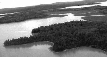
MacDougal Point – spruce bog
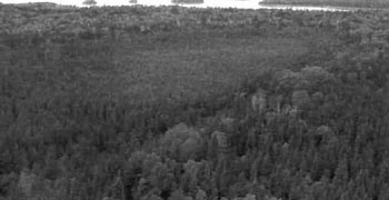
Parcel north of MacDougal Point
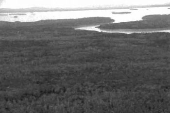
Teddy Bear Marsh
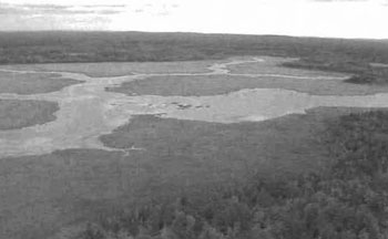
Swampy Creek north looking south
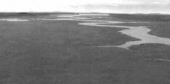
Swampy Creek southend of creek
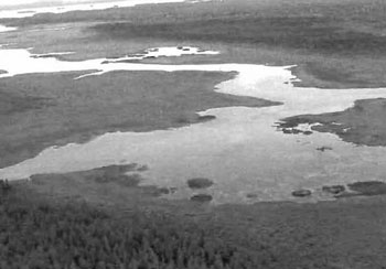
Okikodosic Narrows
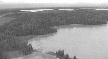
Okikodosic Narrows northend of site
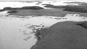
Appendix 4: Procedural Guideline B Land uses Test of compatibility (PL Procedure 3.03.05)
The Conservation Reserve policy provides broad direction with regard to the permitted uses. The policy provides only an indication of the variety of uses that will be considered acceptable in Conservation Reserves. The only caution is that “ any new uses, and commercial activities associated with them, will be considered on a case by case basis and, they must pass a test of compatibility to be acceptable.”
What does a “test of compatibility” mean? An examination of this must start from the premise of why an area is set aside specifically, its representative natural heritage values. Criteria are then identified to guide compatibility considerations. These criteria apply to the longterm acceptability of both existing uses and new uses.
- Conformity to SCI/RMP: SCI describes values for which an area has been set aside and the range of appropriate uses that will be permitted in the area. SCI may also speak to the acceptability of other ’new’ uses currently not occurring in the area.
The first “test” is: “do proposed new land uses and/or commercial activities conform to the direction of the SCI/RMP for the Conservation Reserve? Would the new use(s) depart from the spirit of appropriate indicator land uses in the SCI/RMP?”
-
Impact assessment: If the proposed use(s) pass test 1 it is important to determine their impact on the area before they are approved. This should include the following:
- Impact on natural heritage values: “will the new use(s) impact any natural values in the area? If so, how and to what degree? Is it tolerable?”
- Impact on cultural values:“will the new use(s) impact any historical or archaeological values in the area?”
- Impact on research activities: “will the new use(s) affect research activities in the area?”
- Impact on current uses: “will the new use(s) have any negative impact on the array of current uses?”
- Impact on area administration: “will the new use(s) increase administrative cost and/or complexity?” (For example, the cost of area monitoring, security or enforcement).
- Impact on accommodating the use outside the Conservation Reserve: “Could the use(s) be accommodated as well or better outside the Conservation Reserve?”
- Impact on socioeconomics of the area: “will the new use(s) affect the community (ies) surrounding the area in a positive or negative way?” (For example, will the new use make an area less remote thereby affecting a local tourism industry that is dependent on the area’s remoteness for its appeal?).
- Impact on area accessibility: “does the new use(s) give someone exclusive rights to the area or a portion of the area to the exclusion of other existing uses?”
Appendix 5: Procedural guideline C Research activities in conservation reserves
Purpose
To encourage contributions to the goal of conservation reserves by:
- Providing direction for research activities associated with conservation reserves: and
- Establishing a process for the review and approval of proposals by researchers, which could have an impact on the values protected by the conservation reserve.
Definition
Research means any investigation or study of the natural, cultural, social, economic, management or other features of characteristics of conservation reserves.
Guidelines
Research will be encouraged to provide a better understanding of the natural values protected by a conservation reserve and to advance their protection, planning and management. The Statement of Conservation Interest will define, for each conservation reserve, the key research issues, set out the parameters within which research may occur and identify research needs.
Applications and approvals
Researchers must apply in writing to the Area Supervisor for permission to conduct research. The request letter must contain a statement explaining why the proposed research should be undertaken in the particular conservation reserve in preference to another location.
Proposals will be reviewed and approved by the Area Supervisor, guided by the Statement of Conservation Interest prepared for each reserve (See Guideline A Resource Management Planning) and using Guideline B Land Uses Test of Compatibility. Permission must be granted in writing, including any conditions to be met in conducting the research, prior to the undertaking of any research project.
Terms and conditions
Permission to conduct research under this policy will be valid for a period of 12 consecutive months from date of issue. Permission to continue a research project for additional periods of 12 months or less may be granted upon submission of a written request and progress report. The Ministry may require the posting of collateral to assure that the terms and conditions of granting permission are to be met.
The Area Supervisor may suspend or revoke permission at any time for failure on the part of the researcher to meet:
- The intent or conditions of this policy.
- The requirements under the Public Lands Act, including all amendments, where applicable.
- The requirements under any other Act or Regulations or Ontario or Canada, including those governing the taking, handling, storing, confining, trapping, excavating and marketing any specimen, artifact, information or action (for example, scientific collector’s permit).
- The conditions and agreements specified in granting permission.
Final report
The researcher will submit copies of reports, publications and theses following from the results of the project to the Area Supervisor.
Appendix 6: Crown Land Use Atlas policy report
C1714
MacDougal Point Peninsula
Updated: February 16, 2005
Crown Land Use Atlas
Identification:
ID: C1714
Area Name: MacDougal Point Peninsula
Area (ha): 6,036
Designation: Conservation Reserve Recommended (Ontario’s Living Legacy)
MNR District(s): Cochrane, Kirkland Lake
Description:
Located on MacDougal Point in Lake Abitibi, this site is representative of lacustrine deposit with mixed conifer forest, mixed deciduous forest, and sparse forest. It also includes 3 other land areas along the shoreline of Lake Abitibi.
Land use intent:
The intent is to regulate this area as a conservation reserve.
Management of this area is also governed by the general policies in the Land Use Strategy (1999).
Management direction:
Those uses and management activities not listed in the following table are governed by existing conservation reserve policy. Over time the management direction will be elaborated in a Statement of Conservation Interest or Resource Management Plan. Any new uses, and commercial activities associated with conservation reserves, will be considered on a case by case basis, and they must pass a test of compatibility to be acceptable.
Compatibility is normally determined through a planning process.
Commercial activities
| Activity | Permitted | Guidelines |
|---|---|---|
| Aggregate Extraction | No | N/A |
| Bait Fishing Existing | Yes | Existing use permitted to continue, unless there are significant demonstrated conflicts. |
| Bait Fishing New | Maybe | New operations can be considered, subject to the “test of compatibility”. |
| Commercial Fishing Existing | Yes | Existing use permitted to continue, unless there are significant demonstrated conflicts. |
| Commercial Fishing: New | Maybe | New operations can be considered, subject to the “test of compatibility”. |
| Commercial Fur Harvesting Existing | Yes | Existing use permitted to continue, unless there are significant demonstrated conflicts. Existing trap cabins can continue; new cabins are not permitted. |
| Commercial Fur Harvesting New | Maybe | New operations can be considered, subject to the “test of compatibility”. |
| Commercial Hydro Development | No | N/A |
| Commercial Timber Harvest | No | N/A |
| Commercial Tourism Existing | Yes | Existing authorized facilities can continue, unless there are significant demonstrated conflicts. |
| Commercial Tourism New | Maybe | New tourism facilities can be considered during the planning for an individual reserve. |
| Bear Hunting by Nonresidents (guided) Existing | Yes | Existing authorized operations permitted to continue. |
| Bear Hunting by Nonresidents (guided) New | No | New operations not permitted. |
| Outfitting services Existing | Yes | Existing authorized operations permitted to continue. |
| Outfitting services New | Maybe | New operations can be considered during the planning for an individual reserve. |
| Outpost Camos Existing | Yes | Existing authorized operations permitted to continue. |
| Outpost Camos New | Maybe | New operations can be considered during the planning for an individual reserve. |
| Resorts/lodges Existing | Yes | Existing authorized facilities permitted to continue. |
| Resorts/lodges New | Maybe | New facilities can be considered during the planning for an individual reserve. |
| Energy Transmission and Communications Corridors Existing | Yes | These facilities should avoid conservation reserve lands wherever possible. |
| Energy Transmission and Communications Corridors New | No | These facilities should avoid conservation reserve lands wherever possible. |
| Food Harvesting (Commercial) Existing | Maybe | N/A |
| Food Harvesting (Commercial) Existing | Maybe | N/A |
| Mineral Exploration and Development | No | N/A |
| Peat Extraction | No | N/A |
| Wild Rice Harvesting Existing | Yes | N/A |
| Wild Rice Harvesting New | Maybe | N/A |
Land and resource management activities
| Activity | Permitted | Guidelines |
|---|---|---|
| Crown Land Disposition Private Use | Maybe | Sale of lands is not permitted, except for minor dispositions in support of existing uses (e.g. reconstruction of a septic system). Renewals of existing leases and land use permits are permitted. Requests for transfer of tenure will be considered in the context of the Statement of Conservation Interest or Resource Management Plan. New leases or land use permits permitted for approved activities. Tourism facilities can apply to upgrade tenure from LUP to lease. |
| Crown Land Disposition Commercial Use: | Maybe | Sale of lands is not permitted, except for minor dispositions in support of existing uses (e.g. reconstruction of a septic system). Renewals of existing leases and land use permits are permitted. Requests for transfer of tenure will be considered in the context of the Statement of Conservation Interest or Resource Management Plan. New leases or land use permits permitted for approved activities. Tourism facilities can apply to upgrade tenure from LUP to lease. |
| Fire Suppression | Yes | Fire suppression policies are similar to adjacent Crown lands, unless alternative fire policies have been developed through a planning process. |
| Fish Habitat Management | Maybe | N/A |
| Fish Stocking | Maybe | Conservation Reserves policy indicates that “featured species management” may be permitted. |
| Insect/disease Suppression | Maybe | N/A |
| Inventory/Monitoring | Yes | N/A |
| Prescribed Burning | Maybe | N/A |
| Roads (Resource Access): Existing | Yes | Existing roads can continue to be used. Continued use will include maintenance and may include future upgrading. |
| Roads (Resource Access): New | Maybe | New roads for resource extraction will not be permitted, with the exception of necessary access to existing forest reserves for mineral exploration and development. |
| Vegetation Management | Maybe | Conservation Reserves policy indicates that Featured Species Management and Natural Systems Management may be permitted. Vegetation management can be considered in a planning process. |
| Wildlife Population Management | Maybe | N/A |
Science, education and heritage appreciation
| Activity | Permitted | Guidelines |
|---|---|---|
| Collecting | No | N/A |
| Historical Appreciation | Yes | N/A |
| Nature Appreciation | Yes | N/A |
| Photography and Painting | Yes | N/A |
| Research | Yes | N/A |
| Wildlife Viewing | Yes | N/A |
Recreation activities and facilities
| Activity | Permitted | Guidelines |
|---|---|---|
| Allterrain vehicle use: On trails | Yes | Existing use permitted to continue where it does not adversely affect the values being protected. ATV use off trails is not permitted except for direct retrieval of game. |
| Allterrain vehicle use: Off trails | No | ATV use off trails is not permitted except for direct retrieval of game. |
| Campgrounds | Maybe | N/A |
| Food Gathering | Yes | N/A |
| Horseback Riding (trail) | Yes | Existing use on trails permitted. |
| Hunting | Yes | N/A |
| Mountain Bike Use | Yes | Existing use on trails permitted. |
| Motor Boat Use: Commercial | Yes | N/A |
| Motor Boat Use: Private | Yes | N/A |
| Nonmotorized Recreation Travel | Yes | N/A |
| Private Recreation Camps (Hunt Camps): Existing | Yes | Existing camps permitted to continue, and may be eligible for enhanced tenure, but not purchase of land. |
| Private Recreation Camps (Hunt Camps): New | No | Existing camps permitted to continue, and may be eligible for enhanced tenure, but not purchase of land. |
| Rock Climbing | Maybe | N/A |
| Snowmobiling: On trails | Yes | Except for the direct retrieval of game. |
| Snowmobiling: Off trails | No | Except for the direct retrieval of game. |
| Sport Fishing | Yes | N/A |
| Trail Development: Existing | Yes | Development of trails for a variety of activities (e.g. hiking, crosscountry skiing, cycling, horseback riding, snowmobiling) can be considered as part of planning for an individual reserve. |
| Trail Development: New | Maybe | Development of trails for a variety of activities (e.g. hiking, crosscountry skiing, cycling, horseback riding, snowmobiling) can be considered as part of planning for an individual reserve. |
Note: The policies outlined in this table do not supersede any Aboriginal or treaty rights that may exist, or other legal obligations.
Source: Ontario’s Living Legacy Land Use Strategy, Table 4, and Conservation Reserves Policy.
Management of this conservation reserve is carried out within the context of Conservation Reserve policy as amended by the policies for new conservation reserves outlined in the Ontario’s Living Legacy Land Use Strategy.
Source of direction:
Ontario’s Living Legacy Land Use Strategy (1999)
Explanation of edits:
Area calculation has been edited based on current mapping. Area calculations are preliminary until public consultation on boundaries has been completed and the area has been regulated.
Appendix 7: Locator map
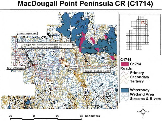
Appendix 8: Natural heritage life science checksheet
- Name: C1714 MacDougal Point Peninsula CR
- Map Name: Lightning River
Aylen River - Map Number: 32D/12, 32D/13
- UTM Ref.: 592539
- Locality: Cochrane
- Lat.: 48°40′38″N
- Long.: 79°45′00″W
- NAD: 83 CNT
- Min. Alt.: 270m
- Max. Alt.: 310m
- Township: Rand, Frecheville, Stoughton, unnamed
- Area: 6036 ha
- Ownership: Crown
- MNR Region: Northeast
- MNR District: Kirkland Lake
- Ecoregion and ecodistrict: 3E-3, 3E-6 (Hills 1959); 3E-6 (Crins 2000)
- Landform Unit(s): 9/6b Organic Deposit over Glaciolacustrine Deposit (silt and clay)
9 Organic Deposit unsubdivided
6c Glaciolacustrine Deposit (gravel, gravelly sand &/or sand)
6b Glaciolacustrine Deposit silt and clay
2d Bedrock Drift Complex (drift cover thin, but relatively continuous)
2 Bedrock Drift Complex unsubdivided
1 Bedrock Outcro unsubdivided - Aerial Photographs: Year-Flight Line-Roll Numbers
1986-4819-12-196 to 197
1986-4820-12-220 to 222
1986-4821-12-140 to 142
1994-4822-15-133 to 134
1986-4822-12-116 to 118
1994-4823-15-98 to 100
1986-4823-12-162 to 164
1986-4824-12-84 to 85, 89 to 91
1986-4825-36-63 to 65, 68 to 69, 75 to 76
1986-4826-26-33 to 35, 88 to 89
MacDougal Point Penninsula Conservation Reserve
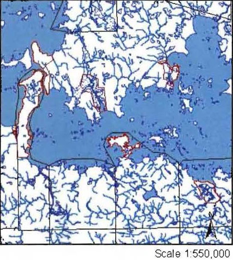
Physical and biological features
Representation
MacDougal Point Peninsula Conservation Reserve is located in the Townships of Rand, Frecheville and Stoughton in Kirkland Lake MNR District with Kirkland Lake MNR assuming responsibility of the site and in an unnamed township in Cochrane MNR District. It is located approximately 65 km north of the town of Kirkland Lake and 45 km east of the town of Iroquois Falls and can be accessed by boat on Lake Abitibi or by several forestry roads/trails. The site is 6036 hectares in size and is composed of six blocks on MacDougal Point, the Narrows, Swampy Creek, Lightning Point, Okikodosik Narrows and Teddy Bear Marsh, all in the south portion of Lake Abitibi.
The conservation reserve is in the Site Region (Ecoregion) of Lake Abitibi (3E) which is characterized by moderately to gently rolling bedrock, generally covered by deep deposits of clay, silt and sand with locally extensive peatlands and wetlands. Regional vegetation includes good stands of spruce, poplar and birch on fresh sites on moderately sloping terrain, white and red pine on sand ridges and American elm and white cedar in protected areas. Grey wooded soils and brown wooded soils are common on well-drained portions of limy clay and silt plains with peat and peat-gley soils occupying over 80% of these areas. Weakly developed boreal brown wooded and podsols are common on the deep sands and rocky areas covered with light textured materials. Forest climate type is mid-humid, mid-boreal (Hills 1959; Poser 1992). The conservation reserve was originally in Hills’ site Districts of 3E-3 (Cochrane) and 3E-6 (Kirkland Lake). With Grins (2000) new boundary interpretation, the conservation reserve is entirely in Ecodistrict 3E-6. This Ecodistrict is characterized by moderately broken plains of granitic and lowbase bedrock generally thinly covered with granitic and lowbase sand and silty sand. Glaciofluvial sand and gravel trains also occur. Soils are composed of podsols and boreal brown podsolics on better drained uplands and peats and peat gley on poorly drained material (Hills 1959).
According to the provincial landform coverage, the conservation reserve is covered entirely with lacustrine deposits (Map1b). This is in accordance with Kor’s (2003) interpretation. Most of the blocks are dominated by glaciolacustrine deposits of silt and clay (Unit 6b) except for the Swampy Creek and Teddy Bear Marsh blocks which are dominated by organic deposits (unit 9). These glaciolacustrine deposits are of Barlow-Ojibiway Lake origin. Minor areas of bedrock outcrop, composed primarily of igneous intrusive and metavolcanic rocks (Unit 1), occur on the Lightning Point and the Narrows blocks. Other landforms include bedrock-drift complex (either unsubdivided or with continuous drift cover) (Unit 2, 2d) which was found mostly on the Okikodosik Narrow and the Narrows block and glaciolacustrine deposits composed of gravel, gravelly sand, and/or sand (Unit 6c) found on the Narrows block.
MacDougal Point Peninsula CR is located in the Northern Clay (B.4) section of the Boreal Forest (Rowe 1972). Endless stretches of black spruce cover gently rising uplands or lowland flats, the latter alternating with sedge fens and bogs. Extensive areas of spruce-cedar also occur but cedar only reaches full size at swamp borders. Mixedwoods of trembling aspen, balsam poplar, balsam fir, white spruce and black spruce can be found on improved drainage areas such as on coarse drift beside rivers and lakes. Other tree species exist in this section but are not represented on the conservation reserve.
The conservation reserve is dominated by Ce mixedwoods
Wetlands
Several of these wetlands serve as important wildlife habitats. The Teddy Bear Marsh, just west of a major flyway (migratory corridor), is an excellent site for nesting and resting points for migratory birds (mainly waterfowl). The attractiveness of this marsh would not be possible if it were not for the dam built at the outlet of the marsh. In 1984, Ducks Unlimited, in an agreement with MNR, built a dam and fish ladder for northern pike (to access their traditional spawning area) in order to reduce the water level fluctuations experienced on Lake Abitibi. The marsh with its abundant aquatic vegetation provides moose with high or very high quality moose aquatic feeding areas (Gordon 2003). The wetland on the east side of Lightning Point has important waterfowl nesting habitat. Kechewaig Creek, west of MacDougal Point, also has excellent waterfowl nesting habitat as well as good moose aquatic feeding areas (OMNR 1999). Swampy Creek and the creeks at Okikodosik Narrows have potential to be good northern pike spawning and/or moose aquatic feeding areas. The number of moose observed during aerial inventory substantiates the quality of moose habitat.
Lake Abitibi, the 5th largest inland lake of Ontario, is an important coolwater sport fishing waterbody. Fish species include northern pike, walleye, lake whitefish, goldeye, sauger, lake sturgeon freshwater drum, white sucker, brown bullhead, and burbot (Gordon 2003). Verify with District any important spawning areas.besides, Teddy Bear Marsh The lake is in the 4MA tertiary watershed of the Moose River major basin and is shallow and turbid. Water levels are continually fluctuating as a result of dams on Abitibi River. Shorelines consist of either silty clay or bedrock outcrops. The lake is also important for bird colonies. There are several heronries, double crested cormorant colony (of which one was observed in the Swampy Creek block (Burkhardt 2002)), osprey nest, etc. Within the Narrows and MacDougal Point blocks are two historical/archaeological sites. On the northeast corner of MacDougal Point was a Hudson Bay Trading Post operated by a man named Biederman and an Indian burial ground in the site. Along the Narrows is an archaeological site of continental significance for the Abitibi Narrows Shield Archaic peoples (OMNR 1999).
The conservation reserve is located in four trapline areas; KL005, KL012 in Kirkland Lake District and CC54, CC55 in Cochrane District. MacDougal Point does not belong to any trapline areas.
Condition
Condition refers to the amount of disturbance that the site has experienced and includes both human and natural disturbance. Based on the aerial survey, the disturbance could be rated as medium
Diversity
Diversity is the measure of the site’s life and earth heterogeneity. The evaluation is based on the number and range (variety) of the natural landscape features and landforms for earth science values and the relative richness and evenness of the site’s life science components. For this conservation reserve, the diversity is rated as medium
Diversity for the conservation reserve can be described as a whole or by the individual blocks. Since there is no uniformity between the blocks it is fitting to describe each block differently. In most cases, the diversity rating was low, with the exception of the Narrows, which had medium diversity. The blocks were split between moderately and strongly skewed landform:vegetation combinations.
Teddy Bear Marsh
Teddy Bear Marsh has a good representation of forest communities ranging from Bw hardwood mixed to Sb mixedwood but is dominated by meadow and cattail marshes. When SFU’s are considered, the diversity is greatly reduced. The block is dominated by fairly evenaged (mature) MW2 (spruce fir) on glaciolacustrine deposits (33.8%) with some representation from PO1 and BW1. The other dominant formations are marshes (meadow and cattail) (25.0%) and water (open water marsh) (10.8%) on organic deposits. In total, there were 32 landform:vegetation (L:V) combinations for 732 ha but with polygon slivers and areas accounting for less than 1%, the diversity score was reduced to 15 (Table 12). Three L:V’s were included into the total that were less than 1% in area and they include bedrock landforms (units 1 and 2) that are not common to the block. Teddy Bear Marsh also contains within the open water marsh some established bulrush circles and in another area some new circle formations. The marsh has low species diversity (dominated by sedges with some low shrubs) but good edge effects. All the little bays in the marsh increase the surface area and provides good habitat for waterfowl. Dispersion of forest communities is low. MW2 is concentrated around most of the marsh with PO1 and BW1 located in pockets in each corner of the block.
Lightning Point
Lightning Point has 20 L:V combinations in 527 ha but the total was modified to 7, thus creating a low diversity score (Table 13). It is dominated by immature Po communities of mixedwoods, predominant hardwoods and hardwood mixed on mostly glaciolacustrine deposits with some pockets of bedrock-drift complex (unit 2d) and bedrock outcrops (unit 1) along the shoreline. Outcrops are the result of the lake actions on the point. These Po communities were split into MW2 and PO1 (poplar). An arm of immature Bf conifer mixed (SF1) occurs on glaciolacustrine deposits. The different wetland communities and SB1 (black spruce lowland) occur on organic deposits. The whole block is influenced by moderating effects of Lake Abitibi. Shoreline erosion and deposition has created alternating silt/clay and bedrock shorelines as well as small bays to create more edge. A thin beach ridge near the south edge has isolated the wetland (poor fen/open bog) from water exposure.
MacDougal Point
MacDougal Point has the greatest diversity (but still rated low for its size) and dispersion of all the blocks with a total of 53 L:V combinations and a modified total of 20 L:V’s on 2375 ha (Table 14). SB1, PO1, LC1 and MW2 can be found in pockets throughout the block. SB1 (semitreed bog, treed bog/intermediate conifer swamp) and LC1 (treed fen or rich conifer swamp) were found on three landforms (units 9, 9/6b, 6b) units. The dominant (accounts for almost half of the site) formation was old SF1 (cedar and black spruce lowlands) on mostly glaciolacustrine deposits. As in Lightning Point, this block is influenced by the moderating effects of Lake Abitibi and perhaps more so since it is greatly exposed to the north and south portion of the lake. Erosion, deposition and fluctuating water levels control the shoreline diversity. It also has good diversity in the different wetlands, ranging from open water marshes, cattail marshes to poor fen/open bog to treed bogs to conifer swamp. It also has good age structure, ranging from immature (harvested) stands to mature stands in the south and north portions to old growth along the west side.
The Narrows
This block is different from the rest in that wetlands (aquatic) do not play a significant role and bedrockcontrolled ridges with extensive sediment cover form the primary landform (Kor 2003). There are 28 L:V combinations and a modified total of 21 L:V’s which rates the block as having medium diversity for 805 hectares (Table 15). Several L:V’s that were less than 1% in total area were added to the diversity total as they were found only this block. It included old SF1 on unit 6c and old MW2 on bedrock outcrops, and rock (FRI’s) on either bedrock-drift complex or glaciolacustrine deposits. This block is moderately skewed towards immature SF1 on glaciolacustrine deposits, and mature SP1 and immature SF1 on bedrock outcrops. Features that would increase diversity include bedrock outcrops which were visible during the aerial survey but most were not able to be mapped and the fairly even distribution of old growth, mature stands and immature stands (due to harvesting).
Swampy Creek
The Swampy Creek block has very low diversity for its size (31 L:V combinations in 1121 ha with a modified total of 14) (Table 16). The site is dominated by open muskeg (meadow marsh complex), mature LC1 and water (open water marsh) on organic deposits, accounting for a little more than 50% of the block area total. There is no old growth to add to the diversity but the SB1 harvested areas (immature) counteracts this. An interesting feature that was add to the diversity (L:V combination modified total) of the block is the bulrush circles that appear in several locations of Swampy Creek. These circles appear to be uncommon based on all the aerial surveys conducted in the MNR Northeast Region. The only other locations were in Echo Bay and the mouth of the Spanish River, both east of Sault Ste. Marie. The many small bays in the meadow marsh complex increase the edge effect and provides good habitat for waterfowl and perhaps northern pike spawning areas.
Okikodosik Narrows
This block has 32 L:V combinations and a modified total of 14 in 540 ha. Open muskeg (marsh complex) on organic deposits is the dominant feature of the block. The site is also dominated by immature PO1 and immature SF1 on glaciolacustrine deposits and PO1. Small islands of bedrock-drift complex and glaciolacustrine deposits within the marsh add to the diversity of the site. The edge effect is not so pronounced on the meadow marsh as in Teddy Bear Marsh or Swampy Creek but the complex has good diversity of different wetland types. Forest stand age does not add to the diversity of the site. Most of the block is immature with some mature PO1 along the north creek.
Ecological considerations
Wherever possible, the site’s boundaries should be created to include the greatest diversity of life and earth science features to provide the maximum ecological integrity. It should be ecological selfcontained, bounded by natural features and include adequate area to buffer the core ecosystems from adjacent land use activities (OMNR 1992). Each of the blocks has biological, cultural and vectored boundaries. Biological boundaries include the shorelines of Lake Abitibi, creeks and rivers and cultural boundaries include harvest roads and trails. By having Lake Abitibi as a biological boundary, the incidence of human activities (e.g. harvesting) encroachment is reduced. Only natural factors such as erosion will have an effect on the areas. Most of the vectored boundaries were added to the Narrows, Swampy Creek and Okikodosik Narrows blocks and in most likelihood created to add buffers to the core areas (Appendix 2 History Map). For the Narrows, it would have been better to use the roads and follow the lakeshore. In a sensitive area report, it was suggested that an 800-meter buffer be created along the Narrows to protect a significant archaeological site (OMNR 1973).
Currently we do not have minimum size standards for conservation reserves under different landscape conditions. However, a minimum size standard of 2000 ha has been established for natural environment parks by Ontario Parks (OMNR 1992). This minimum standard was considered necessary to protect representative landscapes as well as allow for low intensity recreational activities. The MacDougal Point Peninsula Conservation Reserve is over 6000 ha in size but the conservation reserve is divided into six separate blocks of which, except for MacDougal Point, are less than 2000 ha each in size. To add some integrity to the conservation reserve, a shoreline buffer on Lake Abitibi should be added to connect the individual blocks and create some link with P1622 (Lake Abitibi Islands Provincial Park).
Special features
There are several special features with C1714. First, the bulrush circles found in Swampy Creek (the most dominant site), Okikodosik Narrows (mostly outside the block) and Teddy Bear Marsh (some small ones but also some new formations) are an interesting phenomena. Another special feature is that every block is different from one another. MacDougal Point with its mostly swamp and bog wetlands, the Narrows with its lack of aquatic wetlands and bedrockcontrolled landforms, Swampy Creek with its many types of wetlands and bulrush circles, Okikodosik Narrows with its wetlands, trembling aspen and balsam fir forest communities, Teddy Bear Marsh with its large meadow marsh, the Ducks Unlimited dam/dyke/fish ladder and the variety of forest communities and Lightning Point with a little of everything.
Major information sources
Abraham, Ken. 2003. Personal conversation.
Arnup, R., G.D. Racey and R.E. Whaley. 1999. Training manual for photo interpretation of ecosites in northwestern Ontario. NWST Technical Manual TM003.127p.
Bridge, S., R. Watt, G. Lucking and B. Naylor. 2000. Landscape analysis for forest management planning in boreal northeastern Ontario. OMNR, Northeast Science and Technology. 36p.
Burkhardt, B.C. 2002. Aerial Reconnaissance Notes C1714.
Crins, W.J. 2000. Ecoregions of Ontario: Modifications to Angus Hills’ site Regions and Site Districts Revisions and Rationale.
Gordon, R. 2003. MacDougal Point Peninsula Conservation Reserve C1714. Recreational Inventory Report.
Gordon, R. 2003. Personal conversation.
Harris, A.G., S.C. McMurray, P.W.C. Uhlig, J.K Jeglum, R.F. Foster and G.D. Racey. 1996. Field guide to the wetland ecosystem classification for northwestern Ontario. Ont. Min. Natur. Resour., Northwest Sci. & Technol. Thunder Bay, ON. Field Guide FG01. 74 pp.
Hills, G.A. 1959. A Ready Reference to the Description of the Land of Ontario and its Productivity.
Kor, P.S.G. 2003. Earth Science Inventory Checklist.
Ontario Ministry of Natural Resources. 1973. Strategic Sensitive Areas and Features. Northern Region MNR binder.
Ontario Ministry of Natural Resources. 1992. Ontario Provincial Parks: Planning and Management Policies 1992 Update.
Ontario Ministry of Natural Resources. 1999. C1702 file. Internal document.
Ontario Ministry of Natural Resources. 1999. Ontario’s Living Legacy Land Use Strategy.
Ontario Ministry of Natural Resources. 2002. MNR Districts and Major Basins of Ontario.
Poser, S. 1992. Report on the Status of Provincial Parks in the Site Regions and Districts of Ontario. Ministry of Natural Resources Report.
Rowe, J.S. 1972. Forest Regions of Canada. Department of Fisheries and the EnvironmentCanadian Forestry Service Publication No. 1300. 172 p.
Taylor, K.C., R.W. Arnupd B.G. Merchant, W.J. Parton and J. Nieppola. 2000. A field guide to forest ecosystems of northeastern Ontario. 2nd Edition. Northeast Science and Technology NEST Field Guide FG001.
Thompson, J.E. & J. Noordhof. 2003. Edit Model for N.E. Region Life Science Checksheets. Internal report.
Uhlig, P., A Harris, G. Craig, C. Bowling, B. Chambers, B. Naylor and G. Beemer. 2001. Old growth forest definitions for Ontario. Ont. Ministry of Natural Resources, Queen’s Printer for Ontario, Toronto. ON. 27p.
Significance level (provincial/regional/local) and brief summary of major representative values
The OLL Land Use Strategy (1999) states the site is representative of lacustrine deposit with mixed conifer forest, mixed deciduous forest and sparse forest. In analysis, this statement was discovered to be true. The conservation reserve is dominated by glaciolacustrine deposits with some areas of bedrock-drift complex, organic deposits and a few outcrops. Forest communities are dominated by SF1 (equivalent to mixed conifer forest which includes Ce mixedwood, Bf conifer mixed, Sb predominant conifer, etc.), MW2 (equivalent to mixed deciduous which includes Bw hardwood mixed, Po mixedwood, etc.) and harvested areas and treed bogs which are equivalent to sparse forest. Wetlands (FRI) and water also play a significant role in the conservation reserve in that it accounts for almost 20% of the area. Wetlands included open water marsh, meadow marshes, shore fens, etc.
Sensitivity
The shorelines of Lake Abitibi and the wetlands (marshes, open water marsh) within Swampy Creek and Okikodosik Narrows and fish habitat can be affected by fluctuating water levels created by the hydro dam at Twin Falls.
Recommendations
- This fourth step checksheet should be advanced to a fifth step by comparing the fourth step checksheet with the current provincial landform layers based on the new regulated boundary to see if comparisons can be made. In turn we can determine more fully the site’s significance and contribution to the parks and protected areas program.
- The vectored boundaries for the site should be marked to ensure that the values within the site are protected from surrounding land use activities. Further analysis and assessment may require additional management prescription to ensure long term protection of the site’s natural heritage values.
- A management plan should be developed for Lake Abitibi to link the conservation reserve and provincial parks and to include First Nations, forest companies, Park Zone, MNR District, Hydro One and any other users in the process. The plan could include complete inventory of fisheries habitat, development plans along the shorelines, effects of fluctuating water levels, etc.
- A ground visit should be conducted in Swampy Creek to research the bulrush circles and a complete assessment of all the wetlands within the conservation reserve.
- Funding should be secured in the near future to determine the number and location of roads and trails currently present within the site using current global positioning technologies.
- Any future economic or development proposals should go through a Test of compatibility.
- Any future trail development must consider the values found within the boundaries of the site, the rationale for developing trails within the site and the availability of current access through the site and surrounding areas. Furthermore, any new trail development will require a ‘Test of Compatibility’. Lowlying areas and wetlands should be avoided.
- Overall custodial management is the responsibility of the district office with support from the regional natural heritage specialist and Ontario Parks. To advance conservation reserve custodial management, future managers will need to monitor the current state of the CRs resources at least at the community and landscape levels within and adjacent to the conservation reserve and its surrounding environment. Such monitoring could include: evaluating and reporting on changes such as; natural disturbances (i.e. fire, insect/disease, wind throw, etc.), human disturbances (i.e. forest harvesting, access and/or other land use activities) as well as management prescriptions (i.e. rehabilitation efforts and/or vegetative management planning).
- Ongoing evaluations and reports will have to rely on current and new technologies such as satellite imagery, global positioning systems (GPS), supplementary aerial photography (SAP) and/or aerial/ground reconnaissance surveys/assessments conducted periodically and placed within a GIS database. Such tools could help managers spatially record areas affected, severity of perturbations or management action as well as consider the sensitivity of values, the design of CR and determine the future desired condition of the site. Monitoring efficiencies could be enhanced via partnerships and internal coordination within MNR.
footnote 7
Date compiled
November 5, 2003
Compiler(s)
Barbara Burkhardt, Lori King, Sean Longyear
C1714 MacDougal Point Peninsula CR Map 1a
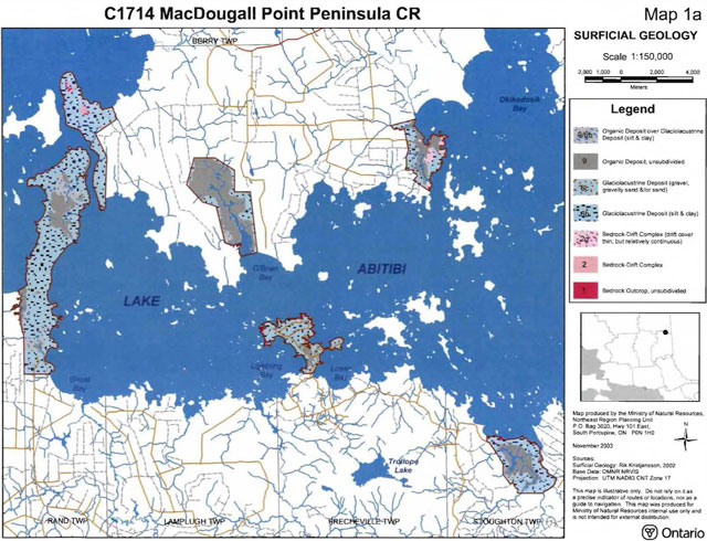
Enlarge C1714 MacDougal Point Peninsula Conservation Reserve map 1a
C1714 MacDougal Point Peninsula CR - Teddy Bear Marsh
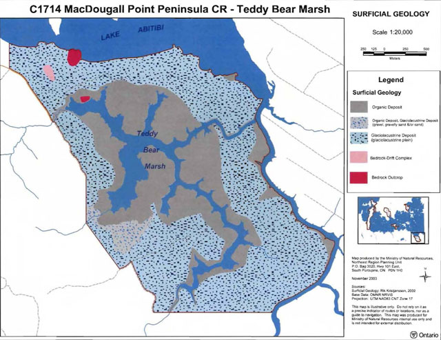
Enlarge MacDougal Point Peninsula Conservation Reserve Teddy Bear Marsh surficial geology map
C1714 MacDougal Point Peninsula CR Lightning Point
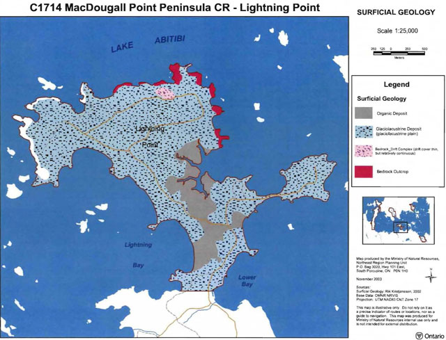
Enlarge C1714 MacDougal Point Peninsula Conservation Reserve Lightning Point map
C1714 MacDougal Point Peninsula CR - MacDougal Point
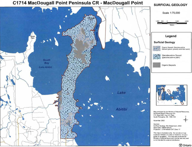
Enlarge MacDougal Point Peninsula Conservation Reserve MacDougal Point map
C1714 MacDougal Point Peninsula CR The Narrows
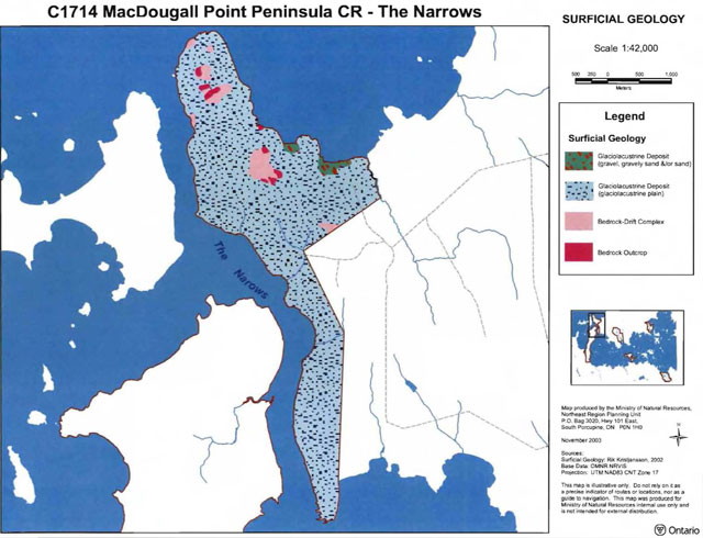
Enlarge MacDougal Point Peninsula Conservation Reserve the Narrows map
C1714 MacDougal Point Peninsula CR Swampy Creek
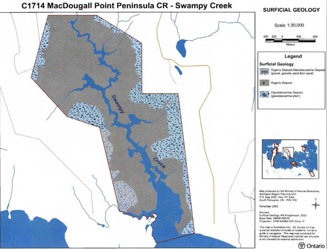
Enlarge MacDougal Point Peninsula Swampy Creek map
C1714 MacDougal Point Peninsula CR Okikodosik Narrows
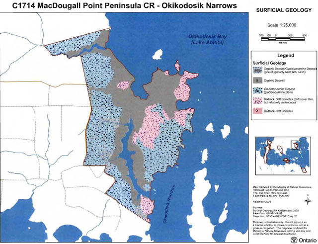
Enlarge MacDougal Point Peninsula Okikodosik Narrows map
C1714 MacDougal Point Peninsula CR Map 1b
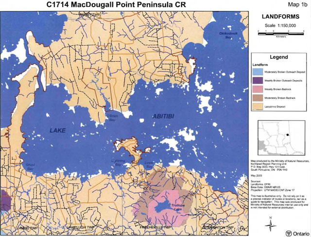
Enlarge MacDougal Point Peninsula Conservation Reserve map 1b
C1714 MacDougal Point Peninsula CR Map 2a
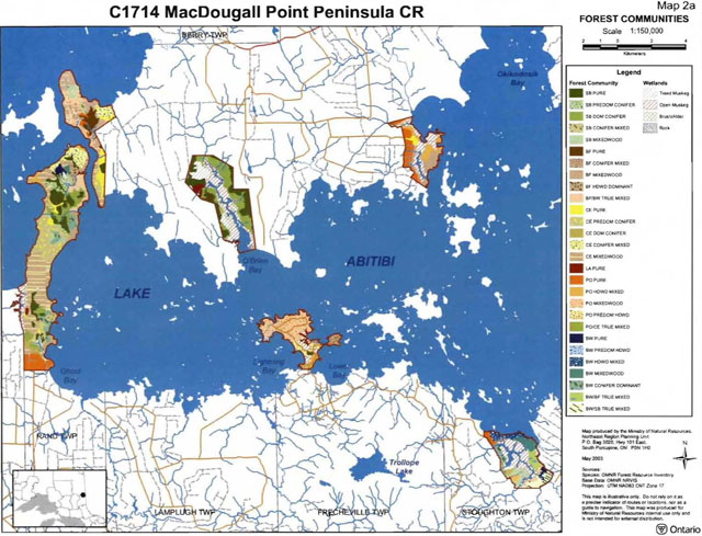
Enlarge MacDougal Point Peninsula Conservation Reserve map 2a
C1714 MacDougal Point Peninsula CR Map 2b

Enlarge MacDougal Point Peninsula Conservation Reserve map 2b
C1714 MacDougal Point Peninsula CR Map 2c
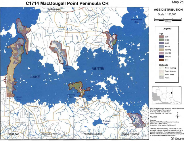
Enlarge MacDougal Point Peninsula Conservation Reserve map 2c
C1714 MacDougal Point Peninsula CR Map 2d

Enlarge MacDougal Point Peninsula Conservation Reserve map 2d
C1714 MacDougal Point Peninsula CR Map 3a
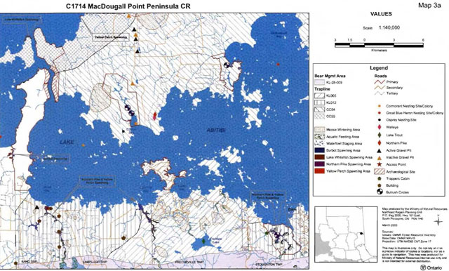
Enlarge MacDougal Point Peninsula Conservation Reserve map 3a
C1714 MacDougal Point Peninsula CR Teddy Bear Marsh map 3b
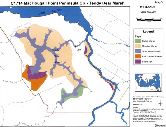
Enlarge MacDougal Point Peninsula Conservation Reserve Teddy Bear Marsh map 3b
C1714 MacDougal Point Peninsula CR Lightning Point map 3b
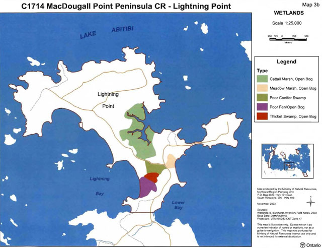
Enlarge MacDougal Point Peninsula Conservation Reserve Lightning Point map 3b
C1714 MacDougal Point Peninsula CR MacDougal Point map 3b
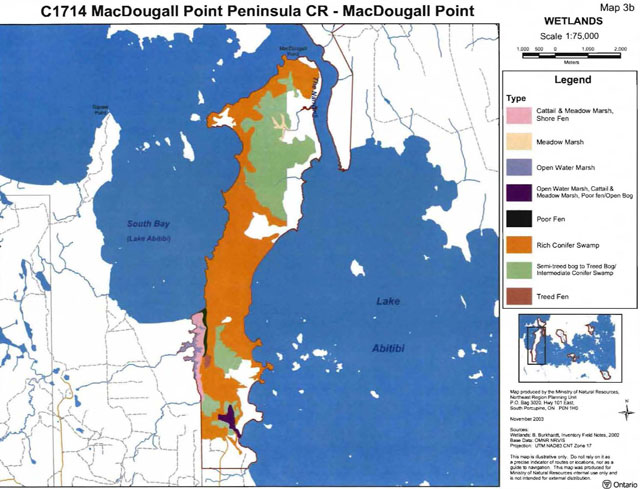
Enlarge MacDougal Point Peninsula Conservation Reserve MacDougal Point map 3b
C1714 MacDougal Point Peninsula CR MacDougal Point map 3b wetlands
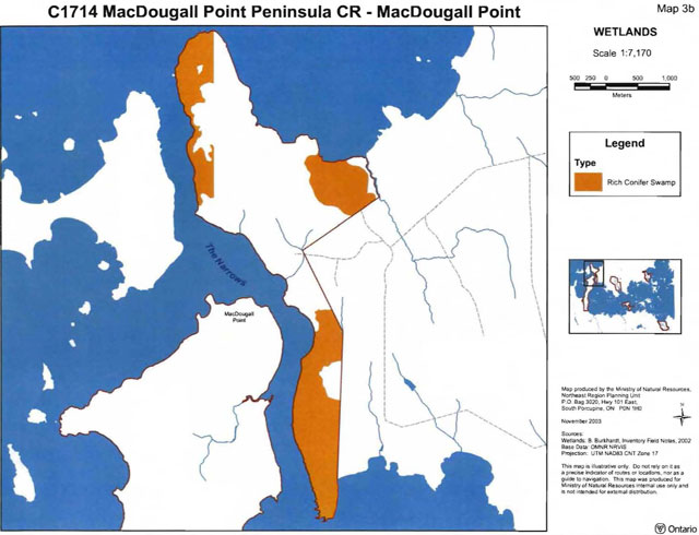
Enlarge MacDougal Point Peninsula Conservation Reserve MacDougal Point wetlands map 3b
C1714 MacDougal Point Peninsula CR Swampy Creek map 3b
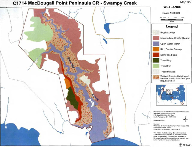
Enlarge MacDougal Point Peninsula Conservation Reserve Swampy Creek wetlands map 3b
C1714 MacDougal Point Peninsula CR Okikodosik Narrows map 3b
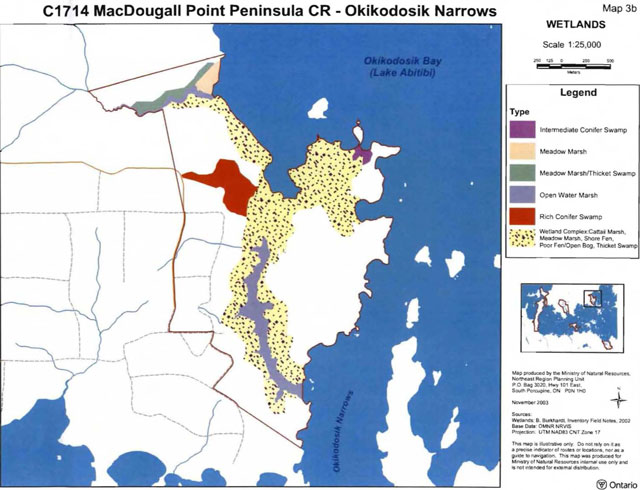
Enlarge MacDougal Point Peninsula Conservation Reserve Okikodosik Narrows wetlands map 3b
C1714 MacDougal Point Peninsula CR Teddy Bear Marsh map 4
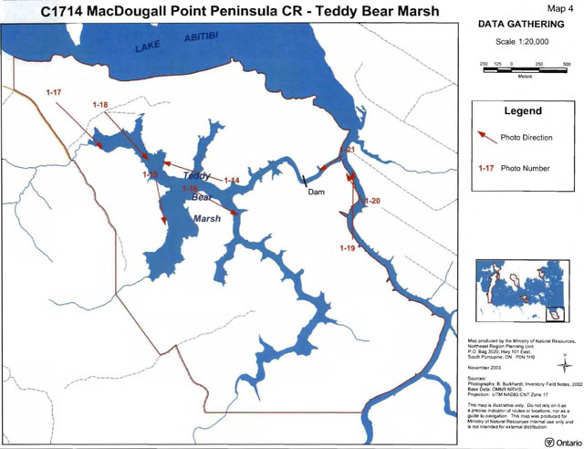
Enlarge MacDougal Point Peninsula Conservation Reserve Teddy Bear Marsh data gathering map 4
C1714 MacDougal Point Peninsula CR Lightning Point map 4
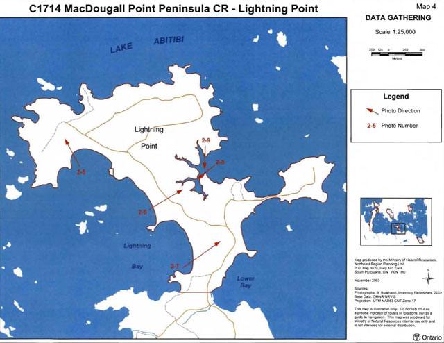
Enlarge MacDougal Point Peninsula Conservation Reserve Lightning Point data gathering map 4
C1714 MacDougal Point Peninsula CR MacDougal Point map 4
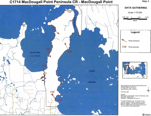
Enlarge MacDougal Point Peninsula Conservation Reserve MacDougal Point data gathering map 4
C1714 MacDougal Point Peninsula CR the Narrows map 4
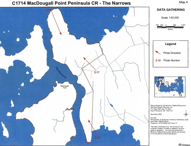
Enlarge MacDougal Point Peninsula Conservation Reserve the Narrows data gathering map 4
C1714 MacDougal Point Peninsula CR Swampy Creek map 4
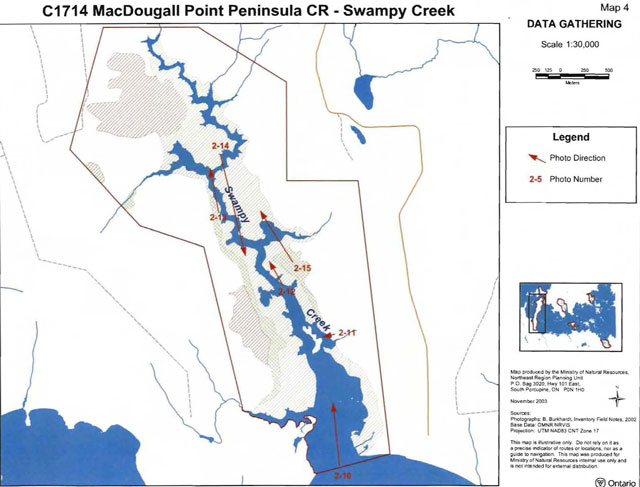
Enlarge MacDougal Point Peninsula Conservation Reserve Swampy Creek data gathering map 4
C1714 MacDougal Point Peninsula CR Okikodosik Narrows map 4
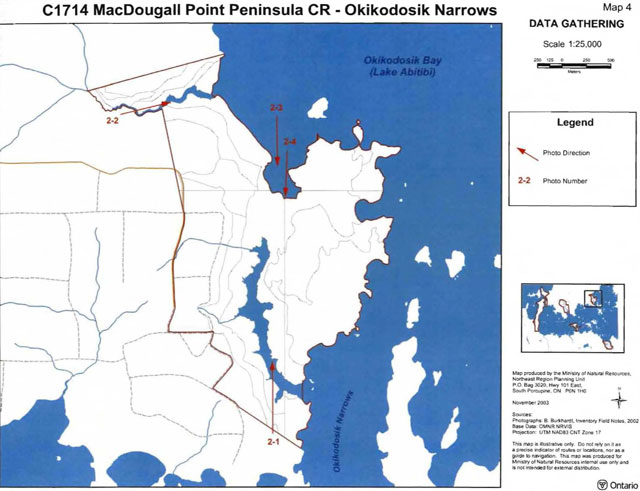
Enlarge MacDougal Point Peninsula Conservation Reserve Okikodosik Narrows data gathering map 4
C1714 MacDougal Point Peninsula CR MacDougal Point map 5
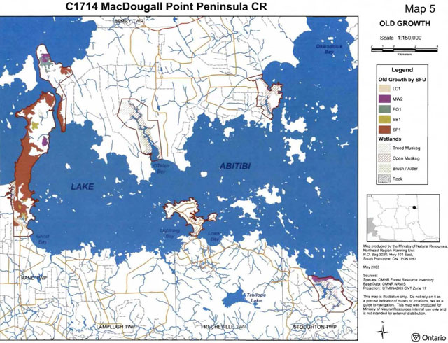
Enlarge MacDougal Point Peninsula Conservation Reserve old growth map 5
C1714 MacDougal Point Peninsula CR Geology and forest communities guideline only map
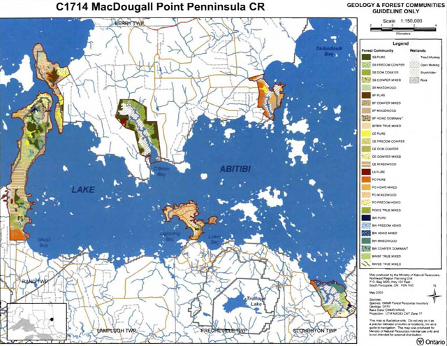
Enlarge MacDougal Point Peninsula Conservation Reserve geology and forest communities guideline map
C1714 MacDougal Point Peninsula CR History map
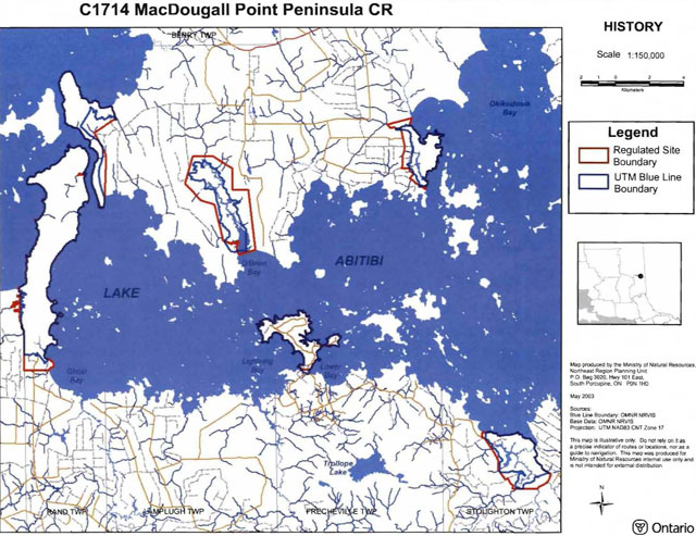
Enlarge MacDougal Point Peninsula Conservation Reserve history map
Appendix 9: Regulation maps
Plan of C1714 MacDougal Point Peninsula Conservation Reserve map Sheet 1 of 6
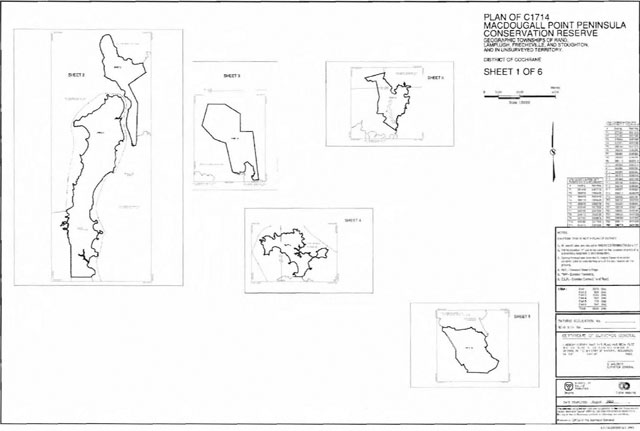
Plan of C1714 MacDougal Point Peninsula Conservation Reserve map Sheet 2 of 6
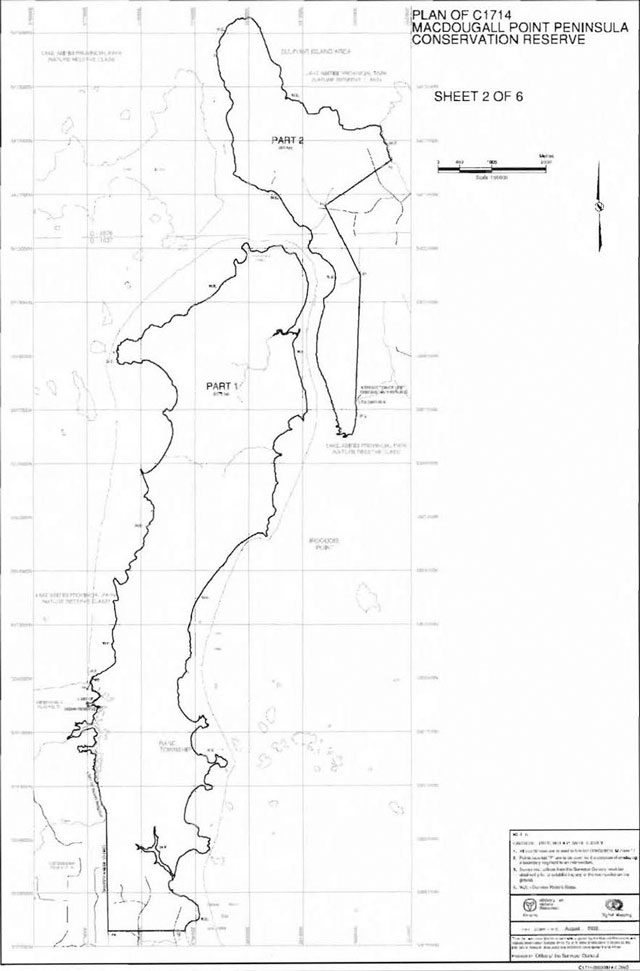
Plan of C1714 MacDougal Point Peninsula Conservation Reserve map Sheet 3 of 6
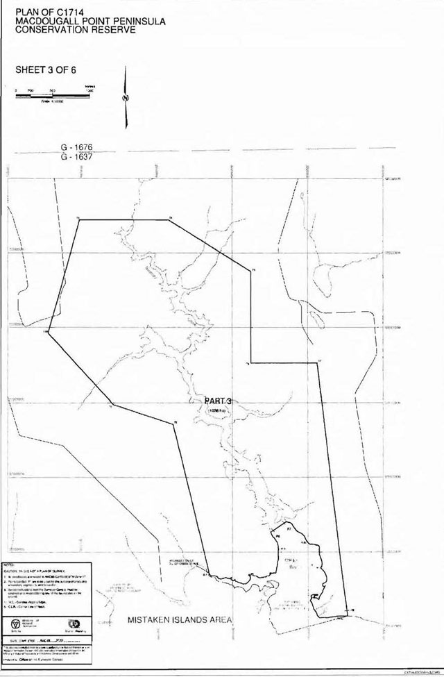
Plan of C1714 MacDougal Point Peninsula Conservation Reserve map Sheet 4 of 6
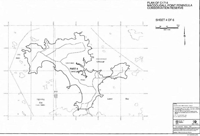
Plan of C1714 MacDougal Point Peninsula Conservation Reserve map Sheet 5 of 6
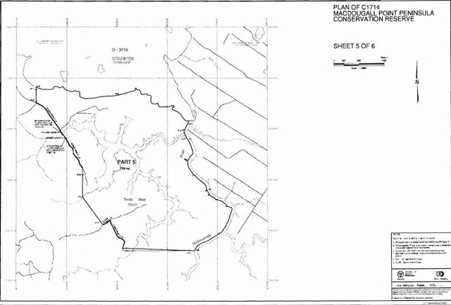
Plan of C1714 MacDougal Point Peninsula Conservation Reserve map Sheet 6 of 6
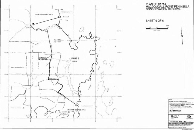
Appendix 10: Earth science planning summary
Earth science inventory checklist
Part one: Summary
- Name: MacDougal Point Peninsula
- OLL ID: C1714
- Lot: Concession
- Ownership: Crown
- Aerial photographs: See Detailed References, over
- MNR region: NER
- Park zone: NEZ
Earth science features
Poorly exposed Precambrian bedrock is overlain by relatively thick deposits of silt and clay, in the form of rhythmites and varves, interpreted to be of glaciolacustrine and lacustrine origin. Small raised beach bluffs cut into these deposits are a feature of the area and the CR.
Significance
The raised beaches and modern beach bluffs are valuable indicators of past processes in the Barlow-Ojibway basin, and are considered regionally significant. All other geological features are considered locally significant.
Sensitivity
Due to the fine-grained nature of the substrate, the delicate forms of the features and the high water table, all features except the exposed bedrock areas are considered to be highly susceptible to erosion and/or alteration should the vegetation cover be disturbed.
Recommendations
None
Major references
Vagners and Courtney 2000; see Detailed References
Date compiled
25 Aug. 2003
Compiler
PSG Kor
Part two: Detailed information
Protection history and setting
C1714 was identified for its life science values through the Ontario’s Living Legacy (OLL) Land Use Strategy (1999).
MacDougal Point Peninsula CR constitutes six (6) portions of the mainland around the central basin of Lake Abitibi. Three of these portions are primarily bedrockcontrolled ridges with extensive cover of postglacial and modern sediments, while the remaining three are centred on the lower reaches of minor rivers and embayments along the shore. These consist of a fine-grained, lake deposited sedimentary cover with thick accumulations of wetland (bog and marsh) vegetation.
Detailed earth science features
Bedrock Geology: Bedrock is poorly exposed in flat shoreline outcrops arid on top of ridges and knolls where these have not been covered by lake sediments. It consists primarily of igneous intrusive rocks and metavolcanic rocks. These lie in the Abitibi Subprovince, a subdivision of the Superior Province, Canadian Precambrian Shield. Only in the two western portions of C1714 does the bedrock topography influence the character of the CR.
Outcrop along the shorelines is not easily identifiable on airphotos due to its small size, low albido and most significantly, forest cover. Most of the outcrop locations indicated on the airphoto interpretation are based on information gathered from Vagners and Courtney (2000) and Jensen (1982), reports which are based on detailed field investigations. Outcrops may occur in mappable quantities (Unit 1) or as discrete locations (“ X” on airphotos).
Surficial Geology: Lake Abitibi is situated in a large plain of fine-grained sediments interpreted to represent glaciolacustrine and lacustrine deposition in the Abitibi basin from early postglacial time to the present. The basin formed part of the Barlow-Ojibway and Ojibway stages of glacial lakes following glacial retreat from the area some 10 000 years ago. Sedimentation into the basin continues to this day, evidenced by the muddy appearance of the lake waters. The sediments in the basin consist primarily of silt and clay, notably as rhythmites and/or varves. These are the most prevalent surficial sediments in all six portions of C1714, forming a thin veneer over bedrock topography (Unit 2bcd) and thicker deposits in intervening lowland areas (Unit 6b). The sediments are wellexposed in numerous bluffs along the shorelines of all portions of the CR. Although extensive slumping occurs in these bluffs, the rhythmites/varves and other sedimentary relationships and associations are commonly visible in section.
Boulder lags are noted in several shoreline localities at the base of unconsolidated bluffs. These may represent the coarse portion of tills overlying bedrock surfaces that have been washed by lacustrine shoreline processes. The tills may represent a thin discontinuous veneer over bedrock, largely hidden by a thick deposit of glaciolacustrine and lacustrine sediments.
Raised beaches, in the form of low bluffs or scarps cut into the glaciolacustrine and lacustrine cover, occur infrequently in the region of Lake Abitibi. These are difficult to identify on airphotos due to their poor definition (small size) and the density of the forest cover. Many of the raised beaches noted by Vagners and Courtney (2000) could not be confirmed through the airphoto interpretation. Those that were located are marked by the standard bluff symbol (line plus hash marks) on the airphoto interpretation. The raised beaches are not elevated very high above the present level of Lake Abitibi, being on the order of 2 to 10 metres higher. This suggests that the bluffs are likely relatively modern in age, and do not reflect early postglacial levels in the Abitibi basin. They may also represent the amount of postglacial isostatic rebound of the basin over the last few thousand years, after the establishment of the modern level of Lake Abitibi.
Modern sandy beaches are not common, but are a feature of some of the embayments of C1714. These pocket beaches appear to be associated with small sand flats which occur in topographic hollows in the fine-grained lacustrine sediment cover, and may therefore represent late depositional material accumulated as water levels in Lake Abitibi dropped to their present levels.
Wetland vegetation (probably primarily bogs and marshes), with some peat development, occur along shorelines, water courses, and in large and small depressions throughout the region, and are common features of C1714 (Unit 9). Where the cover of wetland vegetation appears to be relatively shallow (less than 1 m), the proximity of the substrate, interpreted to be glaciolacustrine/lacustrine in origin, is indicated (Unit 9/6b).
Some of the wetland vegetation areas along river courses may be considered modern alluvial deposits, but differentiation is not made on the airphotos. In particular, the portion of C1714 at Iroquois Point incorporates a riverine environment in which old levees and meander scars are features of the large wetland complexes adjacent to the river.
References
Jensen, L.S. 1982. Precambrian geology of the Lightning River area, Cochrane District; Ontario Geological Survey, Preliminary Map P.2433, scale 1:63 360. Vagners and Courtney 2000. Ontario geological Survey, Map
Footnotes
- footnote[1] Back to paragraph Mixedwoods are defined as follows: hardwood mixedwoods are stands dominated by hardwoods with less than 30% cover of conifer in the main canopy; similarly conifer mixedwoods contain less than 30% hardwoods in the canopy. Mixedwoods contain approximately equal percentages of conifer and hardwood trees and true mixedwoods contain a 50:50 split between conifers and hardwoods (modified after Taylor et al. 2000).
- footnote[2] Back to paragraph Conifer stands are defined as follows: pure conifer stands contain 100% of a conifer trees in the canopy; dominant conifer stands contain less than 10% cover of hardwoods in the main canopy and predominant conifer stands contain less than 20% cover of hardwoods in the main canopy. Similarly hardwood stands may contain no conifer in canopy (pure hardwood), less than 10% conifer (dominant hardwood) or less than 20% conifer cover (predominant hardwood) (modified after Taylor et al. 2000).
- footnote[3] Back to paragraph Wetlands were classified after Arnup et al.. 1999 and Harris et al.. 1996.
- footnote[4] Back to paragraph Rating based on the amount of area currently under some form of known disturbance. High is >20% of the area, medium 10 to 20 %. low <10% and pristine <1%.
- footnote[5] Back to paragraph Diversity rating, developed by John Thompson & Jake Noordhof (2003), is based on the size of the conservation reserve versus the number of landform:vegetation (SFU/HU) combinations. For CR’s <500 ha, high diversity is >25 L:V combinations, medium for >15 L:V, and low for <15 L:V. For areas 500-2000 ha, high is >30, medium >20 and low <20. For areas >2000 ha, high >35, medium >25 and low <25 L:V combinations.
- footnote[6] Back to paragraph Evenness of the site defined as strongly skewed (top 3 communities capture >=60% of the site in area), moderately skewed (30-59%) or slightly skewed to even (<30%).
- footnote[7] Back to paragraph Coordination could include a variety of expertise from the following: Field Services Division. Ontario Parks, Aviation and Forest Fire Management Branch, Forest Health and Silvicultural and Forest Management Planning Sections, Northeast Science and Information etc. Additional expertise within and outside the MNR could be sought as required.