McGarry Township Forest Conservation Reserve Management Statement
This document provides policy direction for the protection, development and management of the McGarry Township Forest Conservation Reserve and its resources.
Statement of Conservation Interest (C1705)
December 2002
Kirkland Lake District
Ministry of Natural Resources
Approval statement
I am pleased to approve this Statement of Conservation Interest (SCI) for the McGarry Township Forest Conservation Reserve.
Direction for establishing, planning and managing conservation reserves is defined under the Public Lands Act and current policy. "Ontario’s network of natural heritage areas has been established to protect and conserve areas representative of the diversity of the natural regions of the province, including species, habitats, features, and ecological systems which comprise that natural diversity." (Policy 3.03.05, MNR 1997).
This SCI will provide guidance for the management of the McGarry Township Forest Conservation Reserve and the basis for the ongoing monitoring of activities. More detailed direction at this time is not anticipated. Should significant facility development be considered or complex issues arise requiring additional studies, more defined management direction, or special protection measures, a more detailed Conservation Reserve Management Plan will be prepared with full public consultation.
The public was consulted on this site prior to its regulation during the planning for Ontario’s Living Legacy (MNR, 1999). Furthermore, the public was notified during a 30 day period in September, 2002 concerning a draft of this SCI. Comments from the notification period have been considered in the development of this document.
The McGarry Township Forest Conservation Reserve will be managed under the jurisdiction of the Kirkland Lake/Claybelt Area Supervisor of the Ministry of Natural Resources, Kirkland Lake District.
Plan Author:
Iisa Schoenijahn
Ontario’s Living Legacy Resource Manager
Kirkland Lake District
Approved and signed by:
Craig Greenwood
District Manager
Date: March 25, 2003
Approved and signed by:
Rob Galloway
Regional Director
Date: May 30, 2003
1.0 Introduction
Ontario’s network of natural heritage areas has been established to protect and conserve areas representative of the diversity of the natural regions of the province, including species, habitats, features and ecological systems which comprise that natural diversity. Protected natural heritage areas are a key component in sustainable management of natural resources. They ensure that representative sites within the larger sustainably managed landscape are permanently retained in their natural state.
Natural heritage areas are considered to be sensitive, requiring protection from incompatible activities if their values are to endure over time. The Ministry of Natural Resources has established conservation reserves as a new tool to offer protection for these areas on public lands, while permitting many traditional public uses to continue. Such uses include the traditional activities of Aboriginal Peoples.
Ontario’s Living Legacy Land Use Strategy (OLL LUS)(MNR, 1999) sets the direction for the administration and management of parks and protected areas on Crown lands within three planning regions including; the Boreal West, Boreal East and Great Lakes - St. Lawrence areas. This strategy’s natural heritage objectives include protection of natural and cultural heritage values and the provision of opportunities for outdoor recreation, heritage appreciation and tourism.
Protected areas designated within the OLL LUS have been selected based on their representation of the spectrum of the province’s ecosystems and natural features including both biological and geological features, while minimizing impacts on other land uses. Representation was described using landform and vegetation combinations based on Hill’s (1959) site district concept.
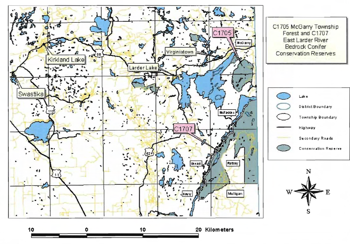
The McGarry Township Forest Conservation Reserve is a 1,434 ha parcel of Crown land that is situated southeast of Virginiatown. It is found within McGarry and McFadden Townships. These townships are located in the Kirkland Lake District within the MNR's Northeast Region. The McGarry Township Forest Conservation Reserve will be managed under a Statement of Conservation Interest (SCI).
SCI documents are the minimum level of management direction established for any conservation reserve and generally are brief management plans. This SCI will govern the lands and waters within the regulated boundary of the McGarry Township Forest Conservation Reserve. However, to ensure MNR protection objectives are being fully met within this conservation reserve, management of the surrounding landscape and related activities should consider the site’s objectives and heritage values. In addition, it is the intent of the SCI to create public awareness that will promote responsible stewardship of protected areas and surrounding lands. With management partners such as Ontario Parks, industry and local governments. MNR District staff will be able to pursue and advance sound environmental, economic and social strategies and policies related to the protection of conservation reserves and provincial parks.
The purpose of this SCI is to identify and describe the values of the McGarry Township Forest Conservation Reserve and outline the Ministry’s management intent for the conservation reserve. The management direction will protect the site’s natural heritage values and demonstrate its compatibility within the larger sustainable landscape. This direction will comply with land use intent as stated by the OLL Land Use Strategy (MNR, 1999).
2.0 Goals and objectives
2.1 Goal of Statement of Conservation Interest
The goal of this SCI is to describe and protect natural heritage values on public lands while permitting compatible land use strategies.
2.2 Objectives of SCI
2.2.1 Short term objectives
The short-term objectives are to identify the State of Resource in terms of natural heritage values and current land use activities for the McGarry Township Forest Conservation Reserve. A priority will be placed on the protection of the site’s natural values via specific guidelines, strategies and prescriptions detailed in this plan. Finally, legislated planning requirements will be met (e.g. SCI development within three years of regulation).
2.2.2 Long term objectives
The long-term objectives are to establish representative targets (e.g. future forest conditions) and validate the site as a potential scientific benchmark. To ensure protection of natural and cultural heritage features and values, this SCI will establish an evaluation process to address future new uses and commercial activities associated with them (e.g. Test of Compatibility Procedural Guideline B in Conservation Reserve Policy PL 3.03.05). Finally, this SCI will identify research/client services and marketing strategies.
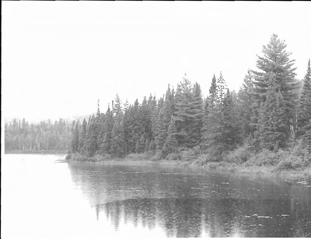
Figure 1. Boundary Lakes, located at the south-east corner of the site.
3.0 Management planning
3.1 Planning area
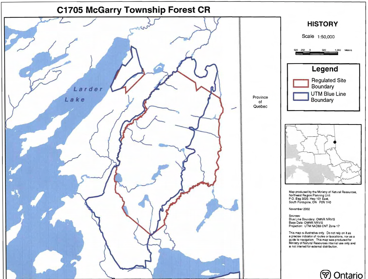
The planning area for this site will consist of the area within the regulated boundary for the McGarry Township Forest Conservation Reserve (Locator Map, Appendix #7). The SCI will recognize the protection of values within the planning area; however, to fully protect values within the conservation reserve, the lands beyond the regulated boundary may require additional consideration within larger land use or resource management plans may be required. Nevertheless, any strategies noted within this SCI related to the site’s boundary or beyond will need to be presented for consideration within a larger planning context.
3.2 Management planning context
The McGarry Township Forest Conservation Reserve was first designated as a candidate conservation reserve by MNR in the OLL Proposed Land Use Strategy (MNR March, 1999) and ultimately as a conservation reserve in the final OLL Land Use Strategy (MNR, 1999). The site was regulated with the filing of Ontario Regulation 148/02 made under the Public Lands Act on May 8, 2002. Management and planning direction for this site will follow the OLL LUS (MNR, 1999) and this management statement. The area encompassed by this site has also been removed from the Timiskaming Forest Alliance Inc. Sustainable Forest License (SFL) landbase.
By regulation, this conservation reserve cannot be used for commercial forest harvest, mining or hydroelectric power development. Existing permitted uses within this reserve may continue, such as fishing, hunting and trapping. This SCI document and future management of the site will continue to try to resolve conflicts regarding incompatibility between uses and to ensure that identified values are adequately protected.
This SCI will only address known issues or current proposals with respect to permitted uses or potential economic opportunities brought forward to the District Manager during this planning stage. However, in terms of approving future permitted uses and/or development(s), there are established mechanisms in place to address such proposals. Any future proposals will be reviewed using the Procedural Guideline B - Land Uses - Test of Compatibility Public Lands Act Policy PL 3.03.05 (MNR, 1997) or other standard MNR environmental screening processes.
Consideration for proposals pertaining to cultural resources may be screened through Conserving a Future for our Past: Archaeology, Land Use Planning & Development in Ontario, Section 3 (MCzCR, 1997), or in processes such as that used by MNR to establish Area of Concern (AOC) descriptions and prescriptions for cultural heritage resources within forest management plans (FMPs).
These planning tools will help refine the review process once the proposal satisfies the direction and intent of the Public Lands Act, associated policies and this planning document.
3.3 Planning process
Once a conservation reserve is passed into regulation, it must be determined what level of management planning is required to fulfill the protection targets. There are two possible planning documents. A Statement of Conservation Interest (SCI) is the minimal requirement for providing planning direction. A Resource Management Plan (RMP) deals with more complex issues where several conflicting demands are placed on the resources. The guidelines for the preparation of these documents are outlined in Procedural Guideline A-Resource Management Planning (Conservation Reserves Procedure PL 3.03.05 Public Lands Act). The appropriate plan must be completed within three years of the regulation date.
For current planning purposes, the McGarry Township Forest Conservation Reserve will be managed under the auspices of a Statement of Conservation Interest. Interested parties from both the private and public sector were consulted during the OLL planning process from candidate conservation reserve to regulation. A 30-day public review of a draft of this SCI document occurred during late November and December 2002. The intent of this SCI is to fulfill the commitments made within the OLL LUS.
The revised SCI was reviewed by the Kirkland Lake District Manager (DM). Upon approval by the DM the SCI will be presented to the Regional Director (RD) for final approval.
Following RD approval, interested public, user groups and industry will be notified that the Statement of Conservation Interest for the McGarry Township Forest Conservation Reserve was approved.
Public consultation will be solicited as part of any future reviews of land use proposals that would require new decisions to be made. In addition, any future proposal and/or any new, significant management direction considered will be published on the Environmental Bill of Rights Registry (EBR).
The SCI is a planning document that will provide background information, identify values to be protected and establish management guidelines for use in the administration of the reserve.
The implementation of the SCI will be the mandate of the MNR at the District level; however, associations with various partners may be sought to assist in the delivery. This SCI is a working document, and as a result, it may be necessary to make revisions to it from time to time.
4.0 Background information
4.1 Location and site description
4.1.1 Location
The following table describes the location and provides administrative details of the McGarry Township Forest Conservation Reserve:
Table 1: Location Data
| Name | McGarry Township Forest Conservation Reserve |
|---|---|
| Site Region - Site District (Hills) | 3E/6 |
| MNR Administrative Region/District Area | Northeast Region/Kirkland Lake District in the Kirkland Lake/Claybelt Area |
| Total Area | 1,434 ha |
| UTM co-ordinates | 080280 |
| Nearest Town/Municipality | Southeast of Virginiatown |
| Township(s) | McGarry, McFadden |
| OBM Numbers | 600053300, 600053200 |
| Topographical Map Name/Number | 32 D/4 |
| Wildlife Management Unit | 28 |
| Forest Management Unit | Timiskaming Forest |
4.1.2 Site description
4.1.2.1. Physical description
The McGarry Township Forest Conservation Reserve is located southeast of Virginiatown, a small community located on Highway 66 East of Kirkland Lake, Ontario. The conservation reserve is a 1,434 ha parcel located in McGarry and McFadden Townships (Locator Map, Appendix #7). The conservation reserve is made up of two distinct areas, a western part (Part 1) and a larger eastern part (Part 2) divided by a strip of land. The site has interesting topography dominated by two major bedrock ridges. A few rock faces with talus development were observed in the northwestern sections of both the western and eastern parts of the site. Ridges established well-developed plateaus, rock faces and slopes, which were directly accessible by trail (e.g. Part 1 cliff face) or indirectly by a series of three trails along the eastern boundary of Part 2.
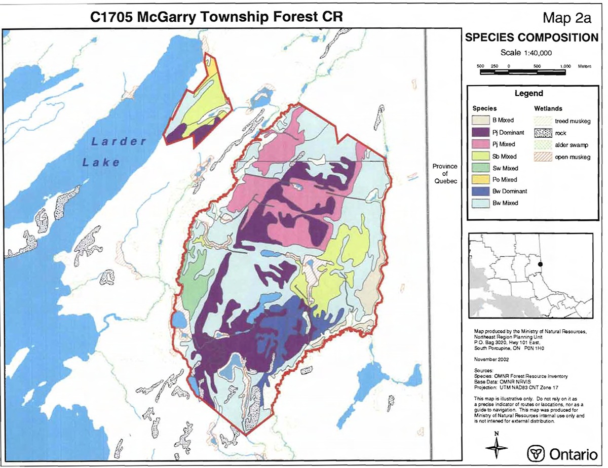
The tops and upper slopes of the ridges are dominated by White Birch, Jack Pine, and Maple mixed woods. Black Spruce and Tamarack forest stands dominate narrow valleys and low-lying areas.
The condition of both parts of the conservation reserve is excellent; however, the smaller western part (Part 1) is currently covered and surrounded by mining tenure resulting in its designation as a forest reserve rather than part of the conservation reserve at this time.
4.2 Administrative description
The legal boundaries of the McGarry Township Forest Conservation Reserve were filed on December 18, 2001 with the Office of the Surveyor General, Ministry of Natural Resources in Peterborough, Ontario. This site was passed into regulation on May 8, 2002 (O. Reg. 148/02).
4.3 History of site
Historically the site has been used for commercial fish and wildlife activities. The site contains portions of two Bear Management Areas, one baitfish area, and two traplines.
4.4 Inventories
The following table indicates the current status of natural heritage inventory that has occurred or is required in the near future.
Table 2. Inventory Data
| Survey level | Earth science | Life science | Cultural | Recreational | Other |
|---|---|---|---|---|---|
| Reconnaissance | August, 2001 | August, 2001 | Not required at this time | June/July/August 2001 | |
| Detailed | |||||
| Requirement |
5.0 State of the resource
Representation:
The majority of the McGarry Township Forest Conservation Reserve consists of moderately broken plains of granitic and low-base bedrock generally thinly covered with granitic and low-base sand and silty sand.
The predominant forest is mixed in character, consisting of an association of balsam fir, black spruce and white birch with scattered white spruce and trembling aspen, this appearing as a dominant type on middle slopes. On rocky shores, and also on ridges, there is some presence of eastern white and red pine, though these species have been mostly removed by logging several years ago. Black spruce and tamarack cover large areas of wet organic soil, and eastern white cedar accompanies black spruce in another common lowland association.
The site has interesting topography dominated by two major bedrock ridges. A few rock faces were observed with talus development observed in the northwestern section of both western and eastern parts of the site. The ridges established well-developed plateaus, rock faces and slopes, which were directly accessible by a trail or indirectly by a series of three trails along the eastern boundary of the eastern part. A major road runs from Highway 66 south, along the Ontario-Quebec border and the eastern boundary of Part 2 of the conservation reserve and links the three major trails.
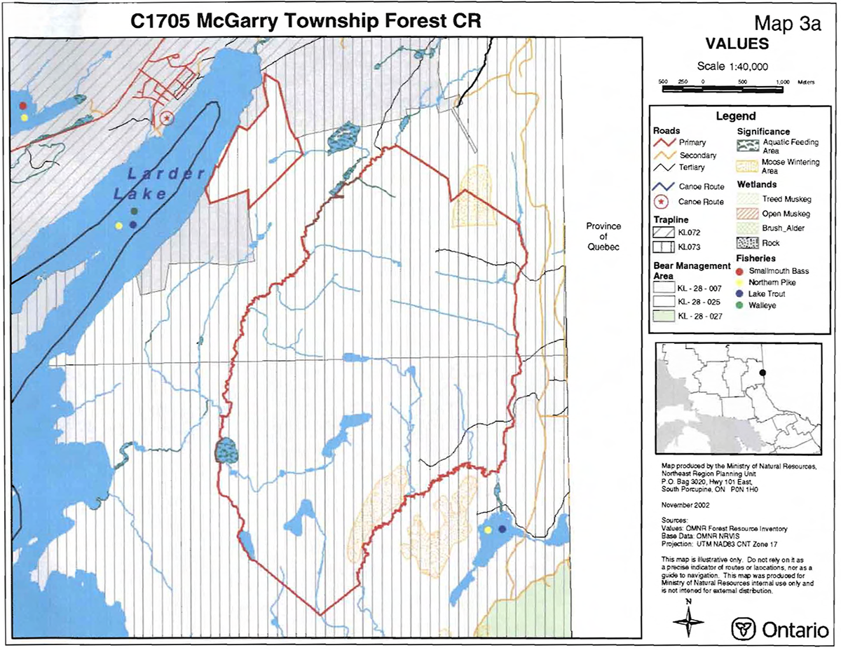
The wetlands within the site vary from bogs, peat lakes and wetlands, shoreline shrubs and alder swamps. A large alder swamp is located along the southeastern boundary and small peat wetlands are scattered throughout the site in Part 2. The small lakes present within the conservation reserve were not considered potential fishery resources; however, they contained an array of wetlands with boggy or grass-shrub heath defined shorelines. Northern pike and walleye are found in Boundary Lakes, Raven Lake and Larder Lake, which are in close proximity to the conservation reserve. Also, lake trout is found in Larder Lake and small mouth bass in Raven Lake (Map 3a). Moose aquatic feeding areas are located along the western boundary of Part 2 and a moose wintering area is situated along the eastern boundary of Part 2. Other moose wintering areas are found straddling the boundary or in close proximity.
Quality of representation:
The quality of the representation or the current characteristics of the natural features found within the conservation reserve are as important as the overall representative features that are being protected. A number of factors are considered in evaluating a site and they include the following criteria: diversity, condition, ecological factors, special features and current land use activities.
a) Diversity:
Diversity is a measure of the site’s life and earth science heterogeneity. The evaluation is based on the number and range (variety) of the natural landscape features and landforms for earth science values and the relative richness and evenness of the site’s life science components. Natural landscapes and known generalized vegetation communities will be the scale used for this Statement of Conservation Interest. Future aerial or ground reconnaissance surveys will enhance the MNR's knowledge of these features and possibly allow verification at a lower scale (e.g. species assemblages).
b) Condition:
Condition is the degree of past human and natural disturbances observed or recorded for the site.
c) Ecological factors:
Ecological factors refer to the current design of the conservation reserve as noted by its size, shape, buffering capacity to adjacent land use activities.
Aggregate extraction and road construction associated with forest operations would affect the morphological integrity of the features of this site. Due to the course grained character of the sediments, which generally underlie the conservation reserve, the potential for significant erosion and gully formation following the removal of alteration of the natural vegetation cover is low. However, erosion of the numerous steep slopes characteristic of this site may be a problem.
d) Special features:
The major features that are present within this conservation reserve include:
- Major bedrock ridges established with well-developed plateaus, rock faces and slopes.
- Moose aquatic feeding areas in the vicinity of Hanson Lake and moose habitat in the area of Hines Lake.
- Wetlands containing boggy or grass-shrub-heath defined shorelines.
e) Current land use activities
Only a small number of uses are known to be associated with this site. Activities include hunting, trapping, ATV use, snowmobiling, and hiking.
Summary:
The conservation reserve’s location within a forested landscape that does have access through three major trails into the reserve precludes the area to act as a remote or wilderness area. The trails do increase the potential for recreation activity in the conservation reserve. This particular site has a high activity attraction capability rating.
Forest Resource Inventory (FRI) data
- Dominant species, wetlands, and depleted areas
Values
- Moose aquatic feeding areas
- Moose wintering areas
- Larder Lake, Raven Lake and Boundary Lakes in close proximity to the site
- Heron nesting site located to the southwest of the site
- Osprey nesting site located to the southwest of the site
5.1 Social/economic interest in area
a) Linkage to local communities:
The McGarry Township Forest Conservation Reserve is a 1,434 ha parcel of crown land that is situated south of Highway 66 and southeast from Virginiatown, Ontario. The Conservation Reserve is located within McGarry and McFadden townships. The site is accessed by a major road running from Highway 66 south, along the Ontario-Quebec border and the eastern boundary of Part 2 of the Conservation Reserve.
Current uses are related to consumption of wildlife resources, such as in hunting and trapping. Ridges, cliff faces and current access routes would favor potential recreational activities such as rock climbing, landscape viewing and hiking.
b) Heritage estate contributions
The McGarry Township Forest Conservation Reserve contributes to the province’s parks and protected areas system through its regulation, representation and the long-term management of its natural heritage values. By allocating these lands to the parks and protected areas system through regulation, the province has ensured a certain level of permanence by distinguishing the site and its values from the larger general use or more extensively managed landscape. In addition, its natural features are, and will be available for present and future generations to enjoy and explore.
b) Aboriginal groups
The site is located within the Beaverhouse Aboriginal Community’s area of interest.
c) Mining interests:
The condition of both parts of the conservation reserve is excellent; however, the smaller western part (Part 1) is currently covered and surrounded by mining tenure resulting in its designation as a forest reserve rather than part of the conservation reserve at this time.
d) Forest and fire management history:
There have been no recent forestry management practices within the boundary of the conservation reserve. The site also has no recent burned areas within its boundary.
5.2 Natural heritage stewardship
5.3 Fish and wildlife
The small sized lakes present, within the conservation reserve, are not considered potential fishery resources; however, they do contain a collection of wetlands with boggy or grass-shrub-heath defined shorelines. Moose aquatic feeding areas have been recorded for the area encompassing Hanson Lake and potential moose habitat has been identified in the area of Hines Lake. Fishing would be an activity off site, within the Northeast arm of Larder Lake. Larder Lake is a cold water fishery containing lake trout, walleye, northern pike, and whitefish. Fishing opportunities are also present within the surrounding area of the reserve include Boundary Lakes, a northern pike fishery, and Raven Lake, a lake trout and walleye fishery.
5.4 Cultural heritage stewardship
To date, a detailed assessment of cultural resources has not been carried out.
5.5 Land use/existing development
The regulated portion of the conservation reserve is situated entirely on Crown Land and is unencumbered by any land use permits, leases or mining claims. Mining and surface rights have been withdrawn from the reserve (MNDM G-Plan M-0282 December 12, 2001).
5.6 Commercial land use
Present commercial use activities include two bear management areas (KL-28-25, KL-28-70), two traplines (KL-72, KL-73), and one baitfish operation (Baitfish Block.
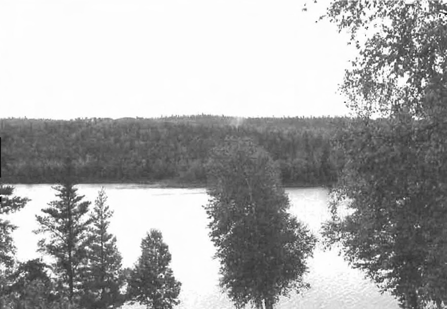
Figure 2. Raven Lake, a walleye and lake trout fishery, located in the southern vicinity of the site.
5.4 Cultural heritage stewardship
To date, a detailed assessment of cultural resources has not been carried out.
5.5 Land use/existing development
The regulated portion of the conservation reserve is situated entirely on Crown Land and is unencumbered by any land use permits, leases or mining claims. Mining and surface rights have been withdrawn from the reserve (MNDM G-Plan M-0282 December 12, 2001).
5.6 Commercial land use
Present commercial use activities include two bear management areas (KL-28-25, KL-28-70), two traplines (KL-72, KL-73), and one baitfish operation (Baitfish Block.
gathered on the area, such as the Earth/Life Sciences and Recreational inventory work.
6.0 Management guidelines
6.1 Management planning strategies
The land use intent outlined in the OLL LUS (MNR, 1999) provides context and direction to land use, resource management, and operational planning activities on Crown Land in the planning area and within the OLL site boundaries. Commitments identified in the OLL LUS and current legislation (Policy 3.03.05 PLA) forms the basis for land use within the McGarry Township Forest Conservation Reserve. Management strategies for these uses must consider the short and long-term objectives for the conservation reserve. For up to date information on permitted uses refer to the, Crown Land Use Atlas (MNR, 2002) (/page/crown-land-use-policy-atlas)
Proposed new uses and development will be reviewed on a case-by-case basis. A Test of Compatibility, (Procedural Guideline B-Land Uses (PL 3.30.05)) must be passed before proposals can be accepted. In all cases, ensuring that the natural values of the conservation reserve are not negatively affected by current and future activities will be the priority. Therefore any application for new specific uses will be carefully studied and reviewed.
6.2 "State of the Resource" management strategies
The development of this SCI and the long term management and protection of the McGarry Township Forest Conservation Reserve will be under the direction of the MNR's Kirkland Lake District, Kirkland Lake/Claybelt Area Supervisor. The following management strategies have been created to achieve the goal and objectives stated earlier in this management document.
Natural heritage stewardship
The management intent for the McGarry Township Forest Conservation Reserve is to allow for natural ecosystems, processes and features to operate undisturbed with minimal human interference while providing educational, research and recreational activities.
Forest fire protection will be carried out as on surrounding public lands, under the direction of the provincial fire strategy. All wildfire occurrences will be considered a high priority and will actively be suppressed. Prescribed burning will be conducted only under the direction of the provincial fire strategy and authorized for the conservation reserve under a separate vegetation management plan. Prescribed burning may be utilized if deemed necessary to emulate natural disturbances and renew forest communities, prepare seed beds for research and/or education purposes or to meet additional objectives determined within a separate vegetation management plan.
Defining compatible uses, enforcing regulations and monitoring and mitigating issues will protect all earth and life science features. Industrial activities such as commercial timber harvest and new hydro generation will not be permitted within the conservation reserve. Permits for fuel-wood will not be issued. New energy transmission, communication and transportation corridors or construction of facilities are not permitted within the boundaries of the conservation reserve. Such structures negatively impact the quality of the representative features that require protection. Alternatives should be reviewed via larger landscape planning processes. New roads for resource extraction will not be permitted. Other activities that do not pass a Test of Compatibility will be prohibited (MNR Policy 3.03.05, 1997).
The introduction of exotic and/or invasive species will not be permitted. Programs may be developed to control forest insects and diseases where they threaten significant heritage, aesthetic, or economic values. Where control is desirable, it will be directed as narrowly as possible to the specific insect or disease. Biological or non-intrusive solutions should be applied whenever possible.
The collection/removal of vegetation and parts thereof will not be permitted; however, subject to a Test of Compatibility, the Area Supervisor may authorize such activities for purposes of rehabilitating degraded sites within the reserve, collecting seeds for maintaining genetic stock and/or for inventory or research purposes.
MNR will provide leadership and direction for maintaining the integrity of this site as a heritage estate. To ensure MNR protection objectives are fully met within the conservation reserve, activities on the surrounding landscape must consider the site’s objectives and heritage values. Research, education and interpretation will be encouraged to provide a better understanding of the management and protection of the natural heritage values and will be fostered through local and regional natural heritage programs, initiatives and partnerships.
The conservation reserve will be managed by allowing natural ecosystems, processes, and features to function normally, with minimal human interference.
Fish and wildlife
Fish and wildlife resources will continue to be managed in accordance with specific policies and regulations defined by the Ontario Ministry of Natural Resources under the Fish and Wildlife Conservation Act and the Kirkland Lake District, Kirkland Lake/Claybelt Area Supervisor.
Fishing and hunting is expected to continue at a low level of intensity. A planned trail and viewing area development may enhance wildlife viewing activities. Any future trail development will require a test of compatibility.
Cultural heritage
When possible, the Ministry of Natural Resources will continue to work with the Ontario Ministry of Culture, Tourism and Recreation in identifying archaeological sites to be protected. To more fully manage and protect sites, the development of field surveys would be required. However, at this time additional field surveys within this conservation reserve are not recommended.
Development, research and education proposals may be considered in accordance with the Test of Compatibility and Conserving a Future for our Past: Archaeology, Land Use Planning & Development in Ontario, Section 3 (MCzCR, 1997).
Land use and development
The sale of lands within the conservation reserve is not permitted as per the OLL LUS (MNR, 1999). Existing authorized trails can continue to be used and maintained, unless there are significant demonstrated conflicts. New trails will only be allowed if a Test of Compatibility is passed. The cutting of trees for non-commercial purposes (e.g. fuelwood) is not permitted except as required for approved development activity (e.g. trail, viewing site, etc.).
New roads for resource extraction will not be permitted. Abandoned forest extraction roads will not be actively maintained. There are no other forms of tenure in the conservation reserve other than legal agreements with registered trappers, bear management area operators and baitfish licensees. No new trap cabins will be permitted.
Traditional uses within the conservation reserve will continue to be permitted; however, the goal will be to resolve conflicts regarding incompatibility between uses and to ensure that identified values are adequately protected.
Commercial use
All existing commercial bait fishing and commercial bear hunting (within BMAs) operations are permitted to continue. Commercial bear hunting operations is permitted and the transfer of existing licenses is allowed.
Existing commercial fur harvesting operations are permitted to continue. New operations may be considered subject to a Test of Compatibility.
Aboriginal interests
The McGarry Township Forest Conservation Reserve is within the Beaverhouse First Nation’s area of interest. Aboriginal and treaty rights will continue to be respected throughout the management of this conservation reserve. Any future proposal(s) and or decision(s) that have potential impact(s) on individual aboriginal values and or communities will involve additional consultation with the affected aboriginal groups.
Tourism/recreation
The earth and life science features and their protection, shall be the overall theme for tourism. Small-scale infrastructures for enhancing tourism and recreation (i.e., warm-up shelter) may be considered, providing they pass a Test of Compatibility and other MNR requirements.
Most recreational activities that have traditionally been enjoyed in the area can continue provided they pose little or no threat to the natural ecosystems and features protected by the conservation reserve. These permitted activities include walking, hiking, wildlife viewing, fishing, hunting, snow shoeing, and crosscountry skiing.
Snowmobiles and all-terrain vehicles (ATVs) are permitted on existing trails and forest access roads within the Conservation Reserve. Under the OLL LUS (MNR, 1999), all mechanized travel is restricted to existing trails. Off trail vehicle use is permitted for the retrieval of game only. The use of existing trails, within the McGarry Township Forest Conservation Reserve, does not degrade the values of this site.
Existing trails for hiking, snowmobiling, ATV use, cycling, horseback riding and cross-country skiing can continue. To ensure the quality of the representation is maintained, all trails and old forest access roads within the site should be identified via new technologies (i.e. GPS) to ensure a record of these features exists. New trails can be considered through a Test of Compatibility.
Finally, conflict resolution between recreational uses will be a priority. This will be achieved by adhering to the objectives of this SCI with input from relevant user groups. The level of safety and compatibility between activities will determine permitted uses (i.e. Test of Compatibility).
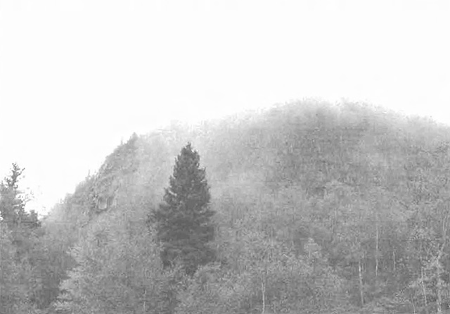
Figure 3. Cheminis Mountain, with its hiking trails and scenic views, enhances the recreational features of the conservation reserve.
Client services
Clients indicating their interest in the management, planning and future use of the conservation reserve will be put on a mailing list and notified of any future planning related to the site.
Present client services such as supplying maps, fact sheets and other information will also continue. Information may be delivered from different sources; however, MNR will be the lead agency for responding to inquiries
6.4 Promote Inventory, Monitoring and Assessment Reporting (IMAR), and research
Scientific research by qualified individuals, which contributes to the knowledge of natural and cultural history and to environmental and recreational management, will be encouraged.
Additional life science inventory or research is required at this time to refine values and features. Additional assessment and monitoring of the disturbed areas, including trail and old road locations, within the site should occur prior to any additional management direction being finalized in a vegetation management plan for the area.
Research related to the study of natural processes will be encouraged provided it does not harm the values of the reserve. The Kirkland Lake/Claybelt Area Supervisor or District Manager may approve the removal of any natural or cultural specimen by qualified researchers. All such materials removed remain the property of the Ministry of Natural Resources. All research programs will require the approval of the Ministry of Natural Resources and will be subject to Ministry policy and other legislation.
New research developments such as campsites, privies, trails or developed access points or activities will not be considered until a Test of Compatibility is conducted and the proposal is approved by the Kirkland Lake/Claybelt Area Supervisor or District Manager. The Test of Compatibility or environmental screening process could include a review of the demand for structures or activities and may require more detailed life or earth science or cultural information and possibly a more detailed resource management plan.
Approved research activities and facilities will be compatible with the site’s protection objective. Permanent plots or observation stations may be established to which researchers can return over time. Any site that is disturbed will be rehabilitated as closely as possible to its original state.
6.5 Implementation, and plan review strategies
McGarry Township Forest Conservation Reserve Statement of Conservation Interest will be reviewed on an ongoing basis and as required.
Implementation of the SCI and management of the reserve are the responsibility of the Kirkland Lake/Claybelt Area Supervisor. Partnerships may be pursued to address management needs.
If changes in management direction are needed at any time, the significance of the changes will be evaluated. Minor changes that do not alter the overall
Appendix #1
Public consultation summary
SCI public consultation summary (C1705)
| Date received | Client | Comment | Action taken | Date responded |
|---|---|---|---|---|
| 07-September-00 | #1 | Was concerned with future use of OLL sites and about access to lakes. | Explained that he can continue to hunt, fish and trap. Also explained that access to lakes would not be affected, as long as it was an existing road or trail. | 07-September-00 |
| 27-September-00 | #2 | Was concerned with the information provided, felt that the factsheet was incomplete and confusing. Client requested additional information. | Client was sent more information, the OLL Land Use Strategy, and to contact the OLL interns if they were in additional need of clarification. | 03-October-00 |
| 05-October-00 | #3 | Was concerned with the boundaries of this site. | Client was sent a letter stating that his comments were under review and that he would be notified if there were any changes to the boundaries. | 16-October-00 |
| 06-October-00 | #4 | Was not happy with consultation package or map sizes. Also was concerned with fishing and hunting in OLL sites and wanted information on roads and access to sites. | Explained that because of the variety of sizes of the sites, that it is not possible to have both scale and paper sizes the same for all sites. Also, fishing and hunting could continue as it had in the past, as well that existing roads would continue to be available for access including maintenance and upgrading. | 23-October-00 |
| 08-February-01 | #5 | Requested maps and some info regarding all OLL sites, as he was speaking on behalf of a snowmobile club. He was asking about trails and development of new trails for the purpose of snowmobiling. | He was sent, via mail, info on existing and new trails, as well as provided with the strategy and all 26 site maps. | 08-February-01 |
| 18-January-02 | #6 | Wanted to know if there were any changes from previous correspondence on OLL sites (Bear Management Areas). Was also interested in updated maps for comparison. | Advised client that there is a website regarding OLL. Forwarded copy of permitted uses for OLL sites. | 18-January-02 |
| 18-January-02 | #7 | Requested better maps showing boundaries of OLL sites. | Sent email with web address for OLL. | 18-January-02 |
| 27-January-02 | #8 | Client had questions regarding forest reserves within conservation reserves. Also had questions on mining activities in OLL sites. | Explained that no information specifically on forest reserves was in the report. Forwarded sections on natural heritage stewardships to help answer any questions. Also sent info on mining interest. | 28-January-02 |
| 03-September-02 | #9 | Client came into the office with concerns of permitted uses in the area of this site. | Client was reassured that existing uses were still permitted to continue, with the exception of timber practices. | 03-September-02 |
Appendix #2 - SCI Consultation Ad
Preparation of Statements of Conservation Interest
Kirkland Lake District
As part of the ongoing implementation of Ontario’s Living Legacy, the Kirkland Lake District Ministry of Natural Resources (MNR) is preparing Statements of Conservation Interest (SCI) for six conservation reserves. The ministry invites you to participate in the review of the draft statements of conservation interest for the Wapus Creek, Brace Creek Outwash Plain, Big Spring Lake Bedrock, Hilliardton Marsh, McGarry Township Forest, and East Larder River Bedrock Conifer Conservation Reserves.
The statements of conservation interest will clarify the values and uses within the individual conservation reserves and provide direction on how the area will be managed.
The six sites are located in the following townships:
| Conservation reserve | Area (ha) | Townships |
|---|---|---|
| Cl595 Wapus Creek | 2216 | Leonard, Leith, Ray, North Williams |
| Cl599 Brace Creek | 4705 | Ray, Leckie |
| Cl617 Big Spring Lake Bedrock | 973 | Barber, Cane |
| C1704 Hilliardton Marsh | 5787 | Ingram, Pense, Hilliard, Brethour, Harley, Casey |
| Cl705 McGarry Township Forest | 1634 | McGarry, McFadden |
| Cl707 East Larder River Bedrock Conifer | 7089 | McFadden, Rattray, Skead, Bayly, Mulligan |
The Ministry of Natural Resources (MNR) is collecting comments and information regarding the draft statements of conservation interest under the authority of the Environmental Assessment Act to assist in making decisions and determining future public consultation needs. Comments and opinions will be kept on file for use during the plan’s operating period and may be included in the study documentation, which is available for public review.
Under the Freedom of Information and Protection of Privacy Act (1987) personal information may be used by the Ministry of Natural Resources to seek public input on the other resource management surveys and projects. For further information on this Act, please contact Eleanor Moro at (705) 568-3244.
If you wish to become part of the local mailing list for these sites or if you have specific questions or concerns, please contact:
Shaun Walker
District Planner
Ministry of Natural Resources
Kirkland Lake District
P.O. Box 910, 10 Government Road East
Kirkland Lake, ON
P2N 3K4
Tel: (705) 568-3231
Fax: (705) 568-3200
Please respond by September 17, 2002
Renseignement en franrcais: (705) 568-3222
Appendix #3 - Recreational Inventory Check-Sheet
McGarry Township Forest Conservation Reserve C1705
Recreational Inventory Checklist
April 30, 2001
Erica Coulson and John E. Thompson
Recreation inventory checklist
| Name: | C1705 McGarry Township Forest Conservation Reserve |
|---|---|
| Map name: | Larder Lake |
| NTS Number: | 32D/4 |
| UTM reference: | :080280 |
| OBM Number: | 6000, 53300 |
| Latitude: | 48°06' |
| Longitude: | 79°33' |
| Area (ha): | 1,526.00 |
| Ownership: | Crown |
| MNR region: | Northeast |
| MNR district: | Kirkland Lake |
| Park zone: | Northeast |
| Township: | McGarry, McFadden |
| Recreation features | Recreation activities |
|---|---|
| 1. Q13-Ridge | 1. Q04-Landscape Viewing |
| 2. Q19-Cliffs/Rock Faces | 2. r03-Rock Climbing |
| 3. Q12-Plateau | 3. T08-Hiking |
| 4. E05-Mixed Coniferous/Deciduous | 4. T01-ATV |
| 5. E08-Wetland Vegetation | 5. H00-Hunting/Trapping |
| 6. M02-Lake, Small (0-40 ha) | 6. F00-Fishing |
| 7. T03-Land Routes | 7. |
| 8. | 8. |
| Recreation factors | Features | Rating: Very High - High - Moderate - Low - N/A |
|---|---|---|
| Most Scarce Feature | 5 | |
| Feature Scarcity | Moderate | |
| Most Unique Feature: | 1 | |
| Activity Attraction Capability: | High | |
| Scenic Attractiveness: | High | |
| Geographic Significance: | Moderate | |
| Feature Significance: | Moderate | |
| Most Sensitive Feature To Recreation Use: | 5 | |
| Feature Sensitivity To Recreation Use: | Moderate | |
| Most Sensitive Feature To Resource Development: | 5 | |
| Feature Sensitivity To Resource Development | Moderate | |
| Cultural/Historic and Archaelogical Features: | N/A |
Date compiled: 9/29/00
Compiler: Erica Coulson and J.E. Thompson
Source: Recreation Resource Inventory Standards and Proceedures Draft Report, Gov. of British Columnbia, Ministry of Forests Range, Recreation and Forest Practices Branch, March 1995.
Ontario Ministry of Natural Resources, Ontario Parks
300 Water Street, Peterborough, Ontario K9J BN1
Recreation Inventory Checklist
Name: C 1705 McGarry Township Forest Conservation Reserve
Comments:
Conservation Reserve C 1705 is located southeast of Virginiatown, Ontario a small community located on Highway 66 east of Kirkland Lake, Ontario. The Conservation Reserve is made up of two distinct areas. A western part (Part 1) and larger eastern part (Part 2) with both parts divided by a strip of land. The site has interesting topography dominated by two major bedrock ridges (Ql3). A few rock faces (Ql9) were observed with talus development observed in the northwestern sections of both the western and eastern parts of the site. Ridges established well-developed plateaus, rock faces and slopes, which were directly accessible by a trail (T03) (e.g. Part 1 cliff face) or indirectly by a series of three (3) trails (T03) along the eastern boundary of Part 2. A major road runs from Hwy 66 south, along the Ontario-Quebec border and the eastern boundary of Part 2 of the Conservation Reserve and links the three major trails. Ridges, cliff faces and current access routes would favor recreational activities such as; rock climbing (r03) landscape viewing (Q04), hiking (T08) and ATV (T01) use. The current access and small sizes of both parts of the site preclude the area to act as a remote or wilderness area.
The tops and upper slopes of the ridges were dominated by white birch, jack pine and maple mixed woods (E05). Black spruce and tamarack forest stands dominated narrow valleys and low-lying areas. The small size lakes (M02) present were not considered potential fishery resources; however, they contained an array of wetlands (E08) with boggy or grass-shrub-heath defined shorelines. Moose aquatics (W03) have been recorded for Hanson Lake. Present or potential recreational activities would be related to terrestrial rather than aquatic features. The Conservation Reserve has potential for hunting and trapping (H00). Fishing (F00) would be a recreational activity off site within the northeast arm of Larder Lake, a lake trout lake and to the southeast including Raven Lake and Larder River Provincial Park. An old fire tower is present in the northern section of Part 2 and is linked to the eastern access routes previously mentioned. Condition of both parts of C 1705 is excellent; however, the smaller western part (Part 1) is currently covered and surrounded by mining tenure resulting in the establishment of a forest reserve and not a regulated conservation reserve at this time.
Features sensitive to future recreation or resource development would include both the wetland areas and possibly the ridges and rock faces to rock climbing. Use of ATV's will have to be considered in any future planning initiative. The western part (Part 2) could be an excellent candidate as an IMAR site - so future recreational planning or development should consult life and earth science check-sheets and recognize the sensitivity of the natural values to any future recreational activity. In addition, future planning should work with the access that is currently present. In the near future, all current access and human disturbance (e.g. fire tower) should be mapped in the field using the latest satellite (e.g. GPS) and computer (e.g. GIS) technologies.
MNR Proposed Boundary Map
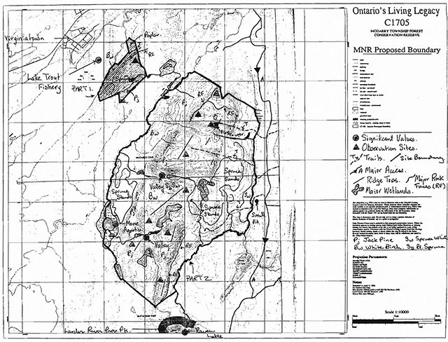
Enlarged MNR Proposed Boundary Map
Appendix #4 - Procedural Guideline B - Land Uses - Test of Compatibility
(PL Procedure 3.03.05)
The Conservation Reserve policy provides broad direction with regard to the permitted uses. The policy provides only an indication of the variety of uses that will be considered acceptable in Conservation Reserves. The only caution is that "any new uses, and commercial activities associated with them, will be considered on a case by case basis and, they must pass a test of compatibility to be acceptable."
What does a "test of compatibility" mean? An examination of this must start from the premise of why an area is set aside-specifically, its representative natural heritage values. Criteria are then identified to guide compatibility considerations. These criteria apply to the long-term acceptability of both existing uses and new uses.
-
Conformity to SCI/RMP: SCI describe values for which an area has been set aside and the range of appropriate uses that will be permitted in the area. SCI may also speak to the acceptability of other 'new' uses currently not occurring in the area.
The first 'test' is: "do proposed new land uses and/or commercial activities conform to the direction of the SCI/RMP for the conservation reserve? Would the new use(s) depart from the spirit of appropriate indicator land uses in the SCI/RMP?"
- Impact Assessment: If the proposed use(s) pass test 1 it is important to determine their impact on the area before they are approved. This should include the following:
- Impact on natural heritage values: "will the new use(s) impact any natural values in the area? If so how and to what degree? Is it tolerable?"
- Impact on cultural values: "will the new use(s) impact an historical or archaeological values in the area?"
- Impact on research activities: "will the new use(s) affect research activities in the area?"
- Impact on current uses: "will the new use(s) have any negative impact on the array of current uses?"
- Impact on area administration: "will the new use(s) increase administrative costs and/or complexity?" (For example, the cost of area monitoring, security and enforcement).
- Impact on accommodating the use outside the conservation reserve: "Could the use(s) be accommodated as well or better outside the conservation reserve?"
- Impact on socio-economics of the area: "will the new use(s) affect the community(ies) surrounding the area in a positive or negative way?" (For example, will the new use make an area less remote thereby affecting a local tourism industry that is dependent on the area’s remoteness for its appeal?"
- Impact on area accessibility: "does the new use(s) give someone exclusive rights to the area or a portion of the area to the exclusion of other existing uses?"
Appendix #5 - Procedural Guideline C - Research Activities in Conservation Reserves
Purpose
To encourage contributions to the goal of conservation reserves by:
- Providing direction for research activities associated with conservation reserves: and
- Establishing a process for the review and approval of proposals by researchers, which could have an impact on the values protected by the conservation reserve
Definition
Research means any investigation or study of the natural, cultural, social, economic, management or other features of characteristics of conservation reserves.
Guidelines
Research will be encouraged to provide a better understanding of the natural values protected by a conservation reserve and to advance their protection, planning and management. The Statement of Conservation Interest will define, for each conservation reserve, the key research issues, set out the parameters within which research may occur and identify research needs.
Applications and approvals
Researchers must apply in writing to the Area Supervisor for permission to conduct research. The request letter must contain a statement explaining why the proposed research should be undertaken in the particular conservation reserve in preference to another location.
Proposals will be reviewed and approved by the Area Supervisor, guided by the Statement of Conservation Interest prepared for each reserve (See Guideline A Resource Management Planning) and using Guideline B-Land Uses - Test of Compatibility. Permission must be granted in writing, including any conditions to be met in conducting the research, prior to the undertaking of any research project.
Terms and conditions
Permission to conduct research under this policy will be valid for a period of 12 consecutive months from date of issue. Permission to continue a research project for additional periods of 12 months or less may be granted upon submission of a written request and progress report. The Ministry may require the posting of collateral to assure that the terms and conditions of granting permission are to be met.
The Area Supervisor may suspend or revoke permission at any time for failure on the part of the researcher to meet:
- The intent or conditions of this policy.
- The requirements under the Public Lands Act, including all amendments, where applicable.
- The requirements under any other Act or Regulations or Ontario or Canada, including those governing the taking, handling, storing, confining, trapping, excavating and marketing any specimen, artifact, information or action (for example, scientific collector’s permit).
- The conditions and agreements specified in granting permission.
Final report
The researcher will submit copies of reports, publications and theses following from the results of the project to the Area Supervisor.
Appendix #6 - Crown Land Use Atlas - Policy Report
Ministry of Natural Resources
Crown Land Use Atlas - Policy Report
C1705
McGarry Township Forest
Updated: September 25, 2002
Identification
ID: C1705
Area name: McGarry Township Forest
Area (ha): 1434
Designation: District(s): Conservation Reserve (Ontario’s Living Legacy) Kirkland Lake
Description:
This area is composed of moderately broken bedrock with dense coniferous forests, mixed coniferous forests, mixed deciduous forests, and sparse forest.
McGarry Township Forest was regulated as a conservation reserve on May 8, 2002.
Land use intent:
Management of this area is also governed by the general policies contained in the Land Use Strategy (1999).
Management direction:
Those uses and management activities not listed in the following table are governed by existing conservation reserve policy. Over time the management direction will be elaborated in a Statement of Conservation Interest or Resource Management Plan. Any new uses, and commercial activities associated with conservation reserves, will be considered on a case by case basis, and they must pass a test of compatibility to be acceptable. Compatibility is normally determined through a planning process.
Commercial activities
| Activity | Permitted | Guidelines |
|---|---|---|
| Aggregate extraction: | No | |
| Baitfishing - Existing: | Yes | Existing uses are permitted to continue, unless there are significant demonstrated conflicts. |
| Baitfishing - New: | Maybe | New operations can be considered, subject to the "test of compatibility". |
| Commercial fishing - Existing: | No | Existing uses are permitted to continue, unless there are significant demonstrated conflicts. |
| Commercial fishing - New: | Maybe | New operations can be considered, subject to the 'test of compatibility'. |
| Commercial fur harvesting - Existing: | Yes | Existing uses are permitted to continue, unless there are significant demonstrated conflicts. Existing trap cabins can continue; |
| Commercial fur harvesting - New: |
Maybe | new cabins are not permitted. New operations can be considered, subject to the 'test of compatibility'. |
| Commercial hydro development | No | |
| Commercial timber harvest | No | |
| Commercial tourism – Existing: | No | Existing authorized facilities can continue, unless there are significant demonstrated conflicts. |
| Commercial tourism – New: | Maybe | New tourism facilities can be considered as part of the planning process. |
| Bear Hunting by Non-residents (guided) - Existing: | Yes | Existing authorized operations permitted to continue. |
| Bear Hunting by Non-residents (guided) - New: | No | New operations not permitted. |
| Outfitting services - Existing: | Yes | Existing authorized operations permitted to continue. |
| Outfitting services - New: | Maybe | New operations can be considered as part of the planning process. |
| Outpost camps - Existing: | No | Existing authorized operations permitted to continue. |
| Outpost camps - New: | Maybe | New operations can be considered as part of the planning process. |
| Resorts/lodges - Existing: | No | Existing authorized facilities permitted to continue. |
| Resorts/lodges - New: | Maybe | New facilities can be considered as part of the planning process. |
| Energy transmission and communication corridors - Existing: | No | These facilities should avoid conservation reserve lands wherever possible. |
| Energy transmission and communication corridors - New: | No | |
| Food harvesting (commercial) - Existing: | Maybe | |
| Food harvesting (commercial) - New: | Maybe | |
| Mineral exploration and development: | No | |
| Peat extraction: | No | |
| Wild rice harvesting - Existing: | No | |
| Wild rice harvesting - New: | Maybe |
Land and resource management activities
| Activity | Permitted | Guidelines |
|---|---|---|
| Crown land disposition - Private Use: | Maybe | Sale of lands is not permitted, except for minor dispositions in support of existing uses (e.g. reconstruction of a septic system). Renewals of existing leases and land use permits are permitted. New leases or land use permits for approved activities. Tourism facilities can apply to upgrade tenure from LUP to lease. |
| Crown land disposition - Commercial Use: | Maybe | Sale of lands is not permitted, except for minor dispositions in support of existing uses (e.g. reconstruction of a septic system). Renewals of existing leases and land use permits are permitted. New leases or land use permits for approved activities. Tourism facilities can apply to upgrade tenure from LUP to lease. |
| Fire suppression: | Yes | Fire suppression policies are similar to adjacent Crown lands, unless alternative fire policies have been developed through a planning process. |
| Fish habitat management: | Maybe | |
| Fish stocking: | Maybe | Conservation Reserve Policy indicates that 'featured species management' may be permitted. |
| Insect/disease suppression: | Maybe | Control of insects and disease will be addressed on a case-by-case basis. |
| Inventory/monitoring: | Yes | |
| Prescribed burning: | Maybe | |
| Roads (Resource access) Existing: | Yes | Existing roads can continue to be used. Continued use will include maintenance and may include future upgrading. |
| Roads (Resource access) New: | No | New roads for resource extraction will not be permitted, with the exception of necessary access to existing forest reserves for mineral exploration and development. |
| Vegetation management: | Maybe | Conservation Reserve policy indicates that Featured Species Management and Natural Systems Management may be permitted. Vegetation Management can be considered in the planning process. |
| Wildlife population management: | Maybe |
Science, education and heritage appreciation
| Activity | Permitted | Guidelines |
|---|---|---|
| Collecting: | Maybe | |
| Historical appreciation: | Yes | |
| Nature appreciation: | Yes | |
| Photography and painting: | Yes | |
| Research: | Yes | |
| Wildlife viewing: | Yes |
Recreation activities and facilities
| Activity | Permitted | Guidelines |
|---|---|---|
| All-terrain vehicle use - on trails: | Yes | Existing use permitted to continue where it does not adversely affect the values being protected. |
| All-terrain vehicle use - off trails: | No | ATV use off trails is not permitted, except for direct retrieval of game. |
| Campgrounds: | Maybe | |
| Food gathering: | Yes | |
| Horseback riding (trail): | Yes | Existing use on trails permitted. |
| Hunting: | Yes | |
| Mountain bike use: | Yes | Existing use on trails permitted. |
| Motor boat use - Commercial: | Yes | |
| Motor boat use - Private: | Yes | |
| Non-motorized recreation travel: | Yes | |
| Private recreation camps (hunt camps) - Existing: | No | |
| Private recreation camps (hunt camps) - New: | No | |
| Rock climbing: | Maybe | |
| Snowmobiling - On trails: | Yes | Existing use permitted to continue where it does not adversely affect the values being protected. |
| Snowmobiling - Off trails: | Maybe | Snowmobile use off trails is not permitted, except that snowmobiles may be used for direct retrieval of game. |
| Sport fishing: | Yes | |
| Trail development: | Maybe | Development of trails for a variety of activities (e.g. hiking, cross-country skiing, cycling, horseback riding, and snowmobiling) can be considered as part of the planning process. |
Note: the policies outlined in this table do not supersede any Aboriginal or treaty rights that may exist, or other legal obligations.
Management of this conservation reserve is carried out within the context of Conservation Reserve policy as amended by the policies for new conservation reserves outlined in the Ontario’s Living Legacy Land Use Strategy.
Source of Direction:
Ontario’s Living Legacy Land Use Strategy (1999)
Conservation Reserve Policy (1997)
Appendix #7 - Locator map

Appendix 8 - Natural Heritage Area - Life Science Checksheet
Natural Heritage Area - Life Science Checksheet
| Name: | C1705 McGarry Township Forest Conservation Reserve |
|---|---|
| Map name: | Larder Lake |
| Map Number: | 32D/4 |
| UTM reference: | 080280 |
| OBM Number: | |
| Locality | Timiskaming |
| Latitude: | 48°06' |
| Longitude: | 79°33' |
| NAD | 83 |
| Min. Elevation: | 275 |
| Max. Elevation: | 457 |
| Township: | McGarry, McFadden |
| Area (ha): | 1524 ha |
| Ownership: | Crown |
| MNR region: | Northeast |
| MNR district: | Kirkland Lake |
| Ecoregion and Ecodistrict | 3E-6 (Hills, 1959) and (Crins & Uhlig, 2000) |
| Landform Unit(s) | |
| Aerial Photographs (Year - Roll - Flight Line - Numbers) |
Physical and biological features
Representation
McGarry Township forest Conservation Reserve is located southeast of Virginiatown, Ontario a small community located on Highway 66 east of Kirkland Lake. The conservation reserve is made up of two distinct areas. A western part (Part1) and the larger eastern (Part 2) with both parts divided by a strip of land. The conservation reserve is situated in Hill’s Kirkland Lake site district, which is characterized by moderately broken plains of granitic and low-base bedrock generally thinly covered with granitic and low-base sand and silty sand. Several trains of glaciofluvial sand and gravel occur (Hills, 1959).
The site region forest climate is mid-humid, mid-boreal. The landform is characterized as flat to gently rolling, glacial clay and sandplain with focally extensive peatlands and wetlands, broken throughout by glacial features such as moraines, eskers and kame/kettle complexes (Poser, 1992). McGarry Township Forest Conservation Reserve is located in the Missinaibi - Cabonga forest region. The predominant forest is mixed in character, consisting of an association of balsam fir, black spruce and white birch with scattered white spruce and trembling aspen, this appearing as a dominant type on middle slopes. On rocky shores, and also on ridges, there is some presence of eastern white and red pine, though these species have been mostly removed by logging several years ago. The black spruce, tamarack covers large areas of wet organic soils, and eastern white cedar accompanies black spruce in another common lowland association. The topography is rolling, but with numerous flats along the rivers and lakesides. The soil profile is typically a humo-ferric podzol, and on the poorer acid drift with heath-and-conifer covers the presence of cemented pans (Row, 1972).
The site has interesting topography dominated by two major bedrock ridges. A few rock faces were observed with talus development observed in the northwestern section of both western and eastern parts of the site (Map 1b). Ridges established well-developed plateaus, rock faces and slopes. which were directly accessible by a trail or indirectly by a series of three trails along the eastern boundary of the eastern part. A major road runs from Highway 66 south, along the Ontario-Quebec border and the eastern boundary of Part 2 of the conservation reserve and links the three major trails.
Landform information provided by OFRI (1994) showed that the majority of the site consists of moderately broken bedrock and weakly broken bedrock, however, aerial reconnaissance and photo interpretation provided by Kor suggests a much different landform.
The tops and upper slopes of the ridges are dominated by white birch, jack pine and maple mixed woods (Map 2a). Black spruce and tamarack forest communities dominated the narrow valleys and low-lying areas. The site contains many stands of white birch, poplar and red maple along the edges of the topography and flat areas. The site is dominated by mixed forest communities with black spruce and tamarack in the low areas around lakes. Some of the lakes are shown to be peat lakes and almost filled in. Spruce along the waterways are predominant mostly mixed deciduous forests with deciduous species in the valleys between the ridges and hills, jack pine mixed woods on the tops, mixed white birch and red maple on the sides and black spruce-tamarack along the creeks and wetland areas.
The wetlands within the site vary from bogs, peat lakes and wetlands, shoreline shrubs and alder swamps. A large alder swamp is located along the southeastern boundary and small peat wetlands are scattered throughout the site Map 3b) in Part 2.
Reviewing the OFRI (1994) landform data it was noted that the majority of the site was classified as weakly and moderately broken bedrock that do not correspond with the known earth science values present within the conservation reserve. Refinement of the landforms based on the aerial reconnaissance survey and the surficial landform interpretation by Kor (2000) is required.
The small lakes present within the conservation reserve were not considered potential fishery resources; however, they contained an array of wetlands with boggy or grass-shrub heath defined shorelines. Northern pike and walleye are found in Boundary Lakes, Raven Lake and Larder Lake, which are in close proximity to the conservation reserve. Also, lake trout is found in Larder Lake and small mouth bass in Raven Lake (Map 3a). Moose aquatic feeding areas are located along the western boundary of Part 2 and a moose wintering area is situated along the eastern boundary of Part 2. Other moose wintering areas are found straddling the boundary or in close proximity.
In summary, a total of 5 forest communities were identified (Map 2a) with mature white birch present along the eastern boundary of Part 2 and mature white spruce along the western boundary of Part 2. White birch and jack pine communities dominated the site, with black spruce, balsam fir and poplar complementing the other forest communities. Finally, mature forest communities, wetlands and the beautiful ridges further enhance the site’s natural heritage values and diversity.
Condition
The condition of both parts of McGarry Township Forest Conservation Reserve is excellent, however, the smaller western part (Part 1) is currently covered and surrounded by mining tenure resulting in the establishment of a forest reserve and is not regulated at this time. An old fire tower is present in the northern section of Part 2 and is linked to the eastern access routes previously mentioned. Disturbances were minimal with trails from the road not easily seen during the aerial reconnaissance survey. Access to the site is excellent.
Diversity
Diversity is a measure of the site’s life and earth science heterogeneity. The evaluation is based on the number and range (variety) of the natural landscape features and landforms for earth science values and the relative richness and evenness of the site’s life science components.
Overall, the number of communities present within a small site and the large percentage of mature forest all contribute to the site’s high life science diversity rating. By protecting the full diversity of landforms in the conservation reserve, a greater diversity of vegetation types and plant and animal species is to be expected. The faunal diversity of the site is likely normal for the boreal region. However, a more definitive assessment of both floral and faunal diversity cannot be made at present. A full biological inventory and evaluation would provide a more complete species list.
Ecological considerations
The overall design of the conservation reserve is average, since the site contains vectored boundaries with many of the landforms and forest communities extending beyond the site’s border. Boundaries are relatively good biological buffers.
Part 1: Most of the boundaries of this portion of the conservation reserve are vectored. Only one portion of the western boundary follows the shoreline of Larder Lake.
Part 2: The eastern boundary follows a small tributary stream from Boundary Lakes and the southern boundary is mostly vectored.
A major road runs from Highway 66 south, along the Ontario-Quebec border and three trails give access to the interior of the site along the eastern boundary of Part 2. The site small size (Part1) and vectored boundaries will continue to make management and protection of the core areas problematic. The site’s poor design leaves many of the core forest communities and earth science features poorly protected. In the near future ground reconnaissance should confirm current level of disturbance especially in the mining tenure found in Part 1 of the conservation reserve. The site is considered not to be sensitive to existing uses. Additional protection of the conservation reserve’s values will have to occur outside of the site, during larder management planning exercises (FMP's).
Special features
The site has interesting topography dominated by two major bedrock ridges. A few rock faces were observed with talus development observed in the northwestern section of both western and eastern parts of the conservation reserve. In addition, the presence of mature to old growth forest communities enhances the beauty of the protected area.
Major information sources
Boissonneau, A.N., 1968. Timiskaming and Nipissing, Surficial Geology; Cartography by Lands and surveys Branch.
Crins, W.J. and P.W.C. Uhlig, 2000. Ecoregions of Ontario: Modifications to Angus Hills' Site Regions and Site Districts - Revisions and Rationale.
Geomatics International, 1994. CCEA Case Studies on Ecoregions Gap Analysis: Proposed Methodology for Determination of Representiveness. Report prepared for the Canadian Council on Ecological Area.
Hills, GA, 1959a. A ready Reference to the Description of the Land of Ontario and its Productivity.
Hills, GA, 1959b. Hills Mapping.
Kristjansson, R. 2002. Earth Science Checksheet. in prep. and aerial landform/surficial material interpretation. NTS Topographic map 41P/9.
OFRI, 1994a. Boreal East Landforms Mapping-Satellite Imagery.
Ontario Ministry of Natural Resources, 1:20,000 1994 Aerial Photographs.
Ontario Ministry of Natural Resources, 1997c. Ontario watershed Mapping.
Ontario Ministry of Natural Resources, Lakes 1:600,000 Mapping.
Ontario Ministry of Natural Resources, MTO Roads 1:600,000 Mapping.
Ontario Ministry of Natural Resources, Patent 1:600,000 Mapping.
Ontario Ministry of Natural Resources, Railway 1:600,000 Mapping.
Ontario Ministry of Natural Resources, Townships 1:600,000 Mapping.
Ontario Ministry of Natural Resources, Transmission Lines 1:600,000 Mapping.
Ontario Ministry of Natural Resources, 1999. Ontario’s Living Legacy Land Use Strategy.
Ontario Ministry of Natural Resources, Kirkland Lake District. Thompson, 2001. C1705 -McGarry Township Forest Conservation Reserve.
Ontario Ministry of Natural Resources, Kirkland lake District, 2001. C1705 -McGarry Township Forest Conservation Reserve.
Ontario Ministry of Natural Resources, Kirkland lake District, 1995. Forest Resource Inventory Mapping (Ages Corrected).
Poser, S. 1992. Report of the Status of Provincial Parks in the Site Region and Districts of Ontario. Ministry of Natural Resources Report.
Rowe, J.S., 1972. Forest Regions of Canada.
Taylor, K. et al, 2001. Ministry of Natural Resources. A Field Guide to Forest Ecosystems of Northeastern Ontario.
Thompson, J.E., 2001. Aerial Reconnaissance Notes.
Significance Level (Provincial/Regional/Local) and Brief Summary of Major Representative Values
McGarry Township Forest Conservation Reserve was listed in the OLL Strategy as an area composed of moderately broken bedrock with dense coniferous forests, mixed coniferous forests, mixed deciduous forests and sparse forest.
The site’s representation will have to be re-evaluated in context with the known landform values to determine the site’s level of significance.
Recommendations
The following recommendations should be considered in any future planning initiatives.
- Any future trail development must consider the core values-especially the earth science features that are protected within the boundaries of the conservation reserve, the rationale for developing trails within the site and the availability of current access through the site and surrounding lands. The vegetation and shallow soils could be somewhat susceptible to disturbance along a broad front such as rock climbing. In addition, trail development in low-lying areas and wetlands should be discouraged.
- Any future economic or development proposals for the site will need to go through a "Test of Compatibility" that considers but not limited to the following: the current quality of representation within the site, significance and sensitivity of the values present, objectives of such proposals, abilities to provide economic opportunities outside of the site, option development, etc..
- Natural water level fluctuations should be allowed to continue unchecked throughout the conservation reserve. Fluctuating water levels are an important mechanism for maintaining species and community diversity in wetlands. There are no known human-made dams upstream of the reserve. Future planning should recognize that the wetlands are dependent upon natural water level fluctuations.
- The site should be reviewed as a potential monitoring and/or research site. The excellent access and somewhat remoteness of the conservation reserve could provide the Ministry of Natural Resources or associated partners with potential sampling or monitoring areas.
- Further analysis and classification of the vegetative communities within the site - especially the wetlands present should be considered in any future assessment of the conservation reserve.
- Boundaries will need to be clearly marked - especially along the vectored boundaries to ensure core values are protected. Industrial activities (e.g. Forestry) or developments associated with vectored boundaries need to ensure values within the site are considered in adjacent land use plans.
Time Effort Spent on Site:
September 29, 2000 10:26 -11:05 a.m.
Date Complied:
August 1, 2002
Compiler(s):
Melanie Silver
Date Reviewed:
Reviewer
Map:
C1705 McGarry Township Forest CR History

Enlarge Map: C1705 McGarry Township Forest CR History
Map: C1705 McGarry Township Forest CR Species Composition

Enlarge Map: C1705 McGarry Township Forest CR Species Composition
Map: C1705 McGarry Township Forest CR SMap 2b Stocking Distribution
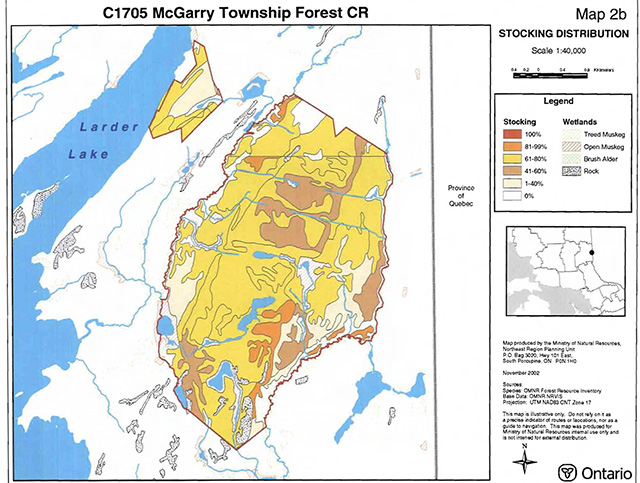
Enlarge Map: C1705 McGarry Township Forest CR Map 2b Stocking Distribution
Map: C1705 McGarry Township Forest CR Map 2c Age Distribution
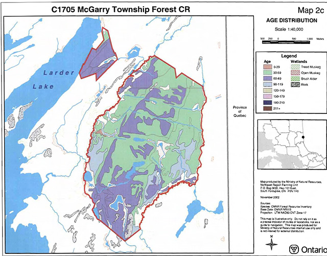
Map: C1705 McGarry Township Forest CR Map 2c Age Distribution
Map: C1705 McGarry Township Forest CR Map 3a Values
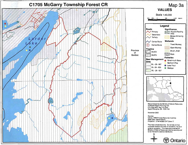
Enlarge Map: C1705 McGarry Township Forest CR Map 3a Values
Map: C1705 McGarry Township Forest CR Map 5 Old Growth
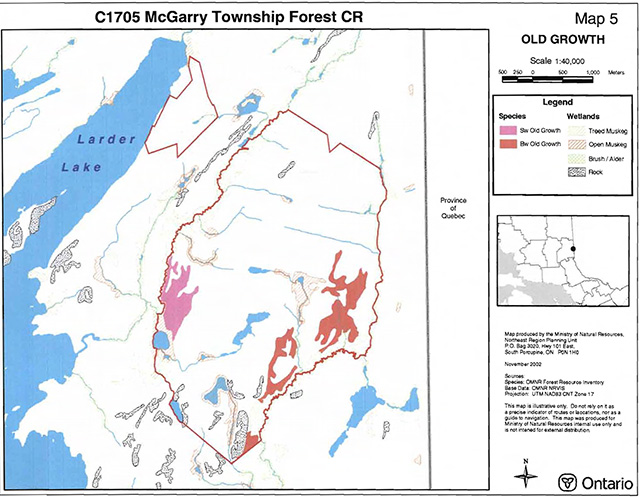
Enlarge Map: C1705 McGarry Township Forest CR Map 5 Old Growth
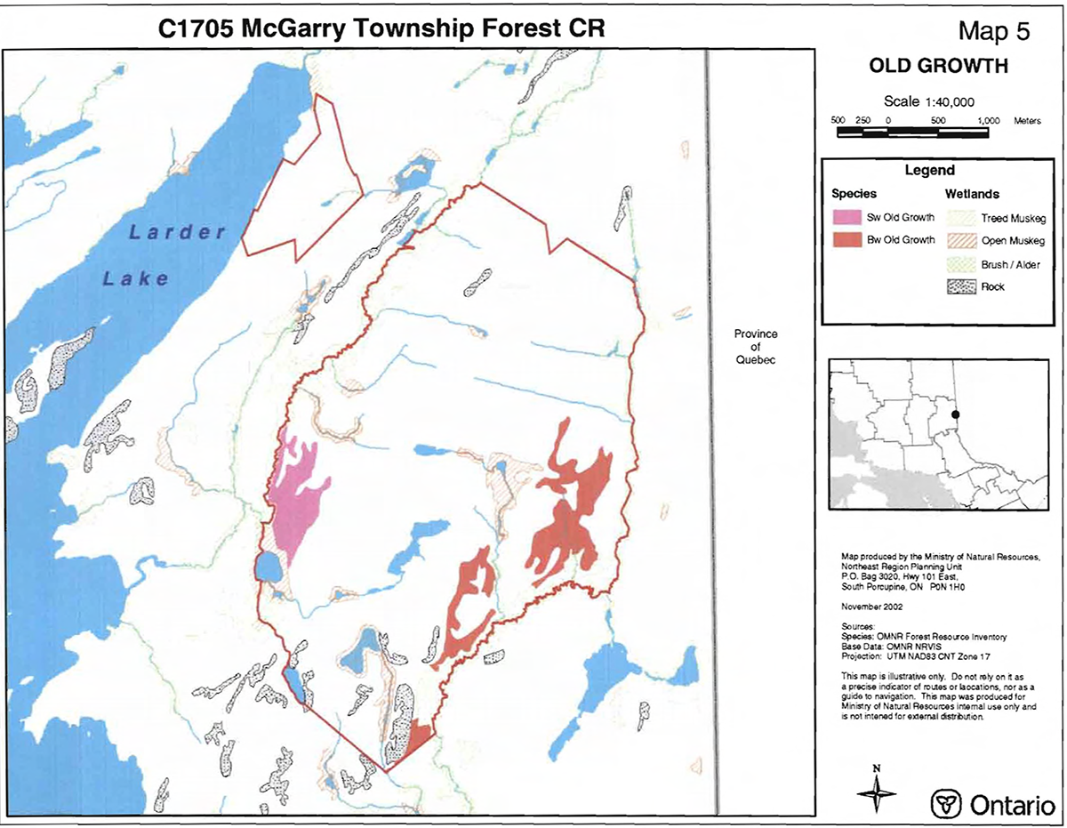
Appendix 9 - Earth Science Planning Summary
McGarry Township Forest (C1705)
Earth Science Inventory Checklist
| Name: | McGarry Township Forest |
|---|---|
| OLL ID: | C1705 |
| Map name: | |
| NTS Number: | 32 D/4 |
| UTM reference: | 090290 |
| OBM Number: | |
| Latitude: | 48°06' |
| Longitude: | 79°33' |
| Elevation – Max: | 500+ m |
| Elevation – Min: | 270+ m |
| County: | |
| Township: | McGarry, McFadde |
| Lot: | |
| Concession: | |
| Area (ha): | 1,643.00 |
| Ownership: | Crown |
| Air Photo (Year – Roll – Flight line – Number): | 1984 – 257 – 6 – 20-24 1984 – 255 –5– 118-121 |
| MNR region: | Northeast |
| MNR district: | Kirkland Lake |
| Park zone: | Northeast |
Earth science features
Bedrock is well-exposed in C1705, particularly along massive cliff faces and on the upper surface of large central ridges. It consists of the Coleman Member of the Gowganda Formation (Jackson 1995), including in part a conglomeritic sandstone/siltstone interpreted by many to be a tillite (a Precambrian glacial deposit). Talus slopes consisting of huge failed and slumped blocks of the tillite are common at the base of the cliffs. Surficial deposits consist of a thin discontinuous mantle of till and glaciolacustrine sediments.
Significance
The Gowganda Formation is well-represented in the protected areas system of the region. Its extensive exposure in C1705 provides excellent representation of the eastern facies of the Coleman Member of this unit, and are therefore considered to be provincially significant here. The surficial features of the site are not significant to the protected areas system.
Sensitivity
The bedrock geological features of the site are very resistant to most existing and intended uses.
Recommendations
An inventory of the location and description of the memebers of the Gowganda Formation in C1705 should be attempted during management planning.
Major references
Bedrock Geology: Mandziuk 1980 (OGS GR 204; Map 2445); Jackson 1995 (OGS Map 2628)
Surficial Geology: Baker 2000 (OGS Map 2647)
Dated Compiled:
10-May-01
Compiler:
PSG Kor
Ontario Ministry of Natural Resources, Ontario Parks
300 Water Street, Peterborough, Ontario K9J BN1
Detailed earth science features
The exposed bedrock geology in C1705 consists primarily of the Coleman Member of the Gowganda Formation, including in part a Precambrian sedimentary rock interpreted by many geologists to be derived originally from glacial (tillite) or glaciomarine deposits. The Gowganda Formation is part of the Southern Structural Province of the Canadian Precambrian Shield.
Bedrock topography dominates C1705, and consists of a broad central ridge dissected by joint or fault planes. These linear elements serve to dissect this central ridge into a number of spectacular mesa-like landforms. In addition, broad, concentric 'terraces' surround the main ridge, likely the result of differential erosion of the various rock types associated with the metasedimentary rock which dominates this area, the various undifferentiated members of the Gowganda Formation. Lakes are persched at several levels in this ridge complex. The ridge stands out quite dramatically in the regional landscape.
Quaternary deposits in C1705 consist of shallow pockets of glaciolacustrine clay and silt along the west flank of the bedrock ridge. Most of the site consists of bare bedrock (primarily the upper ridge area) or is mantled by a thin discontinuous deposit of glacial till.
Detailed significance:
Detailed major references
Baker, C.L. 2000. Quaternary Geology, Larder Lake Area; Ontario Geological Survey, Map 2647, scale 1:50000. Jackson, S.L. 1995. Precambrian Geology, Larder Lake Area; Ontario Geological Survey, Map 2628, scale 1:50000.
Mandziuk, Z.L. 1980. Geology of McFadden and Rattray Townships, Timiskaming District; Ontario Geological Survey, Report 204, accompanied by Map 2445, scale 1:31680.
Ontario Ministry of Resources
Ministere des Natural Richesses naturelles
Ontario Ministry of Natural Resources, Ontario Parks
300 Water Street, Peterborough, Ontario K9J BN1
Footnotes
- footnote[1] Back to paragraph The intent is that if this mining tenure is surrendered through normal processes, these areas will be added to the conservation reserve by way of regulation.
- footnote[2] Back to paragraph The intent is that if this mining tenure is surrendered through normal processes, these areas will be added to the conservation reserve by way of regulation.