Miles Bay Conservation Reserve Management Statement
This document provides policy direction for the protection, development and management of the Miles Bay Conservation Reserve and its resources.
Ministry of Natural Resources
Lake of the Woods Area
Kenora District
June, 2000
Updated April 7, 2011
Next Examination Due December 31, 2020
Prepared by: Kelli Saunders, M.Sc.
Resource Consultant Kenora, Ontario
Proj. 2000-2-1
Examination and adjustment history of management direction
Table of adjustment history of management direction
| Approval date | Examination or type of adjustment | Examination outcome | List of supporting documents |
|---|---|---|---|
| April 2, 2012 | Examination | Administrative Update |
|
Approval statement
I am pleased to approve this Statement of Conservation Interest for the Miles Bay Conservation Reserve.
This Statement of Conservation Interest provides guidance for the management of the conservation reserve and the basis for the ongoing monitoring activities. More detailed direction at this time is not anticipated. Should significant facility development be considered or complex issues arise requiring additional studies, more defined management direction, or special protection measures, a more detailed Conservation Reserve Management Plan will be prepared with full public consultation.
The public was consulted during the original regulation process and further consultation is not required at this time.
The conservation reserve will be managed under the jurisdiction of the Lake of the Woods Area Supervisor, Kenora District, Ministry of Natural Resources.
Charlie Lauer
Regional Director
Northwest Region
June 2, 2000
1.0 Background information
Miles Bay Conservation Reserve contributes to achieving the objectives of Ontario’s Provincial Parks and Conservation Reserves Act, 2006, including ‘to permanently protect representative ecosystems, biodiversity, and provincially significant elements of Ontario’s natural and cultural heritage’ and ‘to provide opportunities for ecologically sustainable land uses.
The purpose of this document is to identify the natural heritage values of Miles Bay Conservation Reserve, the activities which occur there and, through a set of management guidelines, outline the activities which will be permitted and those which will be prohibited. From this, the management direction for the area can be determined.
The Miles Bay Conservation Reserve is located on an unnamed island in Miles Bay of Lake of the Woods (see Figures 1 and 2). Being 44 ha in size, it is Crown-owned land that is home to old growth red and white pine stands and a variety of wildlife species. Interests on and around the island include a commercial outpost camp (Helliar’s Resort) on the northeast tip of the island (outside the boundaries of the Conservation Reserve) and several First Nation communities in the surrounding area. Those First Nations most directly linked to the resources offered on and near the island include Big Grassy, Big Island, Onigaming and Whitefish Bay, mainly related to subsistence and commercial fishing activities. Further background data are provided in the table below.
For more information for the basis of this Statement, please refer to the "Conservation Reserves Policy and Procedure PL3.03.05 (OMNR, 1997a), specifically pages 2-6 and 14-22 of the procedure.
Overview data describing Miles Bay Conservation Reserve and location
- Name: Miles Bay Conservation Reserve
- Site Region I Site District: 5S-1
- Ecosite Class: ES 11 (characterized by Red Pine-White Pine-Jack Pine forest and very shallow soil)
- OMNR Administrative Region/District/Area: Northwest I Kenora I Lake of the Woods Area
- Total Area (ha): 44 ha
- Regulation Date: July 9, 1997
- First Nations with Interest in Area: Big Grassy, Big Island; Onigaming, Whitefish Bay; Treaty 3
- OBM: 2015400054500
- Lat./Long.: 49°14N; 94°19W
- Basemap: 492942
- FRI Stands: Stand No. 47
- General Location Description: Unnamed island in Miles Bay of Lake of the Woods, approximately 62 km south of Kenora and 29 km southwest of Sioux Narrows.
- Access: The island is accessible by boat or float plane.
1.1 Targets
This section provides a summary of the earth and life science system and values, cultural resources represented and recreational opportunities available or possible.
Life Science Representation: Old growth red and white pine (mostly white pine).
Earth Science Representation: Shallow soils over bedrock.
Cultural Resource Representation: No documented cultural resources on conservation reserve (there are three cultural heritage sites within 1.5 km radius of the island).
Recreational Opportunities: Opportunities exist for day use activities, wildlife viewing, hiking, hunting, tourism and sport fishing on adjacent waters.
1.2 Survey information
This section provides an overview of the inventories completed, their level of detail and any further inventories required.
|
Survey Level |
Life Science |
Earth Science |
Cultural |
Recreational |
Other |
|---|---|---|---|---|---|
|
Reconnaissance |
No |
No |
No |
No |
1994 field survey Checklist |
|
Detailed |
No |
No |
No |
No |
Northwest Region Old Growth Report (1994 Old Growth survey) |
|
Requirement |
No |
No |
No |
No |
No |
2.0 Values to be protected
This section provides a description of the key natural heritage values on the site (Figure 3) and their condition relative to past resource use and management activities. It also addresses the values' sensitivity to future land use and management activities.
2.1 Values identified on the site
| Value | Details |
|---|---|
|
Life Science |
Old growth red and white pine community at northern fringe of this forest community’s northern range; site contains stands composed of approximately 20% red pine and 50% white pine at approximately 120 years of age (OMNR,1997b); contains some of the most diverse, undisturbed old growth red and white-pine stands on Lake of the Woods; little understory growth; some natural regeneration present. |
|
Earth Science |
Rugged terrain with shallow soils and some exposed bedrock. |
|
Cultural |
None identified. |
|
Aboriginal Interests |
None identified. |
|
Tourism |
Commercial outpost on northeast tip of island (Helliar’s Resort |
| Recreational Fishing | High profile recreational fishery in adjacent waters. |
| Recreational Hunting | Recreational and commercial hunting for bear and deer; part of Bear Management Area KE7A-10 (licensed to Mr. Michael Sergio, Black Island Resort). |
| Mining | Low mineral potential; no known mineral occurrences, exploration or stakin; no significant site concerns (MNDMF, Kenora, 1994). |
| Aggregate | None on site. |
| Forest Harvest | No commercial timber values on site. |
| Trapping | Part of a Big Grassy First Nation Reserve Trapping Area (KE 515). |
| Wild Rice | Not known to exist on site; closest wild rice site is approximately 0.2 km east of island. |
| Wildlife | Bear and deer are known to inhabit the island. During a site visit in 2010, four adult bald eagles (Special Concern) were observed on the island and appeared to be associated with two stick nests. Canada Warbler (Special Concern) was also observed on the island. Additional wildlife species observed on the island include Leopard Frog, Painted Turtle, Red-eyed Vireo, Northern Flicker, Winter Wren, Veery, Common Grackle, Yellow-rumped Warbler, Chestnut-sided Warbler, Yellow Warbler, Nashville Warbler, Mourning Warbler, White-throated Sparrow, Song Sparrow and Eastern Phoebe. |
| Commercial Fish | Baitfish license exists on adjacent waters; First Nations commercial and subsistence fishery in adjacent waters (mainly Big Grassy, Big Island, Onigaming and Whitefish Bay First Nations). |
2.2 Values to be protected
The intent of this Statement is to protect the above-mentioned values by establishing management guidelines for existing and potential uses in this area, given the level of past disturbance and the nature of the existing features.
Forest values
The forest of the entire island is to be protected from human disturbance for old growth red and white pine. The forest type is currently of red and white pine at approximately 120 years of age. It is expected to naturally maintain itself up to 250-400 years of age (at least another 50-150 years). It may be a source for genetic material for northern red and white pine genotypes. It may also provide for eagle and osprey nesting sites, as noted earlier in the documentation of an eagle’s nest in the rnid-1990s.
Recreational and commercial values
The sport and commercial fishing in adjacent waters and hunting opportunities on the island are recognized as well as the potential day use for hiking, swimming and viewing of waterfowl, eagles and wildlife.
Tourism values
The contribution of this unique and highly attractive area to local tourism is a significant value. Also recognized are the tourism opportunities provided by the outpost camp on the island.
3.0 Management guidelines
The following topics briefly describe the existing situation followed by the management guidelines to be implemented or continued.
3.1 Land tenure
The Miles Bay Conservation Reserve consists entirely of Crown land. As mentioned earlier, there is one commercial outpost Land Use Permit issued for Helliar’s Resort at the northeastern tip of the island. The earliest date of the permit issuance on record for this site is 1968. This one-acre parcel falls outside the jurisdiction of the conservation reserve. No disposition, by sale or Crown Lease or Land Use Permit, will occur within the conservation reserve.
3.2 Existing and proposed development
No development exists in the area; with the exception of the outpost camp. No development will be allowed that would disturb the forest including its understory.
3.3 Recreational activities
Sport fishing is allowed in adjacent waters; no sport fishing presently occurs on the island itself (no fishable water). Sport hunting will continue in the area. Activities such as snowmobiling and the use of all-terrain vehicles will generally be permitted to continue on the existing trail only where they do not adversely affect the values being protected. No new trails will be permitted. Other recreational activities such as hiking and wildlife viewing will continue to be permitted.
3.4 Commercial activities
The area forms part of a Big Grassy First Nation trapline; trapping will continue as a permitted activity. The area is presently part of a bear management area and no change is required at this time. As mentioned, only one commercial outpost exists on the island adjacent to the Conservation Reserve; no new ones will be permitted nor will other activities such as road construction, aggregate removal, mineral exploration and development or construction of utility corridors.
The area will be permanently removed from the operable Kenora Management Unit - Land Base and the area has been withdrawn from all mining exploration and extraction activities by the Ministry of Northern Development and Mines and Forestry (MNDMF) at MNR's request (see Appendix B).
3.5 Aboriginal interests
The Conservation Reserve is located within areas primarily used by the Big Grassy, Big Island, Onigaming and Whitefish Bay First Nations. Numerous First Nation communities, in addition to these, were consulted for comment during the public consultation program held in 1994/1995, but no response was received. Nothing in this Statement of Conservation Interest affects existing or future aboriginal or treaty rights.
3.6 Natural resources stewardship
3.6.1 Vegetation management
In recognition that fire is an important natural disturbance on the landscape, fire management of Miles Bay Conservation Reserve will be governed by the Lake of the Woods Fire Response Plan (OMNR 2007). This direction is consistent with the Forest Fire Management Strategy for Ontario (OMNR 2004a) and Fire Management Policy for Provincial Parks and Conservation Reserves (OMNR 2004b). As this conservation reserve is currently surrounded by high timber, wildlife and native values of the Kenora Management Unit and is adjacent to an outpost camp, it will remain as part of the MNR's intensive fire management zone. Fires will be aggressively suppressed.
There is a concern that this strategy may be in conflict with the ecosystem management objective for maintaining old growth red and white pine values (biodiversity, genetic heritage). Being a fire origin ecosystem, the exclusion of fire may contribute to the degradation of stand health (ecological maintenance and renewal) over time. There may be the opportunity for prescribed burn (low intensity fire for stand maintenance). However, the small size of this conservation reserve and the large cost of performing a prescribed bum would render it an unlikely candidate for this type of treatment. The allowance of natural fire is ruled out given the adjacent values of the area.
3.6.2 Fish and wildlife management
Nothing is required other than existing WMU and sport fishing regulation and management activities.
3.6.3 Landforms
There are no requirements except continued protection.
3.7 Cultural resources stewardship
There are no requirements at this time based on existing information.
3.8 Client services
Information about this conservation reserve should be made available to ensure that all resource users are aware of its location, its recognized values and permitted uses. Potential users include tourists and recreationalists (e.g. hikers, snowmobilers) as well as the general public and lake users who may use the island’s wood resource for fuelwood, personal use or for camping. Forestry and mining companies should also be made aware of the restrictions established for the conservation reserve, if they have not been already.
3.9 Research
Non-destructive research related to the study of old growth red and white pine communities will be encouraged in this conservation reserve.
3.10 Marketing
There are no requirements at this time.
4.0 Implementation
These-management guidelines will be implemented immediately by Kenora District. Any MNR Resource Management Plans or Land Use Plans which include this area will be amended accordingly. Any affected clients will be immediately informed of amendments to this management direction. Administrative responsibility for the conservation reserve rests with the Planning and Information Management Supervisor. Implementation will primarily involve providing public information and monitoring activities to ensure adherence to the management guidelines.
5.0 Review and revisions
5.1 Review and revisions
Methods of reviewing management direction will be consistent with the Protected Areas Planning Manual (OMNR 2009) and its associated guidelines. In accordance with the Provincial Parks and Conservation Reserves Act, 2006, MNR will annually examine management direction documents that have been in place for ten years or more. The next scheduled examination for Miles Bay Conservation Reserve will be in 2020.
5.2 Public consultation
5.2.1 Results of past consultation
Under the previous Keep It Wild Initiative, contact was made with First Nations, MNDM, the Northwestern Ontario Tourism Association and local communities in January, 1995. Newspaper advertisements and a district information package were distributed in the fall of 1994. At that time, concern was expressed regarding the establishment of the site as a Nature Reserve and its subsequent impact on traditional recreation and tourism activities. It was following this that the recommendation to designate the site a Conservation Reserve was made. No other concerns were identified with respect to the establishment of this reserve. Updated information to address any new concerns since 1995 was obtained for the purposes of this report through discussions with Ministry of Natural Resources staff, the Northwestern Ontario Tourism Association and Mr. Helliar, the owner of the outpost camp. No new information or concerns arose as part of these discussions.
5.2.2 Present and future consultation
More widespread consultation is not deemed necessary at this time because of the consultation which occurred in 1994 and 1995 (see section 5.2.1).
Author
This Statement of Conservation Interest was prepared by Kelli Saunders, M.Sc., Resource Consultant, Kenora,· Ontario.
6.0 References
[MNDM] Ontario Ministry of Northern Development and Mines. 1994. Letter consultation with C.E. Blackburn, Resident Geologist.
[OMNR] Ontario Ministry of Natural Resources. 1997a. Conservation Reserves Policy and Procedure. PL 3.03.05.
[OMNR] Ontario Ministry of Natural Resources. 1997b. Silvicultural Guide to Managing for Black Spruce, Jack Pine and Aspen on Boreal Forest Ecosites in Ontario. Book II: Ecological and Management Interpretations for Northwest Ecosites. Version 1.1. September 1997.
[OMNR] Ontario Ministry of Natural Resources. 2004a. Forest Fire Management Strategy for Ontario. Queen’s Printer for Ontario, Toronto. 64 pp.
[OMNR] Ontario Ministry of Natural Resources. 2004b. Fire Management Policy for Provincial Parks and Conservation Reserves. PL 3.03.09
[OMNR] Ontario Ministry of Natural Resources. 2009. Ontario Protected Areas Planning Manual. Peterborough. Queen’s Printer for Ontario. 50 pp.
Provincial Parks and Conservation Reserves Act. 2006. Toronto. 44 pp. [online].
Figure 1: Miles Bay Conservation reserve regional setting
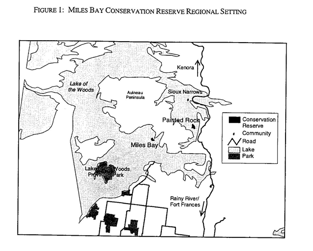
Figure 2: Miles Bay Conservation reserve boundary

Appendix A: Location map of commercial outpost camp
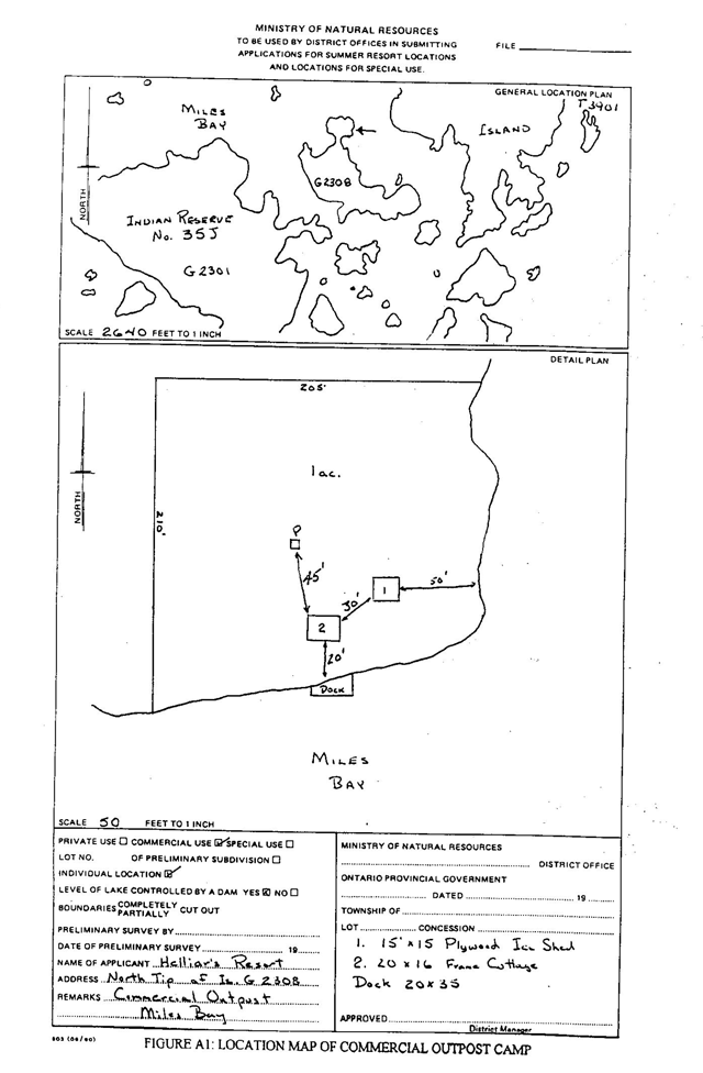
Enlarge Location map of commercial outpost camp
Appendix B: Mining act order withdrawn date and map
Footnotes
- footnote[*] Back to paragraph The one-acre commercial outpost camp, belonging to Mr. Wayne Helliar functions as a hunting and fishing camp according to conditions set out in a provincial-commercial outpost Land Use Permit. This permit was first issued in 1968 and was renewed again in April 2000. There is an annual fee associated with the permit. The locations of this camp, along with the allowable improvements on the site, are shown in Appendix A.