Ministry review of the St. Marys future solid waste disposal needs amended environmental assessment
Read our evaluation of the environmental assessment for a proposal to increase waste disposal capacity at the Town of St. Marys landfill site.
Environmental Assessment Act, R.S.O. 1990, subsection 7(1)
This review is subject to the provisions of Ontario Regulation 616/98 which sets out a deadline for the completion of this document. The deadline for the completion of the review was originally October 27, 2021 but was extended until February 3, 2023 to allow the Town of St. Marys to carry out additional technical studies, develop a new alternative, re-evaluate alternatives and make amendments to the environmental assessment in response to government review team comments received during the final environmental assessment comment period (first inspection period). This paragraph and the giving of the notice of completion are the notices required by subsection 7(3) of the Environmental Assessment Act.
The review documents the ministry’s evaluation of the St. Marys future solid waste disposal needs amended environmental assessment and takes the comments of government agencies, Indigenous communities and the public into consideration.
Summary of our review
Who
Town of St. Marys (Town)
What
The Town is proposing to expand the St. Marys Landfill (the landfill) to provide an additional 708,000 cubic metres (m3) of waste disposal capacity for post-diversion municipal solid waste. The undertaking will involve horizontal and vertical expansion of the landfill, and the realignment of 230 metres (m) of a watercourse running through the site. The expansion will increase the landfilling area by 3.2 hectares.
When
The St. Marys Future Solid Waste Disposal Needs Environmental Assessment was submitted on August 13, 2021. An amended environmental assessment was submitted on November 11, 2022.
Where
1221 Water Street South, St. Marys, Ontario
Why
The St. Marys Landfill reached its 380,000 m3 approved capacity in January 2016. Since then, it has been operating under an amended Environmental Compliance Approval from the Ministry of the Environment, Conservation and Parks (the ministry). The Town identified the opportunity to expand the St. Marys Landfill by 708,000 m3 in order to continue providing post-diversion municipal solid waste disposal services to St. Marys’ residents and its industrial, commercial and institutional sector until 2056.
Conclusions
Overall, the ministry determined that:
- the amended environmental assessment (EA) has been prepared in accordance with the approved terms of reference (ToR)
- the amended EA meets the requirements of the Environmental Assessment Act (EAA)
- the evaluation in the EA is sufficient to allow the Minister to decide whether to approve the proposed undertaking
Although the ministry noted changes between the ToR and the amended EA related to the consideration of waste diversion in the alternatives assessment and consultation program activities, the ministry is satisfied with the Town’s justification for each change from the ToR. The ministry determined that the amended EA was prepared in accordance with the approved ToR since section 10 of the ToR recognizes that circumstances during the preparation of the EA may necessitate some flexibility in how the EA is carried out.
The ministry has determined that the amended EA contains sufficient information to assess the potential environmental effects of the proposed undertaking. During the first public comment period, comments were received from Indigenous communities, government agencies, and the public concerning impacts to ground and surface water quality. In response to the comments, the Town undertook additional studies, developed a new alternative and updated its evaluation, amending the EA to reflect this work. As a result, an alternative watercourse realignment, enhanced monitoring, and an adaptive management framework have been included in the amended EA. The additional studies and revised evaluation undertaken by the Town, as documented in the amended EA, sufficiently address at this stage the comments and concerns raised by provincial ministries and agencies, Indigenous communities and the public during the first public comment period. The ministry proposes to recommend several conditions to the Minister that would, if the landfill expansion is approved to proceed, help to ensure that it would proceed as described in the amended EA and those with an interest continue to be informed.
1. Environmental assessment process
The Environmental Assessment Act (EAA) establishes a proponent-driven planning process designed to incorporate consideration of the environment into decision-making by assessing the effects of a proposed undertaking on the environment. The EAA sets out the requirements for the preparation of an EA, as well as the decision-making process following submission to the Ministry of the Environment, Conservation and Parks. The requirements of the EAA must be met before an undertaking can proceed.
Proponents are required to address the potential effects of the preferred undertaking on the natural, social, cultural and economic environment to ensure the protection, conservation and wise management of Ontario’s environment. The EA helps decision-makers to determine if an undertaking should proceed on the basis of the environmental effects — and if so, how the potential environmental effects can be managed.
An EA may:
- identify a problem or opportunity
- consider alternative ways of addressing the problem or opportunity
- evaluate the environmental effects of the alternatives
- select a preferred undertaking from the alternatives
The proponent must consider actions to avoid, reduce and mitigate potential environmental effects. In preparing the EA, the proponent completes various studies and consults with Indigenous communities, government agencies, and the public to evaluate the alternatives and determine the preferred undertaking. If the undertaking is approved, conditions may be imposed requiring the proponent to monitor the implementation of the undertaking to demonstrate compliance with the EAA, regulations and conditions of approval.
1.1 Terms of reference
The EA process involves two separate steps: the terms of reference (ToR) and the EA. The first step requires the proponent to prepare and submit a ToR to the ministry for review and decision by the Minister of the Environment, Conservation and Parks (Minister). The ToR is the work plan or framework for how the EA will be prepared.
The ToR for the St. Marys Future Solid Waste Disposal Needs Environmental Assessment was prepared pursuant to sections 6(2)(c) and 6.1(3) of the EAA. These sections allow the proponent to set out in the ToR the requirements for the preparation of the EA which may differ from the requirements set out in section 6.1(2) of the EAA, commonly referred to as the “generic” requirements for an EA. This allowed the Town to focus the assessment in the EA on identifying and assessing alternative designs (alternative methods) for the expansion of the existing landfill and assess potential environmental effects and benefits of the alternatives. The Town carried out a screening process as part of the ToR, the conclusion of which was that the preferred methods to address future solid waste disposal needs are:
- the development of new disposal capacity at the St. Marys landfill, or
- export of waste to another jurisdiction
The ToR was submitted in November 2012. The ToR was available for review by Indigenous communities, the public and government agencies for a 30-day period ending on December 24, 2012. In response to comments, an amended ToR was submitted to the ministry on January 13, 2014 and further amended through an errata letter submitted on February 25, 2014. The ToR was approved on December 29, 2014.
The ToR established the framework for the preparation of the EA, including:
- describing the purpose and rationale for the undertaking, which is to provide additional waste disposal capacity over a 40-year planning period
- identifying and evaluating potential environmental effects (both positive and negative) and proposing mitigation measures
- a consultation plan for obtaining input from Indigenous communities, the public and government agencies during the preparation of the EA
1.2 Environmental assessment
After receiving the Minister’s approval on the ToR, the Town proceeded to carry out the EA, which is to be prepared in accordance with the approved ToR.
After completing the EA, including consultation, the EA was submitted to the ministry for review and a decision by the Minister, which isis subject to the approval of the Lieutenant Governor in Council.
A draft EA was made available to Indigenous communities, the public, and government agencies on July 5, 2017 for a five-week period. On August 13, 2021, the Town submitted the St. Marys Future Solid Waste Disposal Needs Environmental Assessment to the ministry for review and a decision on the proposed undertaking. The EA was available for review by Indigenous communities, the public and government agencies during the comment period ending on October 1, 2021. During this period, Indigenous communities, the government review team (GRT) and the public had an opportunity to review the EA and submit comments to the ministry that will be considered by the Minister before making a decision.
The GRT — comprised of federal, provincial and local agencies — reviewed the information and conclusions in the EA based on the mandate of their respective agency. The GRT raised a few concerns, the most significant being potential impacts to the watercourse if relocated as proposed due to the proximity of a cement kiln dust (CKD) pile. In response to the concerns raised, the Town developed a new alternative that would result in the realignment of the watercourse for approximately 230 m instead of the originally proposed 780 m. The Town evaluated the new alternative using the established criteria, with the result that the new alternative became the preferred alternative. The Town also enhanced water quality monitoring commitments and developed an adaptive management framework to address any issues that might arise.
A draft amended EA was submitted to the ministry on September 12, 2022. GRT members who commented on the original EA were given an opportunity to review the draft amended EA and the Town’s responses to their concerns and provide any additional comments. The Town submitted the final amended EA to the ministry on November 11, 2022.
1.3 Ministry review
The EAA requires the ministry to prepare a review of the EA, known simply as the ministry review (review). The review sets out the ministry’s evaluation of the EA, including whether:
- the EA has been prepared in accordance with the approved ToR
- the EA meets the requirements of the EAA
- the evaluation in the EA is sufficient to allow the Minister to decide whether to approve the proposed undertaking
The review outlines whether the information in the EA supports the recommendations and conclusions for the selection of the proposed undertaking. Ministry staff, with input from the GRT, evaluate the technical merits of the proposed undertaking, including the anticipated environmental effects and the proposed mitigation measures. The review also provides an overview and analysis of public, agency and Indigenous community comments on the EA and the proposed undertaking submitted during the first comment period.
The Minister considers the review when deciding on the application. The Minister’s decision on the application will be made after the end of the five-week review comment period. The Minister’s decision is subject to the approval of the Lieutenant Governor in Council.
The review provides an opportunity for Indigenous communities, the GRT and the public to see how their concerns with the EA and the proposed undertaking have been considered During the review comment period, anyone can submit comments on the EA, the undertaking, or the review In addition, anyone can request that the Minister refer the EA, or any matter relating to the EA, to the Ontario Land Tribunal for a hearing Requests for a hearing can only be made during this comment period. The Minister will consider any requests for a hearing and, in accordance with section 9.3(2) of the Act, determine in their sole discretion whether a hearing is necessary.
A notice of completion of the review was issued advising that the review is available for a five-week comment period through the Government of Ontario’s website. Copies of the review have been distributed electronically to the GRT and identified Indigenous communities. Any members of the public who submitted a comment during the EA comment period have also received copies of the review.
2. The proposed undertaking
2.1 Background
The St. Marys Landfill is located at 1221 Water Street South in St. Marys, Ontario. The landfill is situated on 37 hectares (ha) of land owned by the Town and occupies 8 ha on the property. The current approved waste total waste disposal volume (or capacity) is 380,000 m3 and the site has an average annual fill rate of 13,500 m3 of solid waste per year. The landfill accepts industrial, commercial and institutional (IC&I) and residential waste.
The landfill has been operating since 1984 and currently serves as the Town’s only waste disposal facility. The Town leased the site from St. Marys Cement Co. (SMC) until 2009, at which time the Town purchased the property. The landfill reached its approved capacity of 380,000 m3 in 2016. Since then, the landfill has been operating under an amended Environmental Compliance Approval, originally issued in 2010.
2.1.1 Purpose of the undertaking
The Town proposes to increase the capacity of the landfill by 708,000 m3 for post-diversion municipal solid waste. The Town assessed its waste disposal needs over a 40-year period.
2.2 Study areas
The proponent identified two study areas: an on-site study area and the study area vicinity (Figure 2). The on-site study area includes the 37 ha St. Marys Landfill property located at 1221 Water Street South, St. Marys, Ontario. The study area vicinity includes a 1,000-metre radius around the on-site study area.
2.3 Local environment
The land around the landfill consists of agricultural properties, rural residential properties and the SMC plant. There are 16 residential properties within a 120-metre vicinity of the landfill. The Town of St. Marys’ Official Plan designates the landfill location as an Environmental Constraint area (designated to former and existing landfill sites and the Town’s sewage treatment plant). The County of Perth Official Plan identifies the land bordering the landfill to the south and east as Licensed Quarry Pit/Limestone Resource and Agricultural Lands and Natural Resources/Environment.
The topography in the area is relatively flat. However, historical industrial uses have impacted the land. The highest point on the site is the CKD pile at 334 metres above sea level (masl). The lowest point is the watercourse at around 306.8 masl.
The CKD pile, a remnant from past SMC operations, is located on the northeast section of the landfill property and is estimated to be 350,000–400,000 m3 (Figure 3 and Figure 4). A study of the pile carried out in 2005 found that the CKD pile itself contained contaminants at levels below ministry standards for all contaminants other than cadmium, which was above standards. Groundwater sampling found that groundwater in the area was alkaline with high amounts of sulphate, chloride, potassium and sodium. Selenium and silver exceeded standards, but no other substances exceeded standards.
A watercourse runs through the landfill property for approximately 780 m and then subsequently flows into the Thames River 250 m downstream of the property. Monitoring activities to date indicate that there are no impacts from the CKD pile or the landfill on the watercourse.
As part of the operation of the landfill, the site contains a leachate collection system, two stormwater management basins, access roads, a scale, and a scale house.
2.4 Description of the proposed undertaking
The proposed undertaking includes both a vertical and horizontal expansion of the landfill (Figure 3), increasing the capacity of the landfill by 708,000 m3 and providing capacity over a 40-year planning period ending in 2056. Expansion capacity was calculated based on landfill generation rates, waste diversion rates and population projections. The current landfill footprint (8 ha) would be expanded by 3.2 ha, for a total footprint of 11.2 ha. The expansion would involve the sequential creation of four new development cells (Figure 4). Cells 1 and 2 would be expanded vertically over and between the existing landfill footprint and Cells 3 and 4 would result in an eastward horizontal expansion. The description below outlines the proposed area and anticipated waste capacity for each of the 4 proposed cells:
- Cell 1 would have an area of 4.48 ha and total capacity of 165,000 m3. This cell would be expanded vertically and would not create a new footprint.
- Cell 2 would be expanded above the existing landfill footprint toward cell one. Its area (including overlap with cell 1) would be 3.46 ha and its total capacity would be 133,000 m3.
- Cell 3 would expand the landfill horizontally to the east with a capacity of 231,000 m3.
- Cell 4 would also expand horizontally to the east. Its area (including overlap with cells 1 and 3) would be 2.27 ha, and its capacity would be 176,000 m3. The expansion would involve excavation and grading.
Should the Minister approve the undertaking, construction is expected to begin in 2023, with operation spanning to December 31, 2056. The closure phase would begin in 2057 along with a 50-year post-closure care period.
The proposed landfill expansion would require the realignment of a section of a watercourse that runs through the landfill site and flows into the Thames River. Specifically, 230 m of the 780 m watercourse that runs through the landfill property will need to be realigned north to provide the space required for the proposed landfill expansion (Figure 3). The realignment would be carried out based on the dimensions and qualities of the existing watercourse and would use natural channel design principles. The EA indicates that subsequent approvals will be required and that the Town would rehabilitate new and existing sections of the watercourse by adding plants, habitat features and channel substrate and stabilizing the bank.
The landfill liner for the existing landfill footprint is made of natural clays on the site. Natural clay would also make up the liner for the expanded footprint. The clay is non-permeable and is expected to prevent most or all leachate from reaching the groundwater. Leachate is collected on-site through the leachate collection system and sent by sewer to St. Marys Wastewater Treatment Plant (WWTP). The leachate collection system would be extended into the new sections of the landfill. The Town determined that the existing WWTP has capacity to treat an increase in leachate should the landfill expansion be approved. Leachate from the landfill makes up just 1% of the treatment plant’s average daily flow and the plant is at 79% capacity.
The proposed undertaking includes replacement of two existing stormwater management basins with two new larger basins to the east and west sides of the site. The basins are designed to have capacity to handle a 250-year storm event. Ditches would be required between the access roads and the landfill for runoff to the basins. Channels would be built to direct stormwater from adjacent lands into the watercourse.
A two-lane access and maintenance road would be built along the northern side of the landfill. At the East Basin, a turn-around and a single-lane would proceed south to an existing road. The access road to the tipping face would require relocation or extension as operation progresses. The roads would be paved with gravel or recovered materials and maintained by the Town. The proposed expansion to the landfill footprint would also require relocation of the public drop-off and scale house on-site. The landfill expansion would use the same haul routes and site entrance.
Landfill operations currently include diversion programs for items such as leaf and yard waste, electronic waste, cardboard, blue box recycling materials and scrap metal. The Town reported diverting 1,782.37 tonnes of waste in 2018, with a diversion rate of around 33.8% that same year. While the Town has made improvements to its diversion programs, such as expanding curbside yard waste collection, offering discounts on backyard composters and implementing an e-waste collection program, there is still a need for general waste disposal.
If approval to proceed is given to the undertaking, the landfill expansion would be required to be completed in accordance with the amended EA and any conditions of approval; and will include the work outlined above. In addition, the Town would still be required to obtain all other permits and approvals it may require for the undertaking.

Figure 1: This map is a portion of the Ontario Road Atlas showing the approximate location of the St. Marys Landfill site (1221 Water Street South, St. Marys, Ontario) and street names within the broader area. The map shows the Town of St. Marys and the St. Marys landfill site located to the northeast of London and the northwest of Woodstock, just north of Highway 7.
Figure 2: This map shows the location of the St. Marys landfill, the on-site study area and the regional study area encompassing all lands within 1000 m of the landfill known as the “study area vicinity” at the southwest boundary of the Town of St. Marys. An area labelled as the study area vicinity is marked in a circular radius around the landfill site, exceeding the town boundary to the south and west. There are electrical distribution lines located to the north and northeast of the on-site study area inside the study area vicinity, and electrical transmission lines further away to the east outside the study area vicinity.
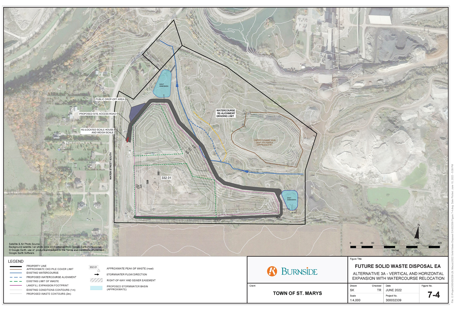
Figure 3: This figure shows the preferred alternative for the expansion of the St. Marys Landfill site: vertical and horizontal expansion with watercourse relocation. It includes the location and grading of the landfill expansion footprint; the CKD pile in the northeast portion of the property; the existing watercourse and proposed watercourse realignment; the proposed east and west stormwater management basins; and the proposed public drop-off area, site access road, and re-located scale house and weigh scale on the west side of the property.
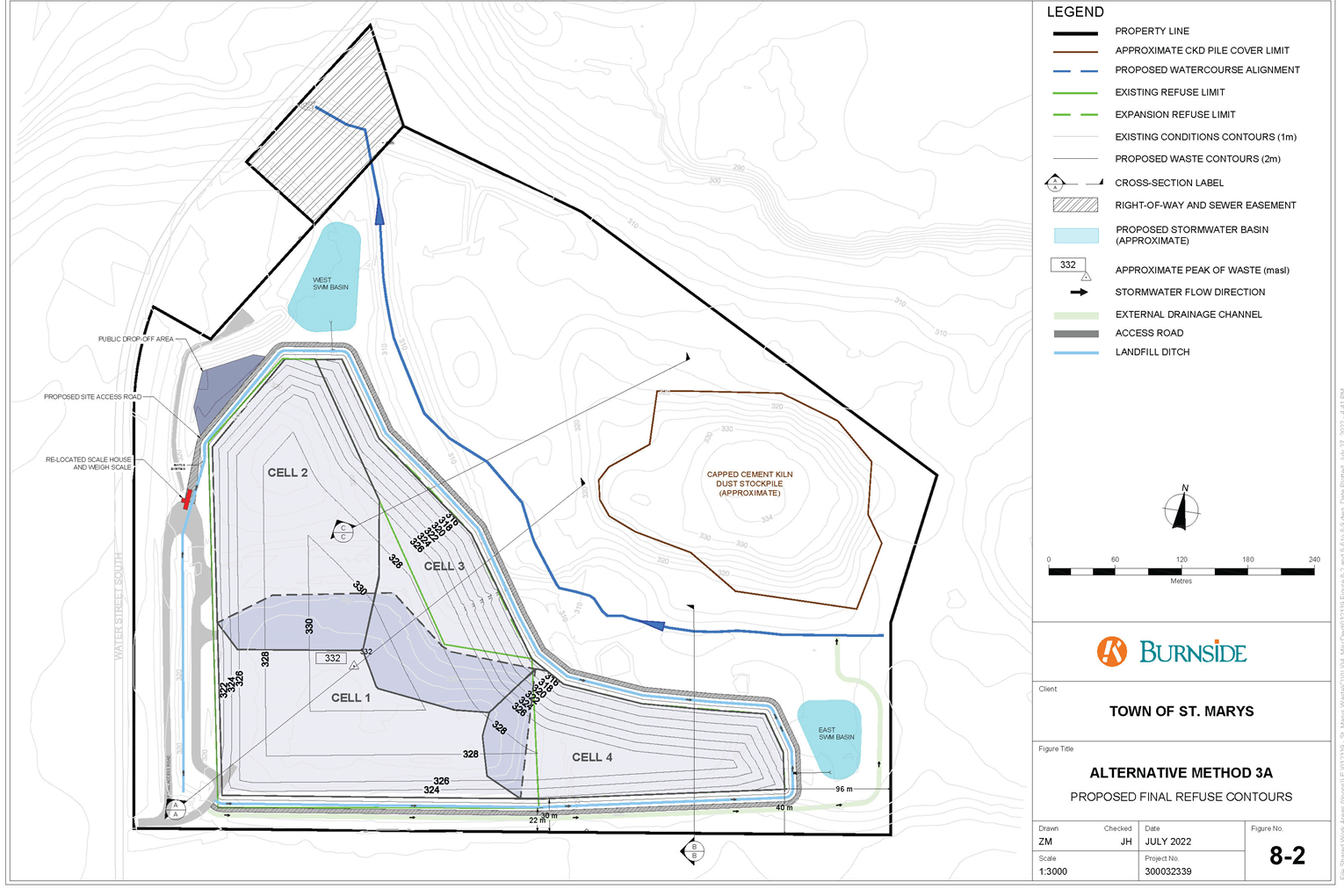
Figure 4: This figure displays the four proposed landfill expansion cells for the preferred alternative for the expansion of the St. Marys Landfill site. It includes an outline of the four landfill expansion cell contours, the CKD pile, the proposed new watercourse alignment, the proposed east and west stormwater management basins, and the location of the proposed public drop-off area, site access road, and re-located scale house and weigh scale on the west side of the property. Other features shown on the map are the existing refuse limit and proposed expansion refuse limit, right-of-way and sewer easement, landfill ditch, and an external drainage channel.
3. Results of the ministry review
The review provides the ministry’s analysis of the amended EA. It is not intended to summarize the amended EA, nor present the information found in the amended EA. For information on the evaluation process used to assess the alternatives, please refer to the amended EA itself. The amended EA and supporting documentation outline the EA planning process and demonstrate how the proponent has selected the preferred undertaking.
The purpose of the ministry review is to determine whether:
- the EA has met the requirements of the ToR and the EAA
- there are any outstanding issues with the EA
- the proposed undertaking has technical merit
Must haves in the EA:
- the EA must be prepared in accordance with the approved ToR
- the EA must include all the basic EAA information requirements
- the EA must demonstrate where all the additional commitments in the ToR were met, including studies and the consultation process
3.1 Conformance with ToR and EAA
3.1.1 Ministry analysis
The ministry coordinated an analysis of the amended EA with the GRT that, in part, looked at whether the EA was prepared in accordance with the ToR. The ministry has concluded that the EA meets the requirements of the EAA and the framework and commitments outlined in the ToR.
Appendix A summarizes the ministry’s analysis and identifies how the ToR and EAA requirements have been addressed in the amended EA.
The ministry noted changes between what was required per the approved ToR compared to what was provided in the EA related to the consideration of waste diversion analysis and consultation program activities. Section 10 of the ToR recognizes that circumstances during the preparation of the EA may necessitate some flexibility in how the EA is carried out. The ministry is satisfied with the proponent’s justification for the changes as the ToR provides sufficient flexibility, as noted above, for these changes. A summary of the ministry’s analysis of EA changes regarding waste diversion analysis is provided below and changes related to consultation program activities are included in section 3.1.2 (Consultation) of this review.
The ToR explains that although waste diversion is not a viable alternative to the undertaking, it would be explored further in the EA, including in relation to the alternatives to and alternative methods. Although the amended EA details the Town’s current and potential future waste diversion strategies, it does not discuss waste diversion in the context of the alternatives to or alternative methods. Subsection 3.1.3 (Required Disposal Capacity) of the amended EA and further communication between the ministry and the Town clarified that the impact of diversion rates on waste capacity for alternatives was estimated to be minimal and identified challenges in quantifying future waste reduction rates due to changing policy and technology. The Town commits to reviewing their operation and applicable diversion programs every 10 years and to implementing diversion targets set out in provincial policy. The ministry is satisfied with the commitments regarding waste diversion.
3.1.2 Consultation
One of the key requirements of the EAA is consultation during the preparation of the EA. This consultation is the responsibility of the proponent and must be carried out prior to the submission of the EA to the ministry and must be in accordance with the consultation plan outlined in the ToR.
Section 5.1 of the EAA states: “When preparing proposed terms of reference and an environmental assessment, the proponent shall consult with such persons as may be interested.”
The Town carried out its consultation program to inform and gain input from the GRT, members of the public, as well as Indigenous communities and organizations. The Town’s consultation program included:
- establishing a project contact list
- circulating notices for key project milestones by posting on a project website, sending directly to interested persons and agencies, and advertising in two local newspapers
- inviting interested Indigenous communities for a site visit
- meetings with Indigenous communities and organizations, agency and municipal stakeholders
- hosting two public information centres (PICs)
- distributing draft documents, including draft EAs to Indigenous communities and the GRT and posting documents on the Town’s website
The Town documented its consultation activities adequately in the amended EA and Record of Consultation. Section 10.0 (Consultation Summary) of the amended EA provides an overview of the consultation activities, with the complete consultation record documented in the Consultation Record Volume VI of the amended EA. Consultation was generally carried out as set out in the consultation plan in the ToR, with the exception that two PICs were held rather than three. The Town has explained through emails with the Ministry that the information originally intended to be discussed at the second PIC was completed earlier than anticipated and was therefore presented at the first PIC. This resulted in only two PICs being held. Section 10 of the ToR recognizes that circumstances during the preparation of the EA may necessitate some flexibility in how the EA is carried out. This includes modifications to the consultation program. The ministry is satisfied with the explanation for this change and that the information intended to be shared during the PICs was shared.
Following submission of the final EA to the ministry, the ministry provided the GRT, Indigenous communities and public with the opportunity to review the EA and to submit comments regarding the proposed undertaking and EA to the ministry, beginning on August 13, 2021 and ending on October 1. Comments received during the comment period were forwarded by the ministry to the Town for a response. In response to the comments received, the Town carried out additional technical studies and evaluation of the alternatives and amended the EA. The amended EA was submitted on November 11, 2022.
A summary of the comments received along with the Town’s responses are included in Tables 1-3 of Appendix B to this review.
Government review team
The government review team (GRT) was consulted throughout the EA process. This included opportunities to review and provide comments on work plans, draft technical studies, the draft EA, the final EA and the draft amended EA. The proponent also had several meetings with the ministry. The EA and Record of Consultation document how comments received from the GRT were addressed.
GRT agencies that provided comment on the final EA and draft amended EA include:
- Ministry of Environment, Conservation and Parks (MECP or ministry)
- Ministry of Citizenship and Multiculturalism (MCM) (previously Ministry of Heritage, Sport, Tourism and Culture Industries)
- Ministry of Natural Resources and Forestry (previously Ministry of Northern Development, Mines, Natural Resources and Forestry)
- Upper Thames River Conservation Authority (UTRCA)
- Impact Assessment Agency of Canada (IAAC)
- Fisheries and Oceans Canada
- CN Rail
- Huron Perth Catholic District School Board (HPCDSB)
- Huron Perth Public Health (HPPH)
- Hydro One Networks Inc.
- The Town of St. Marys Fire Department
All comments received from the GRT on the final EA and the draft amended EA were sent to the Town for response. These comments and responses are discussed in further detail in section 3.3 of this document and can be found in Appendix B.
Public consultation
The proponent used a variety of consultation methods to consult with the public including: public notices, two PICs and website postings. PICs were held on August 26, 2015, and June 23, 2016. A summary of consultation with public stakeholders during the preparation of the EA is included in section 10.0 (Consultation Summary) of the amended EA.
The notice of commencement for the EA was issued on February 9, 2015. The Town made the draft EA and its supporting documents available on the Town’s website to members of the public, agencies and Indigenous communities for comment from July 5, 2017 to August 10, 2017. The notice of submission of the final EA was issued on August 13, 2021 and circulated to the project contact list, as well as posted on the Town’s website for comment until October 1, 2021. The above-mentioned notices were also published in two local newspapers and sent to individuals and agencies on the project contact list.
The Town received a total of seven public comments, six during PICs and one during the final EA inspection period. Comments were predominately in regard to water quality, traffic, dust and odour. Public comments are discussed in more detail in section 3.3 of this review and can be found in Appendix B of this review.
Indigenous community consultation
The proponent also consulted with Indigenous communities during the EA process.
Aboriginal Indigenous rights stem from practices, customs or traditions which are integral to the distinctive culture of the Indigenous community claiming the right.
Treaty rights stem from the signing of treaties by Indigenous peoples with the Crown.
Aboriginal Indigenous rights and treaty rights are protected by section 35 of the Constitution Act, 1982.
The following Indigenous communities or representatives were identified for consultation purposes:
- Association of Iroquois and Allied Indians
- Métis Nation of Ontario
- Caldwell First Nation
- Walpole Island First Nation (WIFN) (Bkejwanong Territory)
- Chippewas of Kettle and Stony Point First Nation
- Oneida Nation of the Thames
- Chippewas of the Thames First Nation (COTTFN)
- Munsee Delaware First Nation
- Six Nations of the Grand River (through both the Six Nations of the Grand River elected council and the Haudenosaunee Confederacy Chiefs Council (represented by the Haudenosaunee Development Institute (HDI))
- Mississaugas of the Credit First Nation
- Moravian of the Thames Delaware Nation
- Aamjiwnaang First Nation (formerly Chippewas of Sarnia First Nation)
- Windsor Essex Métis Community Council
The Town consulted with the above identified Indigenous communities throughout the EA process. The proponent sent formal study notices at key project milestones via email or mail and followed up with each community with a phone call to ensure notices had been received and to solicit community comments.
The Town kept the above listed communities informed of the progress of the EA and provided links to EA documents and supporting materials for review and comment, such as work plans and reports. Some communities requested additional documents including archaeological assessment reports and annual monitoring reports which the Town provided. The Town met with communities that requested meetings including COTTFN, HDI and Six Nations of the Grand River. The Town also offered a site visit for communities in 2015, however none chose to attend.
Ministry staff made sure the draft and final EA were received by Indigenous communities, that the timelines for review were sufficient, and that comments from the Indigenous communities had been sufficiently addressed by the proponents through email and phone calls.
Indigenous community consultation is documented in section 10.0 (Consultation Summary) of the amended EA and section 4.5 and Appendix H of the Consultation Record. More detail on Indigenous consultation can be found in section 3.3 and Appendix B of this review.
Ministry conclusions on the consultation program
The EAA requires that the proponent consult with all interested persons during the preparation of the EA, provide a description of consultation activities undertaken by the proponent, and document consultation results. Overall, the ministry believes that the Town provided sufficient opportunities for public, stakeholder, government agency, and Indigenous community consultation during the preparation and finalization of the EA. The Town has committed to continued engagement with Indigenous communities throughout the life of the proposed undertaking. The Town has also committed to providing additional information and consulting with applicable GRT members.
The ministry is satisfied that the EA consultation undertaken is consistent with the Code of Practice for Consultation in Ontario’s EA Process and meets the requirements of the EAA. Taking into consideration the flexibility provided in the approved ToR, the ministry is satisfied that the consultation carried out is consistent with the ToR.
3.2 EA process
EA is a planning process that requires a proponent to identify a problem or opportunity, consider alternative ways of addressing the problem or opportunity, evaluate the potential environmental effects of alternatives against criteria, and select a preferred alternative based on the results of the evaluation. Overall, the Town followed a logical and transparent decision-making process to select the preferred method for expanding the St. Marys Landfill to address the opportunity to continue providing waste disposal services to 2056. Below is a summary of the EA process followed, including the study areas used, and the methods for assessing alternatives and environmental effects. Please refer to Appendix A of this review for the ministry’s analysis of how the amended EA has met the requirements of the EAA and has been prepared in accordance with the approved ToR.
3.2.1 Focused EA
The Town prepared its amended EA in accordance with sections 6(2)(c) and 6.1(3) of the EAA, which resulted in an amended EA that “focused” on alternatives for increasing waste disposal capacity at the St. Marys Landfill.
The ToR explained that the Town had a limited number of reasonable ways to address the problem of securing additional disposal capacity. An initial screening of “alternatives to” was carried out as part of the ToR based on existing information and using the criteria set out in the ToR. The “alternatives to” identified and included in the screening are:
- do nothing
- enhance waste diversion
- energy from waste
- export of waste to another jurisdiction
- landfilling at a new landfill site in St. Marys
- expansion of the existing landfill site in St. Marys
Following this screening, the exporting waste to another jurisdiction, expansion of the existing landfill site and do nothing alternatives remained and were examined further in the EA. Expansion of the existing landfill was selected as the preferred alternative based on the further screening carried out during the EA. The alternative methods of expanding the landfill were then examined in detail in the EA.
3.2.2 Study areas
As described in section 2.2 of this review, the amended EA identifies two study areas: the on-site study area (the St. Marys landfill property) and the study area vicinity (1,000 m radius around the site). Section 6.0 (Phase 4: Define the Parameters of the Study) of the amended EA provides a description of the environmental conditions within these study areas to establish a baseline for comparison with alternative methods. The environments described in the amended EA are:
- natural environment — air quality and odour, noise, groundwater, surface water, ecology
- cultural environment — built heritage resources and cultural landscapes, archaeological resources
- transportation
- land use
- socio-economic environment — employment, social conditions
- Indigenous communities and treaty rights
The ministry is satisfied that a broad definition of the environment was considered and that the amended EA adequately describes the existing environmental conditions in the study areas.
3.2.3 Assessment of alternative methods
The Town considered alternative methods of expanding the existing landfill in section 7.0 (Phase 5: Assess Alternative Methods for Carrying Out the Undertaking) of the amended EA. The Town developed evaluation criteria and indicators to identify and assess the impacts of these alternatives on the natural (biological and physical), cultural, built and socio-economic environments. The Town predicted the net effects for each alternative method, then compared and ranked each method to determine the preferred option. The options for expanding the landfill to provide additional waste disposal capacity were:
- Alternative 1 — Vertical expansion of the existing landfill
- Alternative 2 — Horizontal expansion of the existing landfill (with watercourse relocation)
- Alternative 3 — Combination of vertical and horizontal expansion (with watercourse relocation)
- Alternative 3A — Combination of vertical and horizontal expansion (with watercourse realignment) (added in amended EA)
- Alternative 4 — Development of a new landfill footprint
- Alternative 5 — Vertical expansion plus a new footprint
Alternative 3 was originally selected as the preferred alternative based on its high ranking for factors like social conditions, cultural and environmental factors, odour, and financial factors. However, the planned relocation of the watercourse necessitated by this alternative resulted in issues regarding encroachment onto SMC land, and concerns (GRT and Indigenous Community) over potential water quality impacts from the CKD pile. As a result, Alternative 3A was developed and was evaluated and documented in the amended EA. Alternative 3A, which involves realignment of a portion of the watercourse rather than relocation, was evaluated to be the preferred alternative as it has many of the same benefits of Alternative 3 but with a reduced impact on groundwater and surface water quality, terrestrial and aquatic ecology. It is also less expensive.
Alternatives 1 and 4 and the “do nothing" alternative were ruled out because they would not result in a sufficient landfill capacity for the 40-year planning period. Alternative 2 was not feasible because it would encroach onto SMC land similar to Alternative 3. Alternative 5 ranked poorly for its impact on odour, groundwater, surface water and aquatic ecology and was predicted to be the most expensive alternative based on both capital costs, and operational and maintenance costs.
3.2.4 Assessment of environmental effects
The amended EA describes the potential effects, mitigation measures and residual (net) effects of the overall landfill expansion project in section 9.0 (Potential Impacts, Mitigation Measures, and Net Effects) of the amended EA. The Town developed impact assessment criteria which were used to identify the net effects resulting from the project after the application of mitigation measures. The environmental components considered include:
- air quality
- odour
- noise
- hydrogeology
- surface water quality
- surface water quantity
- terrestrial ecology
- aquatic ecology
- built heritage resources and cultural heritage landscapes
- archaeological resources
- local transportation
- sensitive land use
- aggregate resources
- social conditions
- Indigenous communities
Environmental components with residual effects after mitigation are:
- air quality
- odour
- noise
- hydrogeology
- groundwater
- surface water quality
- aquatic ecology
- social conditions
The amended EA also indicates that there may be potential impacts on environmental features that are culturally or environmentally significant to Indigenous communities. Effects could include dust, odour, construction and closure-related noises and increased risks to groundwater, surface water and aquatic ecology associated with leachate, the CKD pile and the realigned watercourse. Changes to water quality in the watercourse could impact the Thames River downstream. The river is a culturally significant feature to some Indigenous communities. As well, there are expected impacts to social conditions such as minor changes in air quality, noise, odour, vermin and litter levels and slight alterations to the view. All net impacts have a low risk of occurring and/or are expected to be minor. Air, odour and noise-related impacts are not expected to change significantly from current landfill operations and air emissions and noise will be within provincial guidelines. The corresponding impact to social conditions is expected to be minor. The amended EA found the risk to surface water quality was expected to be low due to mitigation and monitoring efforts and that there was a minor increase in risk of effects to hydrogeology after mitigation. Similarly, the risk of impacts to aquatic ecology is expected to be low after mitigation and monitoring. As a result, the amended EA also concluded there is a low risk of impacts to features that are culturally or environmentally significant to Indigenous communities.
Source water protection
Source water protection is addressed in subsection 3.7.1 (Existing St. Marys Landfill) of the amended EA. The project is located in the Thames-Sydenham and Region Source Water Protection Area. The landfill site is not located in any Wellhead Protection Areas or Intake Protection Zones and has no Significant Groundwater Recharge Areas. A section of the northeast corner of the landfill site has been identified as a Highly Vulnerable Aquifer, likely due to historical quarrying by SMC. The landfill’s water quality monitoring program has not identified any concerns with drinking water quality in neighbouring wells.
Climate change impacts
The amended EA outlines how the proposed undertaking will impact climate change and how climate change will impact the undertaking. The primary impact the landfill will have on climate change is through landfill gas (LFG) emissions. LFG is a greenhouse gas (GHG) primarily made up of carbon dioxide and methane, which contribute to climate change. It is caused by the decomposition of landfill waste. Due to the landfill’s small size, it does not meet the regulatory threshold requiring the installation of an LFG capture and destruction system. As well, the expected fill rate is low, and therefore the LFG generation rate is expected to be low.
The landfill expansion is predicted to produce around 2,000 tonnes of CO2 per year or 79,000 tonnes of CO2 over the entire 40-year planning period. Annually, the project would contribute around 0.24% to Ontario’s yearly solid waste GHG emissions and 0.001% of Ontario’s yearly total GHG emissions. Annual project emissions would make up around 0.004% of Canada’s yearly solid waste GHG emissions and 0.0003% of Canada’s total annual GHG emissions.
The stormwater management system for the proposed undertaking has been designed for severe weather events. The site is designed with slopes of 25% or under to prevent erosion.
The Town is planning the landfill expansion in a manner that considers future changes in climate and the impacts a changing climate could have on the project. The net effects of greenhouse gas generation are considered in the amended EA as well as the size/design of stormwater management facilities to address potential flooding events. The project is not expected to have any significant impacts on the environment due to climate change considerations.
Cumulative effects
The Code of Practice for Preparing and Reviewing Environmental Assessments in Ontario (2014) encourages proponents to include information about the potential cumulative effects of the project in combination with past, present and reasonably foreseeable future activities. The amended EA identified activities that could act together with the effects from the proposed landfill expansion, such as aggregate extraction, agriculture and traffic. The Town assessed cumulative effects on environmental components, excluding any environmental components with no net effects. Some of the cumulative effects identified include dust, odour and impacts to surface water, groundwater and aquatic ecology. Cumulative effects are expected to be minor. The Town has listed mitigation measures in Table 9-1 (Effects, Mitigation Measures and Net Effects) of the amended EA to limit these effects.
3.2.5 Monitoring and commitments
Sections 9.0 (Potential Impacts, Mitigation Measures, and Net Effects) and 11.0 (Commitments and Monitoring) of the amended EA describe environmental effects monitoring activities to ascertain the effectiveness of mitigation measures, in addition to contingency measures to address unexpected occurrences. Monitoring activities are proposed for ground and surface water, off-site nuisance effects, leachate, bank stability, planted vegetation survival, access roads, trapped fish and public complaints. Contingency measures are provided in case of leachate control system failure, watercourse contamination from the CKD pile material and LFG odour and spills. Commitments related to the construction, operation, closure and post-closure of the expanded landfill are listed in Table 11-1 (Summary of EA Commitments) of the amended EA.
3.2.6 Conclusion
Overall, the ministry is satisfied with the proponent’s decision-making process, and that the process used is consistent with the requirements of the EAA. The ministry is also satisfied that the amended EA was prepared in accordance with the ToR approved by the Minister. Where the consultation program varied from the ToR, the ministry is satisfied with the proponent’s reasoning for the changes and that the ToR contained sufficient flexibility to allow for such changes.
The amended EA:
- confirms the need to find additional waste capacity
- provides a description of the environment potentially affected which considers the EAA’s broad definition of environment
- considers alternative methods for expanding the landfill
- identifies the potential effects of alternatives along with mitigation measures and assesses them based on their relative advantages and disadvantages
- identifies net effects of the project and proposes monitoring measures to manage environmental effects
3.3 Comments on the proposed undertaking
3.3.1 Key issues
Key issues or comments regarding the proposed undertaking provided by Indigenous Communities, the GRT, and the public during the EA review and comment period that followed the submission of the EA are set out in Tables 1-3 of Appendix B along with the responses provided by the Town and the ministry’s level of satisfaction. A summary of the issues or comments is set out below.
Government review team
GRT members commented on the EA during the seven-week inspection period for the final EA and later during a review of the draft amended EA. The most significant GRT comments on the final EA were raised by MECP and Upper Thames River Conservation Authority (UTRCA) over potential water quality issues associated with the original preferred alternative (Alternative 3). The agencies raised concerns over the potential adverse impacts the CKD pile could have on water quality considering the length of the watercourse relocation and proximity of the watercourse to the pile. To address these concerns, the Town developed and evaluated a new alternative (Alternative 3a), which would necessitate realigning the watercourse for approximately 230 m instead of the originally proposed relocation of 780 m of the watercourse. The Town also included enhanced water quality monitoring commitments and developed an adaptive management framework in the amended EA to address any issues. MECP and UTRCA were satisfied with the new preferred alternative and associated commitments. The ministry is considering recommending a condition of approval requiring the proponent to submit a water quality monitoring and contingency plan with respect to potential effects of the CKD pile on the watercourse to the MECP and UTRCA.
MECP’s other comments related to EA requirements, Indigenous consultation, and mitigation measures for species at risk. The proponent addressed these comments through changes to the EA, including identifying both positive and negative effects when assessing alternatives and adding more detail on decision-making factors. The proponent also provided more detail on Indigenous consultation and committed to ongoing Indigenous consultation. As well, the proponent added text acknowledging the presence of Eastern Meadowlark habitat and committed to surveying the site for Bank Swallows before site alteration. After reviewing the draft amended EA, MECP technical experts requested that mitigation measures for Bank Swallows be implemented during landfill construction and operation; and the Town updated the amended EA with a commitment to do so. MECP technical staff indicated they are satisfied their comments have been addressed in the amended EA.
UTRCA’s comments focused on species at risk, channel design principles, impacts to drinking water, landowner permission and Conservation Authority regulatory requirements. UTRCA requested that draft copies of a stormwater management report, a sediment and erosion control plan and a channel design brief be submitted to the UTRCA for review prior to the issuance of subsequent MECP approvals. In addition, UTRCA requested continued consultation on the project. The Town addressed UTRCA’s comments by adding more information on potential impacts to wildlife and habitat and information on stormwater management in the amended EA. The Town also committed to further water quality monitoring and to consulting with UTRCA during detailed design. UTRCA advised MECP that it is satisfied with the draft amended EA and the responses to its comments, provided that UTRCA receives the documents requested. Though the proponent committed to submitting the requested documents, the ministry is considering recommending a condition of approval requiring the submission of the requested documents to the UTRCA and MECP.
MCM suggested administrative changes to EA content and requested that the proponent carry out an archaeological assessment if any part of the proposed undertaking falls outside of the study area. The Town updated the EA and committed to an additional archaeological assessment if the need arises and made the additional changes MCM suggested where appropriate. MCM indicated it was satisfied with the proponent’s responses.
Fisheries and Oceans Canada (DFO) advised the proponent on preventing and mitigating impacts to fish and fish habitat and requested that they be notified a minimum of 10 days before project work begins. In response, the Town committed to notifying DFO at least 10 days before construction, obtaining applicable permits from DFO and providing DFO with a watercourse realignment plan for review and approval. DFO indicated that it was satisfied.
CN Rail identified concerns with the risk of dust impacts in nearby rails when reviewing the draft amended EA due to proximity of the landfill. CN sought a 50 m setback between the landfill and rail lines and wanted to ensure that the Town was aware of Mining Near Lines of Railways Regulations. The Town responded that they were aware of the regulations and that the landfill was approximately 900 m away from the nearest rails and no impacts were expected. CN Rail was satisfied with this response.
Huron Perth Public Health (HPPH) did not voice significant concern over the amended EA, but requested to be notified of any signs of impacts to public health. The ministry is considering recommending a condition of approval requiring the Town to develop a complaints response protocol in consultation with HPPH.
Public
During the EA process, key issues and concerns raised through consultation activities with public stakeholders included:
- drinking water quality
- odour and dust
- thermal treatment alternatives
- traffic
The EA assessed impacts to hydrogeology when considering alternative methods and determined that the preferred alternative would result in a minor increase in risk to groundwater quality. Regarding concerns over odour and dust, odour is predicted to have a minor increase with the expansion and mitigation measures will be put in place to limit impacts from dust. Thermal treatment was suggested as an alternative, however it was considered in the ToR phase and discarded due to financial and technical constraints. Lastly, in response to a concern over traffic speeds if the landfill entrance was to be relocated, the Town initiated a traffic impact study which projected that conditions would be safe.
There was one comment from a member of the public during the formal comment period for the final EA. The individual expressed support for the proposed undertaking.
Indigenous communities
Several Indigenous communities submitted comments during the EA process. The Town met with HDI on February 29, 2016. Upon reviewing the final EA in September 2021, HDI requested involvement in various steps of the EA process such as studies, archaeological reports, permits, the stormwater management plan and the erosion and sediment control plan, among others, and requested site inspections. HDI requested that the Town allow an HDI Environmental Division or Archaeological Division representative to monitor field work and site inspections. The Town was open to HDI participation and committed to continue to engage with HDI and other Indigenous communities. Finally, HDI raised concerns over the relocated watercourse proposed in the EA. As noted above, in response to the concerns raised regarding the relocation of the watercourse, the Town developed a new alternative. The Town also enhanced water quality monitoring commitments and developed an adaptive management framework.
In September 2015, the Chippewas of Kettle and Stony Point First Nation informed the Town that the proposed undertaking would impact their traditional territory and that they would like to continue to be consulted but did not have significant concerns. The Town committed to keeping the First Nation informed and continuing to consult with the community throughout the EA process. The Town committed to continuing engagement with Indigenous Communities throughout project implementation.
During a February 4, 2014 meeting between Chippewas of the Thames First Nation (COTTFN) and the proponent, COTTFN expressed concerns about impacts to water quality downstream of the landfill in the Thames River, especially with respect to their ability to fish and hunt. COTTFN requested annual monitoring reports which the proponent provided. During the final EA inspection period, COTTFN did not raise concerns with the EA but requested to remain informed. The proponent committed to ongoing consultation with COTTFN and other Indigenous Communities throughout project implementation.
During the final EA review period, Six Nations of the Grand River raised questions concerning the landfill lining, landfill gas and of particular concern, tree removal. Six Nations of the Grand River requested a 10:1 ratio be used for any trees removed as part of the undertaking. The Town responded to the questions and committed to a 10:1 tree replacement ratio. In addition, the Town committed to continued consultation with Six Nations of the Grand River and other Indigenous Communities throughout project implementation.
During the EA review period, Walpole Island First Nation (WIFN) requested yearly meetings with the Town to discuss annual reports and impacts to the community. Additionally, WIFN raised concerns over cumulative effects. The Town committed to yearly meetings with WIFN and to exploring any benefits and opportunities the landfill might offer the community.
3.2.2 Conclusion
The Town provided responses to all comments received during the EA submission comment period. Ministry staff are satisfied with the proponent’s consultation efforts and commitments to address comments and concerns received.
4. Other considerations
4.1 Diversion
The EA explains that the St. Marys Landfill serves as the sole waste disposal facility for the Town and outlines recent waste diversion facilities added to the landfill, including an area for the composting of leaf and yard waste, a municipal hazardous and special waste (MHSW) facility, and a waste transfer station for acceptance of electronic waste (e-waste), cardboard, scrap metal and blue box recycling materials.
The Town is also a member of the Bluewater Recycling Association (BRA) which is a non-profit dedicated to enhancing waste diversion efforts at 20 municipalities. As a member of BRA, the Town of St. Marys operates a multifaceted program to divert waste, including:
- automated curbside collection
- leaf and yard waste collection
- scrap metal recycling
- blue box recycling
- electronic waste recycling
- concrete and asphalt recycling
- wood and brush grinding.
The Town operated a municipal hazardous and special waste depot until March 2020. A 2018 Waste Reduction and Diversion Assessment carried out by the Town found that the waste diversion efforts resulted in a total of 7,320 tonnes of waste being diverted. The Town diverted 1,782.37 tonnes of waste in 2018.
The Town has identified eight waste reduction or diversion programs it could consider adopting in the future, including:
- food and organics collection
- cigarette waste recycling program
- asphalt shingles recycling program
- mattress and box spring program
- landfill optimization
- backyard composting initiatives
- textile recycling
- IC&I diversion
The Town predicts that these diversion efforts, along with provincial policy and trends towards manufacturing reductions in packaging, would increase the Town’s waste diversion rates.
According to the amended EA, future diversion rates were not projected due to uncertainties in which diversion strategies will be implemented in the future. However, the Town expects that the impact of waste diversion on disposal capacity will be minor. The Town committed to review available diversion programs every 10 years and meet any future diversion targets set out in provincial policy.
5. Summary of the ministry review
The ministry review has explained the ministry’s analysis of the amended EA.
This ministry review concludes that:
- The amended EA was completed in accordance with EAA requirements. The ToR provided flexibility to make certain modifications if necessary due to changes in circumstances between the submission of the ToR and the EA. The proponent provided adequate explanation to the ministry for changes noted.
- Sufficient opportunities were provided for the Indigenous communities, the GRT, and the public to comment during the development of the EA. Concerns raised by Indigenous communities, the GRT and public have been considered and addressed by the proponent in the amended EA or through proponent commitments.
- The amended EA has:
- assessed and evaluated alternative methods to arrive at the preferred undertaking
- assessed the potential environmental effects of the alternative methods and the proposed undertaking
- assessed the advantages and disadvantages of the preferred alternative, and provides a description of mitigation and monitoring measures to address the potential negative environmental effects of the proposed undertaking
- The amended EA provides sufficient detail on the EA process, the proposed undertaking and the potential impacts of the undertaking for the Minister to make a decision.
Overall, the ministry is of the opinion that the St. Marys Landfill expansion would be designed and operated to comply with the ministry’s standards and that the environmental effects of the proposed undertaking can be managed through the commitments made in the EA, through conditions of approval, or through additional work that must be carried out by the Town in support of future approval applications, if the amended EA is approved. The conditions of approval being considered by the ministry are summarized below in section 5.1.1 of this review
5.1 Proposed conditions of approval
The ministry proposes to include several standard conditions of approval should the undertaking be approved to proceed. These conditions include:
- general requirements to implement the undertaking in accordance with the amended EA and commitments made
- documentation requirements for the public record
- compliance monitoring provisions for the proponent to conduct and report on
- preparation of a complaints protocol to respond to all complaints received during construction and operation
- preparation of an Indigenous consultation plan for project implementation
- an expiration date for the amended EA approval
Below is a preliminary list of potential conditions of approval being considered for recommendation to the Minister to further support the commitments made in the amended EA. The proposed supplemental conditions include a requirement to:
- submit a water quality monitoring and contingency plan to the MECP addressing potential effects of the CKD pile during the construction, operation, closure and post-closure phases
- submit a stormwater management plan, sediment and erosion control plan, channel design brief and an updated hydrogeological study to the MECP and UTRCA
- develop a complaints response protocol in consultation with HPPH, for submission to the MECP
During the five-week review comment period and prior to the ministry making a recommendation to the Minister about this EA, additional conditions of approval specific to the landfill expansion undertaking may be proposed to ensure that the environment remains protected.
6. What happens now
The review will be made available for a five-week comment period. During this time, all interested parties, including Indigenous communities, the GRT and the public can submit comments to the ministry about the proposed undertaking, the amended EA and/or the review. At this time, anyone can make a written request that the Minister refer either all or part of the amended EA to the Ontario Land Tribunal for a hearing.
Following the review comment period, ministry staff will make a recommendation to the Minister regarding approval of the undertaking. When deciding whether to give approval to the undertaking, the Minister will consider the requirements set out in the EAA, including:
- the purpose of the EAA
- the amended EA
- the review of the EA
- comments received during the formal comment periods
- other matters the Minister may consider relevant
The Minister will make one of the following decisions:
- give approval to proceed with the undertaking
- give approval to proceed with the undertaking subject to conditions
- refuse to give approval to proceed with the undertaking
Prior to making that decision, the Minister may also refer either part of or the entire EA to mediation or refer either part of or the entire EA to the Ontario Land Tribunal for a decision.
If the Minister approves, approves with conditions, or refuses to give approval to the undertaking, the Lieutenant Governor in Council must concur with the decision.
6.1 Additional approvals required
If EAA approval is given, the Town must still obtain any other permits or approvals required for the design, construction and operation of the undertaking.
Section 10 of the EA outlines the additional approvals that may be required which include:
- Environmental Protection Act — approval for landfill expansion
- Ontario Water Resources Act — approval for revised site surface water management system
- Conservation Authorities Act — watercourse realignment and outlets for the stormwater ponds in a UTRCA Regulated Area
- Endangered Species Act — impacted Eastern Meadowlark habitat
- Fisheries Act — in-water work in the watercourse that could result in harmful alteration, disruption or destruction of fish habitat downstream in the Thames River
- Fish and Wildlife Conservation Act — Wildlife Scientific Collector Authorization for any wildlife relocated during construction
These approvals cannot be issued until approval under the EAA is granted.
6.2 Modifying or amending the proposed undertaking
Any changes to the undertaking outside the scope of this EA may be considered a new undertaking pursuant to section 12 of the EAA and may require the completion of a new individual EA or the Environmental Screening Process in accordance with Ontario Regulation 101/07 (Waste Management Projects) made under the EAA.
Making a submission
A five-week public review period ending on July 7, 2023 will follow publication of this review. During this time, any interested parties can make submissions about the proposed undertaking, the EA or this review. Should you wish to make a submission, please send it by email to kendrick.doll@ontario.ca and address it to:
Director
Environmental Assessment Branch
Ministry of the Environment, Conservation and Parks
Re: St. Marys future solid waste disposal needs amended environmental assessment
Attention: Kendrick Doll, Senior Project Evaluator
Your privacy
All personal information included in a submission — such as name, address, telephone number and property location of requester — is collected, maintained and disclosed by the ministry for the purpose of transparency and consultation. The information is collected under the authority of the Environmental Assessment Act or is collected and maintained for the purpose of creating a record that is available to the general public as described in section 37 of the Freedom of Information and Protection of Privacy Act. Personal information that is submitted will become part of a public record that is available to the general public unless a request is made that personal information remain confidential. For more information, the ministry’s Freedom of Information and Privacy Coordinator can be contacted at
Public record locations
The public record for this environmental assessment can be reviewed during normal business hours at the following ministry office:
Ministry of the Environment, Conservation and Parks
Environmental Assessment Branch
135 St. Clair Avenue West, 1st Floor
Toronto, Ontario
During the comment period, the review and notice of completion are also available at the following locations:
- Town of St. Marys, Municipal Operations Centre
408 James Street South
St. Marys, Ontario N4X 1B6 - St. Marys Public Library
15 Church Street North
St. Marys, Ontario N4X 1B4
Appendix A: Environmental Assessment Act and terms of reference requirements of the environmental assessment
Regulation 334 Environmental Assessment Act requirements
1. Summary of the EA
Regulation 334, section 2.(1)
EA should contain a brief summary of the EA organized in accordance with the matters set out in subsection 6.1 (2) of the Act.
Analysis of the amended EA
The amended EA provides an executive summary organized with the matters set out in subsection 6.1 (2) of the Act.
2. List of proponent-led studies
Regulation 334, section 2.(1)
EA should contain a list of studies and reports which are under the control of the proponent and which were done in connection with the undertaking or matters related to the undertaking.
Analysis of the amended EA
Table 1-1 (Reports Prepared Throughout the EA Process) in section 1.2 (Technical Report Volumes and Appendices) of the amended EA outlines the reports, studies and surveys conducted for the EA.
3. List of additional studies
Regulation 334, section 2.(1)
EA should contain a list of studies and reports done in connection with the undertaking or matters related to the undertaking of which the proponent is aware and that are not under the control of the proponent.
Analysis of the amended EA
Section 13.0 (References) lists studies and reports referenced within the amended EA documentation, some of which are not under the control of the Town of St. Marys.
4. Maps
Regulation 334, section 2.(1)
Where the EA is for an undertaking with a fixed location, at least two unbound, well-marked, legible and reproducible maps that are an appropriate size to fit on a 215 millimetre by 280 millimetre page, showing the location of the undertaking and the area to be affected by it. R.R.O. 1990, Reg. 334, s. 2 (1); O. Reg. 263/07, s. 1.
Analysis of the amended EA
Figure 1-1 (Site Location Plan) in section 1.0 (Introduction) of the amended EA shows the St. Marys Landfill site location. Figure 6-1 (Study Areas) in section 6.1 (Study Area) provides the Town of St. Marys’ limits, location of the landfill site and the study areas.
Problem or opportunities
1. Identify an existing problem or opportunity
Purpose of the undertaking: Environmental Assessment Act section 6.1(2)(a)
The EA should contain a brief explanation of the problem or opportunity that prompted the proposed activity. If a specific undertaking has been identified provide a brief description.
Analysis of the amended EA
Sections 3.1 (Project Justification and Rationale) and 3.2 (Preliminary Problem Statement) of the amended EA provide an explanation of the problem the EA is intended to address, the Town’s need for long-term waste disposal capacity. The purpose of the undertaking is to provide the Town with 708,000 cubic metres (m3) of post-diversion municipal waste disposal capacity over a 40-year planning period in a technically and economically feasible manner while minimizing impacts to the environment.
Alternatives
1. Description and statement of the rationale for the alternatives to
Alternative to: Environmental Assessment Act section 6.1(2)(b)(iii)
“Alternatives to” represent functionally different ways of addressing the problem or opportunity. A reasonable range of “alternatives to” should be identified and evaluated. The proponent should be able to justify that it has considered a reasonable range of alternatives. The “do nothing” alternative should be included in the evaluation and will represent the “benchmark” situation.
Analysis of the amended EA
The Town prepared its amended EA in accordance with sections 6(2)(c) and 6.1(3) of the EAA, which resulted in an amended EA that “focused” on alternatives for increasing waste disposal capacity at the St. Marys Landfill.
The ToR explained that the Town had a limited number of reasonable ways to address the problem of securing additional disposal capacity. An initial screening of “alternatives to” was carried out as part of the ToR based on existing information and using the criteria set out in the ToR.
Section 4.1 (Alternatives to the Undertaking) of the ToR lists a reasonable range of “alternatives to”. The “alternatives to” identified and included in the screening are:
- Do Nothing
- Enhance Waste Diversion
- Energy From Waste
- Export of Waste to Another Jurisdiction
- Landfilling at a New Landfill Site in St. Marys
- Expansion of the Existing Landfill Site in St. Marys
Following this screening, the exporting waste to another jurisdiction, expansion of the existing landfill site and do nothing alternatives remained and were examined further in the EA. Expansion of the existing landfill was selected as the preferred alternative based on the further screening carried out during the EA. The alternative methods of expanding the landfill were then examined in detail in the EA.
2. Description and statement of the rationale for the alternative methods
Alternative methods: Environmental Assessment Act section 6.1(3) and 6.1(2)(b)(ii)
“Alternative methods” include a description of different ways of implementing the preferred “alternative to”. A reasonable range of “alternative methods” should be identified and outlined.
Analysis of the amended EA
The Town considered alternative methods of expanding the existing landfill to provide future capacity in section 7.1 (Alternative Methods to be Assessed) of the amended EA.
The alternatives methods considered in the amended EA include:
- Alternative 1: Vertical expansion within the existing landfill footprint.
- This alternative would create 500,000 m3 of landfill capacity.
- Alternative 2: Horizontal expansion of the landfill outside the existing landfill footprint and relocation of the watercourse.
- This alternative would create 733,000 m3 of landfill capacity through an expansion north and east. The landfill footprint would expand to 150,000 metres squared (m2).
- The watercourse would be relocated north.
- Alternative 3: Vertical and horizontal expansion of the landfill footprint and relocation of the watercourse.
- This alternative would create 756,000 m3 of landfill capacity through a vertical and a north and east horizontal expansion. The landfill footprint would expand to 116,000 m2.
- The watercourse would be relocated north
- Alternative 3A: Vertical and horizontal expansion of the landfill footprint and realignment of the watercourse (added in the amended EA).
- This alternative would create 709,000 m3 of landfill capacity through a vertical and a north and east horizontal expansion. The landfill footprint would expand to 117,000 m2.
- The watercourse would be realigned.
- Alternative 4: Creating a new landfill footprint on landfill property and closing existing landfill footprint.
- This alternative would create 397,000 m3 of landfill capacity.
- Alternative 5: Vertical expansion of the existing landfill footprint and creation of a new landfill footprint on landfill property.
- This alternative would create 974,000 m3 of landfill capacity through a vertical expansion of the existing landfill and the creation of a new landfill footprint north of the watercourse. The landfill footprint would expand to 141,000 m2.
- “Do nothing” alternative
The six alternatives representing different combinations of vertical and horizontal expansions were initially considered but two (Alternative 1 and 4) were screened out from the evaluation as they did not provide sufficient capacity. The “do nothing” alternative was also evaluated.
The decision-making process outlined in sections 7.2 (Evaluation Indicators) and 7.3 (Evaluation Framework) detail how the Town of St. Marys evaluated the alternative methods to determine the preferred undertaking.
Section 7.4 (Impacts to the Atmosphere) through to section 7.12 (Impacts to Indigenous Communities) discuss the environmental effects of each alternative using the evaluation indicators discussed in section 7.2 (Evaluation Indicators).
Section 7.13 (Summary of Net Effects) summarizes the comparative evaluation and the net effects of the alternatives. Alternative 3A (vertical and horizontal expansion with watercourse realignment) was found to be the most preferred while Alternative 2 (horizontal expansion with watercourse relocation) was the least preferred. The “do nothing” alternative would not help address the problem of St. Marys’ waste disposal needs. Section 7.14 (Input from Stakeholders, Agencies, Indigenous Communities, and the Public) details the input received with respect to this decision point from agencies, Indigenous communities and the public. Section 7.15 (Preferred Undertaking) identifies the preferred undertaking as being Alternative 3A.
The assessment of alternatives to and alternative methods in the amended EA was consistent with the approved ToR while considering section 10 of the ToR recognizes that circumstances during the preparation of the EA may necessitate some flexibility in how the EA is carried out.
The ToR explains that although waste diversion is not a viable alternative to the undertaking, it would be explored further in the EA, including in relation to the alternatives to and alternative methods. Although the amended EA details the Town’s current and potential future waste diversion strategies, it does not discuss waste diversion in the context of the alternatives to or alternative methods.
Subsection 3.1.3 (Required Disposal Capacity) of the amended EA and further communication between the ministry and the Town clarified that the impact of diversion rates on waste capacity for alternatives was estimated to be minimal and identified challenges in quantifying future waste reduction rates due to changing policy and technology. The Town commits to reviewing their operation and applicable diversion programs every 10 years and to implementing diversion targets set out in provincial policy. The ministry is satisfied with the commitments regarding waste diversion.
Evaluation
1. Description of the environment
Environmental Assessment Act section 6.1(2)(c)(i)
Proponents must consider the broad definition of the environment including the natural, biophysical, social, economic, built and cultural conditions. The EA must provide a description of the existing environmental conditions in the study area. The EA must identify those elements of the environment that may be reasonably expected to be affected, either directly or indirectly, by the proposed undertaking and/or the alternatives.
Analysis of the amended EA
Section 6.1 (Study Area) defines the study areas used for the description of the environment potentially affected by the alternative methods. The on-site study area includes all lands associated with the St. Marys Landfill which includes 37 ha of property, identified as 1221 Water Street South, St. Marys. The study area vicinity includes all lands within a 1,000 m radius of the on-site study area. These study areas are illustrated in Figure 6-1 (Study Areas). Section 6.4 (Description of the Existing Environment) describes the baseline environmental conditions used for the evaluation of alternative methods. The on-site study area is a former clay pit used by St. Marys Cement Co. and is located on the edge of the Town of St. Marys, adjacent to the St. Marys Cement plant which is to the north and east of the landfill site. Other adjacent uses include agricultural fields to the south and rural homes to the west.
The environments described in section 6.4 (Description of the Existing Environment) are:
- natural environment
- cultural environment
- transportation
- land use
- socio-economic environment
- Indigenous communities and treaty rights
The baseline conditions document the existing natural, cultural, social, and economic environments in the study area. As such the following studies were prepared by the proponent:
- landfill expansion emission summary and dispersion modelling report
- noise impact assessment
- hydrogeology study
- natural heritage assessment
- cultural heritage resource assessment
- Stage 1 Archaeological Assessment
- socio-economic impact assessment
- traffic impact study
- leachate treatment and disposal report
The ministry is satisfied that a broad definition of the environment was considered and descriptions of existing environmental conditions in the study areas were provided.
2. Description of the potential environmental effects
Environmental Assessment Act section 6.1(2)(c)(ii)
Both positive and negative environmental effects should be discussed. The EA must identify methods and studies used to analyze the potential environmental effects. The methods used are contingent on the type of project. Impact assessment methods and criteria used during the evaluation should be identified. The methods chosen must be clear, traceable and replicable so that interested parties can understand the analysis and logic used throughout the EA.
Analysis of the amended EA
Potential environmental effects, positive and negative, were evaluated throughout the amended EA.
Section 3.8 (Evaluation of the Net Effects of the Alternatives to the Undertaking) of the amended EA includes the assessment of potential environmental effects associated with the evaluation of alternatives to and sub-section 3.8.1 (Evaluation Criteria) details the methods used to undertake this assessment and the indicators used.
Section 7.0 (Phase 5: Assess Alternative methods for Carrying Out the Undertaking) details the effects assessment for the evaluation of alternative methods. Section 7.2 (Evaluation Indicators) sets out the evaluation indicators and section 7.3 (Evaluation Framework) describes how the evaluation was carried out. The evaluation involved ranking each alternative based on the alternatives’ predicted effects on environmental components. Rankings ranged from most preferred to least preferred for each environmental component and the alternative with the most favourable ranking became the preferred alternative. Criteria included impacts on the natural environmental, cultural environment, traffic, land use, socio-economic conditions and Indigenous Communities. Sections 7.4 (Impacts to the Atmosphere) to 7.12 (Impacts to Indigenous Communities) detail the effects assessment by environmental component and section 7.13 (Summary of Net Effects) provides a summary of net effects.
The amended EA assesses potential effects of the alternatives. The evaluation method included identifying proposed monitoring and mitigation measures to minimize or avoid any potential negative environmental effects of the preferred undertaking being considered as part of the EA process. The amended EA identifies the net effects of the undertaking during both construction and operation.
The evaluation method in the amended EA was clear, traceable, replicable and appropriate for a landfill expansion.
3. Description of the actions necessary to prevent, change, mitigate or remedy the environmental effects
Environmental Assessment Act section 6.1(2)(c)(iii)
A description of future commitments, studies and a work plan may be included as part of the actions necessary to prevent, change, mitigate or remedy environmental effects for each alternative for the ultimate purpose of comparing them.
Analysis of the amended EA
A description of future commitments to mitigate impacts and environmental effects monitoring is provided in section 9.0 (Potential Impacts, Mitigation Measures, and Net Effects) and section 11.0 (Commitments and Monitoring) of the amended EA. Table 11-1 (Summary of EA Commitments) lists the commitments and the timing for when each commitment will be carried out.
Section 7.0 (Phase 5: Assess Alternative Methods for Carrying Out the undertaking), Table 7-2 (Standard Mitigation and Operating Practices Common to All Alternatives) details the standard mitigation and operating practices common to all alternatives. Sections 7.4 (Impacts to the Atmosphere) to 7.12 (Impacts to Indigenous Communities) detail the assessment of effects and identify alternative specific mitigative measures for impacts to the atmosphere, hydrogeology, surface water, ecology, cultural heritage resources, traffic, land use, sensitive land use and aggregate resources. Table 9-1 (Effects, Mitigation Measures and Net Effects) summarizes the predicted effects and mitigative measures.
Section 11.2 (Monitoring Program) details the monitoring program and section 11.3 (Adaptive Management Plan) describes adaptive management and contingency plans for potential impacts to ground and surface water and impacts from landfill gas.
On-going environmental monitoring is proposed in the EA and includes compliance and environmental effects monitoring.
The ministry is considering the following conditions of approval to reinforce commitments made by the Town in response to concerns raised by government reviewers and Indigenous communities during the EA comment period:
- submit a water quality monitoring and contingency plan
- submit a stormwater management plan, sediment and erosion control plan, channel design brief and an updated hydrogeological study to the ministry and the Upper Thames River Conservation Authority
- submit a complaints response protocol developed in consultation with Huron Perth Public Health
4. Evaluation of advantages and disadvantages to the environment
Environmental Assessment Act section 6.1(2)(d)
The preferred alternative should be identified through this evaluation.
Analysis of the amended EA
Advantages and disadvantage to the environment were considered in the evaluation of alternatives to and alternative methods in order to select the preferred alternative to and alternative method.
Table 3-20 (Summary of Advantages and Disadvantages) in section 3.10 (Advantages and Disadvantages of the Alternatives to the Undertaking) of the amended EA summarizes the advantages and disadvantages of the alternatives to based on natural, cultural and socio-economic environment criteria along with Indigenous connections to the land, financial factors and technical factors.
Sections 7.13 (Summary of Net Effects) and 7.15 (Preferred Undertaking) summarize the net effects and advantages and disadvantages associated with the alternative methods based on natural and cultural environment criteria and impacts to traffic, land use, socio-economic conditions and Indigenous communities.
5. Description of consultation with interested stakeholders
Environmental Assessment Act section 6.1(2)(e)
A description of stakeholder consultation that occurred during the preparation of the EA needs be documented and should include consultation methods used, frequency of consultation, dates that events occurred, target audience, descriptions of key milestones for which stakeholders are providing input, comments received. The EA must identify any Indigenous consultation efforts that have been made including methods for identifying potentially interested First Nations, who was consulted, when and how consultation occurred and any comments received from First Nations. The EA should outline conflict resolution techniques used by the proponent to resolve outstanding issues with any stakeholders. There must be clear documentation as to how issues and concerns have been addressed.
Analysis of the amended EA
Section 10.0 (Consultation Summary) of the amended EA details the stakeholder consultation that occurred during the preparation of the EA including the consultation methods used, dates that events occurred, and summaries of stakeholder and Indigenous Community input.
Key consultation methods included public information centres, stakeholder meetings, public notices, mailings and a project website. Section 10.5 (Indigenous Community Consultation) describes the consultation undertaken with Indigenous communities. The potentially interested communities were identified as:
- Association of Iroquois and Allied Indians
- Métis Nation of Ontario
- Caldwell First Nation
- Walpole Island First Nation (WIFN) (Bkejwanong Territory)
- Chippewas of Kettle and Stony Point First Nation
- Oneida Nation of the Thames
- Chippewas of the Thames First Nation (COTTFN)
- Munsee Delaware First Nation
- Six Nations of the Grand River (through both the Six Nations of the Grand River elected council and the Haudenosaunee Confederacy Chiefs Council (represented by the Haudenosaunee Development Institute (HDI))
- Mississaugas of the Credit First Nation
- Moravian of the Thames Delaware Nation
- Aamjiwnaang First Nation (formerly Chippewas of Sarnia First Nation)
- Windsor Essex Métis Community Council
Appendix F lists GRT, Indigenous Community and public comments regarding the August 2021 final EA submission and the proponent’s responses to those comments. This appendix details the results of the consultation opportunities that the first inspection period provided and demonstrates how the Town addressed comments/feedback. Volume IV provides the detailed Record of Consultation.
GRT members raised concerns during the final EA comment period about the preferred alternative, specifically the proposed relocation of the on-site watercourse towards the cement kiln dust pile. The Town responded by amending the EA with a new preferred alternative to realign the watercourse. The GRT members who commented on the final EA were given the opportunity to review the draft amended EA. The GRT was satisfied with the new preferred alternative. The proponent responded to all comments on the final EA and draft amended EA. The ministry is satisfied that the public, agencies and Indigenous Communities had opportunities to comment and provide input on the EA throughout the process. The ministry is satisfied with the level of consultation undertaken. The Town also made commitments for further Indigenous Community consultation and involvement.
Consultation was generally carried out as set out in the consultation plan in the ToR, with the exception that two PICs were held rather than three. The Town has explained through emails with the Ministry that the information originally intended to be discussed at the second PIC was completed earlier than anticipated and was therefore presented at the first PIC. This resulted in only two PICs being held. Section 10 of the ToR recognizes that circumstances during the preparation of the EA may necessitate some flexibility in how the EA is carried out. This includes modifications to the consultation program The ministry is satisfied with the explanation for this change and that the information intended to be shared during the PICs was shared.
Selection process
1. Proposed undertaking
Description and statement of the rationale for the undertaking: Environmental Assessment Act section 6.1(2)(b)(i)
The description of the undertaking should specify what the proponent is seeking approval for under the EAA. The description should include information on the location, attributes, dimensions, emissions, etc. The evaluation process should identify which is the preferred undertaking.
Analysis of the amended EA
Section 3.1 (Project Justification and Rationale) of the amended EA explains the project justification and rationale, the main reason being that the existing landfill had reached its approved capacity and the Town needed a waste disposal solution. The Town determined that it will require 708,000 m3 of waste disposal capacity over a 40-year planning period.
The evaluation process described in section 3.8 (Evaluation of the Net Effects of the Alternatives to the undertaking) and 3.9 (Summary of Net Effects) identifies an expansion of the existing St. Marys Landfill as the preferred alternative to. The evaluation process set out in section 7.0 (Phase 5: Assess Alternative Methods for Carrying Out the Undertaking) provides the rationale for the preferred site development.
Section 8.0 (Description of the Undertaking) of the amended EA provides a detailed description of the preferred undertaking the Town of St. Marys is seeking approval for under the EAA. This section discusses the existing landfill site and on-going operations, the conceptual design of the expansion, construction activities and the landfill expansion development sequence. Also included are details on the current and proposed landfill size and capacity, including maps and diagrams of the site and the proposed undertaking. Several additional site features are proposed including:
- access roads
- leachate collection system
- two stormwater management basins
- ditches
The undertaking would first involve a vertical expansion above and between the existing landfill footprint followed by a horizontal expansion east of the existing landfill. The horizontal expansion would require a watercourse realignment as well as an enlargement and relocation of the two existing stormwater management basins.
Next steps and additional commitments
1. Additional ToR and EA commitments
Outline any further commitments made by the proponent in the ToR and EA.
Analysis of the amended EA
Section 12.0 (Compliance with Terms of Reference) of the amended EA documents the compliance with the amended ToR (amended by the errata letter dated February 25, 2014).
Table 11-1 (Summary of EA Commitments) in section 11.1 (Summary of Commitments) contains a list of commitments made in the final amended EA. The table was amended to address commitments made in response to comments on the final EA and draft amended EA as detailed in Appendix F (Comments with Respect to the August 2021 EA Submission).
2. Additional approvals
Outline additional approval requirements. Provide sufficient detail about the nature of the approval.
Analysis of the amended EA
Section 8.3 (Ongoing Consultation and Other Approvals) of the amended EA documents the permits and approvals required for the project after EA approval. These may include:
- Environmental Protection Act approval for the expanded landfill
- Ontario Water Resources Act approval for the revised surface water management system
- Conservation Authorities Act for work within a UTRCA Regulated Area
- Endangered Species Act for registering any impacts to Eastern Meadowlark habitat
- Fisheries Act for in-water work that could result in harmful alteration, destruction and displacement of fish habitat in the downstream Thames River
Wildlife Scientific Collector Authorization under the Fish and Wildlife Conservation Act
Appendix B: Submissions received during the comment period
Table 1: Government review team comment summary table
Proposal: St. Marys future solid waste disposal needs amended environmental assessment
Proponent: Town of St. Marys
Environmental Assessment Branch, Ministry of the Environment, Conservation and Parks (October 4, 2021)
Comment #1
Interim Environmental Compliance Approval (ECA) Amendment Comment 1-A
Several Sections of the Revised Draft EA (e.g., Sections 1.0, 3.1, and 3.1.2.2)
Sections 3.1.2.2, 3.1.3.7 and 3.1.3.8 have been amended, MECP also requested that Section 1 be updated to reflect the new ECA issued on November 16, 2020.
Action 1a: Please update section 1 to clarify that the operation of the facility is under an ECA issued on November 16, 2020, while also referencing the added capacity and timeframe for continued operations. This section currently incorrectly references that it operates under the ECA dated June 24, 2010. Please update the EA to reflect the most recent approvals.
Proponent’s response
Vol. I, Section 1 ‘Introduction’, has been updated to reflect that the operation of the landfill is under the ECA Issued January 10, 2022, including references for the added capacity and timeframe for continued operations.
Status
The ministry is satisfied with the response.
Comment #2
Interim Environmental Compliance Approval (ECA) Amendment Comment 1-B
Several Sections of the Revised Draft EA (e.g., Sections 1.0, 3.1, and 3.1.2.2)
In section 5 the proponent highlights that the overall landfill must have a capacity of 708,000 m3 to meet the projected need. This section also outlines section 3.1.3.8 which also specifically outlines that the Town is requesting 669,097 m3. There is also clarification that the capacity volume “consumed during the EA approval process, and subsequent approvals, will be accounted for when determining the final capacity of the landfill”. The current ECA dated November 16, 2020 specifies an approved capacity of 440,050 m3 which is 60,050 m3 more than the original approved capacity of 380,000 m3. Section 3.1.3.8 of the EA subtracts the “volume consumed” from 2017 to 2020 of 38,903 m3.
Action 1b: The EA should clearly identify that it is requesting the remaining, unapproved value (708,000 m3 minus the approved capacity via the interim ECAs of 60,050 m3) via the EA process.
Proponent’s response
The EA is seeking approval of 708,000 m3 of total waste and operational cover (disposal) capacity for the full 40-year planning period The additional capacity already approved for the site is accounted for within this volume, including all ECA Notices through the January 10, 2022, ECA, totaling 73,050 m3 As such, the remaining, unapproved volume of waste capacity being sought is 635,950 m3 (708,000 m3 minus the approved additional capacity to date).
Vol. I, Section 3.1.3.8 ‘Interim Fill and Planning Period Capacity’, of the EA has been updated to clarify requested capacity Vol. I , Table 3.3 ‘ECA No. A150203 Amendments and Approved Capacity’ has been updated to reflect the cumulative additional volume as of the January 2022 ECA.
Status
The ministry is satisfied with the response.
Comment #3
Interim Environmental Compliance Approval (ECA) Amendment Comment 1-C
Several Sections of the Revised Draft EA (e.g., Sections 1.0, 3.1, and 3.1.2.2)
Section 6.1 was modified to indicate that as per section 3.1.3.8, of the 708,000 requested “some of the volume has already been used”. Section 3.1.3.8 outlines that the Town is requesting 669,097 m3 since a portion has already been used to date through ECA interim approvals.
Action 1c: Please clarify how the interim capacity has been considered in the conceptual design of the preferred undertaking.
Proponent’s response
Vol. I , Section 7.1 ‘Alternative Methods to be Assessed’ and Section 3.1.3.8 ‘Interim Fill and Planning Period Capacity’ have been updated to clarify that the remaining, unapproved volume of waste capacity being sought is 635,950 m3 (708,000 m3 minus the approved additional capacity to date — see response to 1-B) The interim approved capacity has been incorporated into the conceptual designs of all alternative methods as part of Cell 1 of the expansion.
Status
The ministry is satisfied with the response.
Comment #4
Diversion — Comment 2a
Page 23 and throughout the document
Section 11.4 clarifies the intent to meet the diversion targets set out by provincial policy and to review the landfill waste diversion rates every 10 years. This commitment was also added to the Compliance Monitoring Plan commitments summary table in section 11.5, however there was no reference to the frequency of the commitment. The commitment summary table should be amended to further clarify the intent to review the diversion rates every 10 years.
Action 2a: Please update table 11-2 in the Compliance Monitoring section 11.5 to clarify the intent to review the diversion rates every 10 years.
Proponent’s response
Vol. I , Section 11 ‘Future Commitments and Environmental Compliance’ has been rewritten Table 11.1, ‘Summary of EA Commitments’, has been updated to include the Town’s commitment to: “Review applicable diversion programs every 10 years and meet any future diversion targets set out in provincial policy.”
Status
The ministry is satisfied with the response.
Comment #5
Cement Kiln Dust (CKD) Pile — Comment 3a
Section 7 and 9 and throughout the document
Changes were made to 7.1.4. to provide consistency in how the impacts related to the CKD pile were assessed relative to each alternative. Table 7-16 no longer incorrectly references the fact that alternatives methods do not disturb the CKD pile. Although Tables 7-5 and 7-7 attempt to provide a detailed assessment of mitigation measures and ranking, it is unclear what assessment measures were considered and how they relate. It is suggested that additional rationale be provided to clearly explain the environmental planning and decision-making process followed to assess the potential impacts of the CKD pile. As a reminder, the EA should be a stand-alone document, the EA Code of Practice (page 11) for EA provides an outline as to how to prepare an environmental assessment. The EA Code of Practice states that “any interested person reading the environmental assessment document should be able to easily follow the process used by the proponent in determining the undertaking including the rationale for making certain choices. Clarity, simplicity, completeness, and precision are objectives for which to strive when preparing the environmental assessment document.
Action 3a: Please update the EA to provide a clear description of the contents of Table 7-5 and Table 7- 7 and any additional rationale to explain the environmental planning and decision-making process you followed to assess the potential impacts of the CKD pile impacts.
Proponent’s response
Government Review Team (GRT) comments on the Final EA raised several concerns regarding preferred Alternative 3 particularly the proximity to, and the potential impacts of the Cement Kiln Dust (CKD) Pile on the relocated watercourse To address these concerns, the Town re-engaged with St. Marys Cement (SMC) to discuss the watercourse relocation and how far onto SMC lands it might extend SMC undertook further review and indicated that encroachment onto their lands would not be possible without affecting their Aggregate Resources Act license Reflecting on both the comments on the Final EA and the limitations with respect to SMC lands, the study team revisited the preferred Alternative 3. The team was challenged to determine if refinements to the preferred alternative could minimize the need to relocate the watercourse while maintaining the target capacity of the preferred alternative and its attributes To this end, the team identified a refinement to the preferred alternative, Alternative 3A. The new Alternative 3A was incorporated and assessed as part of the alternative methods evaluation onward (i.e., Vol. I , Section 7.0 ‘Phase 5: Assess Alternative Methods for Carrying Out the Undertaking’).
Vol. I , Section 7 ‘Phase 5: Assess Alternative Methods for Carrying Out the Undertaking’, including all the evaluation tables have been revised to reflect the addition of Alternative 3A, specifically, Vol. I, Table 7 8 ‘Groundwater Effects Assessment’, Table 7 9 ‘Potential Effects to Surface Water Quality’ and Table 7 10 ‘Potential Effects to Surface Water Quantity’ Sections 7.5 ‘Hydrogeology’ and 7.6 ‘Surface Water’ and the associated text has been revised to provide clarity and completeness with respect to both the impacts of the CKD pile and the traceability of trade-offs and environmental decision-making.
Status
The ministry is satisfied with the response.
Comment #6
Cement Kiln Dust (CKD) Pile — Comment 3b
Section 7 and 9 and throughout the document
Section 11.1 of the final EA was updated to reference consideration for a subsurface drain, the review of the potential effects of the CKD pile on the watercourse and the development of a monitoring and adaptive management plan to address potential impacts during construction and operation. It was noted that the table 11-2 which outlines specific commitments does not include reference to an adaptive management plan or review of potential effects of the CKD pile on the watercourse as per the request in the comment. Section 4.3.5 of the EA Code of Practice requires that all commitments made in the EA should be summarized in a single table, with columns for a brief description of all commitments, where in the document the commitment is mentioned and when each commitment will be fulfilled.
Action 3b: The ministry strongly recommends that the EA be revised to contain commitments to assessing the potential effects of the CKD pile on the watercourse, monitoring the effects during construction and operation, and proposing mitigation and/or adaptive management if impacts are identified through the monitoring. Please update Table 11-2 to include all commitments made in the EA including those regarding the adaptive management plan and review of potential effects to the CKD pile.
Proponent’s response
Vol. I, Section 11.0, ‘Future Commitments and Environmental Compliance’ has been rewritten Section 11.1, ‘Monitoring Program’ describes the monitoring programs that will feed into the adaptive management plan described in Vol. I, Section 11.2 ‘Adaptive Environmental Management’ Table 11.1, ‘Summary of EA Commitments’, summarizes the commitments as outlined in Section 4.3.5 of the Code of Practice and includes all the commitments made in the EA.
Status
The ministry is considering a condition requiring the proponent to submit a water quality monitoring and contingency plan to address potential effects of the CKD pile during the construction, operation, closure and post-closure project phases.
Comment #7
Effects Assessment — Comment 5d
Sections 3, 6 and 7
Table 7-4 was added with the intention of showcasing alternative method-specific evaluation of effects, however, it is unclear how each alternative’s ground water effects are assessed and compare against each other according to this table alone.
Action 5d: Please provide supplementary text to describe the potential effects in relation to the alternative methods being evaluated and how they differ among various stages of the project (e.g., placing waste on top of the CKD pile for Alternative 5).
Proponent’s response
Vol. I, Section 7 ‘Phase 5: Assess Alternative Methods for Carrying Out the Undertaking’, including all the evaluation tables have been revised to reflect the addition of Alternative 3A The previous Table 7-4 ‘Potential Impacts’ [for groundwater and surface water] has been removed Additional clarity has been added to Vol. I, Sections 7.5 ‘Hydrogeology’ and 7.6 ‘Surface Water’ to better explain each alternative’s groundwater and surface water effects are assessed and compared against each other.
Status
The ministry is satisfied with the response.
Comment #8
Effects Assessment — Comment 5e
Sections 3, 6 and 7
Several tables including Tables 7-4 (groundwater and surface water impacts), 7-5 (groundwater) and 7 7 (surface water) were added and provide additional information on the factors considered in the decision-making process. Supplementary text to outline the key factors in decision making would better allow readers to “easily follow the process used by the proponent in determining the undertaking including the rationale for making certain choices” as per page 11 of the EA Code of Practice. As per the example provided in the February 2021 comment, table 7-6 outlines that Alternative 5 differs from Alternatives 2 and 3 since it requires an assessment of the leachate from waste and the CKD pile and the need to construct a liner and leachate collection system above the CKD pile, yet there is no clear explanation as to why or how alternative 5 is less preferred.
Action 5e: Please provide supplementary text to outline key decision-making factors considered in the comparison of the net effects regarding the hydrogeological components of the environment.
Proponent’s response
Vol. I, Section 7 ‘Phase 5: Assess Alternative Methods for Carrying Out the Undertaking’, including all the evaluation tables have been revised to reflect the addition of Alternative 3A The previous Vol. I, Tables 7.6 ‘Groundwater Effects Assessment’ and 7.7 ‘Surface Water Effects Assessment’ and the associated text has been revised to provide additional information on the factors considered in the decision-making process Supplementary text outlining key decision-making factors considered in the comparison of the net effects regarding the hydrogeological components of the environment have been added.
Status
The ministry is satisfied with the response.
Comment #9
Effects Assessment — Comment 5e2
Sections 3, 6 and 7
Section 4.2.4 of the EA Code of Practice clarifies that the identification of positive and negative effects of alternatives are required to provide a balanced picture of the potential environmental effects. Please ensure that positive effects of alternative methods are also demonstrated. This will further explain the rationale behind decision making. For example, Section 7.1.5.1 Surface Water Quality describes the potential negative impacts of realigning the watercourse closer to the CKD pile however the potential positive effects of moving the watercourse away from the active landfill area (i.e. reduced risk of waste contaminates entering watercourse) are not clearly articulated.
Action 5e2: Please ensure that both positive and negative environmental effects are discussed when describing the effects and assessing alternatives throughout the EA.
Proponent’s response
Vol. I, Section 7 ‘Phase 5: Assess Alternative Methods for Carrying Out the Undertaking’, including all the evaluation tables have been revised to reflect the addition of Alternative 3A Additional information and clarity with respect to both positive and negative impacts has been added.
Status
The ministry is satisfied with the response.
Comment #10
Effects Assessment — Comment 5g
Sections 3, 6 and 7
Although Table 7-8 and 7-10 were modified to reference measures that relocate the watercourse, offer an opportunity to improve conditions (including design for aquatic habitat), and further separate the majority of the watercourse from the landfill area, it is still unclear what measures would be considered to improve the conditions.
Action 5g: Please clearly describe how conditions would improve from the relocation.
Proponent’s response
Vol. I, Section 7 ‘Phase 5: Assess Alternative Methods for Carrying Out the Undertaking’, including all the evaluation tables have been revised to reflect the addition of Alternative 3A Additional information and clarity with respect to both positive and negative impacts has been added.
Status
The ministry is satisfied with the response.
Comment #11
New Comment
Please ensure that all commitments made in the EA are outlined in applicable tables. Section 4.3.5 of the EA Code of Practice reads: “The environmental assessment must provide a plan that sets out how and when all commitments, including impact management measures, made in the document and any conditions of approval will be fulfilled and how the proponent will report to the ministry about compliance. This information should be summarized in a single table, with columns for a brief description of all commitments, where in the document the commitment is mentioned and when each commitment will be fulfilled”. For example: Alternative methods 2 and 3 require the relocating of a watercourse. In the analysis of alternatives, the relocation of the watercourse was identified as a benefit since a “new channel can be designed to incorporate habitat features, including appropriate width/depth, substrate, and riparian vegetation” This fact played a key role in in the analysis of alternatives. There are several commitments to 6 a) study the effects of the watercourse relocation b) implement an Erosion and Sediment Control Plan c) and seek DFO approvals included in Table 9-1. However, it is unclear as to which impact management measures are intended to be incorporated into the construction and design of the relocated water course.
Action 6: Please ensure that all commitments made throughout the EA report are summarized in a single table.
Proponent’s response
Vol. I, Section 11 ‘Future Commitments and Environmental Compliance’ has been rewritten. Section 11.2 'Adaptive Environmental Management describes the adaptive management plan while Section 11.1.3 ‘Environmental Effects Monitoring’ describes the monitoring programs that will feed into the adaptive management plan. Table 11.1, ‘Summary of EA Commitments’, summarizes the commitments in a format consistent with Section 4.3.5 of the Code of Practice and includes all the commitments made in the EA.
Status
The ministry is satisfied with the response.
Comment #12
New comment
The description of the Undertaking reads (p. 238): “Much of the site infrastructure already exists under the current approval. This includes the site entrance, weigh scale, scale house, internal access roads, public drop-off facility and buffer areas. Existing site facilities may or may not need to be relocated as part of the development of the expansion. Initially, there is no requirement to relocate the existing public drop-off and MHSW depot situated between Phase I and Phase II/III. The depot will need to be moved before Cell 2 begins operation. We note that the Town may upgrade the depot area for more efficient operation without seeking an EA amendment.”
Action 7: Considering the MHSW depot is a known aspect of the preferred undertaking please include a detailed description of the potential effects and mitigation proposed.
Proponent’s response
Vol. I, Section 8, ‘Description of the Undertaking’ has been completely revised to reflect the conceptual design of Alternative 3A, including construction activities, which occur together with the ongoing (overlapping) operation of the site, closure and post-closure care.
The MHSW depot (component) of the public drop-off area has been removed from the Site A detailed description of the potential effects and mitigation proposed is not required for the MHSW depot.
Status
The ministry is satisfied with the response.
Indigenous communities comments, Ministry of the Environment, Conservation and Parks (September 14, 2021)
Comment #1
Reference to EA: 2.4.2 Screening Process, 4.1.1. Data Collection and/or 5.5.4 Aboriginal
Comments on Draft EA & Rationale (January 2020 version of EA Report):
It will be important for the proponent to demonstrate in the final EA report that they have obtained, or at least made meaningful attempts to obtain, input on the screening of alternatives from, at minimum, the communities that did not request to be excluded from the consultation process.
The Nanfan Treaty of 1701 is between the Haudenosaunee Confederacy and the Crown. The most proximate Haudenosaunee communities to the St. Marys Landfill are Oneida Nation of the Thames and Six Nations of the Grand River. Further, the St. Marys Landfill appears to be within the Treaty 29, 1827 area (not Treaty 3), the modern signatories to which include Aamjiwnaang First Nation, Caldwell First Nation, Chippewas of Kettle and Stony Point, Chippewas of the Thames First Nation and Walpole Island First Nation. The Twin Creeks Landfill also appears to be in Treaty 29, and the same communities may have Aboriginal or Treaty rights in this area.
Proposed action/solution:
Please describe in section 2.4.2, 4.1.1 and/or 5.5.4 what attempts were made to obtain input from Indigenous Communities as part of the screening of alternatives and if any information specific to the screening was obtained from communities through consultation. In section 5.5.4 specifically it should be clarified that the Nanfan Treaty of 1701 is between the Haudenosaunee Confederacy and the Crown. Further, please clarify that the St. Marys Landfill appears to be within the Treaty 29, 1827 area (not Treaty 3), the modern signatories to which include Aamjiwnaang First Nation, Caldwell First Nation, Chippewas of Kettle and Stony Point, Chippewas of the Thames First Nation and Walpole Island First Nation. Please also clarify that the Twin Creeks Landfill also appears to be in Treaty 29. Please reference sources or cross-reference consultation throughout section 5.5.4.
Comments on Final EA (July 2021 version of the EA Report):
It does not appear as though meaningful input has been received from Indigenous during the development and review of the EA. Section 10.5.6 refers to several comments from Indigenous Communities. Please ensure that all feedback is recorded, included in the record of consultation and considered in the EA. It is recommended that the proponent and Ontario continue to reach out to the identified communities to see if they have any input, prior to a decision on the EA. That said, any information provided from communities should be considered in the EA, e.g., Chippewas of the Thames (see below). It should be indicated that the signatories to Treaty 29 are believed to include the communities listed, as the list may not be exhaustive.
Proponent’s response
Vol. I, Section 3.7.1.2 ‘Social and Cultural Environment’ now includes the following text:
‘The St. Marys Landfill is within the lands covered by Treaty 29 (1827) The modern signatories to this treaty are:
- Aamjiwnaang First Nation (formerly Chippewas of Sarnia First Nation)
- Caldwell First Nation
- Chippewas of Kettle & Stoney Point
- Chippewas of the Thames First Nation
- Walpole Island First Nation
The Haudenosaunee Development Institute (representing the Haudenosaunee Confederacy) and Six Nations of the Grand River Territory were also contacted as they expressed interest due to the site’s location within the area covered by the Nanfan Treaty The Indigenous Communities listed above are believed to have Indigenous Rights, Treaty Rights, or both, affecting the subject property. However, this list may not be exhaustive.’
The same text has been added to Section 3.7.2.2 ‘Social and Cultural Environment’ to describe the treaties associated with the Twin Creeks Landfill property.
Consultation with Indigenous Communities is ongoing The communities noted above were contacted by email and telephone in February and March of 2021 Meetings were held with HDI and Six Nations in September 2021 Additional detail regarding the feedback received during this consultation with Indigenous Communities and how it’s been addressed within the EA has been added to Vol. I, Sections 3.11 ‘Input Received During Phase 1, Evaluation of Alternatives to the Undertaking’, and 10.5 ‘Indigenous Community Consultation’ Cross references to documents provided in Appendices are now included in these sections.
Chippewas of the Thames noted that the Thames River is of significance to the community as an important fishing area and source of drinking water The evaluation indicators provided in Vol. I, Section 7.2 ‘Evaluation Indicators’ for the ‘Indigenous Connections to the Land’ have been revised to better articulate potential impacts to Indigenous Rights and Interests such as the importance of the Thames River One indicator has been developed to synthesize the results of all of the technical assessments with respect to how features of cultural and/or environmental significance to Indigenous Communities are impacted. The new indicator is impacts to culturally and/or environmentally significant features to Indigenous Communities.
Other communities, including HDI, Six Nations, Walpole Island First Nation indicated an interest in participating in various aspects of the detailed design and/or construction Commitments to ensure this continued participation have been added to Vol. I, Table 11.1 ‘Summary of EA Commitments.’.
Status
The ministry is considering a condition to require the proponent to submit an Indigenous communities consultation plan outlining consultation activities with Indigenous communities throughout the life of the project.
Comment #2
Reference to EA: 6.4.6 Aboriginal Connections to the Land
Comments on Draft EA & Rationale January 2020 version):
The St. Marys Landfill appears to be within the Treaty 29, 1827 area (not Treaty 3), the modern signatories to which include Aamjiwnaang First Nation, Caldwell First Nation, Chippewas of Kettle and Stony Point, Chippewas of the Thames First Nation and Walpole Island First Nation.
Please also note that the most proximate Haudenosaunee communities to the St. Marys Landfill are Oneida Nation of the Thames and Six Nations of the Grand River. All of these communities may have Aboriginal or treaty rights in the area of the undertaking.
Proposed action/solution:
Please clarify that the St. Marys Landfill appears to be within the Treaty 29, 1827 area (not Treaty 3), the modern signatories to which include Aamjiwnaang First Nation, Caldwell First Nation, Chippewas of Kettle and Stony Point, Chippewas of the Thames First Nation and Walpole Island First Nation. Please also note that the most proximate Haudenosaunee communities to the St. Marys Landfill are Oneida Nation of the Thames and Six Nations of the Grand River. Please reference sources or cross-reference consultation throughout this section. Please use consistent terminology as appropriate (e.g., Indigenous Connections to the Land, Aboriginal or treaty rights).
Comments on Final EA (July 2021 version):
See above [refers to comment on Final EA under Comment #1, not the comments on the previous version of the EA above].
Proponent’s response
Vol. I, Section 6.4.6, ‘Indigenous Communities and Treaty Rights ’has been updated to read:
“The St. Marys Landfill is located within lands subject to Treaty 29, 1827. Aamjiwnaang First Nation, Caldwell First Nation, Chippewas of Kettle and Stony Point, Chippewas of the Thames First Nation and Walpole Island First Nation and the Haudenosaunee Confederacy have Indigenous and Treaty Rights associated with lands in, and around, the landfill, as described in Section 3.7.1.2 ‘Social and Cultural Environment’ The most proximate Haudenosaunee communities to the St. Marys Landfill are Oneida Nation of the Thames and Six Nations of the Grand River.”
All references to the term “Aboriginal” have been replaced with the term “Indigenous” for greater consistency.
Additional information regarding consultation with Indigenous Communities, including cross-references to the Consultation Record in Vol. IV have been added to Vol. I, Sections 3.11 ‘Input Received During Phase 1’, and 10.5 ‘Indigenous Community Consultation’.
Status
The ministry is satisfied with the response.
Comment #3
Reference to EA: 6.5.2 Evaluation Criteria and 6.6.4 Indigenous Connections to the Land
Comments on Draft EA & Rationale (January 2020 version):
Traditional and/or historic uses should refer to current uses of the land or resources for traditional purposes Presumably the undertaking will have no impact on things that happened in the past.
Proposed action/solution:
Please reference traditional and/or historic uses as current uses of the land or resources for traditional purposes. Please correct the description of the treaty areas and communities in section 6.6.4 as per above. Please clarify if there would be no opportunity for traditional uses to be re-established in the next 40 years on the landfill property and/or within the site vicinity. Please clarify the expected impacts on site and within the vicinity. Please reference sources or cross-reference consultation throughout this section. Please include information, e.g. mitigation measures, obtained through consultation in the final EA report.
Comments on Final EA (July 2021 version):
Although the proponent was not able to obtain meaningful input from Indigenous Communities during the development and review of the draft and final EA, some input was provided e.g., by the Chippewas of the Thames First Nation during a February 4, 2014 meeting (Vol. IV, Appendix H). The community indicated the importance of the Thames River and water quality and offered to provide info from a previous traditional land use plan — anything relevant should have been incorporated into the baseline and assessment of effects. For example, sections 3.7.1.2 (p. 46) and 3.8.5 (p. 85) make no mention of the current use/importance of the Thames River. These sections, as well as 3.7.2.2 (p. 52), 3.8.5 (p. 86), 6.6.6 (p. 169) and 7.4.1 (p. 219-221) reflect a view, using past tense, etc. that Indigenous uses in the study area were historic only. It should be made clear that there are no current uses of the landfill property or onsite study area for traditional purposes. Sections 6.6.6 (p. 169) and 7.4.1 (p. 219-221) should be updated to, at minimum, reflect the current use/importance of the Thames River and potentially other resources within the site vicinity study area. The baseline and assessment of effects in Sections 6 and 7 should reflect the updated study areas (i.e., on-site and site vicinity study areas).
Table 6-3 (p. 119) lists the criteria and indicators for the Indigenous component, comprising environmental, cultural and land use sub-components, including “Impacts to any environmental items brought forward as concerns by Indigenous Communities”. The results of the assessment indicate no differences between the alternative methods (Table 7-14, p. 220); however results from the surface water quality (and biology) discipline, indicate that Alternative 5 is somewhat less preferred (and less preferred respectively), and this should likely have been considered in the assessment of effects on Indigenous Communities in Section 7.41 (p. 219-221).
Proponent’s response
The evaluation indicators provided in Vol. I, Table 6.3 ‘Evaluation Criteria and Indicators’ for the ‘Indigenous Connections to the Land’ (see Table 7-3 ‘Evaluation Indicators’ in the amended EA) have been revised to better articulate potential impacts to Indigenous Rights and Interests such as the importance of the Thames River One indicator has been developed to synthesize the results of all of the technical assessments with respect to how features of cultural and/or environmental significance to Indigenous Communities are impacted. The new indicator is impacts to culturally and/or environmentally significant features to Indigenous Communities.
Potential impact to the Thames River, identified by COTTFN, is assessed under this new indicator.
Vol. I, Section 3.7.1.2 ‘Social and Cultural Environment’ has been revised to indicate that, “There are no current uses of the [St. Marys] landfill property for traditional purposes or resources. However, The Thames River and its banks continue to be used by Indigenous Communities for hunting, gathering of traditional and medicinal plants and for spiritual purposes.”
Similar text is provided in Vol. I, Section 3.7.2.2 ‘Social and Cultural Environment’ to describe current uses of lands around the Twin Creeks landfill.
Vol. I, Section 3.8.5, ‘Indigenous Connections to the Land’ has been updated to note the following:
“The St. Marys Landfill is located in close proximity to the Thames River, which was an important travel corridor, source of sustenance and culturally significant feature for the Indigenous people who historically lived in the area. The Thames River continues to be used for hunting, gathering of traditional and medicinal plants and for spiritual purposes. Traditional uses may occur in the vicinity, including the Thames River, but have not occurred on the landfill property since before St. Marys Cement was active on the site. There would be no opportunity for traditional uses to be re established in the foreseeable future if the landfill is expanded.”
Vol. I, Section 7.12, ‘Impacts to Indigenous Communities’ has been updated to better reflect the potential effects to the Thames River in the evaluation of Indigenous Connections to the Land.
Status
The ministry is satisfied with the response.
Comment #4
Reference to EA: 8 Potential Impacts, Mitigation Measures and Net Effects
Comments on Draft EA & Rationale:
The terms of reference (ToR) identifies “Aboriginal” as an environmental component to be included in the assessment The sub-components are “cultural” and “land use” as indicated by:
- presence of known sites within the area. Records of previous site disturbances
- distance to established communities
- expressed concerns
- existing land use focusing on First Nation’s significance, size of area, presence of any sensitive uses
This environmental component is not carried through as described in the ToR to the summary of potential impacts, mitigation measures and recommended monitoring activities in Section 8 of the Draft EA Report.
Proposed action/solution:
It is expected that a summary of potential impacts, mitigation measures and recommended monitoring activities include all environmental components identified in the ToR, or justification be explicitly provided as to why the evaluation for an environmental component is not carried out as described in the ToR.
Comments on Final EA:
Comment does not appear to have been addressed — it is not clear why these indicators were not used to evaluate alternatives. See above.
Proponent’s response
The evaluation indicators provided in Vol. I, Table 6.3 ‘Evaluation Criteria and Indicators’ for the ‘Indigenous Connections to the Land’ (see Table 7-3 ‘Evaluation Indicators’ in the amended EA) have been revised to better articulate potential impacts to Indigenous Rights and Interests such as the importance of the Thames River One indicator has been developed to synthesize the results of all of the technical assessments with respect to how features of cultural and/or environmental significance to Indigenous Communities are impacted. The new indicator is impacts to culturally and/or environmentally significant features to Indigenous Communities.
The assessment of impacts to Indigenous Connections to the land for the comparative evaluation of Alternative methods is provided in Vol. I, Section 7.12 ‘Impacts to Indigenous Communities’.
Table 9.1 ’Effects, Mitigation, Net effects, and Monitoring Requirements’ details the effects, mitigation measures and net effects for these criteria and indicators for the preferred alternative.
Status
The ministry is satisfied with the response.
Comment #5
Reference to EA: 9.1 Project Notices
Comments on Draft EA & Rationale:
It is important to know who received which notices.
Proposed action/solution:
Please provide a cross-reference to the Project Contact List so it is apparent who received the project notices.
Comments on Final EA:
Thank you, comment addressed.
Proponent’s response
Noted.
Status
The ministry is satisfied with the response.
Comment #6
Reference to EA: 9.4.1 Work Plan Review
Comments on Draft EA & Rationale:
Consultation with Indigenous communities should be summarized separately from public or agency consultation. This does not seem like an appropriate section to first list the Indigenous communities being consulted.
Proposed action/solution:
Please summarize consultation with Indigenous communities and agencies in a separate section or sub-section, organized by community. Were these the only communities that expressed interest (e.g., why were Oneida of the Thames, Munsee-Delaware not included)? Please include a summary for all communities identified by the Crown for consultation.
Comments on Final EA:
Comment addressed. In future please also organize relevant appendices by community for ease of reference.
Proponent’s response
Acknowledged.
Status
The ministry is satisfied with the response.
Comment #7
Reference to EA: 9.4.1 Work Plan Review
Comments on Draft EA & Rationale:
Consultation with Indigenous communities should be summarized separately from public or agency consultation. This does not seem like an appropriate section to first list the Indigenous communities being consulted.
Proposed action/solution:
Please summarize consultation with Indigenous communities and agencies in a separate section or sub-section, organized by community. Were these the only communities that expressed interest (e.g., why were Oneida of the Thames, Munsee-Delaware not included)? Please include a summary for all communities identified by the Crown for consultation.
Comments on Final EA:
Comment addressed. In future please also organize relevant appendices by community for ease of reference.
Proponent’s response
Acknowledged.
Status
The ministry is satisfied with the response.
Air Quality, Ministry of the Environment, Conservation and Parks (September 24, 2021)
Comment #1
Reference to EA: Volume 1 — Environmental Assessment Report, Executive Summary, ES12.6 Natural Environment
Comments & Rationale:
The EA states, “The model indicates that the receptors generally do not exceed 6 Odour Units (OU) which is the level at which odour complaints are received. The frequency of this is less than 0.5% at all receptors.”
This is inconsistent with the ESDM report (Volume III — Technical Reports, Appendix A — Expansion Emission Summary and Dispersion Modelling Report, August 2020, s. 8.13 General Odour, p. 19), which shows that “a few sensitive receptors show 0.5% or more impacts over 6 OU.”
Proposed action/solution:
The wording in the Executive Summary should be corrected for consistency with the ESDM report. The proponent has committed to reassess potential odour effects during the permitting stage (Environmental Compliance Approval (ECA) amendment application). This commitment is referenced throughout the EA, e.g.:
- P. 255: Section 9.0 Potential Impacts, Mitigation Measures, and Net Effects, Table 9-1; Natural Environment, Air Quality and Odour row, Mitigation Measures column, “odour will be re-evaluated and modeled based on detailed design plans during preparation of the ECA application.”
- P. 299: Section 11.0 Future Commitments and Environmental Compliance; s. 11.1 Additional Studies and Design Considerations, “Update of the odour modeling results based on the detailed design plans.”)
Given that the modelled frequency of odour threshold exceedances at sensitive receptors is above the MECP guidance limit of 0.5%, I am satisfied with the proponent’s commitment to re-evaluate odour at the permitting stage, as previously discussed with the MECP.
Proponent’s response
Changes were made to the Executive Summary to shorten the summary and focus it and as a result the referenced edit and associated section was removed The odour effects are discussed in Section 7.4.2.
The Town has committed to re-evaluate odour at the permitting stage. This commitment is referenced in Table 11.1, ‘Summary of EA Commitments’ in the revised Final EA, specifically: “Review and re-model potential odour impacts based on the detailed design plans From the modelling, the Town will identify and develop plans for additional mitigation, monitoring, and contingency measures for odour as required.”
Status
The ministry is satisfied with the response.
Comment #2
Reference to EA: Volume 1 — Environmental Assessment Report P. 255: Section 9.0 Potential Impacts, Mitigation Measures, and Net Effects, Table 9-1; Natural Environment; Air Quality and Odour
Comments & Rationale:
I am satisfied with the proposed mitigation measures, recommended monitoring activities and contingency measures for dust and odour.
Proposed action/solution:
I support the proponent’s plan to include the proposed mitigation, monitoring, and contingency measures for dust and odour in their Environmental Management Plan (EMP). The proponent has committed to submitting their EMP to the MECP as a part of their ECA amendment application (p. 299: Section 11.0 Future Commitments and Environmental Compliance, s. 11.1 Additional Studies and Design Considerations).
Proponent’s response
Comment noted.
Status
The ministry is satisfied with the response.
Groundwater Study, Ministry of the Environment, Conservation and Parks (September 22, 2021)
Comment #1
I have reviewed the final Hydrogeology Study prepared for the St. Marys Landfill EA. My comments on the draft version were provided by way of a series of memoranda addressed to Project Officers at your branch The most recent memo, dated March 18, 2020, was addressed to Jenny Archibald.
In the above-noted memo, the draft hydrogeological study did not address the Reasonable Use Guideline (RUG). This is the measure by which any landfill is shown to be protective of ground water resources. In response, a June 30, 2020, memo from the consultant presented an analysis showing that we could be reasonably certain that the site would comply with the RUG. In my July 15, 2020, email to the MECP project officer, Jenny Archibald, I indicated that this new analysis was acceptable.
The final hydrogeological study still does not include a statement about the RUG. I recognize that the RUG concept is discussed in detail in Appendix J, and that is summarized in the main EA document.
The prediction of compliance with the RUG is a key outcome of any ground water study for a waste site. In my opinion, this outcome should be identified in the hydrogeology study. It would be reasonable to keep this as a general summary, similar to what was presented in the main EA document. Either way, a person reading the final hydrogeology study should know that the site is likely to comply with the RUG. This is too important for being left to an appendix.
Proponent’s response
The prediction of compliance with the Reasonable Use Guideline (RUG) has been added in greater detail to Vol. I, Appendix D ‘Supplementary Information in Support of Alternative 3A’ Section 3.2.1.9 ‘Reasonable Use Guideline (RUG)’.
Status
The ministry is satisfied with the response.
Comment #2
On page 64 (section 6.2) it is identified that moving the watercourse may result in a change in the ground flow direction This could occur because the watercourse, which acts as a local discharge boundary, will be moved further from the landfill. This may reduce the gradient and result in a change in flow direction A passage in the section reads: “A conceptual model of current flow and potential flow taking into account the mounding in the waste, in the CKD mound, the location of the new watercourse may be needed to design new footprint areas.”
The text should be changed to read that a conceptual model that considers the changes “…will be needed…”. As identified later in the section, the ground water level monitoring program will need to be adjusted to detect any changes in flow direction. This requirement should be addressed prior to approval of the Environmental Compliance Approval.
Proponent’s response
Vol. I, Table 9.1 ‘Summary of Effects, Mitigation, and Net Effects’, Section 11 ‘Future Commitments and Environmental Compliance’ and Appendix D ‘Supplementary Information in Support of Alternative 3A’ have been rewritten to reflect the new preferred Alternative 3A and the mitigation, monitoring, and adaptive management framework that will support both the anticipated effects of the watercourse realignment and any unanticipated effects.
Status
The ministry is satisfied with the response.
Comment #3
In section 6.2.3 the report identifies that “Major enhancement of the LCS (such as adding a liner) may need to be considered to provide additional separation between waste and bedrock.” The report does not identify the test that would need to be met for this to be deemed necessary. Is there a minimum required overburden thickness? What outcome would trigger this mitigative measure?
Proponent’s response
Vol. I, Section 8 ‘Description of the Undertaking’ has been rewritten to describe the new preferred Alternative 3A, with the LCS described in Section 8.2.2 ‘Leachate Collection System’ Vol. I, Appendix D ‘Supplementary Information in Support of Alternative 3A) provides additional information to support the conceptual design of Alternative 3A Vol. I, Section 11 ‘Future Commitments and Environmental Compliance’ outlines the monitoring plan to ensure there are no unforeseen effects to groundwater quality and the Adaptive Management Framework which will be used to identify if additional mitigation measures are warranted.
Status
The ministry is satisfied with the response.
Land Use Planning, Ministry of the Environment, Conservation and Parks (September 28, 2021)
Comment #1
Reference to EA: Volume I, Section 3.8.4.2
Comment & Rationale:
The first bullet in this section states, “No changes in zoning or Official Plan designations would be required to expand the landfill”, presumably in reference to the Town of St. Marys. In contrast, the “Net Effects” subsection and Table 3-13 note that zoning of adjacent lands will need to be updated, presumably referring to zoning provisions of the Township of Perth South. Further, it is noted that as a result of Alternative 1 the zoning of adjacent lands will need to be updated, resulting in a minor benefit.
Proposed action/solution:
Statements referring to zoning, particularly in the “Net Effects” subsection and Table 3-13, should be clarified to:
- Specify the municipality that does or does not require zoning by-law updates.
- Indicate why undertaking zoning updates is beneficial, compared to the Do Nothing alternative.
This comment is of minor significance.
Proponent’s response
It has been clarified that no changes to zoning are required in the Town of St. Marys or the Township of Perth South As such, the text related to zoning in Vol. I, Section 3.8.4.2 ‘Land Use’ and Table 3-13 ‘Net Effects to Land Use’ was removed.
Status
The ministry is satisfied with the response.
Comment #2
Reference to EA: Volume I, Section 7.3.2
Comment & Rationale:
The EA fulfills the requirements of the MECP Guideline D-4. Guideline D-4 suggests that 50 m be considered as an influence area requiring an assessment of impacts for any existing or proposed sensitive land uses. This EA has taken a comprehensive look at the impacts that may result both during construction and due to its operation.
Proposed action/solution:
No additional action recommended.
Proponent’s response
Noted.
Status
The ministry is satisfied with the response.
Noise, Environmental Permissions Branch, Ministry of the Environment, Conservation and Parks (September 20, 2021)
Comment #1
Reference to EA: Appendix B — Noise Impact Assessment — Section 2.3.4:
Comments & Rationale:
Construction and Rehabilitation: reference was made to MECP Publication NPC-115. Reference should have also been made to Publication NPC- 118 and to the Town of St. Marys Noise By-Law No. 43 of 2007.
Proposed action/solution:
Include reference to MECP Publication NPC-118 and to the Town of St. Marys Noise By-Law No. 43 of 2007.
Proponent’s response
Section 2.3.4 ‘Construction and Rehabilitation’ of the Noise Impact Assessment (Vol. III, Appendix B), and Section 7.4.3 ‘Noise’ of Vol. 1, the Environmental Assessment Report, has been revised to read: “Site construction activities would likely include one or more of each of the following equipment: excavator, wheel tractor scraper, bulldozer, construction truck, and a compactor, along with vehicles arriving for onsite delivery of materials It is expected that all construction activities will conform to the criteria set out in NPC115 of 83 dB, NPC- 118 and to the Town of St. Marys Noise By-Law No. 43 of 2007.”
Status
The ministry is satisfied with the response.
Comment #2
Reference to EA: Appendix B — Noise Impact Section 2.3.2.4.
Comments & Rationale:
Ancillary Facilities — Stationary Sources: impulse noises from filling / emptying the bins of recycled materials should have been included in the noise report.
Proposed action/solution:
Include impulse noises from filling / emptying the bins of recycled materials.
Proponent’s response
Added Section 2.3.2.3 ‘Bin Impulses (Bin_Exist and Bin_Future)’, to the Noise Impact Assessment (Vol. III, Appendix B), detailing the impulses generated when the waste bin transport truck contacts the bin Source “Bin” was added to the model. Addition of source does not change the result of the report; all PORs remain in compliance. No changes to Vol. I Section 7.4.3 ‘Noise’ are required.
Updated Tables 1-Exist ‘Noise Source Summary Table (Existing)’, Table 1-M2 ‘Noise Source Summary Table (Method 2)’, Table 1-M3 ‘Noise Source Summary Table (Method 3)’, Table 1-M5 ‘Noise Source Summary Table (Method 5)’, Table 3-Exist ‘Point of Reception Noise Impact Table (Un-Mitigated Existing)’, Table 3-M2 ‘Point of Reception Noise Impact Table (Un-Mitigated Method 2), Table 3-M3 ‘Point of Reception Noise Impact Table (Un-Mitigated Method 3)’, Table 3-M5 ‘Point of Reception Noise Impact Table (Un-Mitigated Method 5), Table 4-Exist Acoustic Assessment Summary Table: Daytime (Un-Mitigated Current), Table 4-M2 Acoustic Assessment Summary Table: Daytime (Un-Mitigated Method 2), Table 4-M3 Acoustic Assessment Summary Table: Daytime (Unmitigated Method 3), and Table 4-M5 Acoustic Assessment Summary Table: Daytime (Un-Mitigated Method 5) to reflect current model results.
Status
The ministry is satisfied with the response.
Comment #3
Reference to EA: Appendix B — Noise Impact Assessment — Sections 2.3.3, 2.4.2, 2.5.2, Table 5 & Appendix A
Comments & Rationale:
Off-Site Vehicles: the noise impact due to off-site vehicles was assessed in terms of the Leq 16 hour daytime sound levels. This noise impact should have been assessed in terms of the Leq1 hour sound levels. The effect of the off-site vehicles on the existing noise environment should be described qualitatively and quantitatively, as shown in the table on page 5 of the MECP Noise Guidelines for Landfill sites (October 1998).
Proposed action/solution:
Address the noise impact due to off-site vehicles as per the MECP Noise Guidelines for Landfill sites (October 1998).
Proponent’s response
The calculation for noise impact due to off-site vehicles has been revised to assess minimum 1 hour sound levels at POR01 (the closest sensitive receptor) In addition, the effect of the off-site vehicles on the existing noise environment have been described qualitatively and quantitively in Section 2.5.2 ‘Off-Site Noise’ of the Noise Impact Assessment (Vol. III, Appendix B) No changes to Vol. I Section 7.4.3 ‘Noise’ are required.
Status
The ministry is satisfied with the response.
Comment #4
Reference to EA: Appendix B — Noise Impact Assessment — Tables 3 & 4:
Comments & Rationale:
Points of Reception: two heights were used to assess the Plane of Window (POW) and the Outdoor Living Area (OLA) was used to assess the Outdoor Point of Reception (OPOR). The height of the POW should be based on the highest window (1.5 metres for 1-storey house and 4.5 metres for 2-storey house). The location of the OPOR is 30 metres from the building façade (not at the OLA).
Proposed action/solution:
The height of the POW should be based on the highest window (1.5 metres for 1-storey house and 4.5 metres for 2-storey house). The location of the OPOR is 30 metres from the building façade (not at the OLA).
Proponent’s response
Within the Noise Impact Assessment (Vol. III, Appendix B), Table 3-Exist Point of Reception Noise Impact Table (Un-Mitigated Existing), Table 3-M2 Point of Reception Noise Impact Table (Un-Mitigated Method 2), Table 3-M3 Point of Reception Noise Impact Table (Un-Mitigated Method 3), Table 3-M5 Point of Reception Noise Impact Table (Un-Mitigated Method 5)
Table 4-Exist Acoustic Assessment Summary Table: Daytime (Un-Mitigated Current), Table 4-M2 Acoustic Assessment Summary Table: Daytime (Un-Mitigated Method 2), Table 4-M3 Acoustic Assessment Summary Table: Daytime (Unmitigated Method 3), and Table 4-M5 Acoustic Assessment Summary Table: Daytime (Un-Mitigated Method 5) have been revised removing references to POR height of 1.5 m as all the receptors are two-storey houses. The location of the OPOR is 30 m from the building façade. No changes to Vol. I Section 7.4.3 ‘Noise’ are required.
Status
The ministry is satisfied with the response.
Comment #5
Reference to EA: Appendix B — Noise Impact Assessment — Figure 2:
Comments & Rationale:
Vacant Lots: confirmation should have been included in the noise report that there are no vacant lots closer and more exposed to the landfill site than the six selected points of reception (POR_01 to POR_06).
Proposed action/solution:
Include confirmation that there are no vacant lots closer and more exposed to the landfill site than the six selected points of reception (POR_01 to POR_06).
Proponent’s response
Within the Noise Impact Assessment (Vol. III, Appendix B ) Section 2.2, ‘Sensitive Receptors’ detailing surrounding receptors of interest, has been revised to indicate there are no vacant lots closer to and more exposed to the landfill than the 6 selected receptors. No changes to Vol. I Section 7.4.3 ‘Noise’ are required.
Status
The ministry is satisfied with the response.
Comment #6
Reference to EA: Appendix B — Noise Impact Assessment — Section 2.4.3:
Comments & Rationale:
Existing Noise Barriers: figures (to scale) should have been included in the noise report to show the locations, extents, lengths, and heights of these noise barriers.
Proposed action/solution:
Include figures (to scale) to show the locations, extents, lengths, and heights of these noise barriers.
Proponent’s response
With the Noise Impact Assessment (Vol. III, Appendix B ) Section 2.4.3, ‘Elevation Contours’, has been revised to indicate there are no noise barriers at the site. Elevation contours were used in the modelling to account for existing topography and are shown in Figure 4: ‘Noise Contours’. No changes to Vol. I Section 7.4.3 ‘Noise’ are required.
Status
The ministry is satisfied with the response.
Comment #7
Reference to EA: Appendix B — Noise Impact Assessment — Sections 3.0, 6.0 & Table 6:
Comments & Rationale:
Reference was made to Publication NPC-205 and to the MOEE/GO Transit Noise and Vibration Protocol.
Proposed action/solution:
Delete reference to Publication NPC-205 and to the MOEE/GO Transit Noise and Vibration Protocol. Both documents are not applicable to this project.
Proponent’s response
Within the Noise Impact Assessment (Vol. III, Appendix B) Section 3, Table 3-1 ‘Noise Impact Objectives’ has been revised to reference MECP Noise Guidelines for Landfill sites (October 1998). This reference has been updated in Sections 3 ‘Comparison of Alternative Methods’ and 6 ‘References’ and Table 6 ‘Comparison of the Change in Sound Levels’.
The references to both NPC-205 and MOEE/GO Transit have been deleted.
Status
The ministry is satisfied with the response.
Comment #8
Reference to EA: Appendix B — Noise Impact Assessment — Tables 2, 4 and 6:
Comments & Rationale:
Where did the 50 dBA daytime noise limit come from? The 55 dBA daytime limit should be used instead for landfilling operations (ref. Noise Guidelines for Landfill Sites, October 1998).
Proposed action/solution:
Use the daytime limit of 55 dBA daytime for landfilling operations (ref. Noise Guidelines for Landfill Sites, October 1998).
Proponent’s response
Within the Noise Impact Assessment (Vol. III, Appendix B), Revised Table 2 ‘Performance Limit(s) Summary Table’, Table 4-Exist ‘Acoustic Assessment Summary Table: Daytime (Un-Mitigated Current)’, Table 4-M2 ‘Acoustic Assessment Summary Table: Daytime (Un-Mitigated Method 2), Table 4-M3 ‘Acoustic Assessment Summary Table: Daytime (Unmitigated Method 3)’, Table 4-M5 ‘Acoustic Assessment Summary Table: Daytime (Un-Mitigated Method 5)’, and Table 6 ‘Comparison of the Change in Sound Levels’ to use 55 dBA daytime limit.
Status
The ministry is satisfied with the response.
Comment #9
Reference to EA: Appendix B — Noise Impact Assessment — Table 3:
Comments & Rationale:
Twelve tables are included with one table number (Table 3). The titles of these tables should explain the difference between the twelve listed tables.
Proposed action/solution:
The titles of these tables should explain the difference between the twelve listed tables.
Proponent’s response
Within Appendix B of the Noise Impact Assessment (Vol. III, Appendix B) the table numbering and titles explain the difference between the tables. For example, the first one is “Table 3-Exist: Point of Reception Impact Table (Un mitigated Existing). This shows the impact at each POR under the (current) existing conditions. Tables “3 M2”, “3 M3” and “3 M5” show impacts under each Alternative Method (2, 3 and 5 respectively) at each POR.
The data in tables has been updated. The Predictor model was updated to version 2022 and added a source for “bins” which caused a small increase in the predicted sound levels at each receptor. No changes to Vol. I Section 7.4.3 ‘Noise’ are required.
Status
The ministry is satisfied with the response.
Comment #10
Reference to EA: Appendix B — Noise Impact Assessment — Table 5:
Comments & Rationale:
The daily (24 hour) traffic volumes are listed in this table. The hourly (not daily) traffic volumes should have been used to calculate the noise impact due to the off-site vehicles.
Proposed action/solution:
Use the hourly (not daily) traffic volumes to calculate the noise impact due to the off-site vehicles.
Proponent’s response
Within the Noise Impact Assessment (Vol. III, Appendix B), Revised Table 5 ‘STAMSON: Daytime Sound Levels for Off-site Road Traffic’.
Calculated the results from minimum 1-hr traffic volumes at POR01 (closest sensitive receptor to the road).
Status
The ministry is satisfied with the response.
Comment #11
Reference to EA: Appendix B — Noise Impact Assessment — Figure 2:
Comments & Rationale:
The zoning of the surrounding lands south and west of the landfill site is missing.
Proposed action/solution:
Include a zoning map to show the locations of the landfill site as well as the surrounding land uses from the north / south / east / west sides.
Proponent’s response
Within Noise Impact Assessment (Vol. III, Appendix B), Figure 2 ‘Zoning Land Use Plan’ has been updated to include zoning of surrounding lands to the west and south of the Site.
Status
The ministry is satisfied with the response.
Comment #12
Reference to EA: Appendix B — Noise Impact Assessment — Appendix B
Comments & Rationale:
Appendix B: The following items should be noted:
- Day (16 hour) and night (8 hour) vehicular traffic volumes are used. Hourly vehicular traffic volumes should have been used instead; and
- Ten-year future traffic projections are used. The calculations should have been based on the current year (not a future horizon year).
Proposed action/solution:
- Use hourly vehicular traffic volumes should have been used instead;
- Use calculations based on the current year (not a future horizon year).
Proponent’s response
Revised Appendix B “STAMSON Noise Model Output’.
Within the Noise Impact Assessment (Vol. III, Appendix B), revised calculation to assess minimum 1 hour sound levels at POR01 (the closest sensitive receptor). The output from STAMSON is included in Appendix B of the Noise Impact Assessment.
Status
The ministry is satisfied with the response.
Species at Risk, Environmental Permissions Branch, Ministry of the Environment, Conservation and Parks (October 4, 2021)
Comment #1
Reference to EA: General
Comment & Rationale:
Given that the fieldwork was completed over six years ago, Species at Risk Branch (SARB) recommends that the property is surveyed for Bank Swallow and possible nesting habitat prior to the start of any site alteration/construction activities. If Bank Swallow is found to be nesting on the property and impacts to individuals and/or habitat is likely, MECP should be contacted for guidance under the ESA.
Proposed action/solution:
Recommended that commitment to survey site for Bank Swallow habitat prior to any site alteration be included in EA (e.g. Section 11). Permissions and Compliance of Species at Risk Branch (SAROntario@ontario.ca) should be contacted for guidance under the Endangered Species Act, 2007 if Bank Swallow is found to be nesting on site.
Proponent’s response
The following commitment was added to Vol. I, Section 9.0 ‘Potential Impacts, Mitigation Measures and Net Effects’, Table 9.1 ‘Effects, Mitigation, Net Effects and Monitoring Requirements’ and Table 11.1 ‘Summary of EA Commitments’:
The site will be surveyed for Bank Swallow habitat prior to any site alteration. The Permissions and Compliance of Species at Risk Branch (SAROntario@ontario.ca) will be contacted for guidance under the Endangered Species Act, 2007 if Bank Swallow is found to be nesting on site.
Status
The ministry is satisfied with the response.
Comment #2
Reference to EA: General — throughout EA
For example — Table 9.1 (page 265)
Comment & Rationale:
Throughout the Natural Heritage Assessment, there are references to contacting the Ministry of Natural Resources and Forestry regarding species at risk and/or the Endangered Species Act, 2007. Given the transition of the SAR/ESA program to MECP, Permissions and Compliance Section of SARB is now the sole contact for SAR and the ESA and can be reached at SAROntario@ontario.ca. References to contacting MNRF regarding species at risk throughout the document should be removed for clarity and to ensure the appropriate ministry is contacting if SAR are encountered on site. For example, Table 9.1 — Removal of Habitat for Endangered and Threatened Species states that MNRF and/or MECP should be contacted for further advice. MNRF (now NDMNRF) remains responsible for special concern species and significant wildlife habitat, so references to MECP in these sections should be removed.
Proposed action/solution:
Update to only include MECP contact for ESA protected species and NDMNRF for special concern species and Significant Wildlife Habitat.
Proponent’s response
Text updated in Vol. I Section 9.0, Table 9.1 ‘Effects, Mitigation, Net Effects and Monitoring Requirements’ to include only the MECP contact for ESA protected species NDMNRF for special concern species and Significant Wildlife Habitat.
Section 11.1 ‘Future Commitments and Environmental Compliance’, Table 11.1 ‘Summary of EA Commitments’ — was updated to note the commitment:
Complete online project registration to address removal of impacted Eastern Meadowlark habitat under O. Reg. 830/21 of the Endangered Species Act (and throughout report where applicable).
Status
The ministry is satisfied with the response.
Comment #3
Reference to EA: Section 3.7.1.3 — Natural Environment (page 48)
Section 3.8.2.4 Potential Impacts to Biology (page 69)
Comment & Rationale:
These sections state “Grassland areas may provide habitat for grassland birds or snakes, including species at risk.”
Species at risk habitat has been confirmed on site, and therefore, protection under the ESA applies to grassland habitat for Eastern Meadowlark.
Authorization under the ESA (e.g., permit or registration) is required for any impacts to Eastern Meadowlark or its habitat.
Proposed action/solution:
This section should be updated to reflect confirmed Eastern Meadowlark habitat on site.
Proponent’s response
Updated text in Vol. 1 Section 3.7.1.3 ‘Natural Environment’ and 3.8.2.4 ‘Potential Impacts to Biology’ to confirm Eastern Meadowlark habitat on site.
Authorization under the ESA (conditional exemptions under O. Reg. 830/21 is required for any impacts to Eastern Meadowlark or its habitat The following commitment is in Table 11.1 ‘Summary of EA Commitments’ (ESA italicised and underlined for context):
Acquire all necessary permits and/or approvals pursuant to the:
- Environmental Protection Act
- Ontario Water Resources Act
- Conservation Authorities Act
- Planning Act
- Endangered Species Act
- Fisheries Act
- Fish and Wildlife Conservation Act
- Ontario Heritage Act
Others, as identified during the design phase (e.g., changes to electrical supply will be addressed through Festival Hydro and/or Hydro One etc.
Status
The ministry is satisfied with the response.
Comment #4
Reference to EA: Table 7-10: Summary of Potential Impacts to Biology Row: Mitigation to be applied to all Alternatives (page 205)
Comment & Rationale:
This section states that mitigation measures to avoid creation suitable nesting habitat for Bank Swallow should be applied during operation of the landfill. Mitigation measures should also be applied during the construction phase (in addition to operation).
Proposed action/solution:
Updates to table recommended to include appropriate mitigation measures during construction.
Proponent’s response
Vol. I Section 7.1, Table 7 2 ‘Standard Mitigation and Operating Practices Common to All Alternatives’, and Section 9.0, Table 9-1 ‘Effects, Mitigation, Net Effects, and Monitoring Equipment’ have been updated to ensure appropriate mitigation measures are applied during construction, to prevent Bank Swallow from establishing nesting burrows (i.e., slope management, deterrents, and exclusion measures).
Status
The ministry is satisfied with the response.
Comment #5
Reference to EA: Table 9-1 — Impacts, Mitigation, Net Effects and Monitoring Requirements
Rows: Removal of Habitat for Endangered and Threatened Species and Species at Risk (page 263 and 264)
Comment & Rationale:
This section states that mitigation measures to avoid creation suitable nesting habitat for Bank Swallow should be applied during operation of the landfill. Mitigation measures should also be applied during the construction phase (in addition to operation).
This is highly significant, given that the species has nested on the site previously, and should be addressed in the EA phase. If mitigation measures for Bank Swallow are not undertaken, there is an increased likelihood that Bank Swallow will continue nesting attempts, which triggers protection under the Endangered Species Act, 2007 (ESA). Activities that impact Bank Swallow individuals and their habitat (e.g., grading of stockpiles being used as nesting habitat by Bank Swallow) are prohibited under the ESA and authorization under the ESA may be required.
The bullet for Bank Swallow under the Mitigation Measures column should be updated to “a no- disturbance 50 m setback from the nesting site shall be placed around the site” removing the wording “until no further evidence of breeding is observed.” If Bank Swallow is found to be nesting on the property, either during landfill construction or operation, the individuals and their nests receive protection under the ESA. An authorization under the ESA may be required for the alteration or removal of Bank Swallow nesting habitat, unless it has been determined that the habitat is no longer suitable (e.g., slumping) or being used. Species at Risk Branch of MECP should be contacted if it’s determined that Bank Swallow is nesting on site.
Proposed action/solution:
Updates to the table recommended to include appropriate mitigation measures during construction. Mitigation measures should include appropriate site management (e.g. grading stockpile faces to avoid nesting), given that Bank Swallow (threatened) is known to occur in the area and previous nesting attempts by the species have been made on the site. The Best Management Practices for the Protection, Creation and Maintenance of Bank Swallow Habitat in Ontario should be followed during construction and when the landfill is in operation.
Additional comments (October 2022):
Table 9.1 does not include a reference to avoiding the creation of nesting habitat during construction. SARB recommends that this table clearly states that mitigation measures for Bank Swallow should be implemented during landfill construction and operation.
SARB’s previous comments provided advice regarding a 50 m setback from Bank Swallow nesting habitat. This bullet has been removed from Table 9.1. Please clarify why this bullet has been removed (e.g., the reference to implementation of the Bank Swallow BMP and the habitat description is intended to cover this).
Proponent’s response
Mitigation measures during construction have been added to Vol. I Section 9.0, Table 9 1 ‘Effects, Mitigation, Net Effects, and Monitoring Equipment’, including measures to prevent Bank Swallow from establishing nesting burrows Table 9-1 has also be updated to include the Best Management Practices for the Protection, Creation and Maintenance of Bank Swallow Habitat in Ontario (MNRF, 2017).
Response to October 2022 Comments:
Table 9-1 has been updated to note that the requirement to avoid creating habitat applies to both construction and operations The text now reads: “Avoid the creation of temporary vertical or near-vertical spoil piles within the landfill and compost pile that are prone to frequent disturbance from landfill construction and operations to reduce the chance of attracting nesting Bank Swallow. Following Best Management Practices for the Protection, Creation and Maintenance of Bank Swallow Habitat in Ontario (MNRF, 2017).”
This has also been added to the construction-related mitigation listed in Table 7-2.
There are currently no active Bank Swallow nests on the site Table 9-1 and Table 11-1 have been updated to include the following: “Should Bank Swallow be found nesting on-site, apply a 50 m buffer around the active nest.”
Section 7.7.1 has also been updated to include the following mitigation: “Survey site for Bank Swallow habitat prior to any site alteration and contact SAROntario@ontario.ca for guidance under the Endangered Species Act 2007 if Bank Swallow is found to be nesting on site. Should Bank Swallow be found nesting on-site, apply a 50 m buffer around the active nest.”
Status
The ministry is satisfied with the response.
Surface Water, Environmental Permissions Branch, Ministry of the Environment, Conservation and Parks (October 4, 2021)
Comment #1
Reference to EA: Volume III, Appendix C, Hydrogeological Study, Section Appendix J Pages 1-3
Comments & Rationale:
There are still several unknowns regarding the contents and extent of the northern half of the CKD pile which need to be addressed during the EA phase This contamination has a high risk of accessing the relocated watercourse and without a full characterization, risk reduction and monitoring/mitigation plans cannot be developed.
On numerous iterations of my comments, I have asked that the proponent characterize the CKD pile so that the risk of water quality impairment to the unnamed watercourse and therefore the Thames River is assessed.
Most recently, I provided comments on the Draft Hydrogeology Study Report Dated December 2019 in a memo dated March 27,2020.
On page 1 and 2 of this memo, I identified that the proponent has not properly characterized, delineated or identified how the CKD pile may affect surface water or groundwater resources at the site once the landfill expansion and watercourse realignment occur through the selection of Alternative #3.
The pile still contains several contaminants of concern with elevated concentrations capable of causing unacceptable surface water quality impairment if it were to access the proposed relocated watercourse.
Using the guidance provided by O. Reg. 153/04 is a reasonable approach and one that could provide the necessary direction to assess the potential impacts from the CKD pile to the proposed surface water receiver.
If further characterization work around the pile were to identify that the risk to the watercourse is limited to overland flow and not through groundwater, the risk assessment could be scoped and limited to the section of the pile that will need to be excavated/modified to accommodate the watercourse alteration.
The report has identified “potential effects from relocating the watercourse” and therefore, the MECP will require, as a minimum, — a plan identifying the types of work which will be required to characterize chemicals of concern, — delineate the areas of exposure, — identify potential migration pathways (overland vs leachate creation) and — develop a monitoring/contingency plan to “consider mitigation measures, net effects and monitoring measures”.
In response to my concerns, the consultant identified that previous work had been conducted (see Volume III, Appendix C, Hydrogeological Study, Section Appendix J pages 1-3).
Though they provided updated information, on page 3 of 7 they agreed that “the monitoring wells are located in the south part of the CKD stockpile and the extent of the CKD material has not been determined, particularly along the north edge of the stockpile.”
Further, with regards to Surface Water Quality in the CKD stockpile, on page 3 of the memo, the consultant states that monitoring wells were installed in the CKD pile in 2004 These results showed elevated levels of alkalinity, sulphate and total dissolved solids concentrations above the site background levels They identify that water quality improves between the center of the pile and the southeast corner, however, the “water quality between the center of the pile and the proposed watercourse along the north side of the stockpile is not known.”
Further, they state that “engineered measures may be required to address the quantity and quality of groundwater flow north toward the proposed watercourse.”
Note: These above statements support the need to complete the CKD pile characterization which has been requested.
Proposed action/solution:
As per my previous comments, during the EA phase, the proponent must:
- characterize the CKD pile which includes but will not be limited to: delineation; characterization of the chemicals of concern and potential migration pathways (i.e. overland vs leachate creation)
- develop monitoring/contingency plans in order to address these risks
Note: It was previously discussed to use the characterization protocols described in O. Reg. 153/04. This information can be included in a separate report which can be added to the EA. Ultimately, this work will lead to the development of monitoring and mitigation conditions which will be applied to the approvals during the ECA phase.
Proponent’s response
Government Review Team (GRT) comments on the Final EA raised several concerns regarding preferred Alternative 3 particularly the proximity to, and the potential impacts of the Cement Kiln Dust (CKD) Pile on the relocated watercourse To address these concerns, the Town re-engaged with St. Marys Cement (SMC) to discuss the watercourse relocation and how far onto SMC lands it might extend SMC undertook further review and indicated that encroachment onto their lands would not be possible without affecting their Aggregate Resources Act license Reflecting on both the comments on the Final EA and the limitations with respect to SMC lands, the study team revisited the preferred Alternative 3. The team was challenged to determine if refinements to the preferred alternative could minimize the need to relocate the watercourse while maintaining the target capacity of the preferred alternative and its attributes To this end, the team identified a new Alternative, Alternative 3A The new Alternative 3A was incorporated and assessed as part of the alternative methods evaluation onward.
Section 7: ‘Phase 5: Assess Alternative Methods for Carrying out the Undertaking’ of Volume I, including Tables 7.6 ‘Groundwater Effects Assessment’ and 7.7 ‘Surface Water Effects Assessment’ reflect the addition of Alternative 3A and have been revised to provide additional information on the decision-making process.
Additional baseline information with respect to hydrogeology including historic sampling data, a field work program (hydrogeological drilling program) implemented in April 2022 and evaluation of the potential risks and pathways for contamination from the CKD pile has been included within Vol. I, Appendix D ‘Supplementary Information in Support of Alternative 3A’.
Status
The ministry is considering a condition requiring the proponent to submit a water quality monitoring and contingency plan to address potential effects of the CKD pile during the construction, operation, closure and post-closure project phases.
Comment #2
Reference to EA:
- Volume I, Section 3.8.2.2 Page 62;
- Volume I, Section 6.6.1.3 Page 138;
- Volume I, Section 6.6.1.4, Page 140;
- Volume I, Section 6.6.1.5 Page 157;
- Volume I, Section 7.1.5.1, Page 193;
- Volume I, Table 7-19, Page 233;
- Volume I, Table 9-1, Page 259.
Comments & Rationale:
To further summarize the information collected to date as well as identifying the risks surrounding the CKD pile, I offer the comments and specific supporting sections here:
Note: These comments are simply to support the characterization requirement and are of less significance.
Volume I section 3.8.2.2 states that some work in proximity may be required if the watercourse needs to be relocated The proponent correctly identifies that there is some risk that disturbing the pile could release contaminants into the ground and surface water.
Alternative 3 clearly states that the relocation of the watercourse will occur, placing it closer to the CKD pile.
Volume I, section 6.6.1.3 page.138, state that there are two conclusions from the water quality testing conducted on the CKD pile which were that the water quality is not homogeneous throughout the stockpile, since the water quality at the southeast corner of the stockpile is considerably better than the quality in the centre; and further that the water quality data shows an overall improvement with concentrations of many parameters lower in 2019 than 2005.
Further, it states that groundwater samples collected in 2005 from two of the monitoring wells in stockpile were tested for inorganics, PCB and PAH. Samples were found to be alkaline with a pH of 10 and high in sulphate, chloride, potassium, and sodium These contaminants are capable of causing water quality impairment to the unnamed watercourse and ultimately the Thames River if not mitigated.
As for groundwater flow, it states that groundwater is mounded below the cement kiln dust stockpile, creating radial flow out from the stockpile, toward the (existing) watercourse and the exposed edge of the quarry Both watercourse and quarry would be discharge points for the shallow flow and that flow mapping indicates discharge to the (existing) watercourse.
Volume I, Section 6.6.1.4, page 140 states that drainage on the east side of the site is less defined and that surface water runoff from the slopes of the CKD stockpile flows radially in all directions, including west towards the (existing) watercourse and north towards the quarry and that the watercourse (existing and proposed) will leave the site by a culvert under Perth Road 123, eventually discharging into the Thames River.
Volume I, Section 6.6.1.5 page 157 further supports the importance of protecting these watercourses since it is considered to be indirect fish habitat and contributes to the water quality and quantity of the Thames River.
Volume I, section 7.1.5.1, page 193 states that cutting a new channel near the toe of the stockpile could induce shallow flow from the stockpile into the channel.
This section further indicates that the relocation of the watercourse may necessitate acquisition of additional land from St. Marys Cement or relocating some of the CKD material along the north side of the stockpile.
Further, CKD relocation efforts, including re-establishing cover materials, would need to be completed prior to relocation of the watercourse.
This section also states that runoff from the surface of the stockpile does not appear to be a significant issue. Of more importance is ensuring that the realigned watercourse is separated from the actual CKD material and that groundwater discharge from the stockpile to the watercourse is minimized. Mitigation will be designed, as required, to ensure adequate separation.
Volume I, Table 7-19 page 233 states that Alternative 3 requires the relocation of the watercourse which will require Mitigation and Monitoring to ensure potential impacts from the CKD stockpile are minimized since the footprint of the CKD pile may be encroached by the watercourse realignment.
Volume I, Table 9-1, page 259 warns that the proximity of work to the CKD pile creates a potential for slope failure or leaching of CKD contaminants to watercourses Specifically, it states that this watercourse will be relocated closer to the CKD pile increasing the risk of slope failure or CKD contaminants entering the watercourse.
Proposed action/solution:
These points further re-iterate the missing information and the need to conduct the characterization of the CKD pile during the EA phase. As above, ensure that the work is completed prior to the completion of the EA.
Proponent’s response
Government Review Team (GRT) comments on the Final EA raised several concerns regarding preferred Alternative 3 particularly the proximity to, and the potential impacts of the Cement Kiln Dust (CKD) Pile on the relocated watercourse To address these concerns, the Town re-engaged with St. Marys Cement (SMC) to discuss the watercourse relocation and how far onto SMC lands it might extend SMC undertook further review and indicated that encroachment onto their lands would not be possible without affecting their Aggregate Resources Act license Reflecting on both the comments on the Final EA and the limitations with respect to SMC lands, the study team revisited the preferred Alternative 3. The team was challenged to determine if refinements to the preferred alternative could minimize the need to relocate the watercourse while maintaining the target capacity of the preferred alternative and its attributes. The new Alternative 3A was incorporated and assessed as part of the alternative methods evaluation onward.
Vol. I, Section 7 ‘Phase 5: Assess Alternative Methods for Carrying out the Undertaking” of Volume 1, including Tables 7.6 ‘Groundwater Effects Assessment’, and 7.7 ‘Surface Water Effects Assessment’ reflect the addition of Alternative 3A and have been revised to provide additional information on the factors considered in the decision-making process.
Supplementary text outlining key decision-making factors considered in the comparison of the alternatives regarding the hydrogeologic component of the environment, has been added to Section 7 ‘Phase 5: Assess Alternative Methods for Carrying out the Undertaking’ Additional baseline information with respect to hydrogeology including historic sampling data, a field work program (hydrogeological drilling program) implemented in April 2022 and evaluation of the potential risks and pathways for contamination from the CKD pile has been included within Vol. I, Appendix D ‘Supplementary Information in Support of Alternative 3A’.
Status
The ministry is considering a condition requiring the proponent to submit a water quality monitoring and contingency plan to address potential effects of the CKD pile during the construction, operation, closure and post-closure project phases.
Comment #3
Reference to EA:
- Volume III, Appendix C, Hydrogeological Study, Section Appendix J Pages 4-6
- Volume I, Section 8.3, Page 243
Comments & Rationale:
Page 4 of the memo also discusses the concern about the pathway of contamination through overland flow from stormwater and entrained sediment from the CKD pile.
Specifically, the consultant indicates on page 4 that “the final channel design will require an investigation to determine if the CKD extends beyond the toe of the stockpile and the type of soil below the channel.”
The potential mitigation measures are identified on page 5 of the memo and include completing an investigation within the grading limits of the proposed watercourse to determine the soil adjacent to and below the watercourse, as well as to determine whether further CKD material must be relocated.
Further, they suggest the installation of groundwater monitoring wells between the watercourse and the CKD pile to determine if further mitigation measures are needed.
As for stormwater runoff and mobilization of entrained sediment, they suggest that shallow stormwater ditches can be incorporated into the watercourse construction to divert runoff to a stormwater basin.
Page 6 of the memo addresses the concern of impacted groundwater discharging to the watercourse In the memo they state that a collection drain can be constructed between the CKD stockpile and the watercourse to prevent impacted groundwater from accessing the watercourse.
Volume I, Section 8.3, page 243 also recommends and summarizes these mitigation actions.
Proposed action/solution:
I recommend that the MECP agree to these mitigation strategies and have them included in a monitoring/mitigation plan that can ultimately form a condition of the future ECA.
Proponent’s response
As noted above (item 1), because of questions raised by MECP a new Alternative 3A has been introduced and assessed Relevant monitoring, identified in Vol. I, Section 11.2 ‘Monitoring Program’, are listed below:
- weekly and monthly site operations monitoring
- spring and fall groundwater and surface water sampling program
- review of public complaints on an as-received basis
- periodic MECP site inspection reports
- changes to address immediate needs, regulatory requirements, etc.
- annual assessment of operations, monitoring results and complaints, making recommendations for future design, operation and monitoring changes
The monitoring will be used in an Adaptive Management framework (see Section 11.3 ‘Adaptive Management Plan’) to identify if changes are required to mitigate any unforeseen effects.
Status
The ministry is considering a condition requiring the proponent to submit a water quality monitoring and contingency plan to address potential effects of the CKD pile during the construction, operation, closure and post-closure project phases.
Wastewater Review, Municipal Water and Wastewater Permissions, Ministry of the Environment, Conservation and Parks (September 20, 2021)
Comment #1
Reference to EA: P. 22 (Sanitary Sewer Design Sheet) of the Leachate Treatment and Disposal
Comment & Rationale:
Velocity of the sanitary sewer in several segments are noted to be 5.64 m/s. As per the Ministry’s 2008 Design Guidelines for Sewage Works, the velocities in sanitary sewer systems should not be more than 3 m/s, especially where high grit loads are expected. Higher velocities should be avoided unless special precautions are taken. Where velocities greater than 4.6 m/s are attained, special provision should be made to protect against pipe displacement by impact and erosion.
Proposed action/solution:
Proponent should provide clear reasoning as to why the velocity range is above the recommended 3 m/s, and/or indicate the provisions in place to protect against pipe displacement by impact and erosion.
Proponent’s response
The calculation of sewer segment velocity is based on 100% of the pipe’s flow capacity. The landfill expansion anticipates flows significantly below the pipe’s flow capacity The pipe has been in place since the mid 1990’s and the Town reports there has been no damage associated with this velocity. Therefore, no provisions are required to protect against pipe displacement by impact and erosion.
Status
The ministry is satisfied with the response.
Comment #2
Reference to EA: Page 18 of the Leachate Treatment and Disposal St. Marys Landfill Site Expansion, Town of St. Marys dated January 2020
The report adequately addresses existing and future leachate flows to the St. Marys Wastewater Treatment Plant (WWTP). The report concludes that it is not expected that the additional leachate will adversely affect the ability of the St. Marys WWTP to meet its effluent requirements. This conclusion is acceptable as the estimated current and future leachate volume generated represents only 1% of the average daily flow currently processed by the WWTP. The report also addresses increase in sludge production, handling, disposal, future estimated leachate production and leachate conveyance.
N/A [no action required].
Proponent’s response
No action required.
Status
The ministry is satisfied with the response.
Comment #3
Reference to EA: P. 244 of the St. Marys Future Solid Waste Disposal Needs Environmental Assessment Report Volume I — Environmental Assessment Report, dated July 2021
Comment & Rationale:
It is indicated that stormwater management basins currently exist at the site for stormwater management, and that possible removal and relocation of basins may occur. However, there is no clear indication of the impact of the expansion on potentially additional stormwater flows/ increased runoff from increased footprint, whether or not the existing stormwater management basins have sufficient capacity for the increased runoff, and/or what additional stormwater management controls are proposed to be in place due to the landfill expansion.
Proposed action/solution:
Please prepare and submit a stormwater management report outlining the quantification of stormwater flows to the stormwater management basins as well as additional stormwater flows due to the expansion and how these flows will be contained/released from the site to ensure quantity control is provided, such that there is no appreciable change in the potential for flooding in the watercourses receiving surface water discharges. Proponent should also indicate if there are any groundwater interactions with the stormwater basin. Proponent to append stormwater management report into the EA and include explanatory summary in the EA report.
Proponent’s response
Vol. I, Section 7 ‘Phase 5: Assess Alternative Methods for Carrying Out the Undertaking’, including all of the evaluation tables have been revised to reflect the addition of Alternative 3A Alternative 3A is the preferred alternative and will require relocation of the stormwater ponds. Vol. 1 Section 8.2.6, ‘Stormwater Management’, details the changes to the stormwater management system for Alternative 3A.
Quantification of stormwater flows to the stormwater management basins as well as additional stormwater flows due to the expansion and how these flows will be contained/released from the site are discussed in Vol. I, Appendix D ‘Supplementary Information in Support of Alternative 3A’.
A Stormwater Management Report will be submitted to the MECP and UTRCA for review at the detailed design stage of the project The following commitment will be added to Vol. 1, Table 11.1 ‘Summary of EA Commitments’: “Develop a Stormwater Management Plan and submit to MECP and UTRCA for approval prior to construction. Plan will provide additional detail including velocities at the basin outlets for various storm events, cross sections of the stormwater facilities showing flood water surface elevations for the 100 and 250 year storm event as well as pond inlet and outlet details.”
Status
The ministry is considering a condition requiring the proponent to submit a stormwater management plan to the ministry and UTRCA.
Comment #4
Reference to EA: P. 199 of the St. Marys Future Solid Waste Disposal Needs Environmental Assessment Report Volume I — Environmental Assessment Report, dated July 2021
Comment & Rationale:
Vertical expansion of the landfill can lead to an increase inside slopes, which can result in increased erosion and sediment deposition. A general indication of the possible erosion controls to be implemented at the site to mitigate increased runoff has been provided. However, the report does not clearly address the erosion and sediment controls to be implemented both during the construction period and operational period of the expanded landfill.
Proposed action/solution:
Commit to preparation of erosion and sediment control plan and indicate specific measures intended to be included in the erosion and sediment control plan during construction and operation.
Proponent’s response
A Sediment and Erosion Control Plan will be submitted to MECP for review at the detailed design stage, as noted in Vol. 1, Table 11.1 ‘Summary of EA Commitments’: “Develop an Erosion and Sediment Control Plan in consultation with the UTRCA and MECP.”
Status
The ministry is considering a condition requiring the proponent to submit a sediment and erosion control plan to the ministry and UTRCA.
Ministry of Natural Resources and Forestry (formerly Ministry of Northern Development, Mines, Natural Resources and Forestry) (August 25, 2021)
Comment #1
The Town of St. Marys has undertaken detailed conversations with the NDMNRF in the past to determine the necessary steps as per applicable policies and legislations. This past correspondence included the Town making a direct submission to the NDMNRF’s Dave Marriott on February 28, 2018 — responding to Mr. Marriott’s previous Aug. 18, 2018, comments on the EA These responses were incorporated into the Response Action Plan (Volume IV, Appendix E) and addressed as noted on Vol. 1, Section 10.4.3 in the EA Report (including the Natural Heritage Assessment — in Volume III) Mr. Marriott replied (May 15, 2018) asking that the EA also update the NDMNRF’s Species at Risk (SAR) Observation Form (see Volume IV, Appendix D) This too has been completed as part of the EA Report. [We note that the MECP is now responsible for SAR review and will be involved in reviewing the Observation Form.]
Following the August 2021 Notice of Submission of the EA, NDMNRF sent a form letter typical of pre-consultation activities outlining the relevant policies and legislation to guide the identification and assessment of natural features. No additional comments were provided.
Proponent’s response
The Town of St. Marys has undertaken detailed conversations with the NDMNRF in the past and have responded to all comments received to date.
To ensure that the NDMNRF, and applicable policies and legislation will be consulted as the project continues, the Town has added the following commitment to Vol. 1 Section 11.3 ‘Commitments to Ongoing Consultation’ Thank you for your email The Town of St. Marys has added the following commitment to Vol. 1 Table 11.1 ‘Summary of EA Commitments’: “Contact the NDMNRF should there be any potential need for a permit under the Petroleum Wells & Oil, Gas and Salt Resource Act, or Public Lands Act & Lakes and Rivers Improvement Act Obtain approvals as required.”
Status
MNRF (formerly NDMNRF) has indicated that it is satisfied with the proponent’s response and has no further comment at this time. The ministry is satisfied with the response.
Ministry of Citizenship and Multiculturalism (formerly Ministry of Heritage, Sport, Tourism and Culture Industries) (October 1, 2021)
Comment #1
MHSTCI’s interest in this EA project relates to its mandate of conserving Ontario’s cultural heritage, which includes:
- archaeological resources, including land and marine
- built heritage resources, including bridges and monument
- cultural heritage landscapes
Under the EA process, the proponent is required to determine a project’s potential impact on known (previously recognized) and potential cultural heritage resources.
Project Comments:
Given there are no direct impacts to cultural heritage resources through this undertaking, and the mitigation measures included in the EA report in the case of unexpected impacts, MHSTCI does not have any substantive concern with this project. However, we would suggest editorial revisions.
Proponent’s response
Acknowledged.
Status
MNRF (formerly NDMNRF) has indicated that it is satisfied with the proponent’s response and has no further comment at this time. The ministry is satisfied with the response.
Comment #2
General comment:
Update the ministry name from Ministry of Tourism, Culture and Sport to Ministry of Heritage, Sport, Tourism, and Culture Industries (MHSTCI) throughout the Environmental Assessment Report and appendices.
Proponent’s response
All references to the former Ministry of Tourism, Culture and Sport (MTCS) have been replaced with Ministry of Heritage, Sport, Tourism, and Culture Industries (MHSTCI).
Status
MCM has indicated that it is satisfied with the proponent’s response and has no further comments. The ministry is satisfied with the response.
Comment #3
General comment:
Any references to the Guidelines for Preparing the Cultural Heritage Resource Component of Environmental Assessments (1992) and Guidelines on the Man-Made Heritage Components of Environmental Assessments (1981) can be removed as they have been superseded by other policies, plans and regulations.
Proponent’s response
References to the Guidelines for Preparing the Cultural Heritage Resource Component of Environmental Assessment (1992) and Guidelines on the Man-Made Heritage Components of Environmental Assessments (1981) made in Section 6.4.2.1 ‘Built Heritage Resources and Cultural Heritage Landscapes’ have been removed.
The text in this section was replaced with the following: “The CHRA assessed the presence of Built Heritage Resources and Cultural Heritage Landscapes in accordance with the Standards and Guidelines for Conservation of Provincial Heritage Properties (April 2010), Provincial Policy Statement and policies listed in the Town of St. Marys Official Plan (2007 Consolidation, Section 2.3).”
Status
MCM has indicated that it is satisfied with the proponent’s response and has no further comments. The ministry is satisfied with the response.
Comment #4
Section 3.7.1.2 (Existing St. Marys Landfill, Page 46) / Section 3.7.2.2 (Twin Creeks Landfill, Page 52):
These sections need to describe existing conditions of the cultural environment informed by the technical cultural heritage studies (i.e., archaeological assessment and cultural heritage resource assessment).
Proponent’s response
For the purposes of the evaluation of the Alternatives to the Undertaking, a coarse level evaluation was completed using information available in the Town of St. Marys Official Plan, Twin Creeks Landfill website and aerial photography. This is consistent with the process outlined in the terms of reference.
The Stage 1 Archaeological Assessment and Cultural Heritage Resource Assessment were conducted after the evaluation of Alternatives to the Undertaking had been completed.
The results of the Stage 1 Archaeological Assessment and CHRA were incorporated into the evaluation of Alternative Methods.
In addition, Section 3.7.1.2 ‘Social and Cultural Environment’ has been updated to clarify the sources of information that were used during this portion of the EA.
Status
MCM has indicated that it is satisfied with the proponent’s response and has no further comments. The ministry is satisfied with the response.
Comment #5
Section 3.8.3.1 Potential Impacts to Archaeological Resources (Page 72):
A Stage 1 AA was undertaken for the St. Marys Landfill expansion. The report concluded that the entire on-site study area has been documented to not retain archaeological potential and that these lands do not require further archaeological assessment. The AA report also recommended that should the proposed work extend beyond the current study area then further Stage 1 AA should be conducted to determine the archaeological potential of the surrounding lands. This section needs to be revised to clearly articulate the due diligence undertaken to date, potential impacts and future commitments.
Proponent’s response
As per the response to comment C, above, the Stage 1 AA was not completed during the Alternatives to the Undertaking phase of the EA documented in Section 3.8.3.1 ‘Potential Impacts to Archaeological Resources’.
A Stage 1 AA was undertaken for the landfill property including all of the lands required for the landfill expansion and concluded that no archaeological resources are likely to be present at, or around, the St. Marys landfill.
Status
MCM has indicated that it is satisfied with the proponent’s response and has no further comments. The ministry is satisfied with the response.
Comment #6
Section 3.8.3.2 Potential Impacts to Built Heritage / 3.8.3.3 Potential Impacts to Cultural Heritage Landscapes (Pages 72-73):
A Cultural Heritage Resource Assessment has been undertaken and identified 12 resources including 11 cultural heritage landscapes and one built heritage resource within the study area vicinity. The Assessment report also included recommendations. These sections should be consolidated and revised.
Proponent’s response
As per the response comment C, above, the CHRA was not completed during the Alternatives to the Undertaking phase of the EA documented in Section 3.8.3.2 ‘Impacts to Built Heritage’.
The Cultural Heritage Resource Assessment informed the evaluation of Alternative Methods The recommendations from the CHRA have been added to Section 7.8.1 ‘Built Heritage and Cultural Heritage Landscapes’.
Status
MCM has indicated that it is satisfied with the proponent’s response and has no further comments. The ministry is satisfied with the response.
Comment #7
Section 6.6.2.1 Built Heritage Resources and Cultural Heritage Landscapes (Page 158-160):
Section 6.6 is the description of the existing environment. This section should be revised to align with the proposed wording in Section 3.7.1.2 (See Comment C above).
The Executive Summary will need to be revised accordingly.
Proponent’s response
Section 6.4.2.1 ‘Built Heritage and Cultural Heritage Landscapes’ has been updated. The previous text was replaced with the wording noted below:
“A Cultural Heritage Resource Assessment (CHRA): Built Heritage Resources and Cultural Heritage Landscapes — Existing Conditions was undertaken by ASI in November 2015 The CHRA assessed the presence of Built Heritage Resources and Cultural Heritage Landscapes in accordance with the Standards and Guidelines for Conservation of Provincial Heritage Properties (April 2010), Provincial Policy Statement and policies listed in the Town of St. Marys Official Plan (2007 Consolidation, Section 2.3). The assessment consisted of data collection, background historic research, review of secondary source material and field review. The purpose was to present an inventory of known or potential built heritage resources and/or cultural heritage landscapes as well as identify any potential impacts and proposed appropriate mitigation measures to minimize effects. The CHRA can be found in Volume III, Appendix E.
The background research, data collection, and field review conducted for the Study Area determined that 12 cultural heritage resources are located within the Study Area Vicinity, as summarized in 6-13 ‘Cultural Heritage Resources in the Study Area Vicinity’ Of these, 11 are Cultural Heritage Landscapes and one is a Built Heritage Resource No cultural heritage resources were identified within the On Site Study Area.”
A figure showing the location of the 12 resources is provided in Figure 6-6 ‘Cultural Heritage Resources’ of the Vol. I EA document.
The following recommendations have been added to Section 7.9.1 ‘Built Heritage and Cultural Heritage Landscapes’ and Table 7-13 ‘Potential Effects to Cultural Heritage Landscapes’:
- Construction activities and staging should be suitably planned and undertaken to avoid impacts to identified cultural heritage resources.
- Once designs of the proposed work are available, this report will be updated with a confirmation of impacts of the undertaking on cultural heritage resources identified within and/or adjacent to the study area and will recommend appropriate mitigation measures. Mitigation measures may include, but are not limited to, completing a heritage impact assessment or documentation report, or employing suitable measures such as landscaping, buffering or other forms of mitigation, where appropriate. In this regard, provincial guidelines should be consulted for advice and further heritage assessment work should be undertaken as necessary.
- Should future work require an expansion of the study area then a qualified heritage consultant should be contacted in order to confirm the impacts of the proposed work on potential heritage resources.
The Executive Summary has been similarly revised.
Status
MCM has indicated that it is satisfied with the proponent’s response and has no further comments. The ministry is satisfied with the response.
Comment #8
Section 6.6.2.2 Archaeological Resources (Page 161):
This section should be revised to align with the proposed wording in Section 3.7.1.2 (See Comment #3 above).
The Executive Summary will need to be revised accordingly.
Proponent’s response
Section 6.4.2.2 ‘Archaeology Resources’ has been updated. The previous text was replaced with the following:
Methodology
A Stage 1 Archaeological Assessment (under Project Information Form number P392-0171- 2015) was completed by ASI. A Stage 1 AA consists of a review of geographic, land use and historical information for the property and the relevant surrounding area, a property visit to inspect its current condition and contacting MHSTCI to find out whether, or not, there are any known archaeological sites on or near the property. Its purpose is to identify areas of archaeological potential and further archaeological assessment (e.g., Stage 2-4) as necessary. The Stage 1 assessment was conducted in accordance with the Ontario Heritage Act and the Standards and Guidelines for Consultant Archaeologists (Ministry of Tourism and Culture, 2011).
Existing Archaeological Resources
The Stage 1 Archaeological Assessment report has been entered into the Ontario Public Register of Archaeological Reports. The report concluded that the entire on-site study area has been documented to not retain archaeological potential and that these lands do not require further archaeological assessment The Stage 1 assessment is included in Volume III — Appendix F.”
The Executive Summary has been revised accordingly.
Status
MCM has indicated that it is satisfied with the proponent’s response and has no further comments. The ministry is satisfied with the response.
Comment #9
Section 7.2.1 Built Heritage Resources / Section 7.2.2 Cultural Heritage Landscapes (Pages 207-211):
A Cultural Heritage Resource Assessment has been undertaken and identified 12 resources, including 11 cultural heritage landscapes and one built heritage resource within the study area vicinity. No built heritage resources and/or cultural heritage landscapes were identified within the onsite study area. The Assessment report also included recommendations. These sections should be consolidated and revised (See Comment E) above).
Furthermore, it is not clear how the assessment of impacts on built heritage resources and cultural heritage landscapes were determined. Any discussion should be based on technical cultural heritage landscapes.
There is no need to include a definition of cultural heritage landscapes in the EAR, as it is articulated in the CHRA. Should you wish to include one, the definition should be the one from the Provincial Policy Statement, 2020.
Proponent’s response
It is understood that Built Heritage Resources and Cultural Heritage Landscapes are both considered to be Cultural Heritage Resources However, these two sections have not been consolidated as they were identified as separate criteria in the terms of reference.
The impact assessments in Section 7.9.1 ‘Built Heritage and Cultural Heritage Landscapes’ have been changed to better align with the CHRA These sections now include the following text and recommendations from the CHRA:
- Construction activities and staging should be suitably planned and undertaken to avoid impacts to identified cultural heritage resources.
- Once detailed designs of the proposed work are available, this report will be updated with a confirmation of impacts of the undertaking on cultural heritage resources identified within and/or adjacent to the study area and will recommend appropriate mitigation measures. Mitigation measures may include, but are not limited to, completing a heritage impact assessment or documentation report, or employing suitable measures such as landscaping, buffering or other forms of mitigation, where appropriate. In this regard, provincial guidelines should be consulted for advice and further heritage assessment work should be undertaken as necessary.
- Should future work require an expansion of the study area then a qualified heritage consultant should be contacted in order to confirm the impacts of the proposed work on potential heritage resources.
The definition of cultural heritage landscapes in Section 7.9.1 ‘Built Heritage and Cultural Heritage Landscapes’ has been removed.
Status
MCM has indicated that it is satisfied with the proponent’s response and has no further comments. The ministry is satisfied with the response.
Comment #10
Section 7.2.3 Archaeological Resources (Page 212):
A sentence to acknowledge that further archaeological assessment be undertaken should the proposed work extend the current study area should be included. (See Comment D).
Additional comments (October 2022)
Amended Section 7.8.2 Archaeological Resources (Page 228). MCM has reviewed the revised text and recommends that the amended section include the language provided in your response dated September 20th.
Proponent’s response
The following sentence has been added to Section 7.9.2 ‘Archaeological Resources’: “Should the proposed work extend the current study area, then further Stage 1 Archaeological Assessment (and further assessments, if recommended) will be conducted by a licensed archaeologist as early as possible during detailed design and prior to any ground disturbing activities.”
Response to additional comments:
Section 7.8.2 has been updated to include the following language: “Should the proposed work extend the current study area, then further Stage 1 Archaeological Assessment (and further assessments, if recommended) will be conducted by a licensed archaeologist as early as possible during detailed design and prior to any ground disturbing activities.”
This language has also been added to Table 9-1.
Status
MCM has indicated that it is satisfied with the proponent’s response and has no further comments. The ministry is satisfied with the response.
Comment #11
Table 9-1 Impacts, Mitigation, Net Effects and Monitoring Requirements / Environmental Component: Archaeological Resources (Page 266):
Under the Mitigation Measures column, the name of the unit to be contacted at MHSTCI should be Archaeology Program Unit at archaeology@ontario.ca.
The AA report also recommended that should the proposed work extend beyond the current study area then further Stage 1 AA should be conducted to determine the archaeological potential of the surrounding lands. MHSTCI recommends that a paragraph be included to acknowledge that under the Recommended Monitoring Activities and Contingency Measures (See Comment D) above.
Additional comments (October 2022):
Amended Table 11-1 Summary of EA Commitments (Page 357) MCM has reviewed the revised text and recommends that the list of commitments include the language provided in your response dated September 20th.
Proponent’s response
The contact noted in Vol. I, Table 9-1 ‘Effects, Mitigation, Net Effects, and Monitoring Requirements’ has been updated to reference MHSTCI, Archaeology Program Unit at archaeology@ontario.ca.
The following wording has been added to the list of commitments in Table 11-1: “Conduct a further Stage 1 Archaeological Assessment (and further assessment, if required) to determine the archaeological potential of the surrounding lands if the proposed work extend beyond the current On-site Study Area.”
Response to additional comments:
Table 11-1 has been updated to include the following language: “Should the proposed work extend the current study area, then further Stage 1 Archaeological Assessment (and further assessments, if recommended) will be conducted by a licensed archaeologist as early as possible during detailed design and prior to any ground disturbing activities.”
Status
MCM has indicated that it is satisfied with the proponent’s response and has no further comments. The ministry is satisfied with the response.
Comment #12
Table 9-1 Impacts, Mitigation, Net Effects and Monitoring Requirements / Environmental Component: Cultural Heritage Landscapes (Page 266):
The environmental component should be Built Heritage Resources and Cultural Heritage Landscape. The row will need to be revised to better describe the impact assessment as per Comments D), E) and H) above.
Additional comments (October 2022):
Amended Table 11-1 Summary of EA Commitments (Page 357) MCM has reviewed the revised text and recommends that the list of commitments include the language provided in your response dated September 20th.
Proponent’s response
Vol. I, Table 9-1 ‘Effects, Mitigation, Net Effects, and Monitoring Requirements’ has been updated to include both the Built Heritage Resources and Cultural Heritage Landscapes as the environmental component.
The row has been updated to note that impacts will be further assessed in an updated CHRA to be prepared during detailed design. The following recommendations have now been added to Table 11.1 ‘Summary of EA Commitments’:
- Construction activities and staging should be suitably planned and undertaken to avoid impacts to identified cultural heritage resources.
- Once detailed designs of the proposed work are available, this report will be updated with a confirmation of impacts of the undertaking on cultural heritage resources identified within and/or adjacent to the study area and will recommend appropriate mitigation measures. Mitigation measures may include, but are not limited to, completing a heritage impact assessment or documentation report, or employing suitable measures such as landscaping, buffering or other forms of mitigation, where appropriate. In this regard, provincial guidelines should be consulted for advice and further heritage assessment work should be undertaken as necessary.
Should future work require an expansion of the study area then a qualified heritage consultant should be contacted in order to confirm the impacts of the proposed work on potential heritage resources.
Response to additional comments:
The following wording has been added to Table 11-1 and Table 9-1:
- Construction activities and staging should be suitably planned and undertaken to avoid impacts to identified cultural heritage resources.
- Once detailed designs of the proposed work are available, this report will be updated with a confirmation of impacts of the undertaking on cultural heritage resources identified within and/or adjacent to the study area and will recommend appropriate mitigation measures. Mitigation measures may include, but are not limited to, completing a heritage impact assessment or documentation report, or employing suitable measures such as landscaping, buffering or other forms of mitigation, where appropriate. In this regard, provincial guidelines should be consulted for advice and further heritage assessment work should be undertaken as necessary.
- Should future work require an expansion of the study area then a qualified heritage consultant should be contacted in order to confirm the impacts of the proposed work on potential heritage resources.
Status
MCM has indicated that it is satisfied with the proponent’s response and has no further comments. The ministry is satisfied with the response.
Upper Thames River Conservation Authority (October 1, 2021)
Comment #1
Upper Thames River Conservation Authority (UTRCA) staff is in receipt of your email (dated August 12, 2021) regarding the St. Marys Future Solid Waste Disposal Needs Environmental Assessment and associated Study Reports (Volume I-Environmental Assessment Report). We offer the following comments under Ontario Regulation 157/06 and our responsibilities as a commenting agency providing technical review and advisement related to natural heritage, water resources and natural hazard management pursuant to relevant legislation and policies set out in the UTRCA Planning Policy Manual (June 28, 2006):
A portion of the landfill property is regulated by the Conservation Authority due to the presence of the flooding hazard associated with an unnamed tributary of the North Thames River.
Proponent’s response
Comment noted.
Government Review Team (GRT) comments on the Final EA raised several concerns regarding preferred Alternative 3 particularly the proximity to, and the potential impacts of the Cement Kiln Dust (CKD) Pile on the relocated watercourse To address these concerns, the Town re-engaged with St. Marys Cement (SMC) to discuss the watercourse relocation and how far onto SMC lands it might extend SMC undertook further review and indicated that encroachment onto their lands would not be possible without affecting their Aggregate Resources Act license Reflecting on both the comments on the Final EA and the limitations with respect to SMC lands, the study team revisited the preferred Alternative 3. The team was challenged to determine if refinements to the preferred alternative could minimize the need to relocate the watercourse while maintaining the target capacity of the preferred alternative and its attributes To this end, the team identified a refinement to the preferred alternative, Alternative 3A.
Section 7 ‘Phase 5: Assess Alternative Methods for Carrying out the Undertaking’ of Volume I, including all evaluation tables, have been revised to reflect the addition of Alternative 3A Sections 8 ‘Description of the Undertaking’ and 9 ‘Potential Impacts, Mitigation Measures, and Net Effects’ have been revised to reflect Alternative 3A as the new preferred alternative.
Instead of the watercourse being relocated to north of the CKD pile, the new Alternative 3A retains the watercourse in its existing location, except for a ~230 metre reach within the middle of the site which will be realigned to the northeast to facilitate landfill expansion. This realigned stretch is conceptually designed to have a:
- 3:1 embankment
- 2.5 m to 3.0 m wide riparian channel
- ±15 m wide watercourse bottom
- 50 m to 60 m wide corridor
- ±20 m buffer to CKD pile
- CKD pile interception swale
Enhancing the natural features of the watercourse’s riparian channel, to improve aquatic habitat will be considered during detailed design.
Status
UTRCA has indicated that it is satisfied with the proponent’s response and has no further comment. The ministry is satisfied with the response.
Comment #2
The UTRCA regulates development within the Regulation Limit in accordance with Ontario Regulation 157/06 made pursuant to Section 28 of the Conservation Authorities Act. This regulation requires proponents to obtain written approval from the UTRCA prior to undertaking any works in the regulated area including filling, grading, construction, alteration to a watercourse and/or interference with a wetland.
Proponent’s response
The Town of St. Marys acknowledges that UTRCA approval will be required for any realignment of the watercourse associated with the preferred Alternative 3A. A commitment to obtain all necessary approvals from the UTRCA prior to any applicable works within the regulated area is listed in Vol. I, Table 11.1, ‘Summary of EA Commitments’.
Acquire all necessary permits and/or approvals for the undertaking.
Status
UTRCA has indicated that it is satisfied with the proponent’s response and has no further comment. The ministry is satisfied with the response.
Comment #3
A Conservation Authorities Act — Section 28 — Development, Interference with Wetlands and Alterations to Shorelines and Watercourses Permit will be required for any development, filling, excavation, site grading/alteration (including a channel realignment) within the regulated area of the property.
Proponent’s response
The Town of St. Marys acknowledges that UTRCA approval will be required for any realignment of the watercourse associated with the preferred Alternative 3A A commitment to obtain all necessary approvals from the UTRCA prior to any applicable works within the regulated area is listed in Table 11.1, ‘Summary of EA Commitments’:
Acquire all necessary permits and/or approvals for the undertaking.
Status
UTRCA has indicated that it is satisfied with the proponent’s response and has no further comment. The ministry is satisfied with the response.
Comment #4
A Stormwater Management Report should be provided to the UTRCA at the detailed design and permitting stage for review and approval for any proposed expansion or relocation of SWM Basin A and B as part of the landfill expansion.
Proponent’s response
A Stormwater Management Report will be submitted to the UTRCA for review at the detailed design stage of the project Vol. 1 Section 8.2.6 ‘Stormwater Management’ and Appendix D ‘Supplementary Information in Support of Alternative 3A’ includes more detailed information about the stormwater management plan for Alternative 3A
The following commitment has been added to Table 11.1, ‘Summary of EA Commitments’.
Develop a Stormwater Management Plan and submit to MECP and UTRCA for approval prior to construction. Plan will provide additional detail including velocities at the basin outlets for various storm events, cross sections of the stormwater facilities showing flood water surface elevations for the 100- and 250-year storm event as well as pond inlet and outlet details.
Status
UTRCA has indicated that it is satisfied with the proponent’s response and has no further comment. The ministry is considering a condition requiring the proponent to submit a stormwater management plan to the ministry and UTRCA.
Comment #5
The proposed stormwater management system for any relocation of SWM Basin A and B shall convey the runoff under the 250-year storm without flooding. Please provide cross sections of the proposed SWM systems showing flood water surface elevations for the 100 and 250-year storm events.
Proponent’s response
Vol. 1 Section 8.2.6 ‘Stormwater Management’ and Appendix D ‘Supplementary Information in Support of Alternative 3A’ includes information demonstrating the 250-year storm capacity compliance. Cross-sections for the SWM systems showing flood water surface elevations for 100 and 250-year storm event will be included in the Stormwater Management Plan as discussed above.
Status
UTRCA has indicated that it is satisfied with the proponent’s response and has no further comment. The ministry is considering a condition requiring the proponent to submit a stormwater management plan to the ministry and UTRCA.
Comment #6
The implications of any proposed SWM pond and its outlet construction should be discussed in detail to make sure that the proposed SWM pond and its outlet will not cause flooding and erosion downstream Also, please report velocities at the outlet of the pond for various storm events.
Proponent’s response
Preliminary design of the ponds includes outlet structures and permanent pool plus extended detention, both exceeding standard design guidelines and relevant information can be found in Section 8.2.6 ‘Stormwater Management’. Additionally, pond outlets will have erosion protection Velocities at the outlet of the pond for various storm events will be provided in the Stormwater Management Report (to be provided during detailed design, per Comment 4).
Status
UTRCA has indicated that it is satisfied with the proponent’s response. The ministry is considering a condition requiring the proponent to submit a stormwater management plan to the ministry and UTRCA.
Comment #7
The inside slopes for the proposed SWM facility should be according to the MECP guidelines. The outside slope should not be steeper than 5:1. Please submit cross sections during detailed design of the pond showing inlet and outlet details including slopes, inlet and outlet structure design details such as: pipe sizes, orifice sizes, weir length, invert elevations, berms, etc.
Proponent’s response
Section 8.2.6 includes information about the design of the ponds including slopes. The requested cross sections will be developed as part of detailed design, in accordance with EPA O. Reg. 232 and included with the Stormwater Management Plan discussed above to be circulated for review by MECP and UTRCA during detailed design.
Status
UTRCA has indicated that it is satisfied with the proponent’s response and has no further comment. The ministry is satisfied with the response. The ministry is considering a condition requiring the proponent to submit a stormwater management plan to the ministry and UTRCA.
Comment #8
At the detailed design stage, please provide a detailed Sediment and Erosion Control (SEC) drawing signed, sealed and dated by a professional engineer showing the SEC measures on the site, including temporary and permanent control SEC measures and notes for any proposed expansion or relocation of SWM Basin A and B.
Proponent’s response
A signed, sealed, Sediment and Erosion Control drawing will be submitted to UTRCA for review at the detailed design stage of the project This commitment is listed in Vol. I, Table 11.1. ‘Summary of EA Commitments’: “An Erosion and Sediment Control (ESC) Plan will be developed and submitted to UTRCA for review at the detail design stage.”
Status
UTRCA has indicated that it is satisfied with the proponent’s response and has no further comment. The ministry is considering a condition requiring the proponent to submit a sediment and erosion control plan to the ministry and UTRCA.
Comment #9
The EA suggests a shallow ground water seam in an overburden layer in proximity to SWM Basins A and B Based on UTRCA mapping contours, surface water elevations of SWM A and B appear to be in close proximity to ground water elevations in the overburden layer. Further detail will be required for proposed mitigations to ensure there will be no interaction between any of the proposed SWM facilities and the groundwater table during Phase II/III expansion phase.
Proponent’s response
Further mitigation measures to ensure there is no interaction between the proposed SWM facilities are discussed in Section 9.0 ‘Potential Impacts, Mitigation Measures, and Net Effects’.
Status
UTRCA has indicated that it is satisfied with the proponent’s response and has no further comment. The ministry is satisfied with the response.
Comment #10
If the ground water seam is proposed to be excavated and replaced with impermeable soil, prior to expansion as mentioned as a mitigation measure in the EA during the phase II/III footprint, further monitoring may be required to ensure there is no groundwater interactions between SWM basins A and B and the filled groundwater seam Furthermore, proposed relocation or expansion of SWM A and B should be monitored as to not extend below overburden ground water levels.
Proponent’s response
As discussed in Vol. I, Section 8.0, ‘Description of the Undertaking’, SWM basins A and B will be removed to accommodate the waste footprint of Alternative 3A New ponds, as described in Section 8.2.6 ‘Stormwater Management’ (described as West and East Ponds) will be constructed Partial or full excavation (removal) of the existing sand-silt seam is anticipated when preparing the base of the expansion Any exposed sand-silt seam will be overlain by the landfill liner and leachate collection system Further, monitoring of the sand-silt seam will continue using either existing monitoring wells or new wells as detailed in Sections 11.1 ‘Future Commitments’, 11.2.2 ‘Environmental Effects Monitoring’, and 11.3 ‘Adaptive Management Plan.
Status
UTRCA has indicated that it is satisfied with the proponent’s response and has no further comment. The ministry is satisfied with the response.
Comment #11
A hydrogeological study should address SWM basin-groundwater interactions during the EA process.
Proponent’s response
An updated hydrogeological study will be completed as part of the detailed design effort. Per item 10, SWM basins A and B will be removed by the Alternative 3A design. The updated hydrogeological study will assess the interaction of the expanded waste footprint, with its liner and leachate collection system, and the sand-silt seam. We anticipate the detailed design will prevent such interactions, monitoring will be in place to detect any interaction, and contingency measures will be available should interactions occur.
Status
UTRCA has indicated that it is satisfied with the proponent’s response. The ministry is considering a condition of approval to require the proponent to provide the ministry and UTRCA with an updated hydrogeological study.
Comment #12
The proposed relocation of the unnamed tributary to the North Thames River should be addressed at the EA/Permitting stages More specifically, at the detailed design stage, a Conservation Authorities Act Section 28 Permit will be required.
Proponent’s response
The design of the realigned watercourse is presented in Section 8.2.5 and will be refined during the detailed design phase and submitted to the UTRCA as part of the Town’s commitment to obtain a Conservation Authorities Act Section 28 Permit, as included in Vol. I, Table 11.1 ‘Summary of EA Commitments’ (see response to Comment #3).
Status
The ministry is considering a condition of approval requiring the proponent to provide a channel design brief to the ministry and UTRCA.
Comment #13
Further discussion/information would be required to determine the conditions of permit, starting with a channel design brief This should detail how the watercourse would be realigned without loss of flood storage as well as propose appropriate geomorphology in the design.
Proponent’s response
Section 8.2.5 ‘Watercourse Realignment’ includes information about the design of the realigned watercourse.
Status
The ministry is considering a condition of approval requiring the proponent to provide a channel design brief to the ministry and UTRCA.
Comment #14
Sediment and Erosion Control (ESC)/Dewatering Plans will be required and reviewed by UTRCA staff for the proposed watercourse relocation. Staff has concerns and would like to be involved in the review of SEC plans for proposed relocation of the watercourse most specifically to works in proximity to the CKD stockpile.
Proponent’s response
An Erosion and Sediment Control (ESC) Plan / Dewatering Plan will be submitted to the UTRCA for review at the detailed design stage of the project (prior to watercourse realignment construction) The following commitment is included in Vol. I, Table 11.1 ‘Summary of EA Commitments’: “An Erosion and Sediment Control (ESC) Plan / Dewatering Plan will be developed during the detailed design of the proposed watercourse realignment and submitted to UTRCA and MECP for review.”
Status
UTRCA has indicated that it is satisfied with the proponent’s response and has no further comment. The ministry is considering a condition requiring the proponent to submit a sediment and erosion control plan to the ministry and UTRCA. The ministry is also considering a condition requiring the proponent to submit a water quality monitoring and contingency plan to address potential effects of the CKD pile during the construction, operation, closure and post-closure project phases.
Comment #15
Geotechnical input may be required for the CKD stockpile prior to disturbance of slope as part of proposed watercourse relocation.
Proponent’s response
Vol. I, Section 7.0 ‘Phase 5: Assess Alternative Methods for Carrying Out the Undertaking’ has been extensively revised based on Government Review Team comments raised about the relocation of the watercourse A new Alternative 3A has been added and assessed which requires realignment of a ~230 metre section of the watercourse and avoids changes to the CKD pile.
Status
UTRCA has indicated that it is satisfied with the proponent’s response and has no further comment. The ministry is considering a condition requiring the proponent to submit a water quality monitoring and contingency plan to address potential effects of the CKD pile during the construction, operation, closure and post-closure project phases.
Comment #16
There should be extended monitoring of the newly designed watercourse (flowing into Thames River) to ensure no interaction of groundwater in proximity to the CKD stockpile with surface water of the newly realigned watercourse.
Proponent’s response
Additional monitoring of water quality in the watercourse has been added (see Vol. I, Section 11.2 ‘Monitoring Program’ and Appendix D ‘Supplementary Information in Support of Alternative 3A’) to ensure no interaction between groundwater and the realigned watercourse This monitoring will be used in an Adaptive Management framework (see Section 11.2 ‘Adaptive Environmental Management’) to identify if changes are required to mitigate any unforeseen effects.
Status
UTRCA has indicated that it is satisfied with the proponent’s response and has no further comment. The ministry is considering a condition requiring the proponent to submit a water quality monitoring and contingency plan to address potential effects of the CKD pile during the construction, operation, closure and post-closure project phases.
Comment #17
The proposed watercourse realignment should be undertaken using the principals of Natural Channel Design.
Proponent’s response
As discussed in Item 1, the Town intends enhancement of natural channel features within the existing riparian channel along entire on-site watercourse These will be implemented where opportunities exist We anticipate pool and riffle sequences, native plantings, etc. Details will be developed as part of the Conservation Authorities Act, Section 28 Permit application.
Status
UTRCA has indicated that it is satisfied with the proponent’s response. The ministry is considering a condition of approval requiring the proponent to provide a channel design brief to the ministry and UTRCA.
Comment #18
Any realignment which pushes the watercourse floodplain or Conservation Area Regulated land onto property owned by others would require written permission from the other landowner prior to issuing permits.
Proponent’s response
Further to Item 1, Alternative 3A will maintain the Conservation Area regulated land on the Town’s property We do not anticipate a need for permission from other landowners but will work with them and UTRCA as may be required.
Status
UTRCA has indicated that it is satisfied with the proponent’s response and has no further comment. The ministry is satisfied with the response.
Comment #19
While the UTRCA defers to the MECP/MNRF for their responsibilities under the Endangered Species Act, we have provided comments as part of our advisory role related to all natural heritage matters. In table 9-1 there is no mention of the potential destruction of turtle nesting habitat. Please include a discussion on this environmental impact and possible mitigation and monitoring activities.
Proponent’s response
Vol. I, Table 9.1 ‘Effects, Mitigation, and Net Effects’ has been updated to reflect the potential destruction of turtle nesting habitat and possible mitigation and monitoring opportunities.
Status
UTRCA has indicated that it is satisfied with the proponent’s response and has no further comment. The ministry is satisfied with the response.
Comment #20
In Table 10-3, it was explained that basking surveys were not the best method to sample for snapping turtles, and wading surveys (most productive method) was deemed unsafe and not completed. As basking surveys were the next best and safest alternative, please ensure they are considered.
Proponent’s response
Basking turtle surveys have been completed, as summarized in Vol. I Section 6.6 ‘Description of the Existing Environment’, Table 6.5 ‘Methodology of Natural Heritage Field Investigations’ We note that Vol. I, Section 10.0 ‘Consultation Summary’, Table 10.3 ‘Agency Review and Comment on Work Plans’, is a summary of agency review and work plans At the time, the UTRCA’s input on the work plan was that “Basking surveys are not the best method to sample for snapping turtles Wading through ponds is more productive” Burnside’s response was “Wading surveys through landfill SWM ponds were not conducted for health and safety reasons” Our response was not intended to indicate turtle basking surveys would not be completed.
The Natural Heritage Assessment (Vol. 3, Appendix D) describes the methodology and findings of these surveys (Section 4.1.3.2 ‘Reptile Surveys’ and 4.2.3.2 ‘Reptiles’) Per the Natural Heritage Assessment, “basking surveys were conducted at potential sites on warm, sunny days when the landfill was closed, thereby reducing noise disturbances Wetland features were approached carefully and quietly, and the perimeter was surveyed with high-powered binoculars One Midland Painted Turtle was observed in the existing watercourse on May 27, 2015 A second individual was observed on July 3, 2015, in the stormwater management basin located in the central portion of the landfill.
Status
UTRCA has indicated that it is satisfied with the proponent’s response and has no further comment. The ministry is satisfied with the response.
Comment #21
In Table 10-3, it is noted that the Eastern Milksnake is no longer a SAR under COSSARO It is to be noted that it remains on COSEWIC as a species of concern While the UTRCA defers to the MECP/MNRF for their responsibilities under the Endangered Species Act, we would recommend opportunities for habitat enhancement and increased net environmental benefit for any terrestrial or aquatic habitat removed as part of the landfill expansion works.
Proponent’s response
Vol. I, Table 9.1 ‘Impacts, Mitigation, and Net Effects’, outlines specifics pertaining to Snake Hibernaculum; and Special Concern and Rare Wildlife Species: Eastern Milksnake (Confirmed Refuge Habitat) The associated mitigation has been updated to indicate that the Town will, during detailed design, investigate opportunities for habitat enhancement and increased net environmental benefit for any habitat removed.
The following commitment has been added to Vol. I, Table 11.1 ‘Summary of EA Commitments’: “Opportunities for habitat enhancement and increased net environmental benefit for any terrestrial or aquatic habitat removed as part of the landfill expansion works will be further assessed and incorporated during the detailed design phase These measures will be developed in consultation with the UTRCA.”
Status
UTRCA has indicated that it is satisfied with the proponent’s response and has no further comment. The ministry is satisfied with the response.
Comment #22
Include discussion about the likelihood of creating / enhancing areas of potential Significant Wildlife Habitat for the species listed in table 6-13 as potential mitigation measures.
Proponent’s response
Further to item 21, Vol. III, Appendix D, ‘Natural Heritage Assessment’, Section 5.5 ‘Significant Wildlife Habitat’, considered the potential impacts of the landfill expansion on Significant Wildlife Habitat and concluded that the habitat would not be affected Appendix H of the Natural Heritage Assessment discusses Potential Environmental Impacts, Mitigation Measures and Recommended Monitoring Activities for the Design of Alternative Methods within the On-site Study Area for both the Construction and Operational Phase This includes measures to mitigate impacts to Significant Wildlife Habitat. Additionally, Natural Heritage Assessment Report, Section 7.2, ‘Evaluation of Relative Impacts on Terrestrial Wildlife Habitat including Species at Risk and Significant Wildlife Habitat’ and Section 8.0, ‘Potential Impacts and Mitigation’ further discuss the possible measures to minimize impacts.
Status
UTRCA has indicated that it is satisfied with the proponent’s response and has no further comment. The ministry is satisfied with the response.
Comment #23
Please specify why benthic biomonitoring was not included. Discussion as provided in Section 3.7.1 in the EA was not sufficient. Water quality monitoring includes both chemistry and benthic sampling to ensure the watercourses / drains do not become further impaired once the appropriate alternative has been selected Monitoring should occur before the alternative is selected, and throughout the life of the landfill expansion.
Proponent’s response
As discussed in a letter to the UTRCA dated September 7, 2016, Burnside has discussed with the UTRCA previously that: “Benthic sampling was not an identified requirement of the Terms of Reference and was not planned as part of this EA Report. However, based on site observations (watercourse function, fish presence, substrate type) and the preferred Alternative Method 3 (substantial watercourse realignment), the potential information that would be collected through benthic sampling would be of low value for the EA Report”.
Additionally, as noted in a response to the MECP’s Surface Water Specialist (April 9, 2019): “Benthic monitoring had historically been undertaken in the existing watercourse but was discontinued as it found that the landfill had no impact on the benthic communities...”
Status
UTRCA has indicated that it is satisfied with the proponent’s response and has no further comment. The ministry is satisfied with the response.
Comment #24
Given the fact that the site is adjacent to softshell habitat, we do not recommend alteration of the watercourse or the shoreline, unless proper monitoring or mitigation is provided to ensure no detrimental impacts to these protected SAR species.
Proponent’s response
As described in the Natural Heritage Assessment (Vol. III, Appendix D), Spiny Softshell habitat is not considered present within the On-site Study Area Turtle basking and nesting surveys were completed as part of the Natural Heritage Assessment and Spiny Softshell was not observed As per Section 4.1.3.2 ‘Reptile Surveys’: “There is one watercourse present within the On-site Study Area This feature is characterized on Figure 4 ‘Ecological Land Classification On-site Study Area’ of the Natural Heritage Assessment as a graminoid mineral shallow marsh/willow mineral deciduous thicket swamp community complex As described in Natural Heritage Assessment Section 4.2.1 ‘Vegetation Communities’, this mixed wetland extends from the northwest corner of the site to the central east property limit, at the base of the slopes A perched culvert is located at Water Street where the watercourse drains into the Thames River, thereby creating a significant barrier to turtles entering the watercourse from the river system.”
Further, per Natural Heritage Assessment, Section 4.2.3.2 ‘Reptiles’:
“Turtle habitat for species that are highly aquatic and that inhabit mainly larger waterbodies such as the Thames River is present within the Study Area Vicinity and the Thames River generally (e.g., Spiny Softshell and Northern Map Turtle) Given the large, perched culvert located at the downstream end of the landfill watercourse at Water Street South (i.e., draining into the Thames River), this culvert is considered a significant barrier for these two highly aquatic turtle species to access the watercourse present within the On-site Study Area.”
Status
UTRCA has indicated that it is satisfied with the proponent’s response and has no further comment. The ministry is satisfied with the response.
Comment #25
Please note that the MECP is the official hydrogeological review agency. We are simply providing comments on this section given that our office is the lead Source Protection Authority under the Ontario Clean Water Act for matters pertaining to drinking water source protection in the Thames-Sydenham and Region.
Although the landfill is not located in the Wellhead Protection Areas (WHPA), further Drinking Water Source Protection considerations were looked at during the EA. UTRCA has no objection, as the landfill expansion appears to be outside of a Significant Threat Policy Area. Any moderate or low threats to drinking water should be managed through provincially approved prescribed instruments.
Proponent’s response
Understood Should there be any low or moderate drinking water threats, they will be managed through provincially approved, prescribed instruments.
Status
UTRCA has indicated that it is satisfied with the proponent’s response and has no further comment. The ministry is satisfied with the response.
Comment #26
Our office would like to be included in future circulations regarding this project (please address all future project correspondence to the undersigned). We would appreciate receiving information and reports as they become available in order to ensure that we can meet the project deadlines with our comments.
Proponent’s response
The UTRCA will be consulted during the detailed design period as detailed in Vol. I, Table 11.1 ‘Summary of EA Commitments’.
Status
UTRCA has indicated that it is satisfied with the proponent’s response and has no further comment. The ministry is satisfied with the response.
Impact Assessment Agency of Canada (August 26, 2021)
Comment #1
Thank you for your correspondence, dated August 11, 2021, regarding the Project (the Project) proposed by The Town of St. Marys (the proponent). Based on the information you provided to the Agency on August 11, 2021, it is the Agency’s view that the Project is not a designated project. As a result, the proponent is not required to submit an Initial Project Description. Should details or design aspects of the Project change such that the Project may include physical activities that are described in the Regulations, contact the Agency to discuss these changes and the implications on the applicability of the IAA.
Proponent’s response
We note that the Impact Assessment Agency of Canada (IAAC) has determined that the St. Marys Future Solid Waste Disposal Needs EA is not a designated project.
IAAC will be consulted on the project, should details or design aspects of the Project change such that the Project may include physical activities that are described in The Physical Activities Regulations under the Impact Assessment Act. A commitment has been added to Vol. 1 Section 11.1 ‘Future Commitments’: “Contact the Impact Assessment Agency of Canada to confirm if an IAAC review is required, should details or design aspects of the Project change such that the Project may include physical activities that are described in The Physical Activities Regulations under the Impact Assessment Act.”
Status
The IAAC has indicated that it is satisfied with the proponent’s response and has no further comment. The ministry is satisfied with the response.
Fisheries and Oceans Canada (October 4, 2021)
Comment #1
The Fish and Fish Habitat Protection Program (the Program) of Fisheries and Oceans Canada (DFO) received your proposal on August 20, 2021. We understand that you propose to:
- Realign and construct a new open drain system 750 m in length as part of a proposed landfill improvement project; and
- The channel will tie into the existing Unrated Municipal Drain and outlet into an existing culvert crossing under Water Street; and
- The new channel will be constructed in the dry, then existing flows will be redirected to the new channel, then the existing channel will be decommissioned; and
- Work in isolation of flow to avoid sedimentation of the watercourse.
Our review considered the following information:
- Request for Review form and associated documents.
Your proposal has been reviewed to determine whether it is likely to result in:
- the death of fish by means other than fishing and the harmful alteration, disruption or destruction of fish habitat which are prohibited under subsections 34.4(1) and 35(1) of the Fisheries Act;
- effects to listed aquatic species at risk, any part of their critical habitat or the residences of their individuals in a manner which is prohibited under sections 32, 33 and subsection 58(1) of the Species at Risk Act; and
- the aforementioned impacts are prohibited unless authorized under their respective legislation and regulations.
To avoid and mitigate the potential for prohibited effects to fish and fish habitat (as listed above), we recommend implementing the measures listed below:
- Plan in-water works, undertakings and activities to respect timing windows to protect fish, including their eggs, juveniles, spawning adults
- Capture, relocate and monitor for fish trapped within isolated, enclosed, or dewatered areas
- Dewater gradually to reduce the potential for stranding fish
- Conduct in-water undertakings and activities during periods of low water levels
- Screen intake pipes to prevent entrainment or impingement of fish
- Use the code of practice for water intake screens
- Limit impacts on riparian vegetation to those approved for the work, undertaking or activity
- Limit access to banks or areas adjacent to waterbodies
- Construct access points and approaches perpendicular to the watercourse or waterbody
- Re-vegetate the disturbed area with native species suitable for the site
- Restore stream geomorphology (i.e., restore the bed and banks, gradient and contour of the waterbody) to its initial state
- Avoid introducing sediments (e.g., silts, clays and sand) in the water
- Develop and implement an erosion and sediment control plan to avoid or minimize the introduction of sediment into any waterbody during all phases of the work, undertaking or activity
- Conduct all in-water works, undertakings or activities in isolation of open or flowing water to reduce the introduction of sediment into the watercourse
- Monitor the watercourse to observe signs of sedimentation during all phases of the work, undertaking or activity and take corrective action
- Develop and implement a response plan to avoid a spill of deleterious substances.
Provided that you incorporate these measures into your plans, the Program is of the view that your proposal will not require an authorization under the Fisheries Act, or the Species at Risk Act.
Proponent’s response
Government Review Team (GRT) comments on the Final EA raised several concerns regarding preferred Alternative 3 particularly the proximity to, and the potential impacts of the Cement Kiln Dust (CKD) Pile on the relocated watercourse To address these concerns, the Town re-engaged with St. Marys Cement (SMC) to discuss the watercourse relocation and how far onto SMC lands it might extend SMC undertook further review and indicated that encroachment onto their lands would not be possible without affecting their Aggregate Resources Act license Reflecting on both the comments on the Final EA and the limitations with respect to SMC lands, the study team revisited the preferred Alternative 3. The team was challenged to determine if refinements to the preferred alternative could minimize the need to relocate the watercourse while maintaining the target capacity of the preferred alternative and its attributes To this end, the team identified a refinement to the preferred alternative, Alternative 3A.
Section 7 ‘Phase 5: Assess Alternative Methods for Carrying out the Undertaking” of Volume I, including all evaluation tables, have been revised to reflect the addition of Alternative 3A Sections 8 ‘Description of the Undertaking’ and 9 ‘Potential Impacts, Mitigation Measures, and Net Effects’ have been revised to reflect Alternative 3A as the new preferred alternative.
Instead of the watercourse being relocated to north of the CKD pile, the new Alternative 3A retains the watercourse in its existing location, except for a ~230 metre reach within the middle of the site which will be realigned to the northeast to facilitate landfill expansion. This realigned stretch is conceptually designed to have a:
- 3:1 embankment
- 2.5 m to 3.0 m wide riparian channel
- ±15 m wide watercourse bottom
- 50 m to 60 m wide corridor
- ±20 m buffer to CKD pile
- CKD pile interception swale
Enhancing the natural features of the watercourse’s riparian channel, to improve aquatic habitat will be considered during detailed design.
Per the commitments in EA Vol. I, Table 11.1 ‘Summary of EA Commitments’, the Town is committed to:
- Working with the Department of Fisheries and Oceans Canada (DFO) through the permitting process, to obtain all applicable permits for construction.
- Developing a Watercourse Realignment Plan for approval by DFO and UTRCA which will reflect the use of natural channel design principles and incorporate mitigation measures already identified by DFO.
Also, per the response to Comment #6 (detailed below), the received DFO letter (including mitigation measures) will be kept on Site during construction to ensure these measures are considered.
Status
DFO has indicated that it is satisfied with the proponent’s response and has no further comment. The ministry is satisfied with the response.
Comment #2
Should your plans change or if you have omitted some information in your proposal, further review by the Program may be required. Consult our website or consult with a qualified environmental consultant to determine if further review may be necessary. It remains your responsibility to remain in compliance with the Fisheries Act, or the Species at Risk Act.
Proponent’s response
The Town will consult with DFO during detailed design. Per the commitments in EA Vol. I, Table 11.1 ‘Summary of EA Commitments’, the Town is committed to: “Working with the Department of Fisheries and Oceans Canada (DFO) through the permitting process, to obtain all applicable permits for construction.”
Status
DFO has indicated that it is satisfied with the proponent’s response and has no further comment. The ministry is satisfied with the response.
Comment #3
Provided that you incorporate these measures into your plans, the Program is of the view that your proposal will not require an authorization under the Fisheries Act, or the Species at Risk Act.
Proponent’s response
Comment noted.
Status
DFO has indicated that it is satisfied with the proponent’s response and has no further comment. The ministry is satisfied with the response.
Comment #4
It is also your Duty to Notify DFO if you have caused, or are about to cause, the death of fish by means other than fishing and/or the harmful alteration, disruption or destruction of fish habitat. Such notifications should be directed to here.
Proponent’s response
Comment noted.
Status
DFO has indicated that it is satisfied with the proponent’s response and has no further comment. The ministry is satisfied with the response.
Comment #5
We recommend that you notify this office at least 10 days before starting your project.
Proponent’s response
The Town has added the following commitment to Vol. I Section 11 ‘Future Commitments and Environmental Compliance’, Table 11.1 ‘Summary of EA Commitments’ to ensure and record compliance: “Notifying the DFO greater than 10 days prior to the commencement of the landfill expansion construction.”
Status
DFO has indicated that it is satisfied with the proponent’s response and has no further comment. The ministry is satisfied with the response.
Comment #6
We recommend that a copy of this letter be kept on site while the work is in progress. It remains your responsibility to meet all other federal, territorial, provincial and municipal requirements that apply to your proposal.
Proponent’s response
The Town commits to adding the following commitment to Vol. I, Section 11 ‘Future Commitments and Environmental Compliance’, Table 11.1 ‘Summary of EA Commitments’: “A copy of DFO’s provided letter of advice from the DFO, dated October 4, 2021, will be kept on Site during the construction period.”
Status
DFO is satisfied with the proponent’s response and has no further comment. The ministry is satisfied with the response.
CN Rail (August 20, 2021 via phone)
Comment #1
During a follow-up call regarding the ‘Notice of Submission’ with CN Rail, it was noted that: “Our only concern would be that it impacts the nearby CN Rail operations or infrastructure.”
Additional comments (October 2022)
CN EA review team has recommended following the regulations as set out in Mining Near Lines of Railways Regulations (justice.gc.ca) This would ensure a 50-metre setback from the nearest rail, along with safe operations of the railway. Other than a potential to line-of-sight being obscured if the wind is blowing dust from the landfill in the direction of the track, the proposal at the moment would not have an adverse effect on the CN right of way. Although, the Quarry Licence boundary does go up to the CN right of way, the proponent should be made aware of the regulations within the Mining Near Lines of Railways if there is future expansion of the landfill.
Proponent’s response
Based on our current technical studies and project work, the proposed expansion of the landfill will not impact CN Rail operations or infrastructure in any way — there are no rail lines within or to be crossed for access to the St. Marys Landfill The entire property of the landfill is displayed on Vol. I, Figure 3-2, which shows that no rail lines are within the site perimeter or need to be crossed for site access.
Response to October 2022 Comments:
As illustrated on Figure 3-2, there are no rail lines in proximity to the St. Marys Landfill expansion The closest rail line is approximately 900 m to the east.
The Town of St. Marys is aware of the regulations within the Mining Near Lines of Railways Regulations (justice.gc.ca) Given the distance between landfill operations and the rail line (approximately 900 m) blowing dust is not anticipated to be an issue.
Status
CN Rail has indicated that it is satisfied with the proponent’s response and has no further comment. The ministry is satisfied with the response.
Huron Perth Catholic District School Board (September 28, 2021)
Comment #1
Thank you for considering our interest in this project. There are no concerns or impacts the Huron-Perth Catholic District School Board is aware of.
Proponent’s response
Thank you for your response, we confirm receipt of your comments.
Status
The Huron-Perth Catholic District School Board has indicated that it is satisfied with the proponent’s response and has no further comment. The ministry is satisfied with the response.
Huron Perth Public Health (October 1, 2021)
Comment #1
The role of public health within the review of this environmental assessment is to ensure risks to public health are considered and, where identified, mitigated to reduce impacts to overall community health. At this time, we do not feel significant risks to public health are associated with your preferred method of “Alternative 3 — A combination of Vertical and Horizontal Expansion” for the existing landfill site.
Public Health has reviewed the environmental health assessment, and considered the potential impacts to public health, through the lens of the following themes:
- potential impacts to the use and sustainability of the built, natural and socio-economic environments
- potential impacts to air quality
- potential impacts to soil and water quality (source water protection)
- land use, aesthetics and enjoyment of life, employment/economic effects
- potential future contributors to climate change
It will be critical throughout the continued process of adopting “alternative 3” as the preferred option related to the landfill expansion, that the Town continues to ensure prompt and comprehensive follow up with respect to complaints and concerns received. We note this, as proposed alternatives (for example, those with higher elevations) and mitigation measures such as berms and trees may not be sufficient to mitigate all impacts related to dust, noise and odour. We know public tolerance to be low with regard to these parameters as well as perceived impacts to water quality. Public acceptance centers around the principles associated with the “NIMBY phenomenon” as well as a dedication to the protection and sustainability of natural environments.
Proponent’s response
To ensure that HPPH’s comment is addressed during the operation of the expanded landfill, in Vol. 1, Section 11.5, ‘Compliance Monitoring’, which provides a compliance monitoring framework to ensure all existing commitments and conditions are met during the remaining stages of the Project, the Town has committed to: “Review, update (if required) and enact the site’s complaint-response framework and procedures and communication plan.”
In addition: “The complaint-response framework will be submitted to MECP as part of the ECA approvals process.”
Ongoing complaints and Town responses will be documented in the landfill’s Annual Monitoring Reports.
Status
The ministry is considering a condition requiring the proponent to submit a complaints response protocol developed in consultation with HPPH.
Secondary Land Use, Asset Optimization, Strategy & Integrated Planning, Hydro One Networks Inc. (September 21, 2021)
Comment #1
Thank you for sending us notification regarding (Future Solid Waste Disposal Needs). In our preliminary assessment, we have confirmed that Hydro One has existing high voltage Transmission facilities within your study area. At this time, we do not have sufficient information to comment on the potential resulting impacts that your project may have on our infrastructure. As such, we must stay informed as more information becomes available so that we can advise if any of the alternative solutions present actual conflicts with our assets, and if so; what resulting measures and costs could be incurred by the proponent. Note that this response does not constitute approval for your plans and is being sent to you as a courtesy to inform you that we must continue to be consulted on your project.
Proponent’s response
Hydro One has existing high voltage transmission facilities and associated transmission corridor(s) in the Study Area.
The high voltage transmission facilities feeding the St. Marys Cement plant are within the Study Area Vicinity (a 1,000 m radius of the On-Site Study Area) There is also the main 115 kV Hydro One corridor located approximately 1,700 m east of the On-Site Study Area (site) These are shown on Figure 1-2, ‘Town Limits and St. Marys Landfill’, and Figure 6-6, ‘Study Areas’ within the EA Report (Vol. I) We confirm that Hydro One infrastructure and associated right-of-way will be avoided with the EA’s Preferred Expansion Method.
To address Hydro One’s request to continue to be consulted on the project, the following commitment has been added to Vol. 1 Table 11.1 ‘Summary of EA Commitments’:
Acquire all necessary permits and/or approvals pursuant to the:
- Environmental Protection Act
- Ontario Water Resources Act
- Conservation Authorities Act
- Endangered Species Act
- Fisheries Act
- Fish and Wildlife Conservation Act
- others, as identified during the design phase
Status
Hydro One has indicated that it is satisfied with the proponent’s response. The ministry is satisfied with the response.
The Town of St. Marys Fire Department (August 23, 2021)
Comment #1
From the fire department’s perspective there is nothing that really pertains to us. Other than the fact we are and will be able to maneuver our fire apparatus in and around the area. Thanks.
Proponent’s response
We understand the Fire Department’s concern regarding the fire apparatus having full access to the landfill site Following Environmental Assessment approval, the Town will initiate a detailed design process At this stage, the design will consider the Town’s development guidelines, including fire route requirements in accordance with applicable municipal by-law(s).
To ensure that the Fire Department is consulted further during the project’s detailed design and construction, the Town has added the following commitment to Vol. I, Section 11.1 ‘Future Commitments’, Table 11.1 “Summary of EA Commitments’: “Consult with the St. Marys Fire Department during the detailed design and construction process.”
Status
The Town of St. Marys Fire Department has indicated that it is satisfied with the proponent’s response. The ministry is satisfied with the response.
Table 2: Public comment summary table
Proposal: St. Marys future solid waste disposal needs amended environmental assessment
Proponent: Town of St. Marys
Mr. Bruce Grant (September 17, 2021 email)
Comment #1
I am a long-time resident of St. Marys with an interest in environmental matters. I support the ongoing use and expansion of the current Town of St. Marys landfill site.
Society will continue to need solid waste disposal sites for a very long time. I have seen multiple waste diversion initiatives with significant success over the past 40 years. Achieving zero solid waste may be a noble thought, however in practical terms it is unattainable in the foreseeable future.
The current site is situated in an industrial area that was previously used as a clay source for cement production. Clay has been excavated to a depth of approximately 6 metres leaving an industrial scar with no original natural or archaeological surface features. The site has berming and significant tree screening that continues to mature and can easily be augmented to provide a pleasant, natural perimeter to fully screen site activities from passers-by.
The Town of St. Marys landfill site is an engineered facility that operates at the convenience of the local municipality. Transportation impacts are minimized by keeping waste disposal local. Leachate is collected and flows by gravity to the St. Marys wastewater treatment facility. Monitoring, sampling, testing and resultant annual landfill activity reports have consistently demonstrated minimal off-site landfill related impacts.
Since inception of the landfill site, all proponents of new houses in the immediate vicinity have, prior to construction, signed documentation acknowledging the presence of the site. Adjacent residential neighbours are comfortable with their proximity to the site.
Construction, operation and expansion of a fully engineered solid waste disposal facility makes abundant good sense by concentrating landfilling activities in fewer locations rather than scattering disposal into other locales. Establishing, monitoring, reporting and continually improving controls to mitigate off-site impacts is a practical approach to a solid waste disposal problem.
Thank you for the opportunity to comment on this important matter. I look forward to positive support from the Ministry on the expansion initiative.
Proponent’s response
The Town acknowledges and appreciates the support.
Status
The ministry is satisfied with the response.
Table 3: Indigenous communities comment summary table
Proposal: St. Marys future solid waste disposal needs amended environmental assessment
Proponent: Town of St. Marys
Chippewas of the Thames First Nation (September 8, 2021 email and letter)
Comment #1
The report has been reviewed and there are minimal concerns with it and the project. The Chippewas of the Thames First Nation request to be informed of any substantive future project details.
Proponent’s response
As requested, the EA Team will keep Chippewas of the Thames First Nation (COTTFN) informed of any substantive future project details such as the Environmental Compliance Approvals. The Town has (and remains) committed to further consultation with COTTFN and other Indigenous Communities as the detailed design and construction of the St. Marys Landfill Expansion proceeds.
The Town will add the following commitment to Vol. I, Table 11.1 ‘Summary of EA Commitments’: “Consult with WIFN, COTTFN, Six Nations and HDI to review the detailed design and build the Town’s long-term relationship with each community to identify any opportunities, mutually beneficial benefits and accommodations.”
Status
The ministry is satisfied with the response.
Haudenosaunee Confederacy Chiefs Council — Haudenosaunee Development Institute (HDI) (September 7, 2021 letter, September 27, 2021 Teams meeting, and September 30, 2021 follow-up email)
Comment #1
September 7, 2021 letter:
I the undersigned, confirm on behalf of HDI Environmental Division show interest in the abovementioned project. The HDI Environmental Division requests to be involved and informed about:
- The progress of this project
- Natural impact studies e.g., aquatic, terrestrial and botanical surveys
- Species at risk (SAR)
- Archaeological Reports
- Archaeological Field Assessments (Stage 2, 3 & 4)
- Appliable permits
- Environmental management plan (EMP)
- Stormwater management plan (SWMP)
- Erosion and sediment control plan (ESCP)
- Site inspections to ensure these measures are being followed through
As part of our rights as Haudenosaunee and people of the land, we encourage to have a representee from HDI Environmental Division or Archaeology Division to be involved. We have the ongoing obligations to ensure the protection of our cultural and natural resources for the next seven generations This is our duty and responsibility of our rights as Haudenosaunee People.
The HDI Environmental Division has worked on numerous projects in the past and have overseen a variety of development within our treaty rights As part of HDI Environmental Division we provide monitors for any field work and site inspections Being able to witness and report field active conditions and contingency plans is a key part of HDI quality assurance (QA).
The monitoring provides a way ensuring all guidelines are met throughout the whole process of the project and strengthens the areas most sensitive to the Haudenosaunee people.
HDI ask RJ Burnside and Town of St. Marys to have a meeting to further discuss involving HDI Environmental Division on the project and once week inspection We hope we can navigate through these issues towards a relationship of respect, partnership, and mutual benefit.
Proponent’s response
The Town of St. Marys would be pleased to have HDI involved with the landfill’s post-EA development, approvals, operations and monitoring programs. Although EA studies have been completed, the Town is committed to keeping HDI (alongside other Indigenous communities) informed of detailed design and construction efforts. This may allow for field monitoring opportunities, particularly during construction.
To address HDI’s request to continue to be consulted and involved in field monitoring opportunities as the project progresses, the Town has committed to on-going engagement to identify when these opportunities arise The following commitment can be found in Table 11.1 “Summary of EA Commitments”: “Consult with WIFN, COTTFN, Six Nations and HDI to review the detailed design and build the Town’s long-term relationship with each community to identify any opportunities, mutually beneficial benefits and accommodations.”
Status
The ministry is considering a condition to require the proponent to submit an Indigenous communities consultation plan outlining consultation activities with Indigenous communities throughout the life of the project.
Comment #2
September 30, 2021 email:
As mentioned during the meeting on Monday September 27th, 2021, HDI Environmental Division requests to be involved during the detailed design and construction phase. We strongly feel this is important to be involved in especially if alternative (method) 3 is being used. Rerouting the watercourse is something we feel strongly about having an environmental monitor in the field to ensure all applicable permits and Environmental Management plans are being followed through.
Proponent’s response
Vol. 1 Section 7 ‘Phase 5: Assess Alternative Methods for Carrying Out the Undertaking’ has been amended to include a new Alternative Method 3A as issues with the feasibility of Alternative 3 arose during the final stages of the approval process. Alternative 3A has been identified as the preferred alternative and rather than a relocation of the watercourse there is only a small realignment of the watercourse. It is expected that construction of the watercourse realignment will proceed in parallel with the construction of the expansion footprint Per Commitment A. (above), the Town of St. Marys is committed to identify opportunities where an HDI environmental monitor may be present during construction.
Status
The ministry is considering a condition to require the proponent to submit an Indigenous Communities consultation plan outlining consultation activities with Indigenous Communities throughout the life of the project.
The ministry is also considering a condition requiring the proponent to submit a water quality monitoring and contingency plan to address potential effects of the CKD pile during the construction, operation, closure and post-closure project phases.
Six Nations of the Grand River (August 23, 2021 phone call, September 24, 2021 email)
Comment #1
Will the landfill be lined?
Proponent’s response
Consistent with the Town’s existing landfill design, we are using the site’s native clay to act as a liner. Above this there will be a leachate collection system The Town’s current monitoring program has shown this design to be effective Section 8.0 entitled ‘Description of the Undertaking’, describes the preferred Alternative Method for expanding the landfill in more detail Further design details will be developed and refined as part of the next step, under the Environmental Protection Act.
Status
The ministry is satisfied with the response.
Comment #2
How is landfill gas addressed?
Proponent’s response
The expanded site will be smaller than 1.5 million cubic metres which is the trigger volume under the Environmental Protection Act (O. Reg. 347) to study if landfill gas collection and destruction is, or is not, required The site receives waste slowly, which affects landfill gas generation rates (i.e., also slow) and the potential effectiveness of a landfill gas collection system As a result, there are no plans to install a landfill gas collection and destruction system for the St. Marys Landfill (reference, Vol. I, Section 7.4.1 ‘Air Quality’).
Status
The ministry is satisfied with the response.
Comment #3
Will there be tree removal, and what are we proposing to avoid and replace habitat? Simply committing to tree removal outside of the bird breeding season is not sufficient — the birds will return and need habitat?
Proponent’s response
The landfill is sited within the former “clay-quarry” Quarrying disturbed most of the site (resulted in removal of habitat) before the landfilling began.
Table 9.1 entitled “Effects, Mitigation, and Net Effects”, summarizes the ‘Impact to Other Wildlife’ indicator which addresses vegetation loss Mitigation measures specific to tree removal and the replacement of vegetation are:
- Complete a Tree Inventory and Landscape Plan for the landfill property.
- Tree replacement will be at a 10:1 ratio For clarity, this means that ten tree seedlings will be planted for each tree that is removed Replacement seedlings will be located on the landfill property or another Town property, if space does not permit.
- Install woody plants adjacent to the realigned watercourse to enhance watercourse shading, fish, and wildlife habitat, as well as improve tree cover within the watershed.
- Revegetate disturbed areas including closed landfill cells as soon as possible with native groundcover species to minimize potential for reseeding of non-native and/or invasive species.
- Conduct post-construction monitoring of plantings for vegetation success Replacements may be necessary where vegetation does not survive.
This information has also been included as a commitment in Vol. 1 Table 11.1 ‘Summary of EA Commitments’.
The Town has committed to consult with Six Nations of the Grand River (alongside other Indigenous Communities) throughout the detailed design and construction phase, as detailed in Table 11.1 ‘Summary of EA Commitments’.
Status
The ministry is satisfied with the response.
Comment #4
One thing that Six Nations of the Grand River routinely ask for is a 10:1 tree replacement ratio. That is, for every tree removed (healthy or not) we ask that 10 trees be planted to replace it. The 10 trees do not need to be planted in the same area obviously, we just ask for that commitment. The reason for that is two-fold. The first is that a 1:1 ratio is not enough because a new tree may not survive and secondly the environmental benefits of a mature tree (healthy or not) far outweigh the environmental benefits of a sapling.
Proponent’s response
To address Six Nations of the Grand River request for a 10:1 tree replacement ratio to be used, the Town will add the following commitment to Vol. I, Table 11.1 ‘Summary of EA Commitments’: “Tree replacements will be at a 10:1 ratio.”
For clarity, this means that ten tree seedlings will be planted for each tree that must be (is) removed.
Status
The ministry is satisfied with the response.
Walpole Island First Nation (September 28, 2021 email)
Comment #1
We have reviewed the project in the context of Relationship and Reconciliation. We look forward to an on-going relationship with the proponent for the life of the project.
Proponent’s response
Acknowledged.
Status
The ministry is satisfied with the response.
Comment #2
We request at least one meeting a year to review annual report.
Proponent’s response
The Town completes annual monitoring of the landfill The Town is happy to commit to a meeting on an annual basis to review the results of the monitoring and any follow-up that may be required. To address WIFN’s request, the Town has added the following commitment to Vol. I, Table 11.1 ‘Summary of EA Commitments’: ”Meet annually with the Walpole Island First Nation to discuss annual monitoring reports, landfill performance and potential benefits and opportunities that the work may present for the Walpole Island First Nation. At each meeting it will be determined if additional meetings are required.”
Status
The ministry is considering a condition to require the proponent to submit an Indigenous communities consultation plan outlining consultation activities with Indigenous communities throughout the life of the project.
Comment #3
We look to secure all opportunities, benefits and accommodation for WIFN hosting this project in our territory.
Proponent’s response
The Town of St. Marys is a relatively small community with limited resources; however, we would be happy to explore opportunities which may be mutually beneficial to the Town and WIFN. To address WIFN’s request to be consulted on all potential opportunities, benefits and accommodations, the Town has l added the following commitment to Vol. I, Table 11.1 ‘Summary of EA Commitments’: “The Town will participate in discussions regarding opportunities, benefits and accommodations which may be mutually beneficial with Walpole Island First Nation.”
Status
The ministry is satisfied with the response.
Comment #4
Special attention and concern are expressed in terms of cumulative impact.
Proponent’s response
Cumulative impacts were assessed in Vol. 1 Section 9.2 ‘Cumulative Impacts’ of the EA report. The landfill has been in operation since 1984 and the lands immediately surrounding the landfill include large-scale aggregate extraction and large-scale farming, all of which impact the local landscape and environment. The landfill expansion will continue to serve the local community — just the Town of St. Marys. Therefore, on an annual basis, no more waste will be accepted than the current annual limit (taking into consideration some growth in the community over the next 40 years).
The landfill will contribute to greenhouse gas (GHG) emissions in Ontario The expansion is estimated to produce approximately 79,000 tonnes carbon dioxide equivalent over it’s entire (40-year) life. This is less than one quarter of a percent (0.25%) of Ontario’s annual solid waste related GHG emissions and less than 0.001% of the province’s total annual GHG emissions. However, the Town continues to work with residents and businesses to increase waste diversion and reduce GHG emissions The Town will meet requirements under the Waste Free Ontario Act and will work to improve composting and recycling rates.
There is also potential for methane production in the landfill to decrease over time because of the province’s proposed organics disposal ban under the Waste Free Ontario Act. The current schedule is for the proposed organics disposal ban to come into effect by 2022. The landfill may generate less landfill gas during filling of its final cells if there are changes in organics as a result. This will decrease the overall contribution of fugitive and combustion emissions from the St. Marys Landfill.
Status
The ministry is satisfied with the response.