Mistinikon Lake Uplands Conservation Reserve Management Statement
This document provides policy direction for the protection, development and management of the Mistinikon Lake Uplands Conservation Reserve and its resources.
November 2004
Kirkland Lake District
Ministry of Natural Resources
Approval statement
I am pleased to approve this Statement of Conservation Interest (SCI) for the Mistinikon Lake Uplands Conservation Reserve.
Direction for establishing, planning and managing conservation reserves is defined under the Public Lands Act and current policy. “Ontario’s network of natural heritage areas has been established to protect and conserve areas representative of the diversity of the natural regions of the province, including species, habitats, features, and ecological systems which comprise that natural diversity.” (Policy 3.03.05, MNR 1997). The specific direction for managing this Conservation Reserve is in the form of a basic SCI, which defines the area to which the plan applies, provides the purpose for which the Conservation Reserve has been proposed, and outlines the Ministry of Natural Resources' management intent for the protected area. This SCI has been created with input from program specialists within the Kirkland Lake District.
This SCI will provide guidance for the management of the conservation reserve and the basis for the ongoing monitoring of activities. More detailed direction at this time is not anticipated. Should significant facility development be considered, or complex issues arise requiring additional studies, more defined management direction, or special protection measures, a more detailed Conservation Reserve Management Plan will be prepared with full public consultation.
The public was consulted on this site prior to its regulation during the planning for Ontario’s Living Legacy (MNR, 1999). Furthermore, the public was notified during a 30 day period commencing November 20, 2004 concerning a draft of this SCI. Comments from the notification period have been considered in the development of this document.
The conservation reserve will be managed under the jurisdiction of the Elk Lake - Matheson Area Supervisor of the Ministry of Natural Resources, Kirkland Lake District.
Plan Author: Jessica Malone
Land Use Planning Intern
Kirkland Lake District
Approved by: Corrine Nelson, District Manager
Date: March 24, 2005
Approved by: Rob Galloway, Regional Director
Date: April 24, 2005
1.0 Introduction
Ontario’s network of natural heritage areas has been established to protect and conserve areas representative of the diversity of the natural regions of the province, including species, habitats, features and ecological systems which comprise that natural diversity. Protected natural heritage areas are a key component in sustainable management of natural resources. They ensure that representative sites within the larger sustainably managed landscape are permanently retained in their natural state.
Natural Heritage areas are considered to be sensitive, requiring protection from incompatible activities if their values are to endure over time. The Ministry of Natural Resources has established conservation reserves as a new tool to offer protection for these areas on public lands, while permitting many traditional public lands uses to continue. Such uses include the traditional activities of Aboriginal Peoples.
Ontario’s Living Legacy Land Use Strategy (OLL LUS) (MNR, 1999) and the Crown Land Use Policy Atlas set the direction for the administration and management of parks and protected areas on Crown lands within three planning regions including; the Boreal West, Boreal East and Great Lakes-St. Lawrence areas. This strategy’s natural heritage objectives include protection of natural and cultural heritage values and the provision of opportunities for outdoor recreation, heritage appreciation and tourism (MNR, 1999).
Protected areas designated within the OLL LUS have been selected based on their representation of the spectrum of the province’s ecosystems and natural features including both biological and geological features, while minimizing impacts on other land uses. Representation was described using landform and vegetation combinations based on Hill’s (1959) site district concept.
The Mistinikon Lake Uplands Conservation Reserve is a 4,330 ha parcel of Crown land that is situated approximately 50 km southwest from the Town of Kirkland Lake and 10 km west of the Town of Matachewan. It is found within Bannockburn, Powell, Doon and Yarrow Townships. These Townships are located in the Kirkland Lake District within the MNR’s Northeast Region. The Reserve can be accessed by boat along Mistinikon Lake. There is also a network of old mining roads which run close to the southwest corner. These allow access by truck, ATV or snowmobile to the reserve although further travel within the site must be done on foot as the undergrowth is extremely thick. The conservation reserve will be managed under a Statement of Conservation Interest (SCI).
SCI documents are the minimum level of management direction established for any conservation reserve and generally are brief management plans. This SCI will govern the lands and waters within the regulated boundary of the Mistinikon Lake Uplands Conservation Reserve. However, to ensure MNR protection objectives are being fully met within the conservation reserve, the surrounding landscape and related activities should consider the site’s objectives and heritage values. In addition, it is the intent of the SCI to create public awareness that will promote responsible stewardship of protected areas and surrounding lands, with management partners such as Ontario Parks, industry and local governments. MNR District staff will be able to pursue and advance sound environmental, economic and social strategies and policies related to the protection of conservation reserves and provincial parks.
The purpose of this SCI is to identify and describe the values of Mistinikon Lake Uplands Conservation Reserve and outline the Ministry’s management intent for the conservation reserve. The management direction will protect the site’s natural heritage values and demonstrate its compatibility within the larger sustainable landscape. This direction will comply with land use intent as stated by the OLL Land Use Strategy (MNR, 1999).
2.0 Goals and objectives
2.1 Goal of Statement of Conservation Interest
The goal of this SCI is to describe and protect natural heritage values on public lands while permitting compatible land use strategies. This Statement of Conservation Interest is intended to guide the management decisions that will ensure the Mistinikon Lake Uplands Conservation Reserve will meet this goal through both short and long-term objectives.
2.2 Objectives of SCI
2.2.1 Short term objectives
The short-term objectives are to identify the State of Resource with respect to natural heritage values and current land use activities for the Mistinikon Lake Uplands Conservation Reserve. A priority will be placed on the protection of the site’s natural values via specific guidelines, strategies and prescriptions detailed in this plan. Finally, legislated planning requirements will be met (e.g. SCI development within three years of regulation).
2.2.2 Long term objectives
The long-term objectives will be able to establish representative targets (e.g. future forest conditions) and validate the site as a potential scientific benchmark. To ensure protection of natural and cultural heritage features and values, this SCI will establish an evaluation process to address future new uses and commercial activities associated with them (e.g. Test of Compatibility Procedural Guideline B in Conservation Reserve Policy PLA 3.03.05). Finally, this SCI will identify research/client services and marketing strategies.
3.0 Management planning
3.1 Planning area
The planning area for this site will consist of the area within the regulated boundary for the Mistinikon Lake Uplands Conservation Reserve (Regulation Map, Appendix 8). This landbase will form the area directly influenced by this SCI. The SCI will recognize the protection of values within the planning area; however, to fully protect values within the conservation reserve, the lands beyond the regulated boundary may require additional consideration within larger land use or resource management plans. Nevertheless, any strategies noted within this plan related to the site’s boundary or beyond will need to be presented for consideration within a larger planning context.
3.2 Management planning context
The Mistinikon Lake Uplands Conservation Reserve was first designated as a candidate conservation reserve by MNR in the OLL Proposed Land Use Strategy (MNR March, 1999) and ultimately as a conservation reserve in the final OLL Land Use Strategy (MNR, 1999). The site was regulated with the filing of Ontario Regulation 148/02 made under the Public Lands Act on March 8, 2002. Management and planning direction for this site will follow the OLL LUS (MNR, 1999) and this management statement. The area encompassed by this site has also been removed from the Timiskaming Forest Alliance Inc. Sustainable Forest License (SFL) landbase (notification period for SFL amendment November 10, 2003 to December 10, 2003).
By regulation this conservation reserve cannot be used for commercial forest harvest, mining or hydroelectric power development (MNR, 1999). Existing permitted uses within this reserve may continue such as fishing, hunting and trapping. This SCI document and future management will endeavor to resolve conflicts regarding incompatibility between uses and to ensure that identified values are adequately protected.
This SCI will only address known issues or current proposals with respect to permitted uses or potential economic opportunities brought forward to the District Manager during this planning stage. However, in terms of approving future permitted uses and/or development(s), there are established mechanisms in place to address such proposals. Any future proposals will be reviewed using the Procedural Guideline B - Land Uses - Test of Compatibility Public Lands Act Policy PLA 3.03.05 (MNR, 1997) or other standard MNR environmental screening processes.
Consideration of proposals pertaining to cultural resources may be screened through Conserving a Future for our Past: Archaeology, Land Use Planning & Development in Ontario, Section 3 (OMC, 1997), or in processes such as that used by MNR to establish Area of Concern (AOC) descriptions and prescriptions for cultural heritage resources within Forest Management Plans (FMP’s).
These planning tools will help refine the review process once the proposal satisfies the direction and intent of the Public Lands Act, associated policies and this planning document.
3.3 Planning process
Once a conservation reserve is passed into regulation, it must be determined what level of management planning is required to fulfill the protection targets. There are two policy documents involved. A Statement of Conservation Interest (SCI) is the minimal requirement for providing planning direction, and a Resource Management Plan (RMP) that deals with more complex issues where several conflicting demands are placed on the resources. The guidelines for the preparation of these documents are outlined in Procedural Guideline A - Resource Management Planning (Conservation Reserves Procedure PLA 3.03.05 Public Lands Act). The appropriate plan must be completed within three years of the regulation date.
For current planning purposes, the Mistinikon Lake Uplands Conservation Reserve will be managed under the auspices of a basic Statement of Conservation Interest. Interested parties from both the private and public sector were consulted during the OLL planning process from candidate conservation reserve to regulation. The public was widely consulted during the regulation process and further consultation is not required at this time. In addition, a public notification of a draft of this SCI document occurred for a period of 30 days beginning November 19, 2004. The intent of this SCI is to fulfill the commitments made within the OLL LUS (MNR, 1999).
The revised SCI was reviewed by representatives from the Lands, Forestry, Fish & Wildlife, and Aboriginal programs, the District Planner, the Information Supervisor and the Elk Lake - Matheson Area Supervisor. Upon approval by the Kirkland Lake District Manager (DM) the SCI was presented to the Regional Director (RD) for final approval.
Public consultation will be solicited as part of any future reviews of land use proposals that would require new decisions to be made. In addition, any future proposal and/or any new, significant management direction considered will be published on the Environmental Bill of Rights Registry (EBR).
The SCI is a planning document that will provide background information, identify values to be protected and establish management guidelines for use in the administration of the reserve.
The implementation of the SCI will be the mandate of the MNR at the District level; however, associations with various partners may be sought to assist in the delivery. This SCI is a working document, and as a result, it may be necessary to make revisions to it from time to time through the amendment process.
4.0 Background information
4.1 Location and site description
4.1.1 Location
The following table describes the location and provides administrative details of the Mistinikon Lake Uplands Conservation Reserve. For further information see Locator Map, Appendix 7.
Table 1: Location data [reproduced as a list]
- Name: Mistinikon Lake Uplands Conservation Reserve
- Site EcoRegion - Site EcoDistrict (Hills): Lake Abitibi EcoRegion 3E (Hills, 1959, Grins & Uhlig, 2000) in the EcoDistrict of Kirkland Lake (3E-5).
- MNR Administrative Region/District Area: Northeast Region/Kirkland Lake District in the Elk Lake - Matheson Area
- Total Area: 4330 ha
- UTM co-ordinates: Zone 17, 510518m E, 5310703m N
- Nearest Town/Municipality: Matachewan
- Township(s): Bannockburn, Powell, Doon Yarrow
- OBM Numbers: 5105310, 5105300
- Topographical Map Name/Number: Matachewan 41P/15
- Wildlife Management Unit: 29
- Forest Management Unit: Tirniskarning Forest
4.1.2 Site description
The Mistinikon Lake Uplands Conservation Reserve is located approximately 50 km southwest of the Town of Kirkland Lake and 10 km west of the Town of Matachewan and consists of approximately 4,330 ha of Crown land. It is found within Bannockburn, Powell, Doon and Yarrow Townships in the locality of Timiskaming (Locator Map, Appendix 7).
The conservation reserve is situated in the Lake Abitibi Site Ecoregion 3E (Hills, 1959) in the site Ecodistrict of Kirkland Lake (3E-5) (Foleyet). The ecodistrict is characterized by gently rolling plains with thinly covered rock knobs, sandy outwash and silty depressions. Materials are generally granitic, locally overlain by low-base and low-lime materials. Deep deposits cover 25% of the area and the remaining areas have very shallow deposits (Keddy 1997). With the close association with ecoregion 4E and the Great Lakes-St. Lawrence forest, some sporadic occurrences of species having southern affinities, such as yellow birch, sugar maple and white pine, are present. The ecoregion, also called the Central Boreal Forest Region, is characterized by flat to gently rolling, glacial clay and sand plain with locally extensive peatlands and wetlands, broken throughout by glacial features such as moraines, eskers with Canadian Shield exposure. Regional vegetation includes spruce, poplar, and birch on fresh sites on moderately sloping terrain, white and red pine on sand ridges and American elm and white cedar in protected areas. The forest climate type is mid-humid, midboreal (Poser 1992; Noble 1983).
Mistinikon Lake Uplands Conservation Reserve appears to be underlain almost entirely by undifferentiated sedimentary rocks of the Gowganda Formation, Cobalt Group, Huronian Subgroup, Southern Province, and Precambrian Shield. The remaining small areas located along the central and eastern parts of the Northern boundary are foliated to massive granitic rocks of the Abitibi Subprovince, Superior Province, Precambrian Shield. These are Mafic to Ultramafic Metavolcanic Rocks. The surficial geology is dominated by bedrock terrain and all topography is controlled by this. Few areas throughout the reserve are classified as Surficial Geology Unit 1; Bedrock Outcrop, with greater than 75% Bedrock exposure. Most of the site is comprised of Unit 2A; Bedrock Drift Complex, with thin, discontinuous till drift. Most of the remaining areas are Unit 3 with subordinate areas of 2A; lows with till deposits. The final category present on site is Unit 9; organic deposits. These occur mainly in a linear peatland valley in the north-east section which runs northwest-southeast.
4.2 Administrative description
The legal boundaries of the Mistinikon Lake Uplands Conservation Reserve were filed on December 18, 2001 with the Office of the Surveyor General, Ministry of Natural Resources in Peterborough, Ontario. This site was passed into regulation on March 8, 2002 (O.Reg. 148/02).
4.3 History of site
Historically the site has been used for fish and wildlife activities. The conservation reserve is situated on portions of four trapline area’s (KL032, KL033, KL036 & KL040) and a Bear Management Area (Kl-29-034) (Map 3A, Appendix 8). Anecdotal information confirms the use of this area for bear and moose hunting. Other values include several moose wintering areas throughout the site (Map 3A, Appendix 8). District staff is aware of moose and bear hunting in the area. Mistinikon Lake is home to Brook Trout, Northern Pike, Smallmouth Bass and Walleye. It also houses Yellow Perch, Whitefish, Herring Sucker and Burbot. No recent creel studies have been performed; therefore the current fishing pressure is unknown. Loonwing Lake was recently stocked with Splake.
Several cabins are located along the shores of Mistinikon Lake and on Bell Island. Both lakes have winter and summer access and are fished year round (Telford, 2004). An old mine site adjacent to Mistinikon Lake had a tailings spill which caused significant damage to sport fish at the time
4.4 Inventories
The following table indicates the natural heritage inventory that has occurred or is required in the near future.
Table 2. Inventory data
| Type of inventory | Method | Date | Report |
|---|---|---|---|
| Life Science |
Aerial |
March 2004 |
Barbara Burkhardt; OMNR, Lori King; OMNR & Sean Longyear; OMNR |
| Earth Science | Aerial reconnaissance and aerial photo interpretation |
October 2004 |
Rik Kristjansson |
| Recreation | Aerial Reconnaissance, Field site visits |
January 2004 |
Jenn Telford; OMNR |
5.0 State of the Resource
5.0.1 Representation
The CR is dominated by bedrock (Map 1b) according to the quaternary geology of Ontario layer and Noegts (Northern Ontario Engineering Geology Terrain Study) (Roed and Hallett 1979). Noegts further describes the area as having till ground moraine as a subdominant feature. During the aerial survey (Nicholson 2003), talus was observed at the bottom of a cliff at the northwest and southwest corners. According to Rik Kristjansson (2004a), OLL geologist, the site is dominated by bedrock-drift complex with till being the dominant drift cover at times both continuous and discontinuous (units 2a, 2ac). Along the mid-west and mid-south boundary drumlinized till (unit 3e) occurs where the slopes are more gradual. Minor areas of bedrock outcrops (unit 1) and organic deposits (unit 9) are scattered throughout the site. Talus slopes (unit 2g) are present on the base of some cliffs but they may not be delineated from the aerial photos.
The area is in Rowe’s (1972) B.7 section (Missinaibi-Cabonga) of the Boreal Forest Region. This section is along the height of land in central Ontario and the bulk of the forest is boreal but also contains within as scattered individuals or isolated patches species from the Great Lakes-St. Lawrence Forest. The predominant forest is mixed consisting of balsam fir, black spruce and white birch with scattered white spruce and trembling aspen. Jack pine occurs on sand terraces and can also be associated with black spruce on poor, rocky soils. Black spruce with tamarack covers wet organic soils and is found with cedar in other lowlands. The topography is rolling with numerous flats along the rivers and lake sides.
There are 31 forest communities (wetland FRI included) in the conservation reserve with 11 accounting for less than 1% of the total area (Map 2a, Appendix 8). The dominant communities include white birch predominant hardwood1 (24.5% of the total area), white birch hardwood mixed2 (15.9%) and white birch mixedwood (12.5%). The rest account for less than 10% and are dominated by black spruce, jack pine, aspen, yellow birch, white spruce or cedar. Supercanopy spruce and white pine are scattered throughout. Spruce was associated with the white birch forest communities while white pine was found along lake edges. Red maple was more common than was reported in the FRI (Nicholson 2003). Despite the large areas of bedrock, most of the forest communities were heavily stocked (Map 2b). Many of the pure white birch stands were non-productive forests, were classed as barren-and-scattered blocks and generally are associated with lowland areas. Lower stocking occurred in many valley bottoms. The majority of the stands are 65 to 75 years of age suggesting fire swept through the area in the 1930’s but according to the fire disturbance map (C1600 Fire Disturbance Map, Appendix 8), only the northwest corner burned. Forest communities containing yellow birch were the oldest stands in the site, starting at 105 years of age. These yellow birch stands, based on Bridge et al. definitions (2000), were classified as old growth (Map 5, Appendix 8). The only other old growth occurs in a black spruce dominant conifer stand on the mid-north boundary.
The forest communities are redefined as Standard Forest Units (SFUs). Northeastern Region SFUs are used in forest management planning to more effectively describe the forest canopy. The conservation reserve is dominated by BW1 (white birch poplar mixed hardwoods) (38.8% of the total area) and MW2 (rich upland mix - poplar and birch with spruce) (24.5%). There are 8 other SFUs, such as SP1 (upland spruce), PJ2 (jack pine-black spruce mix) and PO1 (poplar), which account for <10% each of the total area.
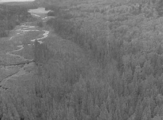
Wetlands3 are not a dominant feature of this conservation reserve and are mainly restricted to the many creeks (Map 3b). Many of the creeks contained shore fens and meadow marshes with the odd thicket swamp. Conifer swamps occur in a couple of black spruce and cedar dominated forest communities.
The conservation reserve is situated in the 2JD tertiary watershed of the Ottawa River major basin (OMNR 2002). Many of the creeks and small lakes in the site form headwaters to Mistinikon Lake and Montreal River.
5.0.2 Quality of representation
The quality of the representation or the current characteristics of the natural features found within the conservation reserve are as important as the overall representative features that are being protected. A number of factors are considered in evaluating a site and they include the following criteria: diversity, condition, ecological factors, special features and current land use activities.
-
Diversity
Diversity4 is a measure of the CR’s life and earth science heterogeneity. The evaluation is based on the number and range (variety) of the natural landscape features and landforms for earth science values and the relative richness and evenness of the site’s life science components. Based on Ontario Parks (2003) analysis of the conservation reserve within ecodistrict 3E-5, diversity is rated as low. There were 7 landform:vegetation (L:V) combinations of which only bedrock was the landform present. The dominant formations were dense deciduous forest (35.96% of the total area) and mixed deciduous forest (24.65%) on bedrock. These 2 vegetation groupings are equivalent to the different white birch forest communities from FRI. The quaternary geology cover was found to have ’shifted’ and so other landforms may not appear in the CR. Also, forest reserves were excluded from the analysis.
Based on Kristjansson’s (2004b) interpretation of the site and using SFUs, the diversity was originally rated as high (46 L:V’s) (Table 3). Using the 1% as the minimum area required to be represented in the site (anything less than 1% are usually accumulation of polygon slivers), the number of L:V’s was reduced to 19 or a rating of low. The CR is dominated by BW1 (31.57% of the total area) and MW2 (21.14%) on bedrock-drift complex (unit 2a). All other L:V combinations represent less than 10% each. Several of the L:V’s were added even though they account for less than 1% as they are whole polygons on a landform unit or rock (community) on bedrock (landform) is typical and represents unique habitat.
Wetlands add little to the diversity rating since it only accounts for 4.9% of the total area and it lacks variety. Development stages may add to the diversity rating. The 2 dominant SFUs are represented by immature, mature and old growth stages. The other SFUs are represented by at least immature communities with some including mature communities. Dispersion is another feature that could add to diversity since representation from each of the SFUs could be found across the CR. The cliffs on the west side add a unique feature to the site and support different plant life.
Evenness5 is the number of communities that control the vegetative nature of the site. If the site is equally represented by all its forest communities (SFUs) and FRI wetlands then evenness is considered even. For C1600, evenness is strongly skewed towards BW1, MW2 and SP1 (66.2% of the area total) and this has been re-iterated several times. As a result of this skewedness, diversity is greatly reduced in the CR.
-
Condition
Condition6 is the degree of past human and natural disturbance observed or recorded for the site. This Conservation Reserve, which has a low disturbance rating, is in almost pristine condition. Any disturbance was human related. An old camp was observed at the northeast corner of the unnamed lake in the southwest corner of the Conservation Reserve, with garbage strewn all around it (Nicholson 2003). Cottages are also situated on Bell Island and Mistinikon Lake. The other human disturbance was an abandoned fire tower at the southeast corner, just west of Mistinikon Lake. No roads or trails were observed.
-
Ecological factors
Ecological factors refer to the current design of the CR as noted by its size, shape, and ability to protect core ecosystems from adjacent land use activities. Whenever possible, a site’s boundaries should be created to include the greatest diversity of life and earth science features to provide the maximum ecological integrity. It should be ecologically self-contained, bound by natural features and include adequate area to protect the core ecosystems from intrusive adjacent land use influences (OMNR 1992).
Mistinikon Lake Uplands Conservation Reserve is bound by a mixture of biological and vectored borders as well as the West Montreal River Provincial Park on the east side. Using many of the vectors is unavoidable as no natural features are present. If the forest reserve at the southeast corner is dropped from the site, it is suggested the replacement area would be the indentation on the south side (Ecological Considerations Map, Appendix 8). This would create a more round site and reduce the appearance of ’bite marks’ in the CR. As well, to shorten the length of one vector, a creek and lake could be used on the west side. This would also provide more protection to the cliff and talus slopes in that immediate area. This site is fairly round so much of the core area remained intact. An important design aspect of this CR is the linkage to the provincial park and ultimately to C1602 at the north end of the provincial park. It increases representation in a protected area and thus diversity.
Currently we do not have minimum size standards for conservation reserves under different landscape conditions. However, a minimum size standard of 2000 ha has been established for natural environment parks by Ontario Parks (OMNR 1992). This minimum standard was considered necessary to protect representative landscapes as well as allow for low intensity recreational activities.
At 4330 hectares, it more than doubles the minimum standard. With its round shape and large size and many biological boundaries, the core areas are protected from any intrusive influences. The ’pristine’ condition also makes it attractive for non-motorized recreational activities.
-
Special features
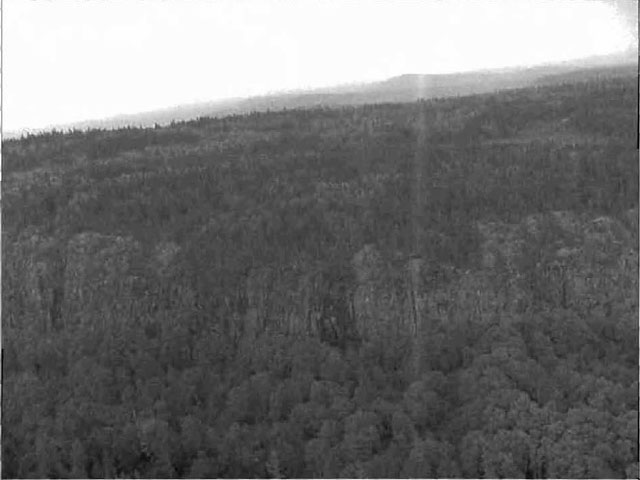
Special features include the ’pristine’ condition of the conservation reserve and the two cliffs on the west side. One is approximately 300 meters high and 2 kilometres long. Parts of this vertical rock face are vegetated with conifer trees. The other cliff is not as long or as high but it contains talus slopes on its lower half. Another special feature would be the rolling topography and the close resemblance it has to the Algoma Highlands in the Sault Ste. Marie area. The fire tower at the southeast corner would provide amazing views of the surrounding landscapes. The old growth yellow birch stands are the only areas that have a different age distribution. The rest of the site has a fairly even age distribution.
-
Current land use activities
Current activities include fishing, boating, canoeing, hiking, camping, hunting, trapping. Other potential activities, which are as yet unconfirmed, include ATV use, and snowmobiling.
1Conifer stands are defined as follows: pure conifer stands contain 100% of a conifer trees in the canopy; dominant conifer stands contain less than 10% cover of hardwoods in the main canopy and predominant conifer stands contain less than 20% cover of hardwoods in the main canopy. Similarly hardwood stands may contain no conifer in canopy (pure hardwood), less than 10% conifer (dominant hardwood) or less than 20% conifer cover (predominant hardwood) (modified after Taylor et al. 2000).
2Mixedwoods are defined as follows: hardwood mixedwoods are stands dominated by hardwoods with less than 30% cover of conifer in the main canopy; similarly conifer mixedwoods contain less than 30% hardwoods in the canopy. Mixedwoods contain approximately equal percentages of conifer and hardwood trees and true mixedwoods contain a 50:50 split between conifers and hardwoods (modified after Taylor et al. 2000).
3Wetlands were classified after Arnup et al. 1999 and Harris et al. 1996.
4Rating based on the amount of area currently under some form of known disturbance. High is >20% of the area, medium 10 to 20%, low <10% and pristine <1%.
5Diversity rating, developed by John Thompson & Jake Noordhof (2003), is based on the size of the conservation reserve versus the number of landforms:vegetation (SFU/HU) combinations. For CR’s <500 ha, high diversity is >25 L:V combinations, medium for >15 L:V, and low for <15 L:V. For areas 500-2000 ha, high is >30, medium >20 and low <20. For areas >2000 ha, high >35, medium >25 and low <25 L:V combinations.
6Evenness of the site defined as strongly skewed (top 3 communities capture >=60% of the site in area), moderately skewed (30-59%) or slightly skewed to even (<30%).
5.0.3 Summary
Mistinikon Lake Uplands Conservation Reserve is a locally significant area represented by dense deciduous forest (35.96% of the total area) and mixed deciduous forest (24.65%) on bedrock. A total of 19 landform:vegetation combinations were determined giving a low diversity rating. The sensitive areas of the site include Lake Mistinikon and the resident sport fish. The current fishing pressure on Mistinikon is unknown although it appears to be a high use area. This site will have a low activity attraction capability. The sites location within a forested landscape and primarily off road access limits the sites current geographical significance and its backcountry travel qualities.
5.0.4 Natural heritage representative features
This site is characterized by stands of spruce, poplar and birch on fresh sites on moderately sloping terrain. Red and White pine trees occur on sand ridges and American elm and white cedar are found only in protected areas. The landform is characterized by gently rolling plains with thinly covered rock knobs, sandy outwash and silty depressions. The landscape is broken throughout by glacial features such as moraines, eskers with Canadian Shield exposure. The forest climate type is mid-humid, mid-boreal (Poser 1992; Noble 1983). Flat to gently rolling, glacial clay and sand plain with locally extensive peatlands and wetlands characterize the ecoregion. The dominant formations were dense deciduous forest (35.96% of the total area) and mixed deciduous forest (24.65%) on bedrock. These 2 vegetation groupings are equivalent to the different white birch forest communities from FRI. The CR is dominated by 2 SFUs (BW1 and MW2) and basically 2 landform units (2ac and 3e). There are 8 other SFUs which only account for <10% each of the total area.
5.0.5 Forest Resource Inventory (FRI) data
- Dominant species, wetlands, and depleted areas
- See Forest Communities Map (Map 2a, Appendix 8)
5.1 Social/economic interest in area
5.1.1 Linkage to local communities
The Mistinikon Lake Uplands Conservation Reserve is a 4,330 ha parcel of Crown land that is situated approximately 50 km southwest from the Town of Kirkland Lake and 10 km west of the Town of Matachewan. This site is found within Bannockburn, Powell, Yarrow and Doon Townships in the District of Kirkland Lake (Locator Map, Appendix 7).
Current uses include fishing, boating, canoeing, hiking, camping, hunting, trapping. Potential recreational activities could include rock climbing and possible non-consumptive uses such as bird watching, photography or nature study.
Table 3: Vegetation types
| BW1 | LC1 | MW1 | MW2 | PJ1 | PJ2 | PO1 | SB1 | SF1 | SP1 | Tread Muskeg | Open Muskeg | Brush/Alder | Rock | Total | Modified Total | |
|---|---|---|---|---|---|---|---|---|---|---|---|---|---|---|---|---|
| 9 | X | X | X | X | X | X | X | X | X* | X | 10 | 1* | ||||
| 3,2a | X* | X | X* | X* | X | X* | X* | X | X | X | X* | X | 12 | 6* | ||
| 3e,2a | X | X | X | X | 4 | 0* | ||||||||||
| 2 | * | |||||||||||||||
| 2a | X* | X | X* | X* | X* | X* | X* | X* | X | X* | X | X* | X | 13 | 9* | |
| 1 | X | X** | X | Xx** | X | X | Xx** | 7 | 3* | |||||||
| Total | 5 | 1 | 3 | 5 | 3 | 1 | 4 | 5 | 3 | 4 | 3 | 4 | 3 | 2 | 46 | * |
| Modified Total* | 2* | 0* | 1* | 3* | 2* | 1* | 1* | 3* | 1* | 1* | 0* | 2* | 1* | 1* | * | 19* |
*Those areas that represent more than 1% of the total area.
**Those areas that represent less than 1% of the total area but were whole polygons or unique habitats.
5.1.2 Heritage estate contributions
The Mistinikon Lake Uplands Conservation Reserve contributes to the province’s parks and protected areas system through its regulation, representation and the long-term management of natural heritage values. By allocating these lands to the parks and protected areas system, the province has ensured a certain level of permanence by distinguishing the site and its values from the broader general use or more extensively managed landscape. In addition, its natural features are, and will be available for present and future generations to enjoy and explore.
5.1.3 Aboriginal groups
The Mistinikon Lake Uplands Conservation Reserve falls within the Matachewan and Temagami First Nations and the Teme-Augama Anishnabai Aboriginal Community’s identified notification area.
Temagami First Nations and Teme-Augama Anishnabai Aboriginal Community requested that draft copies of this SCI were simply mailed to them. This was done and they were given more than 30 days to provide comments. To date no comments have been received.
MNR staff met with Matachewan First Nations to present this draft SCI and to request their input to this document. A second meeting was scheduled where members of council and the community had the opportunity to voice opinions and influence wording and content of this SCI.
5.1.4 Mining interests
There are two current mining leases (L1207502 & L 1207504) within the conservation reserve (shown as a Forest Reserve). Mining and surface rights have been withdrawn from staking within the conservation reserve’s boundaries under the Mining Act (RSO 1990 Chapter M.14).
5.1.5 Forest and fire management history
This site has been harvested within certain small sections in the last 30 years. The majority of the stands are 65 to 75 years of age suggesting fire swept through the area in the 1930’s but, according to the fire disturbance map (C1600 Fire Disturbance Map, Appendix 8), only the northwest corner burned in 1935. Also, several areas which fall within the area affected by the 1935 fire are only 30-59 years old. This suggests some sort of disturbance occurred in these area within 10 to 39 years after the fire. There is no record of further fire activity within this time frame and this does not allow enough re-growth time for this disturbance to have been harvesting. It is therefore believed by district foresters that these younger stands were affected by spruce budworm in the early 1980’s.
5.2 Natural heritage stewardship
Analysis of the Life Science targets based on landform:vegetation combinations have shown that the conservation reserve contains 19 landform: vegetation combinations. A total of 7 separate forest communities were identified using recent forest community classifications and not including wetlands (Map 2a, Appendix 8). The dominant combinations were dense deciduous forest and mixed deciduous forest on bedrock. Although there are 7 different forest communities and wetlands present in the site, three communities (Po mixwood, Bw conifer dominant, and Sb mixwood) account for approximately 40% of the area. The majority of the communities are below 100 hectares in size. Most of the areas fall into one of two age groups; 30 to 59 or 60 to 89. Black spruce, old jack pine and aspen complement the white birch stands and old growth yellow birch is also present. These yellow birch stands, based on Bridge et al. definitions (2000), were classified as old growth (Map 5, Appendix 8). The only other old growth occurs in a Sb dominant conifer stand on the mid-north boundary.
5.3 Fish and wildlife
Mistinikon Lake is identified as a warm-water fish community. Fish species include Brook Trout, Northern Pike, Smallmouth Bass, Walleye, Yellow Perch, Whitefish, Herring Sucker and Burbot. Angling pressure in the summer is mostly restricted to Mistinikon (due to access), although winter may see an increase in fisherpersons as snowmobile access should be available. Loonwing Lake has been stocked with Splake. Currently, no fisheries information is available for the other isolated lakes and creeks within the site. Further assessment and management will continue under the Kirkland Lake District, Elk Lake/Matheson Area Supervisor.
This area is also used for hunting and trapping. There is one BMA and three traplines within the reserve area. The forest communities are typical of early winter habitat; mature to over mature mixedwood stands. Late wintering habitat occurs in several areas and these areas are generally dense conifer forest communities.
5.4 Cultural heritage stewardship
To date, little is known regarding the cultural values of the Conservation Reserve as a detailed assessment of cultural resources has not been carried out. However, the West Montreal Canoe Route runs through the Conservation Reserve and can be considered a cultural value.
5.5 Land use/existing development
This conservation reserve is situated entirely on Crown land and is unencumbered by any patented land, land use permits, or leases. It does however, overlap two mining claims, (1207502 & 1207504) which have been designated as forest reserves.
A forest reserve is a land use designation (LUS 7.2.3) applied to areas that were initially identified for inclusion in the conservation reserve (CR) but where subsequent detailed examination determined that there were existing mining leases or claims.
Mining and surface rights have been withdrawn from staking within the conservation reserve boundaries under the Mining Act (RSO 1990 Chapter M.14). Therefore, no new claims can be staked within the CR boundary. The intent is that the forest reserve (FR) will be added to the CR if the claim or lease is retired through normal process.
Policies for FR’s are similar to the policies for new CR’s, except that mining, and related access, is allowed in a forest reserve.
5.6 Commercial land use
Present commercial use activities overlapping the site include one Bear Management Area (Kl-29-034) and four traplines (KL032, KL033, KL036 & KL040) (Map 3A, Appendix 8).
5.7 Tourism/recreation use/opportunities
Some of the features within the site associated with possible recreational use include water bodies, water routes, large mammals, beaches, stacks and cliffs, Colluvial landforms and aquatic flora and fauna. Existing recreational uses in this site and immediately surrounding the site include trapping, hunting, hiking, boating, canoeing, camping, swimming and fishing. There is also potential for activities such as ATV and snowmobile use, bird watching and nature study.
For a more detailed report and summary of the recreational use and potential, refer to the Recreational Inventory Checksheet (Appendix 3).
5.8 Client services
Currently, visitor services are limited to responding to inquiries about access, natural heritage features and boundaries. No formal information or interpretive facilities currently exist within the conservation reserve. Other customer services available through the Kirkland Lake District office include providing clients with maps, fact sheets, and other information gathered on the area, such as the earth/life sciences and recreational inventory work.
6.0 Management guidelines
6.1 Management planning strategies
The land use intent outlined in the OLL LUS (MNR, 1999) provides context and direction to land use, resource management, and operational planning activities on Crown Land in the planning area and within OLL site boundaries. Commitments identified in the OLL LUS and current legislation (Policy 3.03.05 PLA) forms the basis for land use within the Mistinikon Lake Uplands Conservation Reserve. Management strategies for these uses must consider the short and long-term objectives for the conservation reserve. For up to date information on permitted uses refer to the Crown Land Use Atlas (MNR, 2002) (Appendix 6).
Proposed new uses and development will be reviewed on a case-by-case basis. A Test of Compatibility, (Procedural Guideline B-Land Uses (Appendix 4)) must be completed before proposals can be accepted. In all cases, ensuring that the natural values of the conservation reserve are not negatively affected by current and future activities will be the priority. Therefore any application for new specific uses will be carefully studied and reviewed.
6.1.1 Forest reserves
Under the OLL LUS, mining and related access will be allowed in a forest reserve. For those activities that could negatively influence the natural heritage values within the FR and/or the CR, the district will work with the proponent to identify and mitigate potential mining or natural heritage concerns. Mining will not occur in any portion of the regulated conservation reserve boundary.
6.2 “State of the Resource” management strategies
The development of this SCI and the long term management and protection of the Mistinikon Lake Uplands Conservation Reserve will be under the direction of the MNR’s Kirkland Lake District, Elk Lake - Matheson Area Supervisor. The following management strategies have been created to achieve the goal and objectives stated earlier in this management document.
6.2.1 Natural heritage stewardship
The management intent for the Mistinikon Lake Uplands Conservation Reserve is to allow for natural ecosystems, processes and features to operate undisturbed with minimal human interference while providing educational, research and recreational activities. Forest ecosystem renewal will only be entertained via a separate vegetation management plan. As part of any future vegetation management plan the site and its Site EcoDistrict will be re-evaluated with respect to their known landform/vegetation features to determine if the past harvested areas could contribute additional landform/vegetation values to the Site EcoDistrict.
In addition, the vegetation management plan will need to determine but not be limited to:
- the restoration ecology objectives (e.g. representation) for the area in context with the Site EcoDistrict;
- consider current provincial strategies (e.g. white pine);
- consider larger long-term conservation reserve (e.g. recreational objectives) and possibly landscape objectives (e.g. contributions to landscape wildlife objectives).
Fire is recognized as an essential process fundamental to the ecological integrity of conservation reserves. In accordance with existing Conservation Reserve Policy and the Forest Fire Management Strategy for Ontario, forest fire protection will be carried out as on surrounding lands.
Whenever feasible the MNR fire program will endeavor to use “light hand on the land” techniques, which do not unduly disturb the landscape, in this conservation reserve. Examples of light hand on the land techniques may include limiting the use of heavy equipment, utilizing high water bomber drops, non use of foaming agents, or limiting the number of trees felled during the fire response efforts.
Opportunities for prescribed burning to achieve/emulate ecological or resource management objectives may be considered. These management objectives will be developed with public consultation prior to any prescribed burning, and reflected in the document that provides management direction for this conservation reserve. Plans for any prescribed burning will be developed in accordance with the MNR Prescribed Burn Planning Manual, and the Class Environmental Assessment for Provincial Parks and Conservation Reserves (approval pending).
Defining compatible uses, enforcing regulations and monitoring and mitigating issues will protect all earth and life science features. Industrial activities such as commercial timber harvest and new hydro generation will not be permitted within the conservation reserve. Permits for fuel-wood will not be issued. New energy transmission, communication and transportation corridors or construction of facilities are not permitted within the boundaries of the conservation reserve. Such structures negatively impact the quality of the representative features that require protection. Alternatives should be reviewed via larger landscape planning processes. New roads for resource extraction will not be permitted. Other activities that do not pass a Test of Compatibility will be prohibited (MNR Policy 3.03.05, 1997).
The introduction of exotic and/or invasive species will not be permitted. Programs may be developed to control forest insects and diseases where they threaten significant heritage, aesthetic, or economic values. Where control is desirable, it will be directed as narrowly as possible to the specific insect or disease. Biological or non-intrusive solutions should be applied whenever possible.
The collection/removal of vegetation and parts thereof will not be permitted; however, subject to a Test of Compatibility, the Area Supervisor may authorize such activities for purposes of rehabilitating degraded sites within the reserve, collecting seeds for maintaining genetic stock and/or for inventory or research purposes.
MNR will provide leadership and direction for maintaining the integrity of this site as a heritage estate. To ensure MNR protection objectives are fully met within the conservation reserve, activities on the surrounding landscape must consider the site’s objectives and heritage values. Research, education and interpretation will be encouraged to provide a better understanding of the management and protection of the natural heritage values and will be fostered through local and regional natural heritage programs, initiatives and partnerships.
The conservation reserve will be managed by allowing natural ecosystems, processes, and features to function normally, with minimal human interference.
6.2.2 Fish and wildlife
Fish and wildlife resources will continue to be managed in accordance with specific policies and regulations defined by the Ontario Ministry of Natural Resources under the Fish and Wildlife Conservation Act and the Kirkland Lake District, Elk Lake - Matheson Area Supervisor. The final decision to allow stocking in the Mistinikon Lake Uplands Conservation Reserve lies with the approval of the Kirkland Lake District Manager.
6.2.3 Cultural heritage
When possible, the Ministry of Natural Resources will continue to work with the Ontario Ministry of Culture, Tourism and Recreation in identifying archaeological sites to be protected. To more fully manage and protect sites, the development of field surveys would be required. However, at this time additional field surveys within the conservation reserve are not recommended.
Development, research and education proposals may be considered in accordance with the Test of Compatibility and Conserving a Future for our Past: Archaeology, Land Use Planning & Development in Ontario, Section 3 (OMC, 1997).
6.2.4 Land use and development
The sale of lands within the conservation reserve is not permitted as per the OLL LUS (MNR, 1999). Existing authorized trails can continue to be used and maintained, unless there are significant demonstrated conflicts. New trails will only be allowed if a Test of Compatibility is passed. Any new trail development will require an amendment to the SCI. The cutting of trees for non-commercial purposes (e.g. fuelwood) is not permitted except as required for approved development activity (e.g. trail, viewing site, etc.). New roads for resource extraction may be permitted under the Class Environmental Assessment Act (Ontario Parks, 2004).
There are no other forms of tenure in the conservation reserve other than legal agreements with registered trappers, and bear management area operators. The construction of new trap cabins will not be permitted; however, existing cabins will be allowed to continue (MNR, 1999).
Traditional uses within the conservation reserve will continue to be permitted; however, the goal will be to resolve conflicts regarding incompatibility between uses and to ensure that identified values are adequately protected.
6.2.5 Commercial use
All existing commercial resource use activities (i.e. trapping, baitfish harvesting, fishing and wild rice harvesting) are permitted to continue and new uses (with the exception of commercial bear hunting) may be introduced, subject to protection of the conservation reserve’s natural heritage values (i.e. test of compatibility).
Commercial bear hunting (within BMA) operations may continue and the transfer of existing licenses is allowed, providing the activity has been licensed/permitted since January 01, 1992. Licenses to provide Bear Hunting Services will not be issued in areas where issuance has not occurred since January 01, 1992.
Existing commercial fur harvesting operations are permitted to continue. New operations may be considered subject to a Test of Compatibility.
6.2.6 Aboriginal interests
The Mistinikon Lake Uplands Conservation Reserve is within the Matachewan First Nation’s area of interest, therefore invitations for comment and participation have been extended. Aboriginal and treaty rights will continue to be respected throughout the management of this conservation reserve. The members of the Matachewan First Nation are governed by the James Bay Treaty #9. The land encompassed by this CR is governed by the Robinson Treaty. For further details of these treaties please see Appendix 11 (Treaty #9) and Appendix 12 (Robinson Treaty).
Any future proposal(s) and or decision(s) that have potential impact(s) on individual aboriginal values and or communities will involve additional consultation with the affected aboriginal groups. Neither the regulation of this conservation reserve nor the approval of this SCI will have bearing on the Matachewan traditional land uses.
6.2.7 Tourism/recreation
Most recreational activities that have traditionally been enjoyed in the area can continue provided they pose no threat to the natural ecosystems and features protected by the conservation reserve. These permitted activities include walking, hiking, wildlife viewing, fishing, hunting, snow shoeing, and cross-country skiing.
Snowmobiles and All Terrain Vehicles (ATVs) are permitted on existing trails and forest access roads within the Conservation Reserve. Under the OLL LUS (MNR, 1999}, all mechanized travel is restricted to existing trails. Off-trail vehicle use is permitted for the retrieval of game only. The use of existing trails, within the Mistinikon Lake Uplands Conservation Reserve, does not degrade the values of this site.
Existing trails for hiking, snowmobiling, ATV use, cycling, horseback riding and cross-country skiing can continue. To ensure the quality of the representation is maintained, all trails and old forest access roads (Road Access Map, Appendix 8) within the site should be identified via new technologies (i.e. GPS) to ensure a record of these features exists. The completion of this data collection is dependant on time and fiscal constraints. New trails can be considered through a Test of Compatibility.
Finally, conflict resolution between recreational uses will be a priority. This will be achieved by adhering to the objectives of this SCI with input from relevant user groups. The level of safety and compatibility between activities will determine permitted uses (i.e. Test of Compatibility).
6.2.8 Client services
Clients indicating their interest in the management, planning and future use of this conservation reserve will be put on a mailing list and notified of any future planning concerning the site.
Present client services such as supplying maps, fact sheets and other information will also continue. Information may be delivered from different sources; however, MNR will be the lead agency for responding to inquiries regarding access, permitted and restricted activities, values and recreation opportunities. A management agreement may be pursued with an appropriate partner to share responsibilities for information services and the delivery of other aspects of this SCI in the future.
6.3 Specific feature/area/zone management strategies
There are no specific management strategies for the maintenance/protection/enhancement of selected resources within the conservation reserve. Development of such strategies will require an amendment to the SCI.
6.4 Promote inventory, monitoring and assessment reporting (IMAR), and research
Scientific research by qualified individuals, which contributes to the knowledge of natural and cultural history, and to environmental and recreational management, will be encouraged.
Research related to the study of natural processes will be encouraged provided it does not harm the values of the reserve. The Elk Lake - Matheson Area Supervisor or District Manager may approve the removal of any natural or cultural specimen by qualified researchers. All such materials removed remain the property of the Ministry of Natural Resources. All research programs will require the approval of the Ministry of Natural Resources and will be subject to Ministry policy and other legislation.
New research developments such as campsites, privies, trails or developed access points or activities will not be considered until a Test of Compatibility is conducted and the proposal is approved by the Elk Lake - Matheson Area Supervisor or District Manager. The Test of Compatibility or Environmental Screening Process could include a review of the demand for structures or activities and may require more detailed life or earth science or cultural information and possibly more detailed management plan.
Approved research activities and facilities will be compatible with the site’s protection objective. Permanent plots or observation stations may be established to which researchers can return over time. Any site that is disturbed will be rehabilitated as closely as possible to its orjginal state.
6.5 Implementation, and plan review strategies
Mistinikon Lake Uplands Conservation Reserve SCI will be reviewed on an ongoing basis and as required.
Implementation of the SCI and management of the reserve are the responsibility of the Elk Lake - Matheson Area Supervisor. Partnerships may be pursued to address management needs.
If changes in management direction are needed at any time, the significance of the changes will be evaluated. Minor changes that do not alter the overall protection objectives may be considered and approved by the District Manager without further public consultation and the plan will be amended accordingly. In assessing major changes, the need for a more detailed Resource Management Plan will first be considered. Where a Resource Management Plan is not considered necessary or feasible, a major amendment to this SCI may be considered with public consultation. The Regional Director must approve major amendments.
6.6 Marketing strategies
Mistinikon Lake Uplands Conservation Reserve will be marketed as a representative natural area having Earth and Life Science values, as well as certain recreational values. Marketing efforts to increase use are not a priority and will be kept to a minimum.
6.7 Boundary identification
There is no stated policy to mark the boundaries of a Conservation Reserve. Local management discretion can be used to determine where boundary marking may be appropriate. In order for restrictions to be enforceable, signs must be placed in accordance with the Trespass to Property Act or subsection 28 (1) of the Public Lands Act to advise against any recreational activities.
7.0 References
Arnup, R., G.D. Racey and R.E. Whaley. 1999. Training manual for photo interpretation of ecosites in northwestern Ontario. NWST Technical Manual TM-003.127p.
Bridge, Simon; Watt, Robert; Lucking, Greg; and Brian Naylor. 2000. Landscape analysis for forest management planning in boreal northeastern Ontario. OMNR, Northeast Science & Technology. 36p.
Grins, W.J. and P.W.C. Uhlig. 2000. Ecoregions of Ontario: Modifications to Angust Hill’s Site Regions and Site Districts-Revisions and Rationale.
Harris, A.G., S.C. McMurray, P.W.C. Uhlig, ..I.K. Jeglum, R.F. Foster and G.D. Racey. 1996. Field guide to the wetland ecosystem classification for northwestern Ontario. Ont. Min. Natur. Resour., Northwest Sci. & Technol. Thunder Bay, Ont. Field Guide FG-01. 74 pp. + append.
Hills, G.A. 1959a. A Ready Reference to the Description of the Land of Ontario and its Productivity.
Keddy, C. 1997. Natural Heritage Gap Analysis for Site District 3E-5: GIS Analysis. by Geomatics International Inc.
Kristjansson, R. 2004a. Personal Conversation. Kristjansson, R. 2004b. Earth Science Planning Summary. Nicholson, J. 2003. C1600 Aerial Reconnaissance Notes.
Noble, T.W. 1983. Central Boreal Forest Region (3E). Life Science Report.Northeastern Region. Internal report.
Ontario Ministry of Culture (OMC). 1997. Conserving A Future for Our Past: Archaeology, Land Use Planning and Development in Ontario. Toronto: Cultural Programs Branch, Archaeology & Heritage Planning Unit.
Ontario Ministry of Natural Resources (MNR). 1997. Ontario Watershed Mapping.
Ontario Ministry of Natural Resources (MNR). 1999 (March). Proposed Ontario Living Legacy Land Use Strategy.
Ontario Ministry of Natural Resources (MNR). 1999. Ontario Living Legacy Land Use Strategy.
Ontario Ministry of Natural Resources (MNR). 2002. MNR Districts and Major Basins of Ontario.
Ontario Ministry of Natural Resources (MNR). 2004. Crown Land Use Policy Atlas.
Ontario Parks. 1992. Provincial Parks: Planning and Management Policies - Update.
Ontario Parks. 2004. A Class Environmental Assessment for Provincial Parks and Conservation Reserves.
Ontario Parks. 2003. Landform/Vegetation Representation Summary for site C1600 in Ecodistrict 3E-5. (May 2003). Internal Report
Poser, S. 1992. Report of the status of provincial parks in the site region and districts of Ontario. Ministry of Natural Resources Report.
Roed, M.A. and D.R. Hallett. 1979. Northern Ontario Engineering Geology Terrain Study. Data Base Map. Elk Lake. Ontario Geological Survey, Map 5020, Scale 1:100 000.
Rowe, J.S. 1972. Forest Regions of Canada. Department of Fisheries and the Environment-Canadian Forestry Service Publication No. 1300. 172p.
Telford, J. 2004. Recreation Inventory Report. Mistinikon Lake Uplands Conservation Reserve.
Thompson, John E. & Jake Noordhof. 2003. Edit Model for N.E. Region Life Science Checksheets. Internal Report.
Appendix 1: Public consultation summary
| Date received | Client | Comment | Action taken | Date responded |
|---|---|---|---|---|
| August 30, 2000 | 143 | Client not pleased that SCI ad appeared in newspaper before mail out to organizations. Also not pleased that District Planner would not be available during consultation period. | Added client to mailing list for all 26 sites. Reassured client that maps were included in the individual and organization mailouts. Reassured client that any concerns could be addressed by OLL staff. | August 30, 2000 |
| September 5, 2000 | 82 | Received fax requesting info on boundaries and OLL | Phoned to discuss areas indicated Sent info by mail |
September 5 September 6 |
| July 31, 2003 | 548 | Contacted First Nations to invite member to accompany MNR staff on site inventory | ||
| November 19, 2004 | 146 | Visited office, had received notification of Draft SCI Review, was interested in reading the draft | Showed him to reading room, where office copies of draft SCIs is are kept Mailed copy of SCI to his home address |
November 19 November 24 |
| December 17, 2004 | 146 | Client called looking to ensure that hunting and trapping would be permitted to continue in the conservation reserve. | Planning Staff reassured client that established BMAs and traplines would not be affected and that recreational hunting and fishing could continue. | December 17, 2004 |
| December 20, 2004 | 146 | Client wished to indicate the presence of a snowmachine/ATV trail right to the head of the lakes which the client believes falls within the CR. Also wished to confirm that hunting and fishing would continue to be permitted on any new trails established within the CR | Planning staff sent a letter thanking the client for their information regarding existing trails within the site. This letter also reassured the client that hunting and fishing could continue and that any new trails | December 24, 2004 |
| December 23, 2004 | 143 | Client visited office and read Draft SCIs. Expressed several concerns and questions to planning staff. | Planning staff addressed as many of these comments as possible in person. A letter was sent the following day containing answer to the remaining questions. This letter is in the C1600 file. | December 23, 2004 |
Appendix 2: Public consultation ad
Review of draft statements of conservation interest
C1615 Maisonville Bernhardt Muskeg Maple Moraine
C1611 Shallow River Poplar Outwash C1628 Trollope Lake Burnt Hill Poplar Spruce
C1600 Mistinikon Lake Uplands
C1634 Dunmore Township Balsam Fir Outwash Conservation Reserves
The Ministry of Natural Resources (MNR) invites you to review the draft statements of conservation interest (SCI) for the Maisonville Bernhardt Muskeg Maple Moraine, Shallow River Poplar Outwash, Trollope Lake Burnt Hill Poplar Spruce, Mistinikon Lake Uplands and Dunmore Township Balsam Fir Outwash Conservation Reserves. Copies of these draft documents will be available for review at the Kirkland Lake District MNR office until December 20, 2004.
The Maisonville Bernhardt Muskeg Maple Moraine Conservation Reserve is situated 10 kilometers northwest of the Town of Kirkland Lake. This conservation reserve is located within the township of Bernhardt and is 128 hectares in size. The Shallow River Poplar Outwash Conservation Reserve is situated 45 kilometers northwest of the Town of Kirkland Lake. This conservation reserve is located within the townships of Beatty and is 396 hectares in size. The Trollope Lake Burnt Hill Poplar Spruce Conservation Reserve can be found 50 kilometers east of the Town of Matheson. This conservation reserve is located within the townships of Frecheville and Stoughton and is 2108 hectares in size. The Dunmore Township Balsam Fir Outwash Conservation Reserve is found 10 kilometers northeast of the Town of Matheson. This conservation reserve is located within Beatty Township and is 396 hectares in size. The Mistinikon Lake Uplands Conservation Reserve is located 10 kilometers west of the town of Matachewan in Doon, Powell, Yarrow and Bannockburn townships. This conservation reserve is 4,330 hectares in size.
The statements of conservation interest identify area values and provide direction on resource management activity and appropriate land uses. As conservation reserves, commercial activities such as forest harvesting, mining and hydroelectric power development are prohibited from occurring within the protected area.
The Ministry of Natural Resources (MNR) is collecting comments and information regarding the draft statements of conservation interest under the authority of the Public Lands Act to assist in making decisions and determining future public consultation needs. Comments and opinions will be kept on file for use during the plan’s operating period and may be included in the study documentation, which is made available for public review.
Under the Freedom of Information and Protection of Privacy Act (1987) personal information will remain confidential unless prior consent is obtained. However, this information may be used by the Ministry of Natural Resources to seek public input on the other resource management surveys and projects. For further information on this Act, please contact Shaun Walker at
If you would like additional information or would like to supply background information or viewpoints to be considered by the planning team, please contact:
Jessy Malone or Jody Bissett
Land Use Planners
Ministry of Natural Resources
Kirkland Lake District
P.O. Box 910, 10 Government Road East
Kirkland Lake, ON
P2N 3K4
Comments will be accepted until December 20, 2004
Renseignement en francais:
Recreation inventory report
Mistinikon Lake Uplands Conservation Reserve C1600
January 12, 2004
Prepared For: OMNR, Northeast Region
Jennifer Telford
Kirkland Lake District, OMNR
Introduction
The Mistinikon Lake Uplands Conservation Reserve is located in northeastern Ontario approximately 50 kilometres from the Town of Kirkland Lake.
Conservation Reserves identified in Ontario’s Living Legacy Land Use Strategy (LUS) were given interim protection and the intention is to have all of the sites formally regulated under the Public Lands Act by 2004. The process to regulate the Mistinikon Lake Uplands Conservation Reserve was completed in May 2002.
In addition to the regulation process, a number of inventories, including a Recreation Inventory Report, are being conducted in the Living Legacy sites. Recreation inventories are particularly important to the OLL planning process, as one of the major objectives of the LUS is to ensure that a broad range of natural resource-based recreation opportunities are provided for. As a result the Ontario’s Living Legacy Guidelines for Recreation Assessment were developed. Under the guidelines all inventories are guided by four basic objectives:
- Identify landforms and features, which are or may be used for recreation.
- Identify the range of settings that the protected area is able to provide.
- Identify all known existing recreational activities.
- Identify all means by which the protected area can be accessed.
The Mistinikon Lake Uplands Conservation Reserve Inventory was influenced by the four basic objectives but it also attempts to evaluate the impact of humans in the site.
Figure 1 Map - Mistinikon Lake Uplands Conservation Reserve
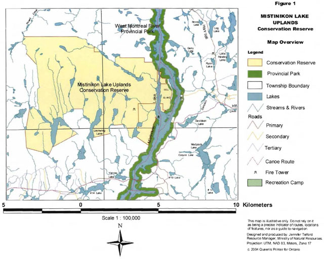
Enlarge Figure 1 Map - Mistinikon Lake Uplands Conservation Reserve
3.0 Description of the study area
3.1 General setting
The Mistinikon Lake Uplands Conservation Reserve is situated in the Townships of Bannockburn, Powell, Doon, and Yarrow. The conservation reserve covers an area of approximately 5071 hectares. The nearest community is the Town of Matachewan which is located approximately 10 kilometres from the conservation reserve.
A few other protected areas are within close proximity to the site. These areas are all Ontario Living Legacy sites. The Dunmore Township Balsam Fir Outwash Deposit Conservation Reserve has already been regulated and the Whitefish River Sandy Till and the Whitefish and East Whitefish Lakes Sandy Till Uplands Conservations Reserves will be regulated in the spring of 2004. The West Montreal River Provincial Park encompasses Mistinikon Lake and was regulated in 2001.
3.2 Cultural values
Little is known about the cultural values of the conservation reserve. The Matachewan First Nation has an interest in the land because it is in their traditional land use area. The West Montreal Canoe Route runs through the conservation reserve and can be considered a cultural value.
3.3 Life science values
The life science evaluation for this site has not yet been completed. Tree species observed in the site include black spruce, jack pine, poplar and white birch. The site also contains old growth yellow birch and scattered white pine.
3.4 Earth science values
The earth science values of this conservation reserve have not been well documented. Aerial inventories have been conducted and, at the time of writing, the earth science check sheet for the Mistinikon Lake Uplands Conservation Reserve was being prepared. What is known is the site is dominated by bare bedrock and strongly broken deep and shallow sandy till. There are cliff communities, steep hills and kettle lakes in the conservation reserve.
4.0 Methodology
Primary and secondary resources were used to gather information for this recreation inventory report. Primary research consisted of field site visits and discussions with district staff. Secondary research was done prior to field visits.
Table 1: Summary of information sources [reproduced as a list]
Primary research
- Two ground visits (August 13, 15, 2003)
- Aerial visit (September 24, 2003)
- Contact with District staff
Secondary research
- Internal OLL documents
- OBM and OLL Maps
- Air Photos
The two ground visits were each a day in length and covered as much of the site as possible. The ground visits were made with a four-wheel drive truck and a boat. Most of the travel done within the Conservation Reserve was by boat and on foot. Land routes and road access were documented with a GPS unit and digital photographs were taken of interesting features. Water routes around Bell Island were explored as well as the hiking trail up to a fire tower situated within the site.
Information gathered from the site visits was then used to complete the recreation checklist (Appendix A). The checklist was completed in accordance with the Ontario’s Living Legacy Guidelines for Recreation Resource Assessment, Version 3 - May, 2002 and data was entered into the Microsoft Access form provided. A map of the site was created using the site access information gathered from the GPS unit.
5.0 Recreation features
Recreation features are biophysical or cultural attributes that may be able to support recreational activity. A total of six features were recorded and ranked according to their recreational value and importance in the Recreation Inventory Checklist (Appendix A). Listed features have a corresponding code and are classified under a specific category according to the Ontario’s Living Legacy Guidelines for Recreation Resource Assessment, Version 3- May, 2002. The following sections provide more detail on each of the features.
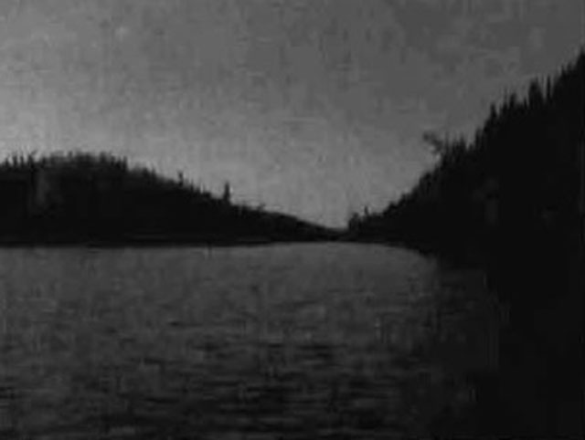
5.1 Waterbodies (M00) - waterbodies
The Mistinikon Lake Uplands Conservation Reserve contains a number of water bodies within its boundaries. The most prominent water body is Mistinikon Lake. The lake is actually part of the West Montreal River. Only the west side of the lake is part of this site. The West Montreal Provincial Park encompasses the rest of the lake. Loonwing Lake, in the southwestern part of the site is a good sized lake and there is another good sized unnamed lake in the southwest of the site as well. There are small and medium sized lakes scattered throughout the rest of the conservation reserve. Many of these lakes are kettle lakes.
Access to Mistinikon Lake is available. There are a few roads that lead to the lake. There is a public boat launch across from Bell Island. There is plenty of parking available and seems to be how most people access the lake. There is access to Loonwing Lake via ATV/snowmobile trail. The lake is fished in summer and winter and there are a few cabins in the area. At the time of the aerial survey it was noted that a cabin had been on the lake but it had burned down.
5.2 Sport fish (A01) - Aquatic flora/fauna
Mistinikon Lake contains northern pike, walleye, smallmouth bass, yellow perch, whitefish, herring, sucker and burbot. There have not been any recent creel surveys done on Mistinikon Lake and therefore the current fishing pressure on the lake is not known. Loonwing Lake has recently been stocked with splake. The state of the fisheries of the other lakes within the conservation reserve is not known at this time. A number of people were observed fishing on Mistinikon Lake during fields visits and it is a favourite fishing spot for many people in the Kirkland Lake District.
5.3 Large land mammals (W03) - wildlife
Black Bear and Moose can both be found within the site. The site contains one bear management area and district staff are aware of moose and bear hunting in the area.
5.4 Water routes (T05) - trails or routes
Mistinikon Lake is part of the West Montreal canoe route. The West Montreal Canoe Route travels through the entire length of Mistinikon Lake. The route, which begins west of Gowganda and ends in Matachewan, is 64 kilometres long and classified as an intermediate paddle. (Canadian Canoe Routes)
5.5 Shore features-general (B00) - shore features
The site contains a few islands on Mistinikon Lake. The most notable of these being Bell Island which is a large island in the middle of the lake. The west side of Bell Island is part of the conservation reserve. A few smaller islands on the west side of the lake are within the conservation reserve as well. The site also contains numerous creeks, streams and lakes with their associated shore features.
5.6 Stacks and cliffs (Q19) - landform, broad
The site contains numerous cliffs and esker walls. The western shore of Mistinikon Lake within the conservation reserve has numerous cliff faces and rock walls. Cliffs and esker walls can also be found in the south of the site next to Loonwing Lake, on the fire tower hill, and in the north east of the conservation reserve. The cliffs along the lake add a significant scenic value to the Mistinikon Lake Uplands Conservation Reserve.
5.7 Colluvial (J01) - landform, surface material
A talus slope was observed on the western shore of Mistinikon Lake during a field visit. Due to the number of other cliffs and esker walls within the site it is possible that more than one talus slope or area of landslide debris exists in the conservation reserve. This feature could be a possible obstacle to recreation as it could provide a hazard to hikers in the conservation reserve.
6.0 Recreation activities
The recreation activities are closely related to the recreation features. Eight activities were recorded on the Recreation Inventory Checklist when the inventory was performed. Activities were selected from a list of known recreation activities included in the Ontario’s Living Legacy Guidelines for Recreation Resource Assessment, Version 3 - May, 2002. The activities have a corresponding code and the existing activities were differentiated from potential activities by using a capital letter in their activity code. The following eight sections provide more details on each of the activities.
6.1 Fishing-general (F00) - fishing
Sport fish are naturally present in at least one of the site’s lakes and due to the easy access to Mistinikon Lake it sees a large number of anglers. A number of fishing boats were observed on Mistinikon Lake during field visits. Loonwing Lake is stocked with splake and is listed annually in the Fish Stocking List provided by the Kirkland Lake District. This list is available to the public and most likely increases the number of people who may consider fishing on the lake. Both lakes have winter and summer access and are fished year round.
6.2 Boating (B01) - water sports
A number of people use Mistinikon Lake for pleasure boating. The lake is large and can be accessed from various areas. Many people have cottages along the West Montreal River and may be boating through the conservation reserve on their way to somewhere else. The cliffs may also bring boaters into the conservation reserve. The scenic quality of the area is worth a boat trip and is recommended by the author. In some cases boating is used as transportation to perform another recreation activity like camping or hiking.
6.3 Canoeing (B02) - water sports
As mentioned in the recreation features, the West Montreal Canoe Route passes through the conservation reserve. It is not known how many people canoe the route annually but, it is known that the Ontario Rangers do canoe the route every year. It is possible that many people just canoe on Mistinikon Lake. The lake is relatively close to Kirkland Lake and would make a good day trip.

6.4 Hiking (T08) - travelling
There is a hiking trail off of the west shore of Mistinikon Lake. The trail leads to an old fire tower and is about 1.5 kilometres in length. The trail is good and the hike can be somewhat strenuous due to steep sections as it nears the fire tower. Appropriate hiking footwear should be worn on the trail. The view from the base of the fire tower is good. Climbing the fire tower is not recommended because the tower is old and is not maintained.
6.5 Camping activities - general (K00) - camping
A number of camping areas were observed on the west side of Bell Island and on some of the smaller islands in Mistinikon Lake. No campers were observed during the inventory but a few spots stood out as well used campsites. There are a few outfitters on Mistinikon Lake. There are a number of cottages associated with these outfitters within the conservation reserve. There are a number of cottages on the west shore of the lake as well as a few on Bell Island and one on a smaller island in the west channel of the lake. These cottages add to the recreation opportunities of the conservation reserve by providing people from outside the area with lodging.
6.6 Trapping (H06) - hunting/trapping
There are four registered trap lines in the conservation reserve. It is not known if the trap lines are accessed by snowmobile or on foot. Further research into this would provide a more complete picture of the trapping activity within the site.
6.7 Hunting - general (H00) - hunting/trapping
Large and small game hunting is popular in most of the area. Due to the number of outfitters in or near the site it is quite possible that they cater to hunters as well as fishers.
6.8 Swimming/bathing (B13) - water sports
Although Mistinikon Lake does not have any beaches it still provides good opportunities for swimming. The lake is rocky and deep with clear water. There are areas where people could jump from the rocks on the shore into 40 to 80 feet of water. The water would remain fairly cool in the summer but, on a hot day would be worth swimming in.
7.0 Recreation factors
The recreational factors provide a context for the information collected during the recreation inventory, as they are meant to provide some insight on how the site will contribute to outdoor recreation at the regional level.
7.1 Feature significance
Feature significance for the conservation reserve, which is a composite measure of feature scarcity and uniqueness, activity attraction capability, scenic attractiveness, and geographic significance, was rated as high. This designation resulted from the fact that most of the factors rated as high except for one rated as moderate.
The most scarce and most unique features in C1600 are the talus slopes (J01). The talus slopes are associated with the cliffs found within the conservation reserve. The talus slopes have been chosen as most unique and scarce instead of the cliffs because not all of the cliffs have talus slopes, which makes the talus more unique to the site. The feature scarcity is high because the talus slopes are an unusual feature within and outside of the conservation reserve.
The activity attraction capability of the conservation reserve is rated as high. The lake is a draw for a lot people and the area attracts local visitors as well as visitors from outside of the district. The scenic attractiveness is also rated as high. The cliffs, lake and hills all add to the scenic qualities of this site. The geographic significance is rated as moderate. The cliffs and talus slopes make the site moderately significant but not completely unique to the Kirkland Lake District.
7.2 Feature sensitivity to recreation use
The most sensitive feature to recreation use is sport fish. The feature sensitivity is rated as moderate. Sport Fish are sensitive to recreation use in this conservation reserve because the current fishing pressure on Mistinikon Lake is not known and because this area appears to be a very high use area. A Creel survey on the lake is recommended to determine the current fishing pressure and a Spring Littoral Index Netting (SLlN)) survey is recommended to gauge the fish species in the lake.
7.3 Feature sensitivity to resource development
The most sensitive feature to resource development is Mistinikon Lake (M00). Any development in or around the conservation reserve could affect the scenic quality of Mistinikon Lake. This area has had a mine tailings spill and a beaver dam break in recent years. The mine tailings spill caused significant damage to the sport fish and the beaver dam break dumped excessive amounts of debris and silt into the waterway. The lake is heavily used by humans and is sensitive to fuel spills from boats and garbage left behind by campers and cottagers. The feature sensitivity to resource development is moderate. The lake area within the conservation reserve will not be subject to development but the area outside of the conservation reserve may be subjected to development. Part of this conservation reserve is still a forest reserve. If the mining claims in this section of the reserve were to be developed it could have a significant negative impact on Mistinikon Lake. The forest reserve is next to the lake and even encompasses part of the lake. Seeing as how there have been tailings spills into the lake from old mine sites there may be pressure from area residents and cottagers to keep mines out of the areas adjacent to the lake.
7.4 Cultural/historic and archaeological features
The Mistinikon Lake Uplands Conservation Reserve is rated as having cultural/historic features because it is assumed that people have been using the waterway for travel for a number of years and have been fishing on Mistinikon for a number of years as well. It is not known if there are archaeological features in the site and further research into this is recommended.
8.0 Recommendations
Upon completion of this first phase of recreational assessment, a series of recommendations were made. The recommendations are as follows:
8.1 Additional research
- Field visits should be made in the winter to document other activities, such as snowmobiling and ice-fishing.
- Winter and summer trails should be documented with a GPS. Specifically, the trail into Loonwing Lake.
- Current fisheries data for Mistinikon Lake should be gathered. A creel survey and Sun survey are recommended.
- Cultural and historical inventories should be conducted in the area, and particular attention should be paid to determine if there are archaeological features in the site.
8.2 Future management
- All recreation camps and hunt camps located within or close to the site should be inspected on a regular basis. Attention should be paid to ensure the LUP holder is in compliance with the conditions stipulated in their permit.
- Close attention should be paid to the OPA/PPL discussions regarding this site. The best possible effort should be made to retain the forest reserve as part of the site. If the forest reserve is removed from the site the conservation reserve should be added to in another area to compensate for the loss of land.
References
Mulrooney, Dan. Ontario’s Living Legacy Guidelines for Recreation Resource Assessment, Version 3 - May 2002. Ontario Parks, May 2002.
Ontario Ministry of Natural Resources. Mistinikon Lake Uplands Conservation Reserve (C1600) Factsheet, September 2002.
Canadian Canoe Routes World Wide Web Address, 1995-2003
Recreation inventory checklist
- Name: C1600 Mistinikon Lake Uplands Conservation Reserve
- Map Name: Matachewan
- NTS Number: 41P/15
- UTM reference: 515531
- OBM Number: 510/5310
- Latitude: 47 57' 10"N
- Longitude: 82 47' 53"W
- Area (ha): 5,071.00
- Ownership: Crown
- MNR Region: Northeast
- MNR District: Kirkland Lake
- Park Zone: Northeast
- Count
- Township: Bannockburn, Powell, Doon, Yarrow
- Recreation
- M00 - Waterbodies, General
- A01 -Sport Fish
- W03 - Land Mammals, Large
- T05 -Water Routes
- B00 -Shore Features, General
- Q19 - Stacks & Cliffs
- J01 –Colluvial
- Recreation
- F00 - Fishing - General
- B01 - Boating
- B02 - Canoeing
- T08 - Hiking
- K00 - Camping Activities, General
- H06 - Trappping
- H00 - Hunting, General
- b13 - Swimming
| Recreation | Features | Rating: Very High, High, Moderate, Low, N/A |
|---|---|---|
| Most Scarce Feature: | 7 | |
| Feature Scarcity: | High | |
| Most Unique Feature: | 7 | |
| Activity Attraction Capability: | High | |
| Scenic Attractiveness: | High | |
| Geographic Significance: | Moderate | |
| Feature Significance: | Moderate | |
| Most Sensitive Feature To Recreation | 2 | |
| Feature Sensitivity To Recreation Use: | Low | |
| Most Sensitive Feature To Resource | 1 | |
| Feature Sensitivity To Resource Development: | Low | |
| Cultural/Historic and Archaelogical Features: | C |
Comments: The Mistinidon Lake uplands CR is situated in the townships of Bannocburn, Powell, Doon and Yarrow. The CR covers an area of approximately 5071 ha. The nearest community is the town of Matachewan which is located approximately 10 km from the Conservation Reserve.
Date Compiled
Thursday, October
Compiler
Jennifer Telford
Source; Recreation Resource Inventory Standards and Procedures Draft Report, Governor of British Columbia. Ministry of Forests Range, Recreation and Forests Practices Branch, March 1995.
Ontario Ministry of Natural Resources, Ontario Parks
300 Water Street, Peterborough, Ontario K9J 8N1
Appendix B: Map of Ontario’s Living Legacy Sites in the area of C1600
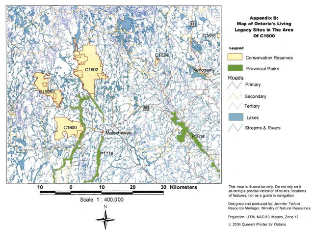
Enlarge Appendix B: Map of Ontario’s Living Legacy Sites in the area of C1600
Appendix C: Map of Wildlife Management Areas in C1600
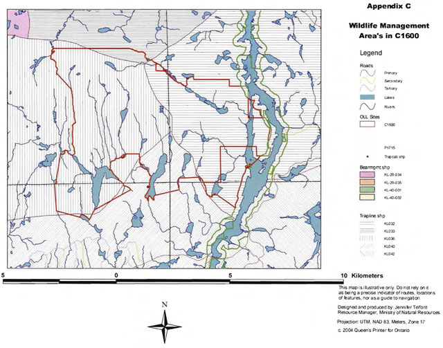
Enlarge Appendix C: Map of Wildlife Management Areas in C1600
Appendix D: Map of C1600 Wildlife areas
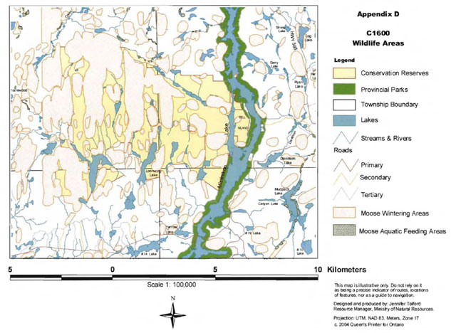
Enlarge Appendix D: Map of C1600 Wildlife Areas
Appendix E: Mistinikon Lake Uplands Conservation Reserve factsheet
Background
On July 16, 1999, the Ontario Government released the Ontario’s Living Legacy Land Use Strategy to guide the planning and management of Crown lands in central and parts of northern Ontario. A major part of the Ontario’s Living Legacy Land Use Strategy was a government intent to establish 378 new protected areas. This commitment marks the biggest expansion of provincial parks and conservation reserves in Ontario’s history. The proposed Mistinikon Lake Uplands Conservation Reserve is part of the significant expansion of Ontario’s protected areas system.
Size and location
The Mistinikon Lake Uplands Conservation Reserve, consisting of approximately 5,071 hectares of land. This site is found in Bannockburn, Powell, Argyle and Baden Townships in the District of Timiskaming.
Area highlights
This site contains strongly broken deep and shallow sandy till and bare bedrock dominates this upland site with white birch. Black spruce (331 to 100 years old), 31 to 70 year old jack pine, and polar/aspen complement the white birch stands. Old growth yellow birch (121+ years) is also represented within the candidate. This site is located just west of Mistinikon Lake with a number of good-sized, unnamed lakes throughout the southern section. An old fire lookout remains just west of Mistinikon Lake. The site contains scattered white pine, cliff communities, steep hills and kettle lakes.
Land use intent
Conservation reserves are areas of Crown land set aside by regulation under the Public Lands Act. Conservation reserves complement provincial parks in protecting representative natural areas and special landscapes. Most recreational; (e.g. hiking, skiing, tourism related uses, nature appreciation) and non-industrial (e.g. fur harvesting, commercial fishing and bait fishing) activities that have traditionally been enjoyed in the area will continue, provided that these uses do not impact on the natural features needing protection. Hunting and fishing are permitted within all new conservation [missing text]
Appendix 4: Procedural Guideline B - Land Uses-Test of Compatibility (PL Procedure 3.03.05)
The Conservation Reserve policy provides broad direction with regard to the permitted uses. The policy provides only an indication of the variety of uses that will be considered acceptable in Conservation Reserves. The only caution is that “any new uses, and commercial activities associated with them, will be considered on a case by case basis and, they must pass a test of compatibility to be acceptable.”
What does a “test of compatibility” mean? An examination of this must start from the premise of why an area is set aside-specifically, its representative natural heritage values. Criteria are then identified to guide compatibility considerations. These criteria apply to the long-term acceptability of both existing uses and new uses.
- Conformity to SCI/RMP: SCI describes values for which an area has been set aside and the range of appropriate uses that will be permitted in the area. SCI may also speak to the acceptability of other ’new’ uses currently not occurring in the area.
The first ’test’ is: “do proposed new land uses and/or commercial activities conform to the direction of the SCI/RMP for the Conservation Reserve? Would the new use(s) depart from the spirit of appropriate indicator land uses in the SCI/RMP?”
- Impact Assessment: If the proposed use(s) pass test 1 it is important to determine their impact on the area before they are approved. This should include the following:
- Impact on natural heritage values: “will the new use(s) impact any natural values in the area? If so, how and to what degree? Is it tolerable?”
- Impact on cultural values: “will the new use(s) impact any historical or archaeological values in the area?”
- Impact on research activities: “will the new use(s) affect research activities in the area?”
- Impact on current uses: “will the new use(s) have any negative impact on the array of current uses?”
- Impact on area administration: “will the new use(s) increase administrative cost and/or complexity?” (For example, the cost of area monitoring, security or enforcement).”
- Impact on accommodating the use outside the Conservation Reserve: “Could the use(s) be accommodated as well or better outside the Conservation Reserve?”
- Impact on socio-economics of the area: “will the new use(s) affect the community (ies) surrounding the area in a positive or negative way?” (For example, will the new use make an area less remote thereby affecting a local tourism industry that is dependent on the area’s remoteness for its appeal?).
- Impact on area accessibility: “does the new use(s) give someone exclusive rights to the area or a portion of the area to the exclusion of other existing uses?”
Appendix 5: Procedural Guideline C - Research Activities in Conservation Reserves
Purpose
To encourage contributions to the goal of conservation reserves by:
- Providing direction for research activities associated with conservation reserves: and
- Establishing a process for the review and approval of proposals by researchers, which could have an impact on the values protected by the conservation reserve.
Definition
Research means any investigation or study of the natural, cultural, social, economic, management or other features of characteristics of conservation reserves.
Guidelines
Research will be encouraged to provide a better understanding of the natural values protected by a conservation reserve and to advance their protection, planning and management. The Statement of Conservation Interest will define, for each conservation reserve, the key research issues, set out the parameters within which research may occur and identify research needs.
Applications and approvals
Researchers must apply in writing to the Area Supervisor for permission to conduct research. The request letter must contain a statement explaining why the proposed research should be undertaken in the particular conservation reserve in preference to another location.
Proposals will be reviewed and approved by the Area Supervisor, guided by the Statement of Conservation Interest prepared for each reserve (See Guideline A Resource Management Planning) and using Guideline 8- Land Uses-Test of Compatibility. Permission must be granted in writing, including any conditions to be met in conducting the research, prior to the undertaking of any research project.
Terms and conditions
Permission to conduct research under this policy will be valid for a period of 12 consecutive months from date of issue. Permission to continue a research project for additional periods of 12 months or less may be granted upon submission of a written request and progress report. The Ministry may require the posting of collateral to assure that the terms and conditions of granting permission are to be met.
The Area Supervisor may suspend or revoke permission at any time for failure on the part of the researcher to meet:
- The intent or conditions of this policy.
- The requirements under the Public Lands Act, including all amendments, where applicable.
- The requirements under any other Act or Regulations or Ontario or Canada, including those governing the taking, handling, storing, confining, trapping, excavating and marketing any specimen, artifact, information or action (for example, scientific collector’s permit).
- The conditions and agreements specified in granting permission.
Final report
The researcher will submit copies of reports, publications and theses following from the results of the project to the Area Supervisor.
Appendix 6: Crown Land Use Atlas - policy report
Ministry of Natural Resources ®Ontario
Crown Land Use Policy Atlas - Policy Report
C1600
Mistinikon Lake Uplands
Updated: June 29, 2004
Identification
ID: C1600
Area Name: Mistinikon Lake Uplands
Area (ha): 4,330
Designation: Conservation Reserve (Ontario’s Living Legacy)
MNR District(s): Kirkland Lake
Description
Strongly broken deep and shallow sandy till, and bare bedrock dominate this upland site with white birch. Black spruce (31 to 100 years old), 31 to 70 year old jack pine, and poplar/aspen complement the white birch stands. Old growth yellow birch (121+ years) is also represented within the candidate. This site is located just west of Mistinikon Lake with a number of good sized, unnamed lakes throughout the southern section. An old fire lookout remains just west of Mistinikon Lake. The site contains scattered white pine, cliff communities, steep hills, and kettle lakes.
Mistinikon Lake Uplands was regulated as a conservation reserve on May 8, 2002.
Land use intent
Management of this area is also governed by the general policies contained in the Land Use Strategy (1999).
Management direction
Those uses and management activities not listed in the following table are governed by existing conservation reserve policy. Over time the management direction will be elaborated in a Statement of Conservation Interest or Resource Management Plan. Any new uses, and commercial activities associated with conservation reserves, will be considered on a case by case basis, and they must pass a test of compatibility to be acceptable. Compatibility is normally determined through a planning process.
Commercial activities
| Activity | Permitted | Guidelines |
|---|---|---|
| Aggregate Extraction | No | |
| Bait Fishing Existing |
Yes | Existing use permitted to continue, unless there are significant demonstrated conflicts. |
| Bait Fishing New |
Maybe | New operations can be considered, subject to the “test of compatibility”. |
| Commercial Fishing Existing |
Yes | Existing use permitted to continue, unless there are significant demonstrated conflicts. |
| Commercial Fishing New |
Maybe | New operations can be considered, subject to the “test of compatibility”. |
| Commercial Fur Harvesting Existing |
Yes | Existing use permitted to continue, unless there are significant demonstrated conflicts. Existing trap cabins can continue; new cabins are not permitted. |
| Commercial Fur Harvesting New |
Maybe | New operations can be considered, subject to the “test of compatibility”. |
| Commercial Hydro Development | No | |
| Commercial Timber Harvest | No | |
| Commercial Tourism Existing |
Yes | Existing authorized facilities can continue, unless there are significant demonstrated conflicts. |
| Commercial Tourism New |
Maybe | New tourism facilities can be considered during the planning for an individual reserve. |
| Bear Hunting by Non-residents (guided) Existing |
Yes | Existing authorized operations permitted to continue. |
| Bear Hunting by Non-residents (guided) New |
No | New operations not permitted. |
| Outfitting Services Existing |
Yes | Existing authorized operations permitted to continue. |
| Outfitting Services New |
Maybe | New operations can be considered during the planning for an individual reserve. |
| Outpost Camps Existing |
Yes | Existing authorized operations permitted to continue. |
| Outpost Camps New |
Maybe | New operations can be considered during the planning for an individual reserve. |
| Resorts/lodges Existing |
Yes | Existing authorized facilities permitted to continue. |
| Resorts/lodges New |
Maybe | New facilities can be considered during the planning for an individual reserve. |
| Energy Transmission and Communications Corridors Existing |
Yes | These facilities should avoid conservation reserve lands wherever possible. |
| Energy Transmission and Communications Corridors New |
No | These facilities should avoid conservation reserve lands wherever possible. |
| Food Harvesting (Commercial) Existing |
Maybe | |
| Food Harvesting (Commercial) New |
Maybe | |
| Mineral Exploration and Development | No | |
| Peat Extraction | No | |
| Wild Rice Harvesting Existing |
Yes | |
| Wild Rice Harvesting New |
Maybe |
Land and resource management activities
| Activity | Permitted | Guidelines |
|---|---|---|
| Crown Land Disposition Private Use: |
Maybe | Sale of lands is not permitted, except for minor dispositions in support of existing uses (e.g. reconstruction of a septic system). Renewals of existing leases and land use permits are permitted. Requests for transfer of tenure will be considered in the context of the Statement of Conservation Interest or Resource Management Plan. New leases or land use permits permitted for approved activities. Tourism facilities can apply to upgrade tenure from LUP to lease. |
| Crown Land Disposition Commercial use |
Maybe | Sale of lands is not permitted, except for minor dispositions in support of existing uses (e.g. reconstruction of a septic system). Renewals of existing leases and land use permits are permitted. Requests for transfer of tenure will be considered in the context of the Statement of Conservation Interest or Resource Management Plan. New leases or land use permits permitted for approved activities. Tourism facilities can apply to upgrade tenure from LUP to lease. |
| Fire Suppression | Yes | Fire suppression policies are similar to adjacent Crown lands, unless alternative fire policies have been developed through a planning process. |
| Fish Habitat Management | Maybe | |
| Fish Stocking | Maybe | Conservation Reserves policy indicates that “featured species management” may be permitted. |
| Insect/disease Suppression | Maybe | |
| Inventory/Monitoring | Yes | |
| Prescribed Burning | Maybe | |
| Roads (Resource Access) Existing |
Yes | Existing roads can continue to be used. Continued use will include maintenance and may include future upgrading. |
| Roads (Resource Access) New |
Maybe | New roads for resource extraction will not be permitted, with the exception of necessary access to existing forest reserves for mineral exploration and development. |
| Vegetation Management | Maybe | Conservation Reserves policy indicates that Featured Species Management and Natural Systems Management may be permitted. Vegetation management can be considered in a planning process. |
| Wildlife Population Management | Maybe |
Science, education and heritage appreciation
| Activity | Permitted | Guidelines |
|---|---|---|
| Collecting | No | |
| Historical Appreciation | Yes | |
| Nature Appreciation | Yes | |
| Photography and Painting | Yes | |
| Research | Yes | |
| Wildlife Viewing | Yes | Conservation Reserves policy indicates that “featured species management” may be permitted. |
Recreation activities and facilities
| Activity | Permitted | Guidelines |
|---|---|---|
| All Terrain Vehicle Use On Trails: |
Yes | Existing use permitted to continue where it does not adversely affect the values being protected. ATV use off trails is not permitted, except for direct retrieval of game. |
| All Terrain Vehicle Use Off Trails: |
No | Existing use permitted to continue where it does not adversely affect the values being protected. ATV use off trails is not permitted, except for direct retrieval of game. |
| Campgrounds | Maybe | |
| Food Gathering | Yes | |
| Horseback Riding (trail) | Yes | Existing use on trails permitted. |
| Hunting | Yes | |
| Mountain Bike Use | Yes | Existing use on trails permitted. |
| Motor Boat Use Commercial: |
Yes | |
| Motor Boat Use Private: |
Yes | |
| Non-motorized Recreation Travel | Yes | |
| Private Recreation Camps (Hunt Camps) Existing |
Yes | Existing camps permitted to continue, and may be eligible for enhanced tenure, but not purchase of land. |
| Private Recreation Camps (Hunt Camps) New |
No | Existing camps permitted to continue, and may be eligible for enhanced tenure, but not purchase of land. |
| Rock Climbing | Maybe | |
| Snowmobiling On Trails: |
Yes | Except for the direct retrieval of game. |
| Snowmobiling Off Trails: |
No | Except for the direct retrieval of game. |
| Sport Fishing | Yes | |
| Trail Development Existing |
Yes | Development of trails for a variety of activities (e.g., hiking, cross-country skiing, cycling, horseback riding, snowmobiling) can be considered as part of planning for an individual reserve. |
| Trail Development New |
Maybe | Development of trails for a variety of activities (e.g., hiking, cross-country skiing, cycling, horseback riding, snowmobiling) can be considered as part of planning for an individual reserve. |
Note: The policies outlined in this table do not supersede any Aboriginal or treaty rights that may exist, or other legal obligations.
Management of this conservation reserve is carried out within the context of Conservation Reserve policy as amended by the policies for new conservation reserves outlined in the Ontario’s Living Legacy Land Use Strategy.
Source of direction
Ontario’s Living Legacy Land Use Strategy (1999)
Conservation Reserves Policy (1997)
Explanation of edits
[No information provided]
Appendix 7: Locator Map
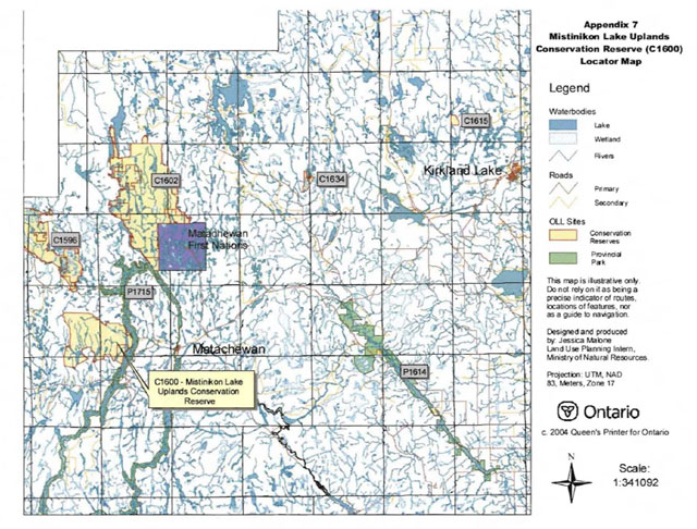
Enlarge Appendix 7: Locator Map
Appendix 8: Natural heritage - life science checksheet
- Name: C1600 Mistinikon Lake Uplands Conservation Reserve
- Map Name: Matachewan
- Map Number: 41P/15
- UTM Ref.: 515531
- Locality: Timiskaming
- Latitude: 47°57'10"W
- Longitude: 80°47'53"W
- NAD83: CNT
- Min. Alt.: 330 m
- Max. Alt.: 570 m
- Township: Bannockburn, Powell, Doon, Yarrow
- Area: 4686 ha
- Ownership: Crown
- MNR Region: Northeast
- MNR District: Kirkland Lake
- Ecoregion and Ecodistrict: 3E-5 (Hills 1959; Crins & Uhli 2000)
- Landform Unit(s) (preliminary)
- 9 Organic deposits
- 3e Till deposits - lineated till plain
- 2g Bedrock-Drift complex-talus slopes
- 2ac Bedrock-Drift complex-discontinuous predominantly till drift cover
- 2a Bedrock-Drift complex-predominantly till drift cover
- 1 Bedrock outcrop
- Aerial Photographs
- Year-Flight Line - Roll - Numbers
- 86-4733-04-211 to 215
- 86-4732-06-12 to 16
- 86-4731-26-107 to 111
Physical and biological features
Representation
The Mistinikon Lake Uplands Conservation Reserve (C1600) is located in the Kirkland Lake MNR District in the townships of Bannockburn, Powell, Doon and Yarrow approximately 10 kilometres west of the town of Matachewan. At 4686 hectares, it is comprised of vectored and biological boundaries and is linked to the West Montreal River Provincial Park at the east end. According to the OLL Land Use Strategy (1999), the CR is characterized by strongly broken deep and shallow sandy till and bare bedrock dominate this upland site with white birch. Black spruce, old jack pine and aspen complement the white birch stands and old growth yellow birch is also present. It also contains scattered white pine, cliff communities, steep hills and kettle lakes.
The conservation reserve is located in ecodistrict 3E-5 (Foleyet) of the ecoregion 3E (Lake Abitibi). The ecodistrict is characterized by gently rolling plains with thinly covered rock knobs, sandy outwash and silty depressions. Materials are generally granitic, locally overlain by low-base and low-lime materials. Deep deposits cover 25% of the area and the remaining areas have very shallow deposits (Keddy 1997). With the close association with ecoregion 4E and the Great Lakes-St. Lawrence forest, some sporadic occurrences of species having southern affinities, such as yellow birch, sugar maple and white pine, are present. The ecoregion, also called the Central Boreal Forest Region, is characterized by flat to gently rolling, glacial clay and sandplain with locally extensive peatlands and wetlands, broken throughout by glacial features such as moraines, eskers with Canadian Shield exposure. Regional vegetation includes spruce, poplar, and birch on fresh sites on moderately sloping terrain, white and red pine on sand ridges and American elm and white cedar in protected areas. The forest climate type is mid-humid, mid-boreal (Poser 1992; Noble 1983).
The CR is dominated by bedrock (Map 1b) according to the quaternary geology of Ontario layer and Noegts (Northern Ontario Engineering Geology Terrain Study) (Roed and Hallett 1979). Noegts further describes the area as having till ground moraine as a subdominant feature. During the aerial survey (Nicholson 2003), talus was observed at the bottom of a cliff at the northwest and southwest corners. According to Rik Kristjansson (2004), OLL geologist, the site is dominated by bedrock-drift complex with till being the dominant drift cover at times both continous and discontinuous (units 2a, 2ac). Along the mid-west and mid-south boundary drumlinized till (unit 3e) occurs where the slopes are more gradual. Minor areas of bedrock outcrops (unit 1) and organic deposits (unit 9) are scattered throughout the site. Talus slopes (unit 2g) are present on the base of some cliffs but they may not be delineated from the aerial photos.
The area is in Rowe’s (1972) B.7 section (Missinaibi-Cabonga) of the Boreal Forest Region. This section is along the height of land in central Ontario and the bulk of the forest is boreal but also contains within as scattered individuals or isolated patches species from the Great Lakes-St. Lawrence Forest. The predominant forest is mixed consisting of balsam fir, black spruce and white birch with scattered white spruce and trembling aspen. Jack pine occurs on sand terraces and can also be associated with black spruce on poor, rocky soils. Black spruce with tamarack covers wet organic soils and with cedar in other lowlands. The topography is rolling with numerous flats along the rivers and lake sides.
There are 31 forest communities (wetland FRI including) in the conservation reserve with 11 accounting for less than 1% of the total area (Map 2a, Appendix 2). The dominant communities include Bw predominant hardwood1 (24.5% of the total area), Bw hardwood mixed2 (15.9%) and Bw mixedwood (12.5%). The rest account for less than 10% and are dominated by black spruce, jack pine, aspen, yellow birch, white spruce or cedar. Supercanopy spruce and white pine are scattered throughout. Spruce was associated with the white birch forest communities while white pine was found along lake edges. Red maple was more common than was reported in the FRI (Nicholson 2003). Despite the large areas of bedrock, most of the forest communities were heavily stocked (Map 2b). Many of the pure Bw stands had no stocking but they were classed as barren-and-scattered blocks and many were associated with lowland areas. Lower stocking occurred in many valley bottoms. The majority of the stands are 65 to 75 years of age suggesting fire swept through the area in the 1930’s but according to the fire disturbance map (Appendix 1), only the northwest corner burned. Forest communities containing yellow birch were the oldest stands in the site, starting at 105 years of age. These yellow birch stands, based on Bridge et al. definitions (2000), were classified as old growth (Map 5, Appendix 2). The only other old growth occurs in a Sb dominant conifer stand on the mid-north boundary.
The forest communities are redefined as Standard Forest Units (SFUs), a more ecological approach to forests. The conservation reserve is dominated by BW1 (white birch poplar mixed hardwoods) (38.8% of the total area) and MW2 (rich upland mix) (24.5%). There are 8 other SFUs, such as SP1 (upland black spruce), PJ2 Uack pine-black spruce mix) and PO1 (poplar), which account for <10% each of the total area.
Wetlands3 are not a dominant feature of this conservation reserve and is mainly restricted to the many creeks (Map 3b). Many of the creeks contained shore fens and meadow marshes with the odd thicket swamp. Conifer swamps occur in a couple of Sb and Ce dominated forest communities.
The conservation reserve is situated in the 2Jd tertiary watershed of the Ottawa River major basin (OMNR 2002). Many of the creeks and small lakes in the site form headwaters to Mistinikon Lake and Montreal River. Walleye, northern pike and smallmouth bass are the fish species in Mistinikon Lake.
There is an abundance of early wintering area for moose (Map 3a). The forest communities are typical of early winter habitat; mature to over mature mixedwood stands. Late wintering habitat occurs in several areas and these areas are generally dense conifer forest communities.
Other values (Map 3a) include traplines KL032, KL033, KL036and KL040 and bear management areas Kl-29-034, Kl-29-035 and Kl-40-001. Several cottages are located on Mistinikon Lake.
Condition
Condition4 is the amount of disturbance whether it is caused by human or natural influences. For this conservation, the disturbance is rated low, almost pristine condition. Any disturbance was human related. An old camp was observed at the northeast corner of the unnamed lake in the southwest corner of the CR, with garbage strewn all around it (Nicholson 2003). Cottages are also situated on Bell Island and Mistinikon Lake. The other human disturbance was an abandoned fire tower at the southeast corner, just west of Mistinikon Lake. No roads or trails were observed.
Diversity
Diversity5 is a measure of the site’s life and earth science heterogeneity. It is based on the number and range (variety) of the natural landscape features and landforms for earth science values and the relative richness and evenness of the site’s life science components. Based on Ontario Parks (2003) analysis of the conservation reserve within ecodistrict 3E-5, diversity is rated as low. There were 7 landform:vegetation (L:V) combinations of which only bedrock was the landform present. The dominant formations were dense deciduous forest (35.96% of the total area) and mixed deciduous forest (24.65%) on bedrock. These 2 vegetation groupings are equivalent to the different white birch forest communities from FRI. Based on Kristjansson’s interpretation of the site, it is expected that the rating would remain low. The CR is dominated by 2 SFUs (BW1 and MW2) and basically 2 landform units (2ac and 3e). There are 8 other SFUs which only account for <10% each of the total area.
Wetlands add little to the diversity rating since it only accounts for 4.9% of the total area and it lacks variety. Development stages may add to the diversity rating. The 2 dominant SFUs are represented by immature, mature and old growth stages. The other SFUs are represented by at least immature communities with some including mature communities. Dispersion is another feature that could add to diversity since representation from each of the SFUs could be found across the CR. The cliffs on the west side add an unique feature to the site and support different plant life.
Evenness6 is the number of communities that control the vegetative nature of the site. If the site is equally represented by all its forest communities (SFUs) and FRI wetlands then evenness is considered even. For C1600, evenness is strongly skewed towards BW1, MW2 and SP1 (66.2% of the area total) and this has been reiterated several times. As a result of this skewness, diversity is greatly reduced in the CR.
Ecological considerations
Whenever possible, a site’s boundaries should be created to include the greatest diversity of life and earth science features to provide maximum ecological integrity. It should be ecologically self-contained, bounded by natural features and include adequate area to buffer the core ecosystems from intrusive influences (OMNR 1992). Mistinikon Lake Uplands Conservation Reserve is bound by a mixture of biological and vectored borders as well as the West Montreal River Provincial Park on the east side. Using many of the vectors is unavoidable as no natural features are present. If the forest reserve at the southeast corner is dropped from the site, it is suggested the replacement area would be the indentation on the south side (see Appendix 1 -Ecological Considerations). This would create a more round site and reduce the appearance of ’bite marks’ in the CR. As well, to shorten the length of one vector, a creek and lake could be used on the west side. This would also provide more protection to the cliff and talus slopes in that immediate area. This site is fairly round so much of the core area remained intact. An important design aspect of this CR is the linkage to the provincial park and ultimately to C1602 at the north end of the provincial park. It increases representation in a protected area and thus diversity.
Currently we do not have minimum size standards for conservation reserves under different landscape conditions. However, a minimum size standard of 2000 ha has been established for natural environment parks by Ontario Parks (OMNR 1992). This minimum standard was considered necessary to protect representative landscapes as well as allow for low intensity recreational activities. At 4686 hectares, it more than doubles the minimum standard. With its round shape and large size and many biological boundaries, the core areas are protected from any intrusive influences.
The ’pristine’ condition also makes it attractive for non-motorized recreational activities.
Special features
Special features include the ’pristine’ condition of the conservation reserve and the two cliffs on the west side. One is approximately 300 meters high and 2 kilometers long. Parts of this vertical rock face are vegetated with conifer trees. The other cliff is not as long or as high but it contains talus slopes on its lower half. Another special feature would be the rolling topography and the close resemblance it has to the Algoma Highlands in the Sault Ste. Marie area. The fire tower at the southeast corner would provide amazing views of the surrounding landscapes. The old growth yellow birch stands are the only areas that have a different age distribution. The rest of the site has a fairly even aged distribution.
Major information sources
Arnup, R., G.D. Racey and R.E. Whaley. 1999. Training manual for photo interpretation of ecosites in northwestern Ontario. NWST Technical Manual TM-003.127p.
Bridge, Simon; Watt, Robert; Lucking, Greg; and Brian Naylor. 2000. Landscape analysis for forest management planning in boreal northeastern Ontario. OMNR, Northeast Science & Technology. 36p.
Grins, W.J. and P. W. C. Uhlig. 2000. Ecoregions of Ontario: Modifications to Angus Hills' Site Regions and Site Districts - Revisions and Rationale.
Harris, A.G., S.C. McMurray, P.W.C. Uhlig, J.K. Jeglum, R.F. Foster and G.D. Racey. 1996. Field guide to the wetland ecosystem classification for northwestern Ontario. Ont. Min. Natur. Resour., Northwest Sci. & Technol. Thunder Bay, Ont. Field Guide FG-01. 74 pp. +append.
Hills, G.A. 1959. A Ready Reference to the Description of the Land of Ontario and its Productivity.
Keddie, C. 1997. Natural Heritage Gap Analysis for Site District 3E-5: GIS Analysis. by Geomatics International Inc.
Kristjansson, R. 2004. Personal Conversation.
Nicholson, J. 2003. C1600 Aerial Reconnaissance Notes.
Noble, T.W. 1983. Central Boreal Forest Region (3E). Life Science Report. Northeastern Region. Internal report.
Ontario Ministry of Natural Resources. 2002. MNR Districts and Major Basins of Ontario.
Ontario Ministry of Natural Resources. 1999. Ontario Living Legacy Land Use Strategy.
Ontario Ministry of Natural Resources. 1992. Ontario Provincial Parks: Planning and Management Policies-1992 Update.
Ontario Parks. 2003. Landform Vegetation Representation Summary for site C1600 in Ecodistrict 3E-5. (May 2003). Internal Report
Roed, M.A. and D.R. Hallett. 1979. Northern Ontario Engineering Geology Terrain Study, Data Base Map, Elk Lake. Ontario Geological Survey, Map 5020, Scale 1:100 000.
Rowe, J.S. 1972. Forest Regions of Canada. Department of Fisheries and the Environment-Canadian Forestry Service Publication No. 1300. 172p.
Taylor, K.C., R.W. Arnup, B.G. Merchant, W.J. Parton and J. Nieppola. 2000. A field guide to forest ecosystems of Northeastern Ontario. 2nd Edition. Northeast Science and Technology Nest Field Guide FG-001.
Thompson, John E. & Jake Noordhof. 2003. Edit Model for N.E. Region Life Science Checksheets. Internal Report. Uhlig, P., A. Harris, G. Craig, C. Bowling, B. Chambers, B. Naylor and G. Beemer. 2001. Old growth forest definitions for Ontario. Ont. Min. Nat. Res., Queen’s Printer for Ontario, Toronto, On. 53p.
Significance level (provincial/regional/local) and brief summary of major representative values
The OLL Land Use Strategy (1999) states the site contains white birch with black spruce, jack pine and aspen stands on strongly broken deep and shallow sandy till and bare bedrock. Old growth yellow birch, scattered white pine, cliff communities, steep hills and kettle lakes are also present. That was based on the blue line boundary (Appendix 1 - History map). The new regulated boundary and forest communities have not changed significantly from the original one. White birch is the dominant tree species with black spruce and jack pine scattered throughout. Stands consisting of yellow birch were generally the only old growth. According to Rik Kristjansson, the CR is dominated by bedrock-drift complex of various depths but it is not the only landform in the site. Several areas, particularly on the west, southwest and mid-south sides, are characterized by drumlinized till and throughout the CR are minor areas of organic deposits or bedrock outcrops.
Based on the analysis by Ontario Parks (2003), the conservation reserve is not provincially significant. The different vegetation types on bedrock are amply represented (protected) elsewhere in the ecodistrict. If these same vegetation types were analyzed with till, one can observe that these combinations too are represented elsewhere in the ecodistrict. This conservation reserve needs to be analyzed based on SFUs and new landform types to determine the significance within the ecodistrict.
Sensitivity
Potentially, the conservation reserve could be susceptible to exterior land use activities along vectored boundaries unless they are clearly marked. Encroachments from cottages along Mistinikon Lake are always a possibility.
Recommendations
- This second step checksheet should be advanced to a fourth step by digitizing the earth science data based on Kristjansson’s interpretations of aerial photos, once these become available and used with SFU to complete a current landform:vegetation analysis. Finally, the checksheet could be advanced to a fifth step by comparing the fourth step checksheet with the current provincial landform layers based on the new regulated boundary to see if comparisons can be made. In turn we can determine more fully the site’s significance and contribution to the parks and protected areas program.
- The vectored boundaries for the site should be marked to ensure that the values within the site are protected from surrounding land use activities. Further analysis and assessment may require additional management prescription to ensure long term protection of the site’s natural heritage values.
- Using the fire lookout tower to view the landscape by possibly linking with the Provincial Park and canoe route. As well, hiking trails could be created on the cliffs on the west side for spectacular views of the surrounding landscape.
- Alter some of the vectored boundaries to create more ecological boundaries as indicated in the Ecological Considerations map (Appendix 1) and to reduce the risk of any trespassing. If areas are lost due to OPA/PPL disentanglement, the suggested replacement area is on this map. Much of the area surrounding the CR is similar to the interior except harvesting as occurred mid-north, southwest and south of the site.
- Funding should be secured in the near future to determine the number and location of roads and trails currently present within the site using current global positioning technologies.
- Any future trail development must consider the values found within the boundaries of the site, the rationale for developing trails within the site and the availability of current access through the site and surrounding areas. Furthermore, any new trail development will require a ’Test of Compatibility’. Low-lying areas and wetlands should be avoided.
- Overall custodial management is the responsibility of the district office with support from the regional natural heritage specialist and Ontario Parks. To advance conservation reserve custodial management, future managers will need to monitor the current state of the CRs resources at least at the community and landscape levels within and adjacent to the conservation reserve and its surrounding environment. Such monitoring could include: evaluating and reporting on changes such as; natural disturbances (i.e. fire, insect/disease, wind throw, etc.), human disturbances (i.e. forest harvesting, access and/or other land use activities) as well as management prescriptions (i.e. rehabilitation efforts and/or vegetative management planning).
- Ongoing evaluations and reports will have to rely on current and new technologies such as satellite imagery, global positioning systems (GPS), supplementary aerial photography (SAP) and/or aerial/ground reconnaissance surveys/assessments conducted periodically and placed within a GIS database. Such tools could help managers spatially record areas affected severity of perturbations or management action as well as consider the sensitivity of values, the design of CR and determine the future desired condition of the site. Monitoring efficiencies could be enhanced via partnerships and internal coordination within MNR.7
Time effort spent on site
September 22, 2003 1:30 to 2:30pm
Date Compiled
March 10, 2004
Compiler(s)
Barbara Burkhardt, Lori King, Sean Longyear
Date Reviewed
[no information provided]
Reviewer
[no information provided]
1Conifer stands are defined as follows: pure conifer stands contain 100% of a conifer trees in the canopy; dominant conifer stands contain less than 10% cover of hardwoods in the main canopy and predominant conifer stands contain less than 20% cover of hardwoods in the main canopy. Similarly hardwood stands may contain no conifer in canopy (pure hardwood), less than 10% conifer (dominant hardwood) or less than 20% conifer cover (predominant hardwood) (modified after Taylor et al. 2000).
2Mixedwoods are defined as follows: hardwood mixedwoods are stands dominated by hardwoods with less than 30% cover of conifer in the main canopy; similarly conifer mixedwoods contain less than 30% hardwoods in the canopy. Mixedwoods contain approximately equal percentages of conifer and hardwood trees and true mixedwoods contain a 50:50 split between conifers and hardwoods (modified after Taylor et al. 2000).
3Wetlands were classified after Arnup et al. 1999 and Harris et al. 1996.
4Rating based on the amount of area currently under some form of known disturbance. High is >20% of the area, medium 10 to 20%, low <10% and pristine <1%.
5Diversity rating, developed by John Thompson & Jake Noordhof (2003), is based on the size of the conservation reserve versus the number of landforms:vegetation (SFU/HU) combinations. For CR’s <500 ha, high diversity is >25 L:V combinations, medium for >15 L:V, and low for <15 L:V. For areas 500-2000 ha, high is >30, medium >20 and low <20. For areas >2000 ha, high >35, medium >25 and low <25 L:V combinations.
6Evenness of the site defined as strongly skewed (top 3 communities capture >=60% of the site in area), moderately skewed (30-59%) or slightly skewed to even (<30%).
7Coordination could include a variety of expertise from the following: Field Services Division, Ontario Parks, Aviation and Forest Fire Management Branch, Forest Health and Silvicultural and Forest Management Planning Sections, Northeast Science and Information etc. Additional expertise within and outside the MNR could be sought as required.
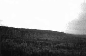
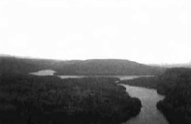
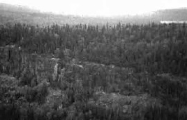
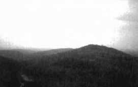
Map 1a - Surficial Geology

Enlarge Map 1a - Surficial Geology
Map 1b - Geology
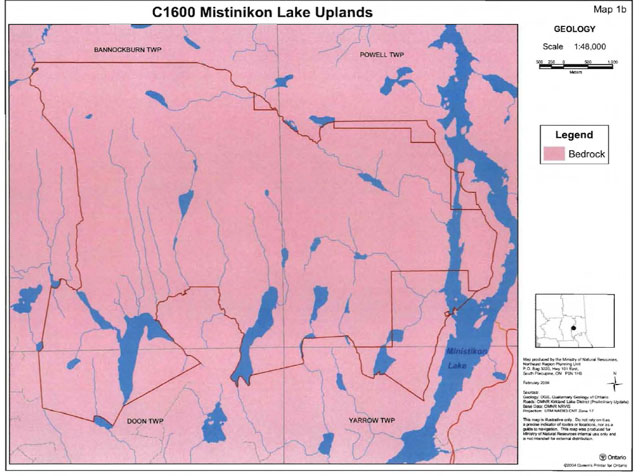
Map 2a - Forest Communities
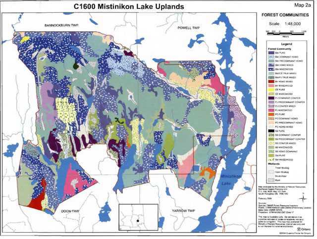
Enlarge Map 2a - Forest Communities
Map 2b - Stocking distribution
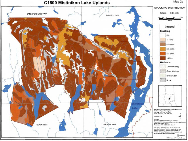
Enlarge Map 2b - Stocking distribution
Map 2c - Age distribution
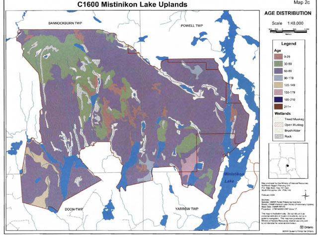
Enlarge Map 2c - Age distribution
Map 2d - Standard Forest Units
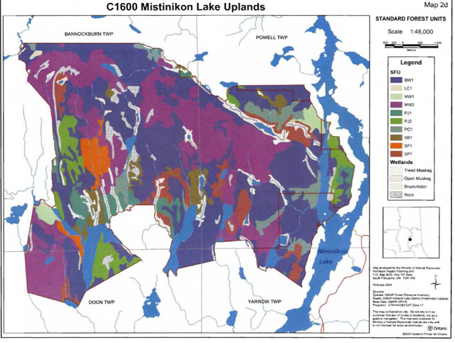
Enlarge Map 2d - Standard Forest Units
Map 3a - Values map
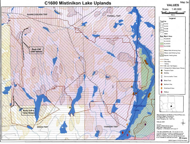
Map 3b - Wetlands map
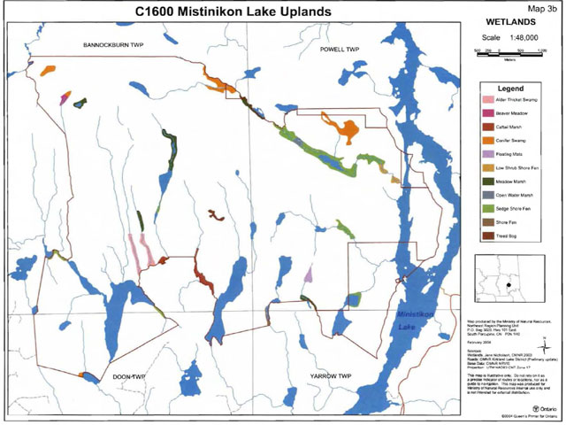
Map 5 - Old Growth map
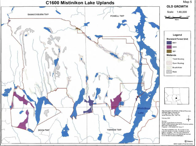
Enlarge Map 5 - Old Growth map
Map 6 - C1600 Road Access
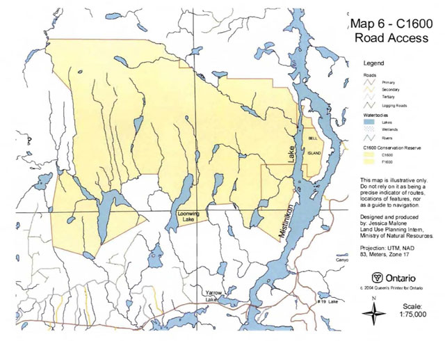
Enlarge Map 6 - C1600 Road Access
Landform Vegetation Combinations Map
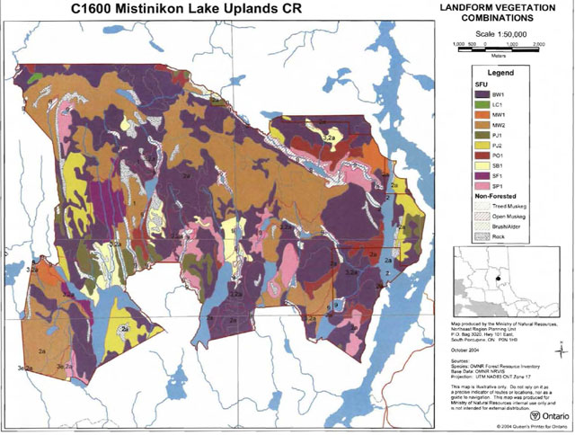
Enlarge Landform Vegetation Combinations Map
Fire Disturbance Map
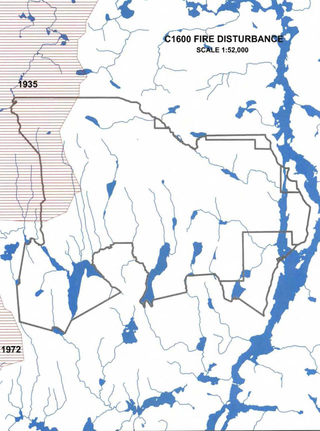
History Map
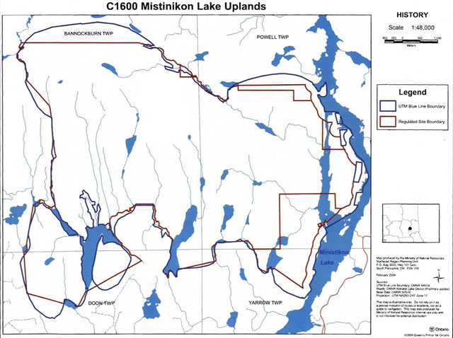
Plan of C1600 Mistinikon Lake Uplands Conservation Reserve
Enlarge Plan of C1600 Mistinikon Lake Uplands Conservation Reserve
Appendix 9: Earth science checksheet
Mistinikon Lake Conservation Reserve (C1600) Approved Earth Science Checksheet
Kirkland Lake
January 26, 2005
Prepared by: F.J. (Rik) Kristjansson
Earth science inventory checklist
- Name: Mistinikon Lake (C1600)
- Map Name: Matachewan
- NTS Number: 41 P/15
- UTM Ref. (Datum): 515531
- Latitude: 47° 57’ 10" N
- Longitude: 80° 47’ 53" W
- Elevation (Mininum): 330m asl
- Elevation (Maximum): 570 m asl
- Locality: Timiskaming
- Township(s): Bannockburn, Powell, Doon, and Yarrow
- Area (ha): 4686 ha
- MNR District: Kirkland Lake
- MNR Region: Northeast
- Aerial Photographs:
- 86-04,4733, 210 to 216
- 86-06, 4732, 11 to 17
- 86-26, 4731, 106 to 112
- Prepared by: F.J. Kristjansson, Consulting Geoscientist
- Reviewed by: Phil Kor, Senior Conservation Geologist
- Date: January 26, 2005
Earth science features
Bedrock geology
Based on Map 2543 (Ontario Geological Survey, 1991) and Map P.159 (Savage et al., 1962), the Mistinikon Lake Conservation Reserve is almost entirely underlain by undifferentiated sedimentary rocks of the Gowganda Formation, Cobalt Group, Huronian Supergroup, Southern Province, Precambrian Shield. In addition, several minor areas, located in the extreme north central and northeast parts of the conservation reserve, are underlain by undifferentiated igneous rocks of the Abitibi Subprovince, Superior Province, Precambrian Shield.
Surficial geology
Based on a brief helicopter reconnaissance survey, review of terrain geological mapping (Roed and Hallett, 1979, Data Base Map 5020), and interpretation of available aerial photography, the Mistinikon Lake Conservation Reserve is immediately underlain by areas of Bedrock Outcrop (Unit 1), Bedrock-Drift Complex (Units 2a and 2), Till Deposits (Units 3, 2a and 3e, 2a), and Organic Deposits (Unit 9). Please refer to the attached preliminary surficial geological mapping for the occurrence and distribution of these surficial geological units within the conservation reserve (Appendix A).
Bedrock terrain, essentially a complex of bedrock-controlled uplands and adjacent lowlands, dominates the surficial geology of the conservation reserve (Photo. C1600-01). With reference to the morphology ofthe bedrock surface, bedrock knob (or knoll) forms are most characteristic, although bedrock ridge forms are dominant in the extreme west part of the conservation reserve. A well-developed, bedrock escarpment, which trends approximately north-south, is also located in the extreme west part of the conservation reserve (Photo. C1600-02, and Photo. C1600-03). The escarpment feature occurs discontinuously in the immediate vicinity of, or a short distance from, the west boundary of the conservation reserve, and is depicted on the attached preliminary surficial geological map with the scarp symbol. Talus deposits were observed at the base of the escarpment feature (Photo. C1600-03).
With the exception of two areas of Bedrock Outcrop (Unit 1) in the central part of the west half of the conservation reserve, bedrock terrain within the conservation reserve, that is, the mainland and Bell Island parts of the conservation reserve, is classified as Bedrock-Drift Complex (Units 2a). Major bedrock exposure (>75% is estimated) and thin, discontinuous drift is expected in areas of bedrock outcrop. Moderate (to minor) bedrock exposure associated with a thin, discontinuous (to thin, but relatively continuous) cover of drift is generally anticipated within areas of bedrock-drift complex. It is considered very likely that the associated drift cover consists of till deposits.
The extreme east part of the conservation reserve has encompassed a portion of Mistinikon Lake, situated between the mainland and Bell Island. This open water portion of the conservation reserve contains a number of islands. One of the islands is classified as Bedrock Outcrop (Unit 1), and is thought to be mostly bare bedrock. The remaining islands are mapped as Bedrock-Drift Complex (Unit 2), and the associated sediment cover probably consists of thin, discontinuous deposits of till and/or stratified sediment (e.g., glaciolacustrine deposits).
The conservation reserve also contains a number of areas immediately underlain by Till Deposits (Units 3,2a and 3e,2a). As a general statement, these deposits are associated with the lower elevation areas in the central and south parts of the conservation reserve. The till deposits located in the extreme southwest part of the conservation reserve appear to be part of a drumlinized till plain, and, as such, were classified as Unit 3e,2a. As indicated by the compound map unit designations (i.e., Units 3, 2a and 3e, 2a), subordinate, but difficult to delineate, areas of bedrock-drift complex, in this case, bedrock-till complex, may also be present.
Finally, various minor areas immediately underlain by Organic Deposits (Unit 9) are present within the conservation reserve.
Significance
The geological features described above are commonly encountered within the surrounding region, and are considered to be of local significance.
Sensitivity
Considering the relatively passive land uses anticipated within a conservation reserve (e.g., hunting), the various geological features are considered to have low sensitivity.
Recommendations
None
References
Ontario Geological Survey, 1991; Bedrock Geology of Ontario, East-Central Sheet; Ontario Geological Survey, Map 2543, Scale 1:1,000,000.
Roed, M.A., and Hallett, D.R., 1979; Northern Ontario Engineering Geology Terrain Study, Data Base Map, Elk Lake; Ontario Geological Survey, Map 5020, Scale 1:100,000.
Savage, W.S., Thomson, R., and Fenwick, K.G., 1962; Bedrock Geology, Elk Lake-New Liskeard Sheet, District of Timiskaming; Ontario Department of Mines, Compilation Series, Preliminary Geological Map No. P.159, Scale 1 inch to 2 miles.
Appendix A: Preliminary Surficial Geology of the Mistinikon Lake Conservation Reserve (C1600)
Photographs
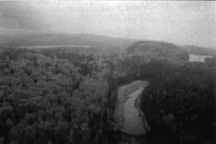
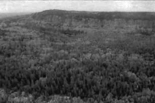
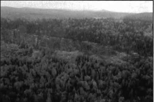
Appendix 10: James Bay Treaty
The James Bay Treaty - Treaty No. 9
Appendix 11: Robinson Treaty
Cat. No. Ci 72-1264