Mojikit Lake Conservation Reserve Management Statement
This document provides policy direction for the protection, development and management of the Mojikit Lake Conservation Reserve and its resources.
Statement of Conservation Interest (C2242)
Ministry of Natural Resources
Thunder Bay District
January 2003
Information Management
By Jason Biggar
Thunder Bay District
Approval Statement
We are pleased to approve this Statement of Conservation Interest for Mojikit Lake Conservation Reserve.
This Statement of Conservation Interest provides guidance for the management of the Conservation Reserve and the basis for the ongoing monitoring activities. More detailed direction is not anticipated at this time. Should significant facility development be considered or complex issues arise requiring additional studies, more defined management direction, or special protection measures, a more detailed Conservation Reserve Management Plan will be prepared with full public consultation.
The public was widely consulted during the designation and regulation of the site and further consultation is not required at this time.
The Conservation Reserve will be managed under the jurisdiction of the Spruce/Armstrong Area Team. thunder Bay District, of the Ministry of Natural Resources.
Signed by:
W. D. Baker
District Manager
Thunder Bay District
Date: May 29, 2003
Signed by:
Charlie Lauer
Regional Director
Northwest Region
Date: June 27, 2003
1.0 Map overview
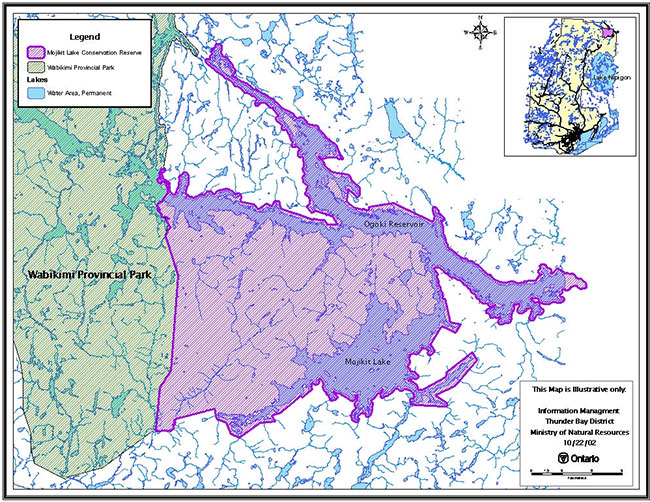
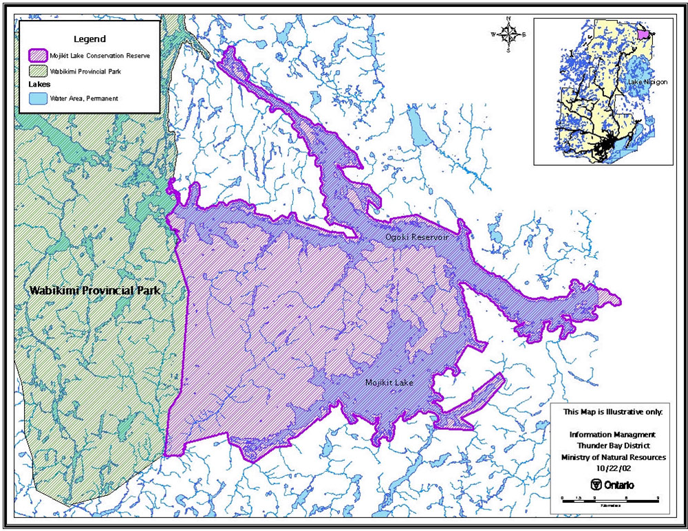
2.0 Background information
The purpose of this document is to identify the natural heritage values of Mojikit Lake Conservation Reserve, and to protect those values by establishing management guidelines for existing and potential uses in this area given the level of past disturbance and the nature of the existing features. This document provides management direction until more comprehensive planning occurs.
2.1 Background information
| Name | Mojikit Lake Conservation Reserve |
|---|---|
| Site Region / Site District | 3W-1 |
| OMNR Administrative Region / District / Area | Northwest Region/Thunder Bay District/Spruce River/Armstrong Area |
| Total Area (ha) | 62,602 hectares |
| Regulation Date | Anticipated 2003 |
| First Nations | Whitesands (Independent) and Fort Hope (Treaty 9) |
| OBM | 2016390056000, 2016390056100, 2016390056200, 2016400056300, 2016400056200, 2016400056100, 2016410056200, 2016410056100, 2016420056200, 2016420056100 |
| Latitude/Longitude | 50° 45' N/ 88° 30' W |
| Basemap | 39560, 39561, 39562, 39553, 40563, 40562, 40561, 41562, 42561, 42562 |
| Forest Resource Inventory | 1986 FRI. |
| General Location Description | Mojikit Lake Conservation Reserve is located approximately 50 km northeast of Armstrong and 50 km north of Lake Nipigon. Mojikit Lake Conservation Reserve is located in the Armstrong Forest and the northern shoreline falls within the Ogoki Forest. Wabakimi Provincial Park is located to the west side of the conservation reserve. |
| Access | Mojikit Lake conservation reserve has no vehicular access. The only access at this time would be by air, through one of the many tourist outfitters or by canoe through Wabakimi Park and Ogoki River. |
2.2 Representation targets
This section provides a summary of the earth science, life science and cultural values represented in the site. Existing and potential recreational opportunities are also summarized.
| Life Science Representation | The high diversity of landforms in this conservation reserve supports a very high variety of wetland habitat and consequently wildlife habitat. The unique dune and peatland complexes of Mojikit Lake Conservation Reserves interior portion has the potential to support a high plant diversity including regionally rare species as well as act as wintering caribou habitat which is provincially significant. In addition, the conservation reserve provides a continuous protected link between Wabakimi Provincial Park and the Ogoki River Provincial Park. |
|---|---|
| Earth Science Representation | This site contains regionally significant sand dune complexes. The sand dune complexes outside the conservation reserve within the two proposed boundary extensions are the best-known relict dune landscapes in Ontario. This level of significance only applies should the proposed extensions be implemented. The Nakina Moraine exposure within the proposed northeastward extension should be ranked as provincially significant for interpretive, educational and scientific values. The raised beach ridges are ranked as regionally significant for scientific and educational values. Glacial Lake Nakina landforms are not abundant in this area and these beach ridges may provide useful information relating to the late stages of the lake. |
| Recreational Opportunities | Remote Hunting, Fishing, Canoeing and Kayaking |
2.3 Survey information
This section provides an overview of the inventories completed, their level of detail and any further inventories that are needed.
| Survey level | Completed | Future requirements |
|---|---|---|
| Life Science | Reconnaissance Level Survey 2002 North-South Environmental Inc. | The continued effects of raised water levels on the marshes should be monitored. The use of the unique sand dune and peatland complexes by caribou should be investigated further. |
| Earth Science | Reconnaissance Level Survey 2002 North-South Environmental Inc. | None. |
| Recreational | Recreation Resource Inventory Completed May 2002. | A study of summer canoe and kayak usage from Wabakimi Park to the Ogoki river. |
3.0 Values to be protected
This section provides a description of the natural heritage values for the Mojikit Lake Conservation Reserve and their condition relative to past resource use, management activities and their sensitivity to future land use and management.
3.1 Values identified for protection on the site
3.1.1 Earth science values
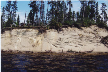
The majority of the bedrock within the Mojikit Lake Conservation Reserve was found to be Neo to Mesoarchaen in age. These have been intruded by later Paleoproterozoic diabase dikes and Keweenanwan diabase sills, which are found mostly in the southern part of the conservation reserve. The bedrock of this conservation reserve are best displayed along the north and west arms of the Ogoki Reservoir. The shorelines in this area consist of weakly to moderately broken bedrock knolls of gneisses and granites. Nonetheless, the interior of the conservation reserve does not have significant bedrock exposures. The interior portions are dominated by aeolian sand dunes with intervening peatlands.
The Mojikit Lake and Ogoki Reservoir area presents a terrain which consists of occasional glaciofluvial clay plains, small esker complexes with kettle lakes, and at least one glacialfluvial outwash deposit. The small esker complex lies on the south shore of the southwest arm of Mojikit Lake. It consists of about two low esker ridges separated and surrounded by several small kettle lakes and wetlands. The Nakina Moraine is also depicted within this conservation reserve and may have been the source of many of the very fine sands, which constructed the surrounding sand dune complexes. The current boundaries of the conservation reserve capture only a very narrow portion of the moraine, hence the recommended boundary extension by North-South Environmental Inc. This moraine system is Late Wisconsinian and represents the last known major still-stand of the Laurentide Ice Front as it retreated to the northeast. One large glaciolacustrine silty clay plain with low washed rock knobs forms the peninsula in the north end of Mojikit Lake. Following the drainage of Glacial Lake Nakina, the landscape of this area was dominated by poorly vegetated sand plains and ridges represented by the Nakina moraine and other lake deposits. These sands would have been susceptible to wind erosion and re-deposition into sand dune complexes. The combination of strong winds, abundant sand, a low relief topography and low vegetation resulted in the formation of an extensive aeolian landscape consisting of high sand dunes. The sand dunes should not be disturbed in any way. The high water levels created by the development of the reservoir have resulted in significant erosion of many of the dunes. No further development or raising of existing control levels is recommended.
Image of the Mojikit Lake and Ogoki Reservoir terrain:
3.1.2 Life science values
The majority of Mojikit Lake Conservation Reserve is dominated by aspen as both hardwood and mixedwood forest. The Sand Dune Ogoki Reservoir interior portion of the reserve between Mojikit Lake and Ogoki Reservoir is dominated by extensive black spruce. Jack pine and black spruce dominate the sand dunes, well open and low shrub fens occur in the low-lying areas between the sand dunes. Extensive marshes can also be found throughout the conservation reserve containing cattail, wild rice, and horsetail.
The Ogoki Reservoir was created to augment water levels in the Lake Nipigon watershed for hydropower generation. A combination of logging adjacent to the conservation reserve, increased water levels associated with the reservoir and narrow buffer widths have resulted in extensive windthrow in the mixedwood forests. Forest fires around Mojikit Lake have occurred within the last 5 years. This conservation reserve has also been developed for recreation; especially fishing and hunting, by way of numerous remote outpost camps, which are present throughout the reserve. The large variety of landforms within this conservation reserve supports a high diversity of wetland and wildlife habitat. The extensive peatland and sand dune complexes within the conservation reserve have the potential to support high plant diversity including the potential for regionally rare species. The continued effects of raised water levels on the marshes of the conservation reserve should be monitored. The unusual dune and peatland complexes of the interior portion have the potential to act as wintering caribou habitat. Also, the presence of immature bald eagles within the reserve indicates the possibility of nesting sites. In addition, the conservation reserve provides a continuous protected link between Wabakimi Provincial Park and Ogoki River Provincial Park.
3.1.3 Recreational values
Two lakes encompass Mojikit Lake Conservation Reserve, Mojikit Lake and the Ogoki Reservoir; both offer unique recreational opportunities, like canoeing, kayaking and sport fishing. The Ogoki Reservoir was created in the early 1940's to divert water from the Ogoki River within the Arctic watershed into Lake Nipigon in the Atlantic watershed. One of the most important recreational features within Mojikit Lake Conservation Reserve is the sport fish. The remoteness of the site and the sport fish such as Walleye and Northern Pike offer an international draw for fishermen. Approximately half a dozen different outpost camps are located within or near the conservation reserve, all which supply ample opportunity for fishing. Since reaching Mojikit Lake Conservation Reserve is limited to air travel, mostly by floatplane, the attraction is for the sport fish in a remote setting. The reserve offers unique wildlife viewing opportunities of caribou and some particular bird species, such as bald eagles, osprey, and terns. Caribou have a very high sensitivity to recreational use within the conservation reserve. Air and boat traffic can interfere with the caribou when calving and at water crossings. Caribou also have a very high sensitivity to resource development. Moose hunting is another feature most tourist outfitters within the Conservation Reserve offer their clients.
4.0 Management guidelines
All management activities must conform to the stated intent and direction of this Statement of Conservation Interest. New activities, which do conform, must also be assessed for potential impacts on resource values. Values that have been identified in particular, those noted in sections 3.0, should not be negatively impacted. Management activities are subject to the Environmental Assessment Act.
4.1 Land tenure
Mojikit Lake Conservation Reserve’s boundary is delineated by three water control structures operated and maintained by Ontario Power Generation, Snake Creek Dam, Waboos Dam and the Summit Dam, all have a crown lease (CL 2485). The Ontario Power Generation in conjunction with the Ministry of Natural Resources Nipigon District will release a water management plan in the year 2004. The plan will include the three aforementioned water structures, found on the Little Jackfish River, Ogoki River and Mojikit Lake, will deal with water levels and flows for the area. All three dams have a License of Occupation as well (LO 6192), with the right to flood to 1075 feet in elevation.
Mojikit Lake Conservation Reserve also accommodates eight remote outpost camps each with their own 'Land Use Permit'. One other outpost camp operates on the Ogoki Reservoir, but it is situated within the Wabakimi Provincial Park area. The entire area within and surrounding Mojikit Lake Conservation Reserve is Crown land. Wabakimi Provincial Park delineates some of conservation reserve’s boundary to the west, while Ogoki River Provincial Park outlines the east tip of Mojikit Lake Conservation Reserve.
- No dispositions (including Land Use Permits, Leases or Licenses of Occupation) will be issued for the site for industrial purposes
- Sale of Crown lands within the proposed conservation reserve is not permitted. Renewals of existing leases or land use permits are permitted. Operators of tourism facilities can apply to upgrade tenure from Land Use Permit to lease
- No new tourism facilities or Land use Permits will be issued within the conservation reserve
4.2 Existing and proposed development
Mojikit Lake Conservation Reserve has no vehicular access. At this time access is limited to air travel, mostly by floatplane and canoe, kayak routes from either Wabakimi Park or Ogoki River Park. There are three existing water control structures that help delineate the conservation reserve boundary, as well as eight remote outpost camps with 'Land Use Permits' within the conservation reserve. There are no existing campsites, parking lots, authorized trails, or waste disposal sites within the Conservation Reserve.
- New resource access roads are not permitted. Trail development may be considered to enhance nature appreciation or recreational activities as long as it is determined that the new trail would not interfere with natural processes
- Non-trail use by motorized vehicle will only be permitted for the retrieval of game
4.3 Recreational activities
Recreational activities that have traditionally been enjoyed in this area can continue provided they pose no threat to the natural ecosystems and features protected by the Conservation Reserve. Traditional winter route uses (i.e. ATV and snowmobile use) upon lakes; rivers and portages will be allowed to continue.
- Hunting and fishing activities will continue to be allowed as regulated uses by the Ministry of Natural Resources
- Non-regulated uses (i.e. ATV and snowmobile use) will be permitted as long as they do not adversely affect the values. Effects of recreational use will be monitored on an on-going basis
- Existing and new fishing and hunting activities are permitted
- Camping is permitted within the Conservation Reserve
4.4 Commercial and industrial activities
Conservation Reserves do not permit mining, commercial forest harvesting, hydroelectric power development, the extraction of aggregate peat, soils, or other industrial uses. New commercial activities for tourism facilities maybe considered.
4.4.1 Forest management activities
The Mojikit Lake Conservation Reserve is located within both the Armstrong Forest and Ogoki Forest and will be withdrawn from the Sustainable Forest Licenses.
- Forest Management Activities are not permitted within the Conservation Reserve
4.4.2 Commercial trapping activities
Current trapping activities will be permitted to continue, unless there are significant demonstrated conflicts. Trapline areas are a permitted use and may continue within the conservation reserve.
- New cabins will not be considered
- Repair and replacement of existing cabins are permitted, as long as the scale and function are not significantly altered
4.4.3 Bear management activities
Bear hunting operations may continue in this Conservation Reserve. Bear management areas are a permitted use and may continue within the conservation reserve.
- The transfer of licenses will be permitted on an ongoing basis
4.4.4 Commercial baitfish activities
- New operations may be considered and are subject to a test of compatibility
4.4.5 Mining exploration and aggregate extraction activities
- Mineral exploration and extraction is not permitted within the Conservation Reserve
- Aggregate peat and soil extraction is not permitted within the Conservation Reserve
4.4.6 Resource access roads
New resource access roads will not be permitted
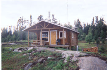
4.4.7 Outpost camps / tourism facilities
Existing authorized outpost camps and tourism facilities can continue unless demonstrated conflicts. Operators can apply for upgrade tenure from LUP to lease. New facilities will be considered subject to more detailed planning.
Image of the existing authorized outpost camps and tourism facilities:
4.5 Aboriginal interests
Mojikit Lake Conservation Reserve is included in the Robinson-Superior and Treaty Nine areas, more specifically Whitesands and Fort Hope First Nation traditional use area. Aboriginal interest within the Mojikit Lake Conservation Reserve span from remote Outpost Camp – west ogoki reservoir outpost camp ownership and operation, to trapping and hunting. This Statement of Conservation Interest in no way affects any existing or future aboriginal or treaty rights.
4.6 Natural Resources Stewardship
Natural Resource Stewardship involves the consideration of the following specific natural resource management categories.
4.6.1 Vegetation and fire management
Mojikit Lake Conservation Reserve has an extensive peatland and sand dune complex that potentially could support a high plant diversity including the possibility for regionally rare species. The variety of landforms within this reserve also supports a very high diversity of wetland habitat. Management within the Conservation Reserve will allow for the continuation of natural ecosystem processes and functions with minimal human interference.
The OMNR recognizes fire as an essential process fundamental to the ecological integrity of this conservation reserve. Forest fire protection will be carried out as on surrounding public lands in accordance with existing conservation reserve policy and the Forest Fire Management Strategy for Ontario. The MNR fire program will endeavor to use "Light on the land" techniques, which do not unduly disturb the landscape, whenever feasible in this conservation reserve. Examples of light on the land techniques may include limiting the use of heavy equipment and foam, and limiting the number of trees felled during fire response efforts. Opportunities for prescribed burning to achieve resource management objectives will be considered. Plans for any prescribed burning will be developed in accordance with the OMNR Prescribed Burn Planning Manual.
Fire is recognized as the primary agent of natural disturbance in this conservation reserve, and will be considered in subsequent planning activities.
- Forest insect and disease management will be addressed on a site basis
4.6.2 Fish and wildlife management
Threatened species such as caribou and the bald eagle have been identified within and around the boundary of Mojikit Lake Conservation Reserve. A 1 km buffer around the conservation reserve boundary has been designated as an "Area of Concern" due to the native caribou calving areas and summer habitat. Caribou studies have been taking place since the mid-1990's and will continue with studies focusing on winter habitats and specific conditions for calving areas.
No significant fish habitats have been identified in the Conservation Reserve. Should new information warrant it, fish management policies may be added as an amendment to this Statement of Conservation Interest.
- Sport Hunting and fishing will be allowed to continue within the reserve
4.6.3 Landforms
The sand dune complexes are currently ranked as regionally significant. The raised beach ridges are ranked as regionally significant for scientific and educational value. Any changes to the water level regime, which will be stated in the Nipigon River Watershed Management Plan, should attempt to minimize erosion to the shoreline and sand dunes in the area.
4.7 Client services and marketing
Given the focus on low key management, client information will be given on an inquiry basis only and will deal with basic level of information with respect to access, natural heritage appreciation, recommended activities and boundaries. A fact sheet has been prepared and will be given on an inquiry basis only. The pre-consultation fact sheet is also readily available on the Ministry of Natural Resources Internet Site.
4.8 Research
Non-destructive research related to the inherent values of this site will be encouraged. The MNR is continuing to track and monitor caribou within and around Mojikit Lake Conservation Reserve.
The following outlines areas where more detailed research could be undertaken.
- The interior portion of this reserve has the potential for wintering caribou habitat and the use of the area by these communities should be investigated further
- Further study of canoe and kayak usage in Mojikit Lake Conservation Reserve
All research will require the approval of the Ministry of Natural Resources as will the removal of any natural or cultural specimen.
- No permanent fixtures on the landscape will be permitted without the approval of the Ministry of Natural Resources
- It is the responsibility of the researcher or research group to rehabilitate as closely as possible to its previous state
5.0 Implementation
These management guidelines are to be implemented by the Spruce River Armstrong Area Team, Thunder Bay District. Any affected clients will be immediately informed of proposed changes to this Statement of Conservation Interest.
5.1 Review and revisions
The Mojikit Lake Conservation Reserve Statement of Conservation Interest will be reviewed on an ongoing basis.
If changes in management direction are needed at any time, the significance of the changes will be evaluated. Any major amendments will require public consultation and the approval of the District Manager and the Regional Director. This Statement of Conservation Interest complies with all requirements of the Environmental Assessment Act and the Environmental Bill of Rights.
5.2 Public consultation
5.2.1 Results of past consultation
Consultation occurred for one month from September 20th to October 20th of 2002. Stakeholders contacted during the consultation period included adjacent landowners, claim holders, organizations, tourist operators and outfitters, baitfish harvesters and trappers and relevant provincial ministries. There were no identified concerns or comments about Mojikit Lake Conservation Reserve.
5.2.2 Aboriginal consultation
Mojikit Lake Conservation Reserve lies within Robinson-Superior treaty and Treaty 9 area. Consultation with the Fort Hope and Whitesands First Nations is ongoing.
5.2.3 Future consultation
Future consultation may occur should policies affecting the activities in the Conservation Reserve be changed.
5.2.4 Authors
The Information Management Section, Thunder Bay District, prepared this Statement of Conservation Interest.
6.0 References
Ministry of Natural Resources. Conservation Reserves Policy and Procedure. PL 3.03.05. 1997 Activities/Use policies in Conservation Reserves (April 2000)
Ministry of Natural Resources (2002) NRVIS – Natural Resources Values Information System. Thunder Bay District, Thunder Bay, ON
Ministry of Natural Resources (July 1999) Ontario Living Legacy – Land Use Strategy Queens Printer for Ontario.
North-South Environmental Inc. (2002) Earth Science Inventory – Mojikit Lake Conservation Reserve. Thunder Bay, ON
North-South Environmental Inc. (2002) Life Science Inventory – Mojikit Lake Conservation Reserve. Thunder Bay, ON
Biggar, Jason, (2002) Mojikit Lake Conservation Reserve Recreation Resource Inventory, Thunder Bay District, Ontario Ministry of Natural Resources.