Murphy’s Point Provincial Park Management Plan
This document provides policy direction for the protection, development and management of Murphy’s Point Provincial Park and its resources.
Management Plan
1984
Ontario Ministry of Natural Resources
Copies of this publication are obtainable only from the Ministry of Natural Resources, Eastern Region Office, Postal Bag #2002, Kemptville, Ontario KOG 1JO. Telephone: 613-258-3411.
©1984 Government of Ontario
Printed in Ontario, Canada
Approval statement
1984 10
Murphys Point Provincial Park is located on the rugged shoreline of Rideau Lake in terrain typical of the Frontenac Axis, a southern extension of the Canadian Shield. The same lakes, streams and wooded ridges that were such obstacles to settlers, miners and the builders of the Rideau Canal now offer dramatic landscape contrasts and a wealth of recreation opportunities.
We are pleased to approve the Murphys Point Provincial Park Management Plan as official policy for the management and development of this park. The plan reflects the ministry’s intent to protect the natural and cultural features of Murphys Point and maintain high quality opportunities for outdoor recreation and heritage appreciation for both residents of Ontario and visitors to the province.
Signed by:
J.R. Oatway
Regional Director
Eastern Region
Signed by:
N. R. Richards
Director, Parks and
Recreational Areas Branch
1.0 Introduction
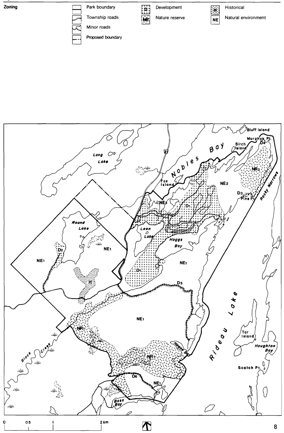
Midway between Kingston and Ottawa on both the Rideau Canal and the Rideau Trail is Murphys Point Provincial Park. Located on the north shore of Big Rideau Lake 19 km south of Perth, it is situated in lake-dotted, rolling, rocky countryside typical of the Frontenac Axis, a southern extension of the Canadian Shield. See Figure 1. The park’s 1239 ha feature three small enclosed lakes or bays, part of the shoreline of another landlocked lake, as well as 11 km of rugged, island-studded lakeshore including the peninsula for which the park is named.
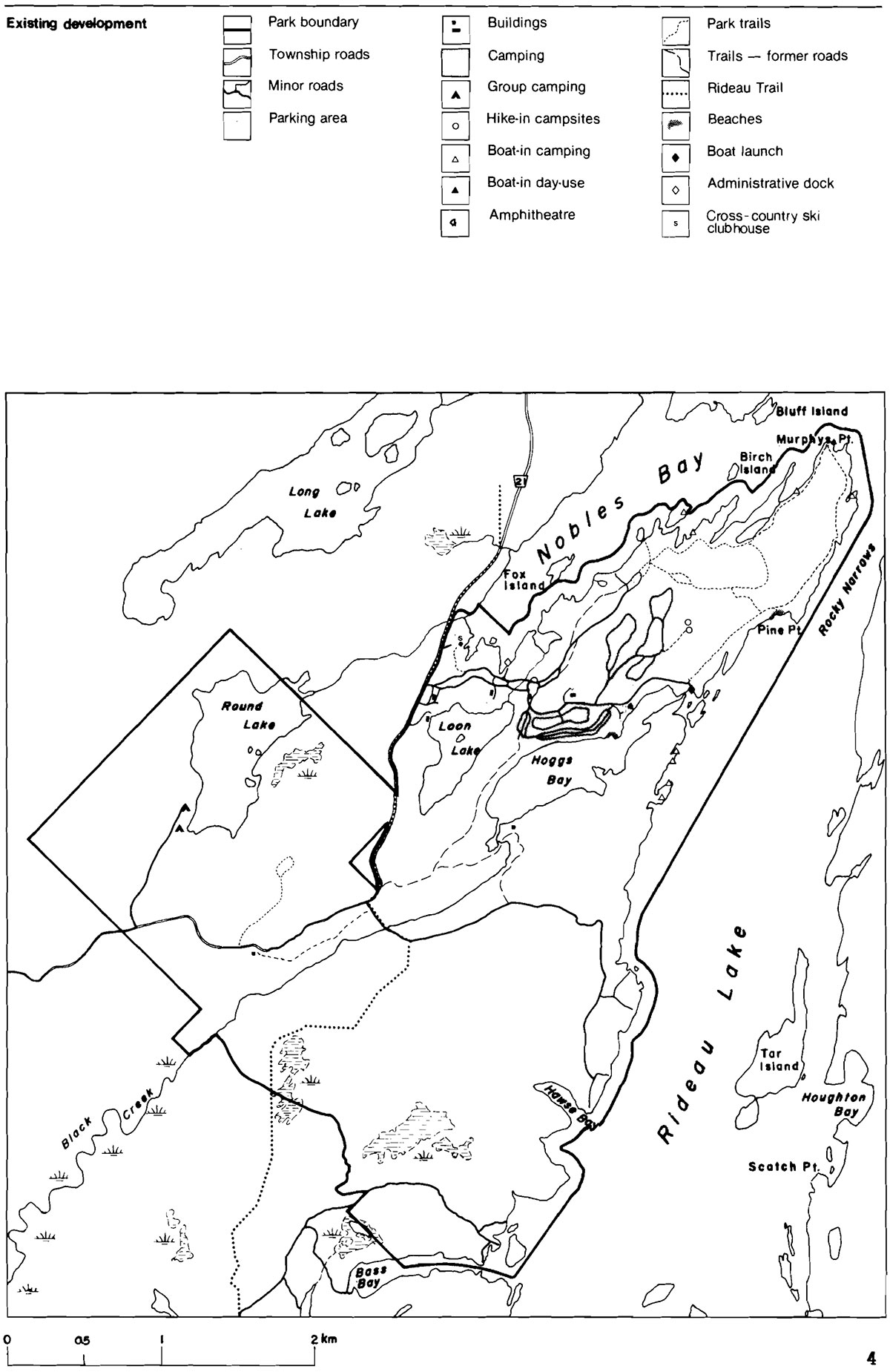
The park contains biological and geological features representative of the Frontenac Axis. The rare black rat snake native to the park is of provincial significance and several plant associations, including representative mixed and coniferous forest stands and hardwood swamps, are of regional significance. The park has a mosaic of vegetation types ranging from forest to old field which have arisen in response to settlement activities, topography and imperfect drainage. Significant features are illustrated in Figure 3.
Cultural and geological features are related in the park. The availability of the Rideau Canal as a commercial waterway was a factor in the establishment of former small scale mining in the park. Abandoned mica, apatite and feldspar mines provide an excellent geological interpretive capability. The old field pattern is also largely determined by bedrock factors; two log cabins, and the remains of a mill are other historical remnants of settlement.
The Ministry of Natural Resources (MNR) officially opened the park in 1979. The point area has long been popular with local residents and boaters; campgrounds in the park were operated for several seasons before it officially opened. Presently, visitors can enjoy 174 car campsites, 6 walk-in sites, a group campground, two day use beaches and a separate campers' beach, a boat launch and an amphitheater. Twelve boat-in sites are available on Rideau Lake. Hiking and interpretive trails link with the Rideau Trail which passes through the park. A network of ski trails is maintained in winter. See Figure 2.
The potential market area for the park reaches from Peterborough, almost to Montreal. However, residents of Ottawa have been the primary users to date, especially for car camping. Park use has steadily increased since its opening, from 15,946 visitors in 1979 to 34,375 in 1983 indicating a continued demand for both camping and day use.
The rocky shoreline of the park severely limits opportunities for extensive beaches or picnic grounds. Although increased camping can be accommodated in limited areas, analysis indicates most of the land base is best suited for extensive forms of recreation, such as hiking. For more information on resource characteristics and development suitability, refer to Bibliography items 7, 10 and 13.
1.1 Issues
During the early stages of management planning and public input, the issue of extent of development was dealt with by choosing a moderate course of development that recognized constraints and respected the existing natural and scenic values of the Rideau Lake area by retaining natural shoreline, wherever possible.
Figure 1: Park Location
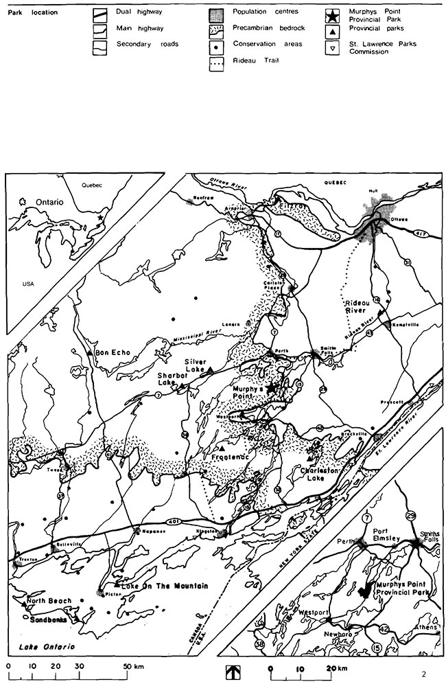
Enlarge Figure 1: Park Location
Demand for day use beach opportunities is straining the present facilities at the park, especially with increased use by boaters. Opportunities for further such use are severely constrained by the rocky shoreline.
Use of the day use facilities by boaters presently generates few fees to offset operational costs. Also, MNR fees for boat-in sites are higher than those charged by Parks Canada for similar facilities elsewhere on Rideau Lake. This creates further problems in collecting fees.
To protect environmental values, reduce management problems and allow trail connections, the park’s land base in the area of Round Lake requires expansion. Part of this area has already been acquired.
2.0 Park policies
2.1 Classification
Distinctive recreation experiences and park environments are provided through six classes of parks. …Natural Environment Parks incorporate outstanding recreational landscapes with representative natural features and historical resources to provide high quality recreational and educational experiences." [18]
Murphys Point is classified as a natural environment park in recognition of its biological, geological and cultural features representative of the Frontenac Axis, as well as the provincially significant black rat snake and regionally significant plant associations. In addition, the park can provide a range of high quality, low intensity recreation opportunities in a natural setting, and can encourage participation by users from the two linear recreation systems, the Rideau Trail and Rideau Canal, that traverse the park area.
2.2 Park goal
The goal for the park is to provide a wide range of medium to low intensity recreational opportunities which are compatible with the environment, and to protect and interpret the environment so as to encourage in users an attitude of custodial responsibility towards resources.
2.3 Objectives
The objectives of the Ontario Provincial Parks System are protection, recreation, heritage appreciation and tourism. Murphys Point contributes to all four of these objectives as follows.
2.3.1 Protection
- To protect provincially significant elements of the natural and cultural landscape of Ontario
Two nature reserve zones and one historical zone are designated to protect significant natural and cultural features. Additional research will determine the practicality of a zone to protect black rat snake habitat, as well as assess other techniques for protection.
2.3.2 Recreation
- To provide provincial park day use and facility-based camping opportunities in an attractive setting
Park use areas have been well-spaced on pockets of developable land, focusing on the internal waters, which has left the Rideau Lake shore in a natural condition. Swimming, hiking, boating, fishing and cross-country skiing are all provided for, as well as camping and picnicking.
Figure 2: Existing development
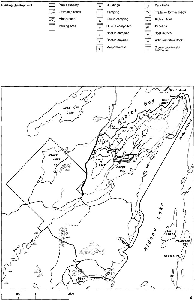
Enlarge Figure 2: Existing development
Murphys Point Provincial Park annually provides recreational opportunities as follows. (Shown in brackets is % of Carleton Place District supply.)
| swimming | 6422 | (10%) |
|---|---|---|
| Picnicking | 14,488 | (8%) |
| Camping | 48,412 | (24%) |
2.3.3 Heritage appreciation
- To provide opportunities for exploration and appreciation of the outdoor natural and cultural heritage of Ontario
There are now two interpretive trails in the park, one each for cultural and natural features. Both types of interpretation will be expanded upon, the cultural one meshing well with the local emphasis on historical and architectural heritage.
Information provided through the visitor services program will enhance individual appreciation of resources along other park trails, and in the surrounding area.
2.3.4 Tourism
- To provide Ontario residents and visitors from outside the province opportunities to discover and experience the distinctive regions of the province
Because of the park’s location on the Rideau Canal and the Rideau Trail, lakeshore areas for boat-in and hike-in camping and day use have been selected, and an extensive park trail system will link with the Rideau Trail. Efforts to promote the park will, wherever feasible, be in concert with those of local agencies.
2.4 Park boundary
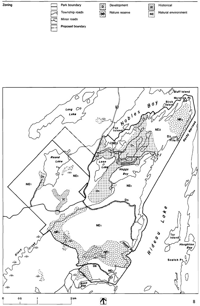
The park boundary will be extended over time, as shown on Figure 4, as properties and funds become available in order to protect environmental values, reduce management problems and allow trail connections. The proposed 70.0 ha addition is that part of Lot 11, Concession V north of Lally’s Lane (County Road 21).
2.5 Zoning
The park is divided into four types of zones to rationalize future use and management: development, natural environment, nature reserve, and historical. See Figure 4. Each zone has separate functions and management approaches. In general, management within zones will be in keeping with the ministry’s planning and management policies, while particular considerations are noted below. Specific details regarding zone boundaries and management concerns are described in Bibliography item 13.
2.5.1 Development zones
Six development zones are designated to provide relatively intensively developed and managed areas associated with recreational activities. Several are relatively small areas, destined for lakeshore and hiking activities or access. Management in general will be directed to providing a variety of day use and extended use opportunities, in keeping with the park’s classification.
Development zone D1 (151.7 ha) includes the existing road network, offices, central washrooms, staff quarters, maintenance and service facilities, two campgrounds with a total of 174 campsites, as well as separate campers' and day users' beaches. This zone extends into the water at beach areas. It includes the restored McParlan log home. It also provides for a future campground of approximately 100 drive-in and walk-in campsites with its own beach. This will be constructed only when local or regional demands warrant and will respect the historic values associated with the McParlan site.
Figure 3: Significant areas
Enlarge Figure 3: Significant areas
Development zone D2 (8.0 ha) is adjacent to Round Lake, with an extension to County Road 21. It will accommodate organized group camping in three sites, each with limited facilities. A small beach will be sited on the lakeshore. Level areas as open as necessary will be maintained, along with vault toilets, parking areas and water supply.
The day use area taking advantage of the best natural beach in the park, forms Zone 03 (1.0 ha). With trail connections to the central camping area and the day use area, it accommodates picnicking and bathing.
Zone D4 (0.5 ha) covers a boat-in picnic site on Murphys Point. Minimal sanitary facilities and dockage will be provided. Natural vegetation will be preserved; no unnatural materials will be used so as to protect aesthetic values at this traditionally popular site.
The last two development Zones 05 (6.0 ha) and D6 (2.0 ha) , follow the routes of cottage access roads, which also act as hiking trails. Maintenance will be limited to that required to provide safe seasonal access, with repairs and mechanical roadside vegetation management performed as necessary. Ministry maintenance in Zone D6 will be limited to that necessary for access to the proposed Bass Bay boat-in area.
2.5.2 Historical zone (14.0 ha)
This linear zone south of Round Lake covers the sites of two former small scale mica, feldspar and apatite mines, as well as an existing interpretive trail linking them to County Road 21. The historical remains which include hand-dug pits, machinery, dumps, and derelict buildings, provide an excellent opportunity for interpretation of typical south shield mining.
Public access will be by foot, along the self-use trail. Period equipment, lookout platforms and reconstructed buildings, will be added to the site, as funding permits. Rustic materials and techniques will be used to recreate appearances of the turn-of-the-century operating period.
The site of the Lally homestead forms a 0.9 ha extension of this zone south of Lally Lane (County Road 21). It will act as a trail staging area with parking, especially for the adjacent interpretive trail to the mines. The values representative of small scale south shield farming (restored Lally homestead, stabilized foundations, stone and rail fencelines, field and successional patterns) will be interpreted in a fashion complementary to the trail. Fencelines and the immediate field pattern will be maintained.
2.5.3 Natural environment zones
These three zones form the largest part of the park, surrounding the development and historical zones, and acting as a buffer to nature reserve zones. Management practices will be directed toward the maintenance of a natural environment which provides a setting for less intensive recreational activities, notably non-mechanized trail use and boat-in camping.
Natural Environment Zone NE1 (886.5 ha) covers most of the western and southern parts of the park, including part of Black Creek and the mature forest area south of Hoggs Bay. It includes most of the waters of Round and Loon Lakes, and Hoggs Bay. It will contain a trail system linked with the Rideau Trail including interpretive trails accessible from the campgrounds, as well as longer routes to shoreline viewpoints and natural areas. Locations for additional boat-in sites and sites for hike-in use only have been selected. In cooperation with The Rideau Trail Association a new route for the Rideau Trail will be laid out in this zone. The proposed 70.0 ha addition to the park falls into this zone.
Figure 4: Zoning
Zone NE2 (40.5 ha) runs across Murphys Point, and around the end of the point. This zone is traversed by trails connecting beaches and campground, as well as hiking, interpretive and skiing routes. Trail siting will respect the limitations of the several bottomland forest areas and dry rocky sites in this zone. Locations for an additional 9 boat-in sites (three also reached by trail) have been identified along Nobles Bay.
Zone NE3 (32.5 ha) covers the shoreline at the end of Nobles Bay, and acts as a buffer to the development zone inland. It also affords protection to other areas of bottomland forest.
2.5.4 Nature reserve zone
Two nature reserve zones protect several areas of biological and geological significance. Management will be minimal, being directed towards protecting and encouraging natural vegetation communities and systems, while offering limited interpretation by trails.
Nature Reserve zone NRl (135.3 ha) has three sections. The first is a rich wetland complex along Black Creek, with excellent examples of vegetative zonation. A highly representative cross section of the park’s typical Canadian Shield geology forms the second section parallel to the park boundary. A relatively mature forest area elevated above the lake, as well as areas of rich bottomland forest and a chain of beaver floods with unusual vegetation, make up the third. Both an interpretive trail and a section of the Rideau Trail passing through the one will be carefully sited.
Zone NR2 (42.0 ha) on the point covers a bottomland forest area supporting a wide variety of ferns, and a relatively undisturbed mixed forest representative of the Great Lakes/St. Lawrence Forest Region. A well marked peripheral trail extends to Murphys Point.
A future nature reserve zone may be defined to protect black rat snake habitat, if it can be determined that the snake has a geographically limited habitat. Adequate information is not presently available to designate such a zone.
3.0 Resource management
3.1 Water
The quality of drinking water and water at the beaches is routinely sampled and checked according to standard park operating procedures.
The use of power boats is prohibited on all inland waters within the park. This includes Loon Lake, Hoggs Bay, and Black Creek.
3.2 Vegetation
Natural vegetation may be manipulated in order to meet recreational goals, or where there is a threat to safety or property. Outside development zones, this will normally be limited to trail or of natural conditions.
Large mown areas will be maintained only at use areas such as beaches or group camping areas. Fields along the trail in the historical zone may be mowed and other clearing done to retain openings as required for interpretation.
Planting will be limited to indigenous native species. Weed control through mowing or buffer planting may be needed to reduce conflict with adjacent landowners. Routine spraying to control poison ivy is permitted only in Zone D1.
Wild fires will be suppressed in keeping with provincial fire management policies. Insect infestations or disease will normally be tolerated and may be controlled, if feasible, in Development and Natural Environment Zones, when private land or values of the zone are threatened.
A vegetation management plan will be prepared for the Development Zones and the Lally homestead part of the Historical Zone. The objectives of this plan will be to retain the original farmstead character of these areas, providing an interesting and enjoyable recreational atmosphere. It will deal primarily with regular mowing, as well as methods to maintain old field openings in Fallows campground, and field patterns around the Lally homestead. Also, control of poison ivy, tree removal and fire fighting strategy will be addressed. A long term tree planting program may be developed in cooperation with the Regional Landscape Architect, but no large scale reforestation will be initiated. Necessary overlap with wildlife management, if any, will be incorporated.
3.3 Wildlife
Hunting and trapping and frog harvesting are prohibited within the park. Control of problem animals identified by the park superintendent may be carried out under the provisions of a wildlife management plan to be prepared for the park. The goal of this plan will be to retain natural species diversity and habitat while providing opportunities for compatible recreational activities in a natural environment.
An active program will be conducted to acquaint staff and visitors with the need to protect the black rat snake. Further research is needed to locate concentrations of this snake, determine its habits, habitat preference, movement patterns and life history. Such research will determine the feasibility and specifics of a protective zone. The Wildlife Management Plan could also address protection of the black rat snake once information on the species is obtained.
Patterns of beaver activity in Zone NR1 will not be disrupted, so as to maintain the wetland ecosystems and characteristic successional patterns. The need and methods to increase wildlife viewing along trails which may include minor habitat manipulation will be investigated.
3.4 Fish
Sport fishing will be encouraged for a variety of species. For this reason, district staff will assess Loon Lake for its potential for recreational fishing.
If necessary, special protection will be given to the mouth of Black Creek during the annual pickerel spawning period.
3.5 Aesthetics
Within the park and along County Road 21, existing traditional rail fencing will be maintained to continue the historical rural character. Areas offering scenic views from and over the water have been identified and will be protected. All shoreline development will be as natural as possible.
In siting buildings, facilities and surrounding plantings, an attempt will be made to recreate or reinforce the natural landscape.
3.6 Cultural resources
A cultural resources management plan will be prepared. Its purpose is to ensure the preservation and interpretation of the historical resources in the park through wise management, use and maintenance. The three major cultural sites will be addressed in this plan. Management objectives for the Lally and McParlan homesteads and the mine site are to maintain and preserve these features while providing opportunities for self-guided exploration and appreciation. The plan will address maintenance methods, interpretive facilities and may include site plans.
Research into the park’s history and cultural resources should continue, focusing on the three sites and their thematic links. Artifacts found will be catalogued and consideration given to display, restoration, and storage. Where major developments are proposed, such as camping areas, archeological surveys will be carried out to guard against possible damage to unknown sites.
4.0 Client services
4.1 Visitor services
The park will have a seasonal activity program, plus year-round self-use interpretive facilities. Emphasis will be on generating a mood of discovery in visitors.
Communication of park and area information will be effected by all staff, by notice boards and, in particular, by specific and seasonal trail guides, a newsletter, boaters' guide and other feature publications. Visitor reaction will be solicited by staff.
Interpretation will focus on the historical themes of south shield small scale mining and agriculture, as affected by Precambrian bedrock geology. Although these themes are shared with other parks, this one has the most accessible resources. Minor themes are those of Frontenac Axis ecology, the Rideau Canal, and local architecture. Liaison with other agencies will focus on thematic links, particularly the Rideau Canal operated by Parks Canada and the historical restoration work at Perth. Interpretation will be primarily through self-guiding trails and cultural sites complemented by amphitheater programs. An emphasis will be placed on transmitting the concept of custodial responsibility for resources to park users.
Outdoor recreation will be fostered through the provision of facilities and opportunities for a variety of year-round non-motorized activities. To supplement this, special recreational events or skill training sessions in cooperation with other agencies or clubs, will be promoted or sponsored. No organized programs or activities will be provided.
Figure 5: Proposed Development
Enlarge Figure 5: Proposed Development
For Outdoors education purposes, the park’s resources will be available for use by school groups within policy and protection guidelines. Resource information will be provided to teachers and leaders of groups. Priority will be given to studies promoting discovery, involving the acquisition of non-destructive outdoor skills and enhancing environmental or cultural awareness.
A visitor services plan will be prepared at the park to guide the orderly provision of the services noted. It will be in keeping with the regional visitor services plan. The existing marketing plan for the park will be updated and revised to emphasize camping rather than beach use.
5.0 Proposed development
Further development and improvement will proceed according to Figure 5, these guidelines and appropriate site plans.
5.1 Campgrounds
An area suitable for additional camping has been located at the western end of Loon Lake. Approximately 100 campsites, including a dozen walk-in sites as well as a beach, can be accommodated. This expansion will take place only when local or regional demand warrants, and as funding priorities permit.
The Carleton Place District Land use Guidelines indicate no shortage of camping opportunities for the district at present.
Locations for additional shoreline boat-in (15) and hike-in (6) sites have also been selected. The hike-in sites will be developed in conjunction with the completion of the shoreline loop of the Rideau Trail. Further boat-in site development will depend on demand, as well as resolution of fee collection problems.
5.2 Trails
The use of snowmobiles and other off-road all-terrain vehicles is prohibited within the park. Other motor vehicles and bicycles are restricted to park roads.
The trail system, when completed, will offer 6.3 km of interpretive trails, and 20.5 km of hiking trails, including a 3.2 km shoreline loop for the Rideau Trail. At least one interpretive trail will accommodate handicapped users. Hiking trails will be laid out to accommodate skiing, wherever possible, with the assistance of the appropriate clubs.
Trail staging points at the Lally and McParlan sites will provide maps and simple shelter.
After existing interpretive trails are completed, priority for new development will be given to the Hoggs Bay triangle route, the Black Creek trail, and then the former road which parallels Nobles Bay. Following that, southern trails and Round Lake routes will be done. Ski trails will be operated each winter on park roads and trails, under agreement with the Tay Valley Cross Country Ski Club.
5.3 Beaches
The present day use beach on Nobles Bay will be extended on its western side. Control of boat docking and mooring will be required, and appropriate fees charged when practical. The adjacent area near the proposed boat launch will be investigated for its potential to relieve day use pressure. Boat launch development may be deferred.
5.4 Group camping
A small beach will be created on the shore of Round Lake. A third site to hold 50 campers has been selected, and will be developed in response to demand.
5.5 Visitor services facilities
Priority will be given to completion and maintenance of self-guiding facilities. This includes the heritage building sites. Their use for displays or more complex trail staging sites will be investigated. The addition of period equipment, lookout platforms and reconstructed buildings to the mines site, as funding and availability permits, will also require imaginative interpretation.
5.6 Access, circulation and administration
The present circulation system performs adequately during the peak summer season. A short segment of closed road near the permit office will be graded and planted. The day use road will be realigned at the former day use office site. Laneways to and in the future camping area will be maintained as trails.
In Zone D1, a network of foot trails will connect use areas, main facilities and other zones, providing an alternative to driving.
In the winter, skiing access and parking will be from the former storage yard off County Road 21 at the park entrance. Park roads will not be plowed, but used in part as ski routes. Ski shelters will be maintained in cooperation with the Tay Valley Cross Country Ski Club of Perth.
6.0 Implementation strategy
The following projects will be implemented with approval of this management plan. Those completed will depend on Ministry of Natural Resources priorities for capital funding. The management plan will be reviewed as the need arises.
6.1 Phasing
Phase I
- Mine site interpretive trail, 1.2 km
- Hoggs Bay triangle route hiking trails, 8 km
- McFarlan and Lally trail staging areas
- Day use beach and mooring
- Boat-in picnic site
- Cultural resources management plan
- Visitor servicesmanagement plan
- Wildlife management plan
Phase II
- Black Creek interpretive trail, 2 km
- Mines buildings reconstruction
- Day use beach or boat launch
- Boat-in campsites, 12
Phase III
- Nobles Bay interpretive trail accessible to handicapped, 1 km
- South hiking trails, 8 km
- Hawse Bay and Black Creek hike-in campsites, 10
- Group campground beach
- Vegetation management plan for Development zones and part of Historical Zone
Phase IV
- Boat-in campsites, 11
footnote 1 - Round Lake hiking trail, 4.5 km
footnote 2 - Third group campground site
6.2 On-going projects
The acquisition of period artifacts for the mine site and their placement on the site will be an on-going process, as availability and funding permit. The relocation of the Rideau Trail route through the park similarity will depend on The Rideau Trail Association’s priorities and progress in areas beyond the park.
Holdings within the park boundaries will be acquired only from willing vendors, as they become available. This will ease management and ensure consistency of environmental values.
7.0 Summary of public consultation
After the initial stages of resource data collection were complete, the planning team began a public consultation program. This program had several objectives: to inform interested individuals and groups of the natural features and constraints of the park area, to introduce the provincial park planning process to the public, to ensure public input into the planning process, so that needs of local, as well as province-wide groups or individuals, would be reflected in the plan, to provide additional cultural or natural data to the planning team, and to allow mutual education of the public and the planning team.
The program was initiated using newspaper and radio notices of the availability of information packages. Advertisements were placed locally, as well as in Kingston and Ottawa. Each package contained an outline of the park resources, the planning process and a comment sheet. These were also sent to groups and individuals known to be interested in the park’s planning. In total, 350 packages were distributed.
Public meetings were subsequently held in Perth and Smiths Falls at which park resources were described and local desires discussed. overdevelopment and pollution were concerns. Commitment to a low development intensity natural environment park was expressed. Almost 100 written responses were received.
A majority of responses favoured preservation of the natural, quiet character of Murphys Point and development which would encourage physical participation in an outdoor environment. A news release summarizing the responses was widely distributed. A meeting was held at the park, with members of a local cottagers' organization. using the responses to the information packages and meetings, the planning proceeded with the formulation of clearer goals and objectives and preparation of concept alternatives for park development.
Three development concept alternatives, as well as a summary of comments received were presented at a second set of meetings. An updated information brochure was distributed at these well advertised meetings. Response was favourable. The lowest density development concept was deemed the most suitable by those attending meetings.
After this initial public consultation, information was updated by means of comment cards and user surveys and the park’s role and contribution to parks systems planning targets was confirmed during district land use planning. Subsequent internal reviews and refinement of planning policies resulting in this management plan have attended to the concerns raised during public consultation.
Bibliography
1. Argus, G. w. and D.J.White. The Rare vascular Plants of Ontario. syllogeus No.14. Ottawa: National Museums of Canada, 1977.
2. Bell, G. P. A Comparative . Biology of Three Provincial Parks in Southeastern Ontario. Kemptville: Ontario Ministry of Natural Resources, 1977.
3. Burton, T. Murphys Point Provincial Park: Ecological Inventory. Toronto: Department of Lands and Forests, 1970.
4. Cameron, M. and S. McLaren. Boating Survey: Narrows Lock and Poonamalie Lock. Lanark District: Ontario Ministry of Natural Resources, 1975.
5. Canada/Ontario Rideau/Trent Study (CORTS) Committee. Yesterday, Today, Tomorrow: Rideau/Trent/Severn. Toronto: Queen’s Publisher, 880 Bay Street, 1973.
6. Chapman, L. J. and D. F. Putnam. The Physiography of southern Ontario. Second edition, Toronto: University of Toronto Press, 1966.
7. Clement, S. Brief Geomorphology and Geology of Murphys Point . Provincial Park. Toronto: Ontario Ministry of Natural Resources, 1974.
8. Froorn, B. The Snakes of Canada. Toronto: McClellaoo and Stewart, 1974.
9. Kessel-Tayler I. Early South Shield Mining: A Review of Apatite, Mica and Feldspar. Kernptville: Ontario Ministry of Natural Resources, 1982.
10. Lindsay, K. A Brief Biological Inventory of Murphys Point Provincial Park Reserve. Toronto: Ontario Ministry of Natural Resources, Park Planning Branch, 1974.
11. Miller, M. Small Scale Mining in the South Shield Region of Eastern Ontario. Kemptville: Ontario Ministry of Natural Resources, 1976.
12. Ontario Ministry of Natural Resources. Charleston Lake Provincial Park Master Plan. Toronto: Ontario Ministry of Natural Resources, 1978.
13. Ontario Ministry of Natural Resources. Murphys Point Provincial Park Background Information Document. Kernptville: Parks and Recreational Areas Branch, 1980.
14. Ontario Ministry of Natural Resources. 1980 Provincial Park Camper Survey Summary Statistical Report. Toronto: Parks and Recreational Areas Branch, 1981.
15. Ontario Ministry of Natural Resources. 1980 Provincial Park Day user Survey Summary Statistical Report. Toronto: Parks and Recreational Areas Branch, 1981.
16. Ontario Ministry of Natural Resources. 1974 Park Day-User survey. Toronto: Division of Parks, 1974.
17. Ontario Ministry of Natural Resources. Ontario Provincial Parks Planning and Management Policies. Toronto: Park Planning Section, 1978.
18. Ontario Ministry of Natural Resources. Ontario Provincial Parks Resources, 1982. Policy. Toronto: 1978.
19. Ontario Ministry of Natural Resources. Silver Lake Provincial Park Campers Survey. Lanark District, Ontario Ministry of Natural Resources, 1975.
20. Ontario Ministry of Treasury, Economics and Intergovernmental Affairs. Ontario Population Projections to 2001. Toronto: 1974.
21. Regional Municipality of Ottawa-carleton, Regional Planning Department. Official Plan, Ottawa-Carleton Planning Area. Ottawa: Regional Council, 1974.
22. Rowe, J. S. Forest Regions of Canada. Publication Number 1300, Ottawa: Department of the Environment, Canadian Forestry Service, 1972.
23. Sasaki, Strong and Associates, Ltd. Murphys Point Provincial Park: Project Survey Memorandum. Toronto: Department of Lands and Forests, Parks Branch, 1966.
24. Swayze,K. Archaeological Inventory of Murphys Point Provincial Park and the Mouth of the Tay. Toronto: Ontario Ministry of Natural Resources, 1975.
25. Thomas, E. Resource Inventory Report: A Faunal Inventory of Murphys Point Provincial Park. Toronto: Ontario Ministry of Natural Resources, 1974.
26. Tourism and Outdoor Recreation Planning Study Committee. Tourism and Recreational Behaviour of Ontario Residents, Volumes 1 to 8. Toronto: Queen’s Park, 1977.
27. Van Haaften, S. Earth Science Inventory Checklist (and report) Murphys Point Provincial Park. Kemptville: Ontario Ministry of Natural Resources, 1979.
28. van Haaften, S. and A. McKay. Murphys Point Provincial Park Bedrock Geology (map). Kemptville: Ontario Ministry of Natural Resources, 1978.
29. Weiler, J. Preliminary Report: Historical Resource Inventory, Murphys Point Provincial Park. Kemptville: Ontario Ministry of Natural Resources, 1975.
Footnotes
- footnote[1] Back to paragraph Requires resolution of fee rate and means of collection
- footnote[2] Back to paragraph Requires land acquisition.