Noganosh Lake Provincial Park Management Statement
This document provides policy direction for the protection, development and management of Noganosh Lake Provincial Park and its resources.
Interim Management Statement
March 1, 2004
The Noganosh Lake Provincial Park Interim Management Statement provides direction for the custodial management of Noganosh Lake Provincial Park until such time as a Park Management Plan may be prepared. An Interim Management Statement, by design, is primarily an internal document intended to provide short-term guidance for Ontario Parks' managers and staff. The Interim Management Statement will govern all activities occurring within the park and focus on custodial management required to protect park values and ensure public health and safety.
The Interim Management Statement was first prepared in January 2002. Since that time, the park boundary has been regulated, new information on cultural resources has been collected, and there have been changes to some land use policies. The revised Interim Management Statement reflects these developments and replaces the earlier version.
Questions or requests for additional copies of this document should be directed to:
Ontario Parks, Central Zone
RR #3, 451 Arrowhead Park Road
Huntsville, ON P1H 2J4
I am pleased to approve the Noganosh Lake Provincial Park Interim Management Statement.
Original signed by:
Brian Pfrimmer, Manager
Central Zone
Ontario Parks
Background information
| Name | Noganosh Lake Provincial Park |
|---|---|
| Classification | Waterway |
| Ecoregion / ecodistrict | 5E / 5E-5 and 5E-7 |
| OMNR administrative region / district | Southern Region / Parry Sound District |
| Total area (ha) | 3,082 |
| Regulation date | June 28, 2003 |
Inventories
| Survey level | Earth science | Life science | Cultural | Recreational | Other |
|---|---|---|---|---|---|
| Check Sheets / Inventories | 2002 | ||||
| Reconnaissance | 2003 | ||||
| Detailed | 2002 | 2002 | 2002 |
| Earth science representation | The bedrock of Noganosh Lake Provincial Park is within the east central part of the Britt Domain, Algonquin Terrain of the Central Gneiss Belt, in the Proterozoic Grenville Province. The dominant rock types of the park are highly deformed quartzofeldspathic and hornblende-magnetite gneisses. |
|---|---|
| Life science representation | Recent surveys have identified approximately 300 vascular plant species and approximately 17 forest Ecosite Types within the park. Most communities are in excellent condition. Seventeen species of reptiles and herptiles, 82 species of birds and at least 11 species of mammals were documented in the park. |
| Cultural resources representation | The region in which the park is situated is of historical importance to both First Nations and European settlers. The area has traditionally supported hunting, fishing and trapping. Logging has also figured prominently in the regions history. A reconnaissance inventory has revealed that there is a high potential for sites of archaeological significance from both the pre- and post- contact periods. |
| Recreational opportunities | Boating, Canoeing, Camping, Kayaking, Hiking, Swimming, Hunting, Fishing, Nature Appreciation |
1.0 Introduction
On July 16, 1999, the Ontario Government released the Ontario’s Living Legacy Land Use Strategy to guide the planning and management of Crown lands in central and parts of northern Ontario. A major part of the Land Use Strategy was a government commitment to protect 12 percent of Ontario’s Crown lands and waters within the planning area of the strategy. Noganosh Lake Provincial Park is part of this significant expansion of Ontario’s protected areas system.
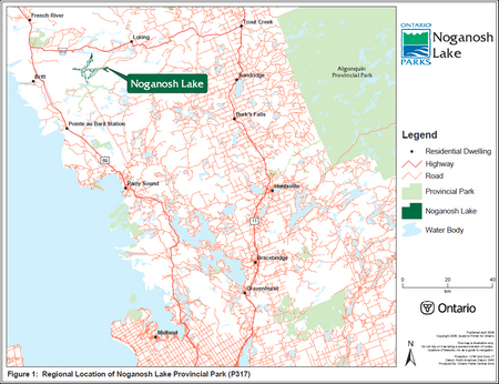
Noganosh Lake Provincial Park is principally located in Brown Township, Parry Sound District (Figures 1 and 2). The extreme western, eastern and northern ends of the park extend into Wallbridge, Wilson and Blair Townships respectfully. The park runs through Ecodistricts 5E-5 and 5E-7. Numerous regionally or provincially rare species of plants, including plants with Atlantic Coastal Plain affinities and one provincially rare species of reptile, have been documented in the park to date. Noganosh Lake Provincial Park provides ample opportunities for recreation, including canoeing, fishing, swimming and hiking. The land-based portions of the park are also part of a traditional hunting area.
2.0 Classification
Noganosh Lake Provincial Park is classified as a Waterway class provincial park in recognition of its representative natural features and historical resources. It is also recognized that this outstanding recreational water route can provide high quality recreational and educational experiences.
3.0 Boundary
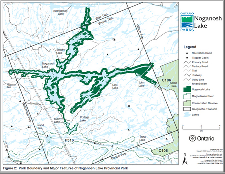
Noganosh Lake Provincial Park runs from the western part of Wilson Township following the watercourse of Noganosh, Last, Mud and Smoky Lakes. The boundary of the park (Figure 2) includes shore lands on both sides of the watercourse, the waters, the riverbed and the Crown islands between these shores. The Crown shore lands extend 60 metres from the waters edge around Portage Lake, Sunny Lake, and from the portage between Noganosh and Sunny Lakes, 120 metres throughout most of the west side of the park, and generally 200 metres elsewhere. Where the park abuts private land, the boundary extends to the waters edge.
The park also includes Smoky Creek, a natural link between the park and the Kawigamog Lake-Pickerel River system to the north. Noganosh Lake Provincial Park borders Magnetawan River Provincial Park to the south and Island Lake Forest and Barrens Conservation Reserve to the east. Most of the lands surrounding the park are within the Parry Sound Interior Remote Access Enhanced Management Area.
Noganosh Lake Provincial Park was regulated on June 28, 2003 under Ontario Regulation No. 238/03 (see Appendix A).
4.0 Interim management guidelines
Management of Noganosh Lake Provincial Park will follow the management policies for Waterway class parks, presented in Ontario Provincial Parks: Planning and Management Policies (1992). Management of the park will also consider the land use direction outlined in the Ontarios Living Legacy Land Use Strategy, including its provisions to respect the existing protective and restricted access measures defined for the Noganosh region in the MNR Parry Sound District Land Use Guidelines (1983).
In the implementation of the approved Interim Management Statement, Ontario Parks may pursue opportunities for partnerships involving other agencies and groups. Park management and stewardship will be contingent upon availability of funding and unforeseeable changes in priorities or policy. All management and stewardship activities will conform to the Environmental Assessment Act, Provincial Parks Act and other pertinent legislation.
4.1 Natural resource stewardship
The protection of provincially significant, special or representative life and earth science features will be a high priority for Noganosh Lake Provincial Park.
Management of the area will allow natural processes to continue to shape the ecology of the parks aquatic and terrestrial environments. A resource stewardship plan may be considered should more detailed management direction be required for resource or heritage values of particular concern.
All fires will be suppressed. Fire management through prescribed burning will not be considered at this time.
Figure 1: Regional Location of Noganosh Lake Provincial Park (P317)
Enlarge Figure 1: Regional Location of Noganosh Lake Provincial Park (P317)
Figure 2: Park Boundary and Major Features of Noganosh Lake Provincial Park
Enlarge Figure 2: Park Boundary and Major Features of Noganosh Lake Provincial Park
4.2 Cultural resources
A reconnaissance cultural resources inventory found that there remains significant potential for the existence of sites of importance within the park for both the pre- and post- contact periods (Carscallen, 2003). Although there is visible evidence of the logging era (1850-1920), the archaeology of the Noganosh region is generally poorly understood. Further study will be encouraged. Sites identified for physical improvements in future management planning processes will be inspected for the presence of cultural resources prior to development.
4.3 Recreational activities
As noted in the Ontario’s Living Legacy Land Use Strategy, angling and hunting occurring within the park boundary will be permitted to continue.
Low-impact recreational activities such as hiking, swimming, canoeing, boating, kayaking and nature-appreciation will be permitted.
Most campsites within the park boundary will be permitted on an interim basis until a management plan is prepared. Some sites may be closed if deemed to have a negative impact on the environment and protection objectives of the park. Alternate sites may be provided should the closure of an existing site(s) be required but, overall expansion of camping opportunities will only be considered through a full management planning process.
Through the management planning process, further management prescriptions can be made to minimize user conflicts and maximize user enjoyment. In the interim, any recreational activity found to have a negative impact on the protection objectives of Noganosh Lake Provincial Park will have appropriate actions taken to minimize effects.
Existing authorized trails and portages will remain and may continue to be used. A trail assessment may be completed for Noganosh Lake Provincial Park to review the existing trail structure and to provide appropriate recommendations.
In keeping with the restricted access provisions defined for the region in the MNR Parry Sound District Land Use Guidelines (1983) access to the park will generally be limited to traditional means, namely boat-in, fly-in (Section 4.6), walk-in and ATV/snowmobile use along existing authorized trails. There are no public access roads to the park.
4.4 Land tenure
The park is comprised of only the Crown land and Crown riverbed along the described watercourse (Section 3.0). No private lands are included in the park.
There are six Crown recreation camps within the park, including four Licenses of Occupation (LO) and two Land Use Permits (LUP). There are an additional two recreation camps located on private land, but which are adjacent to or encompassed within the greater park boundary. There is a private commercial outfitter located on a private island on Smoky Lake. Existing recreation camps on Crown land with a LUP or LO will be permitted to continue and may be eligible for enhanced tenure, but not purchase of land.
New Crown land disposition for the private use of individuals are generally not permitted. However, minor dispositions in support of existing uses (e.g. reconstruction of a septic system) will be considered provided that park values are not adversely affected. New dispositions for commercial tourism uses can be considered through a management planning process where consistent with existing policy. New licenses or permits for commercial trapping, fishing, baitfish or wild rice harvesting activities will not be issued.
Hydro One holds a LUP for a transmission line that crosses the park, and is permitted access to conduct necessary maintenance.
4.5 Existing and proposed development
One waterway crossing is located in the park on the Courtney Lake Road at the man-made canal separating Noganosh Lake from Smoky Lake. A short span bridge will be put into place at the existing location as needed for future forest operations and will be removed every summer.
A number of resource access roads cross the park as follows:
- Brown Township Road (major forest access road) at the west end of Noganosh Lake
- Road to the Noganosh dam
- Brown Township Road at the south-western end of Southern Bay
- Courtney Lake Road to Brown Township Road water crossing
- two sections of road on the western side of Smoky Lake
- one section of road on the eastern side of Smoky Lake
All resource access roads in the area are closed to public use. However, recreation camp members and the general public are permitted to travel by ATV along portions of the Brown Township Road and access trail along the Hydro corridor. Travel on the Brown Township Road is controlled by the MNR Parry Sound District office. Those wishing to use the Brown Township Road to access the park, including recreation camp operators should contact the District office for current access regulations and policy.
With the exception of ATV use on portions of the Brown Township Road and hydro corridor trail, Noganosh Lake Provincial Park contains no authorized snowmobile or ATV trails. Off-trail use is prohibited unless authorized by the park superintendent under the authority of OR 587/92 of the Provincial Parks Act. New trails can be considered through a management planning process where consistent with policy and land use direction.
Noganosh Lake dam is situated within the park at the west-end of Noganosh Lake. The MNR maintains the dam and its access road, and will be permitted access to the park for such purposes. A hydro right-of-way under LUP bisects the park east of the dam.
There is no proposed development for Noganosh Lake Provincial Park at this time. However, access points may be considered. A full management planning process will be completed prior to any other future development.
4.6 Commercial activities
Commercial timber harvest, hydroelectric development, mineral exploration and mining are not permitted within Noganosh Lake Provincial Park. Existing authorized commercial activities relating to trapping, baitfish or wild rice harvesting may continue where the activity has been licensed or permitted since January 1, 1992. New operations will not be permitted.
There are parts of nine registered trap lines within the park. These will be permitted to continue indefinitely. New operations including trap line cabins and trails will not be permitted.
Commercial outfitters in the region that have traditionally used the park, including associated facilities, will be allowed to continue subject to management prescriptions determined through management planning. Existing authorized facilities may be eligible for enhance tenure, but not for the purchase of the land. New tourism facilities may be considered through management planning where consistent with existing policy and protection objectives.
Uses in association with fly-in operations will conform to park policies and provincial statutes. At present, aircraft are permitted by regulation to land in only a limited number of provincial parks specified under the Provincial Parks Act. Although Noganosh Lake Provincial Park is not one of the parks identified in the regulations, in keeping with the intent of the Ontario’s Living Legacy Land Use Strategy recreational uses that existed at the time of the parks designation will be permitted to continue. Traditional float plane access will be permitted to continue as a non-conforming' use until such time as landing regulations may be amended, suitable alternate means of access can be provided or uses disappear naturally. Aircraft landings will be reviewed when a park management plan is prepared.
4.7 Aboriginal interests
Noganosh Lake Provincial Park is not subject to any First Nation land claim at this time. Management of the park will not impede the ability of First Nation members to exercise their aboriginal and treaty rights, nor will it interfere with the settlement of any future land claims that may arise.
4.8 Client services
Natural Heritage Education programs and services will not be provided in the interim, but may be considered through the management planning process. Basic information on the park may be provided through Ontario Parks' printed media and web site.
4.9 Research
Specific research by universities and other qualified applicants will be encouraged. All research activities will conform to the Ontario Parks Research and Information Strategy, and Ontario Parks' policies. Prior written permission will be required. All research will be non-intrusive in order to safeguard protection objectives.
Research may deal with all aspects of scientific study, inventory or surveys of vegetation, ecological, cultural, economic and recreational resources and processes.
4.10 Marketing
A marketing strategy is not a priority for the park. A marketing strategy may be considered in the future as the need arises.
5.0 References
Carscallen, C (2003). Stage 1 Cultural Heritage Inventory: Magnetawan River and Noganosh Lake Provincial Parks, AFBY Archaeological & Heritage Consultants.
Frey, E.D., D. Duba (2002). P317 Noganosh Lake Provincial Park Earth Science Reconnaissance Report, Ontario Parks, Central Zone.
Korol, J. Burke (2002). A Detailed Life Science Inventory of Noganosh Lake Provincial Park, Ontario Parks, Central Zone.
Kretschmar, Ulrich (2002). Earth Science Inventory Report for Dalton Digby Wildlands Provincial Park, Magnetawan River Provincial Park, Noganosh Lake Provinical Park, Ontario Parks, Central Zone.
Marzinotto, Erika (2002). Noganosh Lake Provincial Park (P317) Recreation Resource Inventory Report, Ontario Parks, Central Zone.
Ontario Ministry of Natural Resources (1999). Ontario’s Living Legacy Land Use Strategy. Queen’s Printer for Ontario.
Ontario Ministry of Natural Resources (1992). Ontario Provincial Parks Planning and Management Policies, 1992 Update. Parks and Natural Heritage Policy Branch.
Ontario Ministry of Natural Resources (1994). Park Policy, Procedure and Bulletin. "PM 11.02.01, Preparation of Interim Management Statements" Provincial Park Operations Branch.
Ontario Ministry of Natural Resources (1983). Parry Sound District Land Use Guidelines.
Appendix A: Provincial Park and Conservation Reserve ID and Regulation information
| Provincial Park / Conservation Reserve | Ontarios Living Legacy Site # | Crown Land Use Atlas ID | Regulation date | Regulation # |
|---|---|---|---|---|
| Noganosh Lake Provincial Park | P317 | P317 | June 28, 2003 | 238/03 |
| Magnetawan River Provincial Park | P316 | P316 | June 28, 2003 | 238/03 |
| Island Lake Forest and Barrens Conservation Reserve | C106 | C106 | August 10, 2000 | 461/00 |
| Parry Sound Interior Enhanced Management Area | E104A | E104A | N/A | N/A |