Noisy River Provincial Park Management Statement
This document provides direction on the management of Noisy River Provincial Park.
Interim Management Statement
2007
Approval statement
I am pleased to approve this Interim Management Statement for Noisy River Provincial Nature Reserve. Noisy River Provincial Nature Reserve was regulated under the Provincial Parks Act in May of 1989 (O. Reg. 290/89) and is managed as a nature reserve class park.
This Interim Management Statement provides direction for the protection and management of Noisy River Provincial Nature Reserve.
Signed by:
Brian Pfrimmer
Zone Manager
Central Zone, Ontario Parks
Date: August 23, 2007
1.0 Introduction
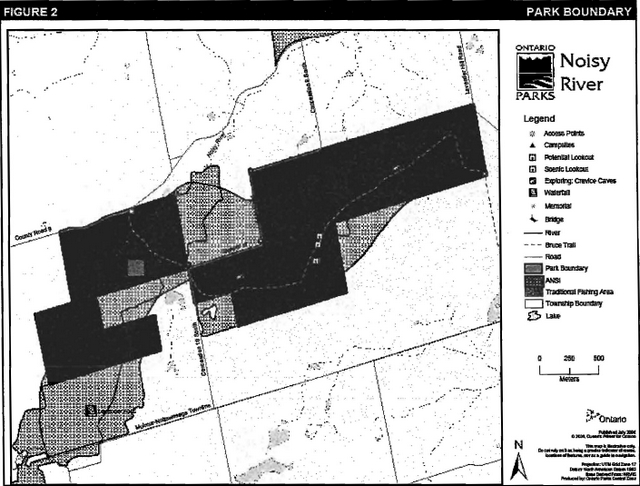
Noisy River Provincial Nature Reserve is located on the Niagara Escarpment, 26 km south of Collingwood (Figure 1). It is located in Ecodistrict 6E7 and contains 378 ha of land regulated under the Provincial Parks Act (O. Reg. 290/89) (Figure 2). The park is part of a glacial re-entrant river valley that was formed during the last ice age. The valley landform includes tablelands with Niagara Escarpment cliff, slope and valley bottomland habitats containing 46 different vegetation types. Noisy River Provincial Nature Reserve is located within the area designated by the Niagara Escarpment Plan (NEP, 2005)
Management of Noisy River Provincial Nature Reserve has been guided by an Interim Management Statement (IMS) written in 1985 and entitled Lavender Falls Candidate Provincial Park Interim Management Statement. This IMS has been rewritten to correct the name of the report, add the regulated status of the park, and to update information from recent reports (e.g. life science and recreation inventories).
The IMS will provide direction to ensure custodial management of park resources. Any significant decisions regarding resource stewardship, development, operations, and permitted uses will require Ontario Parks to conduct a further planning process, including public consultation.
Noisy River Provincial Nature Reserve is managed under the Wasaga Beach cluster of parks.
2.0 Classification
Ontario Provincial Parks are classified into one of six categories, each of which has particular purposes and characteristics.
Noisy River is a nature reserve class park. The emphasis of nature reserve parks is on providing representation of and protection to Ontario’s geological, ecological and species diversity. Where compatible with park values, low intensity day-use activities are encouraged. The park’s landform features provide a variety of recreation opportunities including: nature appreciation, hiking/backpacking, landscape and wildlife viewing, skiing, snowshoeing, exploring, and picnicking.
The park is also classified by the NEP as a Nature Reserve within the Niagara Escarpment Parks and Open Space System (NEPOSS).
3.0 Objectives
Management of Noisy River Provincial Nature Reserve will be consistent with the four objectives for provincial parks, as described in the Provincial Parks and Conservation Reserves Act, 2006 (effective September 4, 2007):
- To permanently protect representative ecosystems, biodiversity and provincially significant elements of Ontario’s natural and cultural heritage and to manage these areas to ensure that ecological integrity is maintained
- To provide opportunities for ecologically sustain able outdoor recreation opportunities and encourage associated economic benefits
- To provide opportunities for residents of Ontario and visitors to increase their knowledge and appreciation of Ontario’s natural and cultural heritage
- To facilitate scientific research and to provide points of reference to support monitoring of eco-logical change on the broader landscape
Figure 1: Regional Setting
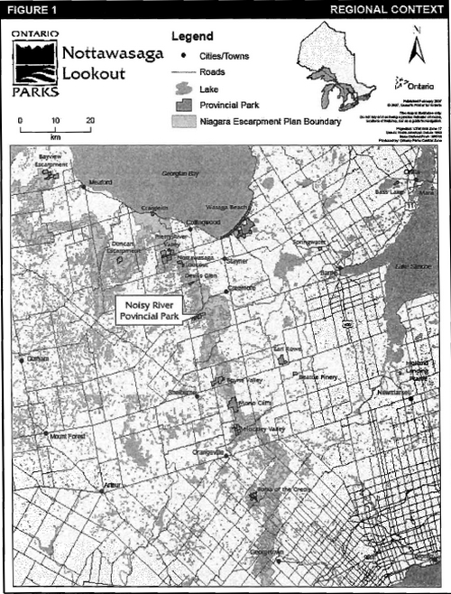
Figure 2: Park Boundary
4.0 Management context
Park management will follow direction from the:
- Ontario Provincial Parks Planning and Management Policies and updates
- Provincial Parks and Conservation Reserves Act, 2006 (PPCRA) and regulations (effective September 4, 2007).
Ontario Parks will also act in accordance with the Niagara Escarpment Plan (NEC, 2005) and the Niagara Escarpment Planning and Development Act (NEPDA, Chapter N.2, R.S.O. 1990) when making planning decisions affecting the park. Part 3 of that plan includes objectives and policies for a Niagara Escarpment Parks and Open Space System (NEPOSS) as a framework for the establishment and coordination of a system of publicly owned lands on the escarpment as well as the Bruce Trail (NEC, 2005). Lands are managed by various public bodies including Ontario Parks, the Ontario Ministry of Natural Resources (MNR), Conservation Authorities, Parks Canada Agency and others. NEPOSS protects the significant natural and cultural features along the escarpment, and provides opportunities for recreation and public access. The PPCRA requires that a Park Management Plan be developed for all Provincial Parks. The NEP also requires that management plans be developed for all parks which fall within the NEPOSS.
The NEPOSS sets out a series of objectives for parks and public lands that fall within its jurisdiction. Management of the Noisy River Provincial Nature Reserve will contribute to several of these, including:
- To protect unique ecological and historical areas
- To complete a public system of major parks and open space through additional land acquisition and park and open space planning
- To maintain and enhance the natural environment of the Niagara Escarpment
- To provide a common understanding and appreciation of the Niagara Escarpment
- To show leadership in supporting and promoting the principles of the Niagara Escarpment’s World Biosphere Reserve designation through sustainable park planning, ecological management, community involvement, environmental monitoring, research and education
In 1990, the United Nations Educational, Scientific and Cultural Organization (UNESCO) designated the Niagara Escarpment as a World Biosphere Reserve in recognition of its natural heritage significance, and to recognize and endorse the Niagara Escarpment Plan. The Niagara Escarpment Plan was Canada’s first large-scale environmental land use plan, which uses policies to ensure the escarpment remains a sustainable natural environment for future generations.
When addressing custodial management to protect park features and values and ensure public health and safety, Ontario Parks will ensure that policy and environmental assessment requirements are implemented.
The Park Superintendent will implement the policies, procedures and legislation that are derived from the above direction and written into the Interim Management Statement for Noisy River Provincial Nature Reserve.
4.1 Environmental Assessment
As part of the Ministry of Natural Resources, Ontario Parks is a public sector agency subject to the provincial Environmental Assessment Act and the Canadian Environmental Assessment Act. Management of this park will be carried out in accordance with legislation, policies and the MNR Class Environmental Assessment for Provincial Parks and Conservation Reserves.
5.0 Aboriginal rights
Nothing in this interim management statement shall be construed so as to abrogate or derogate from the protection provided for the existing Aboriginal or treaty rights of the Aboriginal people of Canada as recognized and affirmed in Section 35 of the Constitution Act, 1982.
The park is not subject to any aboriginal land claims.
6.0 Boundary
The boundary of Noisy River Provincial Nature Reserve is described in Ontario Regulation 290/89 Schedule 256 Appendix B. The park is located in the southwestern corner of Clearview Township in Simcoe County, and occupies part of Lots 2 and 3, Concessions 10 and 11, and all of Lot 3, Concession 9 (figure 2).
7.0 Park features and values
Noisy River Provincial Nature Reserve protects some impressive escarpment crevices and till mantled shale slopes rich in shale fragments. The Niagara Escarpment is a unique natural landform, which supports plant communities, and species that are not comparably represented elsewhere in the world (Brownell, 1980). The park has moderate representation of shallow soiled escarpment plain, mantled plain, escarpment rim, cliffs, talus, terrace and bottomlands, as well as kame, valley bottomlands on outwash deposits, rivers and seepage zones (Jalava, 1996).
7.1 Life sciences
The nature reserve includes tablelands with the Niagara Escarpment cliff, slope, and valley bottomland habitats below, and contains the Lavender Falls provincially significant Life Science Area of Natural and Scientific Interest (ANSI).
Forty-six vegetation types have been identified in the nature reserve. A variety of forested upland, riparian and wetland habitats are also present (Korol, 2003). Eight deciduous forest vegetation types are present and occupy the thin escarpment rim soils and the upper slope lands. Sugar maple (Acer saccharum) is the dominant forest tree, with American beech (Fagus grandifolia), hop hornbeam (Ostrya virginiana), white ash (Fraxinus americana) and white birch (Betula papyrifera) being co-dominant (Korol, 2003).
Eight mixed forest communities were identified on the upper slopes within the nature reserve. These included mixed variations of sugar maple, eastern hemlock (Tsuga canadensis), eastern white cedar (Thuja occidentalis), and various other deciduous trees (Korol, 2003).
Coniferous forest types were limited to the lower valley and riparian habitat areas in the western end of the nature reserve along the Noisy River. In addition, a small Scots pine (Pinus sylvestris) plantation is also located in the northwest end of the nature reserve (Korol, 2003).
The nature reserve also has several wetland and aquatic communities, which greatly add to its overall biodiversity. In addition, there are 31 species of ferns in the park.
Two artificial ponds are located within the reserve and are naturally succeeding to marsh. Great blue heron (Ardea herodias), green heron (Butorides virescens), mallard (Anas platyrhynchos), and spotted sandpiper (Actitis macularia) have been found in the reserve’s wetland habitats (Korol, 2003).
The forests provide habitat for many species of woodpeckers and passerines, including forest interior species such as pileated woodpecker (Dryocopus pileatus), winter wren (Troglodytes troglodytes), and veery (Catharus fuscescens). A potential winter hibernation site for bats was located within the caves of the nature reserve. Other mammals found in the park include porcupine (Erethizon dorsatum), raccoon (Procyon lotoi), and white-tailed deer (Odocoileus virginianus) (Korol, 2003). The Midhurst District office of the MNR has identified a portion of these lands as a deer wintering area.
The shale slopes adjacent to the ephemeral streams in the centre of the park host a large population of eastern redbacked salamanders (Piethodon cinereus) (Korol, 2003).
A large concentration of the nationally and provincially rare American hart’s-tongue fern (Asplenium scolopendrium var. americanum) is located within the park. Other significant flora include the regionally and locally rare ebony spleenwort (Asplenium platyneuron), green spleenwort (Asplenium viride), male fern (Dryopteris filix-mas), hooked violet (Viola adunca), and muskflower (Mimulus moschatus), as well as eight locally rare species. The locally rare evening grosbeak (Coccothraustes vespertinus) has been recorded as breeding in the area, however the species has not been identified in recent studies. The red-headed woodpecker (Melanerpes erythrocephalus) has been designated as a species of Special Concern by both the OMNR and the Committee on the Status of Endangered Wildlife in Canada (COSEWIC). Fourteen forestinterior species have also been found within the reserve and surrounding area (Korol, personal communication).
Butternut (Juglans cinerea) trees have been located in the western parts of the reserve. This species has been designated as endangered by COSEWIC in 2003 due to its vulnerability to disease and specific habitat type needed for regeneration to occur (Thompson, 2006).
Approximately 24 per cent of the vascular plants found in the reserve were non-native. Non native plants are concentrated in disturbed areas such as abandoned fields, orchards, trails and roadsides (Korol, 2003).
7.2 Earth sciences
The bedrock geology of Noisy River Provincial Nature Reserve was greatly influenced by the Laurentian ice sheet of the last ice age. The park contains the Lavendar Falls Dunedin Park regionally significant Earth Science ANSI.
During the last glacial episode of late Wisconsin times, the Noisy River valley became one of the many re-entrant valleys along the Niagara Escarpment face to be gouged out by the advance of the Laurentian ice sheet. In its path, it not only left a significant amount of morainic material, derived locally from the escarpment, but materials from more northerly locations and the Precambrian Shield as well. As the ice melted back, it left behind the ploughed up Queenston shales of upper Ordoviacian time, the Whirlpool sandstones, Manitoulin dolomites, Cabot Head shales of lower Silurian times and the upper, more resistant dolomitic formations. As the glacier receded, tons of escaping glacial melt water carved a broad trough into the pre-glacial valley system and with it laid this morainic debris as outwash deposits. Today the Niagara Escarpment has almost vertical cliffs, dwindling to a few small outcrops often covered completely by the morainic deposits. In the steeply gullied sections where effluent streams originate at contacts between permeable and less permeable substrata, they have often cut dramatic sections through morainic debris revealing the Queenston Shales (Schrieber & Mackey, 1972).
7.3 Cultural features
There are no published reports describing the cultural heritage of Noisy River Provincial Nature Reserve. Future planning will use the provincial framework, The Topical Organization of Ontario History as well as updates and discussions with other agencies, First Nations, and interest groups to identify cultural heritage values and features within the park. This information may be used to develop management guidelines to conserve and protect representative archaeological and historical values and features, as well as provide direction for further research.
8.0 Stewardship policies
An adaptive management approach will be applied to resource management activities within Noisy River Provincial Nature Reserve. Adaptive management allows for frequent modification of management practices and policies based on the outcome of operational programs.
8.1 Industrial / commercial uses
The following uses are not permitted in Noisy River Provincial Nature Reserve:
- commercial forestry
- commercial tourism
- commercial fishing or baitfish harvesting
- prospecting, staking mining claims, developing mineral interests, working mines
- extraction of sand, gravel, topsoil or peat
- commercial hydroelectric power development
- trapping
- fuel wood cutting
- timber salvage and sunken log retrieval
- commercial harvesting of non-timber forest products (e.g. wild rice, Canada yew, etc.)
Aboriginals exercising treaty rights are permitted to continue commercial fur harvesting in all parks, subject to applicable legislation and regulation.
8.2 Land management
8.2.1 Access and crossings
Noisy River Provincial Nature Reserve is accessed by Simcoe County Road 9, which is located along the reserve’s north-western edge (Lot 3 - Con 11). Garden of Eden Road intersects the reserve, skirting the western boundary in part Lot 3 and Lot 2, Concession 10. Lavender Hill Road is located on the eastern end of the reserve along the most north-eastern corner of the park (Lot 3, Concession 9). Mulmur-Nottawasaga Townline, located one lot south of the park boundary, runs east to west providing access to Concession Road 10 South and Lavender Hill Road (Figure 2).
There are no utility corridors located within the boundary of the park. Any future utility corridors (e.g. gas pipelines, transmission lines, communications towers, etc.) proposed through the park, where park lands are unavoidable, will be reviewed on a case-by-case basis.
Approximately 6 km of the Bruce Trail runs through the park and will be managed in cooperation with the Bruce Trail Association. The trail is accessible via Simcoe County Road 9, Garden of Eden Road, and from Lavender Hill Road (Figure 2). If accessing the park and Bruce Trail from Lavender Hill Road, a short hike is required before connecting with the main trail. There are no parking lots established at Noisy River Provincial Nature Reserve.
There are no roads in the park and new road development will not be permitted.
8.2.2 Land use
There are no land use permits within the park or known unauthorized occupations. No new land use permits or licences of occupation will be granted.
The lands adjacent to Noisy River Provincial Nature Reserve are patented. Ontario Parks will support the acquisition of property for the purposes of addition to the park, if acquisition will enhance the values of the park. Acquisition or securement will be subject to funding and willingness of the owners to sell or lease their properties or enter into a conservation easement.
There are no authorized boat caches within this provincial nature reserve. As stated in the Provincial Parks Act (1990) (R.R.O. 1990, O. Reg. 952), boats are not permitted to be left unattended in the park without written permission from the superintendent.
No land disposition for the private use of individuals or corporations will be permitted.
8.2.3 Adjacent land management
The Toronto District School Board owns over 40 ha of land bordering the southwestern end of the reserve. This land is used primarily for Outdoor Education activities.
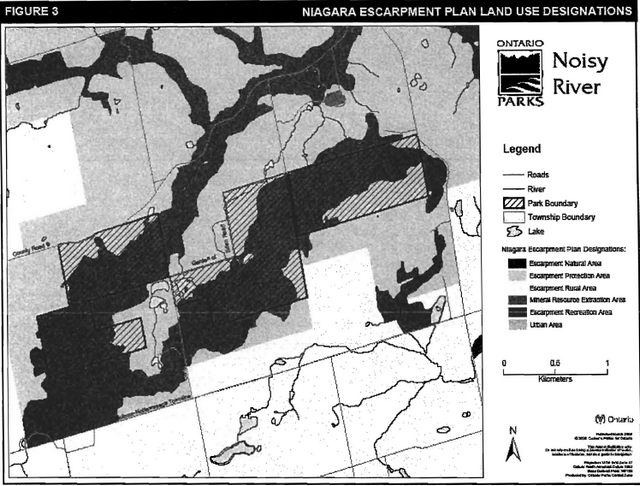
The Niagara Escarpment Plan, implemented by the Niagara Escarpment Commission, delineates seven land use designations, each outlining objectives and permitted uses. Noisy River Provincial Nature Reserve is surrounded by three of these designations: Escarpment Natural Area, Escarpment Protection Area and Escarpment Rural Area. The park itself is designated Escarpment Natural Area and Escarpment Protection Area (see Figure 3).
Escarpment Natural Areas contain features which are in a relatively natural state. Associated stream valleys, wetlands and forests which are relatively undisturbed are included within this designation. These contain important plant and animal habitats, geological features, cultural heritage features, and are the most significant natural and scenic areas on the escarpment (NEC, 2005).
Escarpment Protection Areas are important because of their visual prominence and their environmental significance. They are often more visually prominent than Escarpment Natural Areas. Included in this designation are escarpment features significantly modified by land use activities such as agriculture or residential development, land to buffer lands for prominent Escarpment Natural Areas, and natural areas of regional significance (NEC, 2005).
Escarpment Rural Areas are an essential component of the escarpment corridor, including portions of the escarpment and lands in its vicinity. They provide a buffer to the more ecological sensitive areas of the escarpment (NEC, 2005).
8.3 Water management
Sustaining high quality water resources is fundamental to the protection of park and adjacent land features and values. The Ontario Ministry of the Environment enforces applicable legislation and regulations pertaining to water quality.
Noisy River is a small headwater tributary of the Nottawasaga watershed, which empties into Georgian Bay via the Nottawasaga River at Wasaga Beach (Mackey & Schreiber, 1972). Noisy River is a very clean, clear river and has been noted as an important cold water fishery by the Niagara Escarpment Commission (NEC, 2005). Lavender Falls provides a natural physical barrier between the upstream brook trout (Salvelinus fontinalis) and the downstream migratory rainbow trout (Oncorhynchus mykiss) populations.
Noisy River has a variety of hydrological features, from slow moving pools to faster moving waters cascading over large rocks. Overhanging vegetation, rocks, fallen trees and debris provide essential cover for aquatic and terrestrial invertebrates.
The park features two artificial ponds. No action will be taken to maintain the pond sites. Natural processes will be allowed to proceed unmitigated, thereby producing a more natural condition and landscape. Action will be taken if this management approach creates direct and negative consequences related to the protection of physical assets outside of the park including roads or private property.
The policies in Section 2.6 of The Niagara Escarpment Plan (NEC, 2005) ensure new development affecting streams, watercourses, lakes, wetlands, and groundwater systems will have minimum individual and cumulative effects on water quality and quantity, and on the escarpment environment.
8.4 Non-native and invasive species
Where possible, actions will be taken to eliminate or reduce the threat of invasive non-native species which may be affecting the ecological integrity of naturally occurring populations. Where non-native species are already established and threaten natural or cultural values, a program of control may be undertaken if feasible and practical. Non-native species are species not native to Ontario or are species native to Ontario but not to the park. Non-native species will not be deliberately introduced. Invasive species are species that are likely to spread and negatively affect native ecosystems.
8.5 Forest fire management
Fire management in Ontario is based upon a division of the province by management objectives, land use, fire load, and forest ecology. Noisy River Provincial Nature Reserve is located within the Southern Ontario Fire Management Zone. In accordance with existing provincial park policy and the Forest Fire Management Strategy for Ontario, forest fire protection will be carried out in Noisy River Provincial Nature Reserve as on surrounding lands. Natural and human caused fires will be suppressed. Any prescribed fire management may be permitted by prescription and in a controlled setting. In the Southern Ontario Zone, municipalities have the lead in fire protection and management activities, under the Fire Protection and Prevention Act (FPPA) and through municipal by-laws. The MNR may be called for assistance if required.
8.6 Vegetation
Insects and diseases may be managed where the aesthetic, cultural, and/or natural features and values of Noisy River Provincial Nature Reserve are threatened. Control will follow guidelines established by the Ontario Ministry of the Environment and the Ontario Ministry of Natural Resources. Whenever possible, biological controls will be given preference over the use of chemicals.
8.7 Wildlife
Noisy River Provincial Nature Reserve is located in Wildlife Management Unit (WMU) 818, however, neither hunting, nor commercial fur harvesting is permitted in the park. Removal and/or harassment of non-game animals is not permitted in provincial parks (Provincial Parks and Conservation Reserves Act, 2006, effective September 4, 2007).
Occasionally, animals may pose as a threat to public safety, or to park facilities (e.g. beavers causing flooding, washouts of park roads, felling of trees). Wildlife management may be undertaken on an as required basis in order to protect health and safety of park visitors and park staff, or to protect park facilities. The removal of nuisance animals will be undertaken by, or under the supervision of the Park Superintendent.
8.8 Fisheries
Fisheries management will complement maintenance and enhancement of the native, self-sustaining fish populations. Non-native fish species will not be deliberately introduced into the waters of Noisy River Provincial Nature Reserve.
Sport fishing is permitted within Noisy River Provincial Nature Reserve. Any sport fishing activity is governed by the legislation and regulations in the Fish and Wildlife Conservation Act (1997), as well as the Federal Fisheries Act (1985). The Recreational Fishing Regulations Summary contains details regarding general regulations and exceptions to these regulations for the area of Noisy River Provincial Nature Reserve.
During inventory work done in 1987 and 2000, the following fish species were noted in Noisy River: brook trout, rainbow trout, longnose dace (Rhinichthys cataractae), creek chub (Semotilus atromaculatus), blacknose dace (R. atratulus), white sucker (Catostomus commersonit), mottled sculpin (Cottus bairdil), central mudminnow (Umbra limt), brook stickleback (Culaea inconstans), northern redbelly dace (Phoxinus eos), pearl dace (S. margarita), and fathead minnow (Pimephales promelas). Although brook and rainbow trout were stocked in the past, there is currently no stocking taking place on this river.
Noisy River Provincial Nature Reserve is located within a baitfish harvest area (HU11). The harvester requires Ontario Parks' permission to access the bait resources. Baitfish harvesting is a non-conforming use in the park. No new operations will be permitted.
8.9 Cultural resources
An assessment of the cultural resources specific to Noisy River Provincial Nature Reserve has not been completed at this time, however upon completion, management of any cultural features and values within this park will be directed toward protection and heritage appreciation.
8.10 Research
Scientific research by qualified individuals contributing to the knowledge of natural and cultural history and to environmental management will be encouraged. All research will be conducted by, or authorized by, Ontario Parks. Research projects will be administered through park policy directive and will require a research permit. Research must also meet all requirements under applicable provincial and federal legislation. Approved research and monitoring activities must be consistent with Ontario Parks' Research and Information Strategy (1997). Temporary facilities in support of approved research and monitoring activities may be considered. The collection of fossils, rocks, minerals, archaeological/cultural artefacts, plants, seeds and bioprospecting may be permitted by research permit and/or scienti'fic collector permit.
Approved research activities and facilities will be compatible with protection values and/or recreational uses in the park, and will be subject to development and management policies associated with the park’s classification unless special permission is given. Sites altered by research activities will be rehabilitated as closely to their previous condition as possible.
Figure 3: Niagara Escarpment Plan Land Use Designations
9.0 Operations policies
9.1 Recreation management
9.1.1 Motorized recreation
Motorized and non-motorized vehicles are not permitted in the park, including the section of the Bruce Trail within the park boundaries. The NEP (2005) also does not permit motorized vehicle trails or the use of motorized trail vehicles in the Escarpment Natural Area. This includes, but is not limited to, motor vehicles, trailers, all-terrain vehicles, bicycles, and other off-road vehicles. Snowmobiles are permitted only on existing, authorized trails within the park.
The use of motorized vehicles may occasionally be used for park maintenance or monitoring under the authority of the Park Superintendent.
Aircraft landings are not permitted in the park.
9.1.2 Non-motorized recreation
The park offers excellent hiking and landscape and wildlife viewing opportunities. The interior of the park can be accessed via the Bruce Trail footpath, which is managed in cooperation with the Bruce Trail Association and the local Blue Mountains Bruce Trail Club. In the winter, snowshoeing and cross-country skiing activities occur along the Bruce Trail. These activities are encouraged in nature reserve class parks.
Under the policies outlined for nature reserve class parks, camping is not permitted. However, six authorized campsites are located within park boundaries. These campsites are used by bikers/backpackers of the Bruce Trail (Figure 2). The campsites will be considered as a nonconforming use and will be allowed to remain subject to review by the Park Superintendent. The campsites may be removed and relocated to suitable areas outside the park. No expansion of the campsites or additional campsites will be permitted. Along the Bruce Trail there is also a permanent structure known as the Eden Shelter (Figure 2). The site is used as a rest stop for picnics or overnight stays on long hikes. This structure will be managed in cooperation with the Bruce Trail Association.
Unauthorized hiking trails and other non-mechanized trails that are documented at the time of the approval of the IMS will be reviewed. The Park Superintendent may close existing unauthorized trails if it is determined that they threaten park features and values, create user conflicts or raise safety and/or liability issues.
If there is an identified need, the development of new trails may be considered in future planning. Any proposed development within Noisy River Provincial Nature Reserve is subject to the Class Environmental Assessment for Provincial Parks and Conservation Reserves.
Mountain biking, horseback riding, camping and open fires are not permitted in nature reserve class parks. Existing canoe/kayak use may continue, unless park values are threatened.
9.1.3 Emerging recreation uses
Adventure racing is not permitted. Geocaching may be permitted at the discretion of the Park Superintendent.
There are emerging recreation uses for which there is no or limited policy to deal with their management. In the interim, the Park Superintendent will use legislation, park policy and guidelines to manage emerging uses. The Park Superintendent will also work with the Midhurst MNR District Office to manage these emerging uses.
9.2 Heritage education
Basic literature and supporting information may be developed to describe Noisy River Provincial Nature Reserve in the context of Ontario’s provincial parks and protected areas. Boundary limits, significant heritage features and permitted uses of the nature reserve park may be included in park literature.
Prospective visitors to Noisy River Provincial Nature Reserve may be informed ·about the sensitivity and significance of this park through park literature and the Ontario Parks' website.
10.0 Development
Development within the park is limited to the Bruce Trail, the Eden Shelter, and several campsites. Gates and fences have been installed at access points and along the northern boundary of the park. There are also signs located throughout the park. Existing facilities will be maintained. A small parking lot for a limited number of cars may be constructed in the future at one of the access points, if demand and cost/benefit warrant.
Decisions regarding new development will comply with A Class Environmental Assessment for Provincial Parks and Conservation Reserves. Development will be carried out in accordance with approved site plans, utilizing appropriate standards and in conformity with relevant legislation and policy, including the NEP and NEPDA.
Unnecessary undirected light pollution will not be allowed in any future development. Outdoor lighting will be limited to basic safety requirements and will be shielded when possible. This commitment recognizes the natural values provided by a pristine night sky.
11.0 Interim Management Statement amendment and review
The park Interim Management Statement can be reviewed or amended to address changing issues or conditions. At ten year intervals, this Interim Management Statement will be assessed for the need for a review or amendment. A review may involve a reassessment of all or part of the plan, including classification and all resource management, operations and development policies. An amendment can be considered to address specific issues or needs. Any person may initiate an amendment process by submitting a proposed amendment, with an explanation of its purpose, to Ontario Parks, which will determine whether, and under what conditions, the amendment process should proceed.
12.0 References
Brownell, V.R. 1980. A Life Science Inventory and Evaluation of the Lavender Falls Study Area. Environmental Planning Series. OMNR, Parks and Recreation Section, Central Region, Richmond Hill.
Jalava, J.V. 1995. Lavender Falls Site Summary. pp. 308-311, in, J.L. Riley, J.V. Jalava and S. Varga. 1996. Ecological Survey of the Niagara Escarpment Biosphere Reserve. Volume 1: Significant Natural Areas. Ontario Ministry of Natural Resources, Southcentral Region, Peterborough, Ontario. Open File Site Report SR 9601. v+ 629 pp., vii+ 310 pp.
Kelly, Peter E. and Douglas W. Larson, 2003. Cliff-face Eastern White Cedar Forests on Ontario Parks' Propetties Along the Niagara Escarpment: A Summary of Inventory Work Completed by the Cliff Ecology Group. Cliff Ecology Research Group, University of Guelph.
Korol, Burke, 2003. A Detailed Life Science Inventory of Noisy River Provincial Nature Reserve. Central Zone, Ontario Parks, Huntsville.
Lindenburger, Ruth, 2003. Noisy River Provincial Nature Reserve Recreation Resource Inventory Report. Central Zone, Ontario Parks, Huntsville.
Mackey, Heather and Mary Schreiber, 1972. Noisy River Valley: Ecological Assessment. Ontario Ministry of Natural Resources; Parks Branch, Toronto.
Niagara Escarpment Commission (NEC), 2005. The Niagara Escarpment Plan. Niagara Escarpment Commission, Georgetown, Ontario, www.escarpment.org webpage.
Nottawasaga Valley Conservation Area (NWCA), 1993. Watershed Management Plan. http://www.nvca.on.ca/watershed/index.htm (link no longer active) webpage. Last accessed: March 3, 2006.
Ontario Ministry of Natural Resources (OMNR). 1974. A Topical Organization of Ontario History. Historic Sites Branch Division of Parks.
Ontario Ministry of Natural Resources (OMNR). 1986. Lavender Falls Candidate Provincial Park Interim Interim Management Statement. OMNR, Ontario Parks.
Ontario Ministry of Natural Resources (OMNR). 1992. Ontario Provincial Parks Planning and Management Policies.
Ontario Ministry of Natural Resources (OMNR). 2001. Trapping in new OLL Parks.
Ontario Ministry of Natural Resources (OMNR). 2003. Directions for Commercial Resource Use Activities in Provincial Parks and Conservation Reserves. 5 pp.
Ontario Ministry of Natural Resources (OMNR). 2004a. Crown Land Use Policy Atlas.
Ontario Ministry of Natural Resources (OMNR). 2004b. Fire Management Strategy for Ontario. Aviation and Fire Management Branch.
Ontario Ministry of Natural Resources (OMNR). 2005. Class Environmental Assessment for Provincial Parks and Conservation Reserves.
Ontario Ministry of Natural Resources (OMNR). 2006a. Hunting Regulations Summary.
Ontario Ministry of Natural Resources (OMNR). 2006b. Recreational Fishing Regulations Summary.
Provincial Parks Act RSO, 1990.
Provincial Parks and Conservation Reserves Act (Draft), 2006.
Thompson, Melinda. 2006. Detailed Inventory of Butternut (Juglans cinerea) in Twelve Central Ontario Provincial Parks. Dougan & Associates Ecological Consulting Services, Guelph, Ontario.
Appendix 1 - Background information
| Name | Noisy River Provincial Nature Reserve |
|---|---|
| Classification | Nature Reserve |
| Ecoregion/Ecodistrict | 6E / 6E7 |
| OMNR Administrative Region/District | Southern / Midhurst |
| Ontario Parks | Central Zone -Wasaga Beach P.P. Cluster |
| Total Area (ha) | 378 |
| Regulation Date & Number | May 1989 (O. Reg. 290/89) |
Representation
Earth science
Noisy River Provincial Nature Reserve encompasses several significant earth science features, including an incised gorge and the upper portions of the Noisy River valley which opens north eastward and is one of the larger re-entrant valleys along the Niagara Escarpment. The bedrock of the Noisy River valley is sedimentary. The base structure of the bedrock consists of flat laying rocks created during the Ordoviacian and Silurian periods of the Palaeozoic Era, approximately 400 million years ago. The rock type found on the escarpment is known as dolomitic limestone, a calcium-magnesium rich rock type (Lindenburger, 2003). Shallow soils and dolostone bedrock exposures of the Amabel Formation occur along and above the escarpment rim, with deeper sandy silt till found back from the rim. Clayey silt till, rich in shale fragments of the Queenston Formation, predominates along the western valley slopes. An area of ice-contact, partly stratified, sand deposits are also present in that area. The upper eastern slopes have extensive talus on Silurian formations, while the lower portions, including the Noisy River valley bottomlands, are composed of shales of the Queenston Formation, with occasional outcrops (Jalava, 1995).
Life science
Noisy River Provincial Nature Reserve is located in Ecodistrict 6E-7, which has an area of 442,551 ha. Ecoregion 6E is characterized by mid-humid Great Lake hardwoods, found on gently undulating to rolling terrain of ice-laid materials. Ecodistrict 6E-7 is an area of land averaging 15 km in width and includes the Niagara Escarpment south of Collingwood to an area northwest of Brampton. Ecodistrict 6E-7 also extends eastward over to, and including the Oak Ridges Moraine. The Ecodistrict is characterized by deep sand and gravel deposits, overlain locally by very high lime clay, silt and loam (Hills, 1959).
The park is situated on a portion of the Niagara Escarpment. The escarpment is a unique natural landform, which supports plant communities and species that are not comparably represented anywhere else in the world. The area is well known to botanists as a virtual paradise for rare ferns and orchids (Korol, 2003). In 1990, the United Nations Educational, Scientific and Cultural Organization (UNESCO) designated the Niagara Escarpment as a World Biosphere Reserve in recognition of its natural heritage significance, and to recognize and endorse the Niagara Escarpment Plan. The Niagara Escarpment Plan was Canada’s first large-scale environmental land use plan, which uses policies to ensure the escarpment remains a sustainable natural environment for future generations (Lindenburger, 2003).
Noisy River Provincial Nature Reserve is partially located within the Lavender Falls Life Science Area of Natural and Scientific Interest (ANSI)
Cultural resources
There has been no examination of the cultural values that may exist within Noisy River Provincial Nature Reserve.
Recreation & tourism
The park’s landform features provide a variety of recreation opportunities including hiking/backpacking, nature appreciation, camping, landscape and wildlife viewing, exploring, picnicking, sport fishing, skiing, and snowshoeing.
The Bruce Trail travels through Noisy River Provincial Nature Reserve providing access into the park and also generating attention from outdoor enthusiasts.
Inventories
| Survey Level | Earth Science | Life Science | Cultural | Recreational |
|---|---|---|---|---|
| Reconnaissance | Cordiner, 1978 | Brownell, 1980 | Required | Belan & Moreau, 1984 |
| Detailed | Schreiber & Mackey 1972 | Korol, 2003 | Required | Lindenburger, 2003 |
Footnotes
- footnote[1] Back to paragraph Lavender Falls Provincial ANSI includes the former Dunedin Regional ANSI.