North of the North French River Conservation Reserve Management Statement
This document provides policy direction for the protection, development and management of the North of the North French River Conservation Reserve and its resources.
Enhanced Statement of Conservation Interest
October 2005
Approval statement
I am pleased to approve this Enhanced Statement of Conservation Interest (ESCI) for North of the North French River Conservation Reserve (C1606).
Direction for establishing, planning and managing conservation reserves is defined under the Public Lands Act, the Ontario’s Living Legacy Land Use Strategy, and other applicable policies. The specific direction for managing this conservation reserve is in the form of an ESCI, which defines the area to which the plan applies, provides the purpose for which the conservation reserve has been proposed, and outlines the Ontario Ministry of Natural Resources' management intent for the protected area.
This ESCI has been created with input from program specialists within the Cochrane District Ministry of Natural Resources. It will provide guidance for the management of the conservation reserve and the basis for the ongoing monitoring of activities. More detailed direction at this time is not anticipated. However, should significant facility development be considered or complex issues arise requiring additional studies, more detailed management direction in the form of special protection measures, or a detailed Resource Management Plan, will be prepared with full public consultation.
Public and Aboriginal consultation occurred prior to the regulation of this conservation reserve and prior to the approval of this management document. Comments from the notification periods have been considered in the development of this document.
The North of the North French River Conservation Reserve will be managed under the jurisdiction of the Iroquois Falls Area Supervisor of the Ontario Ministry of Natural Resources, Cochrane District.
Plan Author:
Rachel Foley
Resource Planner
Cochrane District
Approved by:
Original signed by Ed Tear
Ed Tear, District Manager
Cochrane District OMNR
Date: October 7, 2005
Original signed by Rob Galloway
Rob Galloway, Regional Director
Northeast Region OMNR
Date: October 31, 2005
1.0 Introduction
Ontario’s network of natural heritage areas has been established to protect and conserve areas representative of the diversity of the natural regions of the province. Natural heritage areas are a key component in sustainable management of natural resources and require protection from incompatible activities if their values are to endure over time. The Ontario Ministry of Natural Resources (OMNR) has established conservation reserves as a tool to offer protection for these natural heritage areas on public lands, while still permitting many traditional uses to continue.
The North of the North French River Conservation Reserve is a natural heritage area that was selected for protection during the Ontario’s Living Legacy (OLL) planning process. This conservation reserve lies approximately 70 kilometers north of the town of Cochrane and is situated entirely on unsurveyed Crown land. This conservation reserve was created to protect an esker complex, numerous string bogs and a chain of small lakes. The site additionally contains dense conifer forest, mixed deciduous forest and a small amount of sparse forest.
The following document is an Enhanced Statement of Conservation Interest (ESCI) for this conservation reserve. The purpose of the ESCI is to identify and describe the natural, recreational, and cultural values of North of the North French River Conservation Reserve. This ESCI will also outline the intent that OMNR has with regards to the management of the area. The management direction outlined in this document will protect the site’s natural heritage values and demonstrate its compatibility within the larger landscape.
Section 2.0 of this document outlines the goals and both the short and long term objectives for this ESCI. Section 3.0 provides the provincial context for the creation and management of conservation reserves, and summarizes the planning process for the North of the North French River Conservation Reserve. Sections 4.0 and 5.0 provide site specific background information regarding earth science values, life science values and cultural values. Management direction for the North of the North French River Conservation Reserve is outlined in Section 6.0 and includes direction regarding industrial, commercial and recreational activities. Finally, Section 7.0 and 8.0 summarize the suggested recommendations for future assessment work and outline the requirements for continued implementation and review of this document.
Staff of the Cochrane District of the OMNR will be responsible for implementing the management policies and guidelines for North of the North French River Conservation Reserve. Their primary role will be to provide public information and perform compliance monitoring to ensure adherence to current policies. In addition, staff of the Cochrane District will be responsible for evaluating any new proposed activities within the conservation reserve.
2.0 Goal and objectives of the ESCI
2.1 Goal
The intention of a conservation reserve, as stated in Policy PL 3.03.05 for Conservation Reserves (OMNR, 1997a) is to protect natural and cultural heritage values on public lands while permitting compatible land use activities. It is the goal of this Enhanced Statement of Conservation Interest to provide the framework and direction to guide management decisions to ensure that the North of the North French River Conservation Reserve will meet that intention.
2.2 Objectives
The following short and long term objectives have been identified for this ESCI as the means to achieve the above stated goal:
2.2.1 Short term objectives
The short-term objectives for the ESCI, which will be accomplished upon approval of this document, are:
- To identify and describe current natural heritage values and land use activities for the North of the North French River Conservation Reserve in order to provide baseline information for future assessment
- To outline the guidelines, strategies and prescription that will place a priority on the protection of the site’s natural values
- To ensure protection of natural and cultural heritage features and values by establishing an evaluation process to address future uses; and
- To meet the legislated planning requirement to develop a management document within three years of site regulation
2.2.2 Long term objectives
Long term objectives for this ESCI are:
- To identify client services and marketing strategies that may be required in the future to create public awareness and support responsible stewardship of the conservation reserve; and
- To identify future research needs that would allow the establishment of representative targets (i.e. forest conditions) to validate the site as a potential scientific benchmark
3.0 Management planning
3.1 Provincial context
The need to complete the parks and protected areas system has long been recognized as an important component of ecological sustainability. As a result of an extensive planning process conducted in Ontario between 1997 and 1999, the Ontario’s Living Legacy Land Use Strategy (LUS) (OMNR 1999a) was developed and released on July 19, 1999. One of the main objectives of this strategy was to complete Ontario’s system of parks and protected areas (OMNR 1999a) through which natural and cultural heritage values would be protected and opportunities for outdoor recreation, heritage appreciation and tourism would be provided.
3.2 Planning process for a conservation reserve
Following the regulation of a site, management planning for a conservation reserve begins. The purpose of a management plan is to identify the state of the resource in terms of the site’s values and its current land use activities. The plan additionally outlines the Ministry of Natural Resources' management intent for the conservation reserve.
The management document for a conservation reserve can take one of three forms: a basic Statement of Conservation Interest (SCI), an enhanced SCI or a Resource Management Plan (RMP), all of which are prepared with public and First Nation consultation.
A basic SCI is prepared when there is no deviation from the land use direction provided in the LUS (OMNR, 1999) and there are few to no issues that require resolution. Alternatively, a RMP is prepared in situations where complex issues have to be addressed, and/or where there is widespread public interest in a site. An enhanced SCI is an intermediary document which is used when a site requires more detailed management direction than would be provided by a basic SCI, but does not have issues significant enough to warrant the preparation of a RMP. Whichever the determination, the plan must be completed within three years of the conservation reserve’s regulation date. The guidelines for the preparation of these documents are provided in Procedural Guidelines A – Resource Management Planning (OMNR 1997b) and the Northeastern Region Guidelines on the Planning Process for Conservation Reserves: Statement of Conservation Interest and Resource Management Plan (Thompson, 2001).
Direction for the continued management of conservation reserves complies with land use intent found in the Ontario’s Living Legacy Land Use Strategy (OMNR, 1999a) and subsequent policy updates (OMNR, 2001). The Class Environmental Assessment for Provincial Parks and Conservation Reserves (OMNR, 2003) will be used to screen all project proposals and management activities occurring within the conservation reserve however, where cultural resources may be impacted, proposals may additionally be screened as outlined in section 6.2 Cultural and Archeological Values.
3.3 Planning process for north of the North French River Conservation Reserve
3.3.1 Planning area
The planning area will consist of the regulated boundary for the North of the North French River Conservation Reserve as defined in section 4.1 Administrative Description.
This land base will form the area directly influenced by this ESCI. This plan will outline management direction for the protection of values within the planning area however, to fully protect values within the conservation reserve, additional consideration within larger land use or resource management plans may be required. The Ministry of Natural Resources, in conjunction with other partners where appropriate, will work to ensure that the values of the conservation reserve are not negatively impacted during the planning and implementation of activities on the surrounding land base.
3.3.2 Management planning
The North of the North French River Conservation Reserve is the largest conservation reserve in Ontario and historically there has been significant interest in this area (see section 4.1 Site History). Management of this area is primarily governed by the general policies in the Land Use Strategy (OMNR, 1999a) and subsequent updates.
This area additionally falls within the boundaries of the Approved Cochrane District Remote (Wilderness) Tourism Strategy (RWS) (OMNR, 1997c) and as such, specific prescriptions will be consistent with this local strategy as well.
Given the size of the conservation reserve, the historic interest in the area and the clarification required with respect to the overlapping local land use strategy, it was determined that management document for the site should be as detailed as possible and provide more site specific information than what would normally be found in a basic SCI. There are, however, currently no complex issues relating to this conservation reserve which require resolution. As such, it was decided that the appropriate management document would be an Enhanced Statement of Conservation Interest.
This document provides background information, identifies values to be protected and establishes management guidelines for the conservation reserve.
This ESCI was created with input from program specialists at the district and regional levels of the Ministry of Natural Resources. Members of the public, aboriginal communities and industry were provided an opportunity to comment on a draft of this document. A public consultation period took place from July 29 – August 29, 2005. Notification of this review period occurred through a letter mailed to potentially affected stakeholders and through an advertisement that appeared in local newspapers. The Ministry of Natural Resources is exempt from providing notification of this planning process on the Environmental Bill of Rights Electronic Registry, under Section 30 of the Environmental Bill of Rights. Comments received were considered in the refinement of this document.
Upon approval of this Enhanced Statement of Conservation Interest, public notification will occur via mail-out to stakeholders who submitted comments and a notice will appear in the local newspapers.
This ESCI is a working document and therefore may require revisions from time to time. For further information on reviews and revisions please see Section 8.0: Implementation, Marketing, Review and Revisions
4.0 Background information for north of the North French River Conservation Reserve
4.1 Site history
The North of the North French River Conservation Reserve is located approximately 70 kilometers north of the town of Cochrane and is situated entirely on unsurveyed Crown Land.
Historically, this area has been used by local First Nation communities. The area has been identified as being within the traditional lands of the Moose Cree First Nation who have generally used the area for game and fowl hunting, fishing and gathering. As well, the conservation reserve encompasses several of their traditional waterway and overland travel routes, including several camping/portage sites. The Wekweyaukastic and Little Wekweyaukastik Rivers have additionally been identified as traditional canoe routes by both the Taykwa Tagamou Nation and the Wahgoshig First Nation.
In 1983, the Cochrane District Land Use Guidelines (DLUG) (OMNR, 1983) designated the area as the Wekweyaukastik River Area (Area 6) and recognized that the area contained numerous remote tourism lakes and many commercial outpost camps. The DLUG stated that the area would have a priority toward the promotion and limited expansion of the commercial tourist industry however recognized that the area did have conflicting land uses from various resource users.
In 1993, in an attempt to resolve conflicting land use issues, the OMNR brought together a committee of stakeholders from various industries including forestry, mining and remote tourism as well as representatives from outdoor associations, municipalities and government ministries. The purpose of the committee was to develop a comprehensive strategy that detailed where and how remote tourism would receive protection within portions of Cochrane OMNR District. In 1997, the Cochrane District Remote Wilderness Tourism Strategy (RWS) was finalized and approved (OMNR, 1997c). The resulting strategy re-defined approximately 75% of the DLUG Area 6, as the Remote Tourism Management Area of the North of the North French River and similar to the DLUG designation, continued to place a priority on the protection of the remote tourism values.
Under the RWS guidelines, forestry within the remote tourism management area was prohibited and restrictions surrounding mining exploration activities were imposed. Recreationally, snowmobiling was permitted to continue as was public access for fishing and hunting activities by traditional means (air, foot or canoe). Winter fishing however (November 1 to May 14) was prohibited on designated tourism lakes (OMNR, 1997c).
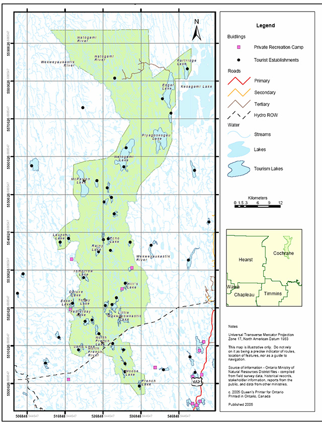
In 1999, this area was again brought to the table, this time appearing in the OLL LUS as the proposed North of the North French River Conservation Reserve. The proposed boundaries captured the RWS boundary and additionally included area to the north. Public consultation regarding this area a conservation reserve began in 2000 and included consultation with interest groups, local stakeholders, industry, and aboriginal communities. A letter, fact sheet and proposed boundary map were mailed to all interested parties and an advertisement was placed in the local newspapers. This site changed very little from its appearance in the LUS, with most boundary changes being made to follow natural features where possible. Figure 1 illustrates past and present land use designations in the area as a result of the various planning processes.
Figure 1: Historical land use boundaries for north of the North French River area
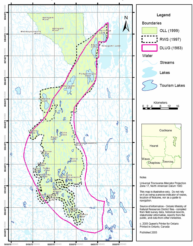
Enlarged figure 1: Historical land use boundaries for north of the North French River area (PDF)
4.2 Location and administrative information
The North of the North French River Conservation Reserve was formally regulated as schedule 265 of Ontario Regulation 181/05 made under the Public Lands Act on April 20, 2005 and filed April 21, 2005, amending Ontario Regulation 805/94. The legal description as found in the May 7th, 2005 edition of the Ontario Gazette, reads as follows:
The official Ontario Gazette amendment is available on the internet at http://www.ontariogazette.gov.on.ca/. Figure 2 illustrates the final boundary for this site. Additionally, Table 1 provides further administrative information regarding the North of the North French River Conservation Reserve
Table 1: Administrative Information
| OMNR Administrative Region and District | Northeast Region - Cochrane District |
|---|---|
| Township | Unsurveyed lands |
| Nearest Town | Cochrane, located 70 km south west of the conservation reserve |
| Area (ha) | 158,286 |
| Altitude (meters above sea level) | Min 130- Max 320 m |
| Topographical Map Name/Number | North Burntbush Lake –42H/09 Montreuil Lake -42H/10 Tomorrow Lake – 42H/15 Lawagamau Lake –42H/16 |
| UTM Reference | 5315545 |
| Latitude/Longitude | 50°05'47"N/80°36'35"W |
| First Nations | James Bay Treaty #9, local First Nations affiliated with this treaty area include Moose Cree First Nation, Wahgoshig First Nation and Taykwa Tagamou Nation |
| Wildlife Management Unit | WMU 12 |
| Forest Management Units | Iroquois Falls Forest Cochrane Moose River Management Unit |
| Watershed | 4MF tertiary watershed of the Moose River major basin |
| Site Region–Site District (Hills 1959) | 2E-3 |
| Ecoregion–Ecodistrict (Crins and Uhlig 2000) | 3E-7 |
Figure 2: Administrative Information
Enlarged figure 2: Administrative Information
4.3 Inventories
Since the proposal of this site as a conservation reserve, numerous inventories have been completed for this area. These inventories, in addition to preliminary work and gap analysis completed during the site identification phase, have been used to confirm and further delineate the values of the site. These values are summarized in Section 5.0 however for more detailed information the reader is referred to the appropriate report(s), outlined in Table 2, which are available by contacting the Cochrane District OMNR office.
Table 2: Summary of Inventories completed
| Type of Inventory | Inventory Method | Dates of Inventory | Report |
|---|---|---|---|
| Life Science | Aerial reconnaissance | September 29 - October 2, 2003 | December 7, 2004 Life Science Checksheet – Step 2 Barbara Burkhardt, Lori King, Angie Schultz |
| Earth Science | Aerial reconnaissance and photo interpretation | September 29 - October 2, 2003 | November 16, 2004 Draft Earth Science Report F.J. (Rik) Kristjansson, Consulting Geoscientist |
| Recreation | Aerial reconnaissance | September 29 - October 2, 2003 | January 2004 Recreation Inventory Report Mary Kirkbride |
5.0 State of the resource
The benefits of protected areas for the people of Ontario include clean air, clean water, outstanding landscapes, natural diversity, recreation opportunities and social and economic well-being. This section outlines both the key values protected within the North of the North French River Conservation Reserve as well as the quality and condition of those values.
5.1 Representation
Completing the system of protected natural heritage areas is based on the concept of representation. This concept has developed worldwide over the past quarter century as a method to help conserve biological diversity. Its fundamental principal is that protected areas should included representative examples of known biodiversity within ecologically defined regions (Ontario Parks, 2004). The complete protected areas system must therefore represent a wide range of the province’s geological, biological and cultural values.
Values and representative features that the North of the North French River Conservation Reserve contributes to the protected areas system are further described below.
5.1.1 Earth science values
Earth science values are based on protecting selected examples of Ontario’s geological history and its physical expression on the landscape. Through development and management of protected areas, Ontario attempts to identify and preserve examples of each known rock type, fossil assemblage, landform and geological process, as well as suites of features that define the significant geological events through time. Representative features can range in size from an individual outcropping of rock to a large glaciated landscape (Ontario Parks, 2004).
5.1.1a Regional landforms
The late glacial and deglacial history of northeastern Ontario has resulted in many of the regional surficial landforms that currently dominate the area. During the withdrawal of a glacial ice mass from the region, much of the area was inundated by a glacial lake known as Lake Ojibway. As the glacier continued to recede across the low lying land, a symmetrical and well-integrated meltwater drainage system developed. This drainage system conveyed an abundance of meltwater to the Lake Ojibway basin and substantial glaciolacustrine sediment was deposited within the lake. During a subsequent glacial event, referred to as the Cochrane re-advance, the area was again entirely overridden by glacier ice and then went through a similar pattern of deglaciation, inundation by glacial Lake Ojibway, and glaciolacustrine sedimentation. As deglaciation continued, increased meltwater would have caused the Tyrrell Sea, a massive body of water that covered the Hudson Bay and James Bay lowlands, to rapidly invade the area. Lake Ojibway subsequently drained into the invading Tyrell Sea and glaciomarine sediments were deposited throughout the area. Ocean waters of the Tyrell Sea subsequently withdrew to form the shorelines we are familiar with today.
These events in geological history have resulted in a topography strongly influenced by glacial activity and the dominant landforms throughout the region include eskers, sub-aquatic outwash fans, till deposits, drumlinoidal ridges and glaciolacustrine deposits (Kristjansson, 2004).
5.1.1b Local surficial geology
Like the regional geology, the local surficial geology of the conservation reserve has also been strongly influenced by past glacial activity.
Thick, generally continuous deposits of till immediately underlie most of the north part of the conservation reserve. In the east central and southern regions of the site, glaciolacustrine deposits dominate the surficial geology while the remaining central portion of the conservation reserve is underlain by organic deposits (see Geology Map, Appendix D).
The conservation reserve additionally contains glaciofluvial ice contact deposits which are most evident as esker systems. Two esker systems associated with the Cochrane readvance are particularly noteworthy. One esker is located in the south west portion of the site (Figure 3) and trends approximately north-south, the other is located in the central and south-east parts of the site and also trends north-south (Kristjannson, 2004). The esker system is of particular note as it is the best example within the ecodistrict and is one of only three major north-south orientated systems in the ecodistrict (Burdkardt, 2004). The esker systems exhibit well-developed, relatively continuous, individual esker ridges, with associated subaquatic outwash fans. Relatively large kettle holes, many of which are occupied by small lakes, are associated with these esker systems.
Figure 3: Esker-kettle complex near western boundary of site.
The conservation reserve additionally contains a number of glaciomarine deposits as a result of past inundation by the Tyrrell Sea. Elevations less than 182 m above sea level would have been flooded and as a result various raised deltaic forms are present including distributary channels and bars. These range in elevation from 135 m to 150 m above sea level. Additionally, shoreline forms which have tentatively been interpreted as storm beaches are present in the extreme northwest part of the conservation reserve and range in elevation from 130 to 150 meters. It is very likely that both the raised deltaic forms and the shoreline forms are representative of the Tyrrell Sea at levels near the marine limit (Kristjansson, 2004).
Alluvial landform development is present along sections of some rivers and their tributaries. (Kristjansson, 2004). The meandering styles, point bar development and occasional cut-off meander loops that are evident along some river sections add considerably to the local geological diversity of the conservation reserve.
More research is currently being conducted by Rik Kristjansson, OLL Geologist, on the landforms present in this conservation reserve. There may be mega scale glacial lineation till present in the site which would make this site provincially significant from an earth science perspective (Cudmore, 2004).
5.1.1c Local bedrock geology
The bedrock of this area largely consists of metasedimentary paragneisses and migmatites with smaller areas of granodiorite and granite. Additionally, some areas in the north of the conservation reserve are underlain by part of an east-west trending belt of mafic to intermediate metavolcanic rocks. Portions of two east-west trending belts of massive to foliated granitic rock also occur in the north portion of the site.
Several rock outcroppings (Figure 4) have been documented in the northern portions of the reserve and exposed rock is evident along the shorelines of larger rivers.
Figure 4: Rock outcrops to the east of the Natogami River
5.1.2 Life science values
Ontario’s approach for representation of terrestrial ecosystems uses naturally occurring associations of land formation and vegetation as surrogates for biodiversity. Through the creation of parks and protected areas, Ontario attempts to preserve a wide variety of different landform vegetation units across the province.
5.1.2a Regional ecology
Ontario’s system of Ecological Land Classification is based on the ecoregion concept (Crins and Uglig, 2000). This concept groups regions together based on broad climatic patterns (temperatures, precipitation). Ecoregions (Ecoregion Map, Appendix E) are further subdivided into ecodistricts which are delinated based on similarities in land formation and predominant vegetation (Ontario Parks, 2004).
This conservation reserve lies within ecodistrict 3E-7 (Crins and Uhlig 2000). This ecodistrict is characterized as being an area of muskeg frequently broken by low ridges of shallow till with unmerchantable spruce. The occasional kame or esker is also present, and sandy ridges are generally apparent, usually with a mixed spruce-fir-poplar forest.
A classification relating more specifically to the regional forest composition is based on the Forest Regions for Canada, which was established by Rowe in 1972. This classification is based on geographic zones having vegetation cover that is fairly uniform in terms of dominant species and stand types. This classification relies predominately on the nature of the vegetation and forest composition, unlike ecological classification which also uses climatic patterns and land formations. (http://www.cfl.scf.rncan.gc.ca/ecosys/classif/intro_regions_e.asp) (link is no longer active)
The North of the North French River Conservation Reserve is situated in two different forest units, Section B4 and Section B5.
Section B4 (Northern Clay) is characterized by extensive black spruce forests on rising uplands and on lowland flats. Hardwood or mixed wood stands of trembling aspen, balsam poplar, balsam fir, white spruce and black spruce stand can be found where improved drainage has occurred. Jack pine is dominant on drier sites such as outwash deposits, old beaches and eskers while white birch is prominent on sandy soils.
Section B5 (Hudson Bay Lowlands) contains marine clay and beach sand deposit, has a flat topography and is poorly drained. Rivers run roughly parallel to each other and the low alluvial banks provide conditions for good growth of forest. The vegetation in this Section can be considered 'subaquatic' due to the prominence of open expanses of black spruce and tamarack in the muskegs and patterned fens. The organic deposits can support dense cover of lichens. Similar to Section B4, forests of white spruce, balsam fir, trembling aspen, balsam poplar and white birch occupy better drained river banks (Burkhardt, 2004).
Figure 5: Over mature white birch
5.1.2b Local vegetation and forest communities
The forest landscape of the conservation reserve is reflective of the ecodistrict, and of both Forest Regions as described above however the conservation reserve most predominately reflects Section B5 (Hudson Bay Lowlands) of Rowe’s Forest Regions.
The conservation reserve is predominately black spruce and is dominated by pure black spruce stands, which account for roughly 34% of the total area of the conservation reserve. Black spruce conifer dominant stands account for an additional 8%. Much of the black spruce dominated stands are over 100 years of age. Interspersed with these black spruce stands are treed muskeg areas, which account for approximately 20% of the site area.
Jack pine communities are also present in some areas, most notably on an esker system which runs along the Natogami River in the northwest corner of the conservation reserve. These jack pine communities are unique in that they are beyond their northern limit. In addition, there are stands of trembling aspen, balsam poplar, white birch and balsam fir. (see Forest Communities Map, Appendix E)
Several other stands occurring within the conservation reserve are over 200 years old including some balsam fir true mixed stands and black spruce poplar true mixed stands (see Age Distribution Map, Appendix E). Currently, the oldest known stand in the conservation reserve is a birch dominate conifer stands located east of Today Lake which was determined to be 211 years old.
5.1.2c Wetlands and watersheds
The site is part of the Hudson Bay watershed system and is largely comprised of several quaternary watersheds flowing into the 4MF tertiary watershed of Moose River major basin. A divide between tertiary watersheds 4MF and 4NC occurs in the extreme northeast area of the reserve, with waters of the 4NC watershed flowing north and east into the Partridge and Harricanaw River systems. (Kirkbride, 2004)
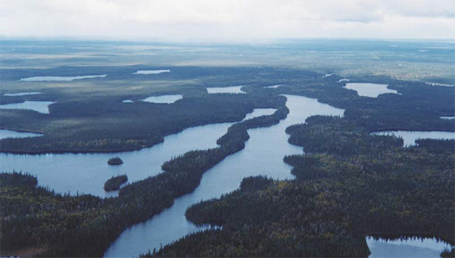
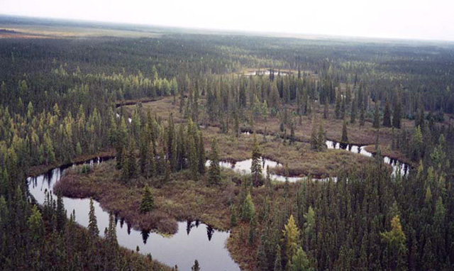
The conservation reserve features several water bodies exceeding 1,000 hectares including McParlon, Natogami, Edgar and Piyagoskogau Lakes. The more upland sites in the south eastern and central portions of the reserve feature a significant concentration of small to mid-size lakes and chains of lakes, interspersed with permanent wetland areas.
The boundaries of the conservation reserve additionally are made up of and capture numerous rivers. The Cochrane re-advance (Section 5.1.1a) imparted a linear type fabric to the region and as a result, many of the tributaries in the area run roughly parallel to each other in a north-north-west trend. Named rivers in the area include the Wekweyaukastik River (Figure 6), which bisects the reserve and forms part of both the northwestern and eastern boundaries and the North French River which forms part of the southwestern boundary. Other rivers which flow through the site include the Wawagigamau River, the Natogami River, the Mitinigap River, and the Kiyask River.
Figure 6: Wekweyaukastik River on the eastern boundary, low shrub shore fen along river
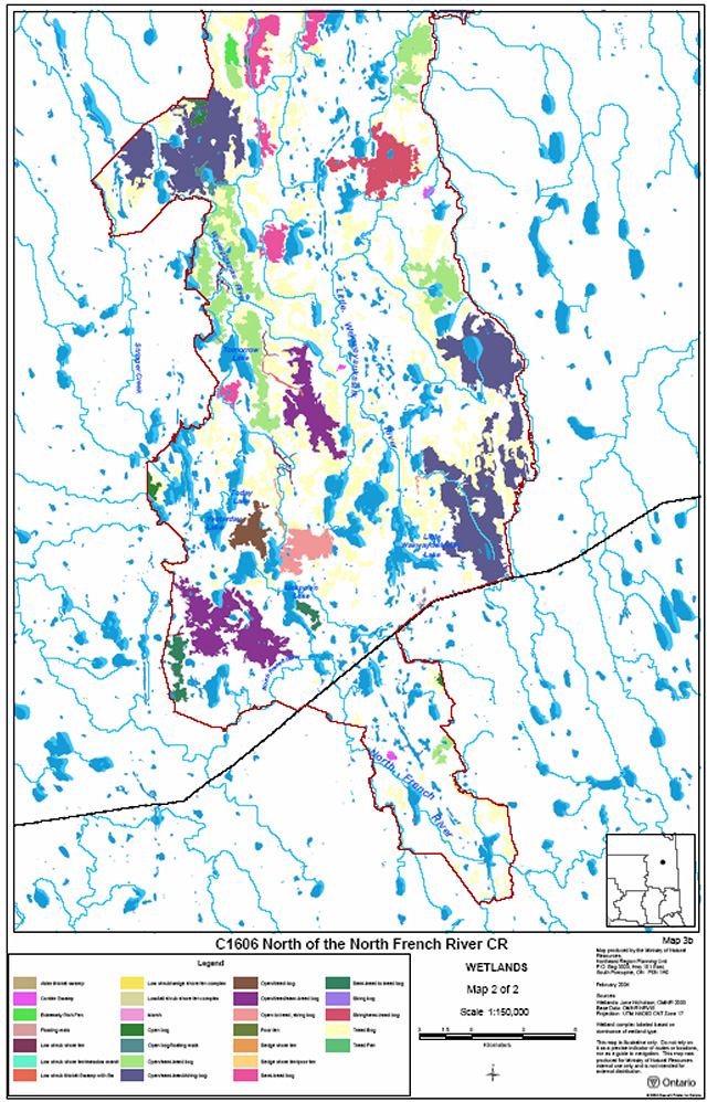
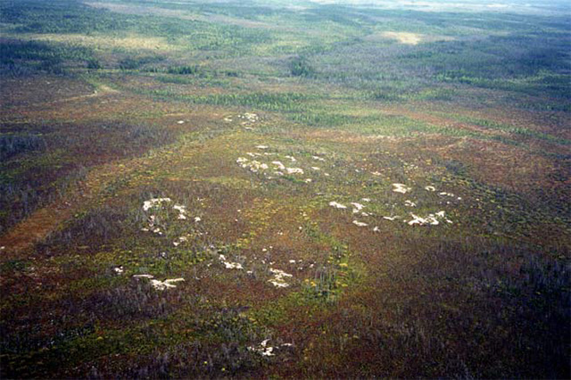
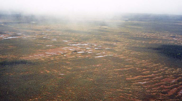
Wetlands play a dominate role in this conservation reserve and account for a large portion of this site (Wetlands Map, Appendix E). Many of the open and treed muskegs have been classified as complexes consisting of open, semi-treed, treed or string bog (Figures 7 and 8). Black spruce was found in semi-treed bogs with red sphagnum being the main ground cover species. Graminoids and shrubs were also found to be abundant in most bogs. Shore fens are located on the streams and rivers as either graminoids or low shrub and marshes are also present on some lakes within the conservation reserve.
Figure 7: Open bog with areas of semi-treed and string bog
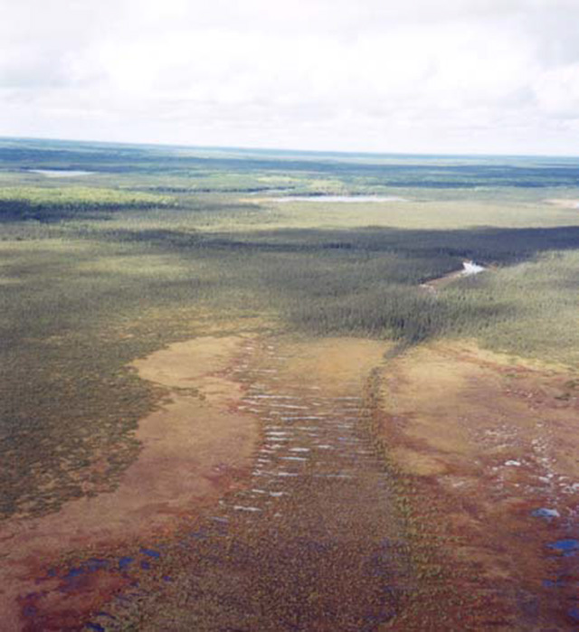
Figure 8: String bog near Piyagosksgau lake
5.1.2d Fish and wildlife
Lake surveys have been conducted on several of the mid-sized lakes including Sand, Unknown, Tomorrow, Yesterday and Today, as well as the larger Piyagaskogau, McParlon, Natogami, Edgar and Ministik lakes. The water bodies within the reserve are generally cool-water, supporting viable populations of northern pike, walleye, and yellow perch. Sturgeon and sea run (anadromou) brook char have also been reported in the area. The Wekweyaukastik and French Rivers are cold water rivers and support brook trout, walleye and northern pike. Although not confirmed through survey, some of the more northern river systems within the reserve are also expected to be cold-water bodies and brook trout angling has been reported anecdotally (Kirkbride, 2004).
The site also supports a variety of waterfowl and birds of prey including the bald eagle and osprey (Kirkbride, 2004). Wildlife populations that are known to occur within and surrounding the conservation reserve include bear, wolf, beaver, marten, otter, fisher and lynx. In addition, cougar sightings have been reported however there has been no confirmation of their existence within the area. No bear management areas currently exist within the reserve boundary however the area is overlapped by portions of nine registered traplines (Figure 9). These are CC-164, CC-199, CC-167, CC-165, CC-166, CC-163, MO-191, MO-173, and MO-174.
Figure 9: Trap line boundaries.
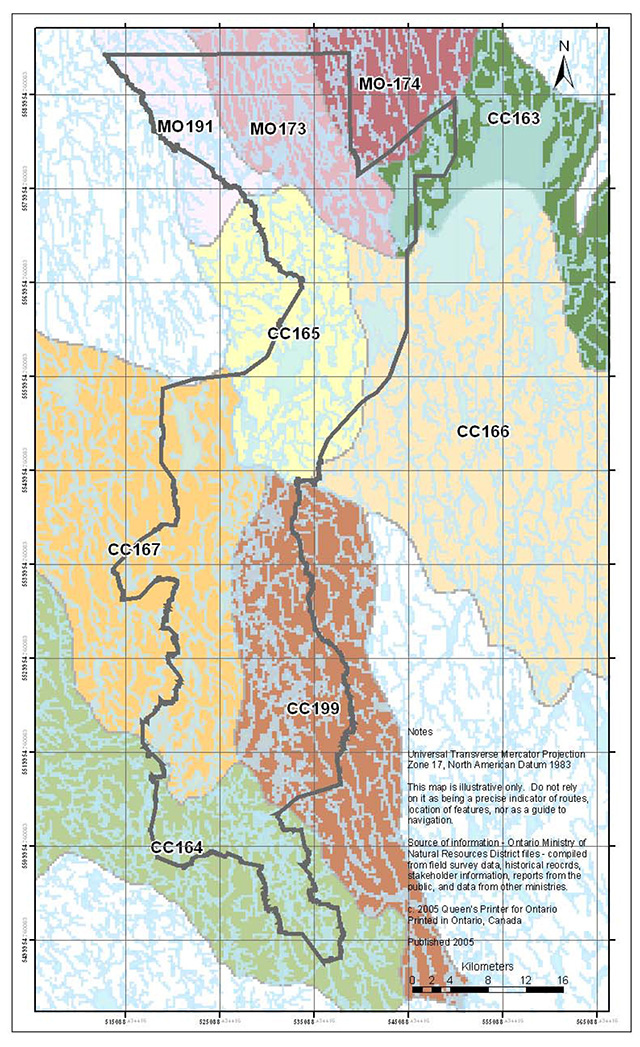
Enlarge figure 9: Trap line boundaries (PDF)
Moose also inhabit this area. Many of the wetland areas and ponds feature preferred species of aquatic vegetation which provide feeding opportunities for moose. Additionally, the area is known to contain several moose concentration areas (Kirkbride, 2004). Suitable early winter habitat for moose consists of mature or over mature mixed wood stands of relatively low stocking. Suitable early winter habitat is known to occur south of Little Wakwayowkastic Lake, through much of the middle of the conservation reserve and near Today Lake. Late winter habitat generally consists of dense stands of mature conifer with cedar, hemlock, balsam fir and white spruce being preferred over jack pine or black spruce. This type of habitat can be found in the balsam fir stands scatter through the site.
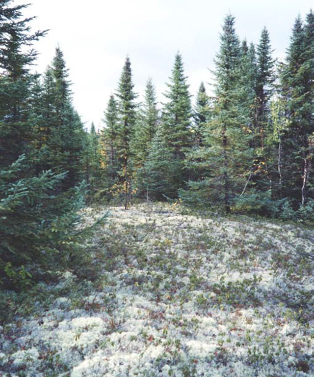
Woodland caribou, which are listed as a threatened species by the Committee on the Status of Species at Risk in Ontario (http://www.ontarioparks.com/saro-list.pdf [link updated: /page/species-risk-ontario), have also been sighted in and around the conservation reserve. Data collected in a radio telemetry study northeast of Cochrane (1998-2001) indicates that the conservation reserve provides calving areas and habitat for these caribou. As well, significant areas of lichens (Figure 10), preferred by caribou, were identified during aerial reconnaissance in 2003 (Kirkbride, 2004).
Figure 10: Lichen
5.1.3 Social values
In addition to contributing to earth and life science values to Ontario’s system of protected areas, this site is additionally important as it provides and protects recreational values, cultural values and potential research values.
5.1.3a Recreation values
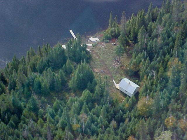
The site is relatively inaccessible to the general public, however its attraction capacity for remote recreation remains high (Kirkbride, 2004). There are currently three private recreation camps located within the conservation reserve and the site provides local users a remote protected area to enjoy outdoor activities which may include camping, hunting, fishing, nature appreciation, hiking, snow shoeing, and canoeing.
Commercial tourism is prominent in this area and operations featuring a wilderness recreation experience and remote fishing opportunities are active on 39 lakes within the reserve. Tourism operations generally include outpost cabins, privies, dock facilities and boat caches (See Figures 11 and 12). Activities at the commercial tourism camps generally focus on those related to angling or hunting with some opportunities for recreational canoeing and leisure activities such as wildlife and bird watching (Kirkbride, 2004). These commercial tourist operations also provide important economic benefit to the community. The most recent study, completed in 1997, estimated that 1,279 persons used the remote tourism facilities in the North of the North French River area in 1996. Of these visitors, approximately 30 per cent were Ontario residents while the remaining visitors were from other provinces and countries. Remote tourist clients were estimated to have spent over 1.3 million dollars in 1996. (OMNR, 1997d)
Figure 11: Example of a remote tourism outpost camp
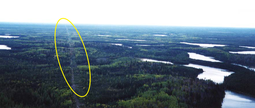
The remains of a right of way for a former transmission line traverse the extreme southern portion of the reserve. Though the transmission line has been dismantled and the area has been removed from the company’s land use permit, the area has not yet regenerated. This residual trail (Figure 13) is not maintained but is accessible by ATV from Highway 652 and provides access to the southern portion of the conservation reserve. This trail would additionally allow access to the site in the winter via snowmobile however winter activity within the conservation reserve has not yet been determined. The existence of established facilities may provide opportunities for winter recreational excursions however lack of trails and winter fishing restrictions on tourism lakes would limit activities (Kirkbride, 2004).
Figure 12: RecreationaI Values
Enlarge figure 12: RecreationaI Values (PDF)
Figure 13: Remains of hydro corridor running through south end of conservation reserve
5.1.3b First Nation values
The entire conservation reserve area lies within the traditional lands of the Moose Cree First Nation and has been identified as a principal hunting, fishing and gathering area. The area features several waterway and overland travel routes of the Moose Cree First Nation. Camp sites, portages and grave sites which are a part of family histories of the Moose Cree people are also present in the area. Current traditional activities, such as food gathering, trapping, fishing and hunting will continue to be pursued in the future.
Though the conservation reserve lies within the historical land use area of the Moose Cree First Nation, other First Nation communities have used this area as well. The Wekwayaukastic and Little Wekweyaukastik Rivers have additionally been identified as traditional canoe routes for both the Taykwa Tagamou Nation and the Wahgoshig First Nation.
5.1.3c Cultural and archeological values
Though the area has historically been used by local First Nation communities there are currently no officially registered archaeological sites within the site (Von Bitter, R. 2005)
5.1.3d Research values
No known research activities have occurred within the boundary of the North of the North French River Conservation Reserve however given the large size of the conservation reserve and low disturbance, this site would pose excellent research potential. The site should be considered as a case study in monitoring climate change, biodiversity and natural disturbance because of it’s variety of habitats and minimal human impacts (Burkhardt, 2004).
5.2 Quality of the resource
The quality of the resource or the current characteristics of the natural features found within the conservation reserve are as important as the overall representative features being protected. A number of factors are considered in evaluating a site and they include the following criteria: diversity, condition, ecological factors, special features and current land use activities.
5.2.1 Diversity
Diversity is a measure of the site’s life and earth science heterogeneity. Diversity is evaluated in terms of the variety and evenness of landform vegetation units present within the conservation reserve. Variety refers to the number of different landform vegetation units. Evenness refers to the area each landform vegetation unit covers and it is generally preferable that each landform vegetation unit is consists of roughly the same area.
The diversity rating (Thompson, 2003) states that for a site greater than 2,000 ha of this size, a site is ranked with low diversity if it has less than 25 landform units, medium if it has between 25 and 35 landform units, and high if there are more than 35 landform vegetation combinations.
The initial estimation for landform vegetation units range between 27 as a minimum to 49 depending on the data set used. In terms of evenness, communities in this site are strongly skewed. This means that the top three communities account for more than 60% of the site. In this case black spruce, treed muskeg and bog make up almost 64% of the area.
There are several features which contribute to the diversity of the site. The recent forest fires (see Section 5.2.2) provide the site with different stand development stage that is otherwise dominated by old growth. In addition, the topography, particularly the esker system, creates more forest stand diversity. The treed muskeg and open muskeg have been further classified into open, semi-tree and tree bog, string bog and poor fen as well.
The landform vegetation classification described above would indicate that this site has a medium to high diversity (depending on which landform vegetation interpretation is used). However, due to the excessively large size of this site and the strongly skewed nature of the forest communities, the diversity has been classified as low.
As previously noted (Section 5.1.1b Local Surficial Geology) research regarding the geology of the area is on-going. Once completed, a more detailed description of the landforms within the conservation reserve should be completed to confirm the number of landform vegetation units. This would allow for clarification on the number of units and additionally determine whether any of the combinations are of provincial significance.
5.2.2 Condition
Condition is the amount of disturbance that an area has experienced, whether naturally or human induced. Major natural disturbances in the Northeast Region could include fire, wind damage, floods, and insect or disease infestation. Human disturbances are wide ranging and could include activities and development relating to forestry, mining, recreation or other activities. The rating for condition is based on the amount of area currently under some form of known disturbance. A site is ranked as having a high disturbance if more than 20% of the site is disturbed, medium disturbance if 10-20% of the site is disturbed and low disturbance if less than 10% is disturbed. The ranking of pristine would apply to a site if less than 1% of the area was disturbed.
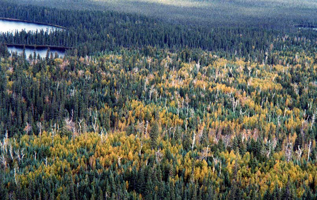
With respect to natural disturbances, several forest fires have occurred in the recent past. The largest fire to affect this conservation reserve occurred in 1995. A large block in the north end was burnt during that time and is now regenerating to jack pine (Figure 14). In 1997, a small fire occurred north of Little Wakwayowkastic Lake and east of Little Wekweyaukastik River however very little regeneration has been observed to date. Other fires that have disturbed the site are indicated in Figure 14.
Figure 14: Fire Disturbance
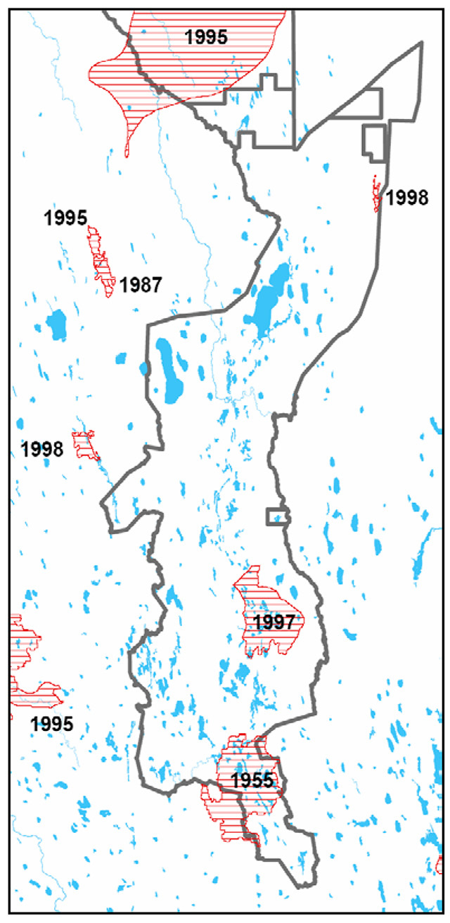
Enlarge figure 14: Fire Disturbance (PDF)
With respect to human disturbances, nearly every lake of substantial size has a camp on it. Access to these camps is by air only however, and so no road construction has disturbed the site. Another human disturbance includes the remains of a hydro corridor which runs through the southern portion of the site. This old hydro corridor is accessible by Detour Lake Road (Highway 652) and is traversable by ATV and/or snowmobiles. NRVIS (Natural Resources Values Information System) data indicates that a small network of trails or tertiary roads exist in the northern portion of the site, which were presumably used to access former mining claims. The only other known human disturbance is the remnants of an old drilling (mining) platform observed in one of the bogs.
Due to the large size of the site and the limited amount of disturbance, the site has been given an overall disturbance rating of low and is generally in good condition.
5.2.3 Ecological factors
Ecological factors refer to the design of the conservation reserve as noted by its size, shape and its ability to buffer adjacent land use activities. Larger sites are generally preferred and wherever possible, a site’s boundaries should be created to include the greatest diversity of life and earth science features. Natural features should be used to delineate boundaries where feasible to ensure that the boundaries are readily identifiable and thus prevent unintentional disturbance to the site.
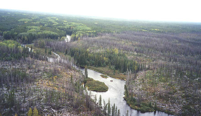
Figure 15: Natogami river, transition between burnt area (from 1995 fire) and the forest
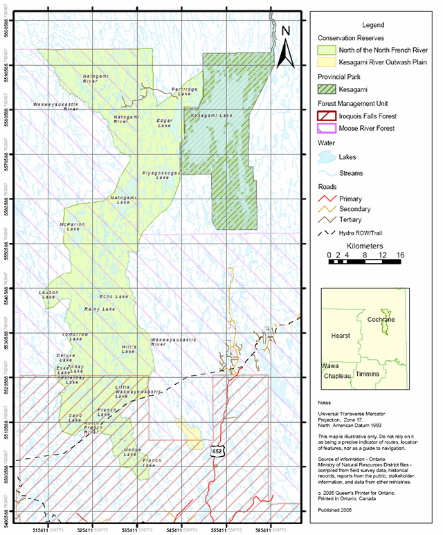
The boundaries for this conservation reserve consist of a combination of ecological, cultural and vectored boundaries. Ecological boundaries include the Wekweyaukastik River along the east and northwest boundary and numerous unnamed creeks, rivers and lakes along the west and south boundary. Cultural boundaries include the vectored boundaries of the existing Kesagami Lake Provincial Park to the northeast, the hydro corridor to the southeast and the 'Limit of Undertaking' (limit of forestry practices) in the north. The remainder of the boundary is vectored as there were no distinct natural features to use.
Currently we do not have a minimum size standard for conservation reserves however a minimum size standard of 2,000 ha has been established for natural environment parks by Ontario Parks. This minimum standard was considered necessary to protect representative landscapes as well as allow for low intensity recreational activities. The North of the North French River Conservation Reserve is over 150,000 ha which well exceeds the minimum standard. This large size serves to protect and buffer the site’s interior core values from incompatible land use activities.
The site is further protected and enhanced due to it’s linkage with the adjacent Kesagami Lake Provincial Park. These two protected areas effectively create one large area of the landscape that is free from major commercial and industrial activities that would have the potential to negatively impact their values. Limited access to the area and the identifiable natural boundaries will further reduce the risk of future disturbance to the site. Future land use planning by Moose Cree First Nation may additionally provide the opportunity to expand the conservation to the north.
5.2.4 Special features
Special features are those features that, in addition to the primary value of the site, add to the distinctiveness of a site. Examples of these features include interesting landscapes, habitats or vistas, Species at Risk (SAR) and other earth and life science features, including broader landscape elements that contribute to the natural heritage richness of Ontario.
The main feature of this site is the esker system however, additional special features includes wetland complexes of open to treed bog and string bog on lowland. Most forest communities are considered to be old growth. Additionally, the area is inhabited by several significant species including bald eagles and woodland caribou (Burkhardt, 2004).
5.2.5 Current land use activities
As previously mentioned, the quality of the representation or the current characteristics of the natural features found within the conservation reserve are as important as the overall representative features that are being protected. Land use activities can have a substantial impact on the quality of representation.
As previously described (Sections 5.1.3a) current land use activities for this conservation reserve are predominately associated with remote wilderness tourism for fishing and hunting. Other land use activities include private recreation camping, boating and trapping. In addition, the area is used by the Moose Cree First Nation communities for hunting, fishing, trapping and harvesting of food such as berries and mushrooms. The surrounding landscape is fairly intact and though commercial timber harvesting has occurred several kilometers to the south, the low and wet topography restricts that amount of forestry in the area and the interior core values should be well protected from any surrounding activities. Due to the large size of the area, human impacts to the overall site from current land use activities are minimal (Burkhardt, 2004).
6.0 Management guidelines
The management guidelines outlined in this section are intended to protect the values of the North of the North French River Conservation Reserve. These guidelines are based on policy direction contained in the OLL LUS, Conservation Reserve Policy PL 3.03.05 (OMNR, 1997a) and on the Crown Land Use Policy Atlas (CLUPA). The Cochrane Remote Wilderness (Tourism) Strategy (OMNR, 1997c) will also be considered when evaluating activities within this conservation reserve. A summary table of the management guidelines, outlining permitted uses within the site, is found in Appendix A. For an electronic version of permitted uses, please refer to the policy report found on the Crown Land Use Policy Atlas website at /page/crown-land-use-policy-atlas.
The policies indicated provide only an indication of the variety of uses that will be considered acceptable in conservation reserves. Proposed new uses and/or development, including research and education activities, will be reviewed on a case-by-case basis by Cochrane District OMNR staff. To ensure a standard screening process is followed, any new activity or development will be subject to the Class Environmental Assessment for Provincial Parks and Conservation Reserve (PPCR Class EA) (OMNR, 2004). Table 4.1 of the PPCR Class EA (Appendix 2) outlines the general screening criteria that will be applied when assessing uses or development.
The guidelines in this document are subject to change and may be amended as necessary. If a conflict exists between the different policies and guidelines, the conservation reserve will be managed to best protect the integrity of the sites natural values.
6.1 First Nations values
The North of the North French River Conservation Reserve is known to be within the traditional area of Moose Cree First Nation as described in Section 5.1.3b. Taykwa Tagamou Nation and Wahgoshig First Nation also have identified travel routes within this area.
Aboriginal rights and traditional activities, as defined by the appropriate Treaty, the Canadian Constitution and any other applicable legislation, are not affected in any way by the designation or management of this area as a provincial conservation reserve. Current traditional activities, such as trapping, hunting, fishing and food harvesting, will continue to be pursued in the future.
6.2 Cultural and archeological values
There are no known registered archaeological sites within the site (Von Bitter, R. 2005). If archaeological or cultural resources are discovered within the conservation reserve, protection and management of these values will be consistent with 'Conserving a Future for Our Past: Archaeology, Land Use Planning & Development in Ontario' (Ministry of Citizenship, Culture and Recreation (MCzCR), 1997) and the MNR-MCzCR Memorandum of Understanding for Crown Land Dispositions and Issuance of Work Permits (MCzCR, 2000).
Upon approval, the Cultural Heritage Guidelines for the Class Environmental Assessment for MNR Resource Stewardship and Facility Development Projects and for the Class Environmental Assessment for Provincial Parks and Conservation Reserves will provide the direction used to ensure protection of cultural heritage resources. (OMNR, 2004c).
6.3 Industrial activities
6.3.1 Commercial timber harvest
This conservation reserve lies within the boundaries of the Iroquois Falls Forest and the Cochrane Moose River Management Unit. Commercial timber harvest is not permitted within the boundaries of this conservation reserve.
6.3.2 Forest resource access roads
Numerous forest access roads extend north from Highway 652 to within 15 km of the conservation reserve boundary however, no forest access roads are known to exist within the boundary of the site.
It was recognized as a part of Ontario’s Living Legacy program that there was a need to balance the expansion of Ontario’s parks and protected areas network with the needs of the forest industry. In 1999, the OMNR, forest industry representatives, and the Partnership for Public Lands reached an agreement that resulted in a number of commitments contained within a document entitled the 1999 Ontario Forest Accord (OMNR, 1999b).
Commitment #20 of the Accord refers to a provision allowing the implementation of a limited number of forest access roads. In accordance with Commitment #20 of the Ontario Forest Accord, one road crossing the west boundary of the conservation reserve may be permitted. This road crossing was previously identified in the approved RWS under section 5.3 which states:
Public consultation for this road was completed during the development of the RWS and additionally as part of the consultation process for Commitment #20. In order for the road in question to be pursued it would additionally have to be approved through a forest management planning (FMP) process which would include an evaluation of alternatives and opportunities for public comment.
In the event the above describe road is constructed, a sign will be erected stating that no access to Esker, Deluxe, Yesterday, Today, Tomorrow, Sand, Unknown and Lauzon 1 Lakes is permitted for the purpose of hunting and fishing. MNR will require removal of roads and bridges when they are no longer needed by the forest industry.
Apart from the above described circumstance, forest access roads will not be permitted within the boundaries of the conservation reserve.
6.3.3 Mining and exploration
Approximately 8,000 ha of mining claims previously existed in the northern portion of this conservation reserve however, all mining claims within the site have since lapsed and been incorporated into the conservation reserve.
Mining and surface rights within the conservation reserve’s boundaries have been withdrawn from staking under the Mining Act (RSO 1990 c.M.14). Mining and mineral exploration is not permitted within the regulated boundaries of this conservation (Ontario Ministry of Northern Development and Mines, 2002)
6.3.4 Extraction of peat, soil, aggregate and other material
No extraction operations currently occur within this site. The commercial extraction of peat, soil, aggregate or other material will not permitted within the boundaries of the North of the North French River Conservation Reserve.
6.3.5 Resource extraction roads
Currently NRVIS data indicates that there is a small network of existing tertiary roads/trails in the north end of the conservation reserve. These roads were presumably used to access previous mining claims in the area which have since lapsed and been incorporated within the official boundaries of the conservation reserve.
New roads for resource extraction will not be permitted. Existing roads will be permitted to continue however maintenance of the roads will not be permitted.
6.3.5 Energy generation
No energy generation facilities exist within the conservation reserve. New energy generation facilities, including hydropower development or wind power generation operations will not be permitted.
6.3.6 Transmission corridors
Energy transmission corridors will generally not be permitted within the boundaries of the conservation reserve however it is recognized that this site has previously been impacted by a transmission corridor. It is the intent to actively discourage transmission corridors, but it is recognized that in some circumstances there will be no viable alternatives. In the event there are no viable alternatives, proposals will be subject to the PPCR Class EA. Any proposed new corridors should follow previously disturbed areas where possible and should be designed to avoid key values of the site, as described in Section 5.
6.3.7 Communication corridors
There are currently no communication corridors within the North of the North French River Conservation Reserve. Communication corridors will generally not be permitted within the boundaries of this conservation reserve however it is recognized that this site has previously been impacted by a transmission corridor. It is the intent to actively discourage these uses, but it is recognized that in some circumstances there will be no viable alternatives. In the event there are no viable alternatives, proposals will be subject to the PPCR Class EA. Any proposed new corridors should follow previously disturbed areas where possible and should be designed to avoid key values of the site, as described in Section 5.
6.4 Commercial activities
6.4.1 Commercial bait harvesting
No commercial bait harvesting operations currently exist within the site. New operations may be considered subject to the PPCR Class EA and would additionally consider any required new trails during evaluation of the proposal.
6.4.2 Commercial fishing
There are currently no commercial fisheries operating within the conservation reserve. New operations may be considered subject to the PPCR Class EA.
6.4.3 Commercial fur trapping
Commercial fur trapping is an existing use within this conservation reserve and currently, portions of 9 traplines overlap this conservation reserve. These include CC-164, CC-199, CC-167, CC-165, CC-166, CC-163, MO-191, MO-173, and MO-174, all of which are permitted to continue.
In the event that a head trapper surrenders a registered trapline, or the head trapper’s privileges are revoked, the registered trapline may be transferred to another trapper following established allocation procedures. If the registered trapline is not transferred in due course, or remains unallocated for a significant period of time, reallocation of the trapline may occur. MNR will first offer a vacant trapline to the First Nation family who traditionally held the trapline. In the event that the First Nation family does not wish the trapline, the trapline would be allocated following the applicable district screening processes.
New operations can be considered, subject to the PPCR Class EA. As part of the determination of whether new trapping activities would be permitted, the associated trails that would be required must also be considered during the screening of the proposal.
There are currently no trap cabins located with the boundaries of the North of the North French River Conservation Reserve. New trap cabins will not be permitted within the boundaries of this site.
6.4.4 Bear management areas
No bear management areas (BMA) are associated with this conservation reserve. The policy regarding BMA's states that the issuance of Licences to Provide Bear Hunting Services will be allowed where areas have been licensed or authorized under agreement for the activity since January 1, 1992. (OMNR 2003) As no BMA's have ever been issued in this area, new bear management areas will not be permitted in this conservation reserve.
6.4.5 Commercial harvesting of food
There are currently no commercial food harvesting activities, including harvesting of wild rice. Commercial food harvesting may be permitted within the conservation reserve, subject to the PPCR Class EA. Associated access requirements must also be considered during the screening of the proposal.
6.4.6 Commercial harvesting of non-timber forest products
Currently, there are no known commercial harvesting activities of non-timber forest products (e.g. Canada Yew). Commercial harvesting of non-timber forest products may be permitted within the conservation, subject to the PPCR Class. Associated access requirements must also be considered during the screening of the proposal.
6.4.7 Outpost camps/main base lodges
Currently there are 39 existing authorized outpost camps that feature a wilderness recreation experience and remote fishing opportunities within the conservation reserve. Operations generally include shore land outpost cabins or sites, privies, dock facilities and boat caches. Operations are authorized under an Land Use Permit (LUP).
Existing authorized tourism facilities can continue unless there are significant demonstrated conflicts. The operators of tourism facilities can apply to upgrade tenure from LUP to lease but sale of land will not be permitted. Requests may be considered subject to the PPCR Class EA. All current rents, taxes, fees, rates or charges, must be paid for the request to be considered.
New outpost camps and main base lodges may be considered but will be subject to the PPCR Class EA.
6.5 Recreational and non-commercial activities
6.5.1 Low-impact recreation activities
Hiking, cross-country skiing, snow-shoeing, and other non-motorized activities will be permitted within this conservation reserve. Should the impact of these activities degrade the landscape, the Ministry of Natural Resources will re-evaluate these permitted uses and decide upon a new strategy for this site. New trails to support these activities may be considered however will be developed with consultation and with a priority on ensuring the remote nature of the site. Please refer to subsection 6.6.3 - Trails for more details related to trail development.
6.5.2 Camping
There are no maintained campsites or campgrounds within this conservation reserve. Crown land camping is permitted subject to the appropriate policies, unless significant adverse effects on protected values necessitate further planning and management for this activity. Any existing traditional campsites should be used to avoid disturbance of new areas within the conservation reserve.
6.5.3 ATV and snowmobile use
Access to the conservation reserve by ATV or snowmobile is permitted. There are no established trails within the conservation reserve however the continued use of traditionally used trails is permitted. Off-trail use of ATVs and snowmobiles is generally not permitted. Hunters are allowed off-trail ATV and snowmobile use for the direct retrieval of large game only. Should the impact of ATV and snowmobile use degrade the landscape the Ministry of Natural Resources will re-evaluate these permitted uses and determine a new strategy.
6.5.4 Private recreation camps
Currently there are three private recreation camps that exist within the conservation reserve. These private recreation camps are permitted to continue. Requests for transfers may be considered subject to the PPCR Class EA.
Those occupants currently holding a LUP for their private recreation camp may apply to upgrade to enhanced tenure.
"Enhanced tenure" is defined as an upgrade in the nature or type of tenure (e.g. from a LUP to a lease), and/or an extension in the term of the tenure (e.g. from 1 year to 10 years). (OMNR, 2000). Sale of land within the conservation reserve for private recreation camps will not be permitted. Enhanced tenure is not guaranteed. If lands were needed to protect significant natural or recreational values, enhanced tenure would not be granted. Granting of enhanced tenure does not convey a commitment to provide for a change in the type or the standard of existing access to the private recreation camp.
Requests for enhanced tenure may be considered subject to the PPCR Class EA. All current rents, taxes, fees, rates or charges, must be paid for the request to be considered.
6.5.5 Private access roads
There are currently no private access roads located within the conservation reserve. New private access roads will not be permitted.
6.5.6 Hunting and fishing
In conjunction with current hunting regulations for Wildlife Management Unit 12, hunting is permitted to continue within the conservation reserve.
Recreational fishing is also permitted to continue in compliance with current fishing regulations. This includes the prohibition of winter fishing (November 1 to May 14) on identified tourism lakes within the conservation reserve. Users of the area are responsible for ensuring they follow the most up to date hunting and fishing regulations which are available at all Ministry of Natural Resource offices.
6.5.7 Cutting of trees for non-commercial purposes
Cutting of trees for non-commercial purposes may be authorized by the OMNR, subject to the PPCR Class EA. Such permits are intended only for leaseholders, LUP holders, cottagers and other property owners within the conservation reserve who do not have road access to their property and who do not have an alternate wood source outside of the conservation reserve. The allowance to cut trees within a conservation reserve is intended to cover fuelwood, dock stringers, and other occasional small-scale uses.
6.5.8 Non-commercial food harvesting
Non-commercial food harvesting such as harvesting of berries and mushrooms can occur provided the values of the site, identified in section 5.0- State of the Resource, are not jeopardized.
6.6 Roads and trails
6.6.1 Roads
The nearest all-weather road is Highway 652, approximately 15 km southeast of the reserve boundary. The only roads known to exist within the site is small network of tertiary roads/trails located in the north of the conservation reserve.
Generally, new roads and transportation corridors are not permitted within the boundaries of the conservation reserve. For information on resource extraction roads, please see section 6.3.5, or section 6.3.2 for forest resource access roads.
6.6.2 Trails
Under Ontario Regulation 453/96 (OMNR 2003b), a trail is defined as "a path over public lands not used for mineral exploration or extraction." A trail is minor in nature compared to a road, allowing passage of pedestrians, ATVs, snowmobiles or the like.
New trails may be considered however any proposed new trails or development of existing trails are subject to the PPCR Class EA and applicable Ministry of Natural Resources' policies and procedures. Proposed trail development must take into account the characteristics of this site and must be compatible with the site’s key values, including the remote nature of the site.
If new trails are approved, trail heads and trail routes must be recorded using new technologies (i.e. global positioning systems) to ensure an accurate record of the location of the feature.
Minor maintenance (as defined under Policy PL 3.03.04 [OMNR 2003b]) of existing trails will be permitted provided that maintenance activities do not negatively impact the values being protected by the conservation reserve. Trail maintenance will be subject to the PPCR Class EA.
6.7 Land disposition
The sale of land within the conservation reserve is not permitted. The disposition of small parcels of land for some types of minor exceptions may be permitted (i.e. to provide adequate area for the installation of a septic system), provided it does not detrimentally affect the key values of the site. Such dispositions will be screened through the PPCR Class EA.
6.8 Resource management activities
Resource management activities refer to those tools used to protect and enhance the values of this conservation reserve. Some management activities may require the use of intrusive techniques. Under normal circumstances, some of these techniques would not be permitted to occur in the conservation reserve; however, if they are found to be necessary, they may be applied under controlled conditions, to achieve a desired result. Infrastructure such as roads, trails and buildings may need to be constructed to support activities such as prescribed burns, forest regeneration, wildfire control, and insect and disease control. Any of these activities will be subject to PPCR Class EA to ensure compliance with the direction and management of the conservation reserve.
6.8.1 Insect and disease control
This conservation reserve will be maintained in as natural a state as possible. Measures may be taken to control the outbreak or infestation of insects and diseases which threaten significant heritage, aesthetic or economic values. Insect and disease control measures should only be considered if the identified values of the conservation reserve or adjacent forest values on Crown land are significantly threatened. If such measures are proposed, they will be subject to screening under the PPCR Class EA. Native biological control will be used wherever possible.
6.8.2 Exotic and/or invasive species
The deliberate introduction of exotic and/or invasive species will not be permitted. Where the establishment of a non-native plant species is identified and threatens the values in the conservation reserve, a strategy may be developed to control the species and will be subject to screening under PPCR Class EA.
6.8.3 Fish and wildlife management
Fish and wildlife resources, including the management of endangered or threatened species, will continue to be managed in accordance with specific policies and regulations applicable to the area. New fish and wildlife management activities (e.g., fish stocking, habitat enhancement/ rehabilitation, population control) may be considered but will be subject to screening under the PPCR Class EA.
6.8.4 Vegetation management
There are currently no vegetation management activities within the conservation reserve. Vegetation management activities may be considered to address man-made disturbance within the conservation reserve however vegetation loss due to natural processes such as wind, fire or insect damage will be left to regenerate naturally and will not be considered for management activities.
Any proposal for vegetation management would be subject to the PPCR Class EA and would require the development of a separate vegetation management plan. This separate vegetation plan would consider the restoration ecology objective (e.g. representation) for the area within the ecodistrict context, any applicable current provincial strategies as well as the objectives for both the conservation reserve and surrounding landscape.
Any completed vegetation management plan would be included as an amendment to this document.
6.8.4 Fire management
The MNR recognizes fire as an essential process fundamental to the ecological integrity of conservation reserves. In accordance with existing Conservation Reserve Policy and the Forest Fire Management Strategy for Ontario, forest fire protection will be carried out as on surrounding lands.
The Fire Management Planning Guidelines for Provincial Parks and Conservation Reserves (OMNR, 2004b) and the Forest Fire Management Strategy for Ontario provides direction on fire response and fire use.
Opportunities for prescribed burning to achieve ecological or resource management objectives may be considered. These management objectives will be developed with public consultation prior to any prescribed burning, and reflected in the document that provides management direction for this conservation reserve. Plans for any prescribed burning will be developed in accordance with the MNR Prescribed Burn Planning Manual, and the Class Environmental Assessment for Provincial Parks and Conservation Reserves.
Whenever feasible, the MNR fire program will endeavor to use "light on the land" techniques, which do not unduly disturb the landscape, in this conservation reserve. Examples of light on the land techniques may include limiting the use of heavy equipment or limiting the number of trees felled during fire response efforts.
6.8.6 Forest renewal
Forest renewal is an activity generally associated with commercial timber harvest. Such activities would be considered if the area within the conservation reserve had been recently cut prior to becoming regulated. However, no areas within this conservation reserve are known to have been recently harvested indicating that forest renewal is currently not required. In the future, should unauthorized forest harvest occur within the boundaries of the conservation reserve, forest renewal will be considered.
Forest renewal may additionally be considered to address other man-made disturbance within the conservation reserve however forest lost due to natural processes such as wind, fire or insect damage will be left to regenerate naturally and will not be considered for forest renewal. Forest renewal may be permitted subject to the PPCR Class EA, although natural regeneration will be the preferred option. Associated vegetation management programs to enhance forest renewal may also be considered subject to the PPCR Class EA and guidelines outlined in section 6.8.4 of this document.
6.9 Research
No existing research activities have been identified within this site.
Scientific research by qualified individuals or institutions is encouraged, especially if the research contributes to a better understanding of the natural and cultural values protected by this conservation reserve. Proposals to conduct research, inventory, monitoring and/or assessment activities that are compatible with protection objectives must be submitted in writing to the Iroquois Falls Area Supervisor, Cochrane District. Proposal will be subject to the PPCR Class EA, the Procedural Guideline C – Research Activities in Conservation Reserves (Appendix B), and any other relevant Ministry of Natural Resources' policies, procedures and conditions. Permits for removal or collection of any natural or cultural specimens by a qualified researcher may be issued, on a case by case basis as a part of authorized research project and will be subject to appropriate permits and conditions. All such materials removed remain the property of the OMNR. Researchers will also submit copies of reports, publications and theses following the results to the Area Supervisor.
New developments required for research activities such as campsites, privies, sample plots, observation station or associated trails may be considered and will be subject to screening through the PPCR Class EA. Any area that is disturbed during research activities will be required to be rehabilitated as closely as possible to its original condition.
7.0 Recommendations
It is recognized that not all features or uses occurring within the North of the North French River Conservation Reserve have been identified during the current planning process. Future activities which should be considered to better develop our understanding of the natural features protected by this conservation reserve are as follows:
- Further life science analysis and assessment should be conducted to determine if additional management prescription are required to ensure long-term protection of the site’s natural heritage values
- Current, on-going earth science related work should be completed in order provide additional information regarding the earth science values and life science values (i.e. landform vegetation units)
- Areas of high cultural and archaeological potential should be assessed through the proper archaeological methods as funding permits
- Winter use should be assessed; and
- The public should be educated about the key values in this site and how their activities may impact sensitive features within the conservation reserve
8.0 Implementation, marketing, review and revisions
8.1 Implementation and marketing
The Iroquois Falls Area team will be the lead team responsible for implementing the management policies and guidelines for the North of the North French River Conservation Reserve. Additionally, staff from the Cochrane District Enforcement team may be responsible for assisting with compliance monitoring.
Though no active marketing of this conservation reserve is anticipated at this time information regarding this site will be available at the Cochrane District Ministry of Natural Resources.
8.2 Review and revisions
Changes in management direction or policy may be required as additional information is collected about the conservation reserve and the natural heritage values it protects. This ESCI will be updated as information become available. As a minimum, this ESCI will be reviewed every five years by the District Planner in Cochrane District MNR to confirm and update the information in this document.
If changes in management direction are needed at any time, the significance of the changes will be evaluated. Minor changes that do not alter the overall protection objectives may be considered and approved by the Area Supervisor and District Manager as a minor amendment without further public consultation. All minor amendments to the SCI will be documented in Appendix F. In assessing major changes, the need for a more detailed Resource Management Plan (RMP) will first be considered. Where a RMP is not considered necessary or feasible, a major amendment to management direction may be considered with public consultation. Major amendments will be recommended by the District Manager and approved by the Regional Director.
The Crown Land Use Policy Atlas and associated website will be amended to reflect any change in management direction and all amendments will be appended to this ESCI in Appendix F.
References:
Barbara Burkhardt, Lori King, Angie Schultz. 2004. North of the North French River Conservation Reserve Life Science Checksheet –Step 2. Unpublished Information. Ontario Ministry of Natural Resources.
Crins, W.J. and Uhlig, P.W.C. 2000. Ecoregions of Ontario: Modification to Angus Hills' Site Regions and Site Districts – Revisions and Rationale.
Cudmore, W. 2004. Personal correspondence.
Hills, G. A. 1959. A Ready Reference for the Description of the Land of Ontario and its Productivity. Preliminary Report. Ontario Department of Lands and Forests. Maple. Ontario.
http://atlas.gc.ca/site/english/maps/environment/land/surficialmaterials/1 [link no longer active]
http://www.cfl.scf.rncan.gc.ca/ecosys/classif/intro_regions_e.asp [link no longer active]
http://www.ontarioparks.com/saro-list.pdf [link updated: /page/species-risk-ontario]
http://www.ontariogazette.gov.on.ca/
Kirkbride, M. 2004. North of the North French River Conservation Reserve Recreation Inventory Report. Ontario Ministry of Natural Resources.
Kristjansson, R.J. 2004. Earth Science Inventory Checklist for C1606 North of the North French River Conservation Reserve. Unpublished Information. Ontario Ministry of Natural Resources.
Ministry of Citizenship, Culture and Recreation 1997. Conserving a Future for Our Past: Archaeology Land Use Planning and Development in Ontario, Section 3.
Ministry of Citizenship, Culture and Recreation. 2000. MNR-MCzCR Memorandum of Understanding for Crown Land Dispositions and Issuance of Work Permits, Screening for Cultural Heritage Resources.
Ontario Ministry of Natural Resources. 1983. Cochrane District Land Use Guidelines.
Ontario Ministry of Natural Resources. 1997a. Conservation Reserves Policy PL 3.03.05.
Ontario Ministry of Natural Resources, 1997b. Conservation Reserve Procedure PL 3.03.05.
Ontario Ministry of Natural Resource. 1997c. Approved Cochrane District Remote (Wilderness) Tourism Strategy. Cochrane District, Ontario District Ministry of Natural Resources.
Ontario Ministry of Natural Resource. 1997d. An Economic Analysis and Evaluation of the North of the North French River Area Default Management Option. Analysis and Planning Service Section, Land Use Planning Branch. Ontario Ministry of Natural Resources.
Ontario Ministry of Natural Resources. 1997e. Prescribed Burn Planning Manual. AFFMB Publication No. 313. Ontario Ministry of Natural Resources.
Ontario Ministry of Natural Resources. 1999a. Ontario’s Living Legacy Land Use Strategy. Queen’s Printer for Ontario, Ontario, Canada.
Ontario Ministry of Natural Resources. 1999b. Ontario Forest Accord "A Foundation for Progress". Queen’s Printer for Ontario, Ontario, Canada
Ontario Ministry of Natural Resources. 2000. Conservation Reserve Policy-As Amended by the Ontario Living Legacy Land Use Strategy. Unpublished document.
Ontario Ministry of Natural Resources. 2001. Procedures for the Amendment of Ministry of Natural Resources Land Use Direction. Ontario Ministry of Natural Resources.
Ontario Ministry Natural of Resources. 2003a. Direction for Commercial Resource Use Activities in Provincial Parks and Conservation Reserves. June 2003.
Ontario Ministry Natural of Resources. 2003b. Public Lands Act Work Permit (Section 14). Policy PL 3.03.04.
Ontario Ministry of Natural Resources. 2004a. A Class Environmental Assessment for Provincial Parks and Conservation Reserves. Queen’s Printer for Ontario, Ontario, Canada.
Ontario Ministry of Natural Resources. 2004b. Fire Management Policy for Provincial Parks and Conservation Reserves. Queen’s Printer for Ontario, Ontario, Canada.
Ontario Ministry of Natural Resources. 2004c. Draft Cultural Heritage Guidelines for the Class environmental Environmental Assessment for MNR Resource Stewardship and Facility Development Projects and for the Class Environmental Assessment for Provincial Parks and Conservation Reserves.
Ontario Ministry of Natural Resources. Crown Land Use Atlas. Accessed 2005. http://crownlanduseatlas.mnr.gov.on.ca/policylists/co.html [link updated: /page/crown-land-use-policy-atlas]
Ontario Ministry of Northern Development and Mines. March 15, 2002. Letter to Ministry of natural Resources regarding Revised Policy on mineral exploration in new parks and conservation reserves.
Ontario Parks. 2004. Representing Ontario’s Ecosystems. Queens Printer for Ontario.
Rowe, J.S. 1972. Forest regions of Canada. Dept. of Fisheries and the Environment. Canadian Forestry Service. Publication No. 1300. 172 pp.
R.S.O. 1990, Chapter E.18. Environmental Assessment Act http://www.e-laws.gov.on.ca/DBLaws/Statutes/English/90e18_e.htm [link no longer active]
Thompson, J. 2001. Northeast Region Guidelines on the Planning Process for Conservation Reserves: Statements of Conservation Interest and Resource Management Plan. Unpublished Information. Ontario Ministry of Natural Resources.
Thompson, J., Noordhof, J. 2003. Edit Model for N.E. Region Life Science Checksheets. Internal Report.
Von Bitter, R. 2005. Ministry of Culture, Database Coordinator Personal correspondence.
Appendix A: Permitted use tables
Appendix B: Screening table from PPCR Class EA
Table 4.1 Screening Criteria of the Class Environmental Assessment for Provincial Parks and Conservation Reserves
| Screening Criteria "This project may affect …" |
- H | - M | - L | Nil | Unk | + L | + M | + H | Comments, Rationale |
|---|---|---|---|---|---|---|---|---|---|
| Values for which the provincial park or conservation reserve was established |
Natural environment considerations
| Screening Criteria "This project may affect …" |
- H | - M | - L | Nil | Unk | + L | + M | + H | Comments, Rationale |
|---|---|---|---|---|---|---|---|---|---|
| Air quality | |||||||||
| Water quality or quantity (ground or surface) | |||||||||
| Species at risk or their habitat | |||||||||
| Significant earth or life science features | |||||||||
| Fish or other aquatic species, communities, or their habitat (including numbers, diversity and movement of resident or migratory species) | |||||||||
| Land subject to natural or human-made hazards | |||||||||
| Recovery of a species under a special management program (e.g. elk restoration) | |||||||||
| Ecological integrity | |||||||||
| Terrestrial wildlife (including numbers, diversity and movement of resident or migratory species) | |||||||||
| Natural vegetation and terrestrial habitat linkages or corridors through fragmentation, alteration and/or critical loss | |||||||||
| Permafrost | |||||||||
| Soils and sediment quality | |||||||||
| Drainage or flooding | |||||||||
| Sedimentation or erosion | |||||||||
| Release of contaminants in soils, sediments | |||||||||
| Natural heritage features and areas (e.g. areas of natural and scientific interest, provincially significant wetlands) | |||||||||
| Other (specify) |
Land use, resource management considerations
| Screening Criteria "This project may affect …" |
- H | - M | - L | Nil | Unk | + L | + M | + H | Comments, Rationale |
|---|---|---|---|---|---|---|---|---|---|
| Remoteness (access inaccessible areas) | |||||||||
| Navigation | |||||||||
| Other projects within a park or reserve | |||||||||
| Other projects outside a park or reserve | |||||||||
| Traffic patterns or traffic infrastructure | |||||||||
| Public or private recreation | |||||||||
| Or create excessive waste materials | |||||||||
| Or commit a significant amount of a non-renewable resource (e.g. aggregates, agricultural land) | |||||||||
| Noise levels | |||||||||
| Views or aesthetics | |||||||||
| Another project, or be a precondition or justification for implementing another project | |||||||||
| Uses, persons or property outside a park or reserve | |||||||||
| Other (specify) |
Social, cultural, and economic considerations
| Screening Criteria "This project may affect …" |
-H | -M | -L | Nil | Unk | +L | +M | +H | Comments, Rationale |
|---|---|---|---|---|---|---|---|---|---|
| Archaeology | |||||||||
| Built heritage | |||||||||
| Cultural heritage landscapes | |||||||||
| Sacred or traditional use sites | |||||||||
| Or displace people, businesses, institutions, or public facilities | |||||||||
| Community character, enjoyment of property, or local amenities | |||||||||
| Demands on government services or infrastructure | |||||||||
| Public health and/or safety | |||||||||
| Local, regional or provincial economies or businesses | |||||||||
| Tourism values (e.g. resource-based tourist lodge) | |||||||||
| Other (specify) |
Aboriginal considerations
| Screening Criteria "This project may affect …" |
-H | -M | -L | Nil | Unk | +L | +M | +H | Comments, Rationale |
|---|---|---|---|---|---|---|---|---|---|
| First Nation reserves or communities | |||||||||
| Spiritual, ceremonial, or cultural sites | |||||||||
| Traditional land or resources uses, or affect economic activities | |||||||||
| Aboriginal values | |||||||||
| Lands subject to land claims | |||||||||
| Other (specify) |
Appendix C: Procedural guidelines C – Research activities in conservation reserves
Procedural guidelines C – Research activities in conservation reserve
Conservation Reserve Policy Procedure PL. 3.03.05
Purpose
To encourage contributions to the goal of the conservation reserves by:
- Providing direction for research activities associated with the conservation reserves; and
- Establishing a process for the review and approval of proposals by researchers, which could have an impact on the values protected by the conservation reserve
Definition
Research means any investigation or study of the natural, cultural, social, economic, management or other features or characteristics of conservations reserves.
Guidelines
Research will be encouraged to provide a better understanding of the natural values protected by a conservation reserve and to advance their protection, planning and management.
The Statement of Conservation Interest will define, for each conservation reserve, the key research issues, set out the parameters within which research may occur and identify research needs.
Applications and approvals
Researchers must apply in writing to the Area Supervisor for permission to conduct research. The request letter must contain a statement explaining why the proposed research should be undertaken in the particular conservation reserve in preference to another location.
Proposals will be reviewed and approved by the Area Supervisor, guided by the Statement of Conservation Interest prepared for each reserve, including adherence to the Class Environmental Assessment for Provincial Parks and Protected Areas. Permission must be granted in writing, including any conditions to be met in conducting the research prior to the undertaking of any research project.
Terms and conditions
Permission to conduct research under this policy will be valid for a period of 12 consecutive months from date of issue. Permission to continue a research project for addition periods of 12 months or less may be granted upon submission of a written request and progress report. The Ministry may require the posting of collateral to assure that the terms and conditions of granting permission are met.
The Area supervisor may suspend or revoke permission at any time for failure on the part of the researcher to meet:
- The intent or conditions of this policy
- The requirements under the Public Lands Act, including all amendments, where applicable
- The requirements under any other Act or Regulations of Ontario or Canada, including those governing the taking, handling, storing, confining, trapping, excavating and marketing any specimen, artefact, information or action (for example, scientific collector’s permit)
- The condition and agreement specified in granting permission
Final report
The researcher will submit copies of reports, publication and theses following from the results of the project to the Area Supervisor.
Appendix D: Earth science maps
C1606 North of the North French River CR - Map 1 of 2
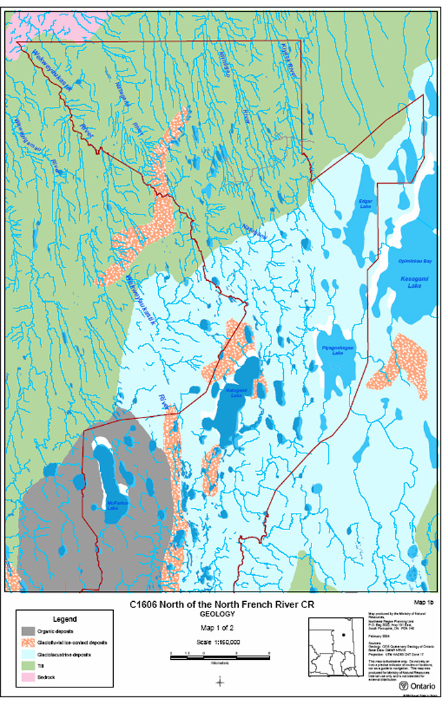
Enlarge C1606 North of the North French River CR - Map 1 of 2 (PDF)
C1606 North of the North French River CR - Map 2 of 2
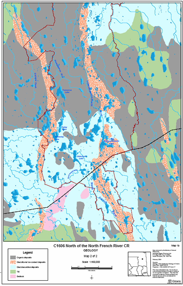
Enlarge C1606 North of the North French River CR - Map 2 of 2 (PDF)
Appendix E: Life science maps
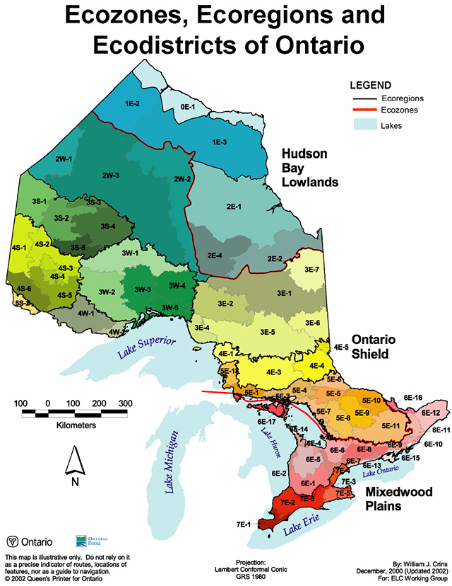
Enlarge Ecozones, Ecoregions and Ecodistricts of Ontario (PDF)
Forest Communities Map 1 of 2
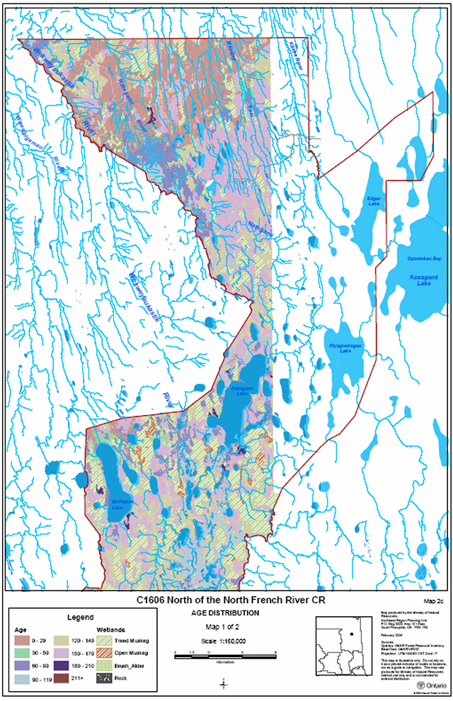
Enlarge Forest Communities Map 1 of 2
Forest Communities Map 2 of 2
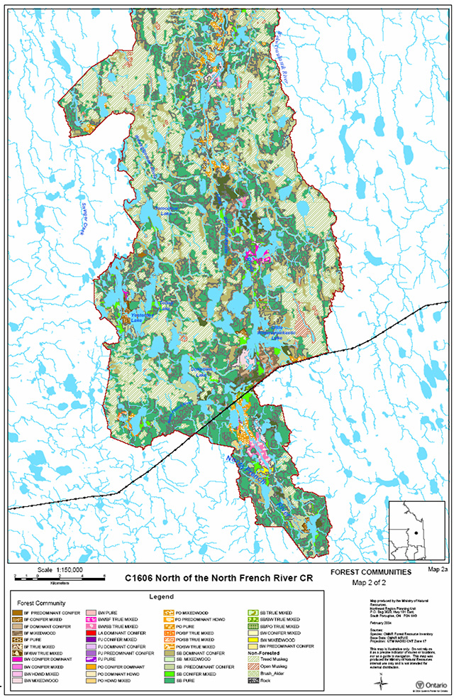
Enlarge Forest Communities Map 2 of 2 (PDF)
Age Distribution Map 1 of 2
Enlarge Age Distribution Map 1 of 2
Age Distribution Map 2 of 2
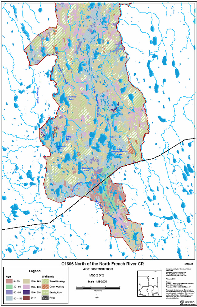
Enlarge Age Distribution Map 2 of 2
Wetlands map 1 of 2
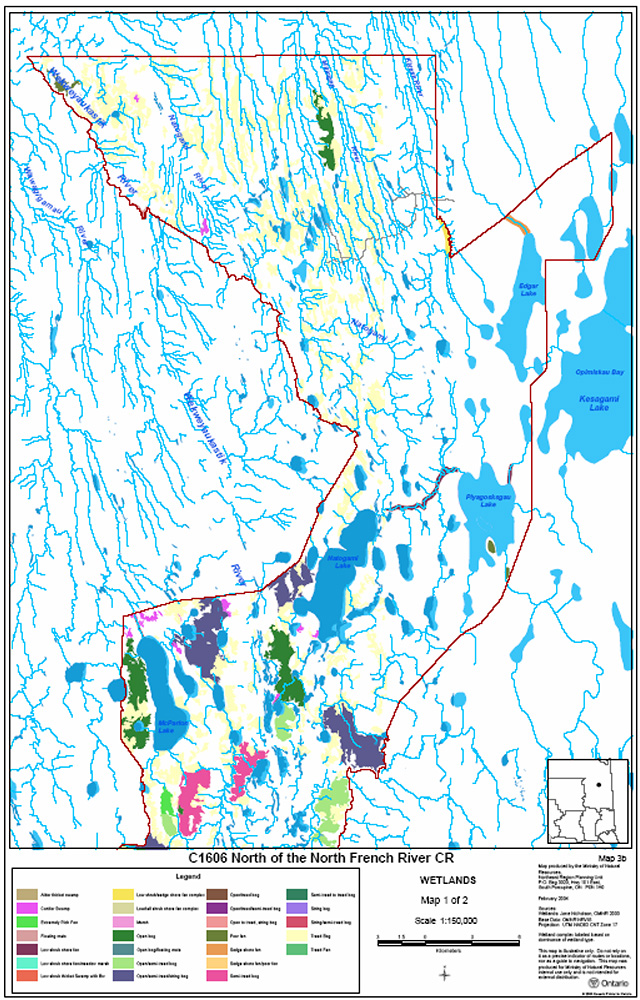
Wetlands map 2 of 2