North Thornben Lake Moraine Conservation Reserve Management Statement
This document provides policy direction for the protection, development and management of the North Thornben Lake Moraine Conservation Reserve and its resources.
C1510 North Thornben Lake Moraine Conservation Reserve
Statement of Conservation Interest
December 2004
Prepared by: Angela Anderson
Revised: February 2005
Wawa District
Approval statement
We are pleased to approve this Statement of Conservation Interest (SCI) for the North Thornben Lake Moraine Conservation Reserve (C1510). Direction for the establishment, planning and management of conservation reserves is defined under the Public Lands Act and the Crown Land Use Policy Atlas.
North Thornben Lake Moraine Conservation Reserve is located approximately 50 km northwest of the town of Hornepayne. The conservation reserve (CR) has an area of 454 hectares and is located on top of a flat end moraine deposit. The CR is within the Big Pic River Forest Management Unit in the Wawa District.
The public was invited to comment on the proposed boundary of North Thornben Lake Moraine CR in September 2000. The site was then regulated as a conservation reserve on May 21, 2003. The public will be invited to comment on this draft SCI in 2005. Comments and concerns registered will be reflected in the final Statement of Conservation Interest. A final inspection opportunity will be provided for the public to review the approved SCI document. This document was prepared by an interdisciplinary planning team having expertise in forest ecology, biology, land management, and fire management. A draft was provided to the MNR Regional Planning Unit for review.
This Basic SCI provides guidance for the management of the North Thornben Lake Moraine Conservation Reserve and provides the basis for the ongoing monitoring of activities. More detailed direction is not anticipated at this time. Should significant facility development be considered or complex issues arise requiring additional studies, more defined management direction, or special protection measures, a more detailed Resource Management Plan will be prepared with full public consultation.
The North Thornben Lake Moraine Conservation Reserve is managed under the jurisdiction of the District Manager and the Manitouwadge Area Supervisor, Wawa District, Ministry of Natural Resources.
Submitted by:
Original signed by Paul Gamble for Angela Anderson
Plan Author
Date: February 25, 2005
Original signed by Terry Taylor
District Manager Recommendation for Approval
Date: February 25, 2005
Approved by:
Original signed by Rob Galloway
Regional Director/Northeast Region
Date: April 10, 2005
1.0 Introduction
The purpose of this Statement of Conservation Interest (SCI) is to identify and describe the values of the North Thornben Lake Moraine Conservation Reserve. The SCI also outlines the activities that occur within the conservation reserve (CR) and provides guidelines for the management of current and future activities in the context of protecting the natural, social and cultural values of the conservation reserve. A SCI is prepared under the authority of Procedural Guideline A – Resource Management Planning (PL Procedure 3.03.05) of the Public Lands Act.
Ontario’s Living Legacy Land Use Strategy (1999) and the Crown Land Use Policy Atlas (updated 2004) outline the general land use policy and management direction for new conservation reserves. Each new conservation reserve will have a planning document, either a SCI or, in more complex situations a Resource Management Plan, that details site-specific management direction.
This Basic SCI provides guidance for the management of the North Thornben Lake Moraine Conservation Reserve and provides the basis for ongoing monitoring of activities. Although more detailed direction is not anticipated at this time, should significant facility development be considered or complex issues arise requiring additional studies, more defined management direction, or special protection measures, a more detailed Resource Management Plan will be prepared with full public consultation.
Conservation reserves protect natural heritage values on public lands while permitting compatible land use activities. By allocating these lands to the parks and protected areas system through regulation, the province has ensured a certain level of permanence by distinguishing the conservation reserve and its values from the larger general use or more extensively managed landscape. In addition, the conservation reserve’s natural features are, and will be available for present and future generations to enjoy and explore.
Ontario’s Living Legacy Land Use Strategy was approved in 1999. The objectives of the Land Use Strategy are to complete Ontario’s system of protected areas; recognize the land use needs of resource-based tourism industry; provide forestry, mining and resource industries with greater certainty around land and resource use; and enhance hunting, angling and other Crown Land recreational opportunities. North Thornben Lake Moraine Conservation Reserve was created as part of the expansion of protected areas.
North Thornben Lake Moraine is a 454 hectare conservation reserve located 55 kilometres northeast of the town of Manitouwadge and 55 km northwest of the town of Hornepayne. The boundary falls within the Big Pic Forest Management Unit, Wawa District where there are no surveyed townships (Appendix 8.1). The site is a representation of a moderately broken end moraine, lacustrine (lake) deposits and mixed deciduous coniferous forest. The site also encompasses some headwaters feeding into the Osawin River.
2.0 Goals and objectives
2.1 Goals of Statements of Conservation Interest
The goals of this SCI are:
- To provide background information
- To identify and describe the values of the conservation reserve
- To provide guidelines for the management of current and future activities while protecting natural, social and cultural heritage values
2.2 Objectives of Statements of Conservation Interest
The following objectives are identified as a means to achieve the above goals.
- To describe the state of the resource with respect to natural heritage values and current land use activities
- To manage the conservation reserve to protect the integrity of its natural values via specific guidelines, strategies and prescriptions
- To meet planning requirements by addressing the management intent of the conservation reserve and addressing planning and management needs
- To create a public awareness of the values within the conservation reserve and promote responsible stewardship of the protected area through partnerships with local stakeholders
- To determine long-term management goals of the conservation reserve by identifying research, client services and marketing strategies
- To identify scientific values on the site in relation to provincial benchmarks and identify the necessary monitoring and/or research to maintain the integrity of those values
- To provide direction to evaluate new uses or economic ventures through the application of a Test of Compatibility (Procedural Guideline B – Land Uses PL 3.03.05 (Appendix 8.2)
3.0 Management planning
3.1 Planning area
Conservation reserves are established by regulation under the Public lands Act. North Thornben Lake Moraine Conservation Reserve was regulated as a conservation reserve under authority of the Public Lands Act (O. Reg. 805/94) on May 21, 2003. The planning area for this SCI is the regulated boundary of the conservation reserve (there are no Forest Reserves associated with this CR) (Appendix 8.1).
For purposes of Resource Management Planning for other land uses, particularly for Forest Management Planning, the boundary of the conservation reserve in itself will not be treated as a 'value'. Management Prescriptions presented in this plan will relate to the activities within the conservation reserve, will identify the location, shape, size, significance and sensitivity of natural heritage values, and will identify additional special features within the boundary of the site. Management actions outside the boundary of the conservation reserve will continue to consider the site’s natural heritage features, recreational values and protection requirements within larger landscape plans such as Forest Management Plans.
3.2 Management planning context
The land use intent outlined in Ontario’s Living Legacy Land Use Strategy provides context and direction to land use, resource management, and operational planning activities on Crown land. Commitments identified in the above strategy and current legislation (PL Procedure 3.03.05) will form the basis for land use within North Thornben Lake Moraine Conservation Reserve. For up-to-date information on permitted uses, refer to the Crown Land Use Atlas at /page/crown-land-use-policy-atlas.
Existing permitted uses within the conservation reserve may continue, unless they are shown to have a significant negative impact on the values within the site. By regulation, this reserve cannot be used for mining, commercial forest harvest, hydroelectric power development, peat/aggregate extraction or any other industrial use. The conservation reserve has been withdrawn from the Big Pic Forest Sustainable Forestry Licence (SFL) and commercial forestry will no longer occur within its regulated boundaries. Existing activities, such as sport fishing and hunting and existing bear management will continue to be permitted. Fish and wildlife management activities will generally occur in a manner similar to surrounding crown lands.
Proposed uses and development within the conservation reserve will be reviewed on a case-by-case basis. See section 6.0 and Appendix 8.3 for more details.
3.3 Planning process
The level of management planning required to fulfill the protection targets is determined by the complexity of issues that need to be addressed. This SCI will only address known issues or current proposals with respect to permitted uses or potential economic opportunities brought forward during the planning process. Future proposals for development or land use will be reviewed through a Test of Compatibility.
The planning process for the North Thornben Lake Moraine Conservation Reserve involves three public consultation phases. In September 2000, notices appeared in the newspapers for the public review of the boundaries of new protected areas.
Notices will invite anyone interested to request a copy of the draft Statement of Conservation Interest during a one month review period from the end of December 2004 to the end of January 2005. Any comments, including input from previous consultation, will be considered in the finalization of this document. The SCI will also be reviewed by Ministry of Natural Resources (MNR) district and regional staff.
The final public consultation phase will be an inspection of the MNR-approved Statement of Conservation Interest. All participants in the planning process will be notified of plan approval and can request copies of the plan to see how their comments were addressed. Following this consultation, the plan will be implemented.
Notices will not be placed on the Environmental Registry because this SCI is not considered a policy under the Environmental Bill of Rights.
4.0 Background information
4.1 Location and site description
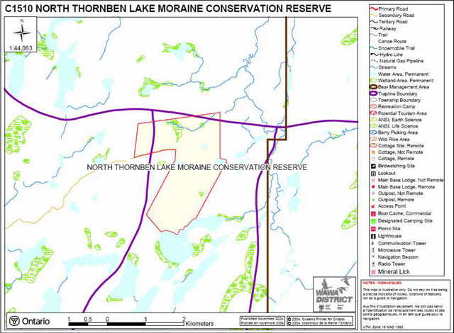
The North Thornben Lake Moraine Conservation Reserve is situated approximately 55 km northeast of the town of Manitouwadge, and north of Highway 625. The boundary is marked by features such as Thornben Lake as well as vectored boundaries (Appendix 8.1). Access to the CR is available by aircraft, some secondary and tertiary roads, or by foot. Location and administrative information is presented in Table 1.
Table 1: Location and Administrative Details for North Thornben Lake Moraine Conservation Reserve
| Territorial District | Thunder Bay |
|---|---|
| OMNR Region/District | Northeast/Wawa |
| Township | Unorganized |
| Ecoregion/Ecodistrict (Hills, 1959; Crins, 2000) | 3E (Lake Abitibi)/3E-2 (Hornepayne) |
| Regulation Date | May 21, 2003 |
| Total Area | 454 hectares |
| Ownership | Crown |
| UTM Coordinates | 5489000N 613000E |
| Map Number(s) | 42F/11 (Osawin River) |
| Nearest Town/Community | Hillsport/Manitouwadge/Hornepayne |
| OBM Numbers | 2016610054800 - 2016610054900 |
| Wildlife Management Unit | 21B |
| Forest Management Unit | Big Pic Forest |
The North Thornben Lake Moraine Conservation Reserve contains a variety of interesting landform features including wetlands, headwaters, lakes, and glacial deposits. These features provide an interesting landscape for recreational opportunities and a suitable habitat for a variety of flora and fauna.
The conservation reserve is located in Ecodistrict 3E-2 which is characterized by smooth to gently rolling plain with low ridges of productive stands of poplar, birch, conifer, and flats of unproductive black spruce and jack pine (Hills, 1959; Poser, 1992; Crins, 2000). North Thornben Lake Moraine Conservation Reserve is dominated by glacial sediment deposits. The surficial geology is characterized by underlying Bedrock-Drift Complex (Unit 2), Till Deposits (Unit 3), Ice-Contact Stratified Drift Deposits (Units 4a and 4), Glaciolacustrine Deposits (Unit 6), and Organic Deposits (Unit 9) (Kristjansson, 2004).
The forest climate type is mid-humid, mid boreal (Crins, 2000). Regional vegetation includes spruce, fir, poplar and birch on moderately sloping terrain (King, 2003). The conservation reserve is located in the tertiary watershed 4JD of the Albany River (OMNR 2002).
The conservation reserve is located in the Central Plateau section of the Boreal Forest Region (Rowe, 1972). The Forest Resource Inventory (FRI) data for this site primarily shows balsam fir mixedwood, poplar mixedwood, poplar dominant hardwood, and poplar predominant hardwood. Other forest communities present include black spruce conifer mixed, black spruce pure, black spruce dominant conifer, poplar hardwood mixed, black spruce predominant conifer, and white spruce pure. The age distribution of the site is relatively even-aged between 90 and 119 years old with some pockets of black spruce over 120 years old and some areas less than 20 years old (King, 2003).
4.2 History of the site
North Thornben Lake Moraine CR was identified for its life science values (landform vegetation combinations) through the Ontario’s Living Legacy (OLL) Land Use Strategy (1999).
The conservation reserve is within the Ojibways of the Pic River First Nation and the Long Lake Reserve #58 traditional land use area. Constance Lake First Nation and Ginoogaming First Nations have been known to use the area as well. The site is in the area covered by the Nishnwabe Aski Nation (NAN) territory and Treaty #9 area.
Disturbance in the North Thornben Lake Moraine Conservation Reserve is low (area less than 10% of the CR); there has been no aggregate or mineral extraction. There has been logging on the west side of the CR (King, 2003). There is no record of forest fire in the reserve (OMNR, 2004).
4.3 Inventories
Table 2 illustrates the inventories/surveys completed for North Thornben Lake Moraine CR, as well as any future requirements for earth and life sciences, cultural, recreational or other categories. The detailed Earth (Kristjansson, 2004) and Life Science Checksheets (King, 2003), and sections 4.1 and section 5.0 describe the key features of the CR.
Table 2: Inventory and Survey Information for North Thornben Lake Moraine Conservation Reserve
| Survey Level | Earth Science | Life Science | Cultural | Recreational |
|---|---|---|---|---|
| Reconnaissance | Kristjansson,F.J. 2004. North Thornben Lake Moraine Conservation Reserve (C1510) Approved Earth Science Checksheet | King, L., B. Burkhardt, and S. Longyear. 2003. North Thornben Lake Moraine Conservation Reserve (C1510) Life Science Checksheet – Step 4. | Big Pic and Black River Cultural Heritage Sites (1980) and Native Values Maps Manitouwadge Area (2001) | East, S., 2004,North Thornben Lake Moraine Conservation Reserve (C1510) Recreation Resource Inventory Report. |
| Detailed | None | None | None | None |
| Requirement | Recommend ground truthing | Comparison with current provincial landform layers | None | Recommend monitoring |
5.0 State of the resource
This section will identify the state of the resource within, bordering or crossing the boundary of the site. The state of the resource will include the natural heritage values present within the site and those values that are adjacent to but within the CR boundary or that may cross the conservation reserve’s boundary within the general use area where an artificial vectored boundary exists. Current land use activities including tenure and past and current development within the planning area will also be discussed.
5.0.1 Features represented in this Conservation Reserve
North Thornben Lake Moraine Conservation Reserve is comprised of forest lands, lake and creek systems, and wetland complexes. This site was originally identified for its life science values, specifically landform/vegetation combinations, through the OLL Land Use Strategy. Forest communities identified in the FRI data show that balsam fir mixedwood, poplar dominant hardwood, poplar predominant hardwood and poplar mixedwood make up a large portion of the conservation reserve (King, 2003). Poplar stands in the north and south portions of the conservation reserve are in a state of decline indicating they are old growth (King, 2003).
Landforms in the site are dominated by ice-contact stratified drift deposits, glaciolacustrine deposits and till deposits (Kristjansson, 2004). There are also areas of organic deposits and bedrock drift complex dispersed throughout the site (Kristjansson, 2004).
Wetlands in this conservation reserve include a mixture of open water marsh, open bog poor fen, intermediate conifer swamp and poor fen (King, 2003). Floating mats were also found on the western shore of Thornben Lake (King, 2003).
Thornben Lake contains warm water species; the thermal regime of Osawin River headwaters is currently unknown.
5.0.2 Quality of features represented
The quality of the representation and the current characteristics of the natural features found within the conservation reserve are as important as the overall representative features that are being protected. A number of factors are considered in the evaluation of the site, including; diversity, ecological factors, condition, special features and current land use activities.
Diversity
Diversity is a measure of the site’s life and earth science variability. It is based on the number and variety of natural landscape features and earth science values. Based on the size of the site, the number of forest units and land form features, the diversity of North Thornben Lake Moraine CR is considered to be high (King, 2003). There are 29 landform:vegetation combinations when considering the landform features, forest communities and developmental stage (King, 2003). The wetlands also contribute to the diversity of the conservation reserve. Evenness is the number of communities that control the vegetative nature of the site. The North Thornben Lake Moraine Conservation Reserve is moderately skewed (30-59%) towards poplar mixedwood, balsam fir mixedwood and poplar dominant hardwood forest communities (King, 2003)
Ecological factors
Ecological factors are significant to the quality of representation within the reserve and include size, shape, sensitivity to potential disturbances, and current linkages to the larger landscape.
While some of the conservation reserve boundary follows natural features a large portion of the boundary is vectored. Vectored boundaries can weaken the site’s ability to protect against adjacent land uses such as the harvesting that has occurred adjacent to the sites boundary. The current boundary goes beyond the moraine landform configuration and provides better protection from core values such as the moraine and the balsam fir mixedwood, and black spruce predominant conifer forest communities (King, 2003). Future activities around the conservation reserve should be monitored carefully through sustainable management planning such as the Big Pic Forest Management Plan.
Condition
Disturbance within the North Thornben Lake Moraine Conservation Reserve is ranked as low. Harvesting has occurred adjacent to the conservation reserve on the west side and within the conservation reserve (King, 2003). Regeneration of white spruce, black spruce appears to be doing well (King, 2003). Natural disturbance includes damage from birch skeletonizer (Bucculatrix canadensisella) scattered throughout the site (Burkhardt, 2002). There are no apparent trails or cabins within the boundary of the conservation reserve. There is a portion of a tertiary road on the western side of the conservation reserve along the boundary running east/west (see 8.1.1). Limited man-made disturbances and remoteness of the conservation reserve allows for good protection of features and a high quality of representation.
Special features
There are no known significant wildlife features or habitat for vulnerable, threatened, or endangered (VTE) species in the conservation reserve. There are no significant or special life science features associated with this conservation reserve (King, 2003).
Current land use activities
Current land use activities are limited to trapping, fishing and hunting (personal communication Sheldon Plummer, 2004).
5.1 Social/Economic interest in the area
Linkage to local communities
This conservation reserve contributes to the local communities by providing an ecosystem that supports the production of fauna. Local trappers, hunters and fishermen who harvest within the site indirectly benefit the local community economy.
Heritage estate contributions
North Thornben Lake Moraine CR contributes to the province’s parks and protected areas by preserving a number of natural heritage values mentioned in the previous section (5.0). The lack of industrial disturbance and current land use in the CR will help to ensure that fragile vegetation communities, significant geological features and waters are protected into the future. Furthermore, the site’s distinctiveness as a record of glacial recession may distinguish this site as an important scientific benchmark in the years to come. Future managers will have to balance the need to maintain the quality of the current representation and the needs of present and future users.
Aboriginal groups
The conservation reserve is within the Ojibways of the Pic River First Nation and the Long Lake Reserve #58 traditional land use area. Constance Lake First Nation and Ginoogaming First Nation have been known to use the area as well. There are no known values located within the conservation reserve boundaries.
Mining Industry and Ministry of Northern Development and Mines
This conservation reserve has no mining tenure within it. According to the 1998 MNR Protected Areas Summary Report (B3), mineral resource assessment in 100% of the site was unknown.
5.2 Natural Heritage Stewardship (vegetative/plant community management and earth science value protection)
The life science targets achieved by the creation of this site are currently unknown (King, 2003). This is due to a discrepancy in the forest communities; one analysis states the CR is dominated by mixedwood (deciduous) with some dense coniferous and deciduous stands, while another analysis suggests the split between dominantly deciduous and dominantly coniferous is closer to 50:50 (King, 2003). The earth science features found in the CR are considered provincially significant (Kristjansson, 2004). The ice-contact stratified drift and glaciolacustrine landforms are part of the White Otter Moraine. This moraine requires protection to complete the representation of the Timiskaming Interstadial Environmental Theme (Kristjansson, 2004).
There is no present monitoring or research program being conducted in conjunction with this conservation reserve.
Current fire management is concurrent with that practiced on adjacent crown land. Management strategies are described in section 6.2 State of the Resource Management Strategies. Insect damage to white birch trees by the birch skeletonizer (Buccalatrix canadensilla) has been recognized in the conservation reserve (King, 2003). No management plan has currently been initiated to control damage caused by this pest.
Continued monitoring or further studies on lakes or rivers in the conservation reserve have not been identified.
5.3 Fisheries and wildlife
North Thornben Lake Moraine Conservation Reserve is home to large wildlife species such as black bear and moose. The conservation reserve is also inhabited by a number of small game species such as snowshoe hare, marten, weasel, mink, muskrat, lynx, fox, beaver, and otter. Inventories have not been conducted to verify the other wildlife species that may utilize this site.
No lake survey data was found for any lakes in the conservation reserve. Lakes in the surrounding area are known to contain yellow perch, northern pike and white sucker (personal communication Dave Arola, 2004). No information could be found for Owasin River.
There have been no recent inventories performed for vulnerable, threatened and endangered (VTE) species at risk. There are no known VTE species or habitats within the conservation reserve. Additional studies and subsequent development of protection/restoration plans would be conducted if warranted.
5.4 Cultural Heritage Stewardship
There are no known values located within the boundaries of the conservation reserve at this time.
5.5 Land use/current or past development
As described in previous sections, past land use has been low, and there are no known developments on site. There is a tertiary road on the west border of the CR; a remnant of previous logging activity. The conservation reserve rests on Crown Land and is unencumbered by any land use permit, leases or mining claims. No further management actions, such as acquisitions or restrictions on existing use, are required.
5.6 Commercial use
North Thornben Lake Moraine CR is within one active bear management area (BMA) (TR-21B-028). It is unknown to what extent the area within the conservation reserve is used to hunt bear. This site is also within 2 active traplines; WA-151 and WA-162. Species harvested in the trapline areas include beaver, mink, marten, otter, lynx, weasel and fox. One baitfish area also comes within the boundaries of the conservation reserve (TR-04) however it is inactive.
There is no other known commercial use associated with this area.
5.7 Tourism/recreation use/opportunities
Tourism and/or recreational opportunities in this conservation reserve are currently very low due to its inaccessibility. Trapping, hunting, and fishing are activities that currently exist within the conservation reserve. There is potential for tourism/recreation use to develop in the future. Hiking trails could potentially be developed in the future and camp sites could be cleared to allow for back country camping experiences (these proposals would have to pass a Test of Compatibility).
There are no current proposals submitted for recreational development.
5.8 Client services
No infrastructure or interpretive facilities are proposed for the site. Informal wildlife viewing and nature appreciation can continue without further development.
6.0 Management guidelines
6.1 Management planning strategies
The land use intent outlined in Ontario’s Living Legacy Land Use Strategy and the Crown Land Use Policy Atlas provides context and direction to land use, resource management, and operational planning activities on Crown Land. Commitments identified in the above strategy and current legislation (PL Procedure 3.03.05) will form the basis for land use within North Thornben Lake Moraine Conservation Reserve. For up-to-date information on permitted uses refer to the Crown Land Use Policy Atlas at /page/crown-land-use-policy-atlas See Appendix 8.3 for a summary of permitted uses in North Thornben Lake Moraine Conservation Reserve.
Existing permitted uses within the conservation reserve may continue, unless they are shown to have a significant negative impact on the values within the site.
Proposed uses and development within the conservation reserve will be reviewed on a case-by-case basis. A Test of Compatibility (Appendix 8.2) must be passed before they are deemed acceptable. The emphasis will be on ensuring that the natural values of the conservation reserve are not negatively affected by current or future land use activities. Therefore, any application for new specific uses will be carefully studied and reviewed. The Ministry of Natural Resources, partner organizations and/or proponents may undertake such studies. Applicable environmental assessment requirements will also be met according to A Class Environmental Assessment for MNR Resource Stewardship and Facility Development Projects (upon its approval, A Class Environmental Assessment for Provincial Parks and Conservation Reserves will apply). Authorization for potential compatible uses will be in the form of a Land Use Permit or a Licence of Occupation.
6.2 State of the resource management strategies
Natural Heritage Stewardship – Vegetative/plant community management and earth science value protection
This conservation reserve will be managed by allowing vegetative communities to develop while existing traditional and recreational uses continue. Monitoring of sensitive wetland complexes may be necessary depending on the degree of recreational use.
The MNR recognizes fire as an essential process fundamental to the ecological integrity of conservation reserves. In accordance with existing Conservation Reserve Policy and the Forest Fire Management Strategy for Ontario, forest fire protection will be carried out as on surrounding lands.
Whenever feasible, the MNR fire program will endeavour to use "light on the land" techniques, which do not unduly disturb the landscape, in this conservation reserve. Examples of light on the land techniques may include limiting the use of heavy equipment or limiting the number of trees felled during fire response efforts.
Opportunities for prescribed burning to achieve ecological or resource management objectives may be considered. These management objectives will be developed with public consultation prior to any prescribed burning, and reflected in the document that provides management direction for this conservation reserve. Plans for any prescribed burning will be developed in accordance with the MNR Prescribed Burn Planning Manual (OMNR, 1997), and the Environmental Assessment Act (R.S.O. 1990, Chapter E.18).
Personal use permits for wood harvesting are not permitted. Salvage of standing, fallen, or sunken dead trees will not be permitted, except when authorized in conjunction with approved maintenance activities.
The collection/removal of vegetation and parts thereof (including Taxus Canadensis) will not be permitted. However, subject to a Test of Compatibility (Appendix 8.2), the Area Supervisor may authorize the collection of plants and/or parts for the purposes of research or scientific study within the reserve if required.
Forest renewal by artificial means will not be appropriate for a natural area. Similarly control of native pests will not be permitted. Programs may be developed to control invasive non-native forest insects and diseases in the conservation reserve where these threaten significant values in or adjacent to the site. Where insects or disease threaten significant values, in or adjacent to the site, control will be directed as narrowly as possible to the specific insect or disease. Biological control will be used whenever possible. If this circumstance should arise the control method would undergo a Test of Compatibility (Appendix 8.2).
All earth and life science features will be protected by defining compatible uses, enforcement direction through applicable legislation, and monitoring and mitigating issues. Industrial activities such as; timber harvesting, prospecting, mining, and new hydro generation will not be permitted within the boundaries of the conservation reserve. Energy transmission, communication and transportation corridors or resource roads or construction of facilities are discouraged, through existing planning process. Exceptions based on a Test of Compatibility (Appendix 8.2) may be made for minor structures.
Ontario Ministry of Natural Resources will provide leadership and direction for maintaining the integrity of this site as a natural heritage estate. Research, protection, education and understanding and interpretation of the natural heritage features of the site will be encouraged and fostered through local and regional natural heritage programs and initiatives.
Fisheries and wildlife
Fish and wildlife resources will continue to be managed in accordance with policies and regulations prevailing in the area and under the direction of the Manitouwadge Area Supervisor. Provincial legislation and policy will dictate management and enforcement objectives for this area.
Existing hunting and sport fishing by outfitters' clients and the general public will be permitted. No new commercial outfitting, outpost, hunting camps or new trap cabins will be permitted within the boundaries of the conservation reserve. The introduction of exotic and/or invasive species will not be permitted.
Cultural heritage
Should the MNR consider new structural development, significant clearing of vegetation or altering of land within this conservation reserve, the MNR will adhere to the cultural heritage resource screening process as is identified in its Memorandum of Understanding (MOU) with the Ministry of Culture (MCL). While the purpose of this MOU is to provide a process to identify and protect cultural heritage resources when the MNR is reviewing work permits or disposing of Crown rights under the authority of the Public Lands Act, the considerations and criteria would also enable the MNR to identify high potential cultural heritage areas for other purposes within conservation reserves. If the screening process indicates that the site of a proposed activity is within an area of high cultural heritage potential, the MNR will consult with the MCL to determine the appropriate cultural heritage assessment requirements and will ensure a preliminary archaeological assessment if appropriate.
All aboriginal and treaty rights will continue to be respected and are not affected by the establishment of this conservation reserve.
Any future proposals or decisions that have potential impact(s) on the individual or aboriginal or community values will involve additional consultation with the affected aboriginal groups.
Social/economic
Under the Ontario Living Legacy Land Use Strategy, mining and related access will be allowed in a forest reserve (FR). For those activities that could negatively influence the natural heritage values within the FR and/or the CR, the district will work with the proponent to identify and mitigate potential mining or natural heritage concerns.
Mining will not occur in any portion of the regulated conservation reserve boundary.
Land use/past and existing development
Conservation reserve regulations do not permit mining, commercial forest harvesting, hydroelectric power development, the extraction of aggregate and peat or other industrial uses (Public Lands Act, Ontario Regulation 805/94).
The sale of Crown Lands within the conservation reserve is not permitted.
New recreation camps will not be permitted however; existing recreation camps will be permitted to continue. Existing camps may be eligible for "enhanced" tenure, but are not eligible for purchase of land. There are two forms of enhanced tenure that may be considered:
- Upgrade in the nature or type of tenure (e.g. from Land Use Permit to a lease); and/or
- An extension in the term of the tenure (e.g. from 1 year to 10 years)
Applications for enhanced tenure will be approved if determined acceptable using a screening criteria. A change in tenure does not convey a commitment to provide for, or agree to, a change in the type or the standard of existing access to the recreation camp.
Unauthorized occupations of lands within the conservation reserve will be handled in accordance with approved policy, and any required structural removal will be at the owner’s expense.
New roads for resource extraction and/or private use will not be permitted, nor will additions to existing roads or upgrading of existing private roads be permitted.
New trails are not encouraged, however they may be considered when compatible with other recreational uses and the maintenance of environmental integrity. Any new trail development must go through a Test of Compatibility (Appendix 8.3) to ensure the quality of the life and earth science representation and any additional values (e.g. aesthetics, landscape views, sensitive areas) are maintained.
Use of existing authorized ATV and snowmobile trails will be permitted to continue as long as they do not impair the natural features and values for which the area is identified and there are no significant environmental impacts. Consideration for new ATV and snowmobile trails will occur on a case-by-case basis. Public consultation will be an important part of the process. Non-trail snowmobile and ATV use will be permitted only for the direct retrieval of game and/or bait.
The use of existing unauthorized trails will be monitored to ensure that conservation reserve values are not being adversely impacted. Depending on the results of the monitoring, some of the unauthorized trails may need to be redirected from sensitive areas or eliminated completely.
The district may sometime in the future consider developing a trails strategy to ensure the values within the conservation reserve are fully protected while maintaining current permitted uses to occur.
Facility infrastructure and development for recreation may be considered in the future if there is a demonstrated need for such facilities. A more detailed management plan would be required prior to construction.
Commercial use
Existing non-industrial commercial uses such as trapping and baitfish harvesting will be permitted to continue. Renewals and transfers will also be permitted. These activities will continue to be monitored in order to ensure they do not deplete natural resources and that they impose a minimal impact on the features identified for protection.
New non-industrial commercial activities (e.g. traplines) which overlap with the conservation reserve may be considered subject to a Test of Compatibility, consistent with provincial direction. Any new trails associated with the new non-industrial commercial activities must also be considered subject to a Test of Compatibility.
Existing commercial bear hunting operations are permitted to continue but the introduction of new operations will not be allowed. Lapsed BMA's will not be reactivated, and transfer requests will be dealt with on a case-by-case basis.
Commercial wild rice harvesting will not be permitted. Other commercial food collection will also be prohibited; particularly mechanical blueberry harvesting methods that can damage plants and deplete the crop available for recreational pickers.
Tourism/recreation
Tourism proposals will be assessed on a case-by-case basis and approved if compatible with natural values and other uses that may exist at the time.
Blueberry picking and other food gathering will continue to be permitted on a recreational basis.
Client services
The focus will remain on low key information and self-interpretation of conservation reserve features. Messages should focus on the area’s natural heritage features, recreation opportunities, nature appreciation and education.
At the present time there are no plans for structural development within this conservation reserve.
6.3 Specific feature/area/zone management strategies
There are no known specific features in the conservation reserve that require special attention or management at this time. Wetlands, as a feature sensitive to disturbance, should be analysed for provincial significance and managed accordingly.
The North Thornben Lake Moraine CR has not been delineated into zones for management of a specific resource. Zoning of the CR for management of special features will require an amendment to this SCI. Research in the CR will be encouraged, and some research activities could conceivably require special conditions such as elimination of noise or restrictions on harvesting of wildlife.
6.4 Monitoring, assessment and research
Further analysis and classification of the vegetative communities and landform layers to determine the site’s significance and contribution to the parks and protected areas program should be considered in any future assessment of the conservation reserve.
The state of the forest should be monitored and consideration given to the changing species as a result of natural succession and managed accordingly (King, 2003). Distribution of surficial geological units within the CR should be confirmed through ground truthing (Kristjansson, 2004). The origin of the White Otter Moraine as a sediment accumulation marking a re-entrant environment should be evaluated (Kristjansson, 2004). The current state of the CRs resources within and adjacent to the boundaries should be monitored to evaluate natural and human disturbances as well as any management prescriptions. Further review is recommended for the inventory and monitoring of life and earth science, and recreational features within the conservation reserve.
Consideration will be given to inventory and documentation of natural and cultural values, and the assessment of use/activity impacts. All research will be carried out in a non-destructive manner. Research proposals must follow Procedural Guideline C – Research Activities in Conservation Reserves (PL 3.03.05).
Research, education and interpretation will be encouraged to provide a better understanding of the management and protection of the natural heritage values and will be fostered through local and regional natural heritage programs, initiatives and partnerships.
6.5 Implementation and plan review strategies
Management of the CR will be done largely using a "hands-off" approach. For the short term, the forest community will develop and low impact activities described in the plan will continue. Emphasis will be placed on awareness information highlighting conservation reserve values and appropriate uses.
Priorities will include:
- Maintaining the quality of life science and earth science representation features, such as the ice-contact drift deposit formations, while providing for the needs of recreation and other users
- Monitoring impacts of existing recreation use on the conservation reserve to ensure adherence to the management guideline and mitigating any negative effects
- Working with adjacent SFL holders and stakeholders to protect important values (e.g. high diversity landform:vegetation combinations) that may be disturbed as a result of the vectored boundaries
North Thornben Lake Moraine Conservation Reserve SCI will be reviewed on an ongoing basis as there is no formal review or expiry date for the document. This SCI will be amended through a standard process of minor and major amendments. Minor amendments will be processed in a relatively informal manner and will require the approval of the Manitouwadge Area Supervisor. These amendments will deal with uses and activities that do not affect any of the policies in this SCI (e.g. new uses and/or activities that are consistent with existing permitted uses).
Uses and/or activities that were not anticipated in the approved SCI and which may have an impact on the values of the conservation reserve will require a major amendment. In assessing major changes, the need for a more detailed Resource Management Plan will first be considered. This will include an opportunity for public comment and input and will require the approval of the Wawa District Manager and the Regional Director.
This SCI or future RMP, if required, plus the Crown Land Use Atlas and associated website (/page/crown-land-use-policy-atlas) will be amended to reflect any changes in management direction.
6.6 Marketing strategies
The site will be more generally promoted as part of the Parks and Protected Areas initiative, and at the current time information on the North Thornben Lake Moraine CR is available worldwide on the Crown Land Use Policy Atlas website at (/page/crown-land-use-policy-atlas).
Marketing activities will be kept to a minimum and there are no plans to actively promote the area for research or commercial purposes such as tourism at this time.
7.0 References
Burkhardt, B. 2002. C1510 Life Science Aerial Field Survey Notes, OMNR.
Crins, W.J. 2000. Ecoregions of Ontario: Modifications to Angus Hill’s Site Regions and Site Districts – Revisions and Rationale.
East, S. 2004. North Thornben Lake Moraine Conservation Reserve (C1510) Recreation Resource Inventory Report.
Hills, G. 1959. A ready reference to the description of the land of Ontario and its productivity.
King, L., B. Burkhardt, and S. Longyear. 2003. North Thornben Lake Moraine Conservation Reserve (C1510) Life Science Checksheet – Step 4.
Kristjansson, F.J. 2004. North Thornben Lake Moraine Conservation Reserve (C1510) Approved Earth Science Checksheet.
Ministry of Culture and Recreation, Historical Planning and Research Branch. 1980. Big Pic and Black River Cultural Heritage Sites, Archaeological Survey of Canada.
Ontario Ministry of Natural Resources (OMNR). 2002. MNR districts and major basins of Ontario.
Ontario Ministry of Natural Resources (OMNR). 2004. Forest Fire Data Summary for the Wawa District.
Ontario Ministry of Natural Resources (OMNR). 1997. MNR Prescribed Burn Planning Manual
Poser, S. 1992. Report of the status of provincial parks in the site region and districts of Ontario. Ontario Ministry of Natural Resources Report.
Rowe, J.S. 1972. Forest Regions of Canada.
8.0 Appendices
8.1 Maps
8.1.1 Recreation Inventory map
Enlarge Recreation Inventory map of North Thornben Lake Moraine Conservation Reserve
8.1.2 Site location map
Enlarge Site location map of North Thornben Lake Moraine Conservation Reserve
8.1.2 Boundary map
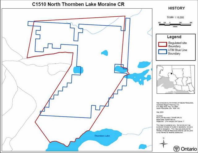
Enlarge Boundary map of North Thornben Lake Moraine Conservation Reserve
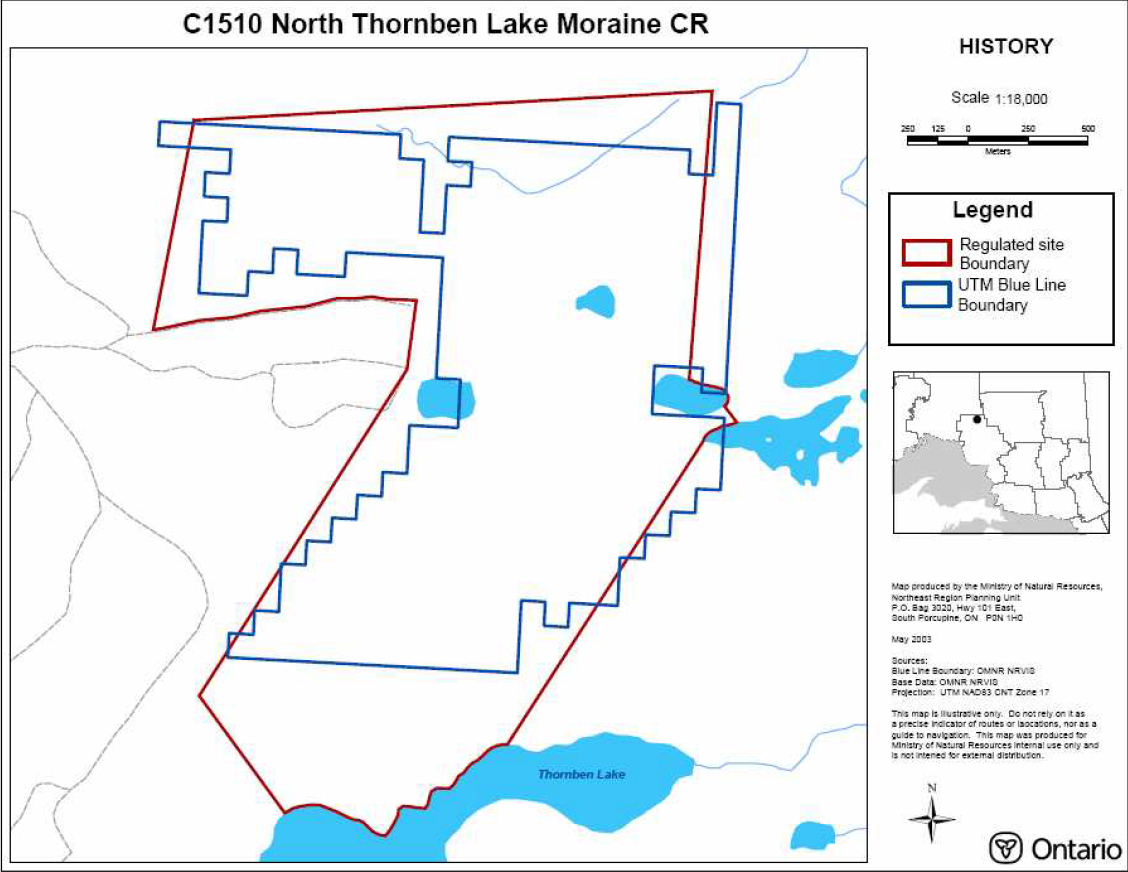
8.2 Procedural guideline B – Land Uses – Test of Compatibility (PL procedure 3.03.05)
The Conservation Reserve policy provides broad direction with regard to the permitted uses. The policy provides only an indication of the variety of uses that will be considered acceptable in conservation reserves. The only caution is that "any new uses, and commercial activities associated with them, will be considered on a case by case basis, and, they must pass a test of compatibility to be acceptable."
What does a 'test of compatibility' mean?
An examination of this must start from the premise of why an area is set aside - specifically, its representative natural heritage values. Criteria are then identified to guide compatibility considerations. These criteria apply to the long-term acceptability of both existing uses and new uses.
-
Conformity to SCI/RMP: SCI describe values for which an area has been set aside and the range of appropriate uses that will be permitted in the area. SCI may also speak to the acceptability of other 'new' uses currently not occurring in the area.
The first 'test' is: "do proposed new land uses and/or commercial activities conform to the direction of the SCI/RMP for the conservation reserve? Would the new use(s) depart from the spirit of appropriate indicator land uses in the SCI/RMP?"
- Impact Assessment: If the proposed use(s) pass test 1 it is important to determine their impact on the area before they are approved. This should include the following:
- Impact on natural heritage values: "will the new use(s) impact any natural values in the area? If so how and to what degree? Is it tolerable?"
- Impact on research activities: "will the new use(s) affect research activities in the area?"
- Impact on current uses: "will the new use(s) have any negative impact on the array of current uses?"
- Impact on area administration: "will the new use(s) increase administrative costs and/or complexity?" (For example, the cost of area monitoring, security and enforcement).
- Impact on accommodating the use outside the conservation reserve: "Could the use(s) be accommodated as well or better outside the conservation reserve?"
- Impact on socio-economics of the area: "will the new use(s) affect the community(ies) surrounding the area in a positive or negative way?" (For example, will the new use make an area less remote thereby affecting a local tourism industry that is dependent on the area’s remoteness for its appeal?"
- Impact on area accessibility: "does the new use(s) give someone exclusive rights to the area or a portion of the area to the exclusion of other existing uses?"
8.3 Summary of permitted land and resource uses
| Use | Permitted New | Permitted Existing |
|---|---|---|
| Commercial timber harvest, commercial hydro development | No | No |
| Mineral exploration and mining | No | No |
| Bait fishing, commercial fur harvesting | Maybe | Yes |
| Sport hunting | Yes | Yes |
| Sport fishing | Yes | Yes |
| Seasonal recreation camps ("hunt camps") | No | Yes |
| Commercial bear hunting | No | Yes |
| Tourism Facilities (for resource based tourism) and recreational trails | Maybe | Yes |
| Land Disposition | No | Yes |
| Roads | No | Yes |
| Energy Transmission and Communications Cooridors | No | Yes |
| Commercial Food | No | Yes |
| Harvesting | No | No |
| ATV and Snowmobile use on trails | Maybe | Yes |