Nottawasaga Lookout Provincial Park Management Statement
This document provides policy direction for the protection, development and management of Nottawasaga Lookout Provincial Park and its resources.
Interim Management Statement
2007
Approval statement
I am pleased to approve this Interim Management Statement for Nottawasaga Lookout Provincial Nature Reserve. Nottawasaga Lookout Provincial Nature Reserve was regulated under the Provincial Parks Act in October of 1994 (O. Reg. 768/94) and is managed as a nature reserve class park.
This Interim Management Statement provides direction for the protection and management of Nottawasaga Lookout Provincial Nature Reserve.
Signed by:
Brian Pfrimmer
Zone Manager
Central Zone, Ontario Parks
Date:
August 24, 2007
1.0 Introduction
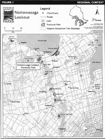
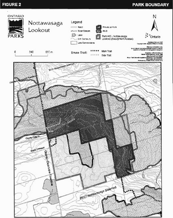
Nottawasaga Lookout Provincial Nature Reserve is situated on the Niagara Escarpment, 10 km south of Collingwood (Figure 1). It is located in Ecodistrict 6E-4, and contains 130 ha of land regulated under the Provincial Parks Act (O. Reg. 768/94) (Figure 2). The park features a number of outstanding characteristics representative of the escarpment landscape, and has been identified as an earth science Area of Natural and Scientific Interest (ANSI), mainly because of the excellent examples of crevice caves, talus slopes and associated forests. Nottawasaga Lookout Provincial Nature Reserve is located within the area designated by the Niagara Escarpment Plan (NEP, 2005).
Management of this park has been guided by an Interim Management Statement (IMS), which was approved in 1995. This updated IMS will provide direction for the custodial management of park resources. Any significant decisions regarding resource stewardship, development, operations, and permitted uses will require Ontario Parks to initiate additional planning processes, including public consultation.
Nottawasaga Lookout Provincial Nature Reserve is managed under the Wasaga Beach cluster of parks.
2.0 Classification
Through park classification, Ontario’s provincial parks are organized into broad categories, each of which has particular purposes and characteristics.
Nottawasaga Lookout is a nature reserve class park. The purpose of nature reserve parks is to provide representation of and protection to Ontario’s geological, ecological and species diversity. Where compatible with park values, low intensity day-use activities are encouraged.
The park is also classified by the NEP as a Nature Reserve within the Niagara Escarpment Parks and Open Space System (NEPOSS).
3.0 Objectives
Management of Nottawasaga Lookout Provincial Nature Reserve will be consistent with the four objectives for provincial parks, as described in the Provincial Parks and Conservation Reserves Act, 2006 (effective September 4, 2007):
- To permanently protect representative ecosystems, biodiversity and provincially significant elements of Ontario’s natural and cultural heritage and to manage these areas to ensure that ecological integrity is maintained.
- To provide opportunities for ecologically sustainable outdoor recreation opportunities and encourage associated economic benefits.
- To provide opportunities for residents of Ontario and visitors to increase their knowledge and appreciation of Ontario’s natural and cultural heritage.
- To facilitate scientific research and to provide points of reference to support monitoring of ecological change on the broader landscape.
Figure 1: Regional Context
Enlarge Figure 1: Regional Context
Figure 2: Park Boundary
Enlarge Figure 2: Park Boundary
4.0 Management context
Park management will follow direction from the:
- Ontario Provincial Parks Planning and Management Policies and updates;
- Provincial Parks and Conservation Reserves Act, 2006 (PPCRA) and regulations (effective September 4, 2007).
Ontario Parks will also act in accordance with the Niagara Escarpment Plan (NEC, 2005) and the Niagara Escarpment Planning and Development Act (NEPDA, Chapter N.2, R.S.O. 1990) when making planning decisions affecting the park. Part 3 of that plan includes objectives and policies for a Niagara Escarpment Parks and Open Space System (NEPOSS) as a framework for the establishment and coordination of a system of publicly owned lands on the escarpment as well as the Bruce Trail (NEC, 2005). Lands are managed by various public bodies including Ontario Parks, the Ontario Ministry of Natural Resources (MNR), Conservation Authorities, Parks Canada Agency and others. NEPOSS protects the significant natural and cultural features along the escarpment, and provides opportunities for recreation and public access. The PPCRA requires that a Park Management Plan be developed for all Provincial Parks. The NEP also requires that management plans be developed for all parks which fall within the NEPOSS.
The NEPOSS sets out a series of objectives for parks and public lands that fall within its jurisdiction. Management of the Nottawasaga Lookout Provincial Nature Reserve will contribute to several of these, including:
- To protect unique ecological and historical areas;
- To complete a public system of major parks and open space through additional land acquisition and park and open space planning;
- To maintain and enhance the natural environment of the Niagara Escarpment;
- To provide a common understanding and appreciation of the Niagara Escarpment; and
- To show leadership in supporting and promoting the principles of the Niagara Escarpment’s World Biosphere Reserve designation through sustainable park planning, ecological management, community involvement, environmental monitoring, research and education.
In 1990, the United Nations Educational, Scientific and Cultural Organization (UNESCO) designated the Niagara Escarpment as a World Biosphere Reserve in recognition of its natural heritage significance, and to recognize and endorse the Niagara Escarpment Plan. The Niagara Escarpment Plan was Canada’s first large-scale environmental land use plan, which uses policies to ensure the escarpment remains a sustainable natural environment for future generations.
When addressing custodial management to protect park features and values and ensure public health and safety, Ontario Parks will ensure that policy and environmental assessment requirements are implemented.
The Park Superintendent will implement the policies, procedures and legislation that are derived from the above direction and written into the Interim Management Statement for Nottawasaga Provincial Nature Reserve.
4.1 Environmental assessment
As part of the MNR, Ontario Parks is a public sector agency subject to the provincial Environmental Assessment Act and the Canadian Environmental Assessment Act. Management of this park will be carried out in accordance with legislation, policies and the MNR Class Environmental Assessment for Provincial Parks and Conservation Reserves.
5.0 Aboriginal rights
Nothing in this interim management statement shall be construed so as to abrogate or derogate from the protection provided for the existing Aboriginal or treaty rights of the Aboriginal people of Canada as recognized and affirmed in Section 35 of the Constitution Act, 1982.
The park is not subject to any aboriginal land claims.
6.0 Boundary
The boundary of Nottawasaga Lookout Provincial Nature Reserve is described in Ontario Regulation 768/94. Nottawasaga Lookout Provincial Nature Reserve is located in the northwestern portion of Clearview Township in Simcoe County. The park occupies part of Lot 29, Concession 12, Part of Lots 27 & 28, Concession 12; and part of Lot 27, Concession 11 of the former Nottawasaga Township (Figure 2).
7.0 Park features and values
Nottawasaga Lookout Provincial Nature Reserve protects provincially significant landform features and ecological features associated with the Niagara Escarpment.
The park protects a representative portion of the Niagara Escarpment, which is one of the most significant geological formations in Ontario. The formation of the escarpment dates back approximately 450 million years; today it supports a variety of ecological communities, including rare vegetation species. The escarpment also functions as an ecological corridor and is one of the last remaining contiguous natural areas in Southern Ontario.
7.1 Life sciences
Nottawasaga Lookout Provincial Nature Reserve is located within Ecodistrict 6E-4, which encompasses a portion of the Niagara Escarpment. The park comprises a large portion of the provincially significant Nottawasaga Lookout Area of Natural and Scientific Interest (ANSI), and includes areas of escarpment plain forests, moist open cliffs, moist crevice caves at the base of the escarpment, dry-mesic mixed talus forests, ravine habitats and some small riparian and wetland habitats.
Twenty-five vegetation types have been identified in the nature reserve, including 5 rare vascular plant communities. Of these, nine deciduous forest vegetation types are present and occupy the thin escarpment rim soils and the upper slope and tablelands of the park. Sugar maple (Acer saccharum) is the dominant forest tree, with American Beech (Fagus grandifolia), Hop Hornbeam (Ostrya virginiana), White Ash (Fraxinus americana) and White Birch (Betula papyrifera) being co-dominant. Three mature Butternut trees (Juglans cinerea) were found in the park in 2002 (Korol, 2003). This species was designated as endangered by COSEWIC in 2003 due to its vulnerability to disease and specific habitat type needed for regeneration to occur (Thompson, 2006). Two mixed forest community types have also been identified in the area of the escarpment rim, adjacent to the crevices in the western portion of the park. These include mixed variations of White Birch, Eastern White Cedar (Thuja occidentalis), and various other deciduous trees (Korol, 2003).
The cliff face located within the park was included in The Niagara Escarpment Ancient Tree Atlas Project (Kelly & Larson, 2003) and was found to have three notable cedar trees aged at 101, 198 and 305 years old existing along the escarpment edge. The reserve also includes some small riparian and wetland areas, including an artificial pond. Despite their small size, these wetland communities contribute greatly to the vascular plant species richness of the park (Korol, 2003).
Twenty-five varieties of fern have been identified within the park, including the provincially rare American Hart’s Tongue fern (Asplenium scolopendrium var. americanum). This particular species is designated as Special Concern by both the MNR and COSEWIC (2000).
The forests provide habitat for at least 60 species of birds, including five species of woodpecker and several species of passerines, many of which are nee-tropical migrants (Korol, 2003).
Fourteen species of mammals have been recorded in the reserve including Red Bat (Lasiurus borealis), porcupine (Erethizon dorsatum), raccoon (Procyon lotor), and white-tailed deer (Odocoifeus virginianus) (Korol, 2003).
Approximately 25 per cent of the vascular plants found in the reserve are non-native. Non-native plants, such as garlic mustard (Alliaria petiofata) are concentrated in disturbed areas such as along the Bruce Trail, snowmobile trail and at the Singhampton Caves. (Korol, 2003).
7.2 Earth sciences
The Niagara Escarpment is a prominent geological feature that was formed by erosional processes on flat lying bedrock units. It was greatly impacted by the Laurentide ice sheets of the last ice age. The cuesta form of the escarpment was created by the removal of relatively soft shales from beneath a more resistant dolomitic caprock.
This area exposes a relatively continuous bedrock section typical of the north-central portion of the escarpment. The bedrock underlying this area is clastic and carbonate sediments of the Palaeozoic age. The cliff face in this area varies from a maximum of 14 metres high to being completely buried by sediment. For most of its length in this area, the escarpment is a low bedrock ridge at the lip of a gentle slope of rubble and glacial sediment (Kor, 1991). The park includes a system of deep crevice caves and talus block slopes associated with the escarpment that are considered to be an excellent representation of the process of mass wasting (Jalava, 1995). These lands also contain the Nottawasaga Lookout provincially significant Earth Science ANSI.
Below these escarpment features, a relatively flat bedrock plain marks a secondary scarp formed by the Whirlpool-Manitoulin formation of bedrock below the main Amabel formation (Kor, 1991). This formation is also considered to be provincially significant.
7.3 Cultural features
There are no published reports describing the cultural heritage of Nottawasaga Lookout Provincial Nature Reserve. Future planning will use the provincial framework, The Topical Organization of Ontario History as well as updates and discussions with other agencies, First Nations, and interest groups to identify cultural heritage values and features within the park. This information may be used to develop management guidelines to conserve and protect representative archaeological and historical values and features, as well as provide direction for further research.
8.0 Stewardship policies
An adaptive management approach will be applied to resource management activities within Nottawasaga Lookout Provincial Nature Reserve. Adaptive management enables modification of management practices and policies based on the outcome of operational programs and monitoring.
8.1 Industrial/commercial uses
The following uses are not permitted in Nottawasaga Lookout Provincial Nature Reserve:
- commercial forestry;
- commercial tourism;
- commercial fishing or baitfish harvesting;
- prospecting, staking mining claims, developing mineral interests, working mines;
- extraction of sand, gravel, topsoil or peat;
- commercial hydroelectric power development;
- trapping;
- fuel wood cutting;
- timber salvage and sunken log retrieval; and/or
- commercial harvesting of non-timber forest products (e.g. wild rice, Canada yew, etc.).
Aboriginals exercising treaty rights are permitted to continue commercial fur harvesting in all parks, subject to applicable legislation and regulation.
8.2 Land management
8.2.1 Access and crossings
Nottawasaga Lookout Provincial Nature Reserve is accessed by the 26/27 Nottawasaga (Lobsinger) Sideroad, which is located along the reserve’s southern edge (Lot 27 - Con 13). The Osprey-Ciearview Townline is not opened and maintained to the park, however, there is roadside parking and trail access at the comer of the Townline and Eagle Crescent (Figure 2).
The Bruce Trail Main Trail and The Standing Rock and Caves and Singhampton Side Trails traverse the park, providing easy public access and a variety of wildlife and landscape viewing, exploring, and hiking opportunities during all seasons. Approximately 5.3 km of the Bruce Trail runs through the park, including 850 m of side trail, and will be managed in cooperation with the Bruce Trail Association. The trail is accessible via the 26/27 Nottawasaga (Lobsinger) Sideroad at the south end of the reserve or at the end of Eagle Crescent on the west side (Figure 2).
The Blue Mountain Snowdrifters Snomobile Club maintains a section of trail through the nature reserve. As a result of public consultation held prior to the establishment of the provincial nature reserve, the snowmobile trail will be permitted to remain in the park on an interim basis as an existing, non-conforming activity.
There are no utility corridors located within the boundary of the park. When no feasible alternatives exist, any future utility corridors (e.g., gas pipelines, transmission lines, communications towers, etc.) proposed to go through the park, will be reviewed on a case-by-case basis.
There are no roads in the park and new road development will not be permitted.
8.2.2 Parking
Nottawasaga Lookout does not host any parking or trail staging areas. There is limited room to park vehicles and access park trails located at the junction of the Townline and Eagle Crescent and the 26/27 Nottawasaga Sideroad. To date, roadside parking has been occurring with the widening of the gravel roads, allowing one to two cars at each site.
8.2.3 Land use
There are no land use permits and no known unauthorized occupations within Nottawasaga Lookout Provincial Nature Reserve. No new land use permits or licences of occupation will be granted.
No land disposition for the private use of individuals or corporations will be permitted.
8.2.4 Adjacent land management
Lands totalling 115 ha located adjacent to the park to the south (Part Lots 27 and 28, Concession 12) and to the northeast (Part Lot 28, Concession 11 and Part Lot 29, Concession 12) are Crown Land, managed by the MNR (Figure 2). Other surrounding lands are patent and are rural residential or agricultural in nature. Ontario Parks will support the acquisition of property for the purposes of addition to the park, if acquisition will enhance the values of the park. Acquisition or securement will be subject to funding and willingness of the owners to sell or lease their properties or enter into a conservation easement.
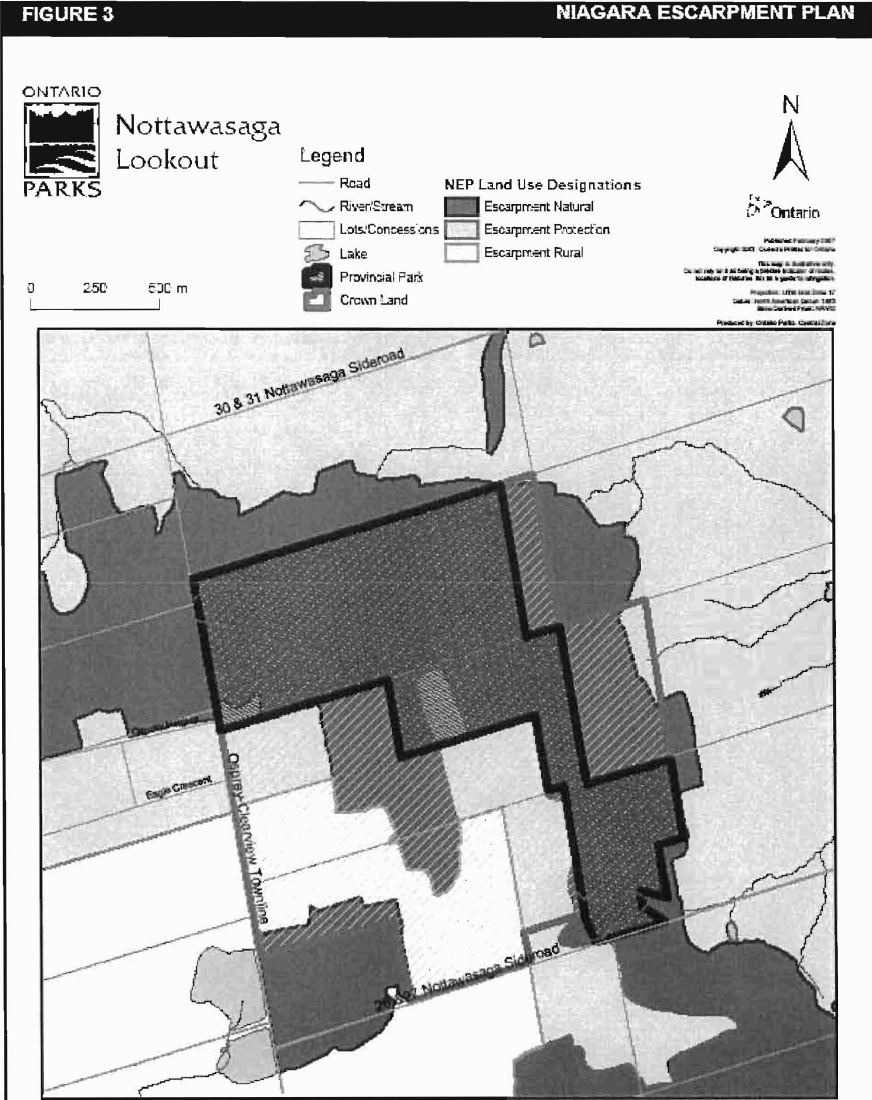
The Niagara Escarpment Plan, which is implemented by the Niagara Escarpment Commission, delineates seven land use designations, each outlining objectives and permitted uses. Nottawasaga Provincial Nature Reserve is surrounded by land which is classified under three of these designations: Escarpment Natural Area, Escarpment Protection Area and Escarpment Rural Area. The park itself is designated Escarpment Natural Area and Escarpment Protection Area (see Figure 3).
Escarpment Natural Areas contain features which are in a relatively natural state. Associated stream valleys, wetlands and forests which are relatively undisturbed are included within this designation. These contain important plant and animal habitats, geological features, cultural heritage features, and are the most significant natural and scenic areas on the escarpment. This designation receives the highest protection and allows only for compatible land uses (NEC, 2005).
Escarpment Protection Areas are important because of their visual prominence and their environmental significance. They are often more visually prominent than Escarpment Natural Areas. Included in this designation are escarpment features significantly modified by land use activities such as agriculture or residential development, land to buffer lands for prominent Escarpment Natural Areas, and natural areas of regional significance (NEC, 2005).
Escarpment Rural Areas are an essential component of the escarpment corridor, including portions of the escarpment and lands in its vicinity. They provide a buffer to the more ecologically sensitive areas of the escarpment and allow for the continuation of agriculture and related uses (NEC, 2005).
8.2.5 Land acquisition
Approximately 28.8 ha of publicly owned lands adjacent to the northeast portion of the park are recommended to be added to the Nature Reserve (Figure 2). These lands are part of the Nottawasaga Lookout Life Science ANSI, which identifies the area as containing provincially significant natural heritage features; and have been acquired by the Crown for the purposes of adding to the Nature Reserve.
- the east part of Lot 29, Concession 12
- the west quarter of Lot 28, Concession 11, Part 1 Plan 51R-25751
In the Township of Clearview (former Nottawasaga), Simcoe County.
8.3 Water management
Sustaining high quality water resources is fundamental to the protection of park and adjacent land features and values. The Ontario Ministry of the Environment enforces applicable legislation and regulations pertaining to water quality.
There are no major waterbodies or rivers located within the park. There are a few small wetlands (<1 ha in size) and some intermittent streams scattered throughout the park. Additionally, there is one small pond located near the snowmobile trail and a few small runoff streams that flow through the site.
The policies in Section 2.6 of The Niagara Escarpment Plan (NEC, 2005) ensure new development affecting streams, watercourses, lakes, wetlands, and groundwater systems will have minimum individual and cumulative effects on water quality and quantity, and on the escarpment environment.
8.4 Non-native and invasive species
Where possible, actions will be taken to eliminate or reduce the threat of invasive and non-native plant and animal species which may be affecting the ecological integrity of naturally occurring populations. Where non-native species are already established and threaten natural or cultural values, a program of control may be undertaken if feasible and practical. Non-native species are species not native to Ontario or are species native to Ontario but not to the park. Non-native species will not be deliberately introduced. Invasive species are species that are likely to spread and negatively affect native ecosystems.
Figure 3: Niagara Escarpment Plan

Enlarge Figure 3: Niagara Escarpment Plan
8.5 Forest fire management
Fire management in Ontario is based upon a division of the province by management objectives, land use, fire load, and forest ecology. Nottawasaga Lookout Provincial Nature Reserve is located within the Southern Ontario Fire Management Zone. In accordance with existing provincial park policy and the Forest Fire Management Strategy for Ontario, forest fire management will be carried out in Nottawasaga Lookout Provincial Nature Reserve as it is on surrounding lands. Natural and human caused fires will be suppressed. Any prescribed fire management may be permitted by prescription and in a controlled setting. In the Southern Ontario Zone, municipalities have the primary responsibility for fire protection and management activities, under the Fire Protection and Prevention Act (FPPA) and through municipal bylaws. The MNR may be called for assistance if required.
8.6 Vegetation
Insects and diseases may be managed where the aesthetic, cultural, and/or natural features and values of the vegetation at Nottawasaga Lookout are threatened. Control will follow guidelines established by the Ontario Ministry of the Environment and the MNR. Whenever possible, biological controls will be used instead of chemicals.
8.7 Wildlife
Nottawasaga Lookout Provincial Nature Reserve is located in Wildlife Management Unit (WMU) 818, however hunting and commercial fur harvesting are not permitted in the park. Removal and/or harassment of non-game animals is not permitted in provincial parks (Provincial Parks and Conservation Reserves Act, 2006, effective September 4, 2007).
Occasionally, animals may pose a threat to public safety, or to park facilities. Wildlife management may be undertaken on an as required basis in order to protect health and safety of park visitors and park staff, or to protect park facilities. The removal of nuisance animals will be undertaken by, or under the supervision of the Park Superintendent.
8.8 Fisheries
Some small tributaries of the Pretty River are located within the park boundaries.
Fisheries management will complement maintenance and enhancement of the native, self-sustaining fish populations. Non-native fish species will not be deliberately introduced into the waters of Nottawasaga Lookout Provincial Nature Reserve.
Sport fishing is permitted within Nottawasaga Lookout Provincial Nature Reserve. Any sport fishing activity is governed by the legislation and regulations in the Fish and Wildlife Conservation Act (1997), as well as the Federal Fisheries Act (1985). The Recreational Fishing Regulations Summary contains details regarding general regulations and exceptions to these regulations for the area of Nottawasaga Lookout Provincial Nature Reserve. The park is located within Fisheries Management Zone 16.
Nottawasaga Lookout Provincial Nature Reserve is located within a baitfish harvest area (MH-0011). The harvester requires Ontario Parks' permission to access bait resources in the park. No new operations will be permitted.
8.9 Cultural resources
An assessment of the cultural resources specific to Nottawasaga Lookout Provincial Nature Reserve has not been completed at this time, however upon completion, management of any cultural features and values within this park will be directed toward protection and heritage appreciation.
8.10 Research
Scientific research by qualified individuals contributing to the knowledge of natural and cultural history and to environmental management will be encouraged. All research will be conducted by, or authorized by, Ontario Parks. Research projects will be administered through park policy directive and will require a research permit. Research must also meet all requirements under applicable provincial and federal legislation. Approved research and monitoring activities must be consistent with Ontario Parks' Research and Information Strategy (1997). Temporary facilities in support of approved research and monitoring activities may be considered. The collection of fossils, rocks, minerals, archaeological/cultural artefacts, plants, seeds and bioprospecting may be permitted by research permit and/or scientific collector permit, and specimens must be returned to Ontario Parks at study completion.
Approved research activities and facilities will be compatible with protection values and/or recreational uses in the park, and will be subject to development and management policies associated with the park’s classification unless special permission is given. Sites altered by research activities will be rehabilitated as closely to their previous condition as possible.
9.0 Operations policies
9.1 Recreation management
9.1.1 Motorized recreation
Motorized and non-motorized vehicles are not permitted in the park, including the section of the Bruce Trail within the park boundaries. The NEP (2005) also does not permit motorized vehicle trails or the use of motorized vehicles in the Escarpment Natural Area. This includes, but is not limited to, motor vehicles, trailers, all-terrain vehicles, bicycles, and other off-road vehicles. Snowmobiles are permitted as a nonconforming use only on existing, authorized trails within the park.
The use of motorized vehicles may occasionally be used for park maintenance or monitoring under the authority of the Park Superintendent.
Aircraft landings are not permitted in the park.
9.1.2 Non-motorized recreation
The park offers excellent hiking, and landscape and wildlife viewing opportunities. The interior of the park can be accessed via the Bruce Trail footpath, which is managed in cooperation with the Bruce Trail Association and the local Blue Mountains Bruce Trail Club. In the winter, snowshoeing and cross-country skiing occur along the Bruce Trail. These activities are encouraged in nature reserves class parks.
Unauthorized hiking trails and other non-mechanized trails that are documented at the time of the approval of the IMS will be reviewed. The Park Superintendent may close existing unauthorized trails if it is determined that they threaten park features and values, create user conflicts or raise safety and/or liability issues.
If there is an identified need, the development of new trails may be considered in future planning. Any proposed development within Nottawasaga Lookout Provincial Nature Reserve is subject to the Class Environmental Assessment for Provincial Parks and Conservation Reserves.
There has been evidence of rock climbing/bouldering activities occurring in the park, which can cause significant damage to vegetation. Rock climbing and bouldering are prohibited within this nature reserve class park, and will be monitored.
Mountain biking, horseback riding, camping and open fires are not permitted in nature reserve class parks.
9.1.3 Emerging recreation uses
Adventure racing is not permitted. Geocaching may be permitted at the discretion of the Park Superintendent.
There are emerging recreation uses for which there is no or limited policy to deal with their management. In the interim, the Park Superintendent will use legislation, park policy and guidelines to manage emerging uses. The Park Superintendent will also work with the Midhurst MNR District Office to manage these emerging uses.
9.2 Heritage education
Basic literature and supporting information may be developed to describe Nottawasaga Lookout Provincial Nature Reserve in the context of Ontario’s provincial parks and protected areas. Boundary limits, significant heritage features and permitted uses of the nature reserve park may be included in park literature.
Prospective visitors to Nottawasaga Lookout Provincial Nature Reserve may be informed about the sensitivity and significance of this park through park literature and the Ontario Parks' website.
10.0 Development
Development within the park is limited to the Bruce Trail, associated side trails, and the Ontario Federation of Snowmobile Clubs trail. There is a gate restricting vehicle access to the adjacent crown land. Signage marks the boundary between the crown land and the park. A small parking lot for a limited number of cars may be constructed in the future at one of the access points, if demand and cost/benefit warrant.
Decisions regarding new development will comply with A Class Environmental Assessment for Provincial Parks and Conservation Reserves. Development will be carried out in accordance with approved site plans, utilizing appropriate standards and in conformity with relevant legislation and policy, including the NEP and NEPDA.
Unnecessary undirected light pollution will not be allowed in any future development. Outdoor lighting will be limited to basic safety requirements and will be shielded when possible. This commitment recognizes the natural values provided by a pristine night sky.
11.0 Interim management statement amendment and review
The park Interim Management Statement can be reviewed or amended to address changing issues or conditions. At ten year intervals, this Interim Management Statement will be assessed for the need for a review or amendment. A review may involve a reassessment of all or part of the plan, including classification and all resource management, operations and development policies. An amendment can be considered to address specific issues or needs. Any person may initiate an amendment process by submitting a proposed amendment, with an explanation of its purpose, to Ontario Parks, which will determine whether, and under what conditions, the amendment process should proceed.
12.0 References
Brownell, V.R. 1980. A Life Science Inventory and Evaluation of the Nottawasaga Lookout Study Area. Environmental Planning Series. OMNR, Parks and Recreation Section, Central Region, Richmond Hill.
Bruce Trail Association. 2006. Bruce Trail Reference, 24 1 Edition. Hamilton, ON.
Jalava, J.V. 1995. Nottawasaga Lookout Site Summary. Pp. 361-363, in, J.L. Riley, J.V. Jalava and S. Varga. 1996. Ecological Survey of the Niagara Escarpment Biosphere Reserve. Volume 1: Significant Natural Areas. Ontario Ministry of Natural Resources, Southcentral Region, Peterborough, Ontario. Open File Site Report SR 9601. v+ 629 pp., vii+ 310 pp.
Kelly, Peter E. and Douglas W. Larson, 2003. Cliff-face Eastern White Cedar Forests on Ontario Parks' Properties Along the Niagara Escarpment: A Summary of Inventory Work Completed by the Cliff Ecology Group. Cliff Ecology Research Group, University of Guelph.
Kor, Phil, 1991. An Earth Science Inventory and Evaluation of the Nottawasaga Lookout Area of Natural and Scientific Interest.
Korol, Burke, 2003. A Detailed Life Science Inventory of Nottawasaga Lookout Provincial Nature Reserve. Central Zone, Ontario Parks, Huntsville.
Lindenburger, Ruth, 2003. Nottawasaga Lookout Provincial Nature Reserve Recreation Resource Inventory Report. Central Zone, Ontario Parks, Huntsville.
Niagara Escarpment Commission (NEC), 2005. The Niagara Escarpment Plan. Niagara Escarpment Commission, Georgetown, Ontario.
Ontario Ministry of Natural Resources (OMNR). 1974. A Topical Organization of Ontario History. Historic Sites Branch Division of Parks.
Ontario Ministry of Natural Resources (OMNR). 1992. Ontario Provincial Parks Planning and Management Policies.
Ontario Ministry of Natural Resources (OMNR). 1995. Nottawasga Lookout Provincial Nature Reserve Interim Management Statement. OMNR, Ontario Parks.
Ontario Ministry of Natural Resources (OMNR). 2003. Directions for Commercial Resource Use Activities in Provincial Parks and Conservation Reserves. 5 pp.
Ontario Ministry of Natural Resources (OMNR). 2005. Class Environmental Assessment for Provincial Parks and Conservation Reserves.
Ontario Ministry of Natural Resources (OMNR). 2006a. Hunting Regulations Summary.
Ontario Ministry of Natural Resources (OMNR). 2006b. Recreational Fishing Regulations Summary.
Provincial Parks Act RSO, 1990.
Provincial Parks and Conservation Reserves Act (Draft), 2006.
Thompson, Melinda. 2006. Detailed Inventory of Butternut (Juglans cinerea) in Twelve Central Ontario Provincial Parks. Dougan & Associates Ecological Consulting Services, Guelph, Ontario.
Appendix 1- Background information
| Name | Nottawasaaa Lookout |
|---|---|
| Classification | Nature Reserve |
| Ecoregion/ecodistrict | 6E/6E-4 |
| OMNR administrative region/district | Southern/Midhurst |
| Ontario parks | Central Zone - Wasaga Beach P.P. Cluster |
| Total area (ha) | 130 |
| Regulation date & number | October 1994 (O. Reg. 768/194) |
Representation
Earth science
Nottawasaga Lookout is located on the Niagara Escarpment. The escarpment is a prominent geological feature formed by erosional processes and greatly impacted by the Laurentide ice sheet of the last ice age. The cuesta was created by the removal of relatively soft shales from beneath a more resistant dolomitic caprock. This area exposes a relatively continuous bedrock section typical of the north-central portion of the escarpment. The bedrock underlying this area is clastic and carbonate sediments of the Palaeozoic age. The cliff face in this area varies from a maximum of 14 metres high to one completely buried by sediment. For most of its length in this area, the escarpment is a low bedrock ridge at the lip of a gentle slope of rubble and glacial sediment (Kor, 1991). The park includes a system of deep crevice caves and talus block slopes associated with the escarpment that are considered to be an excellent representation of the process of mass wasting (Jalava, 1995).
Below these escarpment features, a relatively flat bedrock plan marks a secondary scarp formed by the Whirlpool-Manitoulin formation of bedrock below the main Amabel formation (Kor, 1991). This formation is also considered to be provincially significant.
Life science
Nottawasaga Lookout Provincial Nature Reserve is located within Ecodistrict 6E-4, which encompasses a portion of the biologically diverse Niagara Escarpment. It also comprises a large portion of the Nottawasaga Lookout Area of Natural and Scientific Interest (ANSI). The park includes areas of escarpment plain forests, moist open cliffs, moist crevice caves at the base of the escarpment, dry-mesic mixed talus forests, ravine habitats and some small riparian and wetland habitats.
Twenty-five vegetation types have been identified in the nature reserve, including 5 rare vascular plant communities. Of these, nine deciduous forest vegetation types are present and occupy the thin escarpment rim soils and the upper slope and tablelands of the park. Sugar maple (Acer saccharum) is the dominant forest tree, with American beech (Fagus grandifolia), hop hornbeam (Ostrya virginiana), white ash (Fraxinus americana) and white birch (Betula papyrifera) being codominant. Only three mature Butternut trees (Juglans cinerea) were found in the park in 2002 (Korol, 2003). The reserve also includes some small riparian and wetland areas, including a small man-made pond. Despite their small size, these wetland communities contribute greatly to the vascular plant species richness of the park.
Additionally, twenty-five varieties of fern have been identified within the park, including the provincially rare American Hart’s Tongue fern (Asplenium scolopendrium var. americanum). This particular species is designated as Special Concern by both the MNR and COSEWIC (2000).
The forests provide habitat for at least 60 species of birds, including five species of woodpecker and several species of passerines, many of which are neo-tropical migrants (Korol, 2003).
Fourteen species of mammals have been recorded in the reserve including Red Bat (Lasiurus borealis), porcupine (Erethizon dorsatum), raccoon (Procyon toto), and white-tailed deer (Odocoileus virginianus) (Korol, 2003).
Cultural resources
There has been no examination of the cultural values that may exist within Nottwasaga Lookout Provincial Nature Reserve.
Recreation & tourism
The park’s landform features provide a variety of recreation opportunities including hiking/backpacking, nature appreciation, landscape and wildlife viewing, exploring, picnicking, skiing, and snowshoeing.
The Bruce Trail travels through Nottawasaga Lookout Provincial Nature Reserve providing access into the park and also generating attention from outdoor enthusiasts.
Inventories
| Survey Level | Earth Science | Life Science | Cultural | Recreational |
|---|---|---|---|---|
| Reconnaissance | Brownell, 1980 | Required | ||
| Detailed | Kor, 1991 | Korol, 2003 | Required | Lindenburger, 2003 |