Obonga-Ottertooth Provincial Park Management Statement
This document provides policy direction for the protection, development and management of Obonga-Ottertooth Provincial Park and its resources.
©2001, Queen’s Printer for Ontario
Additional copies of this publication can be obtained from:
Ministry of Natural Resources
Thunder Bay District Ontario Parks
Suite B001, Ontario Government Building
435 James St S.
Thunder Bay, ON
P7E 6S8
Telephone: 807-475-1471
And:
Ontario Parks Northwest Zone
Suite 221D, Ontario Government Building
435 James St S.
Thunder Bay, ON
P7E 6S8
Telephone: 807-475-1321
Approval statement
This Interim Management Statement will provide interim direction for the management of Obonga-Ottertooth Provincial Park until a comprehensive Park Management Plan is prepared.
This statement will provide the basis for the subsequent preparation of the Park Management Plan.
I am pleased to approve this Interim Management Statement for Obonga-Ottertooth Provincial Park.
Tim P. Sullivan
Zone Manager, Ontario Parks
North West Zone
Prelude
The purpose of this Interim Management Statement is to identify:
- park values, which are to be protected
- resource management prescriptions necessary to protect these values in their current state; and
- restrictions, according to existing park policy, on use of natural resources within the park
This Interim Management Statement is not intended to replace a Park Management Plan. Rather it is intended to guide the use of natural resources and related activities within the park until such a time as a Park Management Plan is prepared.
The guidelines that have been developed are based upon information contained in the Ontario Provincial Parks Planning and Management Policies (1992) and Ontario’s Living Legacy Land Use Strategy (1999).
Background Information
Refer to the maps at the end of the document.
| Name: | Obonga-Ottertooth Provincial Park |
|---|---|
| Classification: | Waterway |
| MNR District: | Thunder Bay |
| MNR Region: | North West |
| Total Area (ha): | 21,190 |
| Site Region / District: | 3W-1; 3W-2; 3W-3 |
| Date In Regulation: | 2002 (target) |
Targets
Life science representation
| Site type/landscape unit | Species/communities |
|---|---|
|
|
Earth science representation
| Geological theme | Feature(s) |
|---|---|
|
|
Cultural resource representation
| Cultural resource representation | Theme segment |
|---|---|
|
|
Recreational opportunities
| Day use | Car camping | Wilderness/backcountry |
|---|---|---|
| Scenic Viewing – Ottertooth Creek Canyons Beach & Picnic – Obonga Lake Angling / Hunting – fly-in or boat Nature Appreciation |
Crown Land Camping – Obonga Lake | Backcountry Canoe Camping Graham Area Canoe Route #9, #5 & #6 (all partial) Remote Tourism outpost camps – Kashishibog, Kershaw, Tommyhow, Survey Lakes, Ottertooth Creek |
Inventories
| Level/type | Reconnaissance/completion date | Detailed /completion date | Required |
|---|---|---|---|
| Earth science | No | No | Yes – reconn/detailed |
| Life science | No | No | Yes – reconn/detailed |
| Cultural | No | No | Yes – detailed |
| Recreational | Checksheet – December 2000 | No | Yes – detailed |
| Other | N/A | N/A | N/A |
I Introduction
Obonga-Ottertooth Provincial Park (P2263) was established as part of Ontario’s Living Legacy, a land use strategy that guides the planning and management of Crown lands in central and portions of northern Ontario. Under this initiative, released July 1999, 378 new protected areas were identified. Obonga-Ottertooth Provincial Park is part of this significant expansion of Ontario’s protected areas system.
Obonga-Ottertooth Provincial Park is designated a Waterway class park in recognition of its representative natural features and high quality recreational water route. The park stretches about 100 km along a system of lakes and rivers from Obonga Lake (east) to Kashishibog Lake (west). It is located approximately 200 km north of Thunder Bay and 35 km south of Armstrong.
The park will serve as an important recreational waterway, specifically as a linkage between Brightsand River Provincial Park, Kopka Lake Provincial Park, and the Lake Nipigon Basin.
II Land tenure/acquisition/disposition
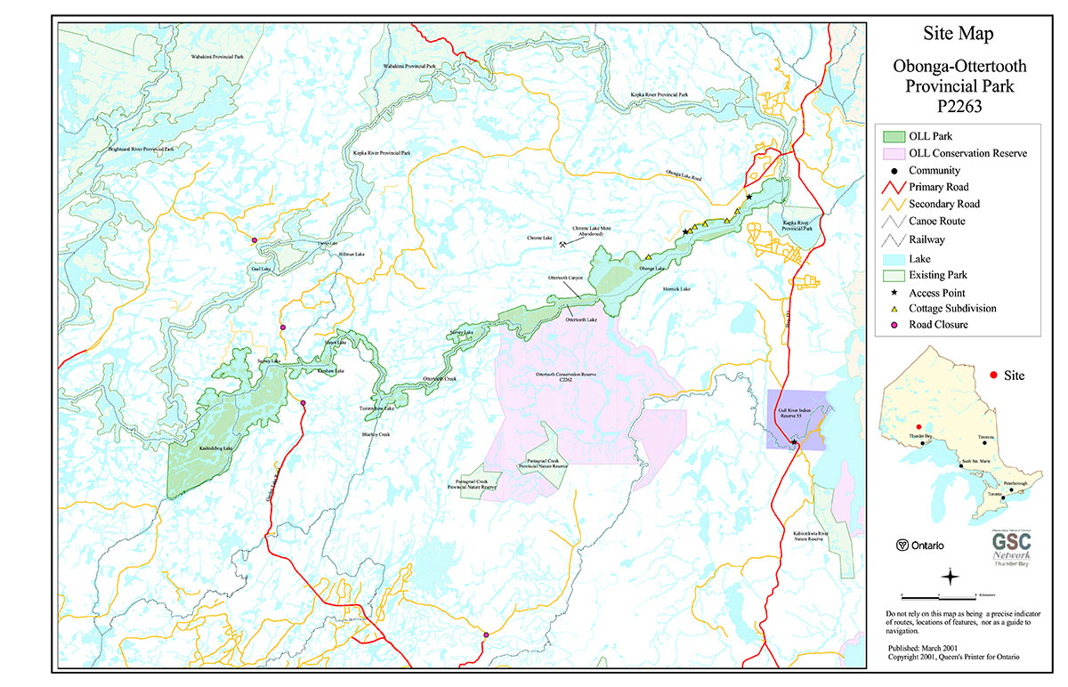
Obonga-Ottertooth Provincial Park contains all Crown Land. Generally the park’s boundary is 200 meters from water’s edge, except at a ridge feature on the south side of Obonga Lake, obvious landlock areas, patent lands and roads. Two waterway-class provincial parks, the Brightsand River and the Kopka River bound the park to the west and the northeast respectively. A large (26,782 ha) Ontario’s Living Legacy Conservation Reserve C2262 (Ottertooth) abuts to the south between Survey and the West Bay of Obonga Lakes.
The Armstrong Forest Management Unit (FMU) operated by Domtar Inc., and the Spruce River FMU operated by Abitibi-Consolidated Inc., surround Obonga-Ottertooth Provincial Park.
There are six (6) patent cottage subdivisions on the north side of Obonga Lake adjacent to the park, of which the majority are road accessible except for one subdivision deemed remote (water or trail access). A number of remote tourism outpost camps authorized under Land Use Permits (LUP) are located in the western portion. There are no known mining claims in the park. No transmission lines, gas pipeline corridors or major highways cross the park.
Guideline:
- No land disposition for the private use of individuals or corporations will be considered within the park. Small parcels of Crown land that support subsistence needs of existing adjacent cottages may be sold, providing park values are not affected
- Dispositions for uses associated with activities permitted in this IMS will be considered
- If any portions of contained or adjacent patent land become available, they will be considered for addition to the park
III Aboriginal interests
Obonga-Ottertooth Provincial Park area is within the boundaries of lands covered under the Robinson-Superior 1850 Treaty and Treaty 9 (western third). No First Nation Reserves lie adjacent to the park. The Gull Bay First Nation (I.R.#55) is located nearby. Ontario Parks understands that primarily Gull Bay First Nation has traditional interests within the park area. There are no land claims regarding Obonga-Ottertooth River Provincial Park at this time.
Guideline:
Any management guidelines will reflect the Ontario government’s approach to aboriginal rights:
- All decisions related to the identification, planning or disposition of provincial park lands, or other lands set aside to protect significant natural or cultural heritage values, will be the subject of public consultation. Aboriginal peoples who identify traditional ties to those lands will be integral to the consultation and decision making In some cases there may be a need for separate consultation or negotiation processes to address Aboriginal interest in park lands. If required, some issues regarding how a park is used may also be the subjects of negotiation with Aboriginal people
- The Government of Ontario will consider all the available options when seeking to determine the land component, if any, during negotiations involving land claim settlements with First Nations. Options for uses that involve lands, which are not to be considered for provincial park purposes, will be preferred
- As described in the Province’s Interim Enforcement Policy (1991), aboriginal people hunting or fishing in provincial parks will be subject to all relevant treaties and laws. However, an agreement reached between the Province and a First Nation may modify the application of those treaties and laws (Ontario Provincial Parks: Planning and Management Policies 1992)
IV Natural Resource Stewardship
Obonga-Ottertooth Provincial Park (21,190 ha) representing the ecological site districts of 3W-1, 3W-2 and 3W-3 (G.A. Hill, 1964) is characterized by the northern boreal forest, modified by forest fire. The most significant feature of Obonga-Ottertooth Provincial Park is the Ottertooth Creek canyon. East of Survey Lake, Ottertooth Creek cuts into the rim of the precipitous Nipigon Plate and drops almost 90 meters. The park contains a variety of earth and life science features including deep gorges and steep talus slopes, beaches, wetlands, moose aquatic feeding areas and near-by caribou habitat.
The Nipigon Plate of the Southern Province overlays the Archean intrusive rocks of the Superior Province just west of Obonga Lake, producing the canyons of Ottertooth Creek. The Nipigon Plate, to the east, is formed on relatively flat-lying Proterozoic mafic sills surrounding Lake Nipigon. Here, lacustrine deposits of the post-glacial era produced numerous beaches along the north shore of Obonga Lake. The portion of the park west of Obonga Lake is part of the Severn Upland of the Precambrian Shield and consists of bedrock exposures surrounded by thin and patchy glacial deposits (mostly ground moraines and glacial outwash) and muskegs. The relief is broad and rolling. The park lies north of the Kaiashk interlobate moraine.
Based on its geology, the park’s mineral potential is high within the portion of the park that has been delineated as the Obonga Lake volcanic greenstone belt. Of interest, though outside the park boundary is the abandoned Chrome Lake Mine site owned by Timminco Metals, located approximately 5-km northwest of the Northwest Bay of Obonga Lake. It has been closed since the 1940s. The presence of chrome has a strong association with and indicates high potential for the occurrence of platium group elements in the mafic-ultramafic intrusions.
Lands and waters
Due to its extremely rugged terrain and canyons in a remote setting, the park has high remote tourism values. The park has a unique position in terms of its watershed. The Kashishibog River between Hawn Lake and Tommyhow Lake is a primary division separating the Arctic and Atlantic Watersheds.
Guideline:
- Aggregate extraction is not permitted
- Peat extraction is not permitted
- Commercial hydro development is not permitted
- The need for any water control structures to enhance recreation water travel will be determined in the park management plan
- Mineral exploration may occur under controlled conditions in areas of the park identified as having provincially significant mineral potential (yet to be determined by MNR/MNDM). If a portion of the park is to be developed for a mine, it would be deregulated as part of the park, and appropriate replacement lands would be placed in regulation
Vegetation management
The Boreal Forest characterizes the park. The height of land weaves around Kashishibog Lake and hence Forest Regions of Canada (Rowe, 1972) separates the area into two forest sections ; Upper English River and Central Plateau. Extensive sand and gravel deposits and low rock outcrops provide a favorable environment for the prevalent jack pine and in the shallow swamps, black spruce. Due to human impacts, there is a trend to a mixed wood forest.
A huge 121,063 ha forest fire (TB#46) in 1980 altered the previous landscape both north and south of the waterway system, west of Obonga Lake to Kashishibog Lake. Currently, most forest stands surrounding the park are even-aged 20-year-old jack pine.
The park is located mainly within the Spruce River FMU 030 (Abitibi Consolidated Inc. SFL#542526) and a small portion in the Armstrong FMU 444 (Domtar Inc. SFL# 542255). For forest fire suppression purposes it lies in the Intensive Zone. Numerous forest management activities have taken place adjacent and within the park, with most harvesting occurring in the mid-1980's. There are no primary roads planned or cut blocks that impact the park in the 2001-2006 operations plan. A potential road crossing (Ottertooth), bisecting the Kashishibog River east of Kershaw Lake has been approved for future consideration in the Spruce River FMU. It is part of a long-term access strategy for areas in the caribou management zone, and is not expected for a minimum of 40 years.
Guideline:
- Commercial forest operations are not permitted.
- Fuelwood cutting is not permitted
- Insect/disease suppression of non-native infestations is permitted
- Suppression of natural and/or human-caused forest fires is permitted
- The need for a Vegetation Management plan, which will include prescriptions for fire management, will be determined in the park management plan
- In recently harvested areas within the park, renewal plans that satisfy industry commitments and that meet park objectives will be developed and implemented
Wildlife management
Obonga-Ottertooth Provincial Park contains significant habitat for and populations of Moose due to the large forest fire that swept through the area in 1980. Just west of Kashishibog Lake is a known Woodland Caribou calving area. The park falls within the Wildlife Management Unit 15B. Sport hunting for moose and small game is a popular activity throughout the area.
Guideline:
- Non-invasive wildlife monitoring may be permitted. The need for a Wildlife Management Plan will be resolved in the park management plan
- Sport hunting is permitted in Natural Environment zones, as determined through park management planning and subject to the relevant Ontario Hunting Regulations. Consideration of safety and conservation with respect to hunting will be made during park management planning with public involvement
Fisheries management
Obonga-Ottertooth Provincial Park has suitable angling opportunities for Walleye, Lake Trout and Northern Pike. Lake surveys were completed for Obonga, Kashishibog, and Kershaw Lakes in the 1970s. Obonga and Kershaw Lakes are identifed as cold water systems, Kashishibog and Tommyhow Lakes are identified as cool water systems, with the remaining lakes as unknown systems (ARA, 1999). In terms of sport fishing regulation, Division 22 of the Ontario Recreational Fishing Regulations Summary applies to Obonga-Ottertooth Provincial Park.
Guideline:
- Non-invasive fisheries monitoring may be permitted. The need for a Fisheries Management Plan will be resolved in the park management plan
- Sport fishing is permitted subject to the relevant Ontario Sport Fishing Regulations
- The possession/use of baitfish for sport fishing is a non-conforming use as park policy states it is prohibited. Decisions on this issue will be determined during park management planning
- Aboriginal and Treaty Rights to fish are not affected
V Cultural resources
There are no documented archeological sites, as this area has never been studied, but the potential is relatively high based on there being two undocumented pictograph sites within the Ottertooth Creek system.
Guideline:
- Further inventory is required to assess the cultural resources of Obonga-Ottertooth Provincial Park. Approved archeological fieldwork will be encouraged
- The locations of any archeological sites will not be public information. Necessary measures (access/development restrictions) to protect the integrity of any archeological sites will be implemented
- The need for a Cultural Resources Plan/Strategy for cultural features/sensitive areas will be determined with park management planning
VI Existing/proposed development
The most prevalent existing development adjacent to or within Obonga-Ottertooth Provincial Park are seasonal cottages on Obonga Lake and remote tourism outpost camps towards the west end of the park. Recreation plays a significant role in the park. There are two access points to water on the north side of Obonga Lake.
There are upward of a hundred cottages (subdivision M240, M348, M384, M385, M386, and M411) on the north shore of Obonga Lake, a long and narrow lake of 2,895 ha surrounded by high rolling hills. The local cottage-owners operate a waste disposal site outside the park boundary at the east end of Obonga Lake.
There are no authorized snowmobile trails in the park. There are no significant logging roads contained in the park. There are a number of boat caches (approximately 6 were noted during an aerial survey) associated with the remote tourism outpost camps. The locations and number of these boats vary, as the MNR Thunder Bay District does not maintain a boat cache registry program.
Guideline:
- Development of access zones and car/backcountry campsites will be addressed via park management planning. Ontario Parks' signage is permitted
- Continuing custodial management for roads contained within the park and capital development of new/additional roads and trails will be determined through park management planning
- Existing and future road crossings of waterway class parks for forest operations outside park boundaries are permitted subject to provisions of the Environmental Assessment Act. The number of road crossing will be minimized where possible and they will be managed to reduce their impact on recreational and aesthetic values
- Boat caches fall under existing policy of land disposition. Currently, boat caches for the private use of individuals will be phased out by Jan 1, 2010. Boat caches for commercial tourism can be permitted if they are complementary to the park objectives, and if supported by public consultation via the management planning process
- The use of snowmachines/all terrain vehicles (ATV) is covered under Section VII – Recreation Activities
- Fur Harvesting and related activities are outlined in Section VIII – Commercial Activities
VII Recreation activities
Obonga-Ottertooth Provincial Park possesses significant recreation values that include opportunities for backcountry canoeing, and traditional lake activities such as boating, angling and beach swimming. Anglers and hunters use the various remote outpost camps, using motorboats to access the lakes for fishing and wetlands for hunting. The main users of the area are from the Thunder Bay region, with non-residents utilizing the outpost camps.
Obonga-Ottertooth Provincial Park offers challenging, and remote canoeing opportunities. The waterway plays host to portions of three documented canoe routes as outlined in the Graham Area Canoe Routes Brochure (Routes 5, 6 & 9). These routes also connect the park with the Kopka River Provincial Park to the east and Brightsand River Provincial Park to the west. Information is provided on portages, campsites and points of interest, however there is no regular maintenance of the canoe routes. Route #9 passes through the Ottertooth Creek canyon and presents the canoeist with severe travel obstacles and minimal campsites. However, one is rewarded with unusual and spectacular scenery of rapids, waterfalls, talus boulders and steep canyons. Few people travel this area.
At the other end of the spectrum, the beaches on the north shore of Obonga Lake are popular summer swimming, picnicking and camping spots. The lake is a popular location for winter ice fishing as well as spring walleye fishing. By snowmachine, winter anglers access a prime Lake Trout lake, Hornick Lake (located outside the park) via Obonga Lake.
Guideline:
- Park management planning will determine policies for recreation management, including camping and canoeing
- Motorized land vehicles, aircraft and watercraft (private and commercial) may be permitted in certain management zones subject to park management planning. Motor size restrictions can be imposed
- The use of ATVs and snowmobiles on existing authorized trails will be permitted to continue subject to prescriptions determined through park management planning. New trails will be determined through park management planning
- Self-guided nature appreciation and wildlife observation are permitted
- Sports fishing and hunting are addressed under Section IV – Natural Resource Stewardship
VIII Commercial activities
There are seven outpost camps under Land Use Permits (LUPs), located on Kashishibog, Kershaw, Tommyhow, Survey Lakes and Ottertooth Creek. Five of these camps are owned by Holinshead Lake Resort, one by Ignace Outposts Ltd., and one by Kashabowie Outposts Ltd.
There are five (5) active Bear Management Areas (BMAs) within the park, held by three individual operators They are identified as TB-15B-002, TB-15B-007, TB-15B-009, TB-15B-010 and TB-15B-052. There are six (6) active commercial traplines (NG 21, 26, 31 and TB 49, 173, 184) located within the park, with one trap cabin located on Kashishibog Lake. Small game animals trapped include Lynx, Timber Wolf, Coloured Fox, Mink, Pine Marten, Beaver and Muskrat. The length of trapping season is animal specific and regulated under the Summary of the FurManagement Regulations .
The park contains wholly or partially the following baitfish harvest blocks: 501891; 498891; 498892; 498893, plus 66, 79, 89 and 95. Baitfish block 89 and 95 are currently not allocated and two main operators actively use the remaining blocks.
The park straddles both the Spruce River (FMU 030) and Armstrong (FMU 444) Forest Management Units.
Guideline:
- Existing authorized tourism facilities can continue, subject to management prescriptions determined through park management planning. New tourism facilities and expansion of existing facilities may be considered through the management planning process
- No new BMA areas will be permitted. An existing authorized BMA licence may be renewed or transferred subject to park management planning
- Existing trap line operations can continue indefinitely except in Nature Reserve zones as determined through park management planning. No new operations permitted, including new cabins, trails and reissuing vacant or lapsed trap lines. Transfer may take place if the surrender is accompanied by a request to be immediately reissued.
- Trap cabins will be relocated outside the park if the opportunity exists. Snowmobile trails used for access to trap lines are permitted
- Status Indians exercising treaty rights are permitted to continue trapping, subject to applicable legislation and regulation
- Existing bait harvesting is permitted to continue indefinitely, subject to possible conditions identified in subsequent Provincial Park and/or Fisheries Management Plans. No new bait harvesting licenses will be permitted, but active licenses may be transferred where it’s an established permitted use
- Commercial forest operations are not permitted
IX Access
Access into Obonga-Ottertooth Provincial Park can be gained from a tertiary road off the Obonga Lake Road that extends west from Secondary Highway 527. This road is maintained by the local Roads Board to provide access to the majority of the cottages. One remote subdivision gains access by boat or ATV trail via the cottage road. There are two public access points to water (graveled boat launch) off of the Obonga Lake Road that accommodate relatively large motorboats.
The Garden Lake Road (Hwy 811) previously bisected the park between Savage and Kershaw Lakes. The river crossing has been removed along with the road scarified 2-km on both sides. The road is posted "closed to public access to Kashishibog and Kershaw lakes", 9-km north and 9-km south of the Kashishibog River for remote tourism purposes.
Approximately 1-2 km south of this road closure posting on Garden Lake Road is an ATV trail that accesses the trap cabin on Kashishibog Lake. Illegal access to the park may be occurring at this location. In the far southwest corner of the park, the Empire Road off of the Graham Forest Access Road passes within 1-2 km of the park at the southwest end of Kashishibog Lake. It is not known if this trail is used for access in summer or winter by snowmobile.
Guideline:
- Access into the park from existing roads will be permitted to continue pending park management planning. No new access to the park will be created from roads adjacent to the park until resolved via park management planning
- Decisions on new roads, parking facilities and long-term management of roads abutting/crossing park lands will be clarified via park planning when access zones are delineated. Future road access to private lands will be allowed to encroach within the park where no suitable access alternatives exist
- Access by Aboriginal people exercising their Aboriginal or Treaty rights is not affected
X Client services
There are currently no client services for Obonga-Ottertooth Provincial Park. Canoe route information is available from Chaltrek Camping and Geological Supplies Inc. in Thunder Bay or by contacting the Thunder Bay Canoe and Kayak Club.
Guideline:
- Client services will be limited to a map/brochure until an approved park management plan is completed. Development of a Natural Heritage Education Plan will be considered when developing the park management plan
XI Research and inventories
Reconnaissance-level earth and life science inventory is still required for this park. Two permanent sample plots (Forest Growth and Yield Trial NP-94-06 and NP-94-07) are located adjacent to the park on the northeast shore of Obonga Lake. To ensure permanence of plot integrity, there is a 10 ha protective buffer surrounding each plot.
Guideline:
- Earth science, life science, cultural and recreation values inventories will be undertaken when funding permits
- Additional research / inventories to document park values will be permitted if not in conflict with park values and consistent with the Ontario Parks Research and Information Strategy
- Research projects may be undertaken by MNR, Ontario Parks or outside groups and individuals. The Park Superintendent / Zone Manager must approve all research applications
XII Marketing
Marketing of Obonga-Ottertooth Provincial Park has to date been limited to Ontario Living Legacy initiatives.
Guideline:
- When resources are available, Ontario Parks will promote Obonga-Ottertooth Provincial Park with the methods used for the other parks in the Northwest Zone. These include the Parks' Guide, tourist trade shows, and "friends of…" organizations
- A park management plan may direct that a Marketing Plan be developed. The scope of this plan would include provincial, national, and international markets
XIII Sources/references
Ministry of Natural Resources. 1999. Ontario’s Living Legacy Land Use Strategy.
Ministry of Natural Resources. 1998. Boreal West Round Table Draft Recommendations.
Ministry of Natural Resources. 1992 update. Ontario Provincial Parks: Planning and Management Policies.
Ministry of Natural Resources. 2000. NRVIS – Thunder Bay District.
Ministry of Natural Resources. 1999. Fisheries Data Capture Project for Thunder Bay District.
Ministry of Natural Resources. 1983. Thunder Bay District Land Use Guidelines (DLUG).
Ministry of Natural Resources. 1983. Nipigon District Land Use Guidelines (DLUG).
Ministry of Natural Resources. 1989. Thunder Bay District Fisheries Management Plan 1989-2000.
Ministry of Natural Resources. 1989. Nipigon District Fisheries Management Plan 1989-2000.
Ministry of Natural Resources. 2000. Recreation Inventory Report: Whitesand Provincial Park (Moore and Whyte).
Ministry of Tourism, Culture and Recreation. 2001. Pers. Comm. (Jan 4/01) / Archeological Files Regional Archeologist (Bill Ross).
Ministry of Northern Development and Mines. 1999. Mineral Resource Assessments for the Lands for Life Process (Resident Geologist files).
Ministry of Northern Development and Mines. 1991. Geology of Ontario; Special Volume 4 Part 1.
Ontario Geological Survey. 1983. NOEGTS 25 – Gull River Area.
Ontario Geological Survey. 1970. Bedrock Geology of Ontario – Map 2199 (West-Central Sheet).
Hill, G.A. 1964 map update. Site Regions and Districts of Ontario.
Canadian Forestry Service. 1972. Forest Regions of Canada. (J.S. Rowe)
Domtar Inc. 2000. Armstrong Forest 2000-2020 Forest Management Plan.
Abitibi-Consolidated Inc. 2001. Spruce River Forest 2001-2021 Forest Management Plan.
Maps
Map 1: Regional Context Obonga-Ottertooth Provincial Park P2263
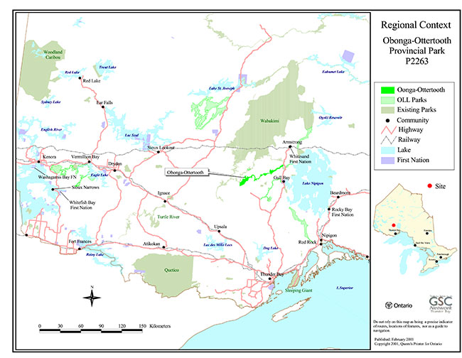
Enlarge Map 1: Regional Context Obonga-Ottertooth Provincial Park P2263
Map 2: Site Map Obonga-Ottertooth Provincial Park P2263
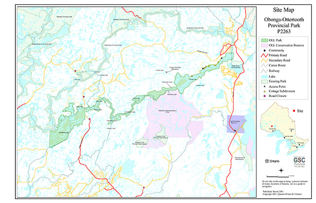
Enlarge Map 2: Site Map Obonga-Ottertooth Provincial Park P2263