Ogoki River Provincial Park Management Statement
This document provides policy direction for the protection, development and management of Ogoki River Provincial Park and its resources.
Interim Management Statement
©2003, Queen’s Printer for Ontario
Additional copies of this publication can be obtained from:
Nipigon District Office
Ontario Ministry of Natural Resources
5 Wadsworth, P.O. Box 970
Nipigon, Ontario
P0T 2J0
Telephone: 807-887-5000
Terrace Bay Area Office
Ontario Ministry of Natural Resources
P.O. Box 280
Terrace Bay, Ontario
P0T 2W0
825-3403
Geraldton Area Office
Ontario Ministry of Natural Resources
P.O. Box 640
Geraldton, Ontario
P0T 1M0
Telephone: (807)
And:
Ontario Parks Northwest Zone
Suite 221D
435 James Street South
Thunder Bay, ON
P7E 6S8
Telephone: 807-475-1321
Approval statement
This Interim Management Statement will provide interim direction for the management of the Ogoki River Provincial Park until a comprehensive Park Management Plan is prepared.
This statement will provide the basis for the subsequent preparation of the Park Management Plan.
I am pleased to approve this Interim Management Statement for Ogoki River Provincial Park.
Signed by:
Tim P. Sullivan
Zone Manager, Ontario Parks
Northwest Zone
Date: December, 2003
Prelude
The purpose of this Interim Management Statement is to identify:
- park values, which are to be protected
- resource management prescriptions necessary to protect these values in their current state; and
- restrictions, according to existing park policy, on use of natural resources within the park
This Interim Management Statement is not intended to replace a Park Management Plan. Rather it is intended to guide the use of natural resources and related activities within the park until such a time as a Park Management Plan is prepared.
The guidelines that have been developed are based upon information contained in the Ontario Provincial Parks Planning and Management Policies (1992) and Ontario’s Living Legacy Land Use Strategy (1999).
Background information
Refer to the maps at the end of the document.
| Name: | Ogoki River Provincial Park |
|---|---|
| Classification: | Waterway |
| MNR District: | Nipigon |
| MNR Region: | Northwest |
| Total Area (ha): | 23,459 |
| Ecoregions/Ecodistricts: | 2W-2, 2W-3, 3W-1 |
| Date In Regulation: | Target (2004) |
Life science representation
Landform/Vegetation representation analysis
A representation analysis (Lipsett-Moore et.al, in prep.) in 2003 of the Landform/Vegetation (L/V) Classes within the ecodistricts applicable to Ogoki River Provincial Park reveals important contributions to representation benchmarks for Ecodistrict 2W-3. The park makes far fewer contributions to benchmarks in Ecodistrict 2W-2 and 3W-1.
Ecodistrict 2W-2
The park contributes to approximately 10 % (8/79) of the Ecodistrict’s L/V Classes. The following L/V types within Ogoki River Provincial Park make an important contribution (i.e., at least 20%) to achieving L/V representation benchmarks within Ecodistrict 2W-2:
- Bedrock-Dense Deciduous Forest
- Bedrock – Recent Burns
Ecodistrict 2W-3
The park contributes to 73% (64/88) of the Ecodistrict’s L/V Classes. The following L/V types within Ogoki River Provincial Park make an important contribution (i.e., at least 20%) to achieving L/V representation benchmarks within Ecodistrict 2W-3:
- Bedrock – Open Bog
- Bedrock – Open Fen
- Bedrock – Mixed Forest – mainly Deciduous
- Bedrock – Mine Tailings, Quarries, and Bedrock Outcrop
- Bedrock – Sparse Deciduous Forest
- Glaciolacustrine Deposits – Mixed Forest – mainly Deciduous
- Glaciolacustrine Deposits – Open Fen
- Organic Deposits – Dense Coniferous Forest
- Organic Deposits – Dense Deciduous Forest
- Organic Deposits – Sparse Deciduous Forest
- Organic Deposits – Mixed Forest – mainly Coniferous
- Organic Deposits – Mine Tailings, Quarries, and Bedrock Outcrop
- Organic Deposits – Mixed Forest- mainly Deciduous
- Fluvial deposits - Dense Coniferous Forest
- Fluvial Deposits – Mixed Forest – mainly Coniferous
- Fluvial Deposits – Mixed Forest – mainly Deciduous
- Fluvial Deposits – Sparse Coniferous Forest
- Fluvial Deposits – Dense Deciduous Forest
- Fluvial Deposits – Open Bog
- Fluvial Deposits – Open Fen
- Fluvial Deposits – Treed Bog
- Fluvial Deposits – Treed Fen
Ecodistrict 3W-1
The park contributes to approximately 28% (23/83) of the Ecodistrict’s L/V Classes but makes no outstanding contributions (i.e., at least 20%) to achieving L/V representation benchmarks within Ecodistrict 3W-1.
Species / Communities
- Provincially and Regionally Significant Fauna: gull and tern nesting colonies, bald eagle and osprey nesting sites, woodland caribou calving areas, lake sturgeon habitat
- Regionally Significant Flora: sandbar willow, ovate spikerush
- Regionally Significant Community: seepage fen
- Forested Communities: jack pine-conifer forest (ES13), mixedwoods and trembling aspen forest (ES28, ES31)
- Wetland Communities: black spruce swamp (ES35, ES36), black ash (other hardwood) swamp (ES38), treed fen (ES40), thicket swamp (ES44), shore fen (ES45), meadow marsh (ES46), open water marsh (ES50)
ES =Ecosites (Racey et al. 1996)
Earth science representation
Geological theme
Bedrock Geology
- English River Subprovince
Surficial Geology
- Fluvial and Lacustrine Landforms and Processes
Feature(s)
Bedrock Features
- plutonic and gneissic or migmatitic meta-sedimentary rocks; Proterozoic-aged diabase dikes (MacKenzie swarm)
Surficial Geology Features
- Glaciolacustrine deposits; till with fossiliferous limestone clasts sourced from James Bay lowlands; active beaches; aeolian dunes, moraines and eskers; Anastomosing (interlaced) river; extensive delta system
Cultural resource representation
| Cultural Resource Representation | Theme Segment |
|---|---|
| Unknown | Unknown |
Recreational opportunities
| Day Use | Car Camping | Wilderness / Backcountry |
|---|---|---|
| N/A | N/A |
|
Inventories
| Level / Type | Reconnaissance / Completion Date | Detailed / Completion Date | Required |
|---|---|---|---|
| Earth science | February 2002 | No | Yes |
| Life science | Life science | No | Yes |
| Cultural | No | No | Yes |
| Recreational | No | March 2003 | No |
| Other | N/A | N/A | N/A |
I Introduction
Ogoki River Provincial Park (P2220) was established as part of Ontario’s Living Legacy (OLL), a land use strategy that was developed to guide the planning and management of Crown lands in the central and northern portions of Ontario. Under this initiative, released in July 1999, 378 new protected areas were identified.
Ogoki River is designated as a Waterway class park in recognition of its natural features, recreational water route and ability to provide high quality recreational and educational experiences. At 23,459 hectares and approximately 140 kilometres in length, this park includes a diversity of upland and wetland vegetation features, as well as a number of glacial features. The park is located east of the Ogoki Reservoir, approximately 80 kilometers north of Nakina and 150 kilometers north of Geraldton.
The park will serve as an important recreational waterway, offering remote tourism and recreation opportunities such as angling, hunting, wildlife viewing and canoeing in a scenic environment.
II Land tenure/acquisition/disposition
Ogoki River Provincial Park is composed entirely of Crown land in the Territorial district of Thunder Bay. The park begins at the Waboose Dam, at the east-end of the Ogoki Reservoir, and includes the Ogoki River to the eastern boundary of the Ontario Ministry of Natural Resources' (OMNR) administrative district of Nipigon. The Ogoki River forms two distinct branches east of Patience Lake. The park includes the southern arm of the river until Esser Lake and the northern arm until the district boundary. The park boundary has generally been set at 200 meters from the water’s edge.
There are no private in-holdings in the park, nor is there any adjacent patent land. A number of Land Use Permits (LUPs) have been granted for commercial outpost camps, and temporary commercial hunt camps. One LUP for a commercial outpost has been granted in the northern arm of Ogoki Lake. This land has been excluded from the park.
Guideline:
- No new land disposition for the private use of individuals or corporations will be considered within the park
- Land disposition for commercial use may occur, under the authority of a land use permit or lease, subject to approval through planning
- Existing authorized facilities/operations are permitted to continue, subject to management prescriptions determined through planning. Existing tourism facilities may be eligible for enhanced tenure as decided through planning
III Aboriginal Interests
Ogoki River Provincial Park is within the boundaries of lands covered under the James Bay Treaty (Treaty 9). The closest First Nations to the park are Eabametoong (approximately 80 km northwest), Marten Falls (approximately 90 km northeast), and Aroland (approximately 60 km south), all of which are within the Treaty 9 Area. Cultural, Traditional, and spiritual sites have been identified in Ogoki River Provincial Park by local First Nations. There are currently no formal land claims regarding Ogoki River Provincial Park.
Guideline:
- Any management guidelines will reflect the Ontario government’s approach to Aboriginal rights:
- All decisions related to the identification, planning or disposition of provincial parklands, or other lands set aside to protect significant natural or cultural heritage values, will be the subject of public consultation. Aboriginal peoples who identify traditional ties to those lands will be an integral part of the consultation and decision making processes. In some cases there may be a need for separate consultation or negotiation processes to address Aboriginal interest in parklands. If required, some issues regarding how a park is used may also be the subjects of negotiation with Aboriginal people
- The Government of Ontario will consider all the available options when seeking to determine the land component, if any, during negotiations involving land claim settlements with First Nat Options for uses that involve lands not to be considered for provincial park purposes will be preferred
- As described in the Province’s Interim Enforcement Policy (1991), Aboriginal people hunting or fishing in provincial parks will be subject to all relevant treaties and la However, an agreement reached between the Province and a First Nation may modify the application of those treaties and laws (Ontario Provincial Parks Planning and Management Policies, 1992)
IV Natural Resource Stewardship
Flat lacustrine and ground moraine deposits, with frequent peatlands characterize Ogoki River Provincial Park, which is within Ecodistricts 2W-1, 2W-3 and 3W-1. Glacial landforms, including aeolian dune forms, eskers and ice-flow features contribute to the relief, soils and vegetation. A number of significant earth science values have been identified in Ogoki River Provincial Park. The park’s bedrock geology contains representation of some of Ontario’s few known occurrences of the McKenzie diabase swarm, the world’s largest Precambrian mafic dike swarm. A number of active beaches are also found in the park, including a fossiliferous beach with limestone clasts sourced from the James Bay lowlands and what appears to be the only known occurrence of a black amphibole beach in Ontario.
The life science features at Ogoki River are provincially significant, since a number of the landform- vegetation (LV) types found in the park are critical to meeting the representation targets for Ecodistricts 2W-1, 2W-3 and 3W-1. The park includes habitat, feeding areas and nesting/calving sites for a number of provincially significant and specially protected fauna (as defined by the Fish and Wildlife Conservation Act), such as woodland caribou, lake sturgeon, bald eagle, osprey, American white pelican, common and black terns. A number of regionally significant plants, animals and communities have also been recorded in the park.
Lands and waters
Ogoki River Provincial Park encompasses approximately 140 km of the Ogoki River system, including Ogoki Lake and, as a result, water makes up 40% of the park area. Three other lakes are also included in the park: Kayedon Lake, Harrogate Lake and Patience Lake. The Ogoki River is a narrow, deep, slow-moving river with a high sediment load that follows an anastomosing (i.e. inter-laced), rather than meandering, model. Rapids occur where the river crosses bedrock shelves and a particularly large set of rapids, known as Speckled Trout Rapids, is located between Harrogate and Patience Lake. An extensive delta and estuary system has developed where the river enters Ogoki Lake.
The Ogoki River Diversion Project, which was officially opened in 1943, diverts water from the Ogoki River south into the Little Jackfish River at the Waboose Dam. With twelve sluiceways, the Waboose Dam (located at the park’s western boundary) is the largest dam in the project and is 15.2m high and 518m wide. The entire project was designed to meet the increase in energy demands caused by the war effort and has improved water levels in the Great Lakes, although it has also caused a significant drop in water levels and an unnatural flooding regime in the Ogoki River.
The entire park is located within the meta-sedimentary English River Sub-Province of the Archean-age Superior Province. Two main types of bedrock associated with this sub-province occur within the park: plutonic rocks, varying from foliated tonalite to muscovite-bearing granitics, and migmatitic or gneissic meta-sedimentary rocks. Elements of the Proterzoic-age McKenzie mafic diabase swarm are also found around Ogoki Lake in the form of 1-5m wide, vertical diabase dikes.
Guideline:
- Aggregate extraction is not permitted in the park
- Commercial hydro development is not permitted
- Water control structures are permitted in certain zones in waterway class parks to perpetuate natural or cultural values or to enhance recreational opportunities. The need for any water control structures will be determined during the park management planning process
- Peat extraction is not permitted
- Mineral exploration and mining are not permitted in the park
Vegetation management
Ogoki River Provincial Park contains a wide diversity of upland and wetland vegetation types on organic, silty and sandy soils. The majority of the forested area (50%) is black spruce swamp, while the hardwood and mixedwood forest found on riverbanks, eskers, and other raised landforms occupy approximately 25% of the land base. Limited jack pine dominated stands are found in the park and are generally confined to eskers with coarse sandy soil. Bogs and fens make up less than 5% of the park, although they are more frequent beyond the park boundary, away from the influence of the river. Fire disturbance is limited, as recent burns make up less than 5% of the park’s land area.
A regionally, and potentially provincially, significant seepage fen community has been identified on Ogoki Lake, where it forms a narrow strip along the wet shore. The vegetation consists of royal fern with low shrubs, a diversity of herbs and graminoids and a number of plant species that are rare or absent elsewhere in the park. The park also includes a number of individual plant species that are of regional significance, including the sandbar willow, associated with riverbanks, and the ovate spikerush, found on an Ogoki Lake beach.
Ogoki River Provincial Park is located within the Ogoki Forest Management Unit (FMU # 415) and is currently licensed to Long Lake Forest Products.
Guideline:
- Commercial forest operations are not permitted in the park
- Fuelwood cutting is not permitted in the park
- In the absence of a Fire Management Plan for the park, the fire management objectives of the surrounding fire management zone will apply. All human caused fires will be suppressed
- The need for a Vegetation Management Plan, which will include prescriptions for fire management and caribou considerations, will be determined through park management planning
- Suppression of non-native insect/disease infestations is permitted
- Ontario Parks will act as a plan advisor and reviewer during the Forest Management Planning Process. This process ensures that park values and park-related values are recognized and that protection and mitigation measures are addressed in the development of the forest management plan
Wildlife management
A number of wildlife values including moose aquatic feeding areas have been identified within the park. Fur bearing mammals of Ogoki River Provincial Park are typical of the boreal forest and include; moose, woodland caribou, timber wolves, snowshoe hare, and Canada lynx.
A single bear management area (BMA # GE-18A-21) overlaps with a small portion of the park south of the river from the Waboose Dam to a point approximately 12 km downstream from the junction with the Ottertail River.
Nine registered trap lines overlap with portions of the park area. They include: GE-147, GE-148, GE-150, GE-152, GE-157, NG-65, NG-66, NG-67, and NG-68. Beaver, mink, marten, river otter, lynx, muskrat, red squirrel, weasel, fox, and wolf have all been recently harvested from these lines. Four registered trap cabins are located within the park, west of Ogoki Lake. Two additional cabins are located on Ogoki Lake and may be used by Native individuals, since there is no indication of their affiliation with a particular trap line.
Reconnaissance surveys conducted in the park revealed 45 species of birds. More detailed inventories will certainly confirm the presence of additional species. The provincially endangered American white pelican and the provincially vulnerable black tern have been observed in the park, while osprey and the provincially endangered bald eagle are known to nest in the area. Common terns have also been observed nesting in the park, which is an uncommon occurrence in the Thunder Bay Territorial District.
Five species of amphibians and reptiles were also observed in Ogoki River Provincial Park: eastern American toad, leopard frog, wood frog, red-sided garter snake and eastern garter snake. The red-sided garter snake and leopard frog are considered regionally significant.
Guideline:
- Non-invasive wildlife monitoring may be permitted
- The need for a Wildlife Management Plan will be addressed during future park management planning processes
- Sport hunting is presently permitted throughout the park, subject to the relevant Ontario Hunting Regulations. Restrictions on sport hunting may be imposed through park management planning
- Aboriginal and treaty rights to hunt are not affected
- Commercial bear hunting will be allowed to continue in areas of the park where it has traditionally occurred. When a management plan is approved, any hunting that is occurring in a nature reserve zone will be addressed through the management planning process consistent with OLL-LUS and Park Policies
- In situations where licenses have not been issued and inventories have been completed that identify candidate or probable nature reserve zones, licensing should not be issued for these areas
- No new commercial bear hunting operations will be permitted
- The issuance of licenses or permits for commercial trapping will be allowed where the activity has been licensed or permitted since January 1, 1992 unless:
- The government has taken action to discontinue the activity
- Proceeding would create/aggravate resource sustainability issues (e.g., wildlife management reasons, impacts on values in nature reserve zones) or
- Licensing or permitting should be deferred due to Aboriginal issues
- Status Indians exercising treaty rights are permitted to continue trapping, subject to applicable legislation and regulation
- Snowmachine trails used for access to trap lines are permitted
Fisheries management
Lake surveys were conducted on all of the major lakes in Ogoki River Provincial Park in the 1970's. These surveys identified several sport fish species including walleye, northern pike, lake sturgeon, yellow perch, and lake whitefish. A number of other fish species were found including white sucker, spottail shiner, Iowa darter, Johnny darter, logperch, redhorse sucker, longnose dace, sculpin, ninespine stickleback, burbot, lake chub, mimic shiner, trout-perch, fathead minnow. Although not encountered during the lake surveys, speckled (brook) trout have also been caught from the Ogoki River. Speckled trout spawning areas have been identified in the western portion of the park.
Sport fish in Ogoki Lake have been monitored for mercury contamination since the early 1980's. Consumption advice for most sizes of fish caught in the lake is detailed in the Guide to Eating Ontario Sport Fish, although anglers are generally cautioned against eating substantial amounts of large northern pike and walleye.
Seventeen baitfish blocks are wholly or partially contained within Ogoki River Provincial Park.
No commercial fishing licenses exist within Ogoki River Provincial Park.
Guideline:
- Fisheries monitoring may be permitted
- The need for a Fisheries Management Plan will be addressed during future park management planning processes
- Sport fishing is permitted, subject to the relevant Ontario Recreational Fishing Regulations. Restrictions on sport fishing may be imposed through park management planning
- Aboriginal and Treaty rights to fish are not affected by the designation of Ogoki River Provincial Park
- The issuance of licenses for baitfish harvesting will be allowed where the activity has been licensed or permitted since January 1, 1992 unless:
- The government has taken action to discontinue the activity
- Proceeding would create/aggravate resource sustainability issues (e.g, wildlife management reasons, impacts on values in nature reserve zones) or
- Licensing or permitting should be deferred due to Aboriginal issues
- Existing baitfish harvesting is permitted to continue indefinitely, subject to possible conditions identified in subsequent Provincial Park and/or Fisheries Management Plans. Active licenses may be transferred where it is an established permitted use
- The issuance of licenses for commercial fishing will be allowed where the activity has been licensed or permitted since January 1, 1992 unless:
- The government has taken action to discontinue the activity
- Proceeding would create/aggravate resource sustainability issues (e.g., wildlife management reasons, impacts on values in nature reserve zones) or
- Licensing or permitting should be deferred due to Aboriginal issues
- In accordance with Ontario Provincial Parks Planning and Management Policies (1992), live baitfish should not be used or possessed in this provincial park. Until such time as a regulation is established, Ontario Parks will discourage the use or possession of baitfish in Ogoki River Provincial Park
V Cultural resources
There are currently no registered archeological sites within Ogoki River Provincial Park. Some First Nations values have been inventoried through the Forest Management Planning process.
Guideline:
- The need for a Cultural Resources Plan/Strategy for cultural features/sensitive areas will be determined through consultation and cooperation with First Nations communities and park management planning
- Further inventory will be required to assess the cultural resources of Ogoki River Provincial Park. Approved archeological fieldwork will be encouraged
VI Existing/proposed development
Existing development within Ogoki River Provincial Park is associated with forestry, trapping, and remote tourism activities. One forest access road, known as the Ogoki Road, crosses the park approximately halfway between the Waboose Dam and the Ottertail River junction. One road crossing of the north branch of the Ogoki River for forestry purposes may be permitted where alternatives that do not cross the park are determined to be unacceptable through forest management planning. An evaluation of natural and cultural values will be required.
A number of trap line cabins and commercial outpost camps have been developed on the park’s major lakes and in the western portion of the park between the Waboose Dam and Ogoki Lake.
In 1980, the OMNR established an initial attack fire base southeast of the Ogoki Bridge. The base is not included within the park boundaries. The SFL holder has established a work camp near the Ogoki Road, just outside of the park boundaries.
Guideline:
- Existing tourism facilities and related activities will remain, subject to park management planning
- New tourism facilities may be considered only through park management planning
- Development of access zones will be addressed via park management planning
- Continuing custodial management for roads contained within the park and capital development of new/additional roads will be determined through park management planning
- Future road crossings for forestry operations outside park boundaries may be permitted, subject to provisions of the Environmental Assessment Act, through forest management planning
- New ATV and snowmobile trails may be considered during park management planning
- Guidelines for access roads are described in Section IX - Access
VII Recreation activities
Ogoki River Provincial Park is an important remote tourism area and provides high quality angling, hunting, canoeing and wildlife viewing in a scenic environment. The majority of the park’s visitors use the services of a remote tourism operator and stay in one of the park’s many outpost camps, although limited backcountry canoe camping does occur in Ogoki River Provincial Park. The park’s major attractions are fishing, hunting, and wildlife viewing opportunities (Barry 2003). The geographic significance of the park is high, given the large number of visitors from across Canada and the United States.
The majority of the Ogoki River Provincial Park is within Wildlife Management Unit (WMU) 17, although a portion of the park downstream of the Waboose Dam to just upstream from the Ottertail River is within WMU 18A. The entire park lies within the Northern Waterfowl District.
Guideline:
- Park management planning will determine policies for recreation management, including camping, boating and aircraft landing
- Motorized land vehicles and aircraft and watercraft (private and commercial) may be permitted in certain management zones subject to park management planning. Motor size restrictions may be imposed
- Ontario Parks will discourage the use or possession of live baitfish in this provincial park. Policies for the use of live baitfish in the Ogoki River Provincial Park will be determined through park management planning
- The use of snowmobile/all terrain vehicles on authorized trails, as designated by the Park Superintendent, will be permitted to continue subject to current road closures and prescriptions determined through park management planning
- Non-resident Crown Land Camping permit fees will apply
- No new boat caches are to be established for the private use of individuals
VIII Commercial activities
There are 10 commercial outpost camps in Ogoki River Provincial Park. Three of these camps are found along the river west of Ogoki Lake, while the remainder are on the park’s four major lakes: Ogoki Lake (3), Kayedon Lake (2), Harrogate Lake (1), and Patience Lake (1). A restricted LUP has also been issued to run a short term hunt camp in the vicinity of Amy Falls. A new LUP for commercial tourism has been issued on the northeast shore of Ogoki Lake. This area has been excluded from the park.
Guideline:
- Commercial activities within the park will be consistent with park policy
- New tourism facilities (or expansions to existing ones) may be considered through the park management planning process
- Fur harvesting activities are described in Section IV under Wildlife Management
- Fish harvesting activities are described in Section IV under Fisheries Management
IX Access
Access to Ogoki River Provincial Park is limited. Most visitors enter the park by water either by boat or by plane. Ogoki River is intersected by the Ogoki Road just east of Ogoki Falls. Travel is restricted north on the Ogoki Road, where it crosses the river, to protect remote tourism values.
Guideline:
- Decisions on new park-related roads, parking facilities will be clarified via park management planning
- New roads abutting the park are determined during forest management planning, reflecting the need to harmonize the Ogoki Forest Management Plan with the direction given in this IMS and future park management plans
- Aircraft landing on water may be permitted under the authority of a valid aircraft landing authorization as per O.Reg. 952/01,s.24(2) under the Provincial Parks Act
- Access by Aboriginal people exercising their Aboriginal or Treaty rights is not affected
X Client services
There are currently no client services for Ogoki River Provincial Park. Canoe route information is available from local tourist outfitters.
Guideline:
- Client services will be limited to a map/brochure until an approved park management plan is completed
XI Research and inventories
Reconnaissance earth and life science inventories were completed for the park in 2001. A detailed recreation resource inventory was completed in 2003. Additional surveys related to caribou were carried out in 2003. Cultural and historical features have yet to be inventoried.
Guideline:
- Detailed inventories of earth science, life science, and cultural resources will be undertaken when funding permits
- Additional research/inventories to document park values will be permitted if not in conflict with park values and consistent with the Ontario Parks Research and Information Strategy
- Discussions will be held with First Nation communities to determine the need to inventory Aboriginal cultural resources, and to develop appropriate strategies to conserve and manage these resources
- MNR, Ontario Parks or partnered groups and individuals may undertake research projects subject to the approval by the Park Superintendent and Ontario Parks Zone Manager
XII Marketing
Marketing of Ogoki River Provincial Park has been limited to the acknowledgement of its role in the Ontario’s Living Legacy Land Use Strategy and the provincial parks and protected areas system.
Guideline:
- The need for a Marketing Strategy will be identified through the park management planning process
XIII Sources/references
Barry, J. 2003. Recreation Resource Inventory Report – Ogoki River Provincial Park. Ontario Parks, Unpublished Report.
Gauthier, D. 2001. Earth Science Inventory Checklist: Ogoki River. Northern Bioscience Ecological Consulting.
Harris, A. and R. Foster. 2001. Ogoki River Natural Heritage Area – Life Science Checksheet. Northern Bioscience Ecological Consulting.
Lipsett-Moore, G., Bookey, N., Kingston, S. and J. Shuter. In Prep. Representation, Focal Species and Systematic Conservation Planning for the Northern Boreal Initiative. Ontario Parks, Northwest Zone.
Morrill, N.L. 2003. Caribou Calving – Ogoki Lake Report. Ontario Parks, Unpublished Report.
Ontario Ministry of Natural Resources (OMNR). 2002. Natural Resources Values Information System (NRVIS). Nipigon District, OMNR.
OMNR. 1999. Ontario’s Living Legacy Land Use Strategy. Queen’s Printer for Ontario.
OMNR. 1992 (update). Ontario Provincial Parks: Planning and Management Policies.
Racey, G.D., Harris, A.G., Jeglum, J.K., Foster, R.F. and G.M. Wickware 1996. Terrestrial and Wetland Ecosites of Northwestern Ontario. Queen’s Printer for Ontario, Thunder Bay.
Ross, W.A.. February 11, 2001. (Regional Archeologist, Ministry of Tourism, Culture and Recreation) Personal communication.
Policy Report - Ogoki River Provincial Park
Commercial activities
| Activity | Permitted? | Guidelines |
|---|---|---|
| Aggregate extraction | No | |
| Bait fishing (commercial) – existing | Yes |
No current baitfish harvesting licenses exist within the park.
|
| Bait fishing (commercial) – new | No | |
| Commercial fishing – existing | Yes | No commercial fishing operations currently exist within the park.
|
| Commercial fishing – new | No | |
| Commercial fur harvest – existing | Yes | Existing trap line operations can continue indefinitely. New operations, including trap line cabins and trails will not be permitted. The relocation of existing trails and cabins will be subject to ecological principles and management planning. Snowmobile trails used for access to the trap lines are permitted.
In situations where licenses have not been issued and inventories have been completed that identify candidate or probable nature reserve zons, licensing should not be issued for these areas. |
| Commercial fur harvest – new | No | |
| Commercial hydro development | No | |
| Commercial timber harvest | No | |
| Commercial Tourism (e.g. outfitting services, outpost camps, resorts/lodges) – existing | Yes | Existing authorized facilities/operations are permitted to continue, subject to management prescriptions determined through planning. Existing tourism facilities may be eligible for enhanced tenure as decided through planning. |
| Commercial Tourism (e.g. outfitting services, outpost camps, resorts/lodges) – new | Maybe | New facilities/operations may be considered through planning. |
| Energy transmission & communications corridors (new) | Maybe | Utility line crossings may be necessary to maintain essential public services. The number of new crossings will be minimized where possible and they will be managed to reduce their impact on recreational and aesthetic values. |
| Mineral exploration and development | No | |
| Commercial Wild rice harvesting – existing | Yes | |
| Commercial Wild rice harvesting – new | No |
Land and resource management activities
| Activity | Permitted? | Guidelines |
|---|---|---|
| Crown land disposition – private use | No | No land disposition for the private use of individuals is permitted, except for minor dispositions in support of existing uses (e.g., reconstruction of a septic system). All existing tenure issued by the Crown for private use, except private recreation camps, will be phased out no later than January 1, 2010 |
| Crown land disposition – commercial use | Maybe | Renewal of existing tenure for authorized commercial uses is permitted. Land disposition for commercial use may occur, under the authority of a land use permit or lease, subject to approval through planning. Existing tourism facilities may be eligible for enhanced tenure. |
| Fire suppression | Maybe | In the absence of a fire management plan for the park, the fire management objectives of the surrounding fire management zone will apply. All human-caused fires will be suppressed. |
| Fish habitat management | Maybe | May be considered through planning. |
| Fish stocking – native species | Maybe | May be considered through planning. |
| Fish stocking – non-native species | No | |
| Insect/disease suppression | Maybe | May be considered through planning. |
| Inventory/monitoring | Yes | |
| Personal use permits for wood harvesting | Maybe | Long-term management direction will be determined through planning. Existing authorized permits may continue on an interim basis for properties that do not have road access. |
| Prescribed burning | Maybe | May be considered through planning. |
| Roads (non-park use) - existing | Maybe | Access into the park from traditionally used roads (Ogoki Road) will be permitted to continue by authorized users pending park management planning. Existing road crossings (Ogoki Road) for forest management purposes are permitted. Conditions of use will be addressed in park management planning and forest management planning. |
| Roads (non-park use) - new | Maybe | New roads abutting the park are determined during forest management planning. No new access to the park will be created from adjacent roads until resolved via park management planning. Future road crossings for forestry operations outside park boundaries may be permitted, subject to provisions of the Environmental Assessment Act including park management planning and forest management planning. The number of crossings will be minimized where possible and they will be managed to reduce their impact on recreational and aesthetic values. |
| Vegetation management | Maybe | May be considered through planning. |
| Water control structure –existing | No | No structures exist. |
| Water control structure – new | Maybe | New structures may be considered through planning for recreation enhancement. |
| Wildlife population management | Maybe | May be considered through planning. |
Science, education & heritage appreciation
| Activity | Permitted? | Guidelines |
|---|---|---|
| Demonstration areas | Maybe | May be considered through planning. |
| Historical appreciation- self-guided | Maybe | Support facilities to be identified through planning. |
| Nature appreciation – self-guided | Maybe | Support facilities to be identified through planning. |
| Photography and painting | Maybe | Support facilities to be identified through planning. |
| Research | Yes | Subject to authorization. |
| Wildlife viewing | Maybe | Support facilities to be identified through planning. |
Recreation activities and facilities
| Activity | Permitted? | Guidelines |
|---|---|---|
| Aircraft landing (water) | Maybe | Under the authority of a valid aircraft landing authorization, as per O. Reg. 952/01, s. 24(2) under the Provincial Parks Act. |
| ATV use – on trails | Maybe | The use of snowmobile/all terrain vehicles on authorized trails, as designated by the Park Superintendent, will be permitted to continue subject to current road closures and prescriptions determined through park management planning. |
| ATV use – off trails | No | |
| Camping | Maybe | Long-term management direction for camping facilities will be determined through park management planning. Existing use may continue in the interim, unless park values are threatened. |
| Horseback riding (trail) | Maybe | Long-term management direction will be determined through planning. Existing use may continue in the interim, unless park values are threatened. No authorized trails exist. |
| Hunting | Yes | Subject to regulation under the Fish and Wildlife Conservation Act. Consult the Ontario Hunting Regulation Summary for specific local details. Hunting may be restricted in certain zones as determined through park management planning. |
| Mountain bike use | Maybe | Long-term management direction will be determined through planning. No authorized trails exist. |
| Motor boat use – private | Maybe | Long-term management direction for private motor boat use will be determined through management planning. Existing use may continue in the interim, unless park values are threatened. Consult regulations under the Provincial Parks Act for specific local details. |
| Motor boat use – commercial | Maybe | Long-term management direction for commercial motor boat use will be determined through management planning. Existing use may continue in the interim, unless park values are threatened. Consult regulations under the Provincial Parks Act for specific local details. |
| Non-motorized recreation travel (canoeing, kayaking, hiking, cross-country skiing, snowshoeing) | Maybe | Long-term management direction will be determined through planning. Existing uses may continue in the interim, unless park values are threatened. No authorized trails for hiking or skiing exist. |
| Private recreation camps ("hunt camps") – existing | No | None exist. |
| Private recreation camps ("hunt camps") – new | No | |
| Rock climbing | Maybe | Long-term management direction will be determined through planning. Rock climbing is permitted only in areas designated for that purpose by the Park Superintendent as per O. Reg. 952/01, s. 5.1 under the Provincial Parks Act. No areas are currently designated. |
| Sailing and sailboarding | Maybe | Long-term management direction will be determined through planning. Existing uses may continue in the interim, unless park values are threatened. |
| Scuba and skin diving | Maybe | Long-term management direction will be determined through planning. Existing uses may continue in the interim, unless park values are threatened. |
| Snowmobiling – on trails | Maybe | The use of snowmobile/all terrain vehicles on authorized trails, as designated by the Park Superintendent, will be permitted to continue subject to current road closures and prescriptions determined through park management planning. |
| Snowmobiling – off trails | No | |
| Sport fishing | Yes | Consult the Ontario Recreational Fishing Regulations Summary for specific local details. In accordance with Ontario Provincial Parks Planning and Management Policies (1992), live baitfish should not be used or possessed in this provincial park. Until such time as a regulation is established, Ontario Parks will discourage the use or possession of baitfish in Ogoki River Provincial Park. |
| Trail development | Maybe | Certain trails may be considered through planning. |
Maps
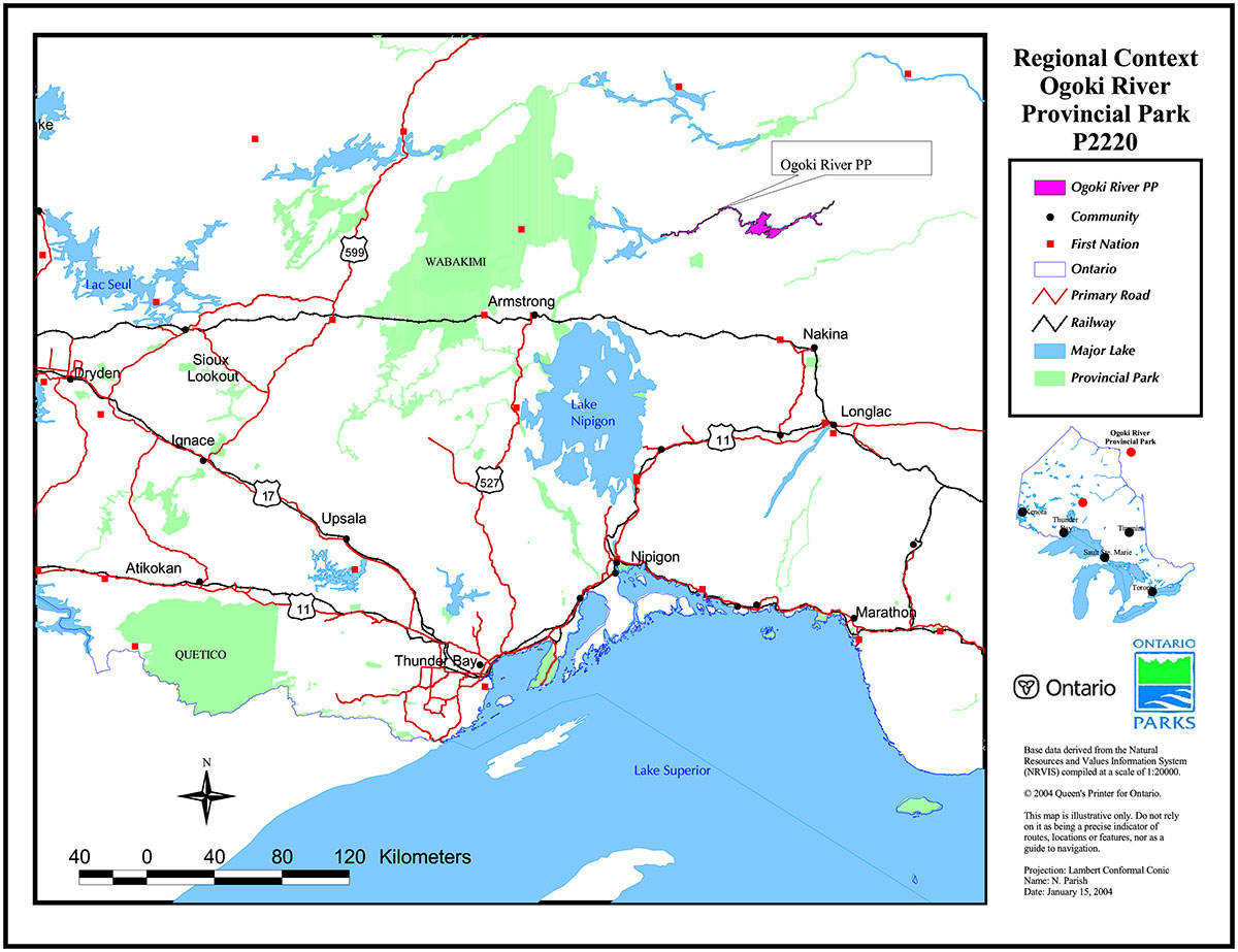
Figure 1: Regional context Ogoki River Provincial Park P2220
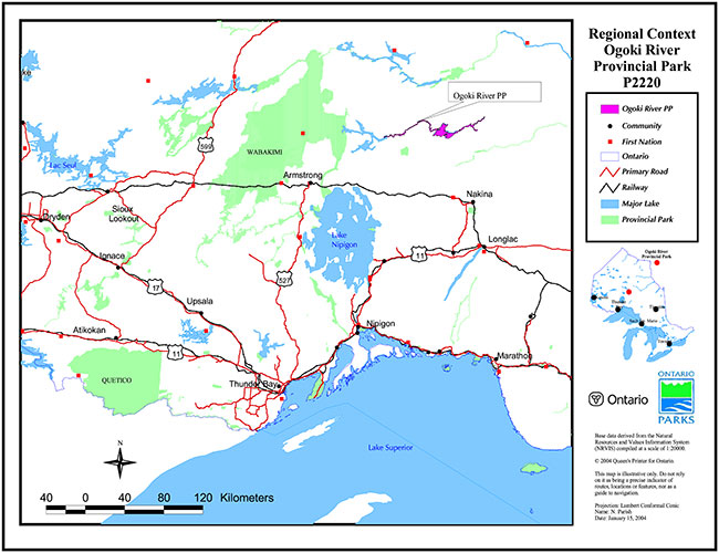
Enlarge Figure 1: Regional context Ogoki River Provincial Park P2220
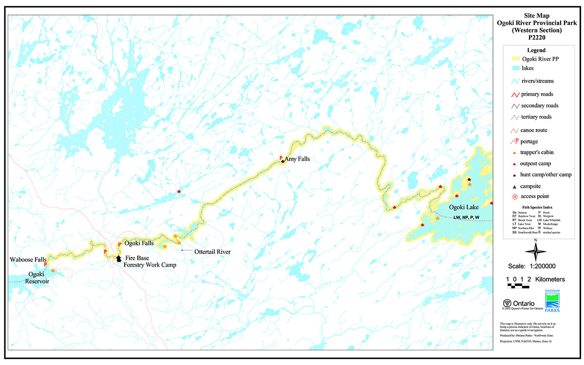
Figure 2: Site Map Ogoki River Provincial Park (Western Section) P2220
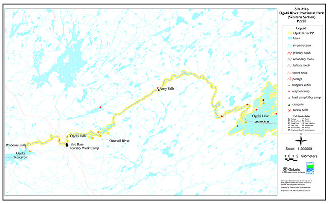
Enlarge Figure 2: Site Map Ogoki River Provincial Park (Western Section) P2220
Figure 3: Site Map Ogoki River Provincial Park (Eastern Section) P2220
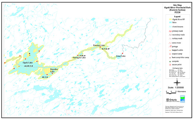
Enlarge Figure 3: Site Map Ogoki River Provincial Park (Eastern Section) P2220