Ouimet Canyon Provincial Park Management Plan
This document provides policy direction for the protection, development and management of Ouimet Canyon Provincial Park and its resources.
Note: This document has been scanned and formatted, and therefore is slightly different from the original version. -March 2002
Additional copies of this publication are obtainable only from:
Thunder Bay District Office
P.O. Box 5000
Thunder Bay, Ontario
P7C 5G6
Telephone: (807) 475-1531
© 1985 Government of Ontario
Approval statement
Ouimet Canyon, designated as a Provincial Nature Reserve, is widely regarded as one of the most spectacular natural features in northwestern Ontario. Its grandeur and relative close proximity to Highway 11/17 makes it one of the prime tourist attractions for travellers visiting sites along the north shore of Lake Superior. In addition to the opportunities it provides for the many tourists to visit, view and photograph the magnificent scenery each year, the Nature Reserve ensures protection for the habitat of arctic-alpine plant species on the canyon floor.
We are pleased to approve the Ouimet Canyon Provincial Nature Reserve Management Plan as official policy for the management and development of this park. The plan reflects this Ministry’s intent to protect the natural features of Ouimet Canyon Provincial Nature Reserve, and develop high quality opportunities for day-use recreation and heritage appreciation for residents of Ontario and visitors to the Province.
Signed by:
G.P. Elliott
Regional Director
North Central Region
Date April 15, 1985
Signed by:
N.R. Richards
Director
Parks and Recreational
Areas Branch
Date April 2, 1985
1.0 Introduction
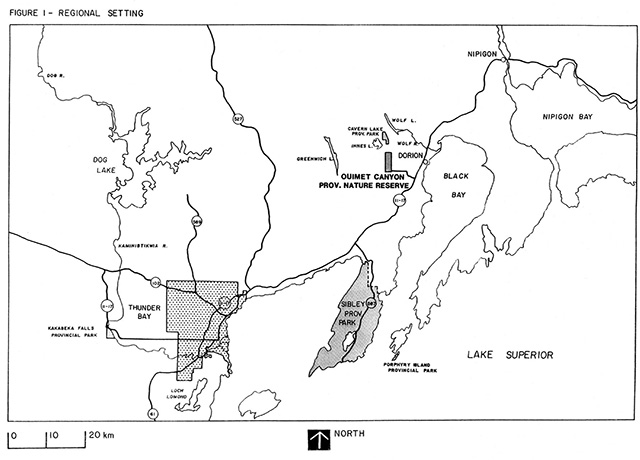
Ouimet Canyon Provincial Nature Reserve is located in Dorion Township, about 10 km (6.2 mi.) west of Dorion and 60 km (37 mi.) northeast of the city of Thunder Bay (figure 1). Access from Highway 11-17 (the Trans-Canada Highway) is via the Innes Lake road, a distance of 13 km (8 mi.).
The nature reserve’s 777 ha (1,920 ac.) encompasses a representative portion of the diabase-influenced landscape typical of the Thunder Bay-Nipigon area of Ontario. The nature reserve is noted primarily for the grandeur of the steep-walled bedrock canyon for which it is named, a feature not unique to this region, but one unmatched for its size, accessibility and visual impact. The floor of the canyon harbours a cold-climate flora, which represents relicts of a post-glacial environment isolated and preserved through the protection of the canyon walls. The nature reserve is located in the Superior Section of the Boreal Forest Region and lies in Hills' (1959) Site District 3 in Site Region 3W.
A short pedestrian loop trail leads visitors to the viewing platforms overhanging the canyon rim. Interpretive display panels enroute highlight the significant natural features of the nature reserve.
The Ouimet Canyon Provincial Nature Reserve master plan was approved in 1975 to guide future management activities. The periodic review of a management plan (formerly master plan) is an essential stage in the planning process to ensure that the plan remains current and relevant. Also, reviews provide an opportunity for evaluation of progress made to date' and for public consultation on any aspect of park management. This document, as formulated through the review process, replaces the former master plan and will guide the management of Ouimet Canyon Provincial Nature Reserve until the next review.
2.0 Park policy
2.1 Goal
To protect Ouimet Canyon Provincial Nature Reserve which contains an environment of geological and biological significance, for the scenic enjoyment, education and scientific benefit of the people of Ontario.
2.2 Objectives
Nature reserve parks contribute to the protection and heritage appreciation objectives of the provincial park system. In this regard Ouimet Canyon Provincial Nature Reserve will contribute to the achievement of the following objectives:
2.2.1 Protection
To protect provincially significant elements of the natural and cultural landscape of Ontario.
The distinctive canyon formation has created a unique microclimatic condition, allowing arctic, sub-arctic and alpine plants to persist in an area outside their normal range. In addition to the special nature of the flora, the park contributes to the representation of vegetation in Site District 3 (Site Region 3W). The canyon formation represents the typical structural and erosional conditions characteristic of the area. It is unusual, however, because of its large size.
Figure 1 – Regional setting
Enlarge figure 1 regional settings map
2.2.2 Heritage appreciation
To provide opportunities for exploration and appreciation of the natural and cultural heritage of Ontario.
A loop trail offers the visitor an opportunity to experience the scenic grandeur of Ouimet Canyon. Trail-side display panels provide an interpretation of the significant natural features such as the geological formation and the arctic-alpine plants.
Over the years, Ouimet Canyon Provincial Nature Reserve has become a significant tourist attraction in the area. Estimated visitation in 1984 totalled 9,200 vehicles (approximately 31,400 visitors). Through the heritage appreciation objective the park will continue to play an important role in providing quality tourism opportunities.
2.3 Classification
Ouimet Canyon Provincial Nature Reserve will continue to be classified as a nature reserve park, one of six classes of Ontario provincial parks.
The Ontario Provincial Parks policy (Ontario Ministry of Natural Resources, 1978a) defines nature reserve parks as:
areas selected to represent the distinctive natural habitats and landforms of the Province, and are protected for educational purposes and as gene pools for research to benefit present and future generations.
The canyon formation, together with the occurrence of disjunct arctic-alpine flora, are truly distinctive, making Ouimet Canyon Provincial Nature Reserve a significant part of the provincial park system.
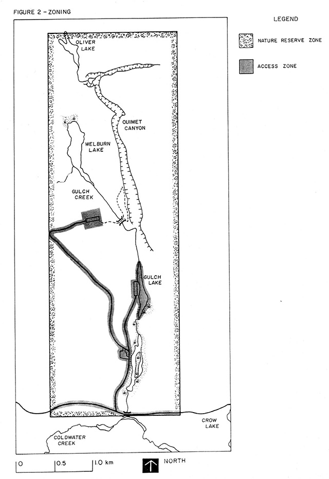
2.4 Zoning
Two types of zones have been designated to guide the management of Ouimet Canyon Provincial Nature Reserve, a nature reserve zone and an access zone (figure 2).
2.4.1 Nature reserve zone
One nature reserve zone (721 hectares, 1,781 acres) encompassing most of the park area will protect natural features for their intrinsic values, interpretation and scientific study.
The canyon formation and the relict arctic, sub-arctic and alpine plants are all contained within this zone. The Ouimet Canyon trail and viewing pods are located in a small area on the canyon’s west rim, within this zone.
Figure 2 - Zoning
2.4.2 Access zone
One access zone will serve as a staging area where minimal facilities support use of the nature reserve zone.
A 3 km (2 mi.) access road and a parking lot at the head of the interpretive trail are the main components of this zone. The portion of the zone containing the access road will be defined as "that area adjacent to the road, for a distance of 25 meters from the centerline of the road." This definition recognizes that realignment will be required to upgrade the road for hard surfacing. The zone has been enlarged slightly in the area of the upper parking lot to allow for possible future development (e.g. expansion of the parking lot, additional washroom facilities, a maintenance area). The extent of the zone is depicted in figure 2.
Two additional facility areas, the Gulch Lake picnic area and a lower trailer parking lot, will be re-evaluated to determine a need for them in the future.
3.0 Resource management
Ouimet Canyon Provincial Nature Reserve will be managed in accordance with the policies outlined below. These policies are consistent with the guidelines provided in "Ontario Provincial Parks Planning and Management Policies" (Ontario Ministry of Natural Resources, 1978b) for nature reserve class parks.
Although the policies are presented in separate categories, all planning and management will recognize that the components are inter-related and that an integrated approach will be required in order for park objectives to be achieved.
3.1 Land and water
There will be no specific management of land and water resources outside the access zone unless human safety, park facilities or resources are endangered.
In the interest of safety and resource protection, all pedestrian traffic will be discouraged along the canyon rim beyond the viewing pods and interpretive trail except to those who have acquired a research permit or written permission of the District Manager, Ministry of Natural Resources.
3.2 Vegetation
The management of vegetation will be directed to the maintenance of an evolving natural succession.
Commercial forest operations will not be permitted. In the access zone trees may be removed for development, management or safety purposes. In the portion of the nature reserve zone where the interpretive trail is located, trees may be removed for safety purposes.
During landscape rehabilitation work non-native plants will not be introduced.
Due to the small size of the park, natural fires will be suppressed since they could potentially threaten human life, the access zone, lands outside the park, or natural values for which the nature reserve was established.
Insects and diseases native to the forest region are recognized as an integral component of the park’s ecology. Native insects or diseases that threaten the values of the park, or areas outside the park, will be controlled where possible. In this respect, biological control methods will be used whenever possible.
All access will be prohibited to the canyon floor due to the occurrence of rare flora. Individuals wishing access must have written permission from the District Manager, Ministry of Natural Resources.
3.3 Fisheries and wildlife
The management of park fauna will be directed toward the maintenance of an evolving natural succession.
Fish stocking of lakes will not be carried out in the park.
Sport fishing will be permitted in Gulch Lake due to its minimal impact.
Sport hunting and commercial trapping will not be permitted.
Non-native species will not be introduced.
4.0 Client services
4.1 Visitor services
A visitor services programme will provide visitors with an opportunity to gain an understanding and awareness of, and an appreciation for Ouimet Canyon’s natural features.
Over the years, Ouimet Canyon Provincial Nature Reserve has become a major tourist attraction. With the development of viewing pods at the canyon rim, a walking trail and bridge, funded in part by the Ministry of Northern Affairs, the park has excellent potential in helping to achieve a greater awareness and understanding of the provincial park system objectives.
Three main components comprise visitor services policies and are noted below.
4.1.1 Information
Information concerning the resources of Ouimet Canyon Provincial Nature Reserve, its management and other parks in the area will be provided by interpretive display panels. Seasonal staff conducting maintenance and security work will supplement park information and will provide additional information about nearby points of interest and other provincial parks.
4.1.2 Interpretation
The interpretive component of visitor services will seek to create a greater understanding of the natural features of Ouimet Canyon Provincial Nature Reserve.
The theme will focus on the geological formation of the canyon, and the special nature of the disjunct arctic, sub-arctic and alpine flora of the park. Delivery of the theme will be through interpretive display panels located on the Ouimet Canyon Trail. On-site, personal interpretation by seasonal park staff (who may also be conducting maintenance and security work) will supplement this information.
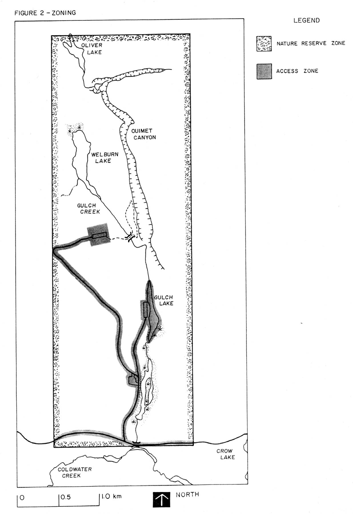
Figure 3 - Existing development
Enlarge figure 3 - Existing development map
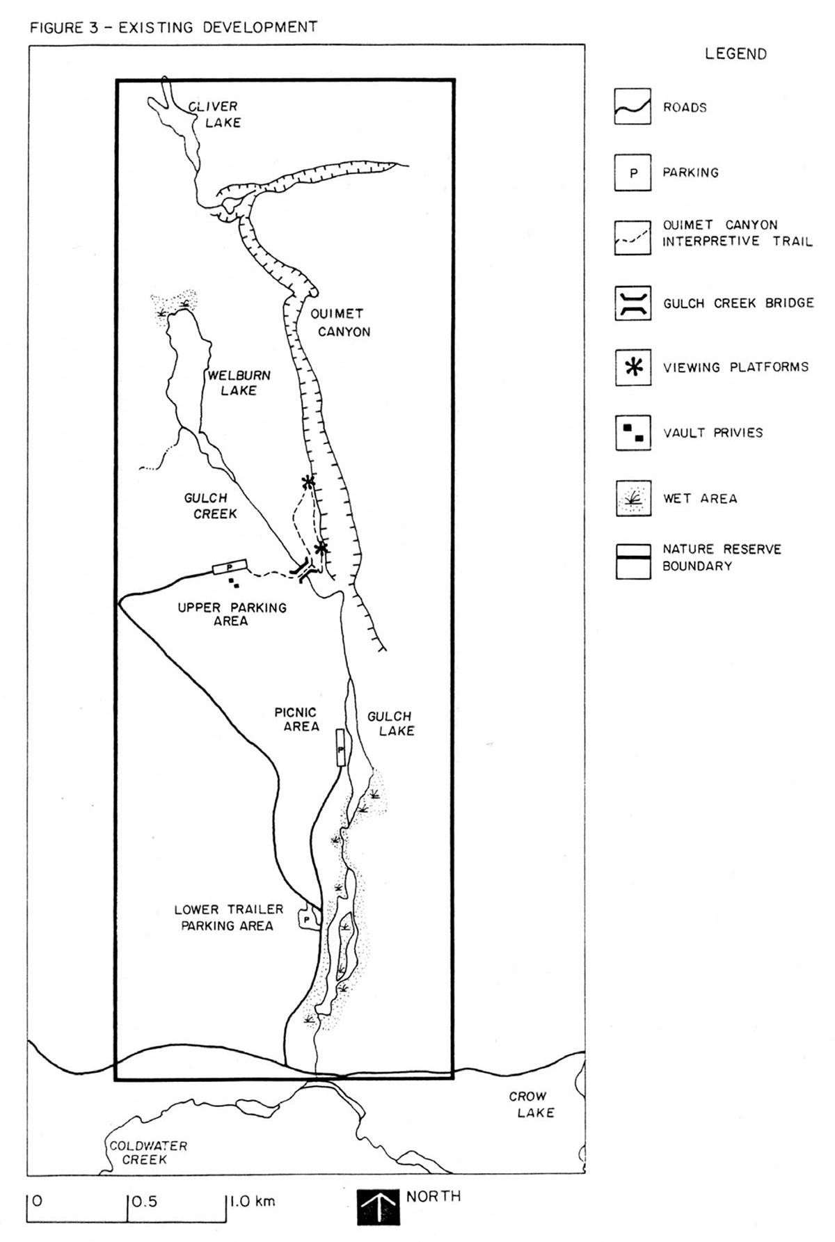
Figure 4 - Existing/proposed development - Canyon Viewing Area
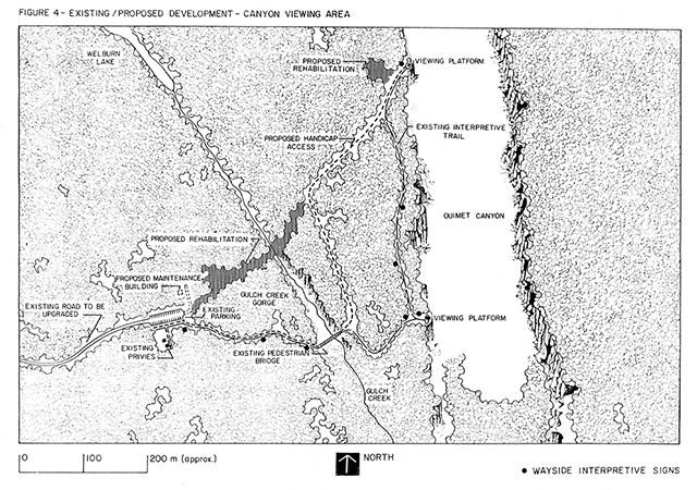
Enlarge figure 4 - Existing/proposed development - Canyon Viewing Area
4.1.3 Outdoor education
Outdoor education will be limited to groups with a specific interest in the earth or life science features of the park. Group activities must be compatible with park objectives. The groups will receive park orientation through contact with the District Office, park staff (from Sibley Park) and park literature.
4.2 Research
Scientific research by qualified individuals will be encouraged, if consistent with park objectives. All research programmes will require the approval of the Ministry of Natural Resources and will be subject to ministry policy and applicable provincial and federal legislation.
Researchers seeking approval to collect plant specimens will first be directed to major herbaria, which already contain voucher specimens.
A detailed study of the arctic-alpine flora and the microclimate with which it is associated should be encouraged.
4.3 Recreation management
Activities appropriate for Ouimet Canyon Provincial Nature Reserve include quiet pastimes such as scenic viewing, nature study, photography, art, snowshoeing and cross-country skiing.
Since access will be discouraged in certain areas of the park (section 3.1), activities requiring large areas such as orienteering or hiking, will be encouraged at other nearby provincial parks.
Rock climbing is not considered compatible with park objectives and will not be permitted. The canyon rim is considered unsafe and, access to the canyon floor is restricted due to the occurrence of rare plant species (section 3.2).
Other non-compatible activities in the park include: sport hunting, snowmobiling, all-terrain vehicles (all forms), horseback riding, camping, and organized team sports.
4.4 Marketing
Ouimet Canyon Provincial Nature Reserve will continue to be marketed as a significant viewing experience in northwestern Ontario. The canyon view is a key tourist attraction for the area and therefore generates considerable economic benefit. The park is a 'must see' attraction, and, a valuable part of the 'Stay an Extra Day' marketing concept for the area.
The existing marketing plan will be updated as required. An approach to encourage 'word of mouth' promotion, not only by staff in nearby parks, but by staff in other parks along the Trans-Canada Highway, will be a component of the revised plan.
4.5 Fee collection
The desirability of instituting fee collection has been reviewed and has been rejected. No fees will be collected.
5.0 Development
Development will proceed in accordance with approved development plans and provincial park development standards. In all instances approved detailed site plans which will be available for public review will precede all development. The requirements of the Environmental Assessment Act will be adhered to. Existing and proposed development are shown on Figures 3 and 4 respectively.
5.1 Vehicular circulation and parking
An evaluation of the road network within the park will be undertaken to determine general suitability for present and projected traffic. Design criteria will be established and applied to ensure that minimum road standards are achieved as close as possible to secondary road standards of the Ministry of Transportation and Communications.
The development of the upper parking lot at the head of the interpretive pedestrian trail will follow the existing site plan. All other parking areas will be evaluated in terms of their present and projected use. Improvements will be made where necessary to ensure that adequate and properly designed parking facilities are incorporated into the overall circulation planning.
Facility areas not deemed necessary to adequately service public need may be closed and rehabilitated (i.e. the lower trailer parking lot, and the Gulch Lake day use area).
5.2 Landscaping
As an immediate priority, all construction scars resulting from recent development activity will be rehabilitated according to the approved "Planting and Rehabilitation Plan" (Map 4).
Due to the concentrated nature of use in the parking and trail area, landscaping and rehabilitation will be monitored regularly, and improvements will be made on an ongoing basis.
5.3 Signage
Signage along the township road and within the park will be improved according to the existing "Sign Plan". The proposed park entry sign will be installed as soon as funds permit. Priority will be given to installing all necessary signs at the earliest time possible.
5.4 Ouimet Canyon interpretive trail
The return segment of the interpretive loop trail (between the northerly viewing platform and the Gulch Creek Bridge) will be developed according to the existing site plan. All pedestrian trail work will be completed as soon as feasible, according to approved site plans.
5.5 Facilities for the handicapped
Access for the handicapped and less capable visitors will continue to be a consideration of the approved development plan.
Wayside rest stops with benches have been designated along the trail and wheelchair ramp structures will be installed where necessary, as funds permit.
5.6 Work area
To reduce the need of transporting supplies and equipment to and from the park on a daily basis, a suitable location will be identified for a small vandal-resistant maintenance and storage building.
6.0 Plan implementation
The management plan will be reviewed not less than every 10 years following its approval or as the need arises. Data collection and environmental monitoring will be conducted regularly. This will include monitoring the impact of visitors on the park’s natural features and monitoring rock stability along the cliff edge.
Below is a list of priority projects to be undertaken as funding permits.
- Update of marketing plan
- Evaluation of vehicular circulation and parking
- Implementation of sign plan (including entry sign)
- Development of the return segment of the Ouimet Canyon Interpretive Trail
- Location and construction of wayside rest stops according to design standards and development plan
- Construction of wheelchair ramps
- Construction of equipment building
- Ongoing rehabilitation and landscaping work according to planting and rehabilitation plan
7.0 Public consultation
The preliminary Management Plan for Ouimet Canyon Provincial Nature Reserve was available for review to the general public, the academic community, special interest groups and others between February 6, 1985 and March 8, 1985. No major concerns or suggested revisions were identified during this review period.
References
Hills, G.A., 1959. A Ready Reference to the Description of the Land of Ontario and its Productivity. Preliminary report, Ontario Department of Lands and Forests, Toronto.
Ontario Ministry of Natural Resources. 1975. Ouimet Canyon Provincial Park Master Plan. Toronto.
Ontario Ministry of Natural Resources. 1978a. Ontario Provincial Parks Policy. Toronto.
Ontario Ministry of Natural Resources. 1978b. Ontario Provincial Parks Planning and Management Policies. Toronto.