Pan Lake Fen Provincial Park Management Statement
This document provides policy direction for the protection, development and management of Pan Lake Fen Provincial Park and its resources.
Interim Management Statement
2006
Approval statement
I am pleased to approve this Interim Management Statement for Pan Lake Fen Provincial Park. Ontario’s Living Legacy Land Use Strategy (1999) identified this area as a nature reserve class provincial park. Pan Lake Fen Provincial Park was regulated under the Provincial Parks Act in October 2000 (O. Reg. 685/00).
This Interim Management Statement provides direction for the protection and custodial management of Pan Lake Fen Provincial Park.
Original signed by:
Paul Bewick
Zone Manager
Northeast Zone
Ontario Parks
Date: May 24, 2006
1.0 Introduction
Pan Lake Fen Provincial Park lies approximately 40 kilometres northeast of the town of Marathon, 40 kilometres south of Manitouwadge and west of Highway 614 (Figure 1). This 496-hectare nature reserve class park is regulated under the Provincial Parks Act (O. Reg. 685/00) (Figure 2).
This nature reserve class park protects distinct natural habitats and landforms within this region of Ontario. The park may provide opportunities for education and research, which will benefit both present and future generations.
1.1 Objectives
Pan Lake Fen Provincial Park will be managed consistent with the two main objectives for nature reserve class provincial parks:
Protection: To protect provincially significant elements of the natural and cultural landscapes of Ontario.
Heritage Appreciation: To provide opportunities for exploration and appreciation of the outdoor natural and cultural heritage of Ontario.
2.0 Management context
This Interim Management Statement (IMS) provides direction for custodial management of park resources. The direction for resource stewardship, permitted uses, development and operations may be reviewed during future management planning as required.
Park management will follow direction from:
- Provincial Parks Act (1990) and regulations
- Ontario’s Living Legacy Land Use Strategy (OMNR 1999), policy amendments (OMNR 2000) and related direction
- Ontario Provincial Parks Planning and Management Policies (OMNR 1992) and updates
- Ontario Crown Land Use Policy Atlas (OMNR 2004a)
In addressing custodial management obligations to protect park values and ensure public health and safety, Ontario Parks will ensure that policy and environmental assessment requirements are implemented.
The park superintendent will implement the policies, procedures and legislation that are derived from the above direction and written into this IMS.
2.1 Environmental Assessment
As part of the Ontario Ministry of Natural Resources (MNR), Ontario Parks is a public sector agency which is subject to the Environmental Assessment Act (1990). Park management will be carried out in accordance with legislation, policies and MNR's A Class Environmental Assessment for Provincial Parks and Conservation Reserves (OMNR 2005a).
3.0 Park features and values
The park is a representative natural heritage area within the southern Boreal forest. The site is a large wetland that has formed in the headwaters of Namebin Creek, which in turn drains south into the Black River and Lake Superior (Kershaw 2002).
3.1 Geological features
Bedrock knolls and ridges of moderate relief occur along the west side of the site and define the west bank of Namebin Creek. Some of the bedrock is well exposed in cliffs and steep slopes, especially in the northwest corner of the site. The bedrock of the site lies within the Wawa Subprovince of the Superior Structural Province, part of the Precambrian Shield. The bedrock is overlain by a thin, discontinuous veneer of stony and sandy till (Kor 2003).
The majority of the park consists of wetland vegetation and muck on a broad plain surrounding Namebin Creek. The substrate of this wetland complex is likely clay and silt, possibly related to the glacial Lake Minong, which once occupied the area. Dendritic drainage rills and several indistinct, possible beach forms on adjacent dry plains suggest that glaciolacustrine sedimentation, and possibly glaciofluvial accumulation, may ave occurred in the quiet waters of this arm of Lake Minong, and are represented by the lowland areas of this site (Kor).
Figure 1: Regional Setting
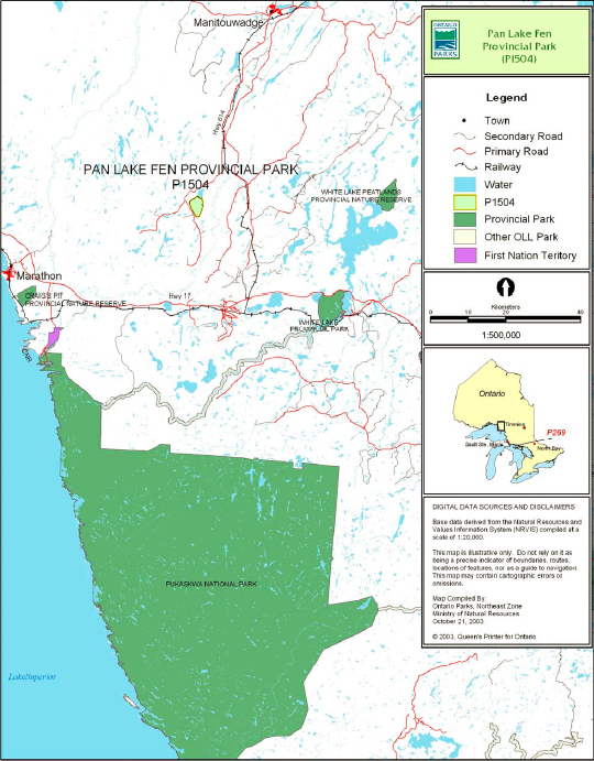
Figure 2: Park Boundary
3.2 Biological features
Pan Lake Fen occurs on an organic deposit and is surrounded by moderately broken fluvial deposits.
The main biological features of this nature reserve include a coniferous swamp near Pan Lake, tall shrub thickets, graminoid fen with some areas dominated by low shrubs, and areas that are transitional between these vegetation types (Morris 2001).
Located in Ecodistrict 3E-4, the park protects a headwater wetland complex of Namebin Creek, a tributary of the Black River.
3.3 Cultural setting
No detailed survey or analysis of the cultural history and features of the park have been conducted to date.
Future planning for cultural heritage will be done within the context of the provincial framework, A Topical Organization of Ontario History (OMNR 1974). Planning will also involve updates and discussions with other agencies, First Nation communities and interest groups to identify cultural heritage values and features, and their significance, within the park. This information may be used to develop management guidelines to conserve and protect representative archaeological or historical values and features, and to provide direction for further research.
3.4 Recreation
The maintenance of environmental quality and the protection of park values are fundamental to the management of Pan Lake Fen Provincial Park. Nature reserve policies will ensure that natural processes are allowed to function freely, within the constraints of public safety and the need to protect values within and adjacent to the nature reserve.
Pan Lake Fen Provincial Park receives little recreational use. There are no known existing recreational trails or campsites in the area (Kershaw).
Nature study and exploration of the park’s fen system are potential activities, however more diverse and accessible fens are found elsewhere in the ecodistrict.
Namebin Creek is ingrown with shrub thickets and fen vegetation for the first kilometre below Pan Lake. Approximately four kilometres of the creek within the park is navigable by canoe (Kershaw).
4.0 Aboriginal rights
Pan Lake Fen Provincial Park is located within the Robinson Superior Treaty (1850) and lies just north of Highway 17 between the Ojibways of the Pic River and Pic Mobert Indian reserves.
During the boundary regulation process, consultation with Ojibways of the Pic River and the Pic Mobert First Nations was completed. There were no comments received regarding regulation of the park.
First Nations have expressed interest in and have shared knowledge of the park and surrounding area. Aboriginal communities have used the area for hunting, trapping, fishing, gathering and travel. These uses may continue, subject to public safety, conservation and other considerations.
Any communications and cooperation between Aboriginal communities and the MNR for planning and operations purposes will be done without prejudice to any future discussions or negotiations between the government of Ontario and Aboriginal communities.
5.0 Stewardship policies
5.1 Terrestrial ecosystems
The removal, damage or defacing of Crown property, natural objects, relics and artifacts is not permitted in provincial parks (Provincial Parks Act).
5.1.1 Vegetation
Harvesting
Commercial forest harvesting and renewal activities are not permitted within the boundaries of this nature reserve provincial park (OMNR 1992; 2004a).
There are no fuel wood cutting permits currently issued within the boundaries of Pan Lake Fen Provincial Park. No new permits will be issued (OMNR 2000).
The commercial harvest of non-timber forest products (e.g. wild rice, club moss, Canada yew) will not be permitted within the boundary of Pan Lake Fen Provincial Park (OMNR 1992; 2004a).
Non-native plants
Non-native plant species will not be deliberately introduced into the park. Where non-native plant species are already established, and threaten park values, a strategy may be developed to control the species (OMNR 1992).
Insects and disease
Insects and diseases may be managed where the aesthetic, cultural, or natural values of the park are threatened (OMNR 1992).
Control methods will follow guidelines established by the Ontario Ministry of the Environment (MOE) and the MNR. Biological controls, in preference to chemicals, will be used whenever possible (OMNR 1992).
Fire
Pan Lake Fen Provincial Park is located within the Boreal Fire Management Zone. In accordance with existing provincial park policy and the Forest Fire Management Strategy for Ontario, forest fire protection will be carried out in Pan Lake Fen Provincial Park as on surrounding lands.
Whenever feasible, MNR's Forest Fire Management program will use techniques which minimize damage to the landscape such as limiting the use of heavy equipment or limiting the number of trees felled during response efforts (OMNR 2004b).
5.1.2 Wildlife management
Pan Lake Fen Provincial Park is located in Wildlife Management Unit (WMU) 21b. Removal or harassment of non-game animals is not permitted in provincial parks (Provincial Parks Act).
Hunting
Hunting is not permitted within this nature reserve park (OMNR 1992; 2003; 2004a; 2005b).
Bear Management Areas
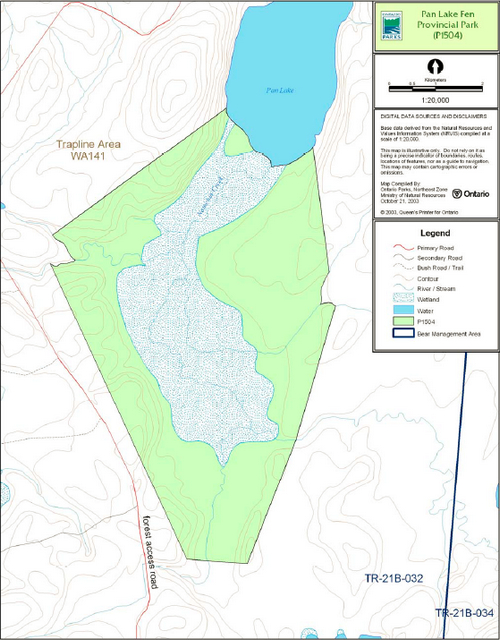
Prior to park regulation, a portion of one un-licensed (TR-21B-032) bear management area (BMA) was within the boundary of this park (Figure 2). The portion of this BMA that is within the regulated park boundary will be withdrawn from the legal description of the license.
This use is not permitted in nature reserve parks (OMNR 1992; 1999; 2003; 2004a).
Trapping
A portion of trap line area WA-141is located within the park (Figure 2). This trap line is not currently under active license. The portion of this inactive license which is located within the park will be withdrawn from the legal description of the trap line (OMNR 2000). No new operations, including trap line cabins and trails, will be permitted in the park (OMNR 2000; 2004a).
5.1.3 Industrial resources
Commercial mineral exploration and extraction, sand and gravel extraction and peat development are not permitted within the park (OMNR 1992; 2004a).
The land included in Pan Lake Fen Provincial Park has been withdrawn from mining activity under the Mining Act.
5.1.4 Access and crossings
Access
Access to Pan Lake Fen Provincial Park occurs from an adjacent forest access road.
Roads
The logging road leads to the west side of the park but does not provide direct access into the park. There are no roads or authorized trails within the site. There are no crossings or proposed forest access roads in the park.
New roads will not be permitted in the park (OMNR 2004a).
Utility corridors
There are no utility corridors within the boundary of the park. All public utilities (e.g. gas pipelines, transmission lines, communications towers, etc.) must avoid park lands wherever possible (OMNR 2004a).
Any future utility corridors proposed through the park, where park lands are unavoidable, will be reviewed on a case-by-case basis. Protection of park values will be a priority and the requirements of the Environmental Assessment Act must be met.
Recreational trails
There are currently no authorized trails within the park boundary. If there is a perceived need, new trails (e.g. hiking) may be proposed during park management planning, with public consultation. Any proposed development within the park is subject to MNR's environmental assessment requirements.
5.1.5 Adjacent land management
The lands adjacent to Pan Lake Fen Provincial Park are within the Black River Forest Management Unit. This forest is currently managed by Great West Timber Limited.
An existing road to the west of the park is used for forest management purposes.
General Use Area
The Interior General Use Area (G2688) is a 864,125 hectare area which surrounds the Pan Lake Fen Provincial Park. The primary intent of the area is to provide for resource extraction activities. Cottaging, general Crown land recreation and outpost camp tourism continue to be of importance. Additional cottage development will generally take priority over additional outpost camp proposals.
5.1.6 Land disposition
There are no existing private recreational camps, cottage lots, land use permits (LUP), or licenses of occupation within the park.
No new land disposition for the private use of individuals or corporations will be permitted.
Boat caches
There are no authorized boat caches within this provincial park. As stated in the Provincial Parks Act, boats are not permitted to be left unattended in the park without written permission from the park superintendent.
5.2 Aquatic ecosystems
Sustaining quality water resources is fundamental to the protection of park and adjacent land values. The MOE enforces applicable legislation and regulations pertaining to water quality.
5.2.1 Water management
There are no dams, water control structures, or diversions within the park. Hydroelectric development is not permitted within the park (OMNR 1992).
New water control structures may only be considered for the perpetuation of natural features and conditions, subject to management planning (OMNR 2002).
5.2.2 Fisheries management
Pan Lake is a cool shallow lake adjacent to the site. A small stream, Namebin Creek, drains from Pan Lake through the park.
Fisheries management activities will be aimed, wherever possible, at the maintenance and enhancement of native, self-sustaining fish populations (OMNR 1992).
Sport fishing
Sport fishing is permitted within Pan Lake Fen Provincial Park. Any sport fishing activity is governed by the legislation and regulations in the Fish and Wildlife Conservation Act (1997), as well as the federal Fisheries Act (1985). The Recreational Fishing Regulations Summary (2005c) contains more information regarding general regulations and exceptions to these regulations for the area of this park.
Commercial fishing
There are no commercial fishing operations within Pan Lake Fen Provincial Park. No new operations will be permitted (OMNR 1992; 2004a).
Commercial baitfish harvesting
There are currently no active bait fish harvesting licenses within this park. Bait fishing is not a permitted activity in this class of park. New operations will not be permitted (OMNR 1999).
6.0 Operations policies
6.1 Recreation management
Future management planning, with public consultation, will review the current direction on motorized and non-motorized recreation uses.
6.1.1 Motorized recreation
Motorboats
Motorized watercrafts are not permitted on the waters contained within the boundary of this provincial park (OMNR 1992; 2004a).
Aircraft
Aircraft landings are not permitted within this nature reserve park (OMNR 2004a).
Snowmobiles
There are currently no authorized snowmobile trails within the park boundary. Off-road use of snowmobiles is prohibited. New trail development will not be permitted within this park.
All-terrain vehicles
There are currently no authorized all-terrain vehicle (ATV) trails located within the park.
Off-road use of ATVs is prohibited. New trail development will not be permitted within the park.
6.1.2 Non-motorized recreation
Camping
Overnight camping and the development of campground or campsite facilities are not compatible with nature reserve policies (OMNR 1992; 2004a).
Hiking
There are no authorized hiking trails within the boundaries of this provincial park. If there is an identified need, new hiking trail development may be considered (OMNR 2004a). Hiking trail development is subject to park management planning and the requirements of the Environmental Assessment Act.
6.1.3 Emerging recreational uses
There are emerging recreational uses for which there is limited or no policy to deal with their management (e.g. adventure racing, geocaching, etc.). The park superintendent will use legislation, policy and guidelines that are in place in the interim to manage emerging uses.
6.2 Development
There is no existing development within the boundaries of this provincial park. New development within the park will only be considered through future park management planning.
Any proposed development within the park is subject to the requirements of the Environmental Assessment Act.
6.3 Commercial tourism
Infrastructure for commercial tourism does not exist within this provincial park.
Commercial tourism is not compatible with the nature reserve classification of this park (OMNR 1992). No new commercial tourism dispositions (e.g. commercial LUPs) will be issued within Pan Lake Fen Provincial Park (OMNR 2004a).
7.0 Cultural resources
An assessment of the cultural resources of Pan Lake Fen Provincial Park has not been completed at this time. Management of any cultural features and values within this park will be directed toward protection and heritage appreciation (OMNR 1992).
8.0 Heritage education
Literature and other supporting information may be developed to describe the park in the context of Ontario’s provincial park system. Boundary limits, significant heritage features and permitted uses of the waterway park may be included in park literature.
Prospective park visitors may be informed about the sensitivity and significance of park values through park literature.
9.0 Research
Scientific research by qualified individuals which contributes to the knowledge of natural or cultural history, or to environmental or recreational management, may be encouraged in the park. Ontario Parks will encourage institutions, such as universities, to undertake research projects.
All research programs will require the approval of Ontario Parks and are subject to park policy and other applicable legislation. Any materials removed from the park will remain the property of Ontario Parks.
Approved research activities and facilities will be compatible with the park’s protection objective. Any site which is affected by research will be rehabilitated as closely as possible to its original state. Environmental Assessment Act requirements will apply.
10.0 References
Environmental Assessment Act, 1990.
Fisheries Act, 1985.
Fish and Wildlife Conservation Act, 1997.
Kershaw, W., 2002. Pan Lake Fen Provincial Park Recreation Inventory Report - Version 1.5. Ontario Ministry of Natural Resources.
Kor, P., 2003. Earth Science Inventory Checklist - Pan Lake Fen Provincial Nature Reserve. Ontario Ministry of Natural Resources.
Morris, E., 2001. Natural Heritage Area Life Science Checksheet – Pan Lake Fen Provincial Park (P1504). Ontario Ministry of Natural Resources.
Ontario Ministry of Natural Resources, 1974. A Topical Organization of Ontario History. Historic Sites Branch Division of Parks.
Ontario Ministry of Natural Resources, 1992. Ontario Provincial Parks Planning and Manaement Policies.
Ontario Ministry of Natural Resources, 1999. Ontario’s Living Legacy Land Use Strategy.
Ontario Ministry of Natural Resources, 2000. Ontario Provincial Park Policy as Amended by the Ontario Living Legacy Land Use Strategy.
Ontario Ministry of Natural Resources, 2003. Directions for Commercial Resource Use Activities in Provincial Parks and Conservation Reserves. 5 pp.
Ontario Ministry of Natural Resources, 2004a. Crown Land Use Policy Atlas.
Ontario Ministry of Natural Resources. 2004b. Forest Fire Management Strategy for Ontario. Aviation and Fire Management Branch.
Ontario Ministry of Natural Resources, 2005a. A Class Environmental Assessment for Provincial Parks and Conservation Reserves.
Ontario Ministry of Natural Resources. 2005b, Hunting Regulations Summary.
Ontario Ministry of Natural Resources. 2005c, Recreational Fishing Regulations Summary.
Provincial Parks Act, 1990.
Appendix A: Background information
| Name | Pan Lake Fen Provincial Park (P1504) |
|---|---|
| Classification | Nature Reserve |
| Ecoregion/Ecodistrict | 3E-4 (Tip Top Mountain) |
| OMNR Administrative Region/District | Northeast Zone, Wawa District |
| Total area (ha) | 496 |
| Regulation date & Number | October 2000 (O. Reg. 685/00) |
Representation
Earth science:
Bedrock knolls and ridges of moderate relief occur along the west side of the site. The bedrock consists of an undifferentiated suite of intrusive rocks that lie within the Wawa Subprovince of the Superior Structural Province, Canadian Precambrian Shield. Most of Pan Lake Fen Provincial Park consists of wetland vegetation and muck on a broad plain of sand, silt and clay surrounding Namebin Creek (Kor 2003).
Life science:
Pan Lake Fen Provincial Park is situated in the north of Ecodistrict 3E-4 and encompasses 20 different landform vegetation combinations (Morris 2001).
The park exists on an organic deposit surrounded by moderately broken fluvial deposits and protects a headwater wetland at the outflow of Pan Lake on Namebin Creek.
Cultural resources:
There has been no examination or documentation of cultural values that may exist within Pan Lake Fen Provincial Park.
Recreation & tourism:
This park is a nature reserve class which protects representative natural areas within the southern Boreal forest. Potential recreational activities of this park include nature study, exploring and canoeing (Kershaw 2002).
Namebin Creek runs north to south within the site and is navigable through the wetland. The creek eventually joins with the Black River which flows into Lake Superior.
Inventories
| Survey Level | Earth Science | Life Science | Cultural | Recreational |
|---|---|---|---|---|
| Reconnaissance | Kor, 2003 | Morris, 2001 | Kershaw, 2002 |