Pipestone River Provincial Park Management Plan
This document provides policy direction for the protection, development and management of Pipestone River Provincial Park and its resources.
Amendment approval statement (2019)
May 7, 2019
Dear Sir or Madam:
I am pleased to approve this amendment to the 2002 management plan for Pipestone River Provincial Park. The amendment provides revised direction in the management plan for the issuance of commercial tenure and conditions of any disposition, including requirements under the Provincial Parks and Conservation Reserves Act and approval through an environmental assessment process.
I would like to express my appreciation to those who participated in the planning process.
Sincerely,
Jason Travers, A/Director
Ontario Parks
Approval statement (2002)
I am pleased to approve this park management plan as the official policy for the protection and management of Pipestone River Provincial Park. The plan reflects the Ministry of Natural Resources' and Ontario Parks' intent to protect the park’s natural and cultural features; to develop and maintain a range of high quality opportunities for outdoor recreation and heritage appreciation for Ontario residents and visitors; and, to contribute to the economic well-being of surrounding communities.
This plan provides unique potential for area First Nations, communities, the resource based tourism sector and others to work in partnership with Ontario Parks to achieve its goal and objectives. It includes a prioritized implementation strategy and summarizes the public consultation that helped shape the plan.
Plan amendments may be initiated to consider future resource-based tourism proposals complementary to the parks goal and objectives. Additionally; new resource information, changing conditions or developing issues may suggest the need for a broader plan review.
I wish to extend my sincere thanks to all those who participated in this important process.
Signed by:
Adair Ireland-Smith
Managing Director
Ontario Parks
Statement of Environmental Values and the Environmental Bill of Rights
In accordance with the provisions of the Environmental Bill of Rights, the Ministry of Natural Resources prepared a Statement of Environmental Values. It describes how the purposes of the Environmental Bill of Rights are to be considered whenever decisions are made which might significantly affect the environment. This includes decisions made as a result of park management planning.
The primary purpose of the Environmental Bill of Rights is "to protect, conserve, and wherever reasonable, restore the integrity of the environment." From the Ministry’s perspective, the broad statement of purpose translates into four objectives in its Statement of Environmental Values:
- to ensure the long-term health of ecosystems by protecting and conserving our valuable soil, aquatic resources, forest and wildlife resources as well as their biological foundations
- to ensure the continuing availability of natural resources for the long-term benefit of the people of Ontario
- to protect natural heritage and biological features of provincial significance
- to protect human life, the resource base and the physical property from the threats of forest fires, floods and erosion
The Ministry’s Statement of Environmental Values is being considered in the development of a park management plan for Pipestone River Provincial Park.
1.0 Introduction
Pipestone River Provincial Park is located north and northwest of the town of Pickle Lake and overlays the traditional territories of Mishkeekogamang, Slate Falls, Cat Lake, North Caribou Lake, Kingfisher and Wunnumin Lake First Nations.
Established January 3rd, 1989 the protected portion of the waterway is approximately 315 kilometres in length. Significant glacial features include a fluted ground moraine, DeGeer moraines, Big Beaverhouse moraine and Glacial Lake Agassiz sands and silts.
Pipestone River Provincial Park provides excellent opportunities for backcountry canoeing and camping to visitors with wilderness and white-water skills. The park is important to the resource-based tourism industry of the area and contains a number of fly-in outpost cabins and a seasonal outpost camp. In the absence of a park fee structure, non-residents of Canada are subject to the conditions of the Crown land camping program (including Crown land camping fees).
An approved park management plan for Pipestone River Provincial Park will provide:
- a definition of the role, significance and classification of the park within the provincial park system
- a statement of policy for the protection, planning, development and management of the resources and attributes of the park
- assurance that the planning, management and development of the park is compatible with the protection of the environment and is responsive to the public interest
- guidance for the preparation of subsequent resource management plans or amendments required to implement park policies and achieve program objectives
- a rationale and priorities for implementation activities
- a record of public consultation and input into the planning process
- a basis for the ongoing monitoring of the development and management of the park
The preparation of the plan for Pipestone River Provincial Park has aimed to address three key areas:
-
Fulfillment of the Pipestone River Provincial Park Role within the Park System:
Pipestone River Provincial Park is a spectacular waterway park in a remote setting that offers the visitor the pristine experience of a secluded northern waterway, the challenge of exciting whitewater and the visual drama of ancient forces that continue to shape the landscape today. This plan recognizes the importance of protecting the Pipestone environment and its experience for the people of Ontario as part of the Ontario Parks system.
-
Aboriginal Rights of Access and Use:
The traditional lands of at least six First Nations overlay Pipestone River Provincial Park. Traditional activities on the land continue to be a central part of today’s lifestyle for residents of all of these First Nations. The management and development policies of this plan are without prejudice to any existing Aboriginal or Treaty rights engaged in by First Nation’s peoples with Treaty rights for this area.
This plan further recognizes that First Nations:
- remain welcome to continue the range of activities that are protected by Aboriginal and Treaty
- need to be continuous participants in the planning and management of activities that may involve or affect their traditional
- must share in economic benefits generated from park
-
Contribution to the Regional Economy:
The plan recognizes the important contribution that resource-based tourism makes to the regional economy. Much of the area around Pipestone River Provincial Park can be considered remote. Economic opportunity for area communities is generally limited and often dependent upon resource-based tourism. An increased focus on resource-based tourism is a major benefit of this plan. Park and area waters offer a particular experience that can only be found in remote Northern Ontario.
The Pipestone River Management Plan approves a tourism proposal for Kinloch Lake and establishes a framework for guiding resource-based tourism activity into the future. Future proposals can be considered that respect limitations created by the existing level of tourism development and resource activity already in place at the time of plan approval.
This park management plan can be viewed as a commitment by the Ministry of Natural Resources and Ontario Parks to work effectively with area partners in protecting and managing Pipestone River Provincial Park for the benefit of the park, its visitors and local communities.
For quick reference a summary table of the permitted uses and guidelines presented in this management plan is contained in Appendix 1.
2.0 Summary of significant issues
This section represents a summary of significant issues that were raised during the management planning process.
2.1 Delays in management planning
Nishnawbe Aski Nation (NAN) communities have longstanding concerns regarding the potential negative impacts of establishing provincial parks on lands where First Nations may have economic development interests. In the mid-1980's several new waterway parks were established within NAN's traditional lands. NAN and its member communities continue to express concerns ranging from general interference with the exercise of constitutionally protected rights to the inability to develop economic ventures such as commercial tourist camps and associated activities.
Ontario’s approach to Aboriginal affairs is contained within the Aboriginal Policy Framework. The framework is intended to ensure that provincial policies, programs and services directed to Aboriginal people help create opportunities for employment and economic development, which will strengthen the self-reliance of Aboriginal communities. It is acknowledged that extended delays in park management planning can hold up Aboriginal business opportunities that require new developments.
Consistent with the Aboriginal Policy Framework an important aspect of this management plan identifies and builds upon business opportunities and stewardship relationships for First Nation and other stakeholder interests that may benefit from the management and operation of Pipestone River Provincial Park. Additionally, this management plan provides:
- an opportunity for a minor land disposition based upon a resource-based tourism proposal from a member of the Cat Lake First Nation. Upon approval of the final park management plan a land use permit may be issued to authorize the future development of a commercial outpost camp in Zone NE 1
Opportunities elsewhere in the park may be considered through future plan amendments that are subject to criteria identified in this plan.
2.2 Scope of management plan
This document establishes policy direction for Pipestone River Provincial Park that is consistent with goals and objectives of the Ontario Provincial Parks system. It should be noted, however, that this management plan has proceeded without the full range of inventory information that would normally form the basis for policies in a management plan. Consequently this management plan does not provide the level of detail for the entire park that might be expected in a park management plan. Rather, it establishes a broad range of policy direction for the entire park based on park classification and the current range of uses. Specific approval is provided regarding a resource-based tourism development on Kinloch Lake. This authorization is based upon resource calculations intended to ensure that any new development remains consistent with the fisheries capacity of the river and on-site inspections to ensure that the development proposal will not conflict with any unique or significant park features. Future amendments that may consider additional or new uses will also need to identify and address any information shortfalls that may exist.
This approach to park management planning in Pipestone River Provincial Park recognizes the need to address resource-based tourism potential in a timely fashion. It further recognizes that the evolving nature of land use planning in the north requires management plan policies that will respond appropriately to issues of the park, area First Nations, communities, the resource-based tourism industry and other stakeholders.
2.3 Ongoing Aboriginal relationships
The entire land base of Pipestone River Provincial Park overlaps territory traditionally relied upon by members of nearby Aboriginal communities.
Throughout the planning process strong concerns were expressed regarding the creation of the park and its potential to impact Aboriginal rights and uses. Considerable efforts have been directed towards attempting to respond positively to the concerns that were expressed and to respect the advice that was given. A general listing of these concerns can be found in section 13.1: Aboriginal Involvement. How they have been addressed is found throughout the planning document. Some of the matters that were raised are beyond the scope of this management planning effort. These have also been recorded in section 13.1: Aboriginal Involvement and will need to be resolved through alternative means at another time.
A frequent point, spoken in a number of ways, expressed a need for the plan to be relevant into future decades. It was emphasized that Aboriginal people must always feel comfortable on park lands. Unborn children who will never know a time when there was not a park, must feel at home as they exercise their rights – whether on, or off, park lands. Through an ongoing recognition of Aboriginal uses, the protection of Aboriginal values, Aboriginal participation in park management activities and the education of park visitors this plan attempts to provide the basis for a relationship that will work to achieve this end.
2.4 First Nation land use plans
Both the Windigo and Shibogama Interim Planning Boards have produced land use plans for their respective traditional areas. The plans are advice to the Ontario Government reflecting First Nation views on land use, development and decision making in their traditional areas. The park boundary overlaps the planning areas covered by these two documents.
Subsequent to this management planning process, efforts will be made with both the Windigo and Shibogama Tribal Councils to identify and address common elements for the mutual benefit of all parties.
3.0 Park classification
Pipestone River Provincial Park is classed as a waterway park, one of six classes of parks in the Ontario Provincial Parks system.
Waterway parks incorporate outstanding recreational water routes with representative natural features and historical resources that support high quality recreational and educational experiences. They offer to their users a chance to experience the power and continuity of Ontario’s great waterways, and to appreciate the central place of those waterways in the natural and cultural heritage of the province.
Pipestone River Provincial Park classification acknowledges the representative natural features of ecoregions 2W and 3S as well as outstanding recreational opportunities offered throughout its approximate 315 kilometre length, extensive whitewater sections (37 sets of rapids ranging from Class 1 to 5+) and scenic setting.
4.0 Goal
The goal of Pipestone River Provincial Park is:
- To protect the significant natural and cultural features of Pipestone River Provincial Park and to provide opportunities for recreational uses that are compatible with the area’s remote nature
This goal recognizes:
- the representative contribution that Pipestone River Provincial Park makes to the Ontario Parks System
- that the remote nature of the park contributes to the high quality of its recreational environment
- that the park landscape is, and will continue to be, an important component of the traditional lands and land uses of Mishkeekogamang, Slate Falls, Cat Lake, North Caribou Lake, Kingfisher and Wunnumin Lake First Nations
- the importance of resource-based tourism to the area and the contribution that the park can make to regional development goals for the benefit of area residents
5.0 Objectives
The Ontario Provincial Parks system has four objectives: protection, recreation, heritage appreciation and tourism. As a waterway park, Pipestone River Provincial Park will contribute to all four of these objectives:
5.1 Protection
- To protect provincially significant elements of the Park’s natural landscape and cultural features
Pipestone Provincial Park spans ecoregions 2W and 3S. The park was primarily established to fulfill the waterway class target for ecodistrict 2W-3 and 3S-4 although it also captures small sections of 3S-2 and 3S-3. Of particular significance in Pipestone Provincial Park, is the extensive dune system east of the Agutua Moraine, on the south side of the Pipestone River, which resulted in an expansion of the park in this area. The dunes here are nearly all parabolic in shape, oriented by the west wind. Many of the dunes are interconnected to resemble a series of longitudinal transverse dunes. They are largely inactive, vegetated and rise to heights of up to 15 metres. The dunes are unusual, sensitive features and a unique representation of the Aeolian landform.
Other significant features, which contributed to the inclusion of the Pipestone River within the Ontario Provincial Park system, are:
- the presence of a wide variety of bedrock elements from the Uchi, Berens and Sachigo subprovinces
- examples of four major landscape units:
- Lac Seul Moraine – Lac St. Joseph portion
- Agutua Moraine – central portion
- Horseshoe Lake – Wharram Lake bedrock complex
- Big Beaver House Moraine
- significant examples of glacial and lacustrine processes/landforms such as the Agutua Moraine, outwash systems, esker-kame systems, ground moraines, exceptional DeGeer Moraines near Karl Lake and drumlins associated with the area west of Hilyard Lake
A complete cultural resources inventory has not been completed for Pipestone River Provincial Park. First Nations have placed a high priority on the protection of aboriginal cultural sites.
Protection of the parks ecological and cultural integrity is a pre-requisite for achieving the remaining objectives. Additional data from detailed earth, life-science and cultural resources inventories, initiated in 2001, will be a factor in determining the need for any future zoning and management adjustments.
5.2 Recreation
- To provide high quality river recreation, travel and camping opportunities in an outstanding and remote natural setting
This objective recognizes that the remote nature of this waterway is an important element of the park’s high-quality recreational environment. Recreational opportunities include sport fishing and hunting, backcountry canoeing and camping, outpost cabin and day-use experiences. These are supported by both mechanized and non-mechanized means. This objective provides for the continuation of these traditional waterway activities, at levels of use that will maintain the remote nature of the Pipestone experience.
5.3 Tourism
- To provide Ontario’s residents and out-of-province visitors with opportunities to discover and experience a distinctive region of the province and to support the long-term viability of the Pipestone River’s resource-based tourism industry
This objective recognizes the contribution that this remote northern park makes to local economies through resource-based tourism. It provides opportunities for Ontario Parks, area First Nations, communities and stakeholders to work co-operatively in exploring opportunities that will realize additional benefits from the park’s tourism potential. This objective also recognizes that additional resource- based tourism opportunities can be considered but may be limited because of the existing level of tourism development and resource activity already in place at the time of plan approval.
5.4 Heritage appreciation
- To provide opportunities for unstructured individual exploration and appreciation of the natural and cultural heritage of Pipestone River Provincial Park
Although heritage appreciation opportunities will be primarily unstructured, Ontario Parks will encourage park visitors to understand, value and respect all the natural and cultural resources of Pipestone River Provincial Park. Heritage appreciation opportunities will be identified in co-operation with area First Nations, communities and stakeholders.
6.0 Boundary
The area of Pipestone River Provincial Park is approximately 97,375 hectares, most of which is water. The boundary generally encompasses a 200-metre strip on both sides of the park’s 315 kilometres. There are three exceptions where the boundary widens to include:
- an area south and east of Otoonabee Lake and west of Williams La This area was established to provide an ecologically sensible boundary encompassing the height of land between the Morris River and Williams Rivers. From Otoonabee Lake, water flows north and west via the Morris River to the Pipestone River. From Williams Lake, water flows east via the Williams River to the Otoskwin River
- an area northeast of Kinloch Lake which incorporates a number of small but diverse lakes including Coull Lake which drains directly into Kinloch Lake
- an area east of the Pipestone River between the Nord Road and Forester Lake which captures a large dune field east of the Agutua Moraine and is likely the best example of this feature within ecoregion 2W, and ecodistrict 2W-3
The park is not a continuous waterway – the Nord Road (formerly highway 808) breaks it into two separate sections. Not included in the park is a portion of the waterway south of the Nord Road along the Pipestone River to and including Kecheokagan Lake.
On lands adjacent to the park boundary, and within the park watershed, the Ministry of Natural Resources will assure the protection of park values by continuing to provide appropriate input where major developments are proposed and to plans for ongoing resource management activities.
During the development of this management plan a number of issues relating to the park boundary were raised that should be examined in the next plan review. Several of these suggestions include but are not limited to:
- review of the current boundary following completion and analysis of resource inventories
- review of contiguous portions of the waterway that are currently excluded from the park boundary (the Horseshoe Lake area between the North and South sections of the park)
- the renaming of Pipestone River Provincial Park to better reflect the diverse nature of the parks rivers
- the amalgamation of Pipestone River Provincial Park and Otoskwin- Attawapiskat Provincial Park into one
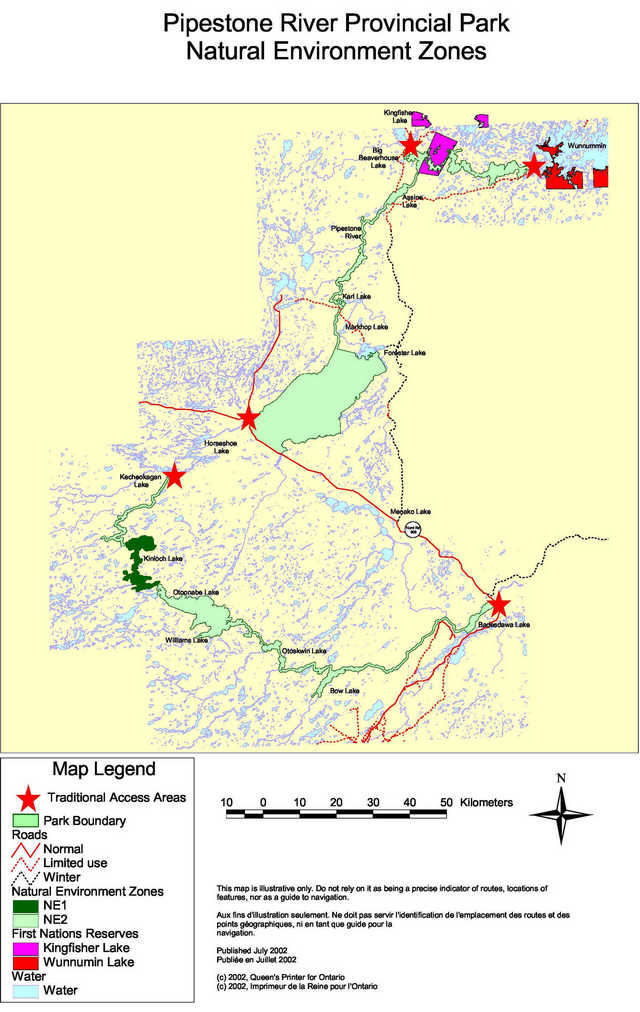
7.0 Zoning
There are six types of zones in the provincial park system: wilderness, nature reserve, natural environment, historical, access and development. Nature reserve and historical zones are established to recognize provincially significant natural and cultural resources which require management distinct from that in adjacent zones.
In Pipestone River Provincial Park there are two natural environment zones that have been identified on the enclosed map. Other zones have not been established at this time. This approach to park zoning is a reflection of the remote nature of the park and the low number of visitors currently using the park. In addition, the complete range of detailed life, earth, cultural or recreational inventories was not available to support the full application of zoning. Therefore, a precautionary approach will be taken when considering any form of resource stewardship, operations or development initiatives. Appropriate resource inventory information will be collected and assessed, and where appropriate, amendments will be made to this plan.
The following section briefly describes the two natural environments zones. All resource and recreational uses and facility development will be subject to legislation and policies governing provincial parks, public lands and resources as well as policies contained within this plan.
7.1 Natural environment zones
Natural environment zones include aesthetic sections of the waterway corridor and associated landscapes in which there is minimum development required to support low intensity recreational activities and water travel.
All of the Pipestone’s water routes are included in the park’s natural environment zones.
Zone NE 1: This zone includes all of Kinloch Lake and an area northeast of Kinloch Lake which incorporates a number of small but diverse lakes that drain directly into Kinloch Lake. It is approximately 6,201 hectares in size. The zone overlays the traditional lands of the Cat Lake First Nation and has been the focus of an Aboriginal development proposal for an outpost cabin. This zone will host the only new development authorized by this management plan. Traditional Aboriginal activities include seasonal occupations and natural resource harvesting (hunting, trapping, gathering and fishing). Recreational activities include backcountry canoe/camping, sport hunting and fishing. Commercial tenure and authorities includes one commercial fishing licence, one commercial boat cache and portions of two traplines. These will continue to be recognized as accepted park activities except as noted below:
- a new eight-bed commercial outpost cabin will be developed on Kinloch Lake
- a commercial fishing licence will be cancelled on Kinloch Lake
Zone NE 2: This zone is approximately 91,174 hectares in size and incorporates the balance of the parks natural features. The zone overlays the traditional lands of a number of First Nations. Traditional Aboriginal activities include seasonal occupations and natural resource harvesting (hunting, fishing, trapping and gathering). Recreational activities include backcountry canoe/camping, outpost cabin and camp experiences, sport hunting and fishing. Commercial tenure and authorities includes land use permits for six outpost cabins and one seasonal outpost camp, one boat cache, three commercial fishing licences, portions of 12 traplines, 10 baitfish blocks and six bear management areas.
One additional land use permit is in place for a private recreational camp. These will continue to be recognized as accepted park activities except as noted below:
- land use permits for private recreational camps will be phased out in accordance with existing provincial park policy
Additional activities not listed above or expansions of existing activities may be considered through a plan amendment process as indicated elsewhere in this plan (8.1.1 Land Disposition; 9.1.1 Tourism Services; 11.0 Implementation Policies; 11.2 Plan Amendment and Review).
7.2 Park access
Although access zones have not been established, traditional areas where park access occurs are located at:
- Wunnumin Lake
- Big Beaverhouse Lake
- Pipestone River at the Nord Road
- Kecheokagan Lake
- Badesdawa Lake at the Nord Road
Methods commonly used to access the park include aircraft, powerboat, canoe, snowmobile and ATV. These forms of access will continue.
8.0 Resource stewardship policies
The management of Pipestone River Provincial Park’s natural and cultural resources will conform to the policies identified for Waterway class parks in Ontario Provincial Parks: Planning and Management Policies, 1992. Additional policy direction is provided in sections that follow.
8.1. Natural resources management
Management of all park resources will be directed towards the maintenance of the natural landscape and waterway environment.
Sensitive natural features on park lands will be managed to perpetuate the values from which their significance arises. They will be protected from incompatible development wherever they occur in the park. Incompatible resource uses and recreational activities will be restricted or prohibited where necessary to protect these features. The completion of resource inventories is an important priority in helping to achieve this end. Once completed, a re-evaluation of zoning and resource management policies will be undertaken to ensure the protection of any sensitive values.
Traditional cultural and environmental knowledge, where it is available, will be a key consideration in the preparation of any resource management plans that may be developed for the park.
First Nation members carry out traditional natural resource harvesting activities in accordance with their rights. Aboriginal and Treaty rights are constitutionally protected. Future allocations that may be authorized in subsequent sections of this plan will ensure that Aboriginal harvest rights are protected.
8.1.1 Land
The Nord Road, although not a part of the park, abuts the southern boundary of the park’s northern segment and can be used to access the park both north and south of the road. Paralleling the Nord Road is a 115 kV transmission line that provides power supply for the Musselwhite Mine. The right of way for this line intrudes into the park for a short distance where it bypasses the Wiebenville Airstrip at the Pineimuta River.
A winter road network provides seasonal access to the First Nations of Kingfisher Lake, Wunnumin Lake and beyond. Portions of this network cross the park at Karl Lake, Assine Lake and Kingfisher Lake. At the time of plan development a road re-alignment to Kingfisher and Wunnumin Lake First Nations was being designed that is intended to improve winter reliability and minimize ice travel. This project will be approved subject to consideration of its effects on park values. Additional road or utility crossings may be considered, through a plan amendment process, to establish or maintain essential public services; however, the number of future crossings will be minimized and managed to reduce their impact on recreational and aesthetic values.
Although there are no privately owned lands within park boundaries, some park lands are subject to land use permits. These include:
- six land use permits for outpost cabins on:
- Williams Lake
- Otoskwin Lake
- Bow Lake
- Assine Lake
- Wastayanipi Lake
- Pipestone River
- one land use permit for an annually recurring seasonal moose hunt camp (Type B Outpost Camp) on the Pipestone River south of Markhop Lake
- one land use permit for a private recreational camp on Williams Lake
Existing commercial outpost cabins will be permitted to remain at their current locations subject to the policies identified in this plan. Any increases in capacity or changes in locations may be considered provided resource and recreational carrying capacity will not be exceeded (see sections 9.1.1. Tourism Services and 11.1 Project Screening). Land use permits that are renewed will be for periods of up to five years. Fees for commercial land use permits will reflect the full value of the benefit derived from park resources and be determined in a manner consistent with MNR practice.
Existing seasonal outpost cabins will be permitted to remain at their current locations, subject to yearly renewal and the policies that follow:
- they may only be issued for a single purpose
- permits will be valid for the period of the moose hunt only and 1 week either side to erect and dismantle any structures
- no permanent structures of any kind will be permitted
- fees for land use permits will reflect the full value of the benefit derived
- any increases in capacity or changes in locations may be considered provided resource and recreational carrying capacity will not be exceeded (see section 1.1. Tourism Services and 11.1 Project Screening)
The one private recreational camp on Williams Lake will be phased out no later than January 1, 2010, in accordance with provincial policy. This land use permit will not be re-issued to a new owner and will be cancelled and the improvements removed or dismantled when no longer required. No additional dispositions for private purposes will be considered.
New land disposition for commercial use may be considered in the form of land use permit or lease, provided that the proposed commercial use is consistent with conditions of the PPCRA and the project has been approved through an Environmental Assessment process. Ontario Parks may provide tenure for a utility corridor to accommodate the development of the new Wataynikaneyap electrical transmission line subject to completion of an Environmental Assessment, approval by the Minister, and any conditions necessary to protect park values. Additional land dispositions, under the authority of a land use permit or lease, may be granted to support resource-based tourism initiatives that have been considered and approved through a plan amendment process consistent with the requirements of section 9.1.1. Tourism Services and reviewed in accordance with environmental assessment requirements of section 11.1 Project Screening. Provincial policies that seek to enhance Aboriginal self-reliance and economic development including the Aboriginal Policy Framework are applicable to land dispositions in this park.
Boat caches within Pipestone River Provincial Park that are not authorized by the policies of this plan will be removed from the park:
- any existing boat caches for private recreational use will be phased out in accordance with provincial policy by January 1, No additional boat caches for private purposes will be considered
- under the authority of a Land Use Permit, local resource users (e.g. trappers, baitfish operators ) and commercial tourism operations licensed in Ontario will be permitted to cache boats in the park at locations authorized by the Park Superintendent
- personal boat caches established by Aboriginal people in support of traditional activities that are protected by Aboriginal and Treaty rights will continue
All solid refuse from authorized occupations of park lands must be disposed of outside the park at an approved MOE waste disposal site.
Mining and mineral exploration is not permitted.
Aggregate extraction is not permitted.
8.1.2 Water
Lakes and waterways of the Otoskwin River, the Morris River and the Pipestone River collectively make up the significant aquatic resources of the park. The management of water within the park will be directed towards the maintenance of water quality for fisheries habitat and recreational purposes.
Kingfisher Lake and Wunnumin Lake First Nations are directly adjacent to Pipestone River Provincial Park. The use of park waters for social and economic transportation is recognized as a continuing and acceptable use.
Although provincial park policy does not permit the development of new, commercial hydro-electric developments the Ministry acknowledges that many remote First Nations are examining potential for hydro-electric development on area rivers as a means to alleviate the high cost of diesel generated power. The matter of revising provincial park policy to allow additional hydro-electric development is beyond the scope of this management plan.
8.1.3 Fisheries
Pipestone River Provincial Park is contained within portions of Fisheries Divisions 31 and 24.
Management of the fisheries resource will strive to protect a healthy, aquatic ecosystem that is aimed at maintaining or enhancing a native, self-sustaining fish population. After conservation, the first priority will be to provide for Aboriginal subsistence fishing, including food for ceremonial purposes. Sport fishing in the park will be managed in accordance with the policies and regulations prevailing in the sports fishing divisions in which the park is located.
Resource-based tourism facilities may be required to adjust their operations to ensure the sustainability of fish stocks. Other special management requirements may need to be determined through a park or district fisheries management plan involving public review and comment before approval.
Existing commercial fishing will be permitted to continue to support Aboriginal economic development. Transfers of commercial fishing licences can only take place between or to Aboriginal peoples within their traditional land use areas. Commercial fishing licences exist on the following lakes:
- Badesdawa Lake: Sturgeon
- Bow Lake: Sturgeon
- Kinloch Lake: Walleye, Northern Pike, Whitefish . This commercial fishing licence will be cancelled
Commercial baitfishing occurs in the park south of the 11th baseline. These existing baitfish blocks will continue to be permitted. The remaining park area is north of the 11th baseline where the use or possession of live baitfish is not permitted. In this area baitfish blocks have not been established nor will be considered.
8.1.4 Wildlife
Pipestone River Provincial Park is contained within portions of Wildlife Management Units 16A and 1C.
Sport hunting will continue to be permitted. Hunting activities will be managed in accordance with the policies and regulations prevailing in the wildlife management units in which the park area is located.
Existing Bear Management Areas (BMA's) will be permitted to continue at current locations. Additional BMA's may be considered as part of broader resource-based tourism proposals. Current locations include:
- 3 locations on the Pipestone River between Assine Lake and the Nord Road
- Williams Lake
- Otoskwin Lake
- Badesdawa Lake
Trapping by status Indians will continue. Portions of 17 Aboriginal traplines and two trapline cabins are located within the park area. Transfers of traplines will only take place between or to Aboriginal peoples within their traditional use areas. Trappers licensed to trap within the park will continue to maintain cabins for that purpose. Any issues that may be created by the relocation of trapline cabin sites or the establishment of new trapline cabins can be addressed though co-operative dialogue with the Park Superintendent.
Non-native animal species will not be introduced to the park. Native animal species may be re-introduced, or existing populations replenished, if biologically feasible and acceptable.
Animal populations may be controlled when essential to protect human health and safety or the health of animal species outside the park. The removal of wildlife that threatens human life or property in a provincial park is the last resort as a strategy for wildlife population management. Where control is desirable, techniques will be used which have minimal effects on other components of the park’s environment. Any hunting or trapping to control populations will be carried out by, or under the supervision of, the Ministry of Natural Resources.
The Bald Eagle is classified as Endangered by the Committee on the Status of Species at Risk in Ontario (COSSARO) and is relatively abundant throughout the park. The Forest- dwelling Woodland Caribou is classified as Threatened by the Committee on the Status of Endangered Wildlife in Canada (COSEWIC) and Recommended as Threatened by COSSARO. Woodland Caribou occur in low to moderate densities throughout the park.
Wildlife management strategies that may be prepared for the park will provide for the protection of species at risk and clearly recognize the degree and nature of integrated planning required with adjacent landscapes. For example: there may be situations where caribou habitat values would require a degree of fire protection.
8.1.5 Vegetation
Commercial forest harvesting operations will not be permitted in the park. Non-native plant species will not be introduced to the park. If biologically feasible and acceptable, missing native plant species may be re-introduced to rehabilitate the quality of areas suffering past or present resource or recreational use impacts. Chemical fertilizers and herbicides will not be used.
Trees may be cleared in the park to enable facility development and resource management activities that are specifically authorized by this plan or by an approved resource management, site or development plan or to ensure public safety. The cutting of fuelwood for personal use by Aboriginal people will continue. Other wood that may be necessary for construction or development will be obtained from outside the park.
Programs may be developed to control forest insects and diseases in the park where these threaten significant heritage or aesthetic values, or economic values outside the park. Where control is desirable, it will be directed as narrowly as possible to the specific insect or disease so as to have minimal effects on other components of the park’s environment. Biological control will be used wherever feasible. Any control programs will be undertaken in accordance with a forest protection plan, which has been approved and made available for public inspection in advance in accordance with policy and EA Act requirements.
8.1.6 Fire
The ecology of Pipestone River Provincial Park is one that is fire-based. Ontario’s Forest Fire Management Strategy will guide fire management activities in the park. Natural fires may be allowed to burn undisturbed unless they threaten human life, values outside the park or for which the park was established. Fires resulting from human causes may be suppressed.
Fire suppression techniques will have as minimal effect as possible on the park environment. Such means of suppression as bulldozing and water bombing with chemical additives will not be permitted except in critical situations. Construction of facilities such as camps, helipads and the establishment of temporary fuel caches will be minimized and authorized by the Park Superintendent.
Prescribed burns may be undertaken, where it is deemed appropriate, to reduce fuel buildup, or for ecosystem maintenance or renewal. All prescribed burns will be planned for and conducted following environmental assessment requirements and the Prescribed Burn Planning Manual.
8.2 Cultural resources management
Cultural features are specific locations that host the physical traces of past human occupation and their associated values. The park goal provides for the protection of significant cultural resources from adverse impact. In general this means that conservation of the cultural feature is the primary concern. Conflicting resource uses and recreational activities may need to be restricted or prohibited.
Located within the park is the Big Beaverhouse Trading Post. This is also the former settlement site of Kingfisher Lake and Wunnumin Lake First Nations. This and other cultural resources are not well documented. Determining the level of any needed conservation practices in Pipestone River Provincial Park will require:
- an inventory of resource
- an evaluation of resources
- a consideration of impacts
- development of a cultural resources strategy
- monitoring and review of conservation and education efforts
Subsequent management strategies for individual cultural sites may range from:
- allowing features to evolve without human interference
- managing sites to stabilize their conditions
- researching, excavating and rehabilitating sites
With reference to Aboriginal cultural resources, the achievement of this goal will require the active participation of area First Nations in guiding the development of any strategies or policies. The Aboriginal community has identified this as a priority and will play a central role in the process. A successful outcome will not necessarily require the sharing of sensitive cultural knowledge. Discussion will include, but not be limited to:
- determination of the need to inventory Aboriginal cultural resources
- development of appropriate strategies to conserve and manage specific sites or resources
- interpretation of Aboriginal cultural resources
9.0 Operations policies
Pipestone River Provincial Park may become an operating provincial park through the implementation of stewardship or partnership agreements with appropriate partners such as area First Nations, area communities, the resource-based tourism industry or local interest groups. Agreements may address, but are limited to, such subjects as:
- the provision of information services, access point management and the maintenance of portages and campsites
- the collection and retention of a range of park fees including but not limited to: user fees, boat cache fees, and aircraft landing fees
Annual operating plans that target the achievement of provincial park operating standards will be routinely prepared as part of any stewardship agreement. If appropriate stewardship agreements cannot be established then Pipestone River Provincial Park will remain non-operating.
Ministry of Natural Resources staff or its partners may use motorboats, snowmobiles, aircraft, motor vehicles and all-terrain vehicles in the park to the extent necessary for efficient park management and operations. Any other public agency may use any craft or vehicle for search and rescue operations in the park, subject to the notification and approval of the Park Superintendent at the earliest opportunity.
9.1 Recreational resources
The management of recreational resources within Pipestone River Provincial Park will be directed towards maintaining a high quality northern waterway experience that is characterized by low-levels of recreational use within a remote waterway environment.
Recreational uses permitted include: back-country camping, outpost cabin and seasonal outpost camp experiences, sport fishing, sport hunting, heritage appreciation, hiking and cross-country skiing. Access will continue to be supported by both mechanized and non-mechanized means including canoes, motorboats, snowmobiles, ATVs and aircraft.
Aircraft landings will be authorized through the issuance of a valid aircraft landing permit. This information will be used to assess the amount and location of aircraft use and the potential location of future access zones.
The use of ATV's are not normally permitted within natural environment zones of waterway class parks. However, snowmobile and ATV use represent the most practical means of winter transportation along park waterways for area residents and resource users. Consequently, both these uses will continue to be recognized as accepted park activities. Where necessary, the location of permanent trails will be managed to ensure the protection of sensitive values.
Non-residents of Canada are required to pay Crown land fees for camping in the park. Once stewardship agreements are established with area partners to carry out routine operations then it is expected that provincial park fee schedules will be implemented and all park visitors will purchase the appropriate permits for park use.
9.1.1 Tourism services
Ontario Parks recognizes the important contribution that resource-based tourism makes to the economic well-being of the area surrounding Pipestone River Provincial Park. Tourism services will be managed to encourage the provision of high quality services and facilities that are designed to enhance the visitors experience within or adjacent to the park.
The Park Superintendent will take concrete steps to develop partnered relationships with area First Nations, communities and/or stakeholders that will optimize mutual benefits to be gained from resource-based tourism. Such partnerships could include the following elements:
- delivery of park operations
- co-operative marketing involving Ontario Parks, communities and commercial operators
- establishment of Friends organizations
- consideration of new resource-based tourism initiatives
Outfitters, through valid aircraft landing permits, will continue to be able to provide aircraft drop-off and pick-up services to visitors participating in remote park activities.
Resource-based tourism operations that are facility based widen the variety of opportunities available for visitors to discover and experience the park, are compatible with current uses, have minimal adverse impacts on the park and contribute to the area economy. Existing facility-based operations can continue to operate in the park’s natural environment zone under the following conditions:
- existing fly-in outpost cabins and seasonal outpost camps may remain at current locations
- facilities will operate at capacities that do not exceed the resource and recreational capacities of lakes on which they are located or on which they provide services
- increases in services or capacities may be considered following successful completion of a process to amend this management plan (see below) and to assess the environmental effects (see section 11.1 Project Screening)
- the Park Superintendent may establish specific operating requirements in accordance with fisheries, recreation and other resource management consideration
New resource-based tourism proposals that offer the potential to promote waterway use and travel, and are compatible with the park’s resource and recreational potentials and the policies of this plan can be considered through a plan amendment process and the appropriate environmental assessment review based on section 11.1 Project Screening. The consideration and awarding of new resource-based tourism proposals will reflect Ontario government policies and practices that are intended to promote Aboriginal self- reliance and economic development (e.g. The Aboriginal Policy Framework). A complete review of any proposal will include consultation between the proponent and the First Nation, or First Nations, whose traditional lands may be impacted.
Proponents will be responsible for providing the necessary funds to conduct all elements of the plan amendment process including any necessary resource and/or recreational inventory requirements and public consultation. Ontario Parks will measure all proposals against the park goal and each of its objectives. Resource-based tourism proposals must:
- actively champion ecological sustainability
- protect the remote character of the park’s backcountry experience
- be consistent with park policies on natural, cultural and recreational resources
- present a sound business case
- provide direct and sustainable benefit to surrounding communities
- undergo public and Aboriginal consultation
- provide fair return to the Crown
Additionally, Ontario Parks must review and approve all construction, engineering and site plans prior to any construction.
9.2 Natural heritage education
Through stewardship agreements, area partners can play a lead role in the development and delivery of natural heritage education initiatives.
Subject to available resources, a park map will be prepared. The map will include up-to-date information showing portages and campsites along the waterway and will inform visitors about use regulations and the appropriate behaviour and etiquette while visiting the park.
All information provided to back country users will emphasize:
- sufficient pre-trip planning
- the importance of adequate skill levels and safety precautions as part of a safe and enjoyable waterway experience
- a "leave no trace" approach that will minimize impacts on the park environment
The following interpretive initiatives may be undertaken in the park as warranted by demand and as funding and priorities permit:
- publications to acquaint visitors with the park’s heritage values and resources
- Aboriginal partnerships that explore and develop appropriate Cultural Heritage experiences
- development of interpretive trails
9.3 Marketing
Pipestone River Provincial Park provides an exceptional range of northern waterway experiences in a genuinely remote wilderness setting. The provision of outfitting services for the interior tripper, fly-in outpost packages and cultural experiences represent strong potential for the resource-based tourism industry and area First Nations and communities.
Ontario Parks will be pleased to work co-operatively with any area effort that would lead to the development of a marketing strategy benefiting both the park and the interests surrounding the park.
9.4 Research
Research by qualified individuals that contributes to the knowledge base of natural and cultural history and to environmental and recreational management will be encouraged in the park. All research programs will require Ontario Parks approval, will conform to research policies for provincial parks, and will also meet all other applicable provincial and federal requirements.
Approved research activities and related research facilities will be compatible with protection values and recreational uses. Sites altered by research activities will be rehabilitated as closely as possible to their previous natural condition.
10.0 Development policies
Development undertaken by Ontario Parks will be limited to back-country campsites, portages, trails, signs necessary for route identification, minimal interpretive facilities, similar simple facilities which support low-intensity recreational use, and temporary facilities for park research and management.
Other park related development that may be undertaken, including any new resource-based tourism facilities, will be carried out in accordance with approved site and development plans that meet development standards for provincial parks and satisfy Ontario environmental assessment requirements. The location, design and materials of all facilities will reflect the remote nature of the park.
10.1 Park interior
Existing portages and backcountry campsites will be maintained in accordance with provincial park interior standards as funding permits. New portages and campsites may be developed. The need for a backcountry recreation plan will be assessed through time and in response to growing demand.
10.2 Park access
Minimal facilities may be developed in traditional access areas for self-use fee collection and permit issuance. However, following the establishment of Stewardship Agreements the collection of fees and provision of other park orientation services may be relocated to nearby communities or establishments.
10.3 Land use permits
On lands subject to land use permits all exterior work of any kind and all interior structural alterations that may change capacity will be subject to review and approval of site and development plans and issuance of a work permit with the approval of the Park Superintendent. The Superintendent will ensure that developments and improvements reflect as much as possible the remote nature of the park.
11.0 Implementation policies
In the implementation of the approved park management plan, Ontario Parks may pursue opportunities for partnerships involving area First Nations, communities, the resource-based tourism industry, other agencies and groups. Park operations and resource stewardship activities will be contingent upon the availability of funding and changes in priority or policy. Funding may be derived from a variety of sources, including corporate sponsorships and donations. Implementation of the management plan and the operation of the park will meet the requirements of the Environmental Assessment Act, Provincial Parks Act and other pertinent legislation.
Priority will be given to completing the following initiatives based on the availability of staff and funding. The order may vary without a plan amendment:
- authorize a land disposition for a new tourism outpost cabin on Kinloch Lake
- analyze life science and earth science inventories
- complete cultural resources inventory
- develop stewardship and/or operations agreements with appropriate partners
- complete recreational resources inventory
- develop a park information package
- establish park fees for all interior park visitors
- examine boundary questions prior to the next review
Findings from the completion of the above inventories may suggest the need for plan amendments to incorporate new information.
11.1 Project screening
The Environmental Assessment Act requires that all park management activities conform to approved legislation, policy, procedures, guidelines and standards, including provision for public notice. The preparation of this park management plan constitutes the principal public review opportunity for activities and projects described in this plan. No further formal evaluation and consultation is required for the outpost cabin proposal on Kinloch Lake. Projects where further evaluation or consultation may be required will be carried out in accordance with the Class EA for Provincial Parks and Conservation Reserves (approval pending).
11.2 Plan review and amendment
The management plan for Pipestone River Provincial Park may be reviewed or amended to address changing issues or conditions. A review is to be held when required, subject to available resources. This could involve a reassessment of all or part of the plan, including classification, goal, objectives, zoning and resource management, operations and development policies and actions.
A variety of sources will be used to provide essential information concerning implementation of the management plan and the effectiveness of approved policies. Research finding and resource inventory work will also aid in conducting plan reviews.
During the term of any park management plan, circumstances may change which will require the plan to be amended. Amendments to the approved park management plan may permit changes, which do not alter the overall intent of the plan (i.e. changes which are consistent with the park’s classification, goal and objectives but differ from the park’s management policy statements).
In May 2019, the Pipestone River Park Management Plan was amended to allow for a hydro line crossing.
11.2.1 Minor amendment
A minor amendment involves proposed changes to development or management direction of a less significant nature. These might be characterized as being administrative or "housekeeping" amendments. Minor amendments seldom have the potential to influence resource management practices elsewhere in the park. The process of developing a minor amendment routinely involves public notification, without a formal consultation process.
In May 2019, the Pipestone River Park Management Plan was amended to allow for a hydro line crossing.
11.2.2 Major amendment
A major amendment is a proposed change to policy that:
- may have a potentially significant impact on the park’s environment
- has an impact on adjacent landowners or users
- is likely to result in significant public reaction on a local, regional or provincial scale
Examples include a major commercial tourism development, new zoning policies or a significant change in resource management prescriptions for a park zone. Processing of a major amendment involves a formal consultation process. The specific planning and public consultation requirements will depend on the nature and scope of the major amendment being considered. Those requirements must be documented in the Terms of Reference for the major amendment.
If the impacts of the proposed amendment are localized, affecting only a portion of the park, then the consultation may focus on affected stakeholders. If the proposed major amendment is likely to have a broad impact on the park and adjacent lands then it may be appropriate to wait until the next scheduled review of the management plan or initiate an unscheduled review of the management plan.
12.0 Social and economic analysis
Pipestone River Provincial Park is surrounded by seven communities with a collective population of over 3000 people. Five First Nation communities can be considered remote with primary access by air or seasonal (winter) road. Pickle Lake, at the northern terminus of Highway 599, is an important link providing services to communities and resource users that are farther north. The isolated nature of these northern communities presents considerable challenge to economic growth. Resource-based tourism will likely play a significant role in future opportunities for all communities – alternative economic opportunities may be limited. The development of outpost packages and cultural experiences remain the strongest potential markets for remote First Nations. In addition, several First Nation communities have expressed the need for all-weather roads and access to reliable and cost-efficient sources of electricity as important initiatives that will contribute to future economic growth.
Policies of this plan are not anticipated to constrain current activity levels or negatively impact contributions to the regional economy. Successful implementation of this plan provides opportunity for area First Nations, communities, the resource-based tourism industry or interest groups to play an active role in the management and operation of the park through the establishment of formal stewardship agreements. This, in turn, will provide additional opportunity to enhance contributions to the area’s resource-based tourism industry.
13.0 Consultation
13.1 Management plan (2002)
Through the course of this planning effort input has been obtained from a wide range of interests.
Public consultation included direct solicitation for review and input from area First Nations, area communities, the tourism industry, a range of interest groups and individuals.
13.1.1 Aboriginal participation
Because the entire park boundary overlaps the traditional lands of a number of First Nations a concerted effort was made to keep known First Nations interests aware and involved.
Information presentations regarding the scope of the planning effort and the management planning process were made available, at the Invitation to Participate stage and the Preliminary Plan stage, to those First Nations whose traditional territories are impacted by the boundaries of Pipestone River Provincial Park. Advice from these meetings was extremely helpful in shaping the plan; however, no First Nation defined the exchange of information in these meetings as meeting the full scope of their consultation needs.
A general summary of the concerns that were received included:
- Aboriginal and Treaty Rights must clearly be protected
- First Nations are partners in managing the landscape
- First Nations must receive economic benefit
- First Nations have needs that are critical to future prosperity:
- a reliable source of electricity that could include:
- hydro-electric development
- access to the distribution grid
- all-weather road access
- a reliable source of electricity that could include:
- First Nation members should always feel "at home" throughout their traditional lands
- First Nation consultation requires resources and needs to take place at the community level
Considerable effort was directed towards incorporating the advice provided by area First Nations; however, some of the issues identified are beyond the scope of this management planning effort. They have been recorded here as needing an alternative venue at a future time:
- Creation of Parks:
- all First Nations felt that provincial parks in this portion of Ontario were regulated without adequate First Nation consultation
- Comprehensive land-use planning:
- many First Nations would like to see land-use activities planned on a more comprehensive basis. A single provincial park planning effort is too narrow
- Jurisdictional authority:
- local authority over resources land-use activities continues to be an important issue
13.1.2 Public consultation
Public participation was not large in terms of volume; however, the range of input represented most key stakeholders and interest groups.
Area Communities:
- support for the parks tourism potential
- see partnership opportunities
- some resident concern over a perceived potential for future restrictions, regulations and fees
The Environmental Community:
- ecological integrity must be the basis for long-term management
- concerned about the potential for an expanded road network
- park boundary needs to be rationalized
- completion of resource inventories is a priority
- Aboriginal benefits must be realized
- non-native tourism developments or hunting is not supported
The Resource-based Tourism Industry:
- the resource-based tourism industry makes an important contribution to the North, enhancing opportunities should be part of the park goal
- partnership potential is appreciated
- concerned about the potential for fees.
Mining and Exploration Industry:
- access to resources is vital – park crossings need to be provided
Other:
- concerned that the plan will encourage unauthorized and unlicensed excavations of archaeological resource
13.2 Management plan amendment (2019)
On July 10, 2017, a policy proposal notice was posted on the Environmental Registry for the review of the proposed amendments. The comment period occurred between July 10 – August 24, 2017. Letters were also sent to Indigenous communities and other interested or affected stakeholders to notify, and request input, on the proposed amendments to park management direction. One comment was received.
14.0 References
Pipestone River Provincial Park Interim Management Statement, 1989
PM 1.00: Provincial Park Policy -Implementation Details, 1989
Ontario Provincial Parks Planning and Management Policies, 1992
Ontario Provincial Park Management Planning Manual, 1994
Remote Northern Tourism Travel Survey – Summary Report (MEDTT) - 1996
Ontario Resource-Based Tourism Policy, 1997
Prescribed Burn Planning Manual, 1997
Continuity and Change: A Land Use and Resource Management Plan, Shibogama Interim Planning Board, 1998
Pemachihon: Sustained by the Land, Windigo Interim Planning Board, 1998
A Management Framework for Woodland Caribou Conservation in Northwestern Ontario, 1999
Northern Boreal Initiative: A Land Use Planning Approach (Concept Document), July 2001
Background Information, West Patricia Land Use Plan, unpublished
PM 11.03: Guidelines for Recreation and Tourism Services in Provincial Parks, draft for review
Site Inspection Reports: Proposed Outpost Camp on Kinloch Lake in Pipestone River Provincial Park, June 2001
Appendix 1: Permitted uses summary
This table is a summary of permitted uses and guidelines presented in this management plan that have been developed in accord with Ontario Parks: Planning and Management Policies (1992).
Commercial activities
| Activity | Permitted Use? | Guidelines |
|---|---|---|
| Commercial Timber Harvesting | No | Section 8.1.5 |
| Mineral Exploration and Development | No | Section 8.1.1 |
| Aggregate extraction | No | Section 8.1.1 |
| Commercial Hydro Development | No | MNR acknowledges that many First Nations are exploring hydro-electric development options to alleviate the high cost of energy. Section 8.1.2 |
| New Energy Transmission/ Communication Corridors | Maybe | Additional crossings may be considered to establish or maintain essential public services. Section 8.1.1 |
| Commercial Fur Harvesting | Yes | Trapline transfers between Aboriginal peoples within their traditional use areas. Section 8.1.4 |
| Commercial Fishing | Yes | Licence transfers can only take place between Aboriginal peoples within their traditional use areas. Section 8.1.3 |
| Commercial Bait Fishing Existing | Yes | |
| Commercial Bait Fishing New | Maybe | May be considered to support resource-based tourism industry. Section 8.1.3 |
| Commercial Tourism Existing | Yes | Section 9.1.1 |
| Commercial Tourism New Outfitting services | Maybe | Includes fly-in drop-off and pick-up services as well as guiding. Section 9.1.1 |
| Commercial Tourism New Outpost camps | Maybe | A new outpost camp on Kinloch Lake is approved. Section 7.1 Others can be considered through plan amendment process Section 9.1.1 |
| Commercial Tourism New Resort/Lodge | Maybe | Can be considered through plan amendment Section 9.1.1 |
Land and resource management activities
| Activity | Permitted Use? | Guidelines |
|---|---|---|
| Crown Land Disposition Private use | No | |
| Crown Land Disposition Commercial use | Maybe | Land disposition for commercial use (e.g. boat cache, outpost camp) may occur, under the authority of a land use permit or lease, subject to approval through a plan amendment process. Section 8.1.1 |
| Road Crossings Existing | Yes | Winter roads will continue to be used and may be relocated. Section 8.1.1 |
| Road Crossings New | Maybe | May be considered, through plan amendment, to establish/maintain essential public service. Section 8.1.1 |
| Resource Inventory/Monitoring | Yes | Completion of resource inventories is an important priority. Sections 5.1; 6.0; 7.0; 8.1; 8.2; 9.1.1; 11.0 |
| Fire Suppression | Maybe | Ontario’s Forest Fire Management Strategy will guide fire management activities within the park. Section 8.1.6 |
| Prescribed Burning | Maybe | Permitted to reduce fuels build-up or for ecosystem maintenance or renewal. Section 8.1.6 |
| Vegetation Management | Maybe | Section 8.1.5 |
| Insect/disease suppression | Maybe | Section 8.1.5 |
| Fish Stocking Native Species | Maybe | Management will strive to provide a healthy, naturally reproducing fishery. Section 8.1.3 |
| Fish Stocking Non-native species | No | Section 8.1.3 |
Science, education and heritage appreciation
| Activity | Permitted Use? | Guidelines |
|---|---|---|
| Research | Yes | Subject to project review and approval. Section 9.4 |
| Nature Appreciation self-guided | Yes | |
| Nature Appreciation guided | Maybe | Natural heritage opportunities to be explored with area partners. Section 9.2 |
| Historical Appreciation self guided | Yes | |
| Historical Appreciation guided | Maybe | Cultural heritage opportunities to be explored with area partners. Section 9.2 |
Recreation activities and facilities
| Activity | Permitted Use? | Guidelines |
|---|---|---|
| Camping | Yes | Backcountry campsites only. Section 10.0 |
| Sport Fishing | Yes | Prevailing policies and regulations apply. Section 8.1.3 |
| Hunting | Yes | Prevailing policies and regulations apply. Section 8.1.4 |
| Floatplane Landings | Yes | Permitted use with aircraft landing permit. Section 9.1 |
| Motorboat Use: Commercial | Yes | Section 9.1.1 |
| Motorboat Use: Private | Yes | Section 9.1.1 |
| Non-mechanized use: canoes, kayaks, skis, snowshoes, hikings | Yes | Section 9.1.1 |
| Snowmobile/ATV use | Yes |
Map: Regional Context Northwest Ontario
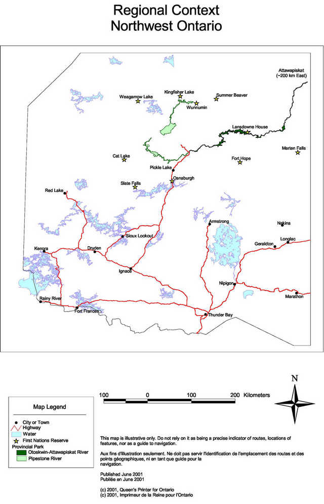
Enlarge Map: Regional Context Northwest Ontario
Map: Pipestone River Provincial Park Natural Environment Zones
Enlarge Map: Pipestone River Provincial Park Natural Environment Zones
Contact us
Ontario Parks
Northwest Zone
435 James Street South
Thunder Bay, Ontario P7E 6S8
Telephone: