Port Burwell Provincial Park Management Plan
This document provides policy direction for the protection, development and management of Port Burwell Provincial Park and its resources.
Port Burwell
Provincial Park
Management Plan
August, 1989
© 1989, Queen’s Printer for Ontario
Printed in Ontario, Canada
Additional copies of this publication are obtainable only from:
Ministry of Natural Resources
Aylmer District
353 Talbot Street West
Aylmer, Ontario
N5H 2S8
519-773-9241
Note: This document has been scanned and formatted, and therefore is slightly different from the original version - March 2002.
Approval statement
We are pleased to approve the Port Burwell Provincial Park Management Plan as official policy for the management and development of this park.
Through visitor surveys and the public review of planning for this park there was agreement that the new name of Port Burwell Provincial Park was more appropriate than the former name of Iroquois Beach Provincial Park.
This management plan reflects this Ministry’s intent to protect the natural features of Port Burwell Provincial Park and to maintain and develop high quality opportunities in outdoor recreation and heritage appreciation for residents of Ontario and visitors to the province.
Original signed by:
DJ. Johnstone
Regional Director
Southwestern Region
N.R. Richards
Director
Park and Recreational Areas Branch
1.0 Introduction
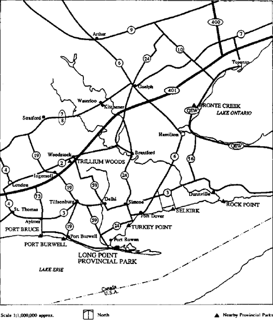
Port Burwell Provincial Park is a 227 hectare recreation class park located adjacent to the Lake Erie fishing village of Port Burwell, at the mouth of Big Otter Creek, Elgin County, Ontario (Figure 1). A private campground had been operated on part of the area for a number of years.
Acquisition of the area for a provincial park began in 1967 with the provincial government operation beginning shortly afterwards. The area was originally designated Iroquois Beach Provincial Park in 1971, with the official name changing to Port Burwell Provincial Park in 1986.
Current development in the park includes 232 campsites on the tableland above the lake, and two day use areas with associated parking lots on the beach plain. The nearest large urban centres are the Town of Tillsonburg (25 km north) and the City of London (65 km northwest).
Most park visitors are from the immediate area (Middlesex, Oxford and Elgin counties) and the most popular activities they engage in are swimming, sunbathing, and casual play. Visitor surveys indicate a high degree of visitor satisfaction and loyalty. Surveys indicate that over 80% of the visitors return to the park. Use of the park for camping has been increasing significantly. Campsite occupancy for July and August has risen from about 25% between 1974 and 1978 to over 70% in 1988.
The campground lies on the well treed and gently rolling Norfolk Sand Plain. The flat appearance of this sand plain contrasts with steep bluffs created by waves and currents where the plain meets Lake Erie, and with deep ravines which have been cut into the plain by creeks and rivers. The most outstanding feature of the park is the wide sandy beach providing excellent swimming, picknicking and sunbathing opportunities.
2.0 Classification
Port Burwell Provincial Park is classified as a recreation class park. Recreation parks are areas which support a wide variety of outdoor recreation opportunities for large numbers of people in attractive surroundings.
The excellent beach and impressive view of Lake Erie from the steep bluffs running through the park provide an outstanding setting for camping and day use.
3.0 Goal
The goal of Port Burwell Provincial Park is to provide a variety of outdoor recreation opportunities, and to protect the natural environment which consists of representative segments of the Norfolk Sand Plain and Lake Erie shoreline.
4.0 Objectives
Port Burwell Provincial Park contributes to the objectives of the Aylmer District Land Use Guidelines and the Ontario Provincial Park System emphasizing heritage appreciation, recreation and tourism, and protection of life science features in the following manner:
4.1 Protection
To protect provincially significant elements of the natural and cultural landscape of Ontario.
Port Burwell Provincial Park contains significant elements of the Norfolk Sand Plain, the Lake Erie Bluff, beach meadows and dune succession. Natural environment zones are designated to identify and manage these significant elements.
4.2 Heritage appreciation
To provide opportunities for exploration and appreciation of the outdoor natural and cultural heritage of Ontario.
Port Burwell Provincial Park will provide self- guiding trails with opportunities for visitors to learn about features in the park associated with the Norfolk Sand Plain, Lake Erie, and Port Burwell. The visitor services program will also provide information about these features by means of personal contacts, audio-visual presentations and publications.
4.3 Recreation
To provide provincial park outdoor recreation opportunities ranging from high intensity day use to overnight car camping.
Port Burwell makes a substantial contribution to the day use and camping targets assigned to the Ministry’s Aylmer District through the District Land Use Guidelines. The park has ample space and facilities to accommodate a greater amount of day use visitation on the beach. In addition, the park provides opportunities for quiet, close-to-nature day use experiences throughout the undeveloped westerly portion of the park.
Campsite occupancy is currently 70% in July and August. Although the campground was full several times in 1988, it is felt there are enough campsites in the park to meet demand over the next 10 years.
Figure 1: Regional Setting
4.4 Tourism
To provide Ontario’s residents and out-of-province visitors with opportunities to discover and experience the distinctive environment of the park and the surrounding area.
A marketing plan has been developed to increase tourist use (Section 8.3). This marketing initiative should lead to a wider awareness of the opportunities provided in the park. The park provides a convenient stop-over for tourists using the Talbot Trail, the provincially supported heritage highway along the Lake Erie shoreline.
5.0 Boundary
The park boundary will, over time, be extended to include three inholdings (Figure 2) as they become available and funds permit. In addition, the Ministry has negotiated with the Government of Canada for lands at the south end of Chatham Street. These lands were acquired to consolidate management of the beach and to prevent the possibility of future development which might conflict with park values.
Fencing of the western boundary will be required to delineate the boundary and separate park lands from adjacent agricultural lands.
6.0 Zoning
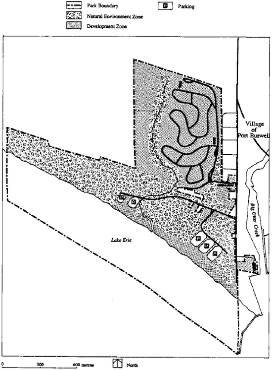
Two types of zones have been designated to guide the management of Port Burwell Provincial Park development and natural environment (Figure 3).
6.1 Development zone
This zone includes the existing campgrounds, day use areas and administration facilities. All intensive facility development will be confined to this zone. This zone contains approximately 49% (111 hectares) of the total park area.
6.2 Natural environment zone
This zone has a regionally significant area of natural interest containing low foredunes, a wet meadow complex, creek associations, ponds and sloughs. It also incorporates areas of unstable slopes, clay bluffs and associated vegetation. The area cannot support development. However activities such as hiking may occur on established trails.
This zone contains approximately 51% (116 hectares) of the total park area.
7.0 Resource management
The park will be managed in accordance with the Ontario Provincial Parks Planning and Management Policies for recreation class provincial parks. Specific direction, where needed to meet requirements specific to Port Burwell Provincial Park, is provided below.
Although the policies are presented in separate categories, all planning and management will recognize that these components are interrelated and that an integrated approach will be required in order for the park to achieve its objectives.
7.1 Water
Water quality in bathing areas is monitored in accordance with approved testing procedures to ensure public health and safety. Water samples are taken weekly and forwarded to the Ontario Ministry of Health for analysis. Port Burwell Provincial Park receives its drinking water from the Elgin Area Water System.
7.2 Dune stabilization
The present practice of using snow fence to restrict movement of sand will be continued at the end of Chatham Street. Use of vegetation to create a more natural windbreak will be examined, especially since this has proven to be effective at Pinery Provincial Park on Lake Huron. By stabilizing sand movement and causing dune building, the day use parking areas are protected from encroaching sand and possible flooding from Lake Erie during periods of high water and storms.
7.3 Vegetation
Vegetation in the park will be managed according to a vegetation management plan to fulfill protection and recreation objectives. Trees will be removed where there is a threat to human safety and property in the development zone and along the trails in the other zones. The plant communities and features in the Natural Environment zone will be allowed to evolve naturally.
Where rare, threatened or endangered species are discovered, specific management techniques may need to be applied to ensure their continued existence.
Grass mowing will be confined to development zones, and will be kept to the minimum necessary to maintain trails, campsites and roadway safety.
The Ministry of Natural Resources will initially respond to small brush and grass fires. There is also an agreement with the Village of Port Burwell whereby the fire department will respond to a fire in the park upon request. Insects as well as tree and plant diseases may be controlled, if feasible, when they become a threat to the natural or aesthetic values of the park, or the economic and natural values of the surrounding area. Non-native plant species will not be deliberately introduced, except in Development Zones for landscaping purposes and only where they will not have a detrimental impact on native plant communities in Natural Environment zones. Where possible non-native species will be removed from Natural Environment zones.
7.4 Fisheries
Smelt fishing along the beach will be permitted in the late spring. Off shore fishing by sportsmen is available in Lake Erie along the park beach. Commercial fishing is not permitted within the park boundaries, which extend from the water’s edge 402 metres out into Lake Erie.
7.5 Wildlife
Hunting will not be permitted in Port Burwell Provincial Park.
Management trapping will be permitted under the direct supervision of the Ministry of Natural Resources to manage nuisance and feral animals. Live trapping of nuisance animals will be permitted during the camping season if they become a health hazard to park users. Non- native species will not be introduced into the park.
8.0 Operations
A park Operating Plan will be prepared to provide park staff with the information required to operate the park on a day-today basis. The provisions of the plan will be consistent with the approved Ontario Provincial Parks Operating Standards, and will be reviewed annually and updated as required.
8.1 Visitor services
The visitor services program will provide visitors with an opportunity to gain an understanding and awareness of and an appreciation for, Port Burweli Provincial Park and the surrounding area. The primary intent of the program will be to increase visitor enjoyment thereby encouraging visitor to stay longer, to tell others about the park, and to become regular park users. Programs will be delivered by a combination of organized, structured activities such as conducted walks, outdoor programs and self-use unstructured opportunities.
8.1.1 Information
Information concerning park resources, management, facilities and programs, and nearby points of interest will be available at key points throughout the park, for example at the park office and the campground entrance. Information will consist of a park leaflet, newsletter and special publications as required.
8.1.2 Interpretation
The interpretive program will seek to create a greater understanding of the natural and cultural values of the park and will focus on the following themes: commercial fishing on Lake Erie, the colourful history of the Port Burwell area, geography of Norfolk Sand Plain and beach succession. The programs will involve personal contacts, audio visual presentations and publications. A multi-purpose activity shelter may be considered in the future. Groups or individuals will be encouraged to use the park resources for outdoor education purposes which are compatible with park policy and protection guidelines. Information about park resources will be made available to schools and other groups interested in outdoor education through the District Office in Aylmer.
Figure 2: Present Facilities and Proposed Acquisition Areas
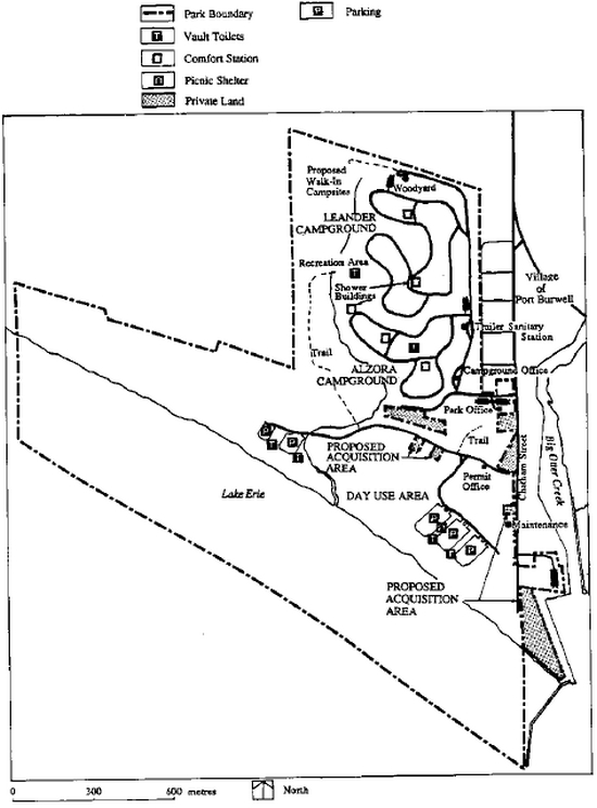
Figure 3: Zoning
8.1.3 Outdoor recreation
Recreation areas and equipment will be made available and their use promoted in an effort to increase the quality of the park visitor’s experience. Some organized activities will be scheduled throughout the summer season to further enhance this experience. Park staff will endeavor to inform visitors of recreational opportunities in the park and the surrounding local area. Programs devoted to water safety and other activities may be provided on a seasonal basis.
8.2 Research
Scientific research by qualified individuals, which contributes to knowledge of social and behavioral sciences and natural and cultural history, and to recreational and environmental management in Recreation Parks, will be encouraged in Port Burwell Provincial Park. All research programs will require the approval of the Ministry of Natural Resources and must also meet all requirements under applicable provincial and federal legislation. Recreation research may also be undertaken to evaluate the suitability of present programs, the satisfaction of the park visitors and visitor activity patterns. Natural science research may include periodic inspections for rare, threatened or endangered species, and the monitoring of vegetation, insect population and sand dune stabilization.
8.3 Marketing
A marketing plan has been developed for the park primarily to attract more visitors to the park throughout its operating season. The objectives of the plan are: to hold present clientele; to attract day users staying at local commercial establishments or using local services; to attract day users from urban centres within a 100 kilometre radius; to attract campers and day users during low-use periods in mid-week and the spring season; to increase involvement with the commercial sector by encouraging park users to take advantage of local tourist services and attractions; and, generally to promote interaction between the tourists, park and the commercial sector in the vicinity. Visitor services programming and promotion of the Park during the off season are both important ways of achieving the marketing objectives.
9.0 Development
Development will proceed in accordance with Figure 3 and the following guidelines. In all instances, detailed site plans will be completed and approved in advance of the development. This development will be focused on the improvement of existing facilities as part of the strategy to encourage visitors to stay longer. Development projects will be phased according to an implementation schedule (Section 10.0) and as funding permits. Consideration will be given to consolidating the separate campground and day use entrances into a new entrance. This entrance consolidation would be implemented through an amendment to this plan.
9.1 Campgrounds
The park will continue to offer 232 campsites distributed between the two campgrounds, Leander and Alzora. Three walk-in sites are proposed as described in the Aylmer District Land Use Guidelines, bringing the total campsites to 235. The walk-in sites will be located as shown in Figure 2 if a demand for this type of camping develops. No electrical outlets are provided at any campsites although the present electrical service in the park has sufficient capacity to permit installing outlets at 50 campsites. Installing some outlets may be considered if future visitor surveys suggest a strong demand for them.
9.2 Day use areas
In the day use area (Figure 2) one large picnic shelter has been constructed to accommodate group picnics. An additional picnic shelter is planned. Aging vault toilets will be replaced.
9.3 Park road system
The present internal roads are satisfactory but most will require some upgrading and hard surfacing. The Ministry will enter into an agreement with the Village of Port Burwell regarding maintenance responsibility for the park road leading to the private houses south of the Park Office.
9.4 Park office and maintenance buildings
The park office is adequate for the present, but minor alterations will be made to the maintenance yard to improve efficiency. If the 2 park entrances are consolidated after an amendment to this plan (section 9.0), the park office may be relocated.
9.5 Trails
The existing trail will be re-examined to determine if one self-guiding trail can be developed to meet the needs of both naturalists and hikers.
Hiking trails may be developed through the Natural Environment Zone.
10.0 Implementation
This plan guides the management of the park for the next twenty years, but review of the plan will be undertaken at least once every ten years, or sooner if required. The plan will be implemented in phases as demand requires and as funding permits.
The recommended projects will be implemented with formal approval of this management plan.
- Beach day use redevelopment
- Sand dune stabilization
- Boundary fencing
Phase II
- Hard surfacing roads
- Wellington Street redevelopment
Phase III
- Maintenance Area redevelopment
- Trail development
- Additional second car parking lot
Phase IV
- Walk-In campsites (if required)
- Entrance identification structures
- Hydro campsites
- Multi-purpose activity area
11.0 Public consultation
A local news release was prepared advising interested parties that a management plan was being prepared for Port Burwell Provincial Park.
Copies were also sent to the Village of Port Burwell, the Township of Bayham and the Long Point Region Conservation Authority for their comments.
An open house for local residents, interested park users and adjacent landowners was held to provide a public opportunity for asking questions and reviewing the draft plan. No major issues were raised during the consultation program.
12.0 Selected references
Ontario Ministry of Natural Resources. 1978. Ontario Provincial Parks Planning and Management Policies
Ontario Ministry of Natural Resources, Southwestern Region. 1979. Day Use and Camping Attendance Characteristics at Provincial Parks in the Southwestern Region.
Ontario Ministry of Natural Resources, Parks and Recreational Areas Branch. 1980. 1979 Day Visitor Summary Statistical Report.
Ontario Provincial Parks Act. Revised Statutes of Ontario 1980 Chapter 822.
Ontario Ministry of Natural Resources, Parks and Recreational Areas Branch. 1983. 1983 Provincial Park User Survey -Analysis of Data Report
Klinkenberg, R. 1984. A Reconnaissance Life Science Inventory of Iroquois Beach Provincial Park.
Ontario Ministry of Natural Resources, Southwestern Region.
Ontario Ministry of Natural Resources. 1985. Provincial Operating Standards Manual for Ontario Provincial Parks.
Minor amendment Port Burwell Provincial Park Management plan - May 2000
May 2000
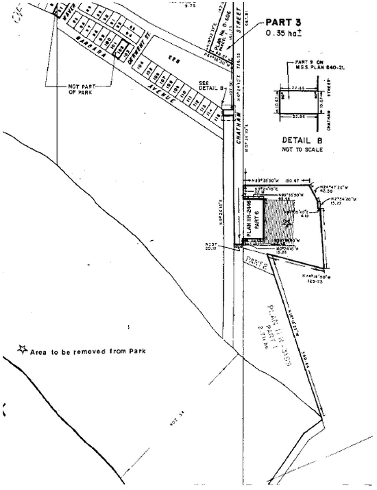
Issue: Minor amendment of the Port Burwell Provincial Park Management Plan (1989) to deregulate and transfer ownership of a parcel of land approximately 0.8 hectare in area, associated with Port Burwell Provincial Park, to the Municipality of Bayham to accommodate planned expansion of their existing sewage treatment plant.
Purpose: The purpose of the minor amendment is to allow for the retrofitting and expansion of the existing municipal sewage treatment plant (S.T.P) in Port Burwell to support improved and expanded sewage treatment for Port Burwell and the surrounding areas of Vienna, Eden and Staffordville. The area of land required for this expansion currently lies within the regulated boundary of Port Burwell Provincial Park.
Location: The property to be deregulated and transferred is located on the eastern side of Chatham Street, Village of Port Burwell, specifically Parts 6 and 7, Plan 2446 (please see attached map).
Background: Acres and Associated Consulting Engineers submitted an Environmental Study Report (ESR) to the Ministry of the Environment in June 1999. This document was an Addendum to the ESR's for the Eden, Vienna and Staffordville Sewage and Water Works in the Municipality of Bayham. The Addendum completed the Class Environmental Assessment for Municipal Water and Wastewater Projects for the Municipality of Bayham. As this process was carried out, the consultant and Municipality were responsible for holding a number of public meetings, notification of which was made through the local news media. Based on the evaluation carried out in the report, it was recommended that the existing sewage treatment plant in Port Burwell be retrofitted and expanded.
Under Exemption Order 59/2 of the Environmental Assessment Act, Ontario Parks notified adjacent landowners of the proposed amendment in February 2000. The mailing outlined the proposed amendment and was sent to those landowners within a radius of at least 125 metres of the proposed sewage treatment plant expansion site and to any other individual or organization who requested to be involved in the public consultation process.
The property to be deregulated and developed is located within the development zone of the park, where no vulnerable, threatened or endangered (VTE) species exist as it is primarily a gravel parking lot and disturbed field. Mitigation measures have been outlined by Acres and Associated for any of possible environmental impacts due to the expansion however these impacts will be minimal. Overall, the expansion will provide a net benefit to the lower Otter Creek valley and Lake Erie as effluent quality leaving the plant will meet the more stringent guidelines set out by the Ministry of the Environment thus improving water quality. At some future date, Port Burwell Provincial Park may hook into the municipal sewage treatment system and, as such, would also benefit from this proposed sewage treatment plant expansion.
Conditions: In return for the transfer of Parts 6 and 7 from Ontario Parks, the Municipality of Bayham will arrange the transfer of Part 5 to be registered to Ontario Parks. The Municipality also agreed to enter into discussion with Ontario Parks regarding the possible gating of the access road to the Port Burwell Provincial Park parking lot adjacent to Big Otter Creek. In addition, the Municipality will require Ontario Parks to grant easements for Part 9 to accommodate the existing sanitary sewer and to accommodate the proposed exfiltration gallery for the upgraded sewage plant.
Approval statement
This minor amendment to the Port Burwell Provincial Park Management Plan is approved to deregulate the above mentioned park property and transfer title it to the Municipality of Bayham to accommodate planned expansion of their existing sewage treatment plant.
Original signed by:
Henry Valks
Park Superintendent
Port Burwell Provincial Park
Date: June 21, 2000
Peter Sturdy
Zone Manager
Southwestern Zone
Date: June 15, 2000
Prepared by:
Tim Marchand
Parks Planner
Southwestern Zone
May 2000
Map showing Area to be removed from Park
Minor Amendment Port Burwell Provincial Park Management Plan - October 2001
October 2001
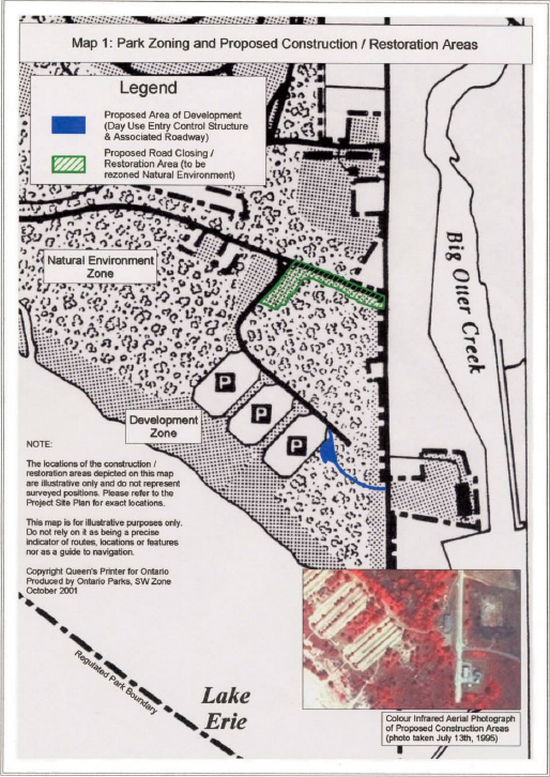
Issue: A minor amendment to the Port Burwell Provincial Park Management Plan (1989) is necessary to adjust the Development and Natural Environment zoning of the park and to accommodate the construction of a new day use entry control structure and associated roadway.
Purpose: The purpose for the construction of a new day use entry control structure is to replace the existing obsolete day-use entry control building with a new and updated structure to provide washroom facilities and increased security for park staff. The proposed day-use entry control structure will allow for the possible consolidation of the day use and campground offices.
Background: The existing day use entry control building is in a state of disrepair and should be replaced. The proposed site of the new building will allow for an expansion to possibly accommodate a campground office (as outlined in the approved park management plan) and a small park store:
Section 9.0 Development of the Park Management Plan states that:
Consideration will be given to consolidating the separate campground and day use entrances into a new entrance. This entrance consolidation would be implemented through an amendment to this plan."
Feasibility: Prior to deciding upon the current proposed location of the day-use entry control building and associated roadway, a number of alternative site locations were considered. These scenarios included (a) utilizing the existing day-use gatehouse footprint and roadway, (b) constructing the proposed day-use entry control building along the existing maintenance roadway and (c) installing the proposed day-use entry control building and an associated roadway east of Parking Area #1. An environmental analysis was completed for each of these alternatives. The environmental analyses involved the review of existing life science, earth science, and archaeological information. In addition, ecological site visits were conducted in March, May, June, August and September 2001 by qualified Ministry of Natural Resources staff.
Based upon the results of the environmental analyses, Scenario (c) was determined to be the preferred location for the construction of the proposed day-use entry control building. The site is situated in the southeasterly portion of the park immediately adjacent to day-use Parking Lot #1 and west of County Road #39. This proposed area of construction is situated primarily within the Development and Natural Environment zones of the park (see Map #1). The new site is situated closer to parking facilities and will allow for smoother and safer traffic flow. Furthermore, the level of security in this area will increase as park staff will be able to view the three most heavily used of the five parking lots thus minimizing potential vehicle vandalism and theft. In times of emergencies, the public will also be able to contact park staff more quickly.
Zoning: The preferred site scenario requires that a small portion of the Natural Environment zone be rezoned as Development zone (approximately 0.2 hectares). The existing day-use entry roadway is situated within an approximate Development zone area of 0.6 hectares. Once closed and rezoned to Natural Environment zone, this area will ensure that there is no net loss of Natural Environment zone. In fact, there will be a slight overall increase (approximately 0.4 hectares) in Natural Environment zone. The restoration of this area and it’s rezoning to Natural Environment will contribute to minimizing habitat fragmentation within the park.
Mitigation/Restoration: The proposed day-use entry control building will require utility hook-ups to be installed (i.e., water, sewage, hydro and telephone). All new utility lines will utilize existing service lines where possible. The proposed sewage line will be buried immediately adjacent to the planned roadway to minimize any potential impacts associated with its installation.
The existing day-use roadway will be closed, restored and rezoned from Development to Natural Environment Zone (see Map #1). The species to be planted and the techniques used in the restoration will be determined through the preparation of a restoration plan prior to undertaking this aspect of the project.
It is anticipated that the restoration of the existing day-use roadway will involve the scarification of area to be followed by seeding or planting of native plant species known to provide suitable habitat for species located within or adjacent to the park. To ensure that the newly restored area is not negatively impacted, fencing and appropriate signage will be employed to prohibit vehicular or pedestrian traffic through the restored area.
Rationalization: According to Ontario Parks Policy 11.02.03 Park Management Plan Amendment and Review, a minor amendment "involves changes to development or management policies of a less significant nature". Specifically, this amendment is not viewed to have a significant impact on the park’s environment, adjacent landowners or users and it is not expected to result in significant public reaction on a local, regional, or provincial scale. Based upon the environmental analyses, site visits and public consultation completed to date, the mitigation/restoration measures to be employed and the inherent improvements in park user safety, security and accessibility, this amendment is considered to be ‘minor' as:
- A new entry control structure is addressed in the approved Park Management Plan
- Changes in park zoning will be minor with no net loss to area of Natural Environment zone
- Ecological inspections revealed no impacts on Species at Risk
- Through consultation with the Ministry of Tourism, Culture and Recreation, there are no known archaeological sites within the area
- At such time as a new entrance and day-use entry control structure is constructed, the former entrance and gatehouse will be removed and the site will be restored to a natural area
Public Consultation: Ontario Parks Bulletin 11.03.01 Guidelines for the Preparation of Implementation Plans indicates that:
when projects or activities fall into Category A [with respect to their EA implications], the assumption is that there are sufficient checks and balances in place to mitigate potential environmental impacts. As such, no additional planning or consultation are required, although public notice may still be provided."
Public consultation was undertaken as a component of this project. Under Exemption Order MNR-59/2 of the Environmental Assessment Act, adjacent landowners were notified of the proposed amendment. Copies of the proposed amendment and the implementation plan were mailed to adjacent landowners within a minimum 125-metre radius of the proposed development site and to local stakeholder groups.
During the week of July 16th, 2001, two paid advertisements were placed in local newspapers, on-site notices were posted at the park and a notice outlining the proposed project was mailed to 69 adjacent landowners. In addition, copies of all plans and any other additional information prepared for the project were made available to the public for examination at the Port Burwell Provincial Park office. The 45-day public consultation period extended until August 31st 2001. A total of five inquiries requesting further information were made to the park. There were no significant issues or concerns raised as a result of the public consultation process.
Conditions: In accordance with Exemption Order MNR-59/2, made under the Environmental Assessment Act (respecting the carrying out of the Provincial Parks program) at least 45 days in advance of the construction:
- The Ministry of Environment will be notified
- Prior to construction, an archaeological assessment will be conducted by a licensed archaeological consultant to identify any potentially significant deposits and suggest appropriate measures to mitigate any potential impacts
- A copy of all plans or additional information prepared for such projects will be available to the public upon request for examination at the Port Burwell Provincial Park office
Approval statement
This minor amendment to the Port Burwell Provincial Park Management Plan is approved in order to facilitate the required rezoning and to permit the construction of a new day use entry control building and associated roadway.
Original signed by:
Henry Valks
Park Superintendent
Port Burwell Provincial Park
Date: October 31, 2001
Peter Sturdy
Zone Manager
Southwestern Zone
Date: December 10, 2001
Prepared by:
Tim Marchand
Assistant Parks Planner
Ontario Parks, Southwest Zone
October 2001
Map 1: Park Zoning and Proposed Construction/Restoration Areas