Presqu'ile Provincial Park Management Plan
This document provides policy direction for the protection, development and management of Presqu'ile Provincial Park and its resources.
October 2000
Prepared by Anthony Usher Planning Consultant
Maps prepared by Conversion Integration & Management Services and Y.W. Lee Associates
© 2000, Queen’s Printer for Ontario
Additional copies of this publication are available from the Ministry of Natural Resources for $5.00 plus GST per copy, at the Presqu'ile Provincial Park office or by mail from:
Park Superintendent
Presqu'ile Provincial Park
R.R. 4
Brighton, Ontario K0K 1H0.
(613) 475-4324
Approval statement
"I know of no other provincial park or any area in all of southern Ontario that includes so much diversity of natural communities in so small an area. The woods, the marshes, the beach, the Islands, the fields, the sheltered bay and the open waters of Lake Ontario; Presqu'ile has it all." - Barry Kent MacKay, foreword to Birds of Presqu'ile Provincial Park, 1993.
I am pleased to approve the Presqu'ile Provincial Park Management Plan as the official policy for the management and development of this park. The plan reflects the intent of Ontario Parks to protect the natural and cultural features of Presqu'ile Provincial Park, and maintain and develop high quality opportunities for outdoor recreation and heritage appreciation for both residents of Ontario and visitors to the province.
Signed by:
Adair Ireland-Smith
Managing Director
Ontario Parks
October 2000
Foreword
This approved Management Plan represents the third and final stage in the preparation of a management plan for Presqu'ile Provincial Park. In the first stage of the planning process (1995-96), Presqu'ile Provincial Park: Background Information/Issues and Alternatives was produced and distributed for public review. In the second stage (1996-99), a Preliminary Management Plan was produced and reviewed by the public.
The Ministry of Natural Resources (MNR) is responsible for managing Ontario’s natural resources in accordance with the laws it administers. As the province’s lead conservation agency, MNR is the steward of provincial parks, natural heritage areas, forests, fisheries, wildlife, mineral aggregates, fuel minerals, and the Crown lands and waters that make up 87% of Ontario.
In 1994, MNR completed its Statement of Environmental Values as required by the Environmental Bill of Rights, 1993. The Statement indicates how the purposes of the Environmental Bill of Rights are to be considered whenever MNR makes decisions that might significantly affect the environment.
In 2000, MNR released Beyond 2000, which identifies the Ministry’s vision of sustainable development and its mission of managing Ontario’s natural resources in an ecologically sustainable manner. The supporting strategies of Beyond 2000 are also considered in MNR land use and resource management planning.
During the development of this Management Plan, MNR has considered both of these documents. This park management plan is intended to reflect the directions set out in them, and to further the objectives of managing Ontario’s resources on a sustainable basis.
1. Introduction
Presqu'ile’s uniqueness as a landform, expressed in its name - "almost an island" - underlies everything else that is special about it. The foot of Presqu'ile Peninsula was once a limestone island, as Gull and High Bluff islands still are. Over hundreds of years, sandspits from the island and mainland grew towards each other and eventually joined to form a tombolo (a barrier beach linking a former island with the mainland). Today, the Presqu'ile tombolo includes tremendous diversity within a narrow strip: a sand beach on Popham Bay, two ridges of dunes, a seasonally wet meadow between the dune ridges (the panne), and finger-like points curving into Presqu'ile Bay Marsh (the Fingers). It is the largest, and the best example of, a tombolo on the Great Lakes and within the provincial parks system.
The park’s physical characteristics combine with its location on Lake Ontario and near major population centres to make it significant in several other ways.
- The panne is the best example of its kind on Lake Ontario and is home to an internationally significant plant community
- The park is home to other important environments, including part of Presqu'ile Bay Marsh, recognized as a provincially significant wetland
- The park provide:; internationally significant habitats for bird nesting and bird and monarch butterfly migration, and is in the top rank of places to see birds in the top rank of places to see birds in Ontario
- The peninsula’s hazards for navigation discouraged settlement, caused Presqu'ile Lighthouse (the oldest easily accessible operating light on the Ontario side of the Great Lakes) to be built, and kept most of the peninsula as public land until park status became a possibility
- The sand beach is one of the outstanding recreational beaches on Lake Ontario’s north shore. East of Toronto and south of Algonquin Provincial Park, Presqu'ile is the second most visited Ontario provincial park for day use and the third or fourth most visited for camping, and its heritage education program is the most used
Presqu'ite Park was established by a special Act in 1922 and was managed for the next three decades by the locally based Presqu'ile Park Commission. In1954, the Presqu'ile Park Act was repealed, and the park became Presqu'ile Provincial Park under the Provincial Parks Act. Two years later, the Commission was disbanded, and the park came under the direct administration of the Department of Lands and Forests, now MNR. In 1996, operation of Presqu'ile and other provincial parks was assumed by Ontario Parks, a new organization within MNR. The mandate of Ontario Parks is to protect, plan, develop and manage Ontario’s system of provincial parks while improving the self-reliance of Ontario Parks.
As of January 1, 2001 when the Town of Brighton and Township of Brighton will amalgamate, the park will lie entirely within the Municipality of Brighton. The park entrance is 4 km from Brighton town centre and 9 km from the Highway 401 interchange with Northumberland County Road 30. Map 1 shows the park’s setting within east central Ontario, and its relationship to other provincial parks, protected areas, and recreational features.
Detailed information on the park’s setting, facilities, natural and cultural heritage, and markets and use is provided in the Background Information/Issues and Alternatives document, available from Ontario Parks.
The approved Management Plan will guide the development, management, and operation of Presqu'ile Provincial Park over the next 20 years. Section 10 describes the process for review and amendment of the plan.
The policies in this plan will not abrogate or derogate from any Aboriginal or treaty right recognized or affirmed by the Constitution Act.
2. Public consultation and significant issues
2.1 Background information/issues and alternatives
The public was first invited to participate in management planning for Presqu'ile Provincial Park in August and September 1995, through a mailing to individuals and groups then known to be interested, advertisements in area newspapers, and placement on the Environmental Registry under the Environmental Bill of Rights, 1993. In November 1995, a Public Involvement Plan was mailed to those on the mailing list.
On November 28, 1995, a workshop for 11 key interest groups was held in Brighton. The workshop’s purpose was to allow the participants to become better acquainted with each other, and search for common ground on, and solutions to, difficult issues.
Map 1 - Regional Setting
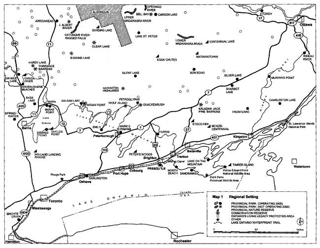
Enlarge Map 1 - Regional Setting
About 1,000 copies of the April 1996 Background Information/Issues and Alternatives document, along with a revised Public Involvement Plan, were distributed through:
- a mailing to the 242 individuals and groups then on the mailing list
- an open house in Brighton on June 22, 1996, attended by about 100 people
- mailing, and over the counter distribution at the park, in response to individual inquires
The Background Information/Issues and Alternatives document and the open house were also publicized through advertisements in area newspapers in June 1996.
Included with the document was a questionnaire. Respondents were invited to submit comments in addition to or in place of the questionnaire if they wished. Respondents were asked to bring their questionnaires and/or comments to the Brighton open house, or return them to Ontario Parks by August 6, 1996. Ontario Parks received 185 responses.
Also in summer 1996, a survey of Presqu'ile day visitors and campers was conducted (visitors to each operating provincial park are surveyed every few years). In addition to the standard questions asked at all parks, questions about management planning were added at Presqu'ile.
Section 2 of the Preliminary Management Plan identified the issues most commented on by the public during review of the Background Information/Issues and Alternatives document. Highlights of the public responses to Background Information/Issues and Alternatives and the park visitor survey responses were provided in an Appendix to the Preliminary Plan. Background Information/Issues and Alternatives: Summary of Public Response (November 1996) provides more detail and is available from Ontario Parks.
2.2 Preliminary Management Plan
About 1,000 copies of the February 1999 Preliminary Management Plan were distributed through:
- a mailing to the 556 individuals and groups then on the mailing list
- an open house and public meeting in Brighton on March 25, 1999, attended by about 500 people
- mailing, and over the counter distribution at the park, in response to individual inquiries
The Preliminary Plan and the open house and public meeting were also publicized through advertisements in area newspapers in February 1999.
Because of the very high level of public interest in the Preliminary Plan, during the review period Ontario Parks also:
- met with several key interest groups
- issued Preliminary Management Plan: Questions and Answers in June 1999, to clarify issues of concern in the Preliminary Plan and indicate some of the changes being considered, and mailed it to about 2,800 individuals and groups then on the mailing list
- issued to key interest groups and the media in July 1999 a summary of proposed changes to the Preliminary Plan
Preliminary plan recipients were invited to submit comments to Ontario Parks by April 23, 1999, later extended to August 31, 1999. Ontario Parks received 169 responses from 147 individuals and interest groups, and 2,409 form letters. In addition, those attending the public meeting were given comment sheets; 234 were returned.
Preliminary Management Plan: Summary of Public Meeting - Brighton, March 25, 1999 (June 1999) summarizes what was said at the public meeting. Preliminary Management Plan: Summary of Public Response (October 2000) summarizes all written responses to the Preliminary Plan, including the public meeting comment sheet. Both documents are available from Ontario Parks.
The following proposals emerged as the most significant issues during public review of the Preliminary Plan:
- Changing the water boundary in Presqu'ile Bay
- Prohibiting motorboating in most park waters in Presqu'ile Bay
- Adding Salt Point to the park
- Closing the Calf Pasture Point boat launch
- Managing the sand beach for both bird migration and beach recreation
- Removing the picnic facilities north of the park store
- No policy on cormorant control
- Changing municipal official plans to better protect park values
- Community involvement in plan implementation
Management Plan: Ontario Parks Position on Major Issues (October 2000), available from Ontario Parks, explains the position of Ontario Parks on these and other issues raised by the public, and indicates the changes made in this approved Management Plan as a result. Other minor changes have been made to the Preliminary Plan, to reflect changed conditions or conform with Ontario Parks requirements for approved management plans.
Finally, from 1997 on, a separate process was conducted for one significant issue, waterfowl hunting.
In fall 1997, the Minister of Natural Resources, the Honourable John Snobelen, asked the Board of Directors of Ontario Parks for its opinion on this issue. On February 18, 1998, the Ontario Parks Board adopted the following recommendation by consensus:
"that the Presqu'ile Provincial Park Preliminary Management Plan should call for waterfowl hunting to be phased out over a period of no more than five years, provided that the Ministry of Natural Resources, working in partnership with conservation organizations, develops alternative hunting opportunities for big water diver duck hunting.”
In April 1999, the Minister appointed a committee representing the Ontario Federation of Anglers and Hunters, the Federation of Ontario Naturalists, and Brighton area waterfowl hunters and naturalists, and facilitated by Ontario Parks staff, to advise him on the feasibility of implementing the Ontario Parks Board recommendation. The committee concluded its work in May 2000.
3. Park policies
3.1 Classification
Presqu'ile Provincial Park will continue to be classed as a natural environment park, one of six classes of parks in the Ontario provincial parks system. The other classes are wilderness, waterway, nature reserve, historical, and recreation.
Natural environment parks incorporate outstanding recreational landscapes with representative natural features and historical resources to provide high quality recreational and educational experiences. Presqu'ile clearly has all these attributes.
3.2 Goal
The goal for the park is:
- To protect Presqu'ile Provincial Park’s outstanding natural and cultural heritage, and provide high quality recreational and educational experiences appropriate to and sustainable within the park’s environment.
3.3 Objectives
The Ontario provincial parks system has four objectives: protection (which is the park system’s paramount objective), heritage appreciation, recreation, and tourism. As a natural environment park, Presqu'ile will contribute to all four objectives.
The objectives for Presqu'ile Provincial Park are as follows.
3.3.1 Protection
- To protect significant elements of the park’s natural and cultural heritage
For park system planning purposes, Ontario is divided into 67 site districts based on landforms and biological productivity. Presqu'ile and Sandbanks provincial parks are the two natural environment parks in site district 6-15, and protect natural environments representative of this site district. The specific significant natural and cultural features protected in the park’s nature reserve, historical, and natural environment zones are described in Section 5.
Protection will not be limited to provincially significant features. The entire park will be maintained as a healthy, diverse, and sustainable natural environment, consistent with achieving the park’s other objectives. The restoration of degraded environments will be given a high priority.
3.3.2 Heritage Appreciation
- To provide opportunities for exploration and appreciation of the park’s natural and cultural heritage
Within the limits of the need to restrict access to certain areas at certain times to protect natural heritage values, the entire park is very suitable for heritage exploration and appreciation. A full range of opportunities will be provided, from unstructured individual exploration to organized programs and interpretive centres. Specific heritage education facilities and services are described in Section 7.1.
3.3.3 Recreation
- To provide day use and camping recreation opportunities appropriate to the park
Swimming, walking and hiking, picnicking, and camping are expected to continue to be the principal recreational activities in the park. Camping and day use will be maintained near present levels in summer. Ontario Parks will seek to increase camping and day use in the spring, fall, and winter, by increasing heritage appreciation opportunities and improving the suitability of existing park facilities.
3.3.4 Tourism
- To provide Ontario residents and visitors with opportunities to discover and experience the park’s natural, cultural, and recreational environment
Tourism opportunities will be enhanced by achieving the park’s other objectives, and by working with area municipalities and community groups to develop and promote Presqu'ile-Brighton as a primary tourism and recreation destination. The park itself will be promoted on the basis of its natural and cultural heritage values and recreational opportunities, and appropriate enjoyment and appreciation of those values and opportunities. Increasing visitation and revenues will provide more funds to help achieve the park’s protection and heritage appreciation objectives, and to help improve the self-reliance of the overall provincial parks system in accordance with the mandate of Ontario Parks. Tourism development initiatives are further described in Sections 7.5, 7.6, 9.2, and 9.3.
3.4 International conservation designations
Ontario Parks will support designation of Presqu'ile Provincial Park under any international conservation initiative that will recognize and promote the park’s natural and cultural heritage, provided that designation does not have any implications inconsistent with continued ownership and operation of the park by the Province or with this plan.
In 2000, the park was recognized as a globally significant Important Bird Area (IBA) within the North American Important Bird Areas Program. This program is an international effort to identify, conserve, and monitor a network of sites that provide essential habitat for bird populations. The IBA program’s partners in Ontario, Bird Studies Canada, the Canadian Nature Federation, and the Federation of Ontario Naturalists, released a Presqu'ile Important Bird Area Conservation Plan in August 1999. Any initiative taken under the IBA plan within the park must be consistent with the park management plan.
As of 2000, other potential designations are:
- As a Wetland of International Importance under the Convention on Wetlands of International Importance Especially as Waterfowl Habitat (Ramsar Convention)
- As a Regional Reserve within the Western Hemisphere Shorebird Reserve Network
- As a Monarch Butterfly Reserve under the Canada-Mexico Declaration on Creation of an International Network of Monarch Butterfly The monarch butterfly is designated as a species of special concern in Canada
4. Boundary and land tenure
4.1 Boundary
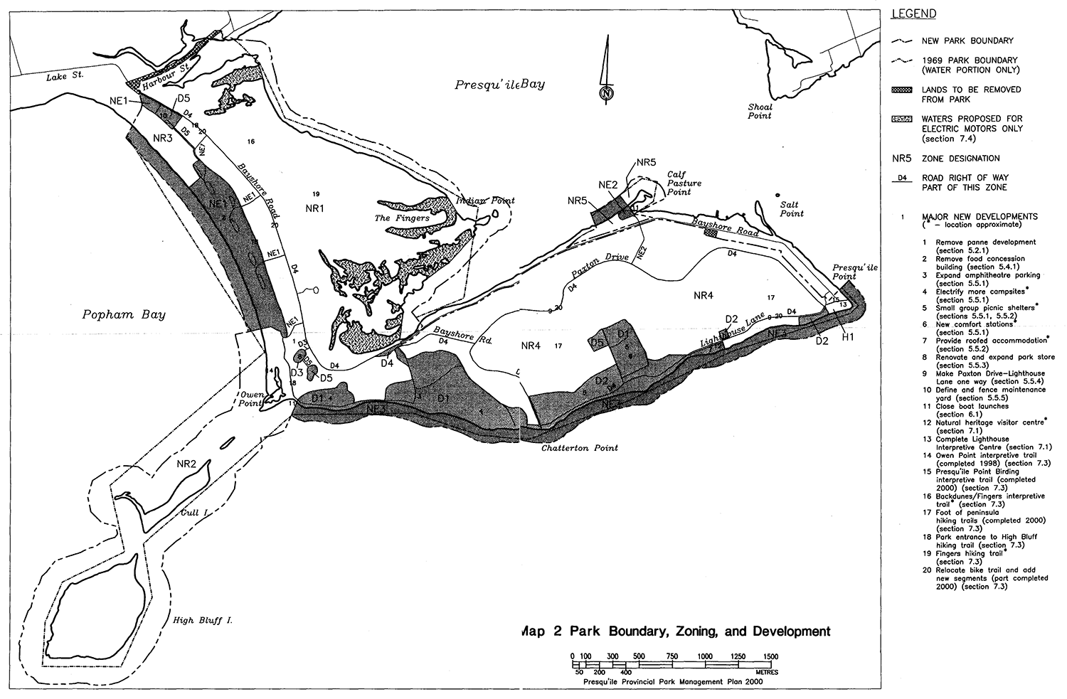
Maps 2 through 6 in the Background Information/Issues and Alternatives document show the boundary of Presqu'ile Provincial Park as last amended in 1969 by Ontario Regulation 86/69. According to boundary surveys up to that time, the park’s area is 937 ha and this value has been used up to now. However, as a result of computerized mapping of the park, the area within the 1969 boundary has been recalculated at 894 ha.
Map 2 in this plan shows the park boundary as the Ontario Government intends to amend it by regulation, and this plan assumes the new boundary to be in place. The park’s area will increase to an estimated 974 ha.
The following changes will be made-to park lands (see Map 2).
- Harbour Street and its road allowance along the northern boundary of the park including the junction of Lake and Harbour streets and Bayshore Road, totalling 9 ha, will be removed from the park. The Municipality of Brighton, and before it the Town of Brighton and County of Northumberland, have for many years undertaken all construction and maintenance within this right of way, which also includes the Lake Ontario Waterfront Trail
- Two privately owned residential properties on Bayshore Road near the federal dock, totalling 6 ha, will be removed from the park. They appear to have been inadvertently included within the 1969 boundary
Salt Point will not be added to the park. It will remain Crown land and MNR will manage it accordingly, either on its own or through partnerships.
The water boundary of the park will be entirely revised, based on the following principles.
- The boundary is being extended off the marsh and sand beach to accommodate recent and anticipated growth of the tombolo
- The boundary will generally be defined on the basis of distance from shore
- Adequate water access outside the boundary will continue to be provided to all Presqu'ile Peninsula residential properties
The new boundary will add to the park an estimated net total of 84 ha of water, including areas that were mapped as water in boundary surveys up to 1969 and have since become land. All beds of waters, and all lands that have emerged since the 1969 and earlier boundary surveys, are owned by the Province.
For boundary purposes, the shore is defined as wherever it actually is at any time. Therefore, where the water boundary is a set distance from shore, it will fluctuate along with the shoreline, as water levels change in the short term and the shoreline moves in the long term. The new boundary and park and zone. areas in this plan are based on the shoreline as shown on Map 2, which represents conditions in 1979.
The park boundary will be surveyed to current standards to the extent required for it to be precisely defined in the computerized mapping of the park, as well as on the ground where necessary. The park superintendent will more clearly define the boundary on land (by signage, planting, or fencing as appropriate) and on water (by signage or fixed or floating markers as appropriate), where needed to protect park values and achieve the policies of this plan.
Most if not all of the park qualifies as natural heritage features and areas as defined by the Provincial Policy Statement under the Planning Act. Planning authorities are required to have regard to provincial policy that natural heritage features and areas are to be protected from incompatible development on adjacent lands. MNR will recommend to the Ministry of Municipal Affairs and Housing that the Municipality of Brighton be asked to ensure that its official plans appropriately identify the park’s lands and waters, so that new development near the park is assessed with regard to any potential impacts on the park’s natural heritage values in accordance with provincial policy.
4.2 Land Tenure
This plan recognizes the continuing use of park lands by Hydro One Networks Inc. (formerly part of Ontario Hydro), which holds an easement across park lands to provide service to the park and the Presqu'ile Peninsula residential area.
Although the Province owns Presqu'ile Lighthouse, the Government of Canada has authority to operate, maintain, and alter the lighthouse, as well as the High Bluff Island navigation beacon. This authority is not currently limited by any federal or provincial heritage protection legislation.
Presqu'ile Lighthouse is important to the park and community as a historical resource, landmark, and symbol. Ontario Parks will work with the Government of Canada to ensure that any alterations desired by the federal government are compatible with the lighthouse’s value to the park and community.
5. Park zoning
5.1 Zoning policy
The lands and waters of Presqu'ile Provincial Park are zoned on the basis of their significance for protection and potential for recreation and development. There are five nature reserve, one historical, three natural environment, and five development zones in the park, as shown on Map 2. There are no landscapes in the park of the size and integrity needed to qualify as wilderness zones.
The zone boundaries are shown in more detail on the computerized mapping of the park. It may be necessary to delineate some zone boundaries more precisely on the ground, and this will be done as required.
The following sections briefly describe each zone. The resource uses, recreational uses, and types of development permitted in each type of zone are shown in Table 1. All resource and recreational uses and facility development will be subject to the standard legislation and policies governing provincial parks and public lands and resources, as well as the policies in Sections 6, 7, and 8.
In this plan, "species at risk" means species listed by MNR on its Index List of Vulnerable, Threatened, Endangered, Extirpated or Extinct Species of Ontario, including:
- species named by regulation under the Endangered Species Act
- species designated as vulnerable or threatened in Ontario by MNR's Committee on the Status of Species at Risk in Ontario (COSSARO)
- species designated as of special concern (formerly vulnerable), threatened, or endangered in Canada by the Committee on the Status of Endangered Wildlife in Canada (COSEWIC)
Species at risk listings are as of May 2000 and are subject to change.
Table 1 - Permitted uses and development
The permitted uses and development policies in this table will not abrogate or derogate from any Aboriginal or treaty right recognized or affirmed by the Constitution Act.
| Resource uses permitted, in accordance with provincial parks policies | Nature reserve zones | Historical zone | Natural environment zones | Development zones |
|---|---|---|---|---|
| Commercial fishing 1 | Permitted | Not permitted/not possible | Permitted | Not permitted/not possible |
| Trapping 2+7 | Permitted/NR1,NR5 3 | Not permitted/not possible | Not permitted/not possible | Not permitted/not possible |
| Recreational uses permitted4 | Nature reserve zones | Historical zone | Natural environment zones | Development zones |
|---|---|---|---|---|
| Swimming | Permitted | Not permitted/not possible | Permitted | Not permitted/not possible |
| Canoeing | Permitted | Not permitted/not possible | Permitted | Not permitted/not possible |
| Motorboating 5 | Permitted/NR1,NR5 6 | Not permitted/not possible | Permitted | Not permitted/not possible |
| Boat launching 5+7 | No permitted | Permitted | Permitted | Permitted |
| Walking/hiking | Permitted | Permitted | Permitted | Permitted |
| Cycling | Permitted8 | Permitted8 | Permitted8 | Permitted |
| Cross-country skiing | Permitted | Permitted | Permitted | Permitted |
| Sport fishing | Permitted | No permitted | Permitted | Not permitted/not possible |
| Waterfowl hunting | Permitted/NR1",NR2, NR5 9 | No permitted | Permitted/NE3 9 | Not permitted/not possible |
| Car and group camping | Not permitted/not possible | Not permitted/not possible | Not permitted/not possible | Permitted/D1 |
| Heritage appreciation | Permitted | Permitted | Permitted | Permitted |
| Development permitted | Nature reserve zones | Historical zone | Natural environment zones | Development zones |
|---|---|---|---|---|
| Walking trails | Permitted | Permitted | Permitted | Permitted |
| Bike trails | Permitted 10 | Permitted | Permitted/NE3 11 | Permitted |
| Basic day use facilities 12 | Permitted 13 | Permitted | Permitted | Permitted |
| Intensive day use facilities 14 | No permitted | No permitted | Permitted/NE1 15/NE3 16 | Permitted |
| Waterfowl hunting blinds | Permitted/NR1, NR2, NR5 9 | No permitted | Permitted/NE3 9 | Not permitted/not possible |
| Campgrounds | Not permitted/not possible | Not permitted/not possible | Not permitted/not possible | Permitted/D1 |
| Roofed accommodation | No permitted | No permitted | Permitted/NE3 16 | Permitted/D2 |
| Historical restorations and modifications | No permitted | Permitted | Permitted/NE3 17+16 | Permitted/D2 |
| Interpretive facilities | Permitted 18 | Permitted | Permitted 18 | Permitted |
| Park research and management facilities | Permitted 19 | Permitted | Permitted/NE1,NE2 19/NE3 19+16 | Permitted |
| Visitor information and service facilities | Not permitted/not possible | Permitted18 | Permitted/NE1 18/NE3 18+16 | Permitted |
| Access roads and parking | Permitted 20 | Permitted 21 | Permitted | Permitted |
| Main roads 22 and entry station | Not permitted/not possible | Not permitted/not possible | Not permitted/not possible | Permitted/D4 |
| Necessary signs | Permitted | Permitted | Permitted | Permitted |
Notes to Table 1
xx/ - Permitted in zone(s) xx only.
xxi/ - Permitted in zone(s) xx only, and only under the conditions in note i.
1 Including boating by resource harvesters licensed to harvest in the park, while engaged in harvesting.
2 Until January 1, 2010 (see Section 6.5).
3 Outside the 1969 park boundary only.
4 Only those recreational uses of interest to the largest numbers of people are listed here. Other uses will be permitted or prohibited by analogy to the uses listed, or in accordance with the planning and management policies for natural environment parks. For example, kayaking will be treated in the same way as canoeing; snowshoeing, in the same way as cross-country skiing.
5 As long as waterfowl hunting is permitted in the park in accordance with Section 6.5, waterfowl hunters holding a daily blind permit for the park will, on the day that permit is valid, not be subject to the restrictions shown for this use.
6 Ontario Parks wishes motorboating to continue as a continuing nonconforming use in Zone NR1 (with restrictions) and Zone NR5. Because the regulation of motorboating on Lake Ontario is within federal jurisdiction, Ontario Parks will seek a Boating Restriction Regulation under the Canada Shipping Act to prohibit motorboating, except using electric motors, in the inlets of Zone NR1 as shown on Map 2, and to prohibit all motorboating in Zone NR2. Federal regulations already generally limit speeds to 10 km/h within 30 m of shore.
7 Carrying in and launching cartop boats such as canoes, sailboards, and small outboards only.
8 On roads and designated trails only.
9 As described and in accordance with the conditions in Sections 6.5 and 6.1
10 Existing bike trail only, where it forms the boundary between Zones NR1 and NR2.
11 Alongside existing roads only.
12 Individual picnic sites, drinking water, vault privies, etc.
13 Vault privies only, as required to support walking trail use only.
14 Picnic shelters, group picnic areas, comfort stations, etc.
15 Change houses, comfort stations, and temporary picnic shelters only.
1616 Existing development only; permitted as a continuing nonconforming use (see Section 5.4.3).
17 Existing Lighthouse Lane cottages and sites only.
18 Minimal facilities only.
19 Temporary facilities only.
20 For access to walking trails only.
21 For access to Lighthouse Interpretive Centre only.
22 Bayshore Road, Lighthouse Lane, Paxton Drive.
The park superintendent has the authority under the Provincial Parks Act to close any part of the park, land or water, to any use, or to restrict any use, for any period of time. In public use areas, this authority would only be used for emergency closures, either to protect park values (such as mass shorebird groundings on the beach, or nesting by species at risk in the marsh), or to ensure public safety.
Ontario Parks will prepare resource management plans for individual zones, to guide landform, vegetation, and wildlife habitat management and restoration. In historical, natural environment, and development zones, these plans would also guide recreational management. Along with the policies in Section 6, specific principles to be adhered to in preparing each zone resource management plan will include the following.
- The aim of management and restoration will be to:
- in nature reserve zones, perpetuate the natural heritage values which the zone has been established to protect
- in natural environment zones, perpetuate natural heritage values to the extent that the zone has been established to protect them
- in historical and development zones, protect significant natural heritage values that are present
- "Management and restoration" will generally mean maintaining natural environments in, or restoring them to, their original condition as nearly as possible, at which point those environments will be left to evolve naturally and without human interference, except as specifically prescribed in this In some cases, continuing active management to maintain a particular habitat condition or stage of natural succession that does not represent original conditions (for example, an old field) may be justified if it contributes to the park’s overall biodiversity
- "Original condition" means natural conditions before European It embodies not only natural succession and an absence of post-settlement human interference, but also the original quality, integrity, and diversity of the environment
- Natural processes will be used except where other approaches are specifically prescribed by this plan
- Priority will be given to restoration techniques that are judged to be most likely to succeed and to have the most substantial positive impact relative to cost
- Visitor education will be fundamental to successful implementation
5.2 Nature reserve zones
Nature reserve zones include significant earth and life science features which require management distinct from that in adjacent zones, as well as a protective buffer with an absolute minimum of development. The park’s five nature reserve zones include 80% of the total park area.
Since the Background Information/Issues and Alternatives document was published, MNR has redefined the Areas of Natural and Scientific Interest in the park area into a single provincially significant Presqu'ile Area of Natural and Scientific Interest, consisting of the panne, backdunes, and marsh (including the Fingers), Owen Point, and Gull and High Bluff islands.
5.2.1 Zone NR1 - Panne-Marsh (326 ha)
This zone protects:
- most of the tombolo, the park’s most significant landform, and representative sites for its interpretation
- the panne, backdune, and marsh (including the Fingers) portions of the provincially significant Presqu'ile Area of Natural and Scientific Interest
- the panne and marsh portions of the provincially significant Presqu'ile Bay Marsh wetland
- significant butterfly and moth habitat
- significant, highly sensitive water bird nesting habitat; one species designated as vulnerable in Ontario and of special concern in Canada, and a second designated as vulnerable in Ontario, nest here regularly, and one regulated under the Endangered Species Act nests here occasionally
- significant, sensitive land bird nesting habitat; one species designated as vulnerable in Ontario and of special concern in Canada nests here regularly and a second nests here occasionally
- highly significant water and land bird migration areas
Much of the panne within this zone has been disturbed by past or present development. Development not permitted by Table 1 (picnic shelters and comfort station) will be removed from the disturbed areas, which will be restored to their original condition.
This zone includes the waters of Presqu'ile Bay within 100 m of shore, with reductions in front of the private lands along Bayshore Road.
5.2.2 Zone NR2 - Owen Point-Islands (200 ha)
This zone protects:
- a representative site for landform interpretation of Owen Point and Gull Island
- the Owen Point and islands portions of the provincially significant Presqu'ile Area of Natural and Scientific Interest
- the Owen Point portions of the provincially significant Presqu'ile Bay Marsh wetland
- significant, very highly sensitive water bird nesting habitat
- potentially significant, sensitive land bird nesting habitat; two species regulated under the Endangered Species Act nested here in the past
- significant monarch butterfly migration areas
- very highly significant shorebird and water and land bird migration areas
This zone includes the waters of Lake Ontario within 200 m of shore.
The prohibition of public access to Gull and High Bluff islands from March 10 to September 10 will be continued, unless and until varied by an approved Zone NR2 resource management plan.
The Zone NR2 resource management plan may include the cormorant management strategy for the park (see Section 6.5).
5.2.3 Zone NR3 - North BeachForedunes (13 ha)
This zone protects:
- representative sites for landform interpretation of the beach and foredunes
- significant beach and foredune vegetation
- potentially significant, sensitive land bird nesting habitat; one species regulated under the Endangered Species Act nested here in the past
- a highly significant shorebird and water and land bird migration area
5.2.4 Zone NR4 - Foot of Presqu'ile (230 ha)
This zone protects:
- representative sites for landform interpretation of the foot’s limestone plain and sand ridges
- significant deciduous forest
- a plant species designated as threatened in Canada
- significant butterfly and moth habitat
- significant, sensitive land bird nesting habitat; one species designated as vulnerable in Ontario and of special concern in Canada nests here regularly and a second nests here occasionally, and one regulated under the Endangered Species Act nested here in the past
- very highly significant shorebird and water and land bird migration areas
Part of Zone NR4 consists of conifer plantations and old fields. The Zone NR4 resource management plan will strike a balance between restoration to original conditions and maintenance of the zone’s outstanding habitat diversity.
5.2.5 Zone NR5 - Calf Pasture Point (10 ha)
This zone protects:
- representative sites for landform interpretation of the point
- significant, highly sensitive water bird nesting habitat; one species designated as vulnerable in Ontario nests here regularly
- significant, sensitive land bird nesting habitat; one species designated as vulnerable in Ontario and of special concern in Canada nests here regularly, and one regulated under the Endangered Species Act nested here in the past
- a very highly significant shorebird and water and land bird migration area
This zone includes the waters of Presqu'ile Bay within 100 m of shore, with reductions in front of the private lands along Bayshore Road.
5.3 Historical zone
Historical zones include significant historical resources which require management distinct from that in adjacent zones, and support minimum development required for visitor exploration and appreciation and scientific research. The park’s one historicar zone includes 0.2% of the total park area. There are no Lake Ontario or Presqu'ile Bay waters in this zone.
5.3.1 Zone H1 - Presqu'ile Point (1.5 ha)
This zone includes historic Presqu'ile Lighthouse, the Lighthouse Interpretive Centre, and associated access, parking, and day use facilities. The Friends of Presqu'ile Park will continue to be allowed to operate a small nature shop in the Lighthouse Interpretive Centre (see also Section 9.3).
Zone H1 is part of a significant monarch butterfly migration area and a very highly significant shorebird and water and land bird migration area. The Zone H1 resource management plan will seek to protect these values.
Map 2 - Park Boundary, Zoning, and Development.
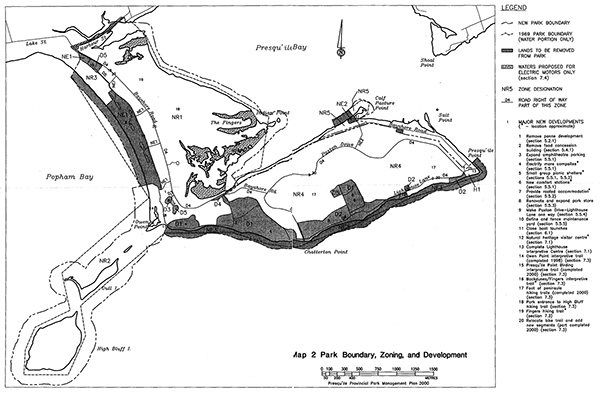
Enlarge Map 2 - Park Boundary, Zoning, and Development.
5.4 Natural environment zones
Natural environment zones include natural, cultural, and aesthetic landscapes in which minimum development is required to support low-intensity recreational activities. The park’s three natural environment zones include 11% of the total park area.
5.4.1 Zone NE1 - Beach-Foredunes (49 ha)
This zone includes the 1.2 km of sand beach that is currently managed, the foredunes behind it, and beach parking and access roads. The beach is both an outstanding recreational resource and a highly significant shorebird and water and land bird migration area. The windward foredunes are highly sensitive landforms.
This zone includes the waters of Lake Ontario within 100 m of shore, including the waters off Zone NR3.
In this plan, "beach managed for recreation" means:
- the entire length of beach in Zone NE1
- from the water’s edge to about 10 m in front of the dunes
- for Beach 4 (the southernmost 200 m of the beach), from June 8 to August 15, and for the rest of the beach, from June 8 to Labour Day (the "management seasons")
On the beach managed for recreation, algae, fish, litter, etc. and associated sand will be raked and the raked material removed, daily or as needed to maintain optimal recreational conditions during the management seasons.
A central objective of the Zone NE1 resource management plan will be to optimize conditions for migrating birds, while seeking to maintain quality beach recreation opportunities in the times and places where those opportunities are most in demand. Along with the policies in Section 6 and the principles listed in Section 5.1, specific principles to be adhered to in preparing this zone resource management plan will include the following.
- The park’s current commitment to foredune protection and revegetation will be continued
- Disturbance to shorebirds will be minimized
- Natural processes will be used wherever possible
- Experimentation with various management approaches and techniques will be encouraged, and their effects monitored
- One experimental approach may be to restrict access to limited parts of the beach for limited times, where and when critical to bird Another may be to erect snow fences at points where they would promote sand deposition
- The beach managed for recreation will be fully open to the public year round, except for:
- emergency closures (see note at end of Table 1)
- access restrictions as described above, outside the management seasons only
- The focus on a high standard of management of the beach managed for recreation during the management seasons should not prevent more limited management actions from being undertaken as needed during the rest of the year
Zone NE1 will remain one of the park’s two main day use areas and will be managed accordingly. Minimal food services may be provided from mobile vending units located in the parking lots and/or by vending carts which may be located and used on the beach during daytime hours only. Services will continue to be provided from the existing food concession building until mobile facilities are in place, at which point the building will be removed.
5.4.2 Zone NE2 - Calf Pasture Cove (4 ha)
This zone includes a low intensity day use area and associated access and parking. Zone NE2 is also part of a very highly significant water and land bird migration area.
This zone includes the waters of Presqu'ile Bay within 100 m of shore, including adjacent waters off Zone NR5.
Although the Calf Pasture Cove boat launch will be closed, this area will remain important as a secondary day use area and the park’s only recreational area on Presqu'ile Bay.
5.4.3 Zone NE3 - South Shore (52 ha)
This zone consists of:
- the waters of Lake Ontario within 100 m of shore in front of Zones 01, 02, H1, and NR4 from High Bluff Campground to Presqu'ile Point
- the shorelands in front of Zones 01 and 02 up to 10 m inland from the ordinary water mark, excepting existing car campground areas less than 10 m inland, which will remain part of Zone D1
The limestone bluffs and gravel and cobble beaches that form most of the south shoreline are subject to erosion and deposition. The shore includes representative sites for landform interpretation and is a significant shorebird and water and land bird migration area. It also provides outstanding vistas over and low intensity access to Lake Ontario.
Existing higher intensity development that is more appropriate to development zones and that extends into the Zone NE3 shoreline strip (intensive day use facilities and the Lighthouse Lane heritage cottages) will be permitted as a continuing nonconforming use. This development will be allowed to remain and may be repaired, restored, or adapted for appropriate reuse, but may not be expanded, enlarged, or replaced.
5.5 Development zones
Development zones provide access to the park, and facilities and services for more intensive day use and car camping activities. The park’s five development zones include 9% of the total park area.
There are no Lake Ontario or Presqu'ile Bay waters in the park’s development zones.
5.5.1 Zone D1-Campgrounds (49 ha)
This zone includes the car campgrounds and group camping area, the campground access roads, and shorelands in front of the car campgrounds up to the Zone NE3 shoreline strip.
There are 394 regular campsites. There are also 10 group campsites in the group camping area, which can accommodate a maximum of 750 campers. (The Background Information/Issues and Alternatives document referred to a maximum of 400 campers; this was an error.) The numbers of regular and group campsites and the capacity of the group camping area will not be increased. However, the following improvements will be made, with the particular objective of improving the campgrounds' suitability and attractiveness for spring, fall, and winter use.
- Parking at the amphitheatre will be expanded
- 108 campsites will be electrified, raising total sites with electricity to Sites selected for electrification will be those that are most likely to be attractive to spring, fall, and winter campers and where the work can be done with the least disturbance to the park environment. There will be no electrification in areas of mature native forest in Craigs, Hidden Valley, Lakeside, and Maples campgrounds
- Small group picnic shelters will be installed in the group camping area
- New comfort stations with showers will be developed in Trail’s End campground .and the group camping area
Ontario Parks will seek to remove or reduce the size of the woodyard east of High Bluff campground, while ensuring good customer service.
Wet conditions in portions of Zone D1 provide amphibian and reptile habitat and affect some campsites. The Zone D1 resource management plan will seek to minimize habitat disturbance and optimize campsite quality by rehabilitating and/or seasonally restricting use of campsites as needed.
5.5.2 Zone D2 - Lighthouse Lane Day Use (19 ha)
This zone includes the Lighthouse Lane day use area on both sides of Lighthouse Lane, the four heritage cottages and adjacent lands south of Lighthouse Lane, and associated parking, except for the Zone NE3 shoreline strip. This is one of the park’s two main day use areas.
The general level of development will not be significantly increased. However, in the day use area, facilities will be upgraded as required and small group picnic shelters will be installed. South and east of the group camping area, day use development will be low intensity in character and restricted in extent.
The cottages may be used for heritage education, visitor information and service, and park research and management support purposes consistent with a heritage buildings management plan for the park (see Section 6.6).
The cottages also present an opportunity for providing roofed accommodation for visitors, consistent with a new initiative of Ontario Parks to diversify its accommodation options. The heritage buildings management plan will determine which cottages and sites are most appropriate for this purpose, and ensure that their cultural heritage values are perpetuated.
Zone D2 includes native forest stands south of Lighthouse Lane. The Zone D2 resource management plan will seek to maintain and enhance this shoreline forest.
5.5.3 Zone D3 - Park Store (0.7 ha)
This zone includes the park store and associated access, parking, and services.
The store will be renovated and expanded, so that it can provide a basic, efficient level of service consistent with current visitor expectations, and maintain or increase revenues to Ontario Parks. The total footprint occupied by the store and its outbuildings will not increase by more than 50 m2. The new services to be provided will be:
- indoor seating for fast food buyers
- washrooms accessible from both inside and outside, including from outside when the store is closed
- access for the disabled
- Ontario Parks gift shop
Picnic facilities may be developed around the store as required.
5.5.4 Zone D4 - Main Roads (1 6 ha)
This zone includes Bayshore Road within the park, Paxton Drive, and Lighthouse Lane. It consists of a 15 m road right of way, which may be widened as required to include traffic islands and junctions.
Roads will be maintained to provincial parks operating standards for hard surfaced main interior roads, and wit occupy only as much of the right of way as required to meet those standards. The Paxton Drive-Lighthouse Lane loop will be made one way for motor vehicles, counterclockwise, year round, and the rest of the existing road surface will be made available for trail purposes (see Section 7.3).
5.5.5 Zone D5 - Operations Areas (4 ha)
This zone includes:
- the park office and maintenance yard and associated access and parking
- the pump house and associated access
- an area to be developed as a native plant nursery for park management and restoration purposes
Except for development of the nursery, the general level of development will not be increased. A maintenance yard perimeter will be defined and fenced, enclosing the smallest area consistent with efficient and effective park operations. Wood chips will only be stockpiled within this perimeter.
6. Resource management policies
Ontario Parks will manage Presqu'ile Provincial Park in accordance with the policies for natural environment parks as set out in Ontario Provincial Parks:
Planning and Management Policies, and the specific policies of this plan.
6.1 Land and water management
All existing roads in nature reserve and natural environment zones that are not specifically permitted by Table 1 will be closed and permanently blocked to motor vehicles. A::r long as waterfowl hunting is permitted to continue in accordance with Section 6.5, waterfowl hunters holding a daily blind permit for the park will be allowed to use the boat launch site at High Bluff camping area on the day that permit is valid. With that exception, all existing boat launches will be closed. The closed roads and launches will be allowed to deteriorate naturally or their sites will be restored to original conditions, as appropriate.
Sewage from comfort stations and in building washrooms in Zones NE1, D1, D2, D3, and D5 will continue to be disposed of in septic tank-tile field systems within those zones. Sewage from vault privies will be removed from the park for disposal.
Waste consisting of natural materials will be reused or composted inside the park where feasible and appropriate. Otherwise, all solid waste will be removed from the park for recycling or disposal. No dams or weirs will be built in the park. Wherever possible, new development or redevelopment will be undertaken so as not to disrupt natural drainage, and zone resource management plans will seek to restore natural drainage where it has been disrupted by past or present development.
6.2 Landform management
Landform management planning will be accomplished through zone resource management plans. Shorelands will be managed in accordance with Presqu'ile Provincial Park Shoreline Resource Management Strategy, 1988, unless and until varied in specific zones by approved zone resource management plans.
6.3 Vegetation management
As indicated in Section 5.2.4, the park is home to a plant species at risk. This species at risk and its habitat, and any others identified in the park in future, will be protected as if they were de$ignated under the Endangered Species Act, and this plan and all zone resource management and other implementation plans must be consistent with this aim. Where active management is required for the recovery of a species at risk, it will be accomplished through zone resource management plans, and in accordance with any national recovery plan for the species developed under the Recovery of Nationally Endangered Wildlife (RENEW) process.
Planted conifers will be removed from Zones NR1 and NE1. In other nature reserve zones, removal will be a long term objective to be addressed through zone resource management plans. In the rest of the park, zone resource management plans will determine whether planted conifers should be removed, thinned, or left alone.
Additional non-native plant species will not be deliberately introduced to the park. (In this plan, "non-native species" means species not native to Ontario as well as species native to Ontario but not to the park.) If established non-native plant species threaten natural heritage values, a program for their eradication will be developed, subject to specific policies elsewhere in this section of the plan. Missing native species may be re established if biologically feasible and acceptable, using seed stocks native to the park or area if possible.
Vegetation may be mowed only:
- along the park boundary, where mowing would assist in clearer boundary identification
- in Zone 04, as required to maintain road safety
- in other development zones, only to the extent necessary to minimize interference with intensive recreational use
Trees and brush may be cut or pruned only:
- to enable resource management or facility development specifically authorized by this plan or by an approved zone resource management or other implementation plan
- to ensure public safety
- in the Hydro One Networks Inc. easement, subject to the guidelines in Section 8
Trees may not be cut for the purpose of providing firewood. Trees and brush cut in nature reserve and natural environment zones outside of conifer plantations will be left to deteriorate naturally as close as possible to where they have been felled. Trees and brush cut in conifer plantations and historical and development zones will be left to deteriorate naturally as close as possible to where they have been felled, or if that is not feasible, may be used for firewood or wood chips in the park.
Native insects and diseases affecting vegetation will be allowed to progress naturally, except where they threaten significant natural heritage values in nature reserve, historical, or natural environment zones, or significant aesthetic values in development zones, in which cases they will be controlled where feasible. Nonnative insects and diseases will be controlled where feasible. Where control is undertaken, it will be directed as narrowly as possible to the specific insect or disease so as to have minimal effects on the rest of the park’s environment. Biological controls will be used whenever possible.
Fires in the park will be suppressed. Suppression techniques that have the least residual impact on the park’s environment will be used wherever practical. This policy does not apply to fires in fireplaces as permitted by regulation under the Provincial Parks Act.
Chemical fertilizers will not be used in the park. Chemical herbicides, pesticides, and suppressants will not be used for any vegetation management purpose except:
- insect and disease control and fire suppression under the conditions set out in this section of the plan
- eradication of non-native species, where it has been demonstrated that other methods with less residual impact on the park’s environment are not feasible
- control of poison ivy in development zones
Vegetation management planning will be accomplished through zone resource management plans.
6.4 Fisheries management
The fisheries of Presqu'ile Bay and Lake Ontario within the park will be managed in accordance with the policies prevailing for those waters. Wherever possible, fisheries management will seek to maintain and enhance native, self-sustaining fish populations. Policies in Section 6.5 on the introduction, replenishment, and eradication of animal species will not apply to the fisheries of Presqu'ile Bay and Lake Ontario.
Angling in Presqu'ile Bay and Lake Ontario will continue to be subject to the regulations prevailing in Sport Fishing Division 8, which includes these waters. Waters within nature reserve zones may be closed to angling temporarily or permanently for fisheries or wildlife research or management purposes.
During the management planning process, the concern was raised that commercial fishing in Presqu'ile Bay and Lake Ontario might be affecting park birds. There is not yet enough information available to determine to what extent this concern is justified, or identify the range of alternatives that might be available to reduce any such impacts without unduly affecting commercial fishers. As part of the implementation of this plan, MNR will seek to obtain the needed information and resolve this issue.
6.5 Wildlife management
As indicated in Section 5.2, the park is or could once again be home to eight bird species at risk. Several other bird species at risk regularly migrate through the park. The park is also significant to the migration of the monarch butterfly, another species at risk. These species at risk and their habitats, and any others identified in the park in future, will be protected as if they were regulated under the Endangered Species Act, and this plan and all zone resource management and other implementation plans must be consistent with this aim. Where active management is required for the recovery of a species at risk, it will be accomplished through zone resource management plans, and in accordance with any national recovery plan for the species developed under the Recovery of Nationally Endangered Wildlife (RENEW) process.
Additional non-native animal species will not be deliberately introduced to the park. If already established non-native species threaten park values, a program for their eradication may be developed if feasible and practical. Missing native species may be reintroduced, and existing populations replenished, if biologically feasible and acceptable, and desirable in terms of perpetuating park values.
Animal populations, including invasive domestic animals, may be controlled when essential to protect human health and safety, natural heritage values, or the health of species outside the park. Conflicts that have arisen between visitors and healthy native animals mainly due to visitor behaviour such as feeding and littering will not be considered as endangering human health and safety. These conflicts will normally be dealt with through visitor education rather than animal control. When animal control is necessary, techniques will be used that have minimal effects on the rest of the park’s environment. Any hunting, trapping, or other control measures will be carried out directly by, or under the supervision of, Ontario Parks.
Ontario Parks will obtain authorization from the Canadian Wildlife Service before undertaking any control or eradication of migratory bird species.
The deer population will be reduced to, and then maintained at, a level that is within the carrying capacity of the park’s deer habitat and sustainable in the context of the park environment. Ontario Parks will set a target population that represents its best scientific judgement as to how many deer the habitat can sustainably support. The target population is estimated to be 35 as of 2000, but will be subject to change from time to time on the basis of new information or habitat changes. The population will first be reduced as quickly as possible to near the target, and then maintained as required to keep it near the target.
Deer population reduction will be undertaken directly by Ontario Parks, or through partnerships under the supervision of Ontario Parks. Reduction will be by shooting.
The park superintendent may close the park to the general public during deer population reduction. Presqu'ile Peninsula landowners and their visitors will continue to be able to drive across the park during any such closure. Special precautions will be taken to ensure public safety when reduction is undertaken near the Presqu'ile Peninsula residential area or Bayshore Road through the park.
A cormorant management strategy will be developed for the park, within the framework of:
- MNR's 1998 policy statement that control may be considered if cormorants are having significant adverse ecological impacts on specific habitats or other species, and
- MNR's 2000 announcement of a five year cormorant research, monitoring, and experimental control program, focusing on the park area and several other locations
This strategy will deal with cormorant impacts on specific park values (vegetation, terrestrial habitat, other bird species). This strategy may be developed as part of the Zone NR2 resource management plan.
Waterfowl hunting, and the launching of boats and use of blinds for that purpose, are permitted to continue until up to five years after alternative waterfowl hunting opportunities have been established outside the park, at which time hunting in the park will be ended without amending this plan. Under no circumstances will the duration or the extent of the hunt be increased.
Those portions of Zones NR1 and NR5 that are outside the 1969 park boundary are currently licensed to trappers. Trapping by persons who were licensed on January 1, 1989 will be allowed to continue until:
- they surrender their licences
- their licences are revokedfor cause, or
- January 1, 2010
whichever is sooner. Status Indians are exempted from this phaseout.
Wildlife management planning specific to individual habitat issues (for example, shorebird migration in Zone NE1) will be accomplished through zone resource management plans. Ontario Parks will prepare a wildlife management plan for the park as a whole, to address issues of general application (for example, control of invasive domestic animals).
6.6 Cultural heritage management
Significant cultural features will be protected from incompatible development wherever they occur in the park. Incompatible resource uses and recreational activities will be restricted or prohibited where necessary to protect significant cultural heritage values. Archaeological and historical artifacts may only be removed and heritage landscapes altered as part of approved cultural heritage research or management projects.
Ontario Parks will prepare a heritage buildings management plan for the four heritage cottages along Lighthouse Lane. The plan will:
- assess the significance of each building and its immediately surrounding cultural landscape, and the structural condition of each building
- prescribe the kinds of interpretive uses and/or adaptive reuses appropriate to each building, within the range of uses permitted in Zone D2
- indicate any conservation or restoration required to perpetuate each building’s cultural heritage value and permit appropriate uses consistent with public safety
- indicate the ranges of structural and use changes permitted to each building without an amendment to the heritage buildings management plan
- provide guidelines as to appropriate non-structural maintenance (painting, landscaping, etc..
Although an archaeological survey of the park was carried out in 1972, further study is required and will be encouraged. Management strategies for any archaeological sites found in the future may range from allowing the sites to evolve without human interference, to research, excavation, and rehabilitation. Protection and management will be undertaken in consultation with the Ministry of Citizenship, Culture and Recreation and Mohawks of the Bay of Quinte.
7. Park operations policies
Presqu'ile Provincial Park’s operating plan will continue to provide Ontario Parks staff with the information required to operate the park on a day-to-day basis. The plan will provide specific direction for the management and operation of all park facilities and activities. In addition to the policies that follow, the plan will address such topics as budgets, staffing, maintenance, enforcement, and emergency services. The park operating plan will be consistent with this plan and the Ontario Provincial Parks Operating Standards, and will be reviewed annually and updated as required.
To ensure that park operations continue to meet the standards of the park operating plan, self-serve facilities may be developed, and individual volunteers and partner organizations (see Section 9.3) may be involved in park programs. Ontario Parks has the right to suspend operations of any facilities or services due to funding limitations, but in so doing will ensure that heritage values are not impaired and customer service standards are affected as little as possible.
Various new business practices may be introduced into park operations in accordance with the mandate of Ontario Parks. These will include:
- improving operating efficiency and controlling costs
- contracting out some operating functions
- improving customer service standards
Ontario Parks staff may use motorboats and motor vehicles in the park to the extent necessary for efficient park management and operations. In approving research applications (see Section 7.2), Ontario Parks may authorize researchers to use motorboats and motor vehicles to the extent necessary for research to be conducted safely and efficiently. Both Ontario Parks staff and approved researchers will conform wherever possible to the limitations applicable to recreational users. Any other public agency may use any craft or vehicle for emergency rescues in the park, subject to the approval of the park superintendent.
7.1 Heritage education
Heritage education in provincial parks is intended to develop visitors' awareness and appreciation of Ontario’s natural and cultural heritage, fostering a commitment to protecting that heritage for all generations. Heritage education opportunities are meant to be educational and recreational, formal and informal, and accessible to all. There are three components of heritage education in parks: information, interpretation, and outdoor recreation. The level of service each park provides depends on its significance and visitation. At Presqu'ile, heritage education is at the major activity level, the highest available.
The 1991 Visitor Services Management Plan (now referred to as a natural heritage education operating plan) will continue to guide the park’s information and communications services and interpretive and recreational programs. It will be reviewed annually and updated as required. The park will continue to offer:
- a comprehensive, high quality information system
- a full range of interpretive and educational programs and opportunities, from unstructured individual exploration to organized programs directed to a variety of audiences
- appropriate outdoor recreation skills programs
As prescribed by the natural heritage education operating plan, the principal themes of park interpretation are evolution of life in the Ordovician era, development of the tombolo, ecology of the marsh, ecology of Lake Ontario, biodiversity of the park, bird migration, monarch butterfly migration, and marine history.
With the implementation of this park management plan, increased emphasis will be given to:
- interpreting the park’s cultural heritage, including its marine, settlement; recreational, and Aboriginal heritage
- interpreting the implementation of the natural heritage management policies of this plan and the zone resource management and other implementation plans
- better promoting park programs and services in the Brighton area, and increasing community involvement
- providing more services in spring, fall, and winter
- providing more and better services to school groups
A natural heritage visitor centre will be developed in one of the Lighthouse Lane heritage cottages. The heritage buildings management plan described in Section 6.6 will determine which cottage and site are most appropriate for this purpose, and ensure that their cultural heritage values are perpetuated.
The new portion of the Lighthouse Interpretive Centre will be completed as a cultural heritage visitor centre. The lightkeeper’s home will be a special exhibition area.
In addition to the specific developments authorized by this plan, and subject to the possibility that in nature reserve zones, public access may need to be limited as described in Table 1, viewing decks or blinds and outdoor display panels may be installed along trails or elsewhere at heritage sites of particular interest.
7.2 Research
Research by qualified individuals that contributes to knowledge of natural and cultural history and to environmental and recreational management will be encouraged.
All research projects will require the written authorization of the park superintendent, and must be consistent with provincial parks research policies and all applicable legislation. Research activities will also conform with Ontario Parks, A Research and Information Strategy, 1997, as it relates to current science, research, and information needs, as well as Ontario Parks priorities. Sites altered by research activities will be rehabilitated as closely as possible to their previous conditions.
The following general fields of research are particularly appropriate to Presqu'ile Park and will be encouraged:
- landforms, vegetation, wildlife, and archaeology of the park
- evolution of the park’s landscapes in relation to natural processes and human activity,
- ecological restoration and management in the park
- the status of species at risk and other rare species and communities
- optimal relationships between heritage protection and recreational enjoyment within the park
Ontario Parks will evaluate and decide upon each application to conduct research using the following criteria, in addition to the research policies and strategies for provincial parks and the policies in this section of the plan:
- the subject matter of the research relative to the above priorities, and whether the proposed research complements existing research work and data
- whether the park is a particularly suitable environment for the research, versus whether the research could be equally well conducted elsewhere
- the methodology to be followed and the sensitivity of the resources to be investigated
- for research on the islands, the researcher’s skills and preparedness for safe boating and camping without support from Ontario Parks
- the researcher’s qualifications and experience, and past record, if any, in Presqu'ile or other provincial parks
As indicated in Section 5.5.2, the heritage cottages in Zone D2 may be considered for research support uses consistent with the heritage buildings management plan.
7.3 Trails
There will be four types of trails in the park. Trail developments since the 1996 Background Information/Issues and Alternatives document are indicated below. Recently completed trails will be formally named, as will new trails as they are developed. Trail development policies and standards are discussed in Section 8.
Interpretive trails
- Marsh Boardwalk (existing)
- Jobes' Woods Trail (existing; new trail entrance has been located)
- Owen Point Trail (Beach 4 to Owen Point) (existing; completed 1998)
- Presqu'ile Point Birding Trail (existing; completed 2000)
- New trail in backdunes and Fingers (not yet located)
Hiking trails
- Two trails in foot of peninsula (former Newcastle and other trails; completed 2000).
- Park entrance to High Bluff campground trail (to be marked within the following existing alignments):
- park entrance to Beach 1 parking - within Bayshore Road and Beach 1 access road rights of way
- Beach 1 parking to Beach 4 parking - on trail formerly used for cycling
- Beach 4 parking to High Bluff campground - alongside bike trail
- New trail in Fingers, subject to determination that it can be developed without impairing park values (not yet located, will complement backdunes/Fingers interpretive trail)
Bike trail
- Park entrance to Beach 4 parking - within Bayshore Road and Beach 4 access road rights of way (completed 2000)
- Beach 4 parking to Chatterton Point (existing)
- Paxton Drive-Lighthouse Lane loop - on part of existing road surface to be made available by instituting one way traffic (to be completed)
Birding footpaths
- Existing unmarked paths and new paths (not yet located)
Cross-country skiing will be permitted on all appropriate trails, but trails will not normally be managed for skiing.
Cycling will not be permitted on the interpretive trails, hiking trails, and birding footpaths.
7.4 Recreation management
Entry to the park will be controlled year round and day use and camping fees will be collected from all park visitors.
Bayshore Road across the park will continue to be free and open to Presqu'ile Peninsula landowners and their visitors who are not otherwise using the park. Landowner access will only be limited in case of emergency closure as described in the note at the end of Table 1.
Consistent with day use parking spaces being limited as described in Section 8, not more than 1,275 vehicles holding day use permits will be permitted in the park at one time.
The following recreational activities will not be permitted in the park:
- snowmobiling
- all-terrain vehicle use
- aircraft takeoff and landing
- horseback riding
Park values potentially affected by boating activities include bird nesting habitat and migration areas along the shorelines of Zones NR1, NR2, and NR5 and in the inlets of Zone NR1, and black tern nesting habitat on the open waters of Zone NR1. As described in Table 1, federal regulations already limit motorboat speeds within 30 m of shore. Ontario Parks .will seek new regulations to prohibit motorboating, except using electric motors, in the inlets of Zone NR1 as shown on Map 2, and to prohibit all motorboating in Zone NR2.
Ontario Parks will encourage compliance with present and future boating regulations through signage and other communications, visitor education, and increased enforcement. Ontario Parks will carefully monitor boating impacts on the park values of concern. If the approach described here does not adequately protect those values, Ontario Parks may seek to further restrict boating within Zones NR1 and NR5.
7.5 Tourism services
The following tourism services may be developed and operated either through concession agreements or by Ontario Parks directly:
- the park store as permitted by this plan
- food services permitted by this plan
- rental of recreational equipment whose use is permitted in the park
- public transit on park roads
7.6 Marketing
A marketing plan will be prepared for the park consistent with the overall marketing strategy of Ontario Parks. The plan will develop strategies for:
- promoting the park on the basis of its natural and cultural heritage values and recreational opportunities, and appropriate enjoyment and appreciation of those values and opportunities
- promoting year-round use
8. Development policies
There are approximately 1,275 day use parking spaces in Presqu'ile Provincial Park (1,200 in Zones NE1 and D2, with the rest in Zones H1 and NE2 and at trailheads in Zones NR1 and NR4). Despite any other provision of this plan, the total number of day use parking spaces in the park will not be increased beyond 1,275. As Zone D1 is for camper use only, parking spaces in that zone will not be considered to be day use parking spaces.
All development undertaken by Ontario Parks, or by concessionaires on its behalf as permitted by Section 7.5, will be carried out in accordance with approved site and development plans that meet development standards for provincial parks. The location, design, and materials of all facilities will as much as possible reflect the natural environment character of the park. Durable, low maintenance, and energy efficient designs and materials will be used wherever possible.
New trails or trail segments and associated viewing decks or blinds will be built to standards appropriate to their trail type. For those trails indicated in Section 7.3 as "not yet located", proposed locations and standards will be made available for public review and comment before the trails are built.
Any restoration or reconstruction of cultural heritage features will conform to high standards of cultural authenticity and will complement, not interfere with, the features themselves.
Any new utility lines required by Ontario Parks will be built within rights of way of open roads wherever possible.
Ontario Parks will seek to ensure that any alterations by Hydro One Networks Inc. to its easement and the transmission lines within it, and by the Government of Canada to Presqu'ile Lighthouse and the High Bluff Island beacon, reflect as much as possible the natural environment character of the park and, as discussed in Section 4.2, the lighthouse’s cultural value.
Map 2 shows the specific major new developments authorized by this plan. The legend provides references to the section of this plan in which the developments are more fully described. Within the limits established by this plan, the final location and extent of all development will be determined through site and development planning processes.
9. Plan implementation
9.1 Implementation priorities
Ontario Parks will give priority to completing the following major initiatives, as funds permit. These initiatives are listed in order of their appearance in this plan, not in any order of rank. Except where indicated otherwise in this plan, or as required under the Environmental Assessment Act, no further public consultation will be required for these developments to proceed.
In order to manage the park effectively, Ontario Parks will prepare various implementation plans. These will include those listed among the initiatives that follow, as well as site and development plans as described in Section 8. A natural heritage education operating plan and a park operating plan are already in place. Zone resource management plans and the heritage buildings management plan will be made available for public review and comment in advance of approval or amendment.
Resource Protection and Management
- support international conservation designations (Section 3.4)
- prepare zone resource management plans (Sections 5.1-5.5)
- remove panne development, Zone NR1 (Section 5.2.1)
- remove food concession building, Zone NE1 (Section 5.4.1)
- define and fence maintenance yard perimeter, Zone 05 (Section 5.5.5)
- close and block roads, NR and NE zones (Section 6.1)
- close boat launches (Section 6.1)
- remove planted conifers, Zones NR1 and NE1 (Section 6.3)
- obtain more information on and resolve concerns about commercial fishing impacts (Section 6.4)
- start deer population reduction (Section 6.5)
- prepare cormorant management strategy (Section 6.5)
- prepare wildlife management plan (Section 6.5)
- prepare heritage buildings management plan (Section 6.6)
- end cycling on trails in panne (Section 7.3)
User Facilites and Services
- install mobile vending facilities, Zone NE1 (Section 5.4.1)
- expand amphitheatre parking, Zone (Section 5.5.1)
- electrify more campsites, Zone 01 (Section 5.5.1)
- install small group picnic shelters, Zone 01 (Section 5.5.1)
- develop new comfort stations, Zone (Section 5.1)
- install small group picnic shelters, Zone 02 (Section 5.5.2)
- provide roofed accommodation for visitors consistent with heritage buildings management plan, Zone 02 (Section 5.5.2)
- renovate and expand park store, Zone (Section 5.5.3)
- make Paxton Drive-Lighthouse Lane one way for motor vehicles, Zone 04 (Section 5.5.4)
- develop natural heritage visitor centre consistent with heritage buildings management plan, Zone 02 (Section 7.1)
- complete Lighthouse Interpretive Centre, Zone H1 (Section 7.1)
- develop backdunes/Fingers interpretive trail, Zone NR1 (Section 7.3)
- mark park entrance to High Bluff Campground hiking trail, Zones 04, NE1, NR1/NR2 (Section 7.3)
- develop Fingers hiking trail, Zone NR1 (Section 7.3)
- develop new bike trial segments, Zones NE1, 04 (Section 7.3)
Administration
- revise and resurvey boundary (Section 4.1)
- prepare marketing plan (Section 7.6)
- pursue community liaison and establish Presqu'ile Forum (Section 9.2)
All undertakings in provincial parks are subject to, and will be carried out in accordance with, Ontario’s Environmental Assessment Act.
9.2 Community involvement in plan implementation
The park superintendent will establish and chair a Presqu'ile Forum, to continue and formalize existing liaisons among the park, the community, and individuals and groups that value the park’s heritage.
The Presqu'ile Forum will allow for the exchange of information and perspectives, and provide advice and assistance to the superintendent, on:
- planning, economic, tourism, and recreational matters of mutual park and community interest,
- implementation of the management plan, particularly as it affects the park’s natural and cultural heritage and recreational opportunities.
The park superintendent will:
- invite the following to appoint representatives to the Forum:
- Municipality of Brighton
- Mohawks of the Bay of Ouinte
- Friends of Presqu'ile Park
- Presqu'ile Point Property Owners' Association
- Federation of Ontario Naturalists and/or Presqu'ile Brighton Naturalists
- Ontario Federation of Anglers and Hunters and/or local anglers and hunters
- such other organizations as the superintendent considers appropriate
- appoint to the Forum individuals who collectively represent a broad range of expertise and perspectives on the park’s heritage
The park superintendent may also establish liaison groups independent of the Forum, to provide advice and assistance for a limited time on a specific issue or task.
9.3 Partnerships
Ontario Parks will continue to encourage and assist the growth and development of the Friends of Presqu'ile Park, an important partner in implementing this plan. Ontario Parks will continue its existing partnerships with the Friends and explore new ones.
Partnerships will also be explored with Mohawks of the Bay of Quinte, other agencies, community and interest groups, and the private sector. These partnerships will be essential to the achievement of the park’s protection, heritage appreciation, and tourism objectives.
Existing partnerships to be continued include:
- producing interpretive and educational materials (Friends of Presqu'ile Park)
- employing student interpreters and researchers (Friends)
- staging special events (Friends)
- improving resource management (Friends, Presqu'ile Brighton Naturalists)
- developing interpretive trails (Friends, Presqu'ile Brighton Naturalists)
- operating the Friends of Presqu'ile Nature Shop in the Lighthouse Interpretive Centre (Friends)
Future partnership areas that Ontario Parks will explore include:
- increasing naturalist involvement in natural heritage inventory, research, and management, including monitoring of species at risk
- increasing community involvement in heritage education
- working with municipalities to facilitate appropriate use of road allowances adjacent to the park for birding
- developing corporate sponsorships of exhibits, programs, and special events
Ontario Parks is also willing to enter into a planning partnership with area municipalities for the development and promotion of the Presqu'ile-Brighton area as a primary tourism and recreation area, building on and sensitive to the values of the park.
10. Plan review and amendment
After its approval, this Management Plan may be reviewed as required at any time during its 20 year term, to confirm or revise its policies, or to address new issues or changing conditions. A review will require full public consultation.
In the interim, the plan may be amended as needed.
- A major amendment would involve any change that would represent a marked departure from the plan’s original intent and Such changes could have significant impacts on the park’s environment, affect users of adjacent lands, or result in significant public reaction. Major amendments will require full public consultation.
- A minor amendment would involve administrative or housekeeping changes that would not alter the plan’s intent, affect the park’s objectives or its ability to meet those objectives, or have any significant impacts on the park’s environment or Public notice will be given of a minor amendment. Ontario Parks will determine what, if any, public consultation is needed prior to approval
Anyone may initiate an amendment process by submitting a proposed amendment, with an explanation of its purpose, to Ontario Parks, which will determine whether and under what conditions the amendment process should proceed.
11. Key references
All documents were prepared by and for MNR except as noted, and are available for inspection at the Presqu'ile Provincial Park office. Copies of the asterisked documents are available without charge on request from Ontario Parks, 51 Heakes Lane, Kingston, Ontario K7M 9B1, (613) 531-5724.
Documents published or copublished by the Friends of Presqu'ile Park may be purchased at the park office or from the Friends of Presqu'ile Park, Box 1442, Brighton, Ontario K0K 1H0, (613) 475-2204.
Ministry of Natural Resources Statement of Environmental Values, 1995.
Beyond 2000, 2000.
Ontario Provincial Parks: Planning and Management Policies, 1992.
Ontario Provincial Park Management Planning Manual, 1994.
Ontario Parks, A Research and Information Strategy. Part One: Setting Priorities, 1997.
Index List of Vulnerable, Threatened, Endangered, Extirpated or Extinct Species of Ontario, regularly revised.
The Geomorphology of Presqu'ile Provincial Park, by Jane Law, 1989.
Presqu'ile Provincial Park Vegetation, by Cathy Keddy, 1989.
Presqu'ile Provincial Park Wildlife Update, by Steve LaForest, 1989.
Birds of Presqu'ile Provincial Park, by Steve LaForest for the Friends of Presqu'ile Park and MNR, 1993.
A History of Presqu'ile, by Commonwealth Historic Resource Management Limited, 1989. All except resource evaluation and recommendations revised and republished as A History of Presqu'ile, by Larry Turner for the Friends of Presqu'ile Park, 1992.
Presqu'ile Master Plan [for lighthouse area only], by Canadian Cultural Resource Consultants and Christopher Borgal Architects Inc., 1993.
Presqu'ile Provincial Park Shoreline Resource Management Strategy, draft, 1988.
Presqu'ile Provincial Park Visitor Services Management Plan, 1991.
Presqu'ile Provincial Park Management Planning Background Report, 1995.
Presqu'ile Provincial Park: Background Information/Issues and Alternatives, by Anthony Usher Planning Consultant, 1996.
Background Information/Issues and Alternatives: Summary of Public Response, by Anthony Usher Planning Consultant, 1996.
Presqu'ile Provincial Park: Preliminary Management Plan, by Anthony Usher Planning Consultant, 1999.
Preliminary Management Plan: Summary of Public Meeting-Brighton, March 25, 1999, by Anthony Usher Planning Consultant, 1999.
Preliminary Management Plan: Summary of Pubnc Response, by Anthony Usher Planning Consultant, 2000.
Management Plan: Ontario Parks Position on Major Issues, by Anthony Usher Planning Consultant, 2000.
Note to file for: Presqu'ile Provincial Park Management Plan, 2000
1.0 Clarification of permitted uses and development – Zone NE1
With respect to intensive day use facilities, note 15 to Table 1 on page 12 of the management plan is clarified as:
- change houses, comfort stations, temporary picnic shelters and associated utilities only
This reflects the use and development within Zone NE1 – Beach-Foredunes at the time of approval of the management plan, and is in keeping with the intent of this zone. There are utilities associated with facilities such as comfort stations (e.g. hydro, water and sewage). The water and sewage system was being replaced at the time of preparation of this note to file.
The approved note to file will be filed at the Ontario Parks, South Eastern Zone office. Copies will be distributed to Presqu'ile Provincial Park and Ontario Parks, Planning and Research Section in Peterborough.
John M. Immerseel, Zone Manager
Ontario Parks, South Eastern Zone
Kingston, ON