Puzzle Lake Provincial Park Management Statement
This document provides policy direction for the protection, development and management of Puzzle Lake Provincial Park and its resources.
Interim Management Statement
2001
Zone manager’s approval statement
I am pleased to approve this Interim Management Statement for Puzzle Lake Provincial Park. This Natural Environment Park supports a wide diversity of habitats and species, while providing excellent opportunities for low-impact recreation.
This Interim Management Statement will provide interim direction for the management of the newly created Puzzle Lake Provincial Park until a comprehensive Management Plan is prepared. This document will provide the basis for future management planning.
Signed by:
John M. Immerseel
Manager, South Eastern Zone
Ontario Parks
Kingston, ON
1.0 Background
Puzzle Lake Provincial Park is one of many new protected areas proposed through the Lands for Life planning process. The culmination of the Lands for Life process was the development of Ontario’s Living Legacy Land Use Strategy (OLL-LUS) (OMNR 1999). The Puzzle Lake site was identified to be regulated as a Natural Environment class provincial park in the OLL-LUS; as a result, it was regulated under the Provincial Parks Act in April, 2001.
Natural environment parks incorporate outstanding recreational landscapes with representative natural features to provide high quality recreational and educational experiences (OMNR 1992). The Puzzle Lake site was proposed as a Natural Environment Park due to its tremendous variety of habitats and vegetation communities, its high number of provincially rare species, and its excellent recreational opportunities. In the short term, the park will be a non-operating park, with permitted uses including canoeing, hiking, interior camping, fishing, and hunting.
This IMS is intended to guide the custodial management of the park until an approved Park Management Plan is in place. The IMS guidelines place a priority on the protection of the natural heritage values of Puzzle Lake Provincial Park, while accommodating some existing uses. The policies in this IMS are consistent with those for Natural Environment class parks published in Ontario Provincial Parks: Planning and Management Policies (1992), as well as the amendments made in the OLL-LUS (Appendix I).
1.1 Planning issues
Permitted uses within the park will follow the guidelines set out in the OLL-LUS.
The term Puzzle Lake is used in various documents to refer to the protected area, the ANSI, and the lake itself. This document will use the terms Puzzle Lake Provincial Park (PP), Puzzle Lake proposed ANSI, and Puzzle Lake, respectively.
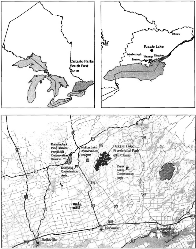
The protected area is immediately east of Mellon Lake Conservation Reserve (8,655 ha.) and Kaladar Jack Pine Barrens Conservation Reserve (1,086 ha. regulated in 1997) (Figure 1). These sites are similar in terms of their representation of rock barrens; in combination with Puzzle Lake they protect almost 13,500 ha. Two Conservation Areas owned by the Quinte Region Conservation Authority are located less than 20 km from Puzzle Lake PP: Sheffield (467.2 ha) and Depot Lakes (1,214.6 ha).
Management guideline:
- Future management planning and research should adopt a greater ecosystem approach, considering management prescriptions that apply to these three provincially protected areas as a complex.
2.0 Site description
Puzzle Lake PP encompasses an area of approximately 3724 ha at the southern edge of the transition between the Precambrian Shield and Lake Ontario Lowlands. Most of the park falls within a larger provincially significant area proposed as the Puzzle Lake Area of Natural and Scientific Interest (ANSI) (Brownell 1997). The rugged and diverse terrain is composed of a mosaic of rock barrens, igneous cliffs, dry-mesic mixed forest, and numerous wetlands and lakes. This Crown land area has been popular with recreational users for decades, and there are well-developed all-terrain vehicle (ATV) and snowmobile trail systems throughout the park, as well as boat caches and hunt camps.
3.0 Location and boundary
The park is located approximately 12 km north of the Town of Tamworth, and 60 km northeast of the city of Kingston via Highway 401 and County Roads 4 and 15 (Figure 1). Puzzle Lake PP lies within the geographic Township of Sheffield, which is now part of the municipal Township of Stone Mills (formerly Sheffield, Camden East, and Newburgh Townships) in Lennox and Addington County. It is located within the Peterborough District of the Ministry of Natural Resources (MNR). The newly regulated park is administered by the South Eastern Zone of Ontario Parks. The park is located in Ecodistrict 5E-11, within the Salmon River watershed.
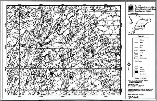
The park is at the southern edge of the OLL planning area and consists of a single large block of Crown land with small pockets of private land (Figure 2). Its boundary is described by Regulation Plan P4 Puzzle Lake Provincial Park (Jan. 4, 2001).
4.0 First nations
This site does not fall within the area of the Algonquin land claim; however, it is close to the general area that the local Sharbot Mishigama Anishabae Aboriginal community assert as being their traditional use area. The site also lies within the Interim Traditional Area of the Mohawks of the Bay of Quinte, as defined in 1994 by the Ministry of Natural Resources.
Management guidelines:
- The creation of this park and its management will not abrogate or derogate from any Aboriginal or treaty rights recognized or affirmed by section 35 of the Constitution Act, 1982.
- Ontario Parks intends to communicate and work with appropriate Aboriginal communities throughout the planning and development of the park.
Figure 1. Regional Context
Enlarge Figure 1. Regional Context
5.0 Land tenure and acquisition
The 3724 ha property is comprised primarily of unpatented Crown land in the geographic Township of Sheffield. The park surrounds two parcels of patented land, neither of which have direct road access: Lot 16, Concession XII, and half Lot 19, Concession XIII. There is also a 1.38 ha parcel of land on Puzzle Lake in Lot 20, Concession XI, which was transferred from the Crown to private landowners in a land exchange agreement in 1984. In return, the Crown received Parts 1, 2, and 3 of Lot 21, Concession XI (Survey Plan 29R-2479). These parcels, totalling 23 ha, are located on Gull Lake and have not yet been included within the regulated boundary.
Management guidelines:
- Ontario Parks will take steps to ensure that the land obtained through the land exchange agreement is included within the park boundaries.
- Should the patented properties within the park boundaries become available by willing vendors Ontario Parks will consider acquisition as funds permit.
- Priority areas for acquisition or other methods of land securement, including easements, agreements, or the Conservation Land Tax Incentive Program (CLTIP), will be identified through analysis of earth and life science values in the area.
6.0 Provincially significant areas and land use designations
The site protects roughly 80% of the lands proposed as the provincially significant Puzzle Lake ANSI (Brownell 1997); the remaining 20% falls on private lands or within the proposed Mellon Lake Conservation Reserve. Puzzle Lake ANSI was proposed due to its diversity of upland and wetland habitats, and its abundance of provincially rare species and plant communities (White 1993, Brownell 1997). The southwestern portion of the park extends beyond the ANSI boundary into an area that has not yet been explored or evaluated from a life sciences perspective. This area is likely to show the same exceptional features as the proposed ANSI.
Puzzle Lake PP is identified as Crown land in the Tweed District Land Use Guidelines (1983). The Official Plan for the Township of Stone Mills states that "lands owned by the Crown are exempt from policies of this Plan and can be developed in accordance with the provisions of other Provincial Acts" (Cumming Cockburn Limited, 2000). Most of the surrounding land is privately owned and is zoned as Rural. There is an active municipal household waste disposal site adjacent to the park (Concessions VIII and IX, lots 16 and 17, Sheffield geographic township).
Management guidelines:
- Ontario Parks will work with other provincial programs, adjacent municipalities, and neighbouring landowners to encourage protection or management of adjacent lands in a manner that complements the protection of the proposed ANSI and the park.
- The municipality will be encouraged to support its staff in protecting the property by reporting any non-conforming activities to Ontario Parks.
7.0 Access, existing and new development
County Road 15 is the primary access route to the area, although it does not provide direct access to the park (Figure 2). There is a parking area and boat access to Gull Lake (Concession X, Lot 21) along County Road 15. From Gull Lake, there is a portage of approximately 50 m within the protected area into Puzzle Lake.
Norway Lake Road is an open, unmaintained road, traditionally used to provide access to Norway Lake and the hunt camps there. A hydro transmission corridor easement runs east-west through the park, bisecting the protected area and providing some access to its interior. There are snowmobile and all-terrain vehicle (ATV) trails associated with Norway Lake Road and the hydro corridor. Guidelines regarding ATV travel are discussed in section 9.0, Recreational Activities.
Management guidelines:
- Signs identifying the park will be erected at all access points
- New developments will not be considered until detailed resource inventories have been completed and an approved Park Management Plan is in place.
- New hydro-electric development will not be permitted within the park.
- The condition and use levels of Norway Lake Road will be determined, and Ontario Parks will assess options for future use through management planning. Ontario Parks will investigate the need for signage warning users of the poor condition of the road.
8.0 Commercial activities
Four existing traplines and one bait fishing licence cover the park area. The OLL-LUS states that existing commercial fur harvesting will be permitted to continue indefinitely in new Natural Environment parks within the OLL planning area. There are no existing Bear Management Area (BMA) licences in the park.
In new provincial parks in the OLL planning area, mineral exploration may occur under controlled conditions in areas of these parks identified as having provincially significant mineral potential (OLL-LUS 1999). Currently, the park area is not considered to have provincially significant mineral potential (Easton 1999), but negotiations with the Ministry of Northern Development and Mines (MNDM) may determine otherwise.
Management guidelines:
- The bait fish licence was allocated while Puzzle Lake Provincial Park was under interim protection through OLL. The lakes contained within the park will be removed from the licence.
- No new commercial fur harvest operations, including cabins or trails, will be permitted.
- No new BMA licences will be permitted.
- Commercial timber harvesting will not be permitted.
- Unless identified by the MNDM as having provincially significant mineral potential, the park will be closed to mineral exploration.
9.0 Recreational features and activities
A reconnaissance-level inventory to assess current uses and potential opportunities for recreation has been completed by Ontario Parks, South Eastern Zone. Interior canoeing and camping occur in the park, along with other recreational uses. Several campsites, consisting of cleared areas and fire pits, are apparent on the shores of Puzzle, Gull, Bear, and Loyst Lakes. There are a half dozen cottages, boat and canoe caches, and docks on the private land on Puzzle Lake. The Puzzle Lake area is also used extensively for sport hunting and fishing, as well as trapping, with associated boating and ATV activity. The impact of ATV travel on trails and the surrounding environment has not been assessed. Under Provincial Park Policy for Natural Environment class parks, ATV use is normally restricted to development and access zones, which are designated during park management planning. A Memorandum of Understanding, which permits use of certain parcels for a snowmobile trail, has been signed with the Lennox and Addington Ridge Runners.
There are land use permits (LUP) for two recreation camps situated on Norway Lake (permit #0314 and #18042) within the park. Both camps have been in existence since 1964 and use Norway Lake Road for access. The LUPs are renewed on an annual basis. One of the camps is accessible only by boat. A cottage is situated on a parcel of private land on Norway Lake and is also accessible by boat.
Management guidelines:
- Ontario Parks staff will routinely monitor the recreational use of the park to ensure use is compatible with restrictions under the Provincial Parks Act.
- Existing backcountry campsites will be identified with markers, and operational requirements will be investigated and addressed. Camping is restricted to existing designated sites. At present, no permit or fee is required to use these campsites.
- Sport hunting and fishing will be permitted to continue throughout the park until management planning is complete. Safety and conservation will be considered with public consultation during management planning.
- In accordance with Ontario Provincial Parks Planning and Management Policies (1992), live bait fish should not be used or possessed in this provincial park. Until such time as a regulation is established, Ontario Parks will discourage the use or possession of bait fish in this park.
- The extent and impact of recreational vehicle traffic will be assessed, and access may be restricted where found to be necessary to maintain park values. In the interim, ATV travel will be restricted to existing trails.
- The use of existing authorized snowmobile trails will be permitted to continue. The Memorandum of Understanding will be updated to ensure its accordance with park policies.
- The two existing recreational camps will be permitted to continue, but the effects of the camps on the ecological and recreational values of the park must be evaluated to determine their long-term suitability. Enhanced tenure may be granted through an environmental screening process. No fuelwood cutting will be permitted inside the park in association with these LUPs.
- The owners of boats cached on Crown land on Puzzle Lake and Loyst Lake will be notified to remove their boats. Boats cached on Norway Lake for the purpose of access to the private cottage or the recreation camp will be permitted to remain until policy direction is determined with public consultation during park management planning.
- Decisions regarding motorboat travel on Puzzle, Loyst, Norway, and MacNeil Lakes will be determined through management planning.
- A user survey and full recreational resource assessment will be completed to accurately assess current use levels, other recreational opportunities, and possible issues.
10.0 Resource inventories
Preliminary earth and life science inventories have been conducted in the Puzzle Lake area by Easton (1999) and Brownell (1997), respectively. A reconnaissance-level earth science inventory was completed in 2000. A summary of background information is attached (Appendix II).
10.1 Earth science features
Puzzle Lake PP lies within the Central Metasedimentary Belt of the Grenville Province of the Precambrian Shield (Easton 1992). The topography of the property is characterized by moderately steep slopes and hills, with 10 m to 15 m high cliffs rimming portions of Puzzle, Norway, Loyst, and Gull lakes. The open areas of exposed rock are a distinctive feature of this area. The surficial geology of the property includes bare rock ridges with shallow glacial till found in the intervening troughs between the bedrock outcropping (Chapman and Putnam 1984, Brownell 1997). The dominant rock types exposed are supracrustal and plutonic rocks of the Mazinaw and Sharbot Terranes, and the Robertson Lake mylonite zone that divides the two terranes (OMNR 2000). The geology of the site has regional significance in its representation of these rock types.
Management guidelines:
- A comprehensive earth science inventory is scheduled for 2001.
10.2 Life science features
A reconnaissance-level biological inventory and evaluation of the Puzzle Lake proposed ANSI was conducted in 1994 and 1995 (Brownell 1997). The wide range of moisture regimes and rock substrates of the area support the greatest abundance of rare communities and species found in an ANSI in eastern and central Ontario. The special features of this site are discussed fully in the Life Science Checksheet (Appendix III).
The most common upland habitat type is Red Oak deciduous treed rock barrens and other mixed oak community types. These community types support a diverse herbaceous plant layer. Five 51-ranked vascular plant species were found in the site (Appendix III); these occurrences represent significant disjunct populations of typically southern species. The Common Juniper - Bear Oak community type that is found along several lakes in the park and surrounding area is unique in Canada, and is one of the few known Canadian populations of Bear Oak (Quercus ilicifolia).
The area also supports rare species of animals, including a nationally vulnerable reptile (Appendix III).
The park areas that fall outside the proposed ANSI boundary have not been evaluated from a life sciences perspective, but are likely to support similar features. Since the only inventory work to date has been at the reconnaissance level, there is high potential for the discovery of additional rare species or other items of conservation interest.
Management guidelines:
- Gaps in the life science inventory of the park will be addressed prior to completion of an approved Park Management Plan. Partners and researchers will be encouraged to provide inventory information that is currently lacking.
- Opportunities for investigation of the bat hibernaculum by experts from the Royal Ontario Museum (ROM) will be explored. Management guidelines will be provided at that time.
- Southcentral Region should ensure that the site is confirmed as an ANSI in order for private lands to be eligible for the CLTIP.
10.3 Cultural resources and traditional land uses
There has been no cultural resource inventory or assessment conducted on the property. Until recently, known human settlement in the area was limited to one private fish camp on Puzzle Lake.
Northern Stone Mills Township was probably covered by primeval forest until about 1850, when lumbering activity began and logs were floated down the Salmon River to the mill in Tamworth (Brownell 1997).
Management guideline:
- Ontario Parks will investigate the park in consultation with the Ontario Ministry of Tourism, Culture, and Recreation in order to determine if any significant cultural resources exist.
11.0 Resource stewardship
Determination of resource stewardship activities within the park will require further information, including that gained through detailed resource inventories. At this point in the planning process the only resource stewardship issue requiring immediate action is determination of the status and protection requirements of the bat hibernaculum.
Two issues for consideration during management planning are beaver activity and fishing pressure on the east side of the park. Although its effect has not been evaluated, the high level of beaver activity is known to influence the lake levels and internal drainage of the park (Brownell 1997). These effects are partially diminished through trapping (R. Sprigings, Conservation Officer for Tweed District, personal communication). Fishing pressure, concentrating on bass and pike, is particularly high in Norway, MacNeil, and Bear lakes, and may exceed the capacity of these lakes. Loyst Lake is considered to be a potential site for lake trout stocking.
There is one plant and two animal species designated as Species At Risk by COSSARO (Committee on the Status of Species at Risk in Ontario) and/or COSEWIC (Committee on the Status of Endangered Wildlife in Canada) (Appendix III). These species must be given due regard in the development of resource stewardship policies (PM 11.03.02).
Management guidelines:
- Detailed resource stewardship strategies, including wildlife, vegetation, and cultural resources, will not be undertaken until supported by research and approved in a Park Management Plan.
- Fires will be managed following the Regional Fire Management Strategy until final direction is determined during park management planning. Fires will be actively suppressed due to the cottage properties in the park area.
- Fisheries will be managed in accordance with Peterborough District fisheries management direction and Ontario Parks policies, and will be aimed at maintaining natural, self-sustaining fish populations. The MNR may resume stocking of native species, but the issue of improved access to fishing opportunities will not be considered until park management planning takes place.
- Current and future park management will ensure the protection of any species that are listed as special concern, vulnerable, threatened, or endangered in accordance with Ontario Parks policy directive PM 11.03.02- Protection of Vulnerable, Threatened, and Endangered Species in Parks.
- Specific locations of Species at Risk will not be divulged to the public.
12.0 Research, monitoring, and partnerships
With the exception of reconnaissance earth and life science inventory work, little recent research has been undertaken within the park. Research within the park must have regard for the sensitivities of the site. Local landowners, naturalist clubs and similar groups may have interest in learning about and participating in monitoring of the property.
Management guidelines:
- All research within the park, including research by provincial and federal government agencies, will require Ontario Parks' approval and must meet all other applicable provincial and federal requirements.
- Research that contributes to knowledge of earth and life science features, as well as an understanding of the role of this site within the greater ecosystem, will be encouraged.
- Ontario Parks will work with researchers (e.g. ROM) and the Natural Heritage Information Centre (NHIC) to study and monitor rare species within the park.
- Further research priorities will be developed in accordance with the South Eastern Zone Research Strategy, and the appropriate partners will be solicited.
- A volunteer stewardship group will be established to act as custodians of the park and provide natural heritage information when possible.
13.0 Marketing and client services
Recent publicity arising from the OLL-LUS and the addition of the park to the OLL and Ontario Parks websites may lead to increased pressure on the park.
Information on the park is on file in the Ontario Parks, South Eastern Zone office in Kingston.
Management guidelines:
- As a means of encouraging compatible uses, the park will be given a low profile in Ontario Parks communications until further direction is provided through management planning.
- For general inquiries, information can be obtained by contacting the Ontario Parks, South Eastern Zone office. If more detailed information is requested, other literature may be circulated at the discretion of Ontario Parks staff.
- Current information (mapping, information sheets) will be updated to identify authorized access locations and restrictions on use.
14.0 EA Act requirements
As part of the Ministry of Natural Resources, Ontario Parks is a public sector agency, and is subject to the Environmental Assessment Act. Management activities within the park will be carried out in accordance with the conditions set out in Exemption Order MNR-59/2.
15.0 Implementation
Administration and operation of the park is led by Ontario Parks, with custodial management under review. Implementation of the protective and custodial management actions recommended in this IMS will require funding and staffing resources.
Management guidelines:
- The Ontario Parks South Eastern Zone Manager will investigate funding options to support interim management of the park.
- Ontario Parks will determine methods for enforcement of protection guidelines outlined within this IMS.
16.0 Resource materials
Brdar, C. 2000. Puzzle Lake Life Science Checksheet. Ontario Parks, Kingston.
Brownell, V.R. 1997. A Biological Inventory and Evaluation of the Puzzle Lake Area of Natural and Scientific Interest. Ontario Ministry of Natural Resources, Kingston.
Chapman, L.J. and D. F. Putnam. 1984. The Physiography of Southern Ontario, 3rd Edition. Ministry of Natural Resources.
Cumming Cockburn Limited. 2000. The Official Plan of the Township of Stone Mills (approval pending). Kingston.
Easton, R.M. 1992. The Grenville Province and the Proterozoic History of Central and Southern Ontario. In: Thurston, P.C., H.R. Williams, R.H. Sutcliffe, and G.M. Stott, editors. Geology of Ontario. Ontario Geological Survey, Special Volume 4, Part 2.
Easton, R.M. 1999. Geology and Mineral Potential of the Puzzle Lake Area, Central Metasedimentary Belt, Grenville Province. Ontario Geological Survey Miscellaneous Paper 169.
Ontario Ministry of Natural Resources. 1983. Tweed District Land Use Guidelines.
Ontario Ministry of Natural Resources. 1992. Ontario Provincial Parks: Planning and Management Policies (1992 update). Provincial Parks and Natural Heritage Areas Policy Branch.
Ontario Ministry of Natural Resources. 1999. Ontario’s Living Legacy Land Use Strategy.
Ontario Ministry of Natural Resources. 2000. Puzzle Lake Earth Science Checksheet.
White, D.J. 1993. Life Science Areas of Natural and Scientific Interest in Site District 6-10: a Review and Assessment of Significant Natural Areas. MNR, Kemptville and Tweed Districts.
Figure 2: Puzzle lake Provincial Park (Natural Environment Class) Boundary and Access Location Map
Appendix I. Interim resource management and recreation activities policies
Puzzle Lake - New natural environment park
This chart lists selected activities and policies that are addressed in this IMS. For a comprehensive list of policies that apply to Natural Environment Parks, refer to the OLL-LUS (1999) and Ontario Provincial Parks: Planning and Management Policies (1992 update).
| Activity | Interim Direction | Reference Document | IMS Section |
|---|---|---|---|
| All-terrain vehicle use (ATV) | 1 | OLL7 | 9.0 |
| Back-country camping | Y6 | PPP8 | 9.0 |
| Bear Management Area license - existing2 | N/A4 | PPP8 | 8.0 |
| Bear Management Area license - new2 | N5 | PPP8 | 8.0 |
| Boat caches | N5 | PPP8 | 9.0 |
| Canoeing | Y6 | PPP8 | 9.0 |
| Commercial bait fish harvesting - existing2 | 1 | OLL7 | 8.0 |
| Commercial bait fish harvesting - new2 | N5 | OLL7 | 8.0 |
| Commercial fur harvest - existing2 | Y6 | OLL7 | 8.0 |
| Commercial fur harvest - new2 | N5 | PPP8 | 8.0 |
| Commercial hydro development | N5 | PPP8 | 7.0 |
| Commercial Timber Harvest | N5 | PPP8 | 8.0 |
| Fire suppression | Y6 | PPP8 | 11.0 |
| Fish stocking2 | MP3 | PPP8 | 11.0 |
| Fuelwood Cutting2 | N5 | PPP8 | 9.0 |
| Mineral exploration | 1 | OLL7 | 8.0 |
| Other new developments | MP3 | PPP8 | 7.0 |
| Power boating (small motor) | MP3 | PPP8 | 9.0 |
| Prescribed burning & prescribed natural fire | MP3 | PPP8 | 11.0 |
| Private Recreational Camps - existing use2 | Y6 | OLL7 | 9.0 |
| Private Recreational Camps - enhanced tenure2 | MP3 | OLL7 | 9.0 |
| Roads - existing2 | Y6 | OLL7 | 7.0 |
| Roads - new2 | MP3 | PPP8 | 7.0 |
| Rock Climbing | MP3 | PPP8 | 9.0 |
| Snowmobiling - authorized trails2 | Y6 | OLL7 | 9.0 |
| Spelunking | N5 | PPP8 | 10.1 |
| Sport fishing | Y6 | PPP8 | 9.0 |
| Sport hunting | Y6 | OLL7 | 9.0 |
| Vegetation management | MP3 | PPP8 | 11.0 |
| Wildlife population management2 | MP3 | PPP8 | 11.0 |
1refer to IMS for complete discussion of interim management direction
2involves coordination with Peterborough Disitrict
Legend:
Interim Direction
3MP - to be determined through future park management planning - until that time, new activities will not be permitted and existing activities may continue
4N/A - not applicable in Puzzle Lake PP
5N - not permitted
6Y - permitted activity
Reference policy document:
7OLL - Ontario’s Living Legacy Land Use Strategy (1999)
8PPP - Ontario’s Provincial Parks: Planning and Management Policies (1992 update)
Appendix II
Summary of background information
| Park Name | Puzzle Lake |
|---|---|
| Classification | Natural Environment |
| Ecoregion-Ecodistrict | 5E-11 |
| OMNR Administrative Region/District | Peterborough |
| Total Area (ha) | 3691 hectares |
| Regulation Date | April 21, 2001 |
Inventories
| Survey Level | Earth Science | Life Science | Cultural | Recreational | Other |
|---|---|---|---|---|---|
| Checksheet/Inventory | Yes | Yes | Yes | ||
| Reconnaissance | Yes | ||||
| Detailed |
| Earth Science Representation | regional |
|---|---|
| Life Science Representation | provincial- diversity of vegetation communities, high numbers of rare plant species |
| Cultural Resources Representation | unknown |
| Recreational Opportunities | canoeing, camping, sport hunting and fishing |
| OBMs | refer to life science checksheet |
|---|---|
| NTS Map # | 31 C/10 |
| UTM Ref: | 470400 |
Appendix III. Puzzle Lake Life Science checksheet
| Name | Puzzle Lake Provincial Park (Natural Environment) |
|---|---|
| Map Name | Ticborne |
| Map Number | 31C/10 |
| UTM Ref. | 470400 |
| County | Lennox and Addington |
| Latitude | 44 35' N |
| Longitude | 76 57' W |
| NAD | 27 |
| Minimum Altitude | 180 m. |
| Maximum Altitude | 220 m. |
| Locality | 12 km N of Tamworth |
| Township | Stone Mills (formerly Sheffield) |
| Area | 3712 ha. |
| Ownership | Crown |
| MNR Region | Southcentral |
| Ecoregion and Ecodistrict | 5E-11 |
| Landform Unit(s) | Bare rock ridges and shallow till (Chapman and Putnam 1984) |
| MNR District | Peterborough |
| Conservation Authority | Napanee |
| OBM | See attached |
| Aerial Photographs | Year-Roll-Flight Line-Numbers see attached |
Puzzle Lake Provincial Park boundary
Physical and biological features
Representation
Puzzle Lake proposed Natural Environment Park roughly encompasses the Puzzle Lake ANSI described by Brownell (1997) in her draft life science inventory. The southern portion of the protected area lies outside the area covered in the ANSI evaluation; however, its landforms and vegetation communities are very similar to those in the ANSI as determined by aerial reconnaissance (Conrad, 2000).
Puzzle Lake is located on the rock barrens of the Frontenac Axis at the southern edge of the transition zone between the Precambrian Shield and Lake Ontario Lowlands. It is the easternmost extensive section of granitic rock barrens in southern Ontario (Brownell et al. 1996). The rugged and diverse terrain is composed of a mosaic of rock barrens, igneous cliffs, dry-mesic mixed forest, and numerous wetlands and lakes. Found within the site is a full range of granitic to calcareous-based substrates, and a high diversity of lacustrine, palustrine, and riverine wetlands ranging from alkaline to neutral. The great variety of landforms creates many unusual habitats that support an abundance of rare communities and species.
This area offers excellent landscape, community, and species representation. Of most significance in the ANSI are the extensive rock barrens, dry and dry-mesic deciduous and mixed forest, igneous rock cliffs and escarpments of many orientations, and the wetland communities (White 1993). Many of these features are not known to be comparably represented elsewhere in Eastern Ontario. An additional vegetation community of note is the Common Juniper - Bear Oak Rock Barrens, which has not been observed elsewhere in Canada (Brownell 1997). Several provincially rare plants are found throughout this area. Due to its size, relatively undisturbed condition, and site diversity, Brownell (1997) concludes "there are very few areas in eastern Ontario more deserving of ANSI status". The Puzzle Lake area is relatively unexplored from a life sciences perspective, and has high potential for the discovery of additional rare species and other items of conservation interest.
Condition
This area is largely undisturbed and surprisingly remote, despite its location in southern Ontario. Most activity is confined to the recreational vehicle trails throughout the site and likely has had little impact on the outstanding vegetation communities present. There are few established campsites, probably due to the rugged terrain. Brownell (1997) notes evidence of severe fires that occurred in the late 1800's or early 1900's, as well as the early 1930's. More recently, a fire burned in 1996 on the largest island of Puzzle Lake, and there was possibly a recent localized fire at the southeast end of Norway Lake. Although there are reports that small isolated burns were employed to increase berry production, physical evidence of this practice has yet to be identified. Apparently, these small fires have had little impact on the vegetation communities' integrity.
Historically, this area may have been logged in the 1800's in association with logging that occurred on the Salmon River.
Diversity
Communities
The extreme diversity of bedrock substrates and structures, including marble, quartz, and igneous rocks, contributes to the distinctive and diverse vegetation community types of this area. Brownell identified 78 wetland and terrestrial plant community associations in the overall ANSI within the following categories: bog lakes and ponds, mesotrophic lakes, meadow and shallow emergent marshes, open and shrub-rich poor fens, open shrub bogs, thicket swamps, deciduous and mixed treed swamps, treed rock barrens, deciduous and mixed forests, and several open upland types.
Species
Of the 637 vascular plant taxa recorded for the area, 583 are native. The area is similarly rich in fauna: 28 mammals, 136 breeding birds, 9 reptiles, 8 amphibians, and 46 butterflies were recorded by Brownell (1997).
Ecological considerations
The Puzzle Lake area is part of the Salmon River drainage system and undoubtedly contributes substantially to the overall volume and water quality of the Salmon River. The area itself has complex internal drainage that is greatly affected by beaver activity (Brownell 1997).
Puzzle Lake lies within an area of almost continuous forest cover, and is in close proximity to several other protected areas: Mellon Lake proposed Conservation Reserve, Kaladar Jack Pine Barrens Conservation Reserve, and Sheffield Conservation Area to the west, and Depot Lakes Conservation Area to the east. These protected areas complement one another and share some similarities in terms of representation of rock barrens and lacustrine vegetation communities. Nonetheless, Puzzle Lake is unique among these sites in terms of its diversity and rare species representation (Brownell 1997).
Special features
Landforms
The area also encompasses many igneous cliffs supporting possible old growth white cedar. Some of the shoreline communities on Puzzle Lake are unique within the province as naturally fluctuating metasedimentary rock shorelines. In these places, the bedrock slopes down to the water and is extensively exposed, supporting several provincially rare plant species.
Communities
Brownell describes 13 of the ecological community associations that occur in Puzzle Lake as provincially significant (Appendix I), based on 6 criteria: representivity, community rarity, species diversity, number of rare species, scientific value, and size. The Common Juniper - Bear Oak Rock Barrens community type is unique in Canada and occurs on several lakes in the protected area and on nearby Sheffield Lake. This community type is probably unique in North America as all other Bear Oak-dominated communities are located in the US and tend to be associated with Pinus rigida (NatureServe 2000).
Plants
The Puzzle Lake area supports 16 provincially rare species (Appendix II), which is the highest known number of rarities found in an ANSI in eastern and central Ontario. Of these, six populations represent significant southern disjunctions (Brownell et al. 1996). Two of these, Bear Oak (Quercus ilicifolia) and Shinners Three-Awn Grass (Aristida dichotoma), are unknown elsewhere in Canada. In addition, Brownell identifies 55 regionally rare species, and 64 species that are rare or absent from the Frontenac Axis (c.f. Cuddy 1991).
Animals
Faunal records for this site are preliminary; however, Brownell observed several provincially rare animal species (Appendix III). Based on faunal atlas records, it is quite likely that more provincially and regionally rare species are located in Puzzle Lake. Three active Great Blue Heron nests were found at the north end of Puzzle Lake just outside the protected area boundary.
Major information sources
Brownell, V.R. 1997. A Biological Inventory and Evaluation of the Puzzle Lake Area of Natural and Scientific Interest (Final Draft). Ontario Ministry of Natural Resources, Kingston.
Brownell, V.R., C.S. Blaney, and P.M. Gatling. 1996. Recent discoveries of southern vascular plants at their northern limits in the granite barrens of Lennox and Addington County, Ontario. The Canadian Field-Naturalist. 110 (2): 255-259.
Conrad, M. 2000. Aerial reconnaissance.
Cuddy, D. 1991. Vascular Plants of Eastern Ontario (Draft 2). Ontario Ministry of Natural Resources, Kemptville.
Lee, H., W. Bakowsky, J. Riley, J. Bowles, M. Puddister, P. Uhlig, and S. McMurray. 1998. Ecological Land Classification for Southern Ontario. SCSS Field Guide FG-02. OMNR, North Bay.
NatureServe: An online encyclopedia of life [web application]. 2000. Version 1.0. Arlinton (VA): Association for Biodiversity Information. Available: http://www.natureserve.org/. (Accessed: October 2000).
Oldham, M.J. 1999. Natural Heritage Information Centre Species Lists. OMNR, Peterborough.
White, D.J. 1993. Life Science Areas of Natural and Scientific Interest in Site District 6-10: A Review and Assessment of Significant Natural Areas. MNR, Kemptville and Tweed Districts.
Significance level (provincial/regional/local) and brief summary of major representative values
Provincially significant life science ANSI supporting a diversity of significant habitats and species
Date Compiled: October, 2000
Compiler: C. Brdar, Ontario Parks, SE Zone
| OBMs | Airphotos | Airphotos |
|---|---|---|
| 10 18 5050 50300 | 1:30 000 | 1:10 000 |
| 10 18 5050 50350 | 1987-29-316-(101-103) | 1991-4529-22-(73-74) |
| 10 18 5100 50300 | 1987-30-316-(41-46) | 1991-4530-21-(152-169) |
| 10 18 5100 50350 | 1987-31-315-(19-22) | 1991-4531-21-(66-77) |
| 10 18 5150 50350 | 1991-4532-37-(80-95) | |
| 1991-4533-34-(23-38) | ||
| 1991-4534-36-(55-68) | ||
| 1991-4535-2-(49-59) |
Appendix I. Significant* ecological community types of Puzzle Lake
*Brownell (1997) ranked the following community types as provincially significant. She defined communities based on the Ecological Land Classification (ELC) (Lee et al. 1998). Asterisks indicate those community types that are not listed in the ELC, and therefore have not been assigned a rank by the NHIC. Brownell rated these community types as significant based on 6 criteria: representivity, community rarity, species diversity, number of rare species, scientific value, and size.
| Community Name | Description | Provincial Rank |
|---|---|---|
| Common Juniper - Bear Oak Granitic Rock Barren Thicket Type |
|
S1 |
| Fluctuating Metasedimentary Rock Shoreline |
|
S1 |
| Sweet Gale - Leatherleaf- Poison Sumac Shrub Fen Type |
|
S3 |
| Twig Rush Fen Type |
|
S3? |
| Buttonbush Organic Thicket Swamp |
|
S3 |
| White Cedar Metasedimentary Cliff Face, Rim, and Talus Woodland |
|
S3 |
| Common Juniper Metasedimentary Rock Barren Type |
|
S4 |
| Dry Mesic Mixed Oak Deciduous Forest Type |
|
S3S4 |
| Sweet Gale - Shrubby Cinquefoil Shrub Fen Type |
|
S4 |
| White Pine Mixed Treed Rock Barren Type |
|
I |
| Red Oak Deciduous Treed Rock Barren Type |
|
|
| Red Maple - Red Oak Deciduous Treed Rock Barren Type |
|
Footnotes
- footnote[*] Back to paragraph Brownell (1997) ranked the following community types as provincially significant. She defined communities based on the Ecological Land Classification (ELC) (Lee et al. 1998). Asterisks indicate those community types that are not listed in the ELC, and therefore have not been assigned a rank by the NHIC. Brownell rated these community types as significant based on 6 criteria: representivity, community rarity, species diversity, number of rare species, scientific value, and size.