Quetico Provincial Park Management Plan
This document provides policy direction for the protection, development and management of Quetico Provincial Park and its resources.
Ontario Parks
Planning and
Research Section
Quetico Provincial Park
Revised Park Policy
1995
Ministry of Natural Resources
Howard Hampton
Minister
Approval statement
I am pleased to approve this Revised Park Policy 1995 for Quetico Provincial Park. This policy will guide the management of the park over the next ten years.
This document, as amended, includes the Ojibwa citizens of the Lac La Croix First Nation as an integral part of the fabric of Quetico Provincial Park by reflecting the elements contained in an Agreement of Co-Existence that has been negotiated between the Government of Ontario and the Lac La Croix First Nation. The guiding principles of this Agreement are contained in Appendix I. However, for a complete understanding of all elements of the agreement and how it will be implemented, reference needs to be made to the entire Agreement of Co-Existence and its accompanying Implementation Policy.
I am happy to say that the goal of the amendment process has been achieved. Quetico’s wilderness policy has been moved forward in a fashion that recognizes the fundamental relationship between the Lac La Croix First Nation and the Quetico landscape.
Signed by:
Cameron D. Clark,
Regional Director,
Northwest Region.
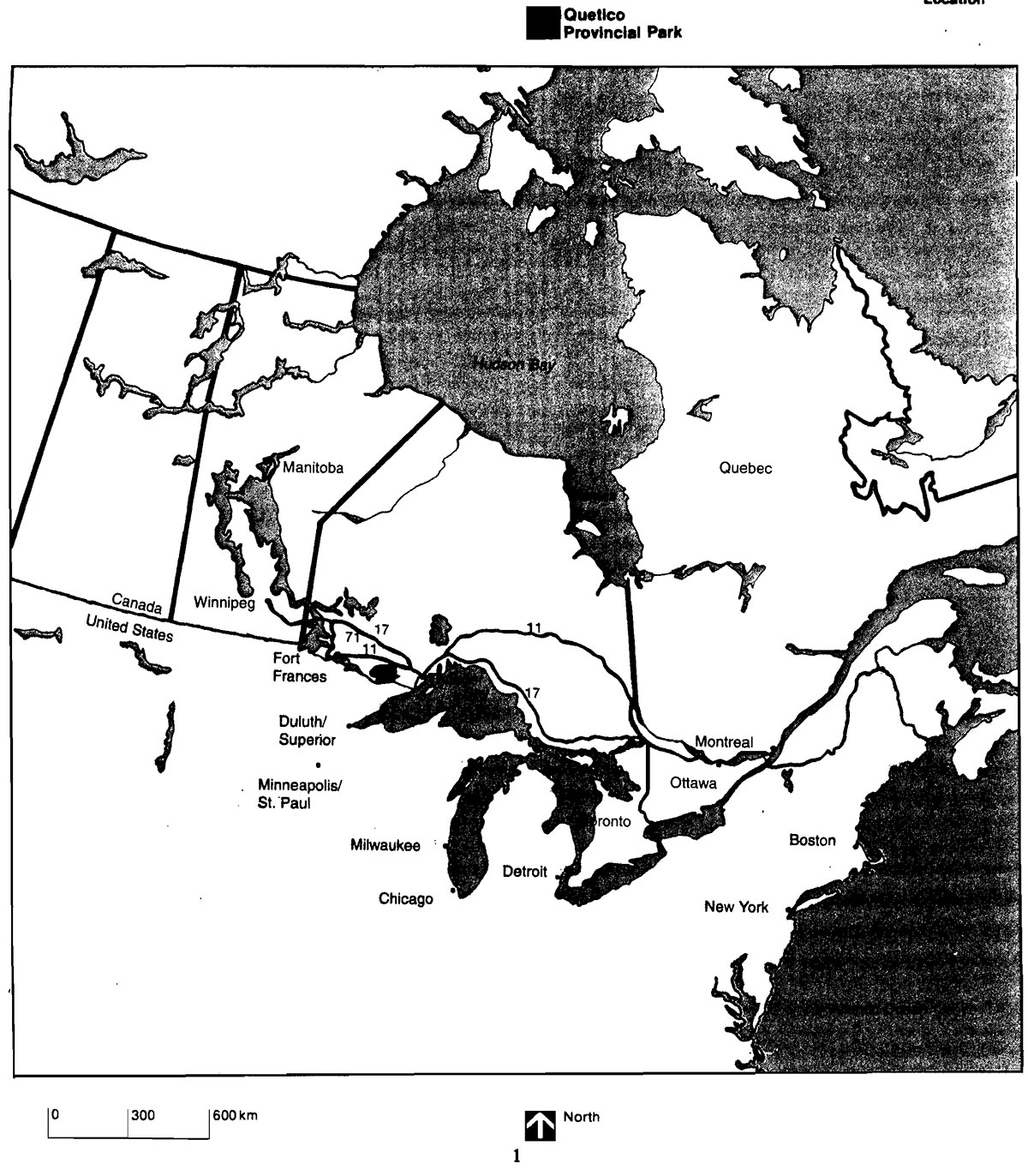
Figure 1: Location, Quetico Provincial Park

Enlarge Figure 1: Location, Quetico Provincial Park
1.0 Introduction
Quetico Provincial Part is one of Ontario’s larger wilderness parks and also one of the oldest, having been established in 1913. Located in northwestern Ontario, south of the town of Atikokan, approximately 160 km west of Thunder Bay and adjacent to the Canada-United States boundary (Figure 1), this vast area of parkland encompasses some 4758 square kilometres (475,819 hectares). The park’s numerous lakes and streams, its rich history and its wild, undeveloped landscape all contribute to its reputation as an area of unparalleled wilderness canoeing opportunity.
The Quetico Provincial Park Management Plan (now called Revised Part Policy) was approved in September, 1977. Its approval provided an expression of how the government intended the park to be planned, developed and managed over a 20 year period. During this timeframe, it is inevitable that events and changes will take place which were unforeseen or incorrectly forecasted during the planning process. To ensure that a management plan remains current and relevant, periodic reviews remain an essential stage in the planning and management process. Additionally, reviews provide an opportunity for evaluation of progress made to date and for public consultation on any aspect of park management. Traditionally, reviews have been undertaken at five-year intervals following initial management plan approval.
Reviews of the 1977 Quetico Management Plan were conducted in 1982 and 1988. A major amendment proposal by the Lac La Croix First Nation was reviewed in 1992. All public consultation was conducted jointly by the Provincial Parks Council and the Ministry of Natural Resources. Information packages were widely distributed. The packages outlined the review process, issues and/or proposals felt to be of interest or concern and suggested revisions or proposals.
In the most recent public consultation Provincial Parks Council and Ministry staff travelled to Atikokan and Toronto to hold workshops with key interest groups interested in Lac La Croix’s proposal regarding the Quetico Management Plan. Public meetings were hosted by the Provincial Parks Council in Atikokan and Thunder Bay. The Council received and recorded written and oral submissions on the Lac La Croix proposal. Additionally, interested members of the public were invited to forward comments expressing their views directly to the Chairman of the Provincial Parks Council.
Council members also undertook an extensive orientation to Lac La Croix. Upon evaluation of the input received and deliberation of their findings the Council formulated recommendations relating to the management of the park and forwarded these to the Minister of Natural Resources. Negotiations were then initiated with the Lac La Croix First Nation based on Council’s Recommendations.
This document integrates the accepted recommendations of the Provincial Parks Council and the subsequent outcome of the negotiated Agreement of Co-Existence. It replaces the Park Policy section of the management plan and will guide the administration of Quetico Provincial Park until the next review.
2.0 Park classification
Quetico will be planned, managed and operated as a wilderness park in accordance with the Ontario Provincial Parks Planning and Management Policies (1978). This document defines wilderness parks as:
"…substantial areas where the forces of nature are permitted to function freely and where visitors travel by non-mechanized means and experience expansive solitude, challenge and personal integration with nature."
As a wilderness park, Quetico’s primary emphasis will be protection. Humans are not considered to be incompatible with Quetico’s wilderness landscape; however, their presence is acceptable only within an ecological context whereby human numbers and technology participate rather than dominate.
Although the wilderness concept is intended to allow natural forces to function freely, one significant set of constraints must be recognized. Quetico’s management philosophy must not result in the endangerment of values external to the park or of certain specified values within its boundaries. As an example, should a forest fire within the park endanger capital intensive access zone facilities or exterior commercial timber stands, Quetico’s management policies must permit fire suppression action despite inconsistency with the wilderness ideal. Thus, insect infestations, disease and fire (though all natural components of the park’s ecosystem) may not be allowed to run their natural course without management intervention. However, if intervention is undertaken, every effort will be made to minimize its environmental impact.
Figure 2: Park Zone, Quetico Provincial Park
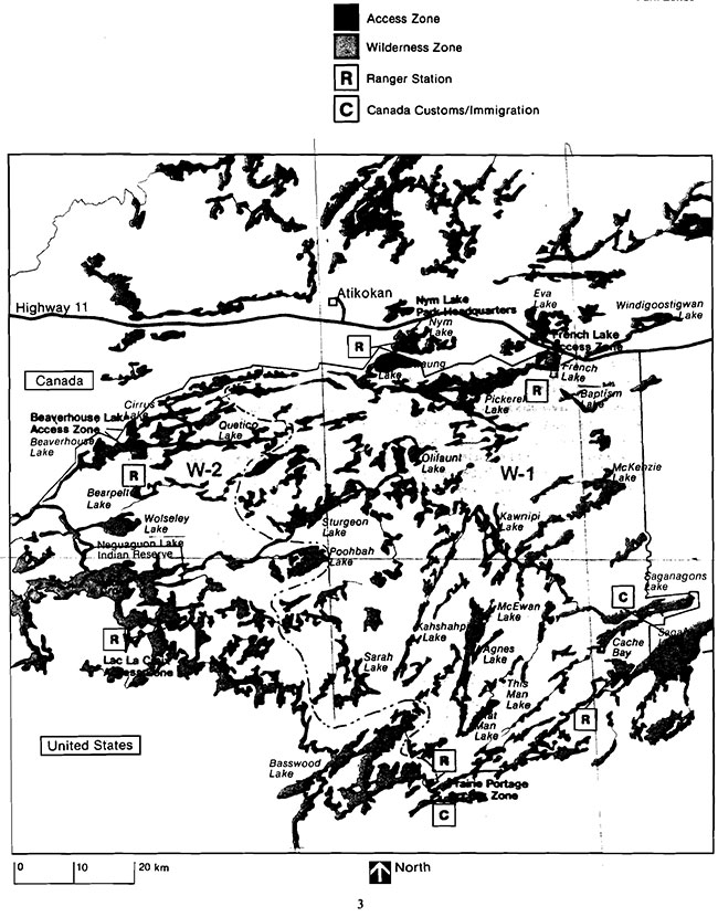
Enlarge Figure 2: Park Zone, Quetico Provincial Park
With reaard to user activities, low intensity recreation (essentially wilderness travel and associated activities), outdoor education and scientific research will be permitted. Although compatible with the wilderness concept, some degree of conflict is inevitable between these activities and the preservation component of the park goal. As a result, management action will be required to minimize this potential for conflict and to maintain the integrity of both the biophysical environment and the quality of the user’s recreational experience. Although the essential management technique employed to achieve this end will be the limitation of the amount and type of use, unobtrusive management of the biophysical environment will be permitted in instances where use is inevitably concentrated (e.g. campsites, portages, trails). The impact of such management input will be minimal, however, since related action will be undertaken only in response to conflicts precipitated by low intensity recreational activities.
3.0 Park goal
To preserve Quetico Provincial Park which contains an environment of geological, biological, cultural and recreational significance, in perpetuity for the people of Ontario as an area of wilderness that is not adversely affected by human activities.
4.0 Park objectives
Park objectives relating directly to the park goal provide specific direction to management and planning for the park. In addition to the principal objectives relating to Protection, the Lac La Croix First Nation, Recreation and Heritage Appreciation a secondary objective for Tourism is aimed at contributing to the continued viability of area tourist industries.
4.1 Principal objectives:
4.1.1 Protection
To protect the provincially significant elements of the natural and cultural landscape of Quetico Provincial Park from human influence or disruption by permitting the forces of nature to function freely, only taking action where necessary to preserve the environmental integrity of the park and its features.
Quetico Provincial Park will protect a representative portion of the ancient geological history, modern biological environments, and cultural features associated with site region 4W.
4.1.2. Lac La Croix First Nation
To reflect and support a renewed relationship between the Lac La Croix First Nation and the land base known as Quetico Provincial Park, which is regarded by the First Nation as sacrosanct, while acknowledging the wilderness values of this Park policy.
An Agreement of Co-Existence negotiated between the government of Ontario and the Lac La Croix First Nation, frames this relationship. The substantive elements of that agreement provide the basis for amendments to this plan.
4.1.3 Recreation
4.1.3.1 Quetico interior
To provide high quality, low intensity, wilderness experiences by providing outdoor recreation opportunities for extended, non-mechanized travel and associated activities through the park’s interior.
The target as expressed in the Atikokan District Land Use Guidelines is to provide 256,000 wilderness back-country travel opportunities annually. This represents the maximum use available. The quality of the park’s wilderness experience as measured through periodic environmental and social impact studies will be the determining factor in assessing bow much of this target represents acceptable levels of use.
4.1.3.2 French lake:
To provide high quality, moderate intensity, threshold wilderness experiences by providing outdoor recreation opportunities for non-mechanized travel and associated activities based from the Dawson Trail car campground and day use facilities.
The Dawson Trail Campground on French Lake currently provides 31,000 car-camping opportunities and 5,000 day-use opportunities annually. Classification as a wilderness park, and site constraints preclude further expansion of facility capacity at Dawson Trail, therefore no additional campsites will be developed.
4.1.4 Heritage appreciation
To provide opportunities for unstructured, individual exploration and appreciation of the natural and cultural heritage of Quetico Provincial Park.
Examples of glacier-carved granite, metasediments, and greenstone, one of the world’s oldest rocks are found in Quetico. The Poohbah Lake alkali-syenite complex is world famous among geologists. In the greenstone country, veins of copper, iron, asbestos, and gold may be seen.
Quetico contains elements of four life zones: boreal forest, mixed forest, prairie, and subarctic. Several species are listed in the Ontario Rare and Endangered Plants List. Stands of mature red and white pine line the shoreline of many lakes.
Moose, white-tailed deer, black bear, otter, beaver, bald eagles, ospreys, and common loons are frequently seen with occasional sightings of pine marten, fisher, timber wolf, or even a lynx.
The park is rich in cultural resources which define the pre-historic and historic use of the area. It is also significant as a natural and relatively undisturbed landscape. Pictograph sites are scattered throughout the park. Significant exploration and fur trade routes passed through the park. The southern boundary of the park has been nominated as part of the Boundary Waters-Voyageurs Waterway within the Canadian Heritage River System (CHRS). Past logging activity contributed to the development of the railway routes and communities in the vicinity of the park.
This objective will be achieved through unstructured individual exploration within the parks natural heritage education program and through the efforts of other agencies such as the Friends of Quetico Park, the Quetico Foundation and the Lac La Croix First Nation.
4.2 Secondary objective
4.2.1 Tourism
To provide Ontario residents and out-of-province visitors with opportunities to discover and experience a distinctive region of the Province and to encourage, where appropriate, the accrual of park tourism benefits to the Lac La Croix First Nation and the town of Atikokan, contributing to their long term viability.
The Ministry will continue to support the existing tourism-based economic activity which benefits the Lac La Croix First Nation and the Town of Atikokan. The provision of guiding and outfitting services from bases outside the Park will be encouraged, consistent with the park goal and principal objectives.
The Quetico Information Pavilion will act as a focal point for tourist activities in Quetico Park and promote tourism throughout the surrounding area. Other permitted tourism development is specified in the management policies of this plan.
5.0 Park boundary and land tenure
The last park boundary adjustment occurred in 1977. All forms of private land tenure incorporated within the park as a result of the adjustment will, in due course, be acquired by the Crown.
Prospecting, the staking out of mining claims or the working of mines is prohibited in Quetico Provincial Park. The titles to the mineral and surface rights for all mining claims, patents and licences of occupation located within the park are being acquired by the Crown.
Negotiations to acquire the remaining private land holdings will continue as funds and priorities permit.
A property plan will be prepared, approved and kept current for the park. It will provide guidelines for the acquisition, maintenance, operation and abandonment of all tenured land holdings.
6.0 Park zoning
Two types of zones have been employed to guide management within Quetico - namely central wilderness zones and peripheral access zones. Candidate historical and nature reserve zones will be examined and any that may require distinct management will be designated by amendment to this management plan at the next review. Areas within the wilderness zones and access zones may be designated by the Superintendent to facilitate approved research projects.
6.1 Wilderness zones
The wilderness zones, as shown in Figure 2, occupy all but about 250 ha of Quetico’s approximately 475,819 ha. The opportunities available within the wilderness zone comprise the raison d'etre of the park. Because of its dominance within the park, the wilderness zones are the focus of the detailed policy outline as contained in the following sections.
6.1.1. Wilderness zone 1 (W1)
The revered qualities of Quetico, as identified in the park’s goal and objectives will be preserved in this zone. This wilderness zone will remain the domain of the natural process; the presence of the recreationist will be that of a privileged intruder, activities will be restricted to those not compromising the integrity of the biophysical base. Mechanized forms of recreational travel will not be permitted.
6.1.2. Wilderness zone 2 (W2)
The creation of this zone recognizes that power boat and aircraft access by the First Nation, in the short term, is critical for the First Nation to realize its economic development needs and viability.
This zone is designated as an area which will be co-managed with the Lac La Croix First Nation. Power boat and aircraft use by the First Nation on lakes and waterways for the purpose of guiding is acceptable. In every other way the zone will be managed in accordance with the wilderness values as set out in the balance of this management plan.
A co-management regime between the First Nation and the Quetico administration will be designed and implemented. It will include, but not be limited to:
- the development and implementation of a short-term power boat access plan including methods of compliance and enforcement for the First Nation to operate, for the purposes of guiding, powered watercraft by no more than 10 horsepower (7.5 kw) motors, on lakes and waterways within the Zone
- the establishment of a process to work towards the elimination of power boat and aircraft use within Quetico Provincial Park and until such time, the mitigation of the impacts of power boat guiding on the Park’s wilderness values including the minimization and discrete location of aircraft landing sites and/or boat caches
6.2 Access zones
Quetico is served by six entry stations. Beaverhouse Lake, French Lake and Nym Lake provide northern entry opportunities and are accessible by road. Cache Bay (Saganaga Lake), Prairie Portage (Basswood Lake), and Lac La Croix are located on the southern boundary and are accessible by water only.
Entry stations provide route information, interpretive information, permit issuing services and also serve as an emergency contact.
In addition to the entry stations, the Atikokan Area office will provide permit issuing services for Atikokan residents. This will facilitate more convenient access to park permits.
A major emphasis in the planning and management of Quetico is the development and improvement of opportunities for northern access. The implementation of this basic policy will achieve a number of important objectives. Additional northern entry opportunities will facilitate the use of Quetico by Canadians and, in particular, residents of Ontario. In providing viable alternatives to the traditionally heavily used southern entry points, these entry opportunities will encourage user redistribution within the park. The resulting increase in user activity in areas adjacent to the park’s northern boundary will tend to increase the economic impact of Quetico on the surrounding local Atikokan area.
Four access zones (Fig. 2), each with an entry station, will serve Quetico and are located strategically about the park’s periphery.
- French Lake will maintain its present status as an access zone with limitations on further improvements or the introduction of new programs. The Stanton Bay road, external to the park, will continue to be utilized as an alternative entry for Pickerel Lake
- Cache Bay and Prairie Portage access zones will be maintained. Prairie Portage will continue to function as an entry station even in the event of a Canada Customs or Immigration absence. Cabin 16 and its access zone have been incorporated into the wilderness zone. Cabin 16 is considered to be an historic building and will be retained on site
- The Beaverbouse access zone includes the parking area on the north shore of the lake. If improvements are undertaken to the access road then relocation of the entry station will be considered
Two entry stations will be located external to the park:
- The Lac La Croix entry station will be re-located to the community of Lac La Croix
The present Lac La Croix Entry Station and its facilities may be considered for the Lac La Croix First Nation Youth Re-Discovery Camp and/or a Research Base. If the facilities will not be practically used for either purpose then they will be removed.
- The Nym Lake entry station will continue to function, as it has, external to the park. A road to Batchewaung Lake has been evaluated as an alternative access to the park but is not considered economically feasible at this time. If circumstances change it may be addressed again
Development of an Eastern Entry Station will not be undertaken until such time as demand warrants and a feasible site can be determined.
Discussions with interested Canadian outfitters will occur to see if mutually suitable aircraft landing sites on the periphery (particularly the east side) of the park can be found. A small portion of existing entry quota could be allocated to these locations.
The further designation or improvement of access will be contingent upon:
- site selection, and
- visitor use
The first criterion ensures that the site can physically sustain any required facility development, while the second minimizes the possibility of excessive user concentrations within sectors of the park’s interior. It is emphasized that the above-noted objective of increasing opportunities for northern access is achievable only if these site-criteria are not compromised.
As park user and resource studies provide more detailed information, adjustments to the roles of the respective access zones may be undertaken in the future. For example, a new access zone adjacent to the eastern boundary may tend to direct use to the same water corridors as the existing entry station at Cache Bay. Subject to the findings of park carrying capacity and user distribution studies, it may be necessary to adjust entries through any park access zones and/or entry points.
6.3 Special areas for research
Areas may be selected by the Park Superintendent to accommodate approved research projects. Management policies within these areas will differ from those applicable to the wilderness zone proper to the extent that both user activities and management practices may be more stringently controlled to ensure the viability of a given research project. The precise nature of these controls may vary from one research area to another depending on the requirements of individual projects. Research areas do not constitute a permanent area designation but will remain in effect for the duration of the project. An area designation could be maintained over a period of several years if the project dictates this requirement.
The identification and recording of sensitive features will be continued to provide information for specific management decisions which may be necessary to protect them. The location of these particular features will be plotted on a master map that will be kept at the park administrative headquarters. This inventory of special areas will lend itself to a variety of practical applications. Firstly, such information will serve as an important general data source. Secondly, it will guide the management and operation of the park in order to minimize the possibility of damaging special features. Thirdly, where fragility is not a factor, special areas will constitute a focal point for the park natural heritage education program.
(Note: see section 8.2 for additional research policy)
6.4 Watershed protection
The former buffer zone policy is rescinded.
Through amendment to the Atikokan and Thunder Bay District Land Use Guidelines (DLUG) the Quetico watershed is identified as an Area of Concern where the Ministry of Natural Resources will continue to comply with the requirements of the Environmental Assessment Act. Where major developments are proposed, and in reviewing plans for ongoing resource management activities, the Ministry will assure the protection of park values.
7.0 Resource stewardship
Resource stewardship within Quetico Provincial Park will be guided by the Ontario Provincial Parks - Planning and Management Policies for Wilderness Class parks. The maintenance of environmental quality and the protection of park values are fundamental to resource stewardship activities in Quetico.
The park’s resource stewardship programs will ensure that natural processes are allowed to function freely, within the constraints of public safety and the need to protect values both within and outside the park.
In keeping with the wilderness concept of allowing natural forces to function freely, the active management of the park’s resource base will be minimized. Management activity will be restricted generally to monitoring and research aimed at the detection of problems in their initial stages and the development of appropriate corrective measures as required. Where possible, potential problems will be avoided through such unobtrusive measures as regulation of use (e.g. user quotas, fish limits, motor ban). However, the necessity of actively managing the biophysical base through the suppression of such potentially destructive natural forces as insects, disease and fire will be unavoidable where these forces can be demonstrated to pose a threat to the values identified above. The need for a second category of active management input, an attempt to approximate natural processes, is more subtly induced. This need is created by the suppression of natural forces whose absence tends to cause significant changes in the character of the biophysical base. Thus, the effects of these natural forces, were they not suppressed, must be approximated through resource stewardship if Quetico’s wilderness environment is to be maintained. Prescribed bums may be considered to achieve this end.
In addition, management action will be required to minimize the impact on the biophysical base of park users engaged in compatible activities. Reflecting the distribution and concentration of users, this management requirement will be restricted generally to campsites and portages, and consequently treated in this document in the context of the development of recreational facilities. In addition, as noted above, policies regulating user activities and numbers will have an indirect effect and are later discussed in the context of user activities and visitor regulations. However, where the impact of user activity is more pervasive (e.g. man-caused fire), then associated policies are considered below.
Individual resource stewardship policies are discussed under a series of headings, each representing one component of the resource base. It is important to note that these components are not independent, but are highly interdependent. Thus, although the respective policies and implementation planning requirements are listed separately. the integration of all facets of resource stewardship will be a major objective of subsequent planning exercises.
7.1 Air
Concerns about the impact of airborne pollutants and acid precipitation on Quetico’s land and water base were heightened as a result of the Ontario Hydro coal-fired generating station at Marmion Lake. 16 km north of the park’s boundary. This generating station has been operational since 1986.
The Ministry of Natural Resources has co-operated with the Ontario Ministry of the Environment in the establishment of monitoring programs within and around Quetico. These involved the collection of water. soil and vegetation samples from pre-designated sites. Ontario Hydro also has studies related to precipitation chemistry, aquatic environments and air quality. Information collected has spanned 3-year pre-operational and 3-year post-operational phases of the Marmion Lake generating station.
Studies undertaken to date indicate that the generating station has had no measurable effect on the park environment. Cooperation with Ontario Hydro and the Ministry of the Environment will continue in monitoring programs, provided the latter are consistent with the wilderness management objectives for the park. If unacceptable environmental conditions are observed as a result of these studies, the Ministry of Natural Resources will make the appropriate representations.
An air resources plan will be prepared, approved and kept current for the park. It will address:
- existing conditions
- external influences
- monitoring
- interagency co-operation
7.2 Water
The Ministry of the Environment operates a monitoring program to provide data on the quality of park and area waters. This program provides for the early detection of any deterioration in water quality so that corrective measures can be undertaken as soon as it is possible.
DLUG amendments undertaken to permit development in areas adjacent to the park will consider water quality outside the Quetico boundary but within its watershed.
Water quality along the boundary waters, an area of international water flow, is recognized as a potential problem. Here, the quality of Quetico waters may be affected by factors outside the jurisdiction of both the park and the province. Continued co-operation with United States government agencies will be maintained in an attempt to ensure that Quetico’s values are not impaired.
Water levels within Quetico will not be controlled by dams located in the park. Existing dams will be removed or allowed to deteriorate. Most are simple, log or earth-filled structures constructed during the Dawson Route or logging eras. Often these structures, by not significantly controlling water levels, no longer fulfil a useful purpose. However, major dams presently control water levels on Tanner Lake, Pickerel Lake and Basswood Lake:
- The log dam on Tanner Lake will not be maintained
- The concrete dam on Pickerel Lake will represent an exception to this policy in Quetico. It will be operated to maintain the quality of French Lake beaches. Should extensive repair or replacement of the existing structure be required, the creation of a spillway or weir type dam will be considered
- At Prairie Portage, a third major dam straddles the Canadian-U.S. boundary between the Inlet Bay on Basswood Lake and Sucker Lake. This dam is maintained by American authorities
A water resources plan will be prepared, approved and kept current for the park. It will address:
- existing conditions
- external influences
- monitoring
- interagency co-operation
- control structures
- impacts of dam abandonment
7.3 Landforms
Sand and gravel deposits may be utilized for the limited maintenance required on wilderness campsites and portages. Care will be exercised in the selection of sources of sand and gravel to ensure that significant earth science or other sensitive features are not destroyed. Sites will be discreetly located and contoured upon the completion of individual projects.
7.4 Vegetation
As a general principle, the park’s vegetation will be allowed to respond to ecological processes without intervention. However, as noted in preceding sections, there are circumstances in which natural forces such as insects, disease and fire must be suppressed. Consequently, if the wilderness ideal is to be attained, it may be necessary to simulate the effect of the natural process through specific management action. As noted above, fire by prescription, emphasizing managed natural fire, is being investigated as a means to this end.
Logging will not be permitted in Quetico. Past cutover areas were scarified and planted prior to 1971. No further artificial regeneration will be undertaken in these areas. Associated timber access roads are regenerating naturally except for those being used for access to traplines.
Insects and diseases will be controlled only when important values external to the park are endangered. To this end, the ongoing program of monitoring and detecting areas with insect or disease infestation will continue.
Where control is necessary, it will be directly applied to the targeted insect or disease so as to have minimal effects on other components of the Park’s environment. Biological and physical controls will be used whenever feasible. Chemical controls may be employed only when monitoring programs indicate that a critical situation is developing and that no other technique will suffice. The area treated will be limited to the extent possible. Chemical treatment over water bodies will be prohibited.
A vegetation resources plan will be prepared, approved and kept current for the park. It will address:
- existing conditions
- general vegetation policies
- values to be protected
- utility line vegetation control
- management prescriptions to be utilized
7.5 Fisheries
Management of the fisheries resource will strive to protect a healthy, aquatic ecosystem with high quality recreational opportunities that are reflective of a fishery that is not stressed.
Commercial fishing will not be permitted in Quetico. Recreational angling is considered as one component of the total wilderness experience but not as an end in itself. Therefore users will be encouraged to fish only for food and not to carry fish out of the park.
Motorboat restrictions that have been implemented have resulted in a substantial reduction in angling pressure on affected lakes.
The manipulation of limits and seasons will comprise the major fisheries management tool employed within Quetico. Limits and seasons will be established on a periodic basis to ensure that the quality of the park’s fishery resource is maintained. In addition, these regulations may be applied on an individual lake basis and may vary from temporary to permanent restrictions and closures. Consequently, fisheries regulations applied within Quetico need not necessarily comply with those in effect outside its boundary.
The reintroduction of native species may be undertaken if feasible and supported through appropriate documentation. The introduction of non-native species will not be permitted. Furthermore, the removal of species for stocking programs outside the park and the collection of fish spawn will not be permitted unless the latter constitutes some part of an approved research project. Additionally, the possession of bait fish is not permitted.
Three lakes (Agnes, Pickerel and Robinson) were designated in 1980 for inclusion in the Quetico-Mille Lacs Fisheries Assessment Unit, established under the Strategic Planning for Ontario Fisheries (S.P.O.F) program. Guidelines will be formulated to ensure that fisheries assessment activities will have a minimal impact on wilderness visitors. Data collected on fish species and their habitat will benefit fisheries assessment programs and will assist in fisheries management within Quetico.
A fisheries resources plan will be prepared approved and kept current for the park, taking into account such factors as:
- management objectives
- a description of the existing fishery
- the Lac La Croix Agreement of Co-Existence
- management strategies and tactics
- monitoring of the park’s fisheries resource
A pre-requisite to the fisheries resources plan will be updated aquatic ecosystem inventory and harvest information. Initial emphasis will be placed on lakes within the W2 zone.
Quetico forms a separate fisheries management zone within the Atikokan Area Fisheries Management Plan.
7.6 Wildlife
Except as noted below, wildlife populations will not be actively managed.
Direct management of wildlife populations may be undertaken when the condition of wildlife populations within the park poses a threat to public health or safety, (e.g. nuisance bears) or to the health and well-being of animal populations external to the park (e.g. tularaemia).
The reintroduction of native species (i.e. woodland caribou) may be undertaken if feasible and supported through appropriate documentation. The introduction of non-native species will not be permitted. Furthermore, the removal of species for stocking programs outside the park will not be permitted unless it constitutes some part of an approved research project. It is recognized that wildlife habitat will be affected to the extent that fire is employed as a resource stewardship tool.
Hunting will not be allowed in Quetico.
A wildlife resources plan will be prepared, approved and kept current for the park. It will include:
- a description of the park’s existing animal populations
- mechanisms for the monitoring and control of unhealthy animal populations
- consideration of the effects of fire by prescription on animal habitat and their associated populations
- guidelines for the management of trapping activities
7.6.1. Trapping
Trapping will constitute the only form of commercial resource extraction permitted.
The ultimate exclusion of trapping, while desirable, is dependent upon a change in circumstances outside the bounds of the Quetico park management plan. The continuance of traditional aboriginal trapping, by the Lac La Croix First Nation, is assured by Treaty. No viable substitute for trapping, in terms of employment or income, is foreseen over the near-term. Therefore, qualified band members of the Lac La Croix First Nation may continue to trap and exchange their present lines for the foreseeable future. Traplines not licenced to members of the Lac La Croix First Nation will be transferred to members of the Lac La Croix First Nation or retired as of January 1, 2010, or sooner if circumstances permit. No other trapline transfers will Traplines will be permitted.
Trapping will be retired if they fall into disuse or if the provisions of the Game and Fish Act and Regulations are not met. Trapping will be permitted only for beaver and marten. Quotas will be established for these species to ensure sustained yield and healthy wildlife populations. No trapping of other species will be permitted. In addition, trappers will be required to provide relevant information to the Ministry as valuable input to Quetico’s wildlife management program.
Existing trapline cabins may be improved and new ones constructed, but there will be a limit of one cabin per trapline; where practical, one cabin will serve two or more traplines. Cabins will be discreetly sited, away from shorelines and off major canoe routes. Portions of traplines that are partially included in the park will be treated in the same way as those that are entirely within the park.
The following provision will apply to the use of mechanized equipment by trappers while travelling to and from and while tending their traplines:
- Aircraft: The use of aircraft will be permitted between September 15 and May 1 with the approval of the Park Superintendent
- Snowmobiles and ATV's: The use of snowmobiles and all-terrain vehicles (ATV's) will only be permitted during the trapping season in areas designated by the Park Superintendent
- Outboard Motors: The use of outboard motors with an engine rating not exceeding 10 h.p. (7.5 kw), for the purpose of trapping activities is permitted during the trapping season
No penalty will be assessed for undertrapping.
7.6.1.1. Management of aboriginal trapping
The management of aboriginal trapping will be defined through negotiation of a trapping agreement with the Lac La Croix First Nation. This agreement will address administration, species limitation, quotas, cabin construction and the issue of trapping on Hunter’s Island.
A joint trapping management body, with representation that is sanctioned by both the Lac La Croix First Nation and by the Ministry of Natural Resources, will be established to implement the trapping agreement and to manage day-to-day trapping matters on band member traplines.
7.7 Fire
Fire is the major management tool used to approximate a natural forest and wildlife habitat conditions. Fire management will therefore constitute a major component of overall resource stewardship planning within Quetico. The fire plan will emphasize the interrelationships of the various elements or components of the park’s resource base recognizing the need for integration of various branch responsibilities.
As a prerequisite to the implementation of a fire management program in Quetico, a thorough study of the relationship of fire to the ecology of plant communities in the park was initiated in 1975 and continued through 1976. This study emphasized an inventory of vegetative types, the dates and locations of old bums and the effects of fire on existing plant communities. Data analysis enabled the determination of the ecological role of fire with respect to all species or at least their major communities.
The fire plan will be tailored to suit the needs of the ecosystems within the park. This plan will consider the role of fire by prescription with emphasis on the following:
- managed natural fire
- the need for hazard reduction
- the prediction of fire behaviour for defined fire management decisions
- criteria for instantaneous fire management decisions
- wildfire control and suppression
- the evacuation of recreationists
Until such time as the fire plan has been developed, provincial and regional fire management policy will be followed. During the fire season, organized detection, a lightning location system and Ministry aircraft in the course of routine flying will cover the park area. Finally, cooperation between the Ontario Ministry of Natural Resources and the U.S. Forest Service in fire detection and suppression along the Canada-U.S. border area will be maintained.
Fire crews will be trained in fire fighting techniques which cause a minimal impact on resources. Heliports, aircraft landings, fire camp facilities and other fire fighting support installations will, where possible, be located away from major recreational waterways. Heavy equipment will not be used except where its application is essential to maintain public safety or to protect endangered external park values. Water bombers such as CL-215's, Cansos and Twin Otters may be used to bold problem fires until ground forces are in place. These bombers will use the lakes within the park to pick up water, following provincial guidelines for picking up water on lakes which are used by the public for recreational purposes. The use of foam and retardant systems will be minimized.
7.8 Cultural resources
The management of cultural resources will be directed to protection and heritage appreciation. The Ministry of Natural Resources will continue to work with the Ministry of Culture, Tourism and Recreation in identifying archaeological and historical sites which should be protected.
Cultural heritage sites will be protected. Incompatible uses that may threaten or detract from these sites will be prohibited.
The main historic values identified include pictographs, archeological encampment sites, abandoned logging camps and old ranger cabins. Periodic inspections of significant sites will occur with protective controls established as required.
The Lac La Croix First Nation is assured power boat and aircraft access to aboriginal resources for spiritual and cultural purposes. Cultural access is at the discretion of the Chief and Council, under advisement from Lac La Croix Elders, and notice to the office of the Superintendent. Discussion will address any difficulties created by such access.
A cultural resources plan will be prepared, approved and kept current for the park. It will:
- identify significant cultural sites
- determine specific protection requirements
- provide details on interpretive opportunities
The planning and management of the aboriginal resources component of the cultural resources plan will be a shared responsibility between the Lac La Croix First Nation and Quetico Provincial Park.
7.8.1 Canadian Heritage River System
The international waterway portion of Quetico, Middle Falls and LaVerendrye Provincial Parks have been nominated as the Boundary Waters-Voyageurs. Waterway under the Canadian Heritage Rivers System (CHRS). The Canadian Heritage Rivers System is a cooperative program developed and run by the park administrations of territorial, provincial and the federal governments to give national recognition to the important rivers of Canada. The primary objective of the program is to ensure that those rivers which are outstanding examples of Canada’s natural and cultural heritage, as well as offering outstanding recreational opportunities, are protected. The nomination of the Boundary Waters-Voyageurs Waterway was accepted by the Heritage Rivers Board in June 1986. It is expected to be designated officially as a Canadian Heritage Waterway in 1995.
8.0 Operations policies
Quetico will provide opportunities for wilderness recreation, outdoor education and scientific research.
In terms of numbers of users, the major user activity is wilderness recreation. Those recreational activities considered compatible with the wilderness orientation of Quetico are identified below. Because of their importance in maintaining a quality user experience, controls on the numbers and activities of users engaged in acceptable activities are discussed in the following section. In addition, the conditions under which scientific research will be permitted are outlined. Although specific mention is not made of outdoor education users, this user group will comply with the policies which apply to wilderness recreationists.
8.1 Recreation management
Recreational activities permitted within Quetico will include primitive travel (e.g. canoeing, hiking snowshoeing, cross-country skiing) as well as those activities that are associated and compatible with primitive travel (e.g. camping, fishing, photography, viewing). The types of primitive travel provided for will only be those that are consistent with the historical context of the park. For example, although horseback riding and sailing may be considered as primitive forms of travel, facilities for these activities will not be provided for within Quetico. In addition, the use of Quetico in the teaching or practicing of consumptive or destructive wilderness survival techniques will not be permitted. Similarly, those activities which may permanently deface the park landscape (e.g. use of pitons for rock climbing) will be prohibited.
In keeping with its wilderness ideal, the recreational use of all mechanical forms of transportation will be ultimately prohibited. This ban includes motor powered watercraft, airplanes, snowmobiles and all-terrain vehicles. Existing regulations ban motor powered watercraft from all waters within the park with the following exceptions:
- Watercraft powered by not more than 10 h.p. (7.5 Kw) and used by a member of the Lac La Croix First Nation who is also a member of the Lac La Croix Guides Association, may be operated for the purposes of guiding, subject to the annual operating strategy, in the W2 zone
- Watercraft of unlimited horsepower and used by a member of the Lac La Croix First nation who is also a member of the Lac La Croix Guides Association, may be operated for the purposes of guiding on Wegwagum Bay of Lac La Croix up to Twin Falls
- The need for overnight guided trips may be considered by the Implementation Committee in light of the goal to eventually eliminate mechanized guiding from the park. Additional impacts on the resource and on other park visitors are significant considerations in arriving at a decision
Guided trips will conform with all other policy direction. The practice of utilizing motorized watercraft for towing purposes will be discouraged, with the possibility of enacting regulations to prohibit this use should it continue.
Existing regulations prohibit the use of other motorized equipment such as chain saws, power augers and generators.
Aircraft landings required to facilitate day use guiding by a member of the Lac La Croix First nation who is also a member of the Lac La Croix Guides Association, are permitted subject to the annual operating strategy of the W2 zone.
Beaverbouse Lake Entry Station will continue to be utilized as an aircraft landing location in the park. Parks staff will monitor potential conflicts this may cause following any improvement of road access to the Beaverhouse Lake access zone from Highway 11.
For a five year trial period, Cache Bay Entry Station will also be utilized as an aircraft landing location. Impacts on the resource and on other park visitors will be monitored and assessed. During this time period Canadian outfitters may conduct a market analysis to help determine the future viability of this service. At the end of the trial period the results will be used to determine whether or not Cache Bay should continue to be used as an aircraft landing location.
In flying to access points, outfitters will be asked to circumnavigate the park in order to avoid negative impacts on wilderness users. To further minimize the impact of overflights on the wilderness user, all air carriers will be requested to fly no lower than 1,220 metres over the park.
8.1.1 Visitor regulation program
A visitor regulation program is in place to minimize environmental deterioration and maintain the quality of the user’s wilderness experience. This program restricts use levels and user activities to those compatible with the park’s goal and objectives.
The program is based upon a defined recreational carrying capacity for the park, which in turn has been derived from the analysis of the capabilities of both the resource base and of existing developed facilities (mostly campsites) to sustain use and of the tolerance of wilderness users to encounters with other user groups. The visitor regulation program ensures that this capacity is not exceeded. It is emphasized that, as a general principle, every effort will be made to ensure that visitors experience the maximum freedom of choice once entry to the interior bas been gained. The program strives to impose necessary regulations on park visitors prior to their arrival at an access zone through daily entry quotas.
Data collection leading to the development of entry quotas was initiated in 1970 when Quetico’s shorelines were inventoried and evaluated to determine their capabilities for canoe-camping. In subsequent years, an ongoing program has identified and monitored all existing campsites. Complementing these inventories of existing and potential campsites is a study of the numbers, characteristics and distributions of Quetico canoeists. This study, based on a trip travel report format, was initiated in 1975 and will be continued as required in order to update the data base. Based upon these two basic sets of information (campsite supply and user distributions related to campsites), the visitor regulation program was developed. Recognizing the ideal of imposing a minimum of travel regulations on the park visitor once entry to the interior has been attained, this program establishes a daily entry quota for each entry point, ensuring that the interior campsite capacities of defined areas are not exceeded. To this end, a travel prediction model was employed. Entry quotas, together with a visitor reservation system, were implemented in 1977.
In addition to entry quotas, other regulations, primarily regarding party size and length of stay will be employed. The regulation limiting wilderness campsite occupancy to one party per site will continue. The maximum party size will remain at nine people. Campsites will be monitored for site deterioration. Groups travelling together will limit themselves to a maximum of two parties, so that their impact on park resources and the experience of other wilderness visitors is minimized.
An extensive education effort promoting minimum impact camping will be instituted as part of the natural heritage education program. A specific "organized group" package will also be prepared for this purpose.
There will be no limit to the maximum length of stay in the park for individual parties. However, limitations may be imposed at campsites situated within congested sectors of the park, particularly in the vicinity of access zones and busy travel corridors.
To maintain the quality of the wilderness environment additional regulations are required. The use of non-burnable food and beverage containers is prohibited. Metal foil and other refuse, which is not burned, must be carried out of the interior by the park visitor. These regulations came into effect in 1978 following an information program in 1977. Also, in areas of critical firewood shortage, or during periods of extreme fire hazard, visitors may be required to carry portable stoves.
In order to ensure full control of user activity, the establishment and use of outpost camps will be prohibited.
It may become necessary in the future to establish separate quotas for residents and non-residents to ensure that residents have access opportunity to their resource. As demands continue to increase, and the park’s defined capacity cannot be exceeded, the overwhelming disparity in proportion between residents and non-residents will result in a situation whereby residents might be denied access. Non-resident quotas will be incorporated into the visitor regulation program if required to avoid such an outcome. This ratio will ensure that within the constraints imposed by the defined wilderness recreational carrying capacity, the satisfaction of resident demand is given priority.
In addition, a higher entry fee for the southern entry points through Prairie Portage, Lac La Croix and Cache Bay entry stations will be investigated.
A visitor regulation plan will be prepared, approved and kept current for the park. It will:
- address existing uses, users, numbers, impacts
- highlight park regulations specific to Quetico
- establish cycles for the collection of travel and visitor information data as well as identify specific degrees of control that may be needed
8.2 Research
All park research is subject to provincial policy Research Activities in Provincial Parks.
Non-manipulative and non-consumptive scientific research in Quetico Provincial Park is appropriate and will be encouraged. Park staff will work co-operatively with appropriate agencies to ensure that research activities within the park remain pertinent to the parks goal and objectives.
Continuing research is particularly suitable in the areas of:
- visitor entry, distribution and impact on the park environment and other users
- environmental monitoring for external influences
- cultural resources: archaeological, historical
- natural resources: flora, fauna
- species and habitat monitoring
- insect and disease monitoring
- fire ecology and management
- re-introduction of indigenous species (flora, fauna)
- vegetative succession
Individual research projects must contribute to the existing knowledge of the park’s resource base, have practical application to park management problems or employ the park as a base reference where no viable alternatives exist. Thus, Quetico will not serve as a generalized laboratory for all types of scientific research. Furthermore, regardless of their respective orientations, all research projects must be compatible with the park’s goal. Depending on both the value and the requirements of a given project, a research area may be designated.
Individual research projects, regardless of the proponent and including those undertaken by government staff, will be submitted to the Ministry of Natural Resources, Park Superintendent for approval and may be undertaken only with written permission. In addition to permitting the initiation of the project, this authorization will specify any conditions upon which approval is contingent. Finally, researchers will be required to report to the Park Superintendent in writing on the findings of each research program. If the duration of a given program is greater than one year, the submission of an interim report will be required within six months of the close of each field session.
A number of restrictions must be applied in order to minimize the impact of the research project on both the resource base and on other users. The removal of biological specimens and archaeological excavations may be permitted, but only by specific authorization. It is emphasized that archaeological research, in addition to complying with the Provincial Parks Act, must also be licenced under the Ontario Heritage Act. All research projects, resulting in the approved alteration of a site (e.g. digging, plant collecting, anchoring of instruments, etc.) must include a rehabilitative component which will restore the site to its original condition as closely as possible. Finally, the construction of permanent structures within the park to facilitate a research project will not be permitted however, parks staff will co-operate in any feasibility study to locate a base for Quetico Park research in the Atikokan area outside the park itself.
A research plan will be prepared, approved and kept current for the park. It will identify:
- existing research
- further research needs
- how they should be addressed
- who should address them
- how research should be conducted to be consistent with the park goal and objectives
8.3 Natural heritage education
Natural heritage education within Quetico Park will be delivered at a Major Activity level. This level includes the components of Information, Interpretation and Outdoor Recreation.
The level stresses a high quality and comprehensive approach in the interpretation of park resources and the development of outdoor recreation. It further ensures that the park user:
- can develop an appreciation of the intent and meaning of the wilderness concept as set down in the park goal
- can become acquainted with individual park objectives, themes and subthemes
- can have access to information of specific interest and can be made aware of the various policies and regulations which have a bearing on their activities within the park
The natural heritage education program will emphasize two major themes, each containing one or more sub- themes:
- The wilderness concept is of paramount importance. This theme will explore the philosophy of wilderness and thus attempt to foster among users an appreciation and understanding of the dynamics of ecological processes
- The second major theme is a cultural one. It will delve into the history of Quetico from the earliest times to the present, including the aboriginal cultures, the fur trade, the Dawson Route and the more recent logging eras
An Ojibwa interpretive programme will be planned, developed and implemented through the Lac La Croix First Nation.
An important practical aspect of the natural heritage education program will be to promote among park users an acceptance of park management policies. This objective will be achieved by informing the park user of the intent and need for particular park management policies. Here, the underlying assumption is that park users who are aware of the reasoning behind a given policy will be more likely to accept its need and to comply with it. A comprehensive communications strategy as well as a wilderness/recreational skills programme will help achieve this end. This approach is appropriate in a park such as Quetico where user control and enforcement activities are extremely difficult.
Quetico’s vast size and wilderness orientation make the challenge of program design and administration particularly great. Within the wilderness zone (the destination of the typical park visitor), users are widely dispersed and on-site facilities incompatible. Even within access zones, and at entry station facilities the wilderness orientation of the park precludes the use of certain highly technical interpretive devices. In response to these limitations, the natural heritage education program will be focused at entry stations and will stress personal communication and high quality publications.
Information will be provided to interior users at entry stations prior to their entering the wilderness zone as well as through occasional contact with park rangers encountered while in the interior.
Natural heritage education facility development will not occur within the wilderness zone.
The Quetico Information Pavilion, was opened at the French Lake access zone in 1985. It provides. workshop and Storage facilities for natural heritage education staff, an indoor amphitheatre and various educational displays for school groups and the travelling public. Interpretive programs presented at this facility will emphasize cultural themes as well as wilderness-oriented sub-themes which may not be easily interpreted in the wilderness environment. The John B. Ridley Memorial Research Library and Archives has been developed, by the Quetico Foundation, for the use of park visitors and researchers.
To complement the Lac La Croix interpretive programme the following facilities will be developed:
- a multi-use activity centre, in the form of a roundhouse, at Dawson Trail Campground
- space for Ojibwa interpretation within all Quetico Park Entry Station facilities
- interpretive facilities will also be developed within the community of Lac La Croix under the Agreement of Co-Existence
A natural heritage education plan will be prepared, approved and kept current for the park. It will provide detailed strategies on each of the three components of the program, elaborate on previously stated direction and determine the means of implementation.
8.4 Marketing
Marketing within Quetico will be consistent with the park goal and objectives.
Specific park marketing efforts will be directed towards:
- increasing Canadian resident use
- more effective use of northern entry points
- promoting interior and threshold (French Lake) experiences
- promoting wilderness travel packages
- informing present and potential park visitors about wilderness experiences
- providing public education on wilderness and its values, and the three primary objectives of the park
Marketing efforts will recognize the link between local commercial services and the park. Emphasis will be placed on the utilization of alternate recreational opportunities available in Atikokan and surrounding area.
A marketing plan will be undertaken in co-operation with the Ministry of Culture, Tourism and Recreation, tourist outfitters and the local communities. As well, local business and park visitors will also be consulted.
9.0 Recreational facility development
Recreational facility development will be limited to prevent deterioration of Quetico’s physical environment as a result of user concentrations and, in so doing, to ensure a quality user experience.
In keeping with the wilderness concept, the development of recreational facilities will be strictly limited within Quetico’s interior. Facilities will be sufficient only to permit compatible wilderness activities and to minimize the environmental impact of associated user concentrations. Recreational facilities in the interior will be restricted primarily to campsites, portages and trails. It is largely in response to this substantial limitation of facility development, dictated by the wilderness orientation of Quetico, that the management plan emphasizes the control of the number and activities of users to maintain both the integrity of the resource base and the quality of the user’s experience.
In addition, this section also outlines the facility requirements of access zones. As emphasized previously, the purpose of access zones is to facilitate visitor entry to the park, not to provide a recreational experience as such. Consequently, facilities within access zones will reflect this basic orientation.
Needed development structures in the wilderness zone for park radio communications and fire detection will continue to be permitted exceptions to this general policy.
An interior facilities plan will be prepared, approved and kept current for the park. It will incorporate park standards for:
- campsites
- portages
- trails
- maintenance levels and frequency
9.1 Canoe routes
Development of canoe routes will be undertaken only to the extent that facilities associated with primitive canoe travel, namely campsites and portages, will be provided.
9.2 Campsites
The ongoing inventory and evaluation of existing and potential campsites will be continued to derive a figure for the total campsite potential of Quetico. This estimate of total campsite potential will not be based solely on physical criteria but also the tolerance of users to contact with other user groups. Thus, an additional component of this carrying capacity project is the development of a campsite spacing standard. This standard will be a flexible one and will be based on the assumption that sight and sound contact between adjacent campsites is undesirable. Furthermore, criteria for campsite location will avoid development adjacent to portages, fragile features or features of special interest which are specifically identified in natural heritage education literature. In order to satisfy this requirement, some existing campsites may have to be closed.
Ultimately, all campsites will be designated. Initially, their designation will be accomplished in natural heritage education literature and at individual sites in areas of relatively high user concentrations (e.g. in areas adjacent to access zones or along travel corridors). On-site designation will be accomplished primarily through the provision of primitive stone fire-places. Docking facilities will not be provided. Permitted campsite maintenance includes surface treatment and the discreet transplanting of local native plant species for site stabilization or rehabilitation.
Park visitors will be educated in acceptable methods of human waste disposal. Box privies may be provided on high use sites.
9.3 Portages
Portages will consist of primitive pathways developed to provide stable and safe passage between segments of canoeable waterways. As a general principle, neither docks nor signs will be permitted at portage landings; however, in situations involving extreme hazard, signs may be used. Otherwise, appropriate information on the location of and safe approach to portages will be provided in the park’s natural heritage education literature.
The condition of portages will be continually monitored as a prerequisite to an ongoing maintenance program. Acceptable portage maintenance will include brushing, the construction of log causeways and selective surface treatment. Mechanical portage facilities will not be developed, nor will mechanical devices introduced by users (e.g. portage wheels) be permitted.
9.4 Trails
Back-country hiking opportunities will be developed in response to user demands and within the constraints imposed by the resource base. Criteria for the selection of trail routes may include:
- opportunities for wildlife viewing
- avoidance of contact and possible conflict with canoeist groups
- access to features of interpretive or aesthetic value
- avoidance of areas where site fragility is an over-riding consideration
- utilization of old roadway corridors
Trails will consist of a primitive, single file path designed to provide the user with an interesting and varied hiking experience. The condition of the trails and their degree of use will be continually monitored so that timely decisions can be made with regard to facility maintenance and user control. Appropriate trail development and maintenance will include such procedures as brushing and the construction of log causeways. Primitive bridge construction may be permitted, but only in exceptional circumstances. Management of trail-related campsites will be guided by the same principles as those governing the management of waterway-related campsites.
9.5 Access zones
Facilities provided at access zones, although similar, will vary mainly in response to mode of access. Where access is gained primarily by water, appropriate facilities will include the following: an entry station, a natural heritage education facility, a canoe-launching facility, public sanitary facilities, staff quarters and warehouse facilities. Where access is by road, additional facilities may include a parking lot and campsites.
The Stanton Bay access to Pickerel Lake will be improved and consideration will be given to improving the Beaverhouse access road if warranted by demand.
Canoe storage racks may be permitted for use by approved Canadian outfitters at the following access points:
- Dawson Trail Campground at French Lake
- Beaverbouse Entry Station
- Lac La Croix Entry Station
Canoe storage will also be permitted at Cache Bay Entry Station through the five year trial aircraft landing period.
The Ministry of Natural Resources will set standards for canoe storage facilities, but will not assume responsibility for security or liability.
Short term canoe storage for organized groups can be permitted if local outfitters are not able to reasonably provide this service.
Other outfitting services will not be provided at access zones.
The number of parking spaces and campsites, where provided, will be dependent on the capacity of the site and the entry quota established for a specific access zone. The duration of stay at an access zone campsite will be limited to one night. These campsites may be used when a party is unable to enter the park as a result of the quota system or due to inclement weather conditions, or when the party arrives at the zone too late in the day to be reasonably expected to embark on either the interior trip or the homeward journey.
Location, design and materials used for the construction of buildings will be consistent with the wilderness orientation of the park. In addition, site design standards will be applied to road design, construction and maintenance in order to provide an aesthetic access to Quetico.
Utilities such as electric power, telephone or gas may be provided at access zones depending on their feasibility in a given situation and only when essential for service.
A Highway 11 sign plan will be developed to improve park identification along the highway corridor. The plan will take into consideration the area between the East Boundary and the Flanders road into the Beaverhouse Access Zone and will be developed in co-operation with the community of Atikokan and the Ministry of Transportation.
9.5.1 French Lake access zone
The Dawson Trail Campground on French Lake has traditionally provided opportunities for car-camping and day-use activities.
These facilities contribute towards the principal put objectives of recreation and heritage appreciation by providing a facility base for educating park visitors about the values of wilderness to society and by providing opportunities for threshold wilderness experiences. Contributions to the secondary tourism objective of Quetico will be achieved by:
- upgrading facilities to enhance the visitors stay, and in turn attracting new visitors and increasing the average length of stay
- marketing services and attractions in the entire Atikokan area which includes the town, Highway 11 and adjacent areas. Emphasis will be on encouraging put visitors to discover and experience area attractions outside the park
Special needs visitors will be encouraged to participate fully in threshold wilderness experiences. This opportunity will be explored in co-operation with those groups and organizations who serve a special needs clientele.
Where necessary, improvements will be undertaken to ensure public access, health and safety as well as environmental protection. Development will be limited to facilities which enhance visitor experiences without expanding campground or day use capacity, and with due regard for the ark’s wilderness character.
In other respects, development permitted within this zone will be similar to that of the park’s other road access zones.
10.0 Administration policies
Park operations will occur in accordance with the Ontario Provincial Parks - Planning and Management Policies, Quetico Revised Park Policy 1995 approved Quetico Resource Stewardship Plans and Operations Plans. The latter plan provides park staff with information required to operate the park on a day-to-day basis. In addition to addressing the operations policies which follow, the plan will include such topics as budget, staffing, maintenance schedules, enforcement and emergency services. The provisions of the plan will be consistent with Ontario Provincial Parks Operating Standards, and will be reviewed annually and updated as required.
In addition to the above, significant reference will also need to be made to the Agreement of Co-Existence and its accompanying Implementation Policy.
As a guiding principle, every effort will be made to ensure a high standard of park management activity by promoting an understanding of the park’s goal and the concept of wilderness to all levels of staff. To this end, individuals with daily operational responsibilities in the interior will be assigned to a sector of the put and, with their staff, will live and work there throughout the operating season. In addition, all other staff with some level of responsibility for park management will be required to spend a period of time within the park’s interior each season.
The daily activities of the management staff will be compatible with those of park users to the fullest extent possible. For example, park staff will generally be required to use canoes for such ongoing tasks as interior maintenance and enforcement. Where exceptions are made, it must be possible to prove that the success of the particular task is largely contingent upon the use of a given form of mechanical transport.
10.1 Administration
The Park Superintendent has been delegated the responsibility for the management and operation of the park. Where necessary, the resource stewardship needs outlined in this plan can be achieved by co-ordinating efforts with adjacent Area Managers.
Staffing and funding levels will be sufficient to meet the minimum standards of operation for the park interior and the French Lake access zone. Additional funds will be allocated to provide more effective management of the Quetico Interior. Staff will continue to assess park operation needs and meet them as efficiently and effectively as possible. The Ministry and the Lac La Croix First Nation will work together to further employment opportunities for First Nation members. The Agreement of Co-Existence identifies a goal of fifty percent (50%) employment for First Nation members in those employment opportunities available through the Ministry of Natural Resources in the Quetico area by the year 2015.
Quetico Park’s organization will remain flexible and may be adjusted as required.
The park’s administrative headquarters will be the Nym Lake Base. Secondary administrative facilities (including a work/training centre) will be located near the community of Lac La Croix. Administrative facilities will be adjusted as required to facilitate the management of the park and peripheral access zones and entry stations.
Quetico will be divided into operating units. Boundaries are flexible and defined on the basis of workload. Each of the operating units will be supervised by a Zone Ranger. Within each of the respective areas, the Zone Ranger’s responsibilities will include: wilderness management, law enforcement and natural heritage education. Throughout the operating season, the zone ranger and staff may be based at an entry station within their particular management area. The La Croix- Beaverhouse operating unit will be fully operated aud staffed from the community of Lac La Croix by the year 2015.
Communication is recognized as an important component of park management. The District Manager and Park Superintendent will establish and maintain regular liaison with affected interest groups to achieve this purpose.
10.2 Administration of Agreement of Co-Existinence
The Ministry of Natural Resources and the Lac La Croix First Nation will establish an Implementation Committee to complete the negotiation of, and implementation process for programs, initiatives and management regimes including implementation timeframes.
Implementation policy will address:
- an effective implementation mechanism with independent implementation resources
- provision of opportunities for employment and economic diversity
- sensitive management of mechanized guiding zone (W2)
- a process to phaseout mechanized guiding
- productive Namakan Co-Management negotiations
- early road construction
- open communications
For further detail, reference must be made to the Agreement of Co-Existence.
10.3 Implementation planning
Consistent with direction provided in this revised park policy, preparation of individual resource stewardship plans will receive high priority for completion in order to give more specific direction to the operational program.
Specific resource stewardship plans to be prepared include:
- property plan
- short term power boat access plan
- air resources plan
- water resources plan
- vegetation resources plan
- fisheries resources plan
- wildlife resources plan
- cultural resources plan
- fireplan
Other implementation plans to be prepared include:
- visitor regulation plan
- research plan
- natural heritage education plan
- marketing plan
- interior facilities
- highway 11 sign plan
Individual plans may combine components wherever suitable. However, it is recognized that the schedule and organization of all implementation planning must be flexible and capable of responding to a wide range of considerations (e.g. the complexity of the problem, the availability of data, staffing and funding). Such considerations will combine to dictate the final plan. It should be stressed, however, that regardless of the form, integration of individual efforts must be achieved.
As a minimum all individual plans will be prepared and approved according to the most up-to-date direction. Public input will take place appropriate to the level of concern and/or interest in the particular plan involved. This will be determined during the preparation of the terms of reference for each plan.
10.4 Operational planning
Annual operating plans will be prepared for each aspect of park operations such as: administration, park operations, W2 powerboat and access, maintenance and development, as well as interior operation. These plans will facilitate the implementation of this park policy and successive management plans through a detailed work program complete with targets and schedules.
10.5 Management plan review
The Quetico Provincial Park Policy must be sensitive to change and must be kept current and relevant. The review process provides a mechanism for modifying management policies as may be necessary. The next scheduled review is in 10 years time, however, the need for an earlier review will be assessed in five years. At that time, or at any time in the future, changing circumstances may indicate that a review or plan ameadment is warranted. Established planning procedures and public consultation requirements for plan review and amendment will be followed.
The annual operating plans, designed to enable the orderly implementation of park policies, will be reviewed and updated annually.
11.0 Implementation priorities
The implementation of developments and improvements in the Park will be in accordance with the phases as described below and consistent with the Agreement of Co-Existence between Ontario and the Lac La Croix First Nation. Each phase deals with the preparation and implementation of various plans and site and development concepts. The phases are not intended to be mutually exclusive. Priorities may be adjusted based upon significance of issues, the availability of resources and other opportunities.
Projects and activities listed here, or resulting from the preparation of subsequent Implementation Plans, will be undertaken with due regard for the Ministry’s EA obligations.
11.1 Phase 1
- Administration
- Initiate necessary Regulation changes
- Develop Implementation Strategy for the Lac La Croix Agreement of Co-Existence
- Improve Interest Group liaison
- Resource Stewardship Plans
- Fish
- Fire
- Research
- Cultural
- Vegetation
- Operations Plans
- Visitor Regulation
- Marketing
- Natural heritage education
- Interior Facilities
- Developments
- Complete Dawson Trail Barrier Free Access
- Lac La Croix Work Centre
- Lac La Croix Youth Re-Discovery Camp
- Lac La Croix Entry Station/Interp Centre
- Dawson Trail Roundhouse
11.2 Phase 2
- Resource Stewardship Plans
- Property
- Wildlife
- Air
- Water
- Development
- Stanton Bay Access improvement
- Highway 11 Corridor Signage improvement
- Complete Dawson Trail redevelopment
12.0 Summary of public consultation
The Ontario Provincial Parks Council conducted the public consultation phase of the Lac La Croix Amendment Proposal. An information tabloid was jointly prepared between the Ministry of Natural Resources and the Lac La Croix First Nation and was widely distributed.
Park’s Council conducted 2 workshops with key interest groups and held 2 public meetings. In addition, Ministry staff met with key groups on a variety of occasions.
The Lac La Croix First Nation was a continuing participant throughout the amendment process - from planning through to very active involvement in the entire public participation process. This has included: group sessions at workshops; public meetings, presentations to interest groups; and the opening of band members homes to host visits by Parks Council and by interest groups. The First Nation went to peat lengths to extend themselves in helping to further the understanding of their own issues and aboriginal issues on a broader scale.
In addition, several key interest groups spent a considerable amount of time and resources in efforts to gain a complete understanding of all the issues involved. These groups included: the Federation of Ontario Naturalist, the Friends of Quetico, Atikokan Outfitters, Thunder Bay Field Naturalists, Wildlands League and the Friends of the Boundary Waters Wilderness. Other groups that also put in notable efforts included the Quetico Foundation, the Atikokan Economic Development Office and the Ontario Federation of Anglers and Hunters.
Over 600 submissions were received. Generally, the quality of public input was very hip. Expressions of opinion, for the most part, were considered and expressed in a very thoughtful manner.
Synopsis of Public Opinion: There was adamant opinion that Quetico’s wilderness status must be maintained. At the same time there was also broad support for the Lac La Croix community, acknowledgement of the wrongdoings that have been suffered and acknowledgement of the communities relationship with Quetico. From much of the input, and discussion, came a clear sense that community issues must be addressed positively but not at the expense of Wilderness Policy (motorboats). If there was no alternative to expanding motorboat opportunities in the short term then there needed to be a phaseout schedule.
- 73% opposed to motorboats in Quetico (40%) or the extension of motorboat use (33%)
- 55% preserve the wilderness (49%) or maintain as a sanctuary (6%)
- 36% need more time to study alternatives (13%) or explore other alternatives (13%) or need a longer time frame for the review (10%)
- 31% support long term recommendations as means of earning a livliehood
- 26% suggested other alternatives
- 22% opposed to extension of trapping (11%) or any trapping (11%)
- 18% support trapping proposal with conditions (12% or without special conditions (6%)
- 15% support implementing short and long term proposals on Crown land (9%) or building a road outside the park (6%)
- 15% concerned about no definite phase out of short term proposals or commitment of funding for implementing long term proposals
- 12% expressed that non-aboriginal outfitters would get the most benefits from implementing the proposals
- 11% had other suggestions to revise the park policy
- <10% other responses
13.0 References
Quetico Provincial Park Advisory Committee, 1972 Resort of the Quetico Provincial Park Advisory Committee
Ontario Ministry of Natural Resources, 1977 Ouetico Provincial Park Master Plan
Ontario Ministry of Natural Resources, 1978 Ontario Provincial Parks Planning and Management Policies
Balmer, Crapo and Associates, 1979 A Strategy and Action Plan for Tourism in the Atikokan Area
Ontario Ministry of Natural Resources, 1981 Information. Master Plan Review 1981
Ontario Ministry of Natural Resources, 1982 Ouetico Provincial Park Revised Park Policy 1982
Ontario Ministry of Natural Resources, 1983 Atikokan Area land Use Guidelines
Ontario Ministry of Natural Resources, 1983 Thunder Bay District Land Use Guidelines
Andersen Management Services, 1987 Township of Atikokan: A Study of a Changing Community
Ontario Ministry of Natural Resources, 1987 Fur Management Operational Guidelines. Atikokan Area (unpublished draft)
Ontario Ministry of Natural Resources, Fur Management in Ontario (Trapper Education Series)
Ontario Ministry of Natural Resources, 1987 Reservation Statistics (Unpublished)
Ontario Ministry of Natural Resources, 1987 Provincial Park Management Planning Reference
Ontario Ministry of Natural Resources, 1988 Information Package. 1988 Policy Review
Ontario Provincial Parks Council, 1988 Briefs Presented (Unpublished)
Ontario Minister of Natural Resources, 1988 The Honourable Vincent G. Kerrio May 17, 1988 Parks Policy Announcement
Ontario Provincial Parks Council, 1988 Policy Review Parks Council Recommendations
Ontario Ministry of Natural Resources, 1988 Policy Review Minister’s Response (to Parks Council Recommendations)
Ontario Minister of Natural Resources, 1991 The Honourable Bud Wildman June 3. 1991 Statement to the Legislature
Ontario Ministry of Natural Resources, 1992 Ouetico Provincial Park Lac La Croix Amendment Proposal January 1992
Ontario Provincial Parks Council, 1992 Briefs Presented (Unpublished)
Ontario Provincial Parks Council, 1992 Lac La Croix First Nation Amendment Proposal Report of the Ontario Provincial Parks Council
Province of Ontario, 1993 Agreement of Co-Existence between Lac La Croix First Nation and Her Majesty the Queen (Unpublished)
Appendix I
Government principles of the Lac La Croix Agreement of Co-Existence
The formal government-to-government relationship between Ontario and the Lac La Croix First Nation is guided by the following governing principles contained within the Agreement of Co-Existence.
- All governments in Ontario, provincial and First Nation alike, have a shared responsibility to preserve, protect and enhance lands and natural resources for the benefit of future generations
- The creation of Quetico Provincial Park has partially severed the people of Lac La Croix First Nation from their sacrosanct relationship with their ancestral homeland. the social health of Mind, Body and Spirit which is attributable to their relationship with the land and the economic benefits derived from the land area
- The Parties agree that in light of indignities suffered by the citizens of the First Nation, their displacement from their traditional homeland and the loss of significant economic opportunities due to the creation of Quetico Provincial Park, it is vital to foster and promote a co-operative government-to-government relationship of co-existence which recognizes the First Nation as a co-decision-maker in accordance with the provision of this Agreement in the Quetico Area while providing significant cultural. social and economic opportunities to the First Nation
- The First Nation must be an active and full participant in the future planning, development and management of the Quetico Area in accordance with the provisions of this Agreement and share in the economic benefits derived from that Area
- The maintenance of the wilderness values of Quetico Provincial Park is of paramount importance to the people of Ontario and is consistent with sustaining the cultural and social integrity of both the First Nation and the Park
- The Parties agree that courses of action must be developed and implemented to meet the First Nation’s economic needs and aspirations while consistent with the wilderness values of Quetico Provincial Park
- The Parties recognize that the lands and resources of Quetico Provincial Parle have always been relied upon to fulfill many of the economic needs of the First Nation but that Quetico Provincial Park cannot be relied upon to fulfill all of the economic development needs of the First Nation
- The Parties recognize that improved power boar and aircraft access by the First Nation, in the short term, to Quetico Provincial Park is critical for the First Nation to realize its economic development needs and viability
- The Parties agree, that in keeping with the principles outlined above, to work towards the elimination of power boar and aircraft access to Quetico Provincial Park